


Observed Surface Wind Field Structure of Severe Tropical Cyclones and Associated Precipitation


Abstract

1. Introduction
2. Data and Methods
2.1. Dataset
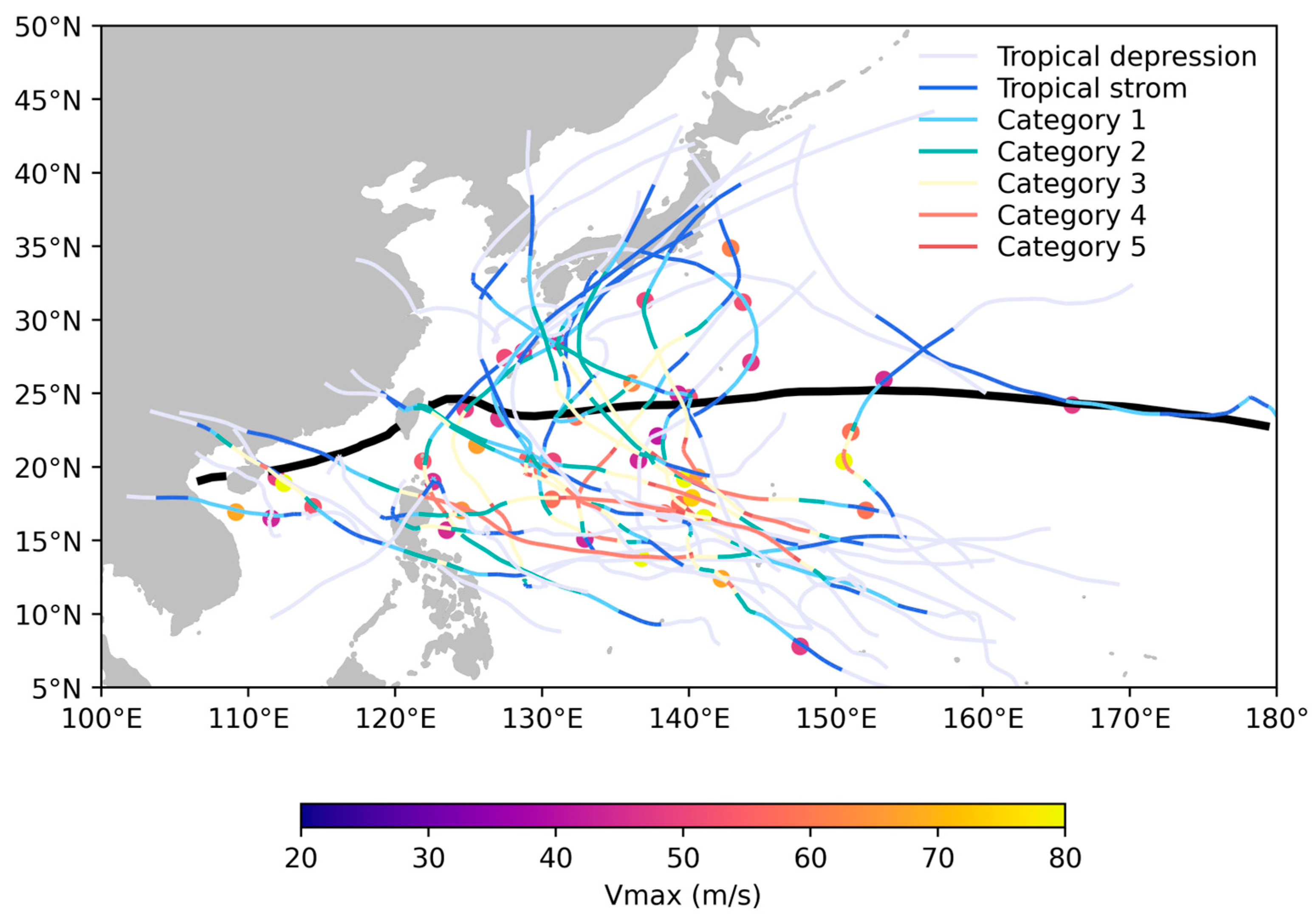
2.1.1. Synthetic Aperture Radar (SAR)
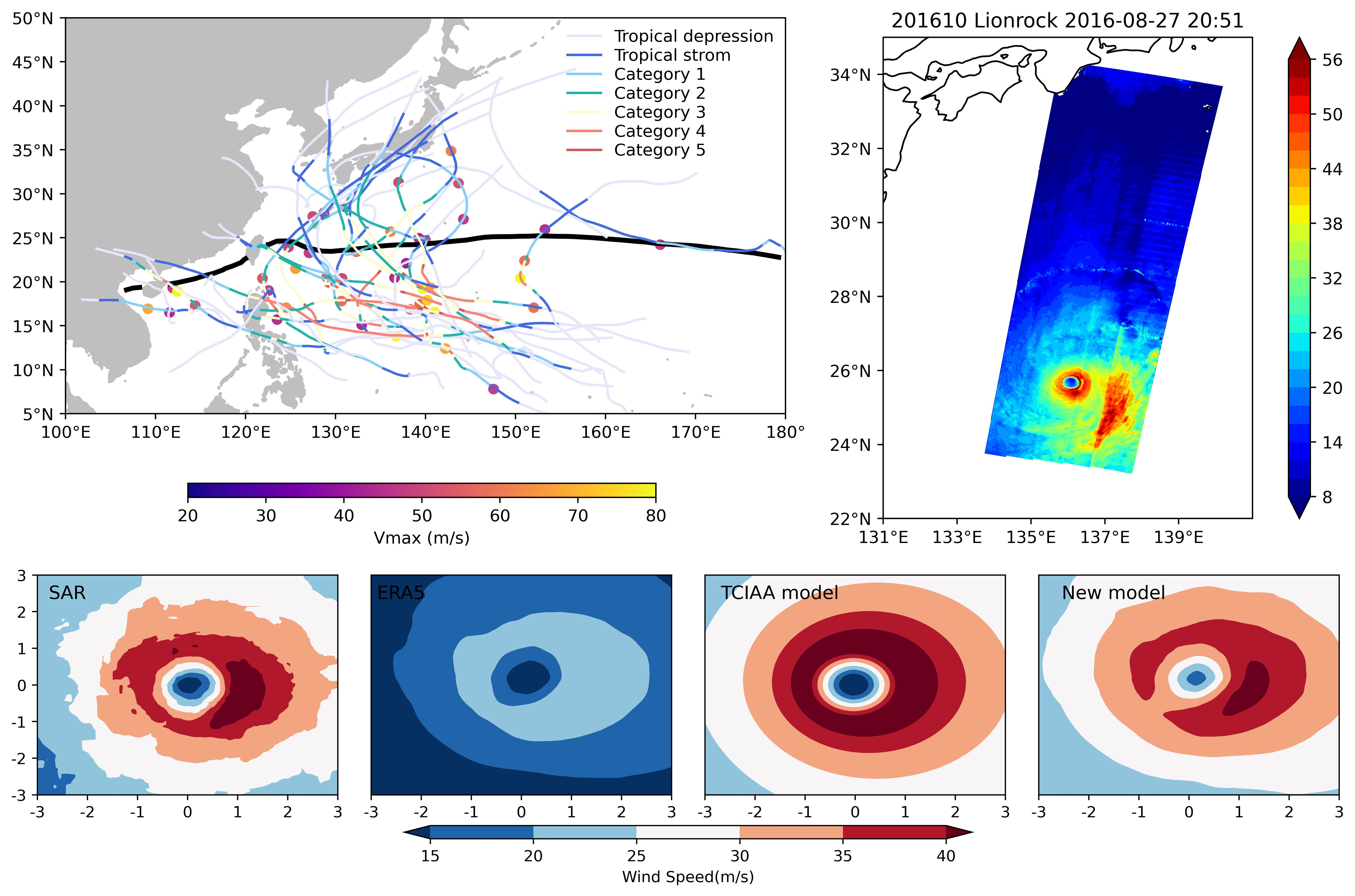
2.1.2. International Best Track Archive for Climate Stewardship (IBTrACS)
2.1.3. GPM_3IMERGHH
2.1.4. ERA5 Reanalysis Data
2.1.5. COBE Sea Surface Temperature
2.2. Methods
2.2.1. Data Analysis and Statistical Methods
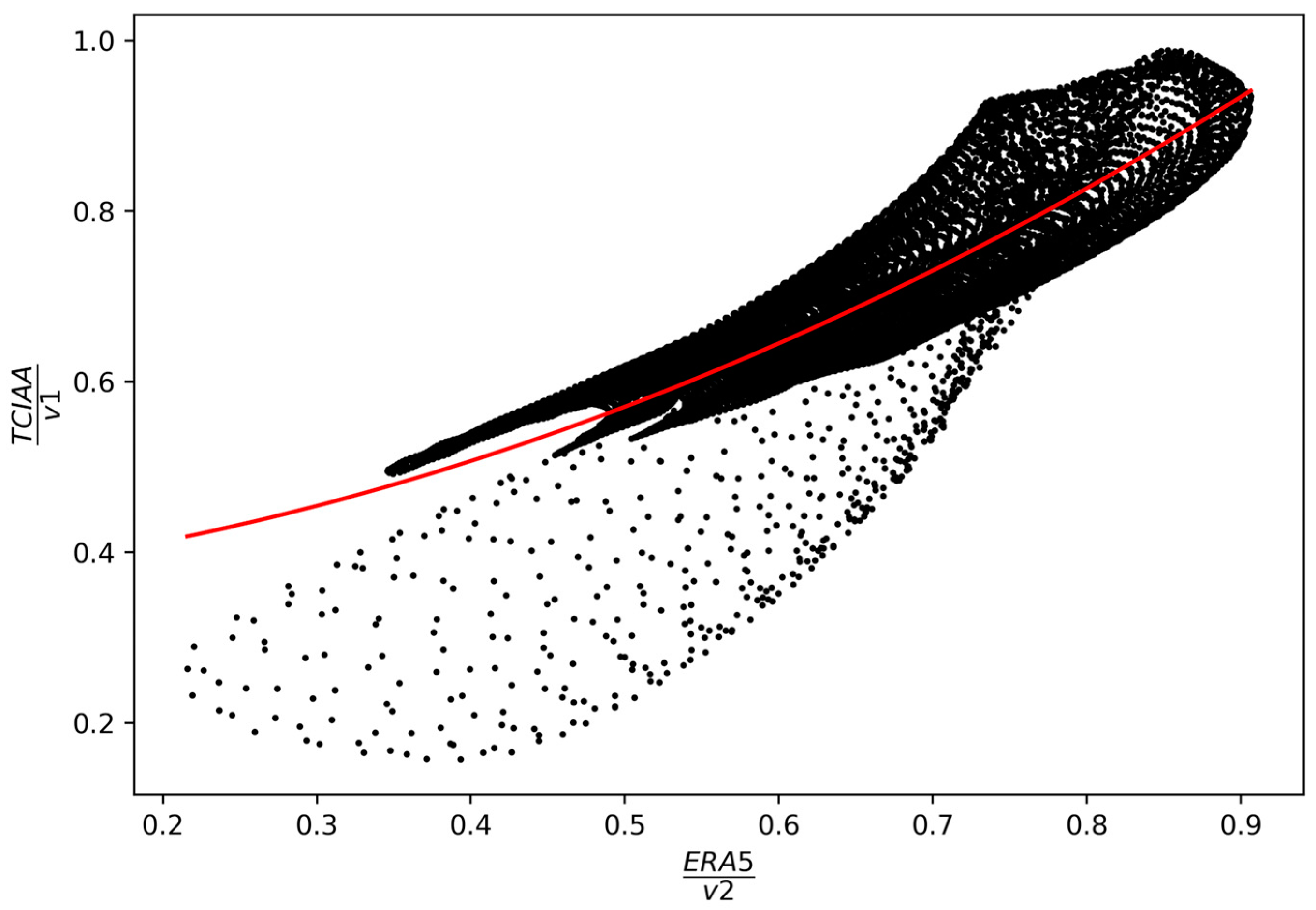
2.2.2. TCIAA Model
3. Results
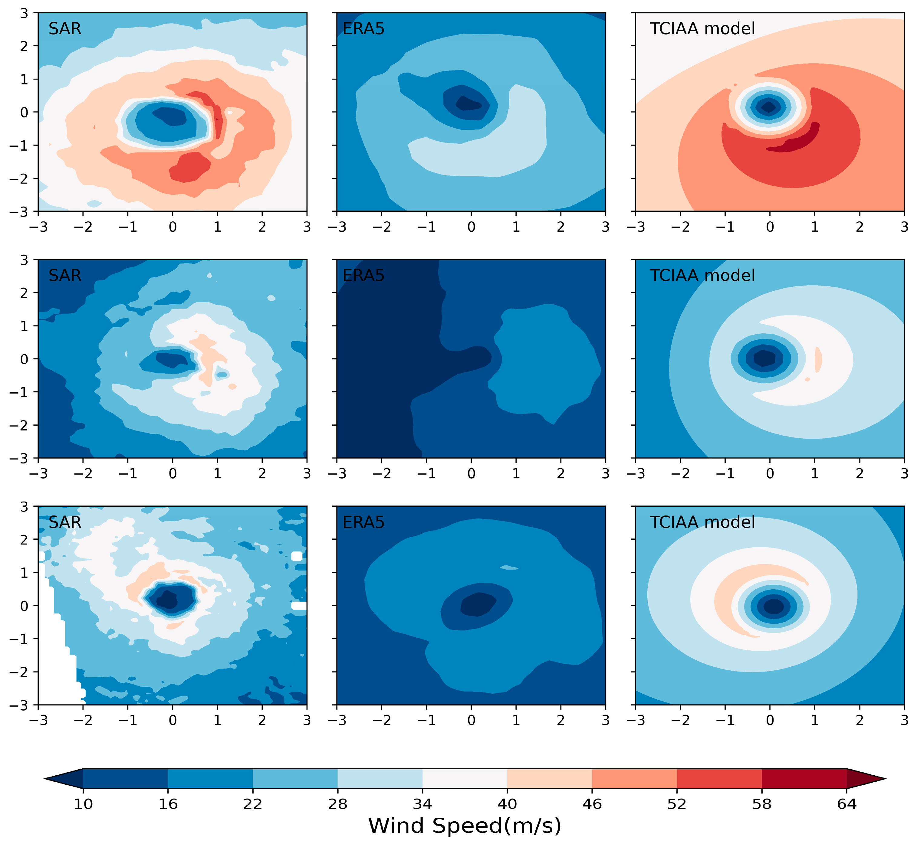
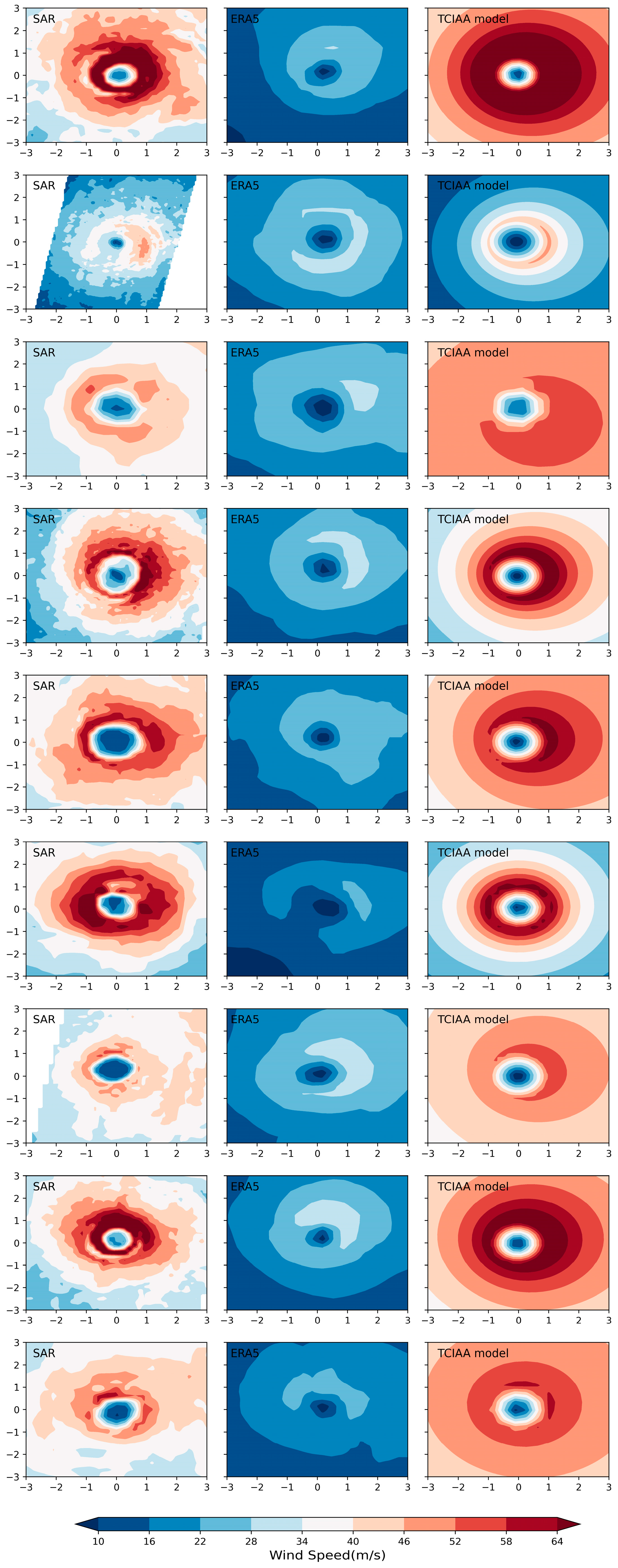
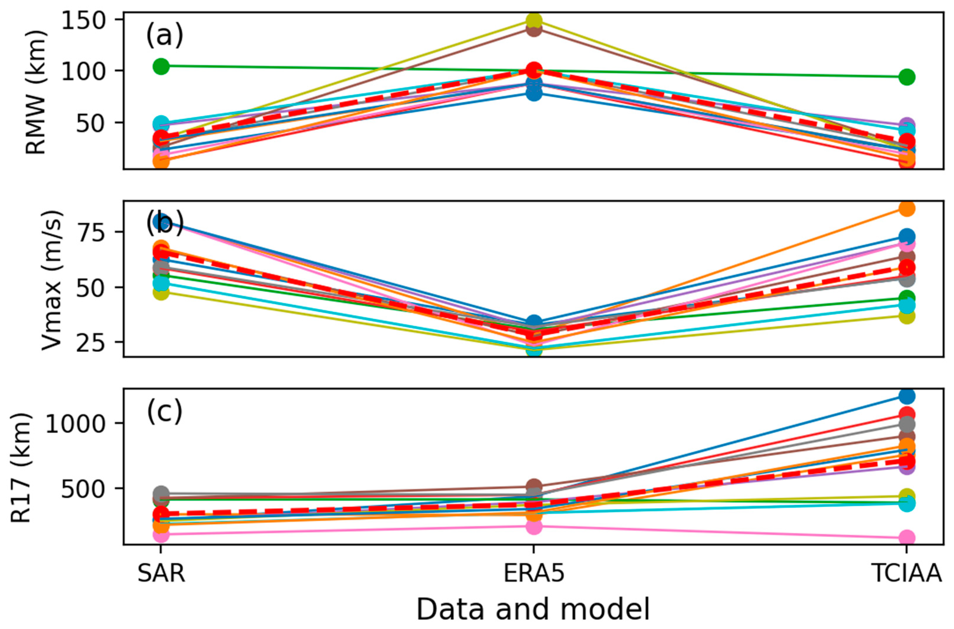
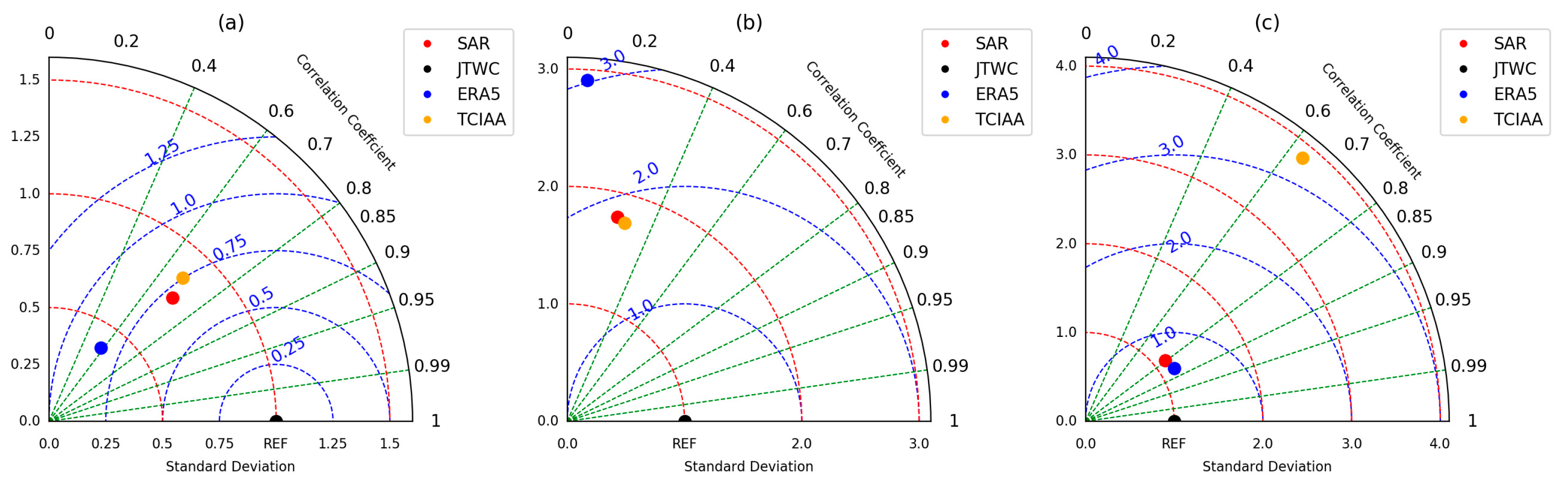
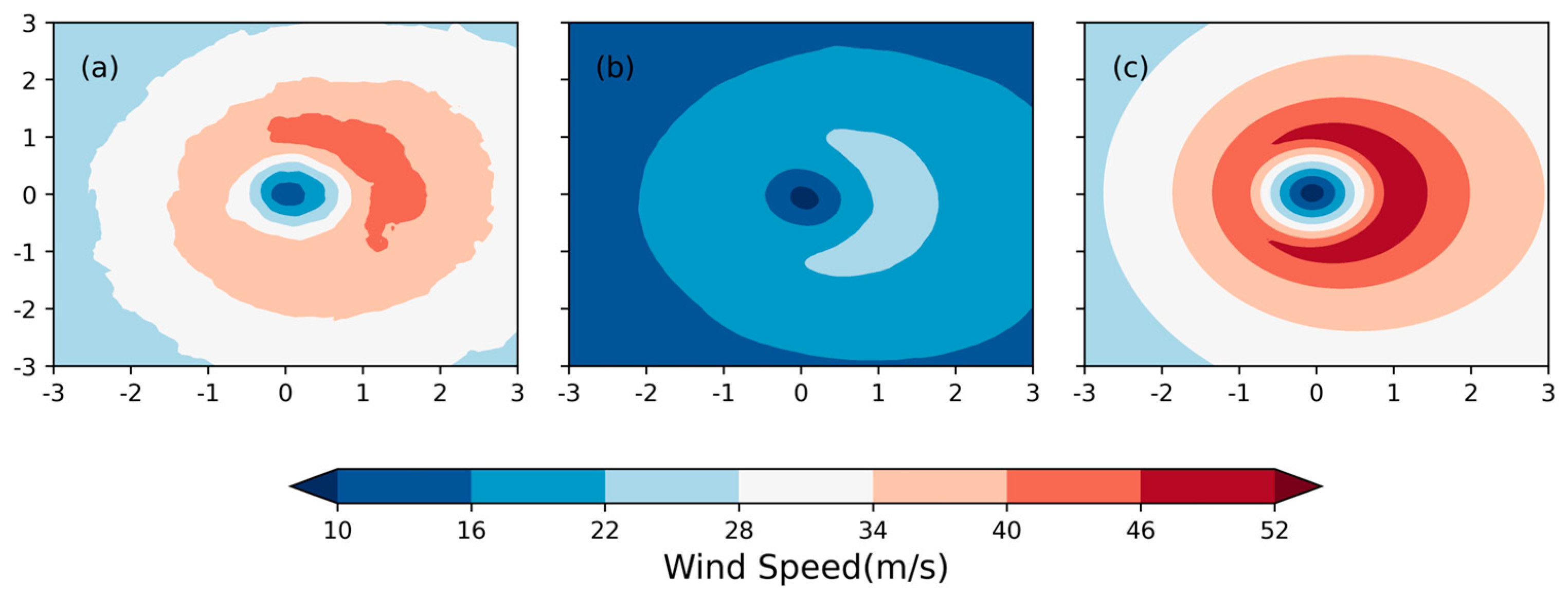
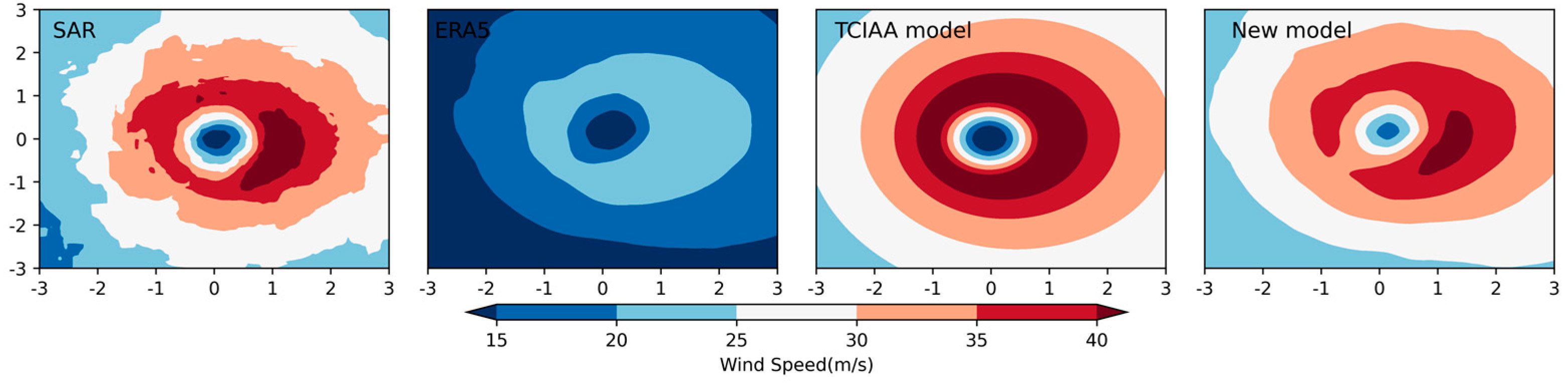
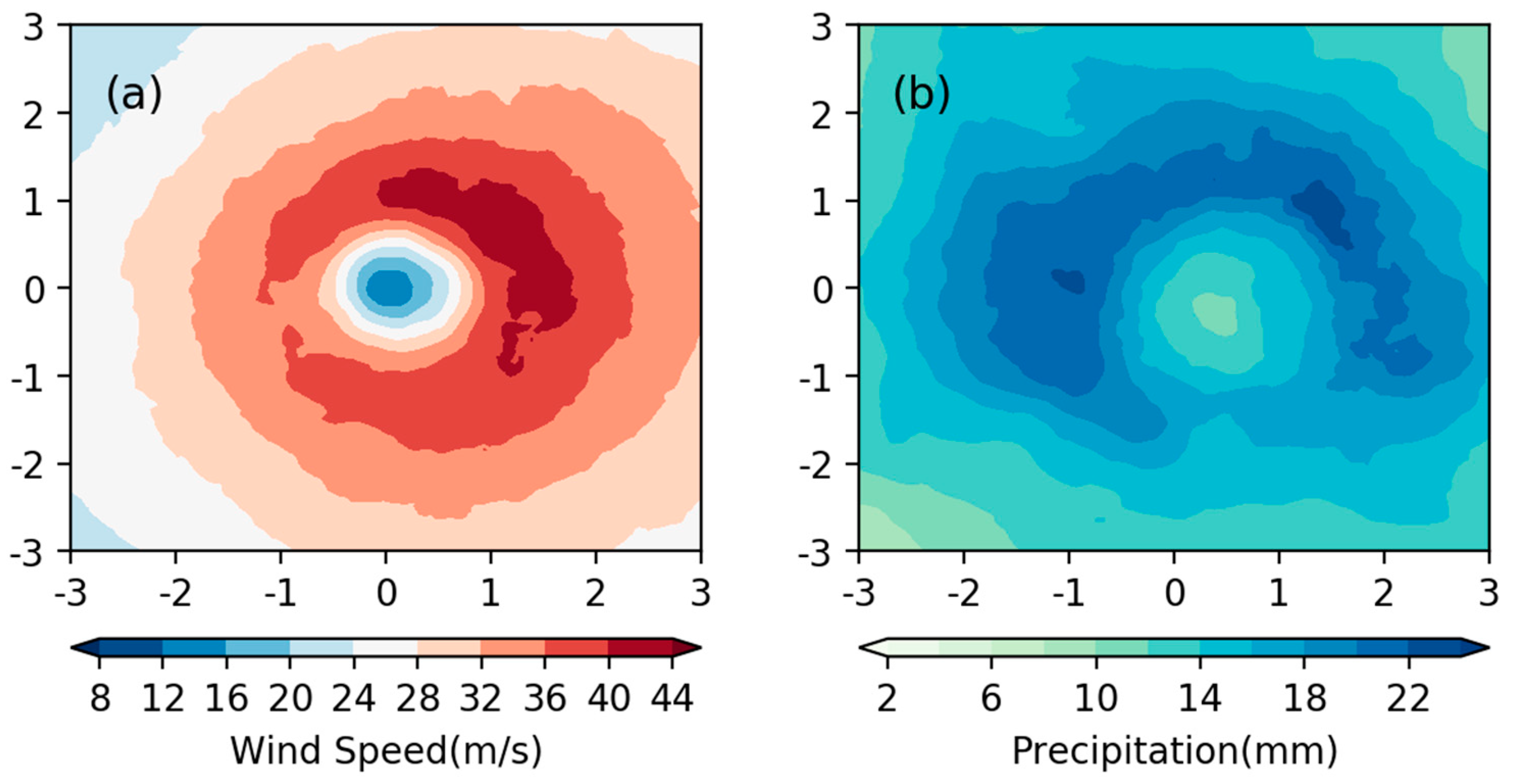
3.1. Wind Field Comparison
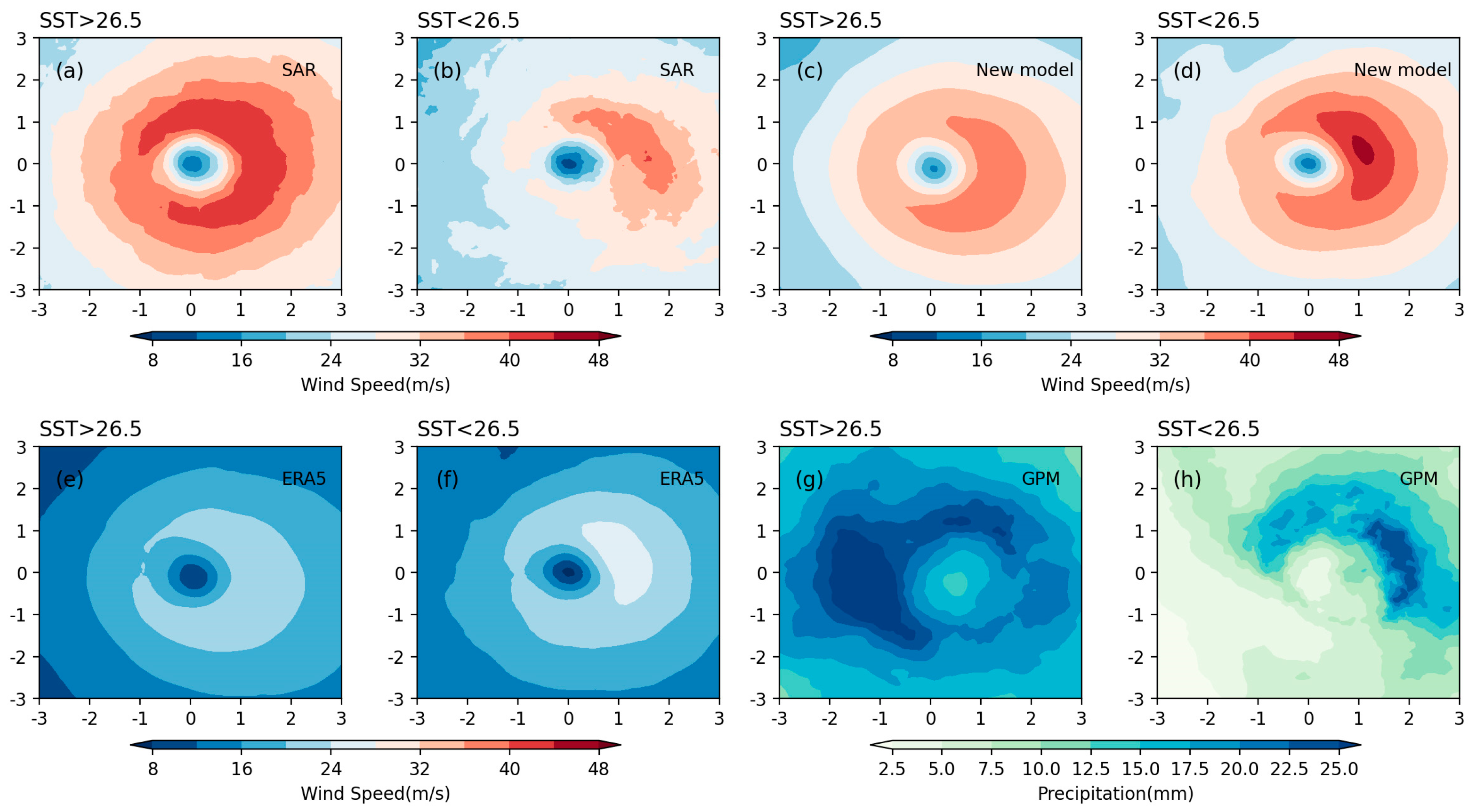
3.2. The Influence of SST on TC Wind Field and Precipitation
4. Conclusions
Author Contributions
Funding
Data Availability Statement
Acknowledgments
Conflicts of Interest
References
- Chen, L.; Xu, Y. Review of Typhoon Very Heavy Rainfall in China. Meteorol. Environ. Sci. 2017, 40, 3–10. [Google Scholar]
- Done, J.; Ge, M.; Holland, G.; Dima, I.; Phibbs, S.; Saville, G.; Wang, Y. Modelling global tropical cyclone wind footprints. Nat. Hazards Earth Syst. Sci. 2020, 20, 567–580. [Google Scholar] [CrossRef]
- Lu, Y.; Zhao, H.; Zhao, D.; Qingqing, L. Spatial-temporal characteristic of tropical cyclone disasters in China during 1984–2017. Haiyang Xuebao 2021, 43, 45–61. [Google Scholar]
- Emanuel, K.A. The dependence of hurricane intensity on climate. Nature 1987, 326, 483–485. [Google Scholar] [CrossRef]
- Knutson, T.R.; Tuleya, R.E. Impact of CO2-Induced Warming on Simulated Hurricane Intensity and Precipitation: Sensitivity to the Choice of Climate Model and Convective Parameterization. J. Clim. 2004, 17, 3477–3495. [Google Scholar] [CrossRef]
- Knutson, T.R.; McBride, J.L.; Chan, J.; Emanuel, K.; Holland, G.; Landsea, C.; Held, I.; Kossin, J.P.; Srivastava, A.K.; Sugi, M. Tropical cyclones and climate change. Nat. Geosci. 2010, 3, 157–163. [Google Scholar] [CrossRef]
- Webster, P.J.; Holland, G.J.; Curry, J.A.; Chang, H.-R. Changes in Tropical Cyclone Number, Duration, and Intensity in a Warming Environment. Science 2005, 309, 1844–1846. [Google Scholar] [CrossRef]
- Guishan, Y. Historical change and future trends of storm surge disaster in China’s coastal area. J. Nat. Disasters 2000, 9, 23–30. [Google Scholar]
- Emanuel, K.A. Increasing destructiveness of tropical cyclones over the past 30 years. Nature 2005, 436, 686–688. [Google Scholar] [CrossRef]
- Ge, Y.; Zhao, L.; Xiang, H. Review for numerical typhoon models based on extreme wind velocity prediction. J. Nat. Disasters 2003, 12, 31–40. [Google Scholar]
- Zhou, L.; Chen, D.; Lei, X.; Wang, W.; Wang, G.; Han, G. Progress and perspective on interactions between ocean and typhoon. Chin. Sci. Bull. 2019, 64, 60. [Google Scholar] [CrossRef]
- Ma, Y.; Zhang, Q. Approaches to Several Problems about Progress in the Study of Typhoon. J. Oceanogr. Huanghai Bohai Seas 1999, 17, 62–65. [Google Scholar]
- Russell, L.R. Probability Distributions for Hurricane Effects. J. Waterw. Harb. Coast. Eng. Div. 1971, 97, 139–154. [Google Scholar] [CrossRef]
- Batts, M.E.; Simiu, E.; Russell, L.R. Hurricane Wind Speeds in the United States. J. Struct. Div. 1980, 106, 2001–2016. [Google Scholar] [CrossRef]
- Holland, G.J. An Analytic Model of the Wind and Pressure Profiles in Hurricanes. Mon. Weather Rev. 1980, 108, 1212–1218. [Google Scholar] [CrossRef]
- Shapiro, L.J. The Asymmetric Boundary layer Flow Under a Translating Hurricane. J. Atmos. Sci. 1983, 40, 1984–1998. [Google Scholar] [CrossRef]
- Meng, Y.; Matsui, M.; Hibi, K. An analytical model for simulation of the wind field in a typhoon boundary layer. J. Wind Eng. Ind. Aerodyn. 1995, 56, 291–310. [Google Scholar] [CrossRef]
- Gao, Y.; Zhang, J.; Sun, J.; Guan, C. Application of SAR Data for Tropical Cyclone Intensity Parameters Retrieval and Symmetric Wind Field Model Development. Remote Sens. 2021, 13, 2902. [Google Scholar] [CrossRef]
- Zhang, G.; Li, X.; Perrie, W.; Zhang, J.A. Tropical Cyclone Winds and Inflow Angle Asymmetry From SAR Imagery. Geophys. Res. Lett. 2021, 48, e2021GL095699. [Google Scholar] [CrossRef]
- Fang, G.; Zhao, L.; Cao, S.; Ge, Y.; Pang, W. A novel analytical model for wind field simulation under typhoon boundary layer considering multi-field correlation and height-dependency. J. Wind Eng. Ind. Aerodyn. 2018, 175, 77–89. [Google Scholar] [CrossRef]
- Fang, G.; Zhao, L.; Cao, S.; Zhu, L.; Ge, Y. Estimation of tropical cyclone wind hazards in coastal regions of China. Nat. Hazards Earth Syst. Sci. 2020, 20, 1617–1637. [Google Scholar] [CrossRef]
- Snaiki, R.; Wu, T. A linear height-resolving wind field model for tropical cyclone boundary layer. J. Wind Eng. Ind. Aerodyn. 2017, 171, 248–260. [Google Scholar] [CrossRef]
- Jacob, S.D.; Koblinsky, C.J. Effects of Precipitation on the Upper-Ocean Response to a Hurricane. Mon. Weather Rev. 2007, 135, 2207–2225. [Google Scholar] [CrossRef]
- Jourdain, N.C.; Lengaigne, M.; Vialard, J.; Madec, G.; Menkes, C.E.; Vincent, E.M.; Jullien, S.; Barnier, B. Observation-Based Estimates of Surface Cooling Inhibition by Heavy Rainfall under Tropical Cyclones. J. Phys. Oceanogr. 2013, 43, 205–221. [Google Scholar] [CrossRef]
- Lin, Y.; Zhao, M.; Zhang, M. Tropical cyclone rainfall area controlled by relative sea surface temperature. Nat. Commun. 2015, 6, 6591. [Google Scholar] [CrossRef]
- Zhang, B.; Perrie, W. Cross-Polarized Synthetic Aperture Radar: A New Potential Measurement Technique for Hurricanes. Bull. Am. Meteorol. Soc. 2012, 93, 531–541. [Google Scholar] [CrossRef]
- Mouche, A.A.; Chapron, B.; Zhang, B.; Husson, R. Combined Co- and Cross-Polarized SAR Measurements Under Extreme Wind Conditions. IEEE Trans. Geosci. Remote Sens. 2017, 55, 6746–6755. [Google Scholar] [CrossRef]
- Sapp, J.W.; Alsweiss, S.O.; Jelenak, Z.; Chang, P.S.; Frasier, S.J.; Carswell, J.R. Airborne Co-polarization and Cross-Polarization Observations of the Ocean-Surface NRCS at C-Band. IEEE Trans. Geosci. Remote Sens. 2016, 54, 5975–5992. [Google Scholar] [CrossRef]
- Fernandez, D.E.; Carswell, J.R.; Frasier, S.; Chang, P.S.; Black, P.G.; Marks, F.D. Dual-polarized C- and Ku-band ocean backscatter response to hurricane-force winds. J. Geophys. Res. Ocean. 2006, 111, C08013. [Google Scholar] [CrossRef]
- Knapp, K.R.; Kruk, M.C.; Levinson, D.H.; Diamond, H.J.; Neumann, C.J. The International Best Track Archive for Climate Stewardship (IBTrACS): Unifying Tropical Cyclone Data. Bull. Am. Meteorol. Soc. 2010, 91, 363–376. [Google Scholar] [CrossRef]
- Kruk, M.C.; Knapp, K.R.; Levinson, D.H. A Technique for Combining Global Tropical Cyclone Best Track Data. J. Atmos. Ocean. Technol. 2010, 27, 680–692. [Google Scholar] [CrossRef]
- Levinson, D.; Diamond, H.; Knapp, K.; Kruk, M.; Gibney, E. Toward a Homogenous Global Tropical Cyclone Best-Track Dataset. Bull. Am. Meteorol. Soc. 2010, 91, 377–380. [Google Scholar]
- Jin, D.; Oreopoulos, L.; Lee, D.; Tan, J.; Cho, N. Cloud–Precipitation Hybrid Regimes and Their Projection onto IMERG Precipitation Data. J. Appl. Meteorol. Climatol. 2021, 60, 733–748. [Google Scholar] [CrossRef]
- Hersbach, H.; Bell, B.; Berrisford, P.; Hirahara, S.; Horányi, A.; Muñoz-Sabater, J.; Nicolas, J.; Peubey, C.; Radu, R.; Schepers, D.; et al. The ERA5 global reanalysis. Q. J. R. Meteorol. Soc. 2020, 146, 1999–2049. [Google Scholar] [CrossRef]
- Ishii, M.; Shouji, A.; Sugimoto, S.; Matsumoto, T. Objective analyses of sea-surface temperature and marine meteorological variables for the 20th century using ICOADS and the Kobe Collection. Int. J. Climatol. 2005, 25, 865–879. [Google Scholar] [CrossRef]
- Wu, L.; Tian, W.; Liu, Q.; Cao, J.; Knaff, J.A. Implications of the Observed Relationship between Tropical Cyclone Size and Intensity over the Western North Pacific. J. Clim. 2015, 28, 9501–9506. [Google Scholar] [CrossRef]
- Knaff, J.A.; Longmore, S.P.; DeMaria, R.T.; Molenar, D.A. Improved Tropical-Cyclone Flight-Level Wind Estimates Using Routine Infrared Satellite Reconnaissance. J. Appl. Meteorol. Climatol. 2015, 54, 463–478. [Google Scholar] [CrossRef]
- Hodges, K.; Cobb, A.; Vidale, P.L. How Well Are Tropical Cyclones Represented in Reanalysis Datasets? J. Clim. 2017, 30, 5243–5264. [Google Scholar] [CrossRef]
- Mechem, D.B.; Chen, S.S.; Houze, R.A., Jr. Momentum transport processes in the stratiform regions of mesoscale convective systems over the western Pacific warm pool. Q. J. R. Meteorol. Soc. 2006, 132, 709–736. [Google Scholar] [CrossRef]
- Rogers, R.; Chen, S.; Tenerelli, J.; Willoughby, H. A Numerical Study of the Impact of Vertical Shear on the Distribution of Rainfall in Hurricane Bonnie (1998). Mon. Weather Rev. 2003, 131, 1577–1599. [Google Scholar] [CrossRef]
- Chen, S.S.; Knaff, J.A.; Marks, F.D. Effects of Vertical Wind Shear and Storm Motion on Tropical Cyclone Rainfall Asymmetries Deduced from TRMM. Mon. Weather Rev. 2006, 134, 3190–3208. [Google Scholar] [CrossRef]
- Tournadre, J.; Quilfen, Y. Impact of rain cell on scatterometer data: 1. Theory and modeling. J. Geophys. Res. Ocean. 2003, 108, 3225. [Google Scholar] [CrossRef]


| RMW | Vmax | R17 | |
|---|---|---|---|
| Mean | 47.37/116.1/44.64 | 56.71/26.26/50.11 | 273.96/357.77/557.46 |
| Standard deviation | 36.62/59.43/35.72 | 11.32/5.8/12.69 | 101.29/104.41/344.85 |
| Correlation with JTWC | 0.24/0.06/0.28 | 0.71/0.58/0.68 | 0.8/0.86/0.64 |
Disclaimer/Publisher’s Note: The statements, opinions and data contained in all publications are solely those of the individual author(s) and contributor(s) and not of MDPI and/or the editor(s). MDPI and/or the editor(s) disclaim responsibility for any injury to people or property resulting from any ideas, methods, instructions or products referred to in the content. |
© 2023 by the authors. Licensee MDPI, Basel, Switzerland. This article is an open access article distributed under the terms and conditions of the Creative Commons Attribution (CC BY) license (https://creativecommons.org/licenses/by/4.0/).
Share and Cite
Du, R.; Zhang, G.; Huang, B. Observed Surface Wind Field Structure of Severe Tropical Cyclones and Associated Precipitation. Remote Sens. 2023, 15, 2808. https://doi.org/10.3390/rs15112808
Du R, Zhang G, Huang B. Observed Surface Wind Field Structure of Severe Tropical Cyclones and Associated Precipitation. Remote Sensing. 2023; 15(11):2808. https://doi.org/10.3390/rs15112808
Chicago/Turabian StyleDu, Rong, Guosheng Zhang, and Bin Huang. 2023. "Observed Surface Wind Field Structure of Severe Tropical Cyclones and Associated Precipitation" Remote Sensing 15, no. 11: 2808. https://doi.org/10.3390/rs15112808
APA StyleDu, R., Zhang, G., & Huang, B. (2023). Observed Surface Wind Field Structure of Severe Tropical Cyclones and Associated Precipitation. Remote Sensing, 15(11), 2808. https://doi.org/10.3390/rs15112808