Reconstruction of a Monthly 1 km NDVI Time Series Product in China Using Random Forest Methodology
Abstract
1. Introduction
2. Study Area and Datasets
2.1. Study Area
2.2. Datasets
3. Methodology
3.1. Data Preprocessing
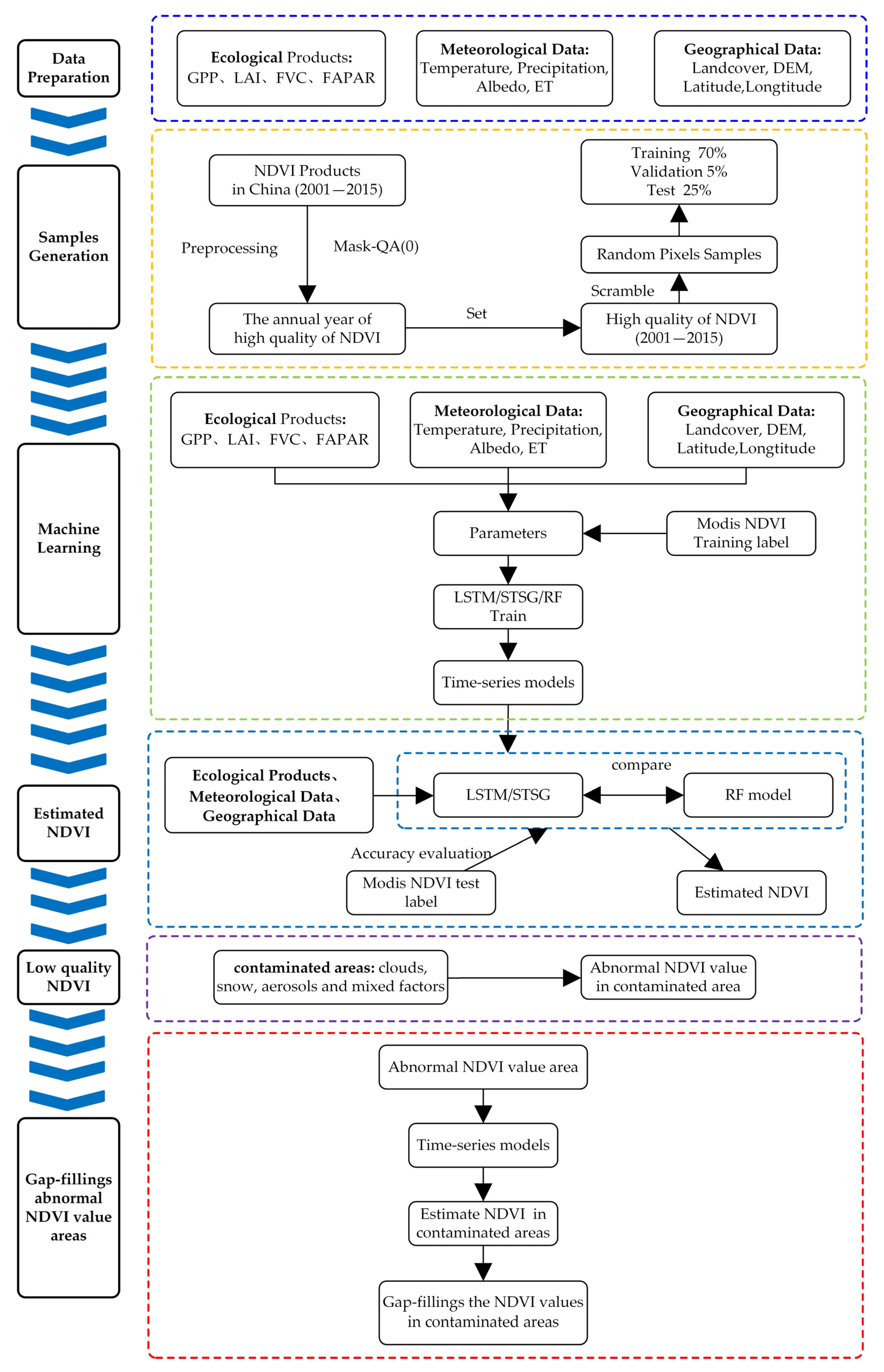
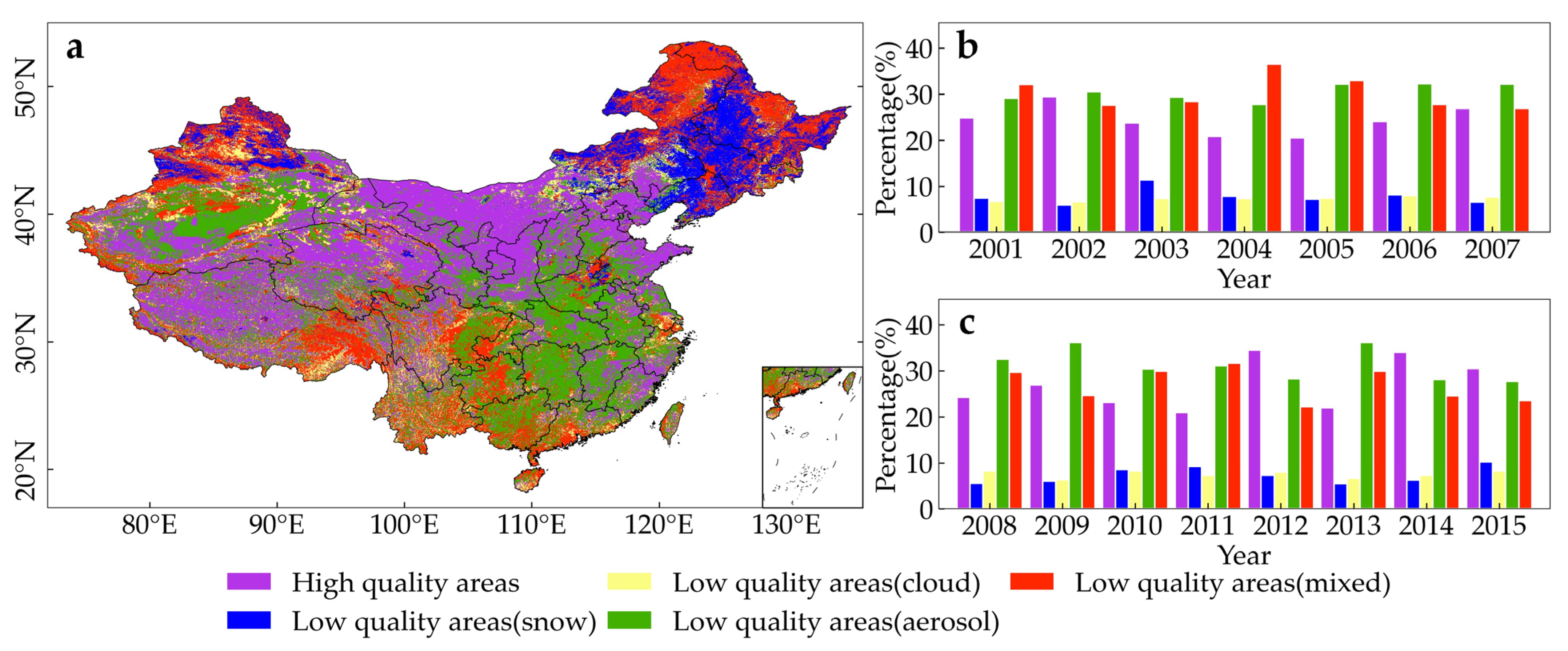
3.2. Training Samples from High-Quality Areas of MODIS NDVI in China
3.3. Reconstruction Models
3.3.1. RF Model and Optional Parameters
3.3.2. LSTM Model and Optional Parameters
3.3.3. STSG Model and Optional Parameters
4. Results
4.1. Product Intercomparison
4.2. The Comparison of Biome Categories
4.3. Model Validation
5. Discussion
5.1. Differences between the RF Method and Previous Methods
5.2. The Limitation of the RF Method
6. Conclusions
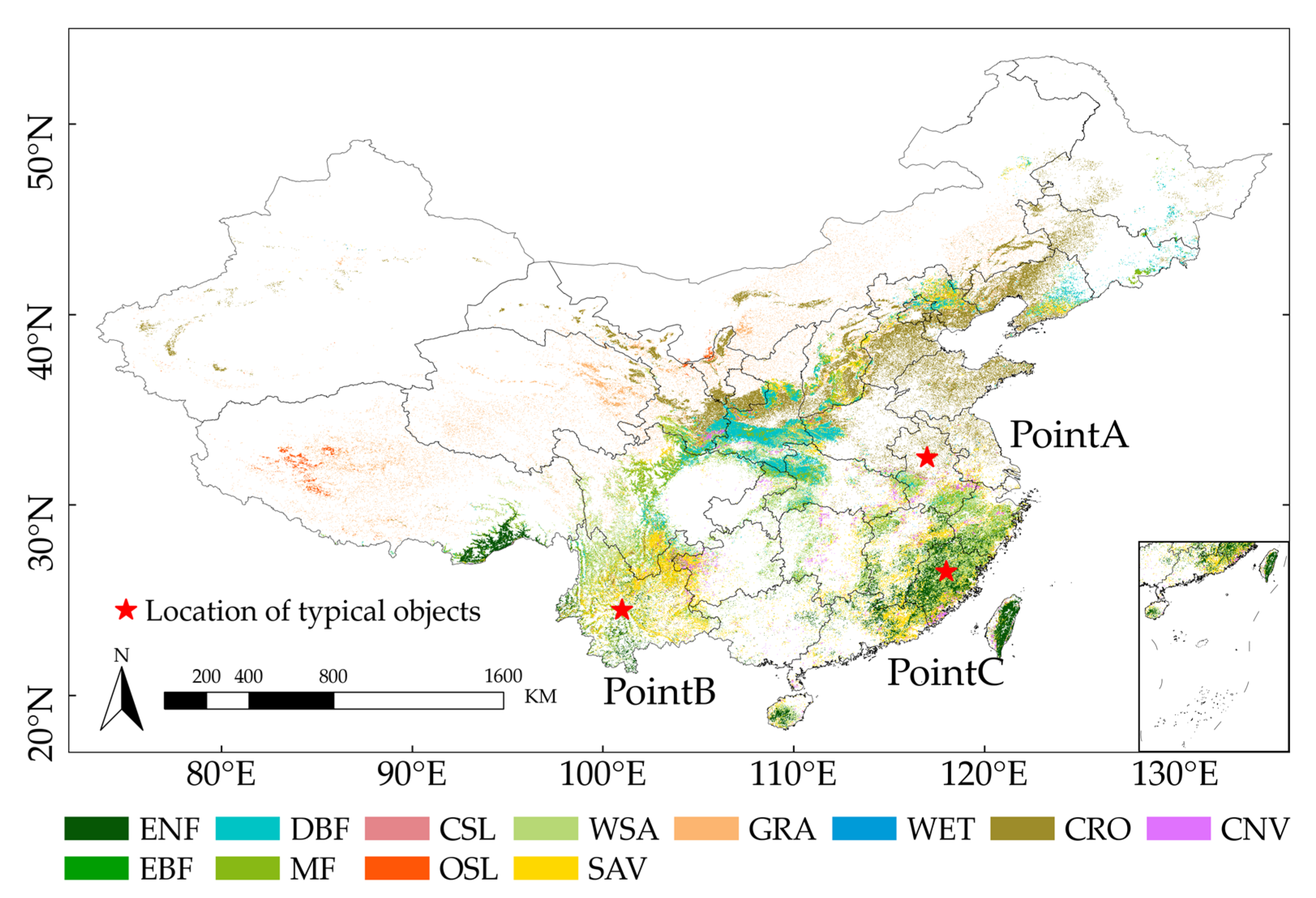
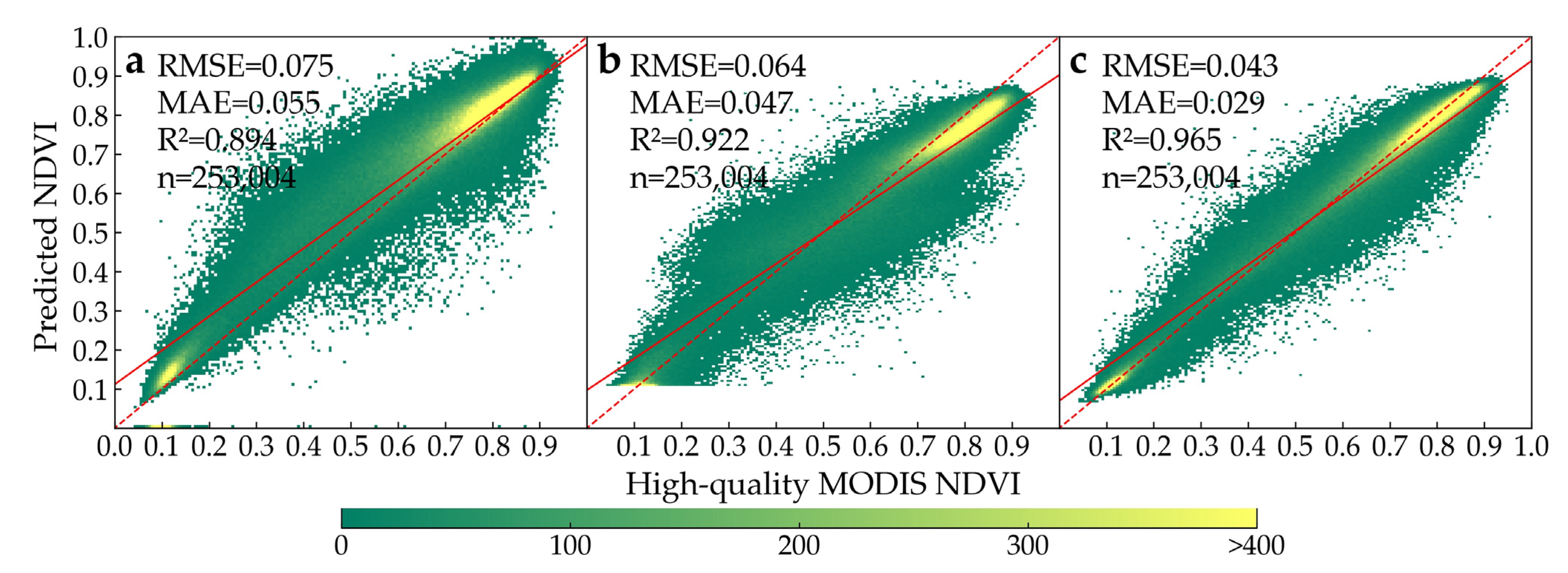
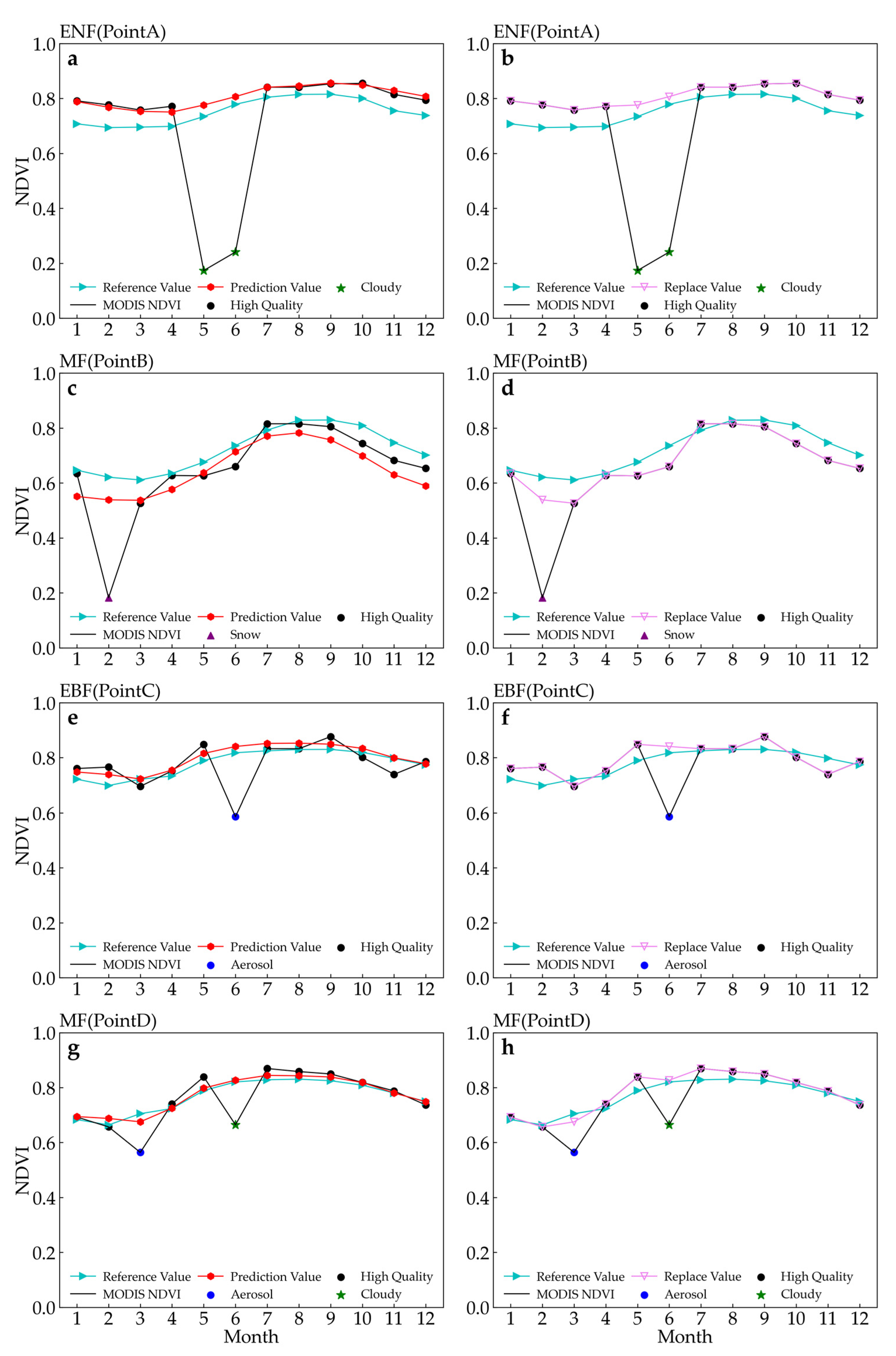
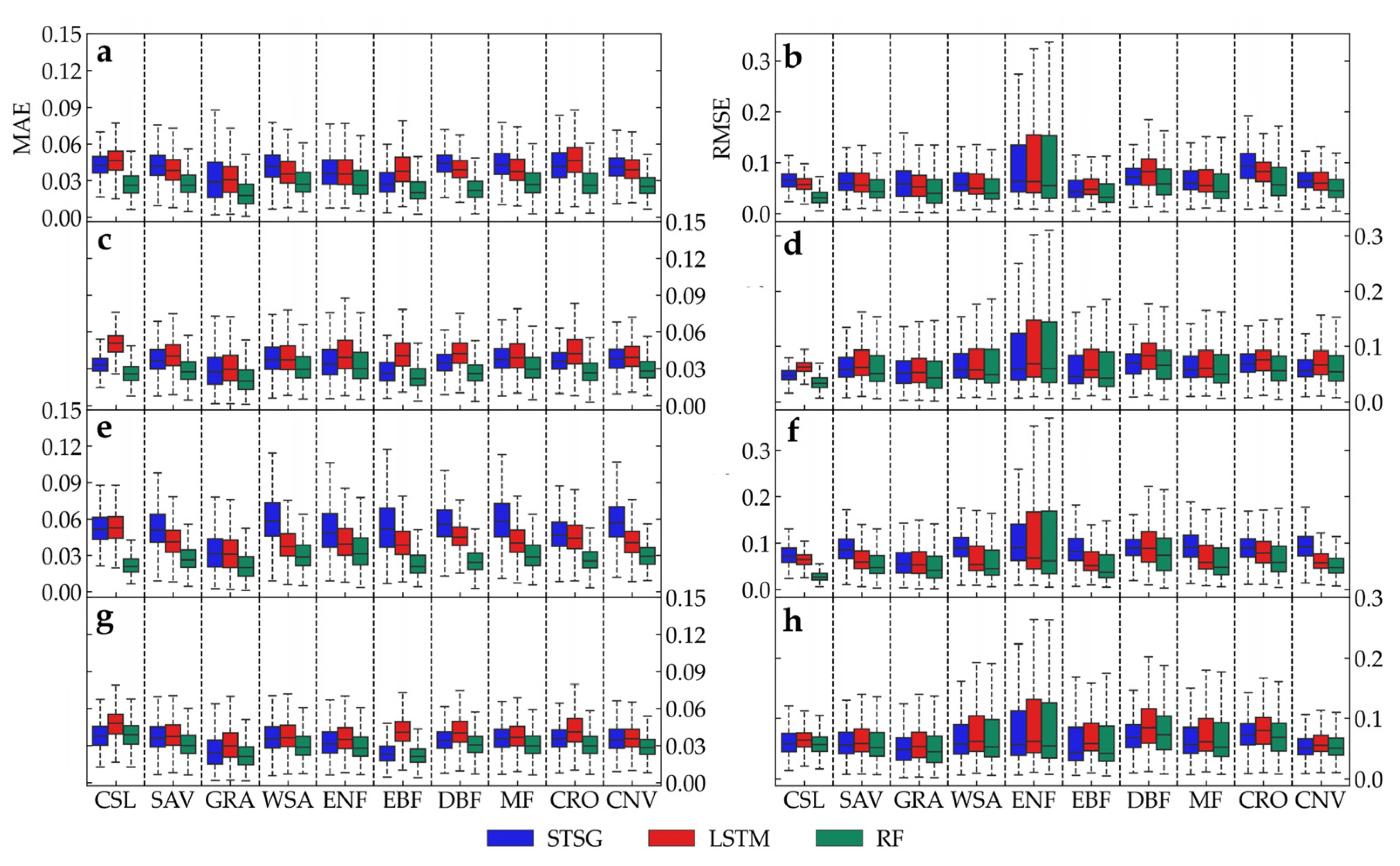
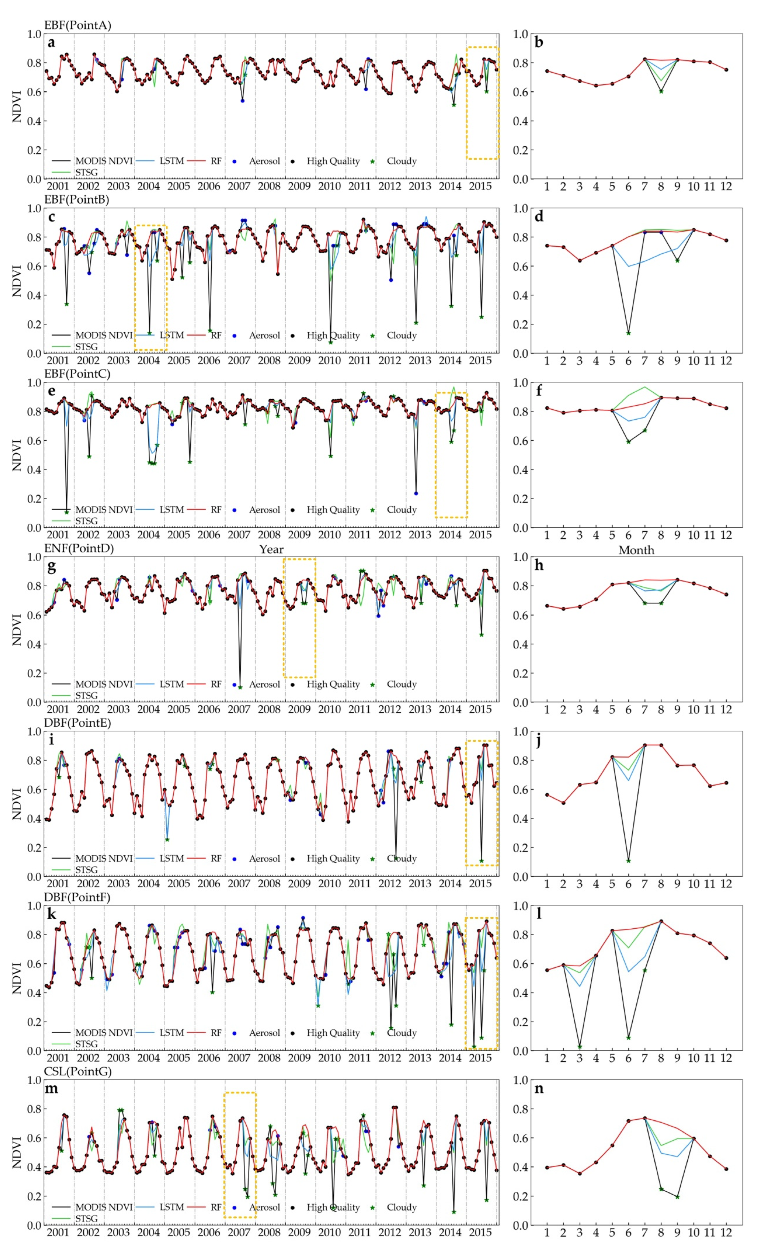
- The performance of the models correcting the contaminated pixels was tested using the site-based method, which included the NDVI simulation in TCA and the actual ground observations (points A, B, and C). The results showed that the RF model had a lower MAE and RMSE than LSTM and STSG, and the correction was very close to the high-quality areas regardless of the biome type.
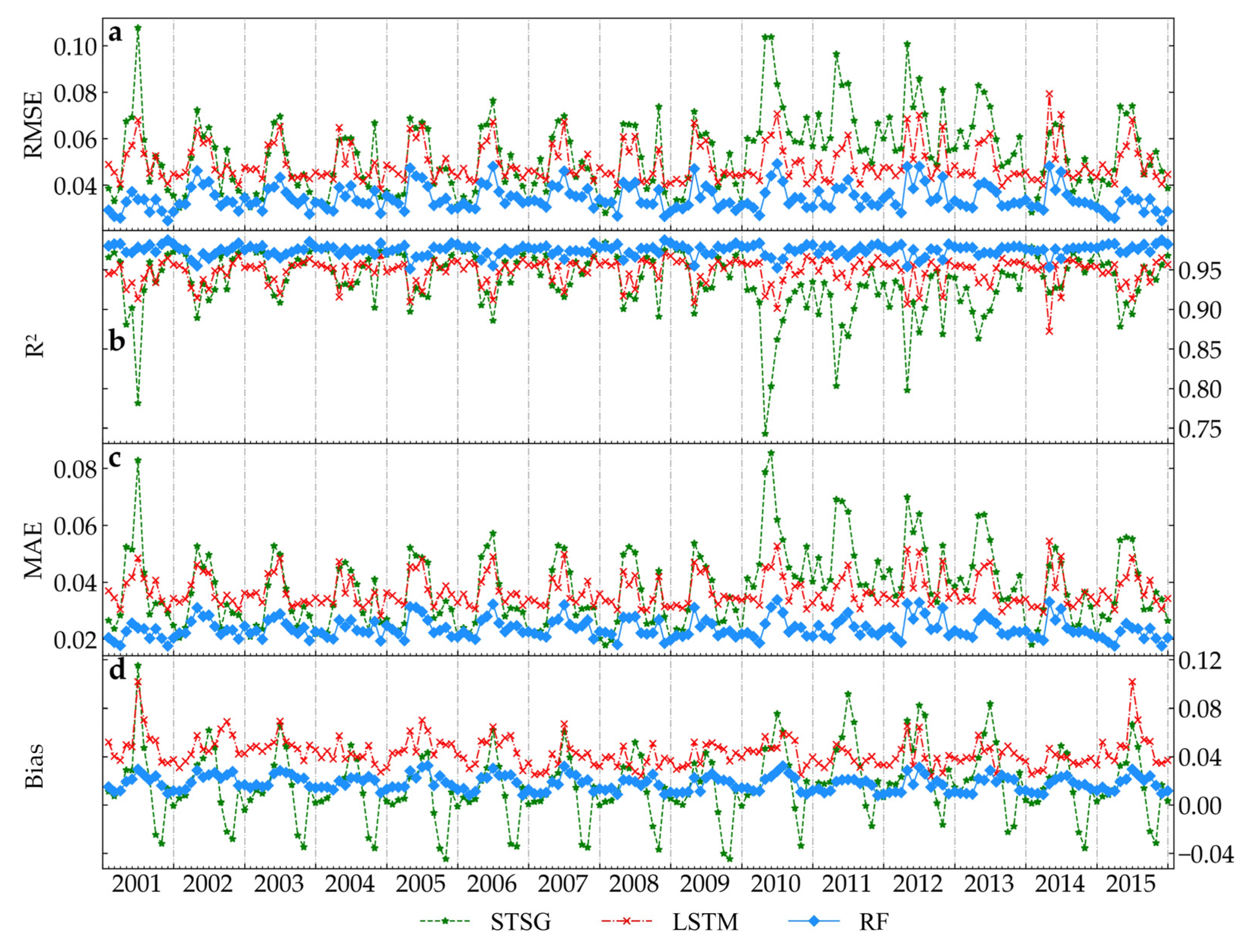
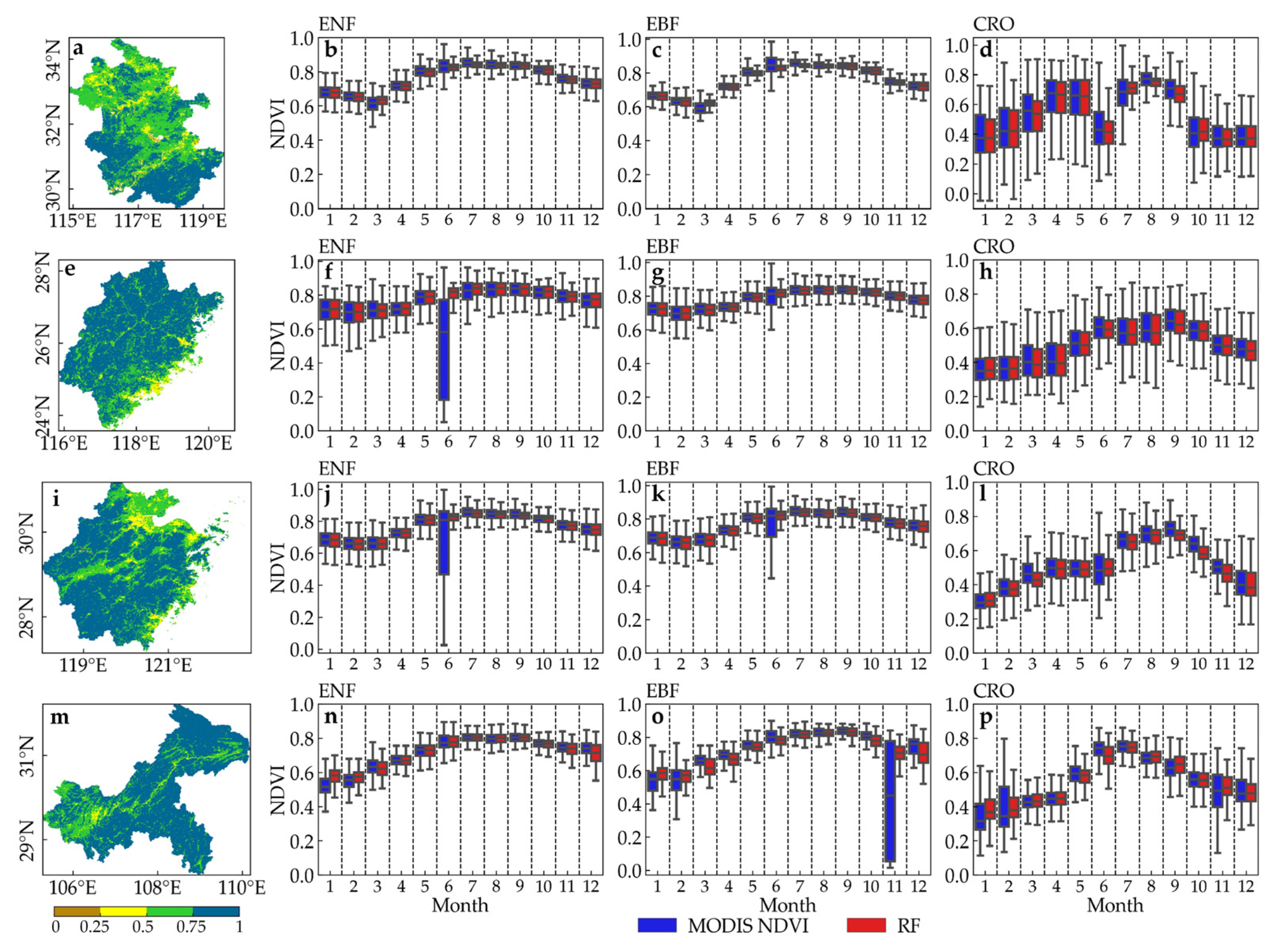
- The performance of the models was tested using the time sequence test, and we found that the reconstructed NDVI had the lowest MAE and RMSE in the time series from 2001 to 2015.
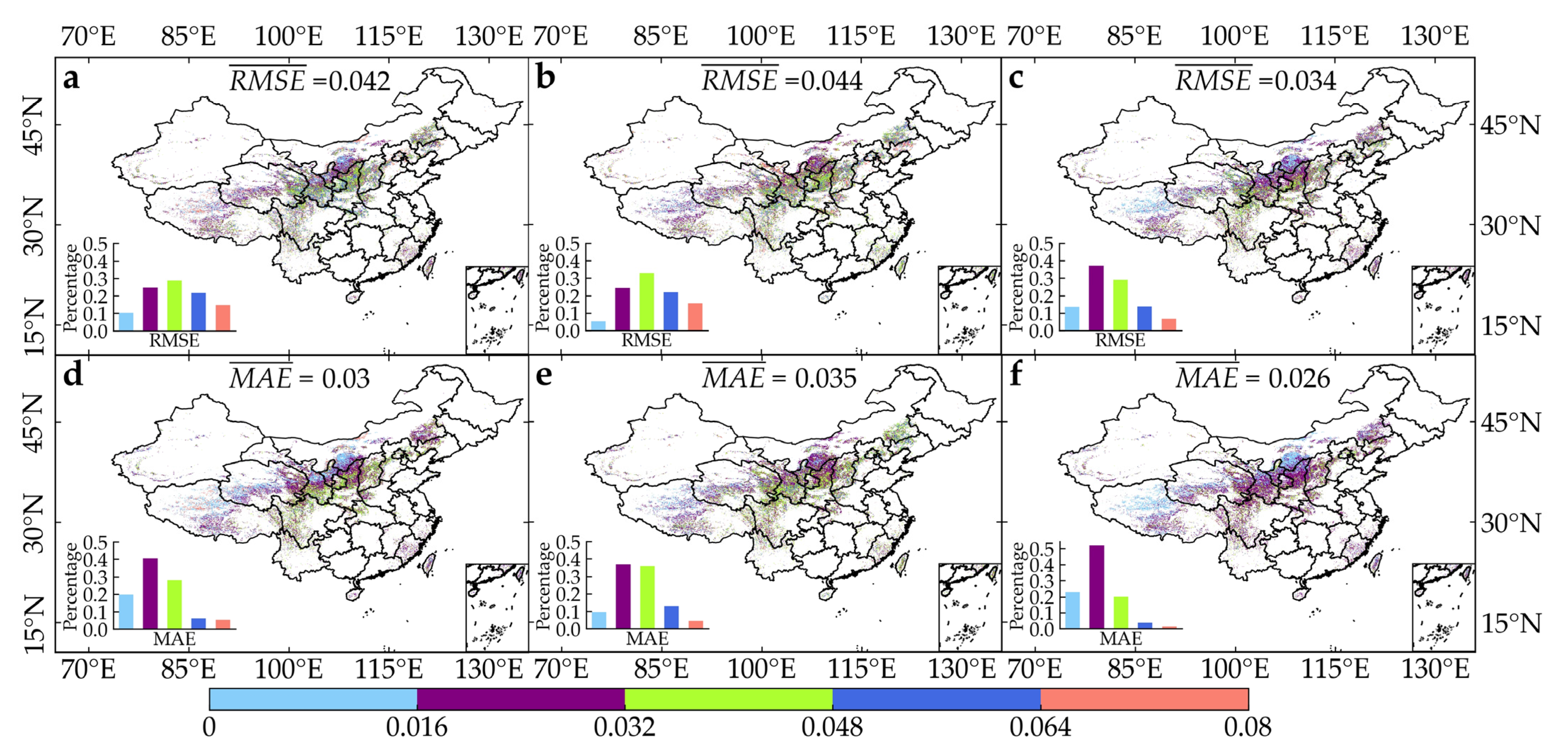
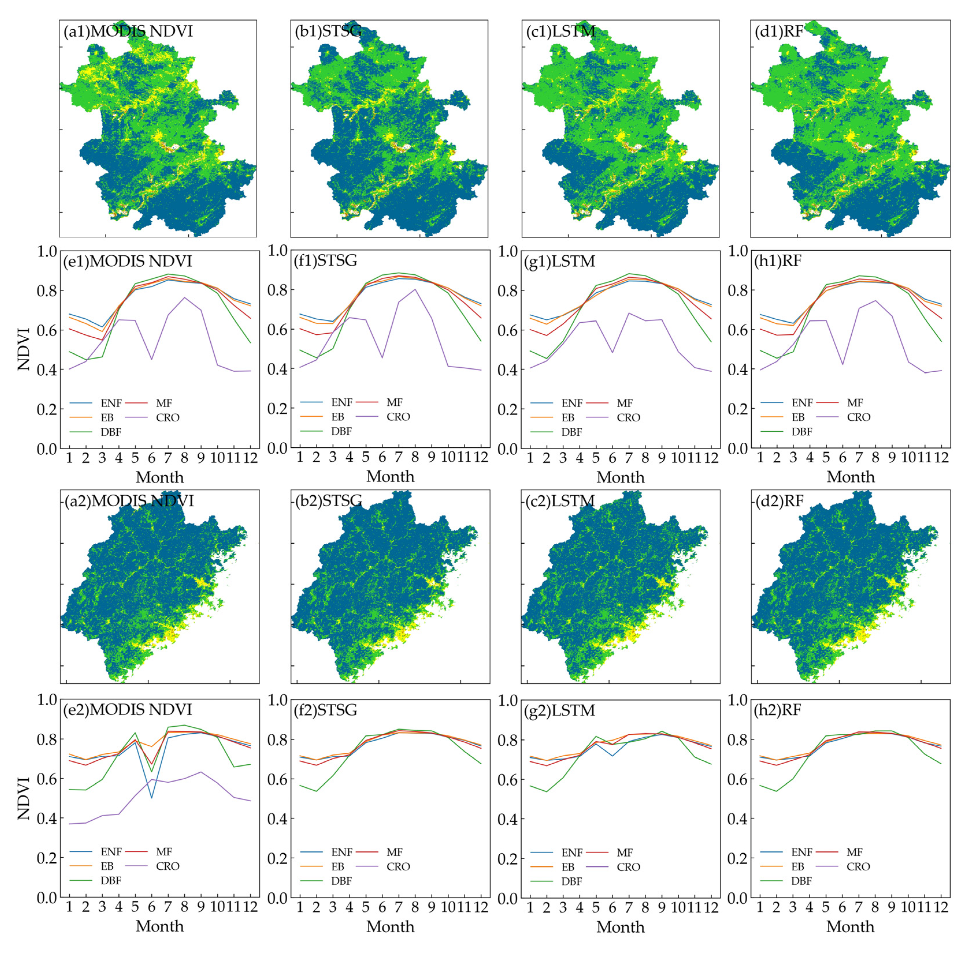
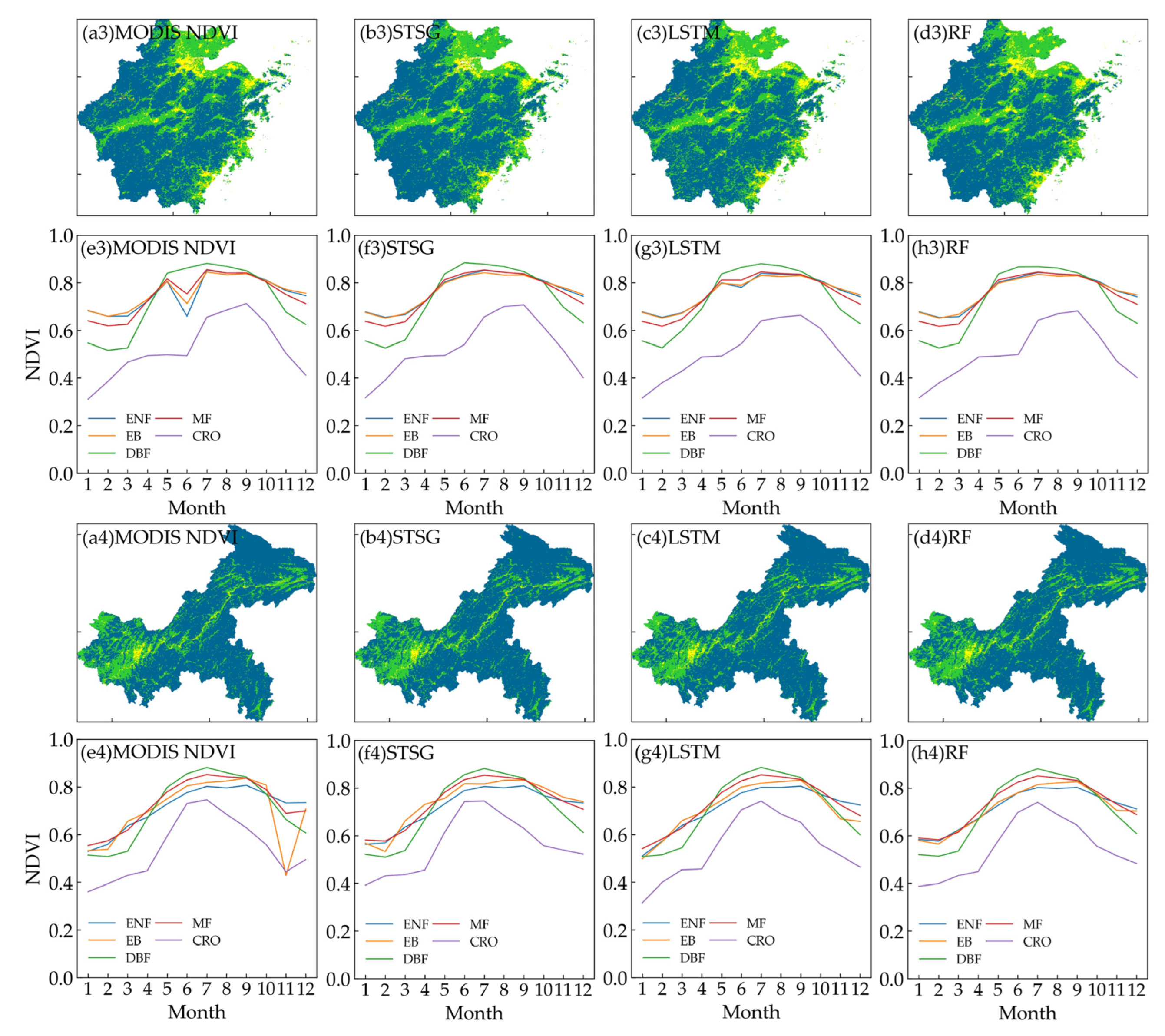
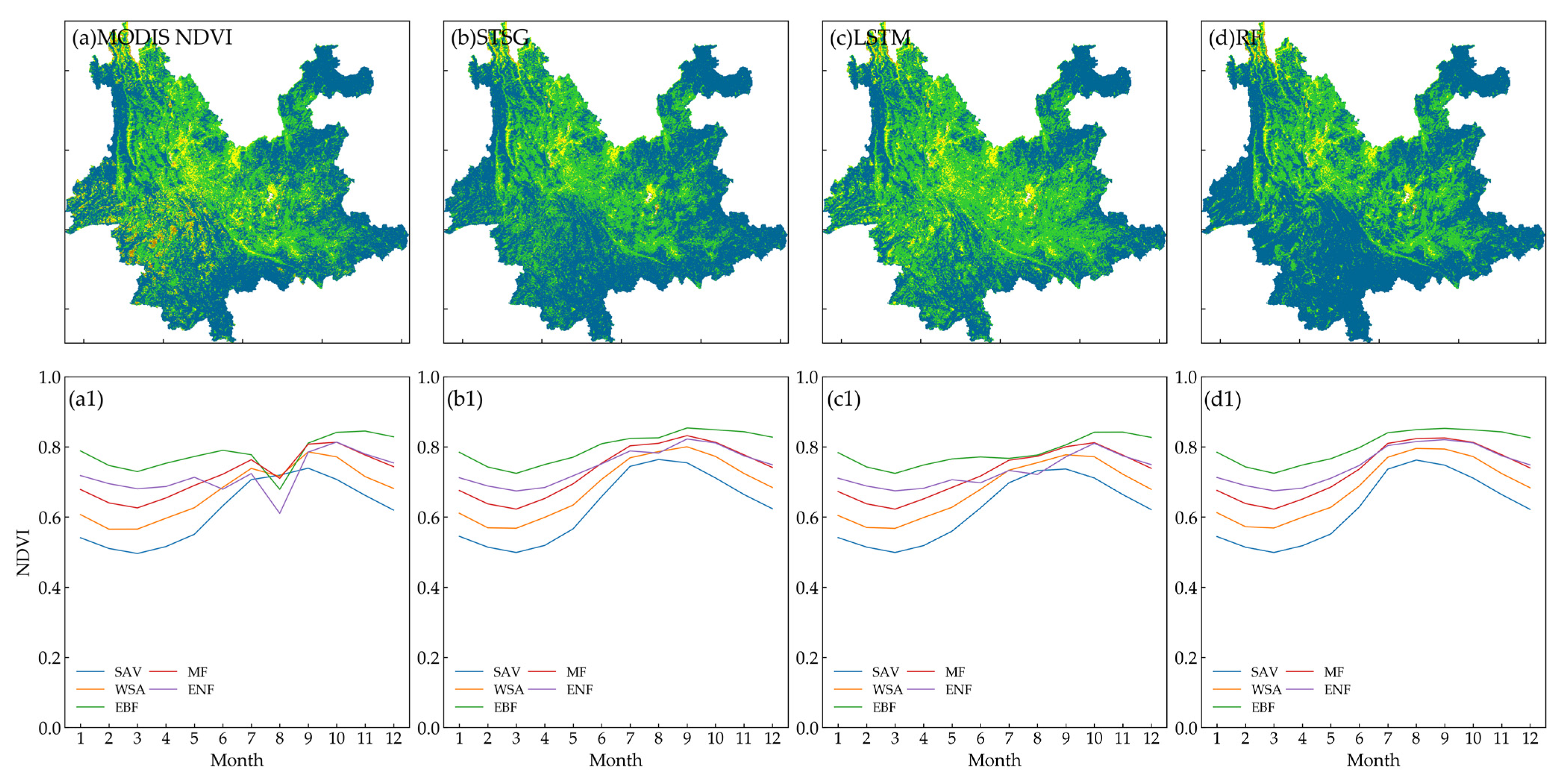
- By comparing the spatial pattern of different models, we found that the RF method could produce a product with more continuous spatial textures.
Author Contributions
Funding
Data Availability Statement
Conflicts of Interest
References
- Matsushita, B.; Yang, W.; Chen, J.; Onda, Y.C.; Qiu, G.Y. Sensitivity of the enhanced vegetation index (EVI) and normalised difference vegetation index (NDVI) to topographic effects: A case study in high-density cypress forest. Sensors 2007, 7, 2636–2651. [Google Scholar] [CrossRef] [PubMed]
- Kumari, N.; Saco, P.M.; Rodriguez, J.F.; Johnstone, S.A.; Srivastava, A.; Chun, K.P.; Yetemen, O. The grass is not always greener on the other side: Seasonal reversal of vegetation greenness in aspect-driven semiarid ecosystems. Geophys. Res. Lett. 2020, 47, e2020GL088918. [Google Scholar] [CrossRef]
- Chu, H.S.; Venevsky, S.; Wu, C.; Wang, M.H. NDVI-based vegetation dynamics and its response to climate changes at Amur-Heilongjiang River Basin from 1982 to 2015. Sci. Total Environ. 2019, 650, 2051–2062. [Google Scholar] [CrossRef] [PubMed]
- Zhao, J.; Huang, S.Z.; Huang, Q.; Wang, H.; Leng, G.Y.; Fang, W. Time-lagged response of vegetation dynamics to climatic and teleconnection factors. Catena 2020, 189, 104474. [Google Scholar] [CrossRef]
- Hu, T.; Myers Toman, E.; Chen, G.; Shao, G.; Zhou, Y.; Li, Y.; Zhao, K.; Feng, Y. Mapping fine-scale human disturbances in a working landscape with Landsat time series on Google Earth Engine. ISPRS J. Photogramm. Remote Sens. 2021, 176, 250–261. [Google Scholar] [CrossRef]
- Mao, Y.J.; Van Niel, T.G.; McVicar, T.R. Reconstructing cloud-contaminated NDVI images with SAR-Optical fusion using spatio-temporal partitioning and multiple linear regression. ISPRS J. Photogramm. Remote Sens. 2023, 198, 115–139. [Google Scholar] [CrossRef]
- Michishita, R.; Jin, Z.Y.; Chen, J.; Xu, B. Empirical comparison of noise reduction techniques for NDVI time-series based on a new measure. ISPRS J. Photogramm. Remote Sens. 2014, 91, 17–28. [Google Scholar] [CrossRef]
- Shao, Y.; Lunetta, R.S.; Wheeler, B.; Iiames, J.S.; Campbell, J.B. An evaluation of time-series smoothing algorithms for land-cover classifications using MODIS-NDVI multi-temporal data. Remote Sens. Environ. 2016, 174, 258–265. [Google Scholar] [CrossRef]
- Hird, J.N.; McDermid, G.J. Noise reduction of NDVI time series: An empirical comparison of selected techniques. Remote Sens. Environ. 2009, 113, 248–258. [Google Scholar] [CrossRef]
- Chen, J.; Jönsson, P.; Tamura, M.; Gu, Z.; Matsushita, B.; Eklundh, L. A simple method for reconstructing a high-quality NDVI time-series data set based on the Savitzky–Golay filter. Remote Sens. Environ. 2004, 91, 332–344. [Google Scholar] [CrossRef]
- Ma, M.; Veroustraete, F. Reconstructing pathfinder AVHRR land NDVI time-series data for the Northwest of China. Adv. Space Res. 2006, 37, 835–840. [Google Scholar] [CrossRef]
- Tang, L.; Zhao, Z.M.; Tang, P.; Yang, H.J. SURE-based optimum- length S-G filter to reconstruct NDVI time series iteratively with outliers removal. Int. J. Wavel. Multiresolut. Inf. Process. 2020, 18, 2050001. [Google Scholar] [CrossRef]
- Jonsson, P.; Eklundh, L. Seasonality extraction by function fitting to time-series of satellite sensor data. IEEE Trans. Geosci. Remote Sens. 2002, 40, 1824–1832. [Google Scholar] [CrossRef]
- Beck, P.S.; Atzberger, C.; Høgda, K.A.; Johansen, B.; Skidmore, A.K. Improved monitoring of vegetation dynamics at very high latitudes: A new method using MODIS NDVI. Remote Sens. Environ. 2006, 100, 321–334. [Google Scholar] [CrossRef]
- Liu, R.G.; Shang, R.; Liu, Y.; Lu, X.L. Global evaluation of gap-filling approaches for seasonal NDVI with considering vegeta-tion growth trajectory, protection of key point, noise resistance and curve stability. Remote Sens. Environ. 2017, 189, 164–179. [Google Scholar] [CrossRef]
- Yang, Y.P.; Luo, J.C.; Huang, Q.T.; Wu, W.; Sun, Y.W. Weighted double-logistic function fitting method for reconstructing the high-quality Sentinel-2 NDVI time series data set. Remote Sens. 2019, 11, 18. [Google Scholar] [CrossRef]
- Li, X.H.; Shen, R.P.; Chen, R.X. Improving time series reconstruction by fixing invalid values and its fidelity evaluation. IEEE Access 2020, 8, 7558–7572. [Google Scholar] [CrossRef]
- Xu, L.L.; Li, B.L.; Yuan, Y.C.; Gao, X.Z.; Zhang, T. A temporal-spatial iteration method to reconstruct NDVI time series datasets. Remote Sens. 2015, 7, 8906–8924. [Google Scholar] [CrossRef]
- Chu, D.; Shen, H.; Guan, X.; Chen, J.M.; Li, X.; Li, J.; Zhang, L. Long time-series NDVI reconstruction in cloud-prone regions via spatio-temporal tensor completion. Remote Sens. Environ. 2021, 264, 112632. [Google Scholar] [CrossRef]
- Cao, R.; Chen, Y.; Shen, M.; Chen, J.; Zhou, J.; Wang, C.; Yang, W. A simple method to improve the quality of NDVI time-series data by integrating spatiotemporal information with the Savitzky-Golay filter. Remote Sens. Environ. 2018, 217, 244–257. [Google Scholar] [CrossRef]
- Graves, A.; Graves, A. Long short-term memory. In Supervised Sequence Labelling with Recurrent Neural Networks; Springer: Berlin/Heidelberg, Germany, 2012; pp. 37–45. [Google Scholar]
- Li, S.; Xu, L.; Jing, Y.H.; Yin, H.; Li, X.H.; Guan, X.B. High-quality vegetation index product generation: A review of NDVI time series reconstruction techniques. Int. J. Appl. Earth Obs. Geoinf. 2021, 105, 102640. [Google Scholar] [CrossRef]
- Do Thi, N.; Pham, V.D.; Bui, Q.T.; Pham, V.M. Study Model for Information Reconstruction on Cloud Contaminated Area for Single Multispectral Remote Sensing Sentinel-2 Imagery using Generative Adversarial Network. VNU J. Sci. Earth Environ. Sci. 2022, 38, 32–44. [Google Scholar]
- Liu, H.; Huang, B.; Cai, J.J. Thick Cloud Removal under Land Cover Changes Using Multisource Satellite Imagery and a Spatiotemporal Attention Network. IEEE Trans. Geosci. Remote Sens. 2023, 61, 1–18. [Google Scholar] [CrossRef]
- Zhang, H.; Ma, J.Y.; Chen, C.; Tian, X. NDVI-Net: A fusion network for generating high-resolution normalized difference vegetation index in remote sensing. ISPRS J. Photogramm. Remote Sens. 2020, 168, 182–196. [Google Scholar] [CrossRef]
- Li, X.Q.; Yuan, W.P.; Dong, W.J. A machine learning method for predicting vegetation indices in China. Remote Sens. 2021, 13, 1147. [Google Scholar] [CrossRef]
- Roy, B. Optimum machine learning algorithm selection for forecasting vegetation indices: MODIS NDVI & EVI. Remote Sens. Appl. Soc. Environ. 2021, 23, 100582. [Google Scholar]
- Padhee, S.K.; Dutta, S. Spatiotemporal reconstruction of MODIS land surface temperature with the help of GLDAS product using kernel-based nonparametric data assimilation. J. Appl. Remote Sens. 2020, 14, 18. [Google Scholar] [CrossRef]
- Zheng, B.J.; Myint, S.W.; Thenkabail, P.S.; Aggarwal, R.M. A support vector machine to identify irrigated crop types using time-series Landsat NDVI data. Int. J. Appl. Earth Obs. Geoinf. 2015, 34, 103–112. [Google Scholar] [CrossRef]
- Ng, M.K.; Yuan, Q.Q.; Yan, L.; Sun, J. An Adaptive Weighted Tensor Completion Method for the Recovery of Remote Sensing Images with Missing Data. IEEE Trans. Geosci. Remote Sens. 2017, 55, 3367–3381. [Google Scholar] [CrossRef]
- Zhu, X.L.; Helmer, E.H. An automatic method for screening clouds and cloud shadows in optical satellite image time series in cloudy regions. Remote Sens. Environ. 2018, 214, 135–153. [Google Scholar] [CrossRef]
- Malamiri, H.R.G.; Zare, H.; Rousta, I.; Olafsson, H.; Verdiguier, E.I.; Zhang, H.; Mushore, T.D. Comparison of harmonic analysis of time series (HANTS) and multi-singular spectrum analysis (M-SSA) in reconstruction of long-gap missing data in NDVI time series. Remote Sens. 2020, 12, 22. [Google Scholar]
- Feng, Y.B.; Liu, Q.; Qu, Y.; Liang, S.L. Estimation of the Ocean Water Albedo from Remote Sensing and Meteorological Reanalysis Data. IEEE Trans. Geosci. Remote Sens. 2016, 54, 850–868. [Google Scholar] [CrossRef]
- Yao, Y.J.; Liang, S.L.; Li, X.L.; Hong, Y.; Fisher, J.B.; Zhang, N.N.; Chen, J.Q.; Cheng, J.; Zhao, S.H.; Zhang, X.T.; et al. Bayesian multimodel estimation of global terrestrial latent heat flux from eddy covariance, meteorological, and satellite observations. J. Geophys. Res. Atmos. 2014, 119, 4521–4545. [Google Scholar] [CrossRef]
- Xiao, Z.Q.; Liang, S.L.; Sun, R.; Wang, J.D.; Jiang, B. Estimating the fraction of absorbed photosynthetically active radiation from the MODIS data based GLASS leaf area index product. Remote Sens. Environ. 2015, 171, 105–117. [Google Scholar] [CrossRef]
- Jia, K.; Liang, S.L.; Wei, X.Q.; Yao, Y.J.; Yang, L.Q.; Zhang, X.T.; Liu, D.Y. Validation of Global LAnd Surface Satellite (GLASS) fractional vegetation cover product from MODIS data in an agricultural region. Remote Sens. Lett. 2018, 9, 847–856. [Google Scholar] [CrossRef]
- Yuan, W.P.; Cai, W.W.; Xia, J.Z.; Chen, J.Q.; Liu, S.G.; Dong, W.J.; Merbold, L.; Law, B.; Arain, A.; Beringer, J. Global comparison of light use efficiency models for simulating terrestrial vegetation gross primary production based on the LaThuile database. Agric. For. Meteorol. 2014, 192, 108–120. [Google Scholar] [CrossRef]
- Xiao, Z.Q.; Liang, S.L.; Jiang, B. Evaluation of four long time-series global leaf area index products. Agric. For. Meteorol. 2017, 246, 218–230. [Google Scholar] [CrossRef]
- Gelaro, R.; Mccarty, W.; Suárez, M.J. The modern-era retrospective analysis for research and applications, version 2 (MERRA-2). J. Clim. 2017, 30, 5419–5454. [Google Scholar] [CrossRef]
- Simard, M.; Neumann, M.; Buckley, S. Validation of the New SRTM Digital Elevation Model (NASADEM) with ICESAT/GLAS over the United States. In Proceedings of the IEEE International Geoscience and Remote Sensing Symposium (IGARSS) 2016, Beijing, China, 10–15 July 2016; pp. 3227–3229. [Google Scholar]
- Zamani Joharestani, M.; Cao, C.; Ni, X.; Bashir, B.; Talebiesfandarani, S. PM2.5 prediction based on random forest, XGBoost, and deep learning using multisource remote sensing data. Atmosphere 2019, 10, 373. [Google Scholar] [CrossRef]
- Jui, S.J.J.; Ahmed, A.M.; Bose, A.; Raj, N.; Sharma, E.; Soar, J.; Chowdhury, M.W. Spatiotemporal hybrid random forest model for tea yield prediction using satellite-derived variables. Remote Sens. 2022, 14, 805. [Google Scholar] [CrossRef]
- Belgiu, M.; Drăguţ, L. Random forest in remote sensing: A review of applications and future directions. ISPRS J. Photogramm. Remote Sens. 2016, 114, 24–31. [Google Scholar] [CrossRef]
- Gibson, R.; Danaher, T.; Hehir, W.; Collins, L. A remote sensing approach to mapping fire severity in south-eastern Australia using sentinel 2 and random forest. Remote Sens. Environ. 2020, 240, 111702. [Google Scholar] [CrossRef]
- Adugna, T.; Xu, W.B.; Fan, J.L. Comparison of random forest and support vector machine classifiers for regional land cover mapping using coarse resolution FY-3C images. Remote Sens. 2022, 14, 574. [Google Scholar] [CrossRef]
- Breiman, L. Random forests. Mach. Learn. 2001, 45, 5–32. [Google Scholar] [CrossRef]
- Malhotra, P.; Vig, L.; Shroff, G.; Agarwal, P. Long Short Term Memory Networks for Anomaly Detection in Time Series. In Proceedings of the 23rd European Symposium on Artificial Neural Networks, Computational Intelligence and Machine Learning, ESANN 2015, Bruges, Belgium, 22–24 April 2015; p. 89. [Google Scholar]
- Reddy, D.S.; Prasad, P.R. Prediction of vegetation dynamics using NDVI time series data and LSTM. Model. Earth Syst. Environ. 2018, 4, 409–419. [Google Scholar] [CrossRef]
- Muruganantham, P.; Wibowo, S.; Grandhi, S.; Samrat, N.H.; Islam, N. A systematic literature review on crop yield prediction with deep learning and remote sensing. Remote Sens. 2022, 14, 1990. [Google Scholar] [CrossRef]
- Hochreiter, S.; Schmidhuber, J. Long short-term memory. Neural Comput. 1997, 9, 1735–1780. [Google Scholar] [CrossRef]
- Pan, S.; Zhao, X.W.; Yue, Y.J. Spatiotemporal changes of NDVI and correlation with meteorological factors in northern china from 1985–2015. In E3S Web of Conferences 2019; EDP Sciences: Les Ulis, France, 2019; Volume 131, p. 1040. [Google Scholar]
- Zhao, Q.Q.; Zhang, J.P.; Zhao, T.B.; Li, J.H. Vegetation changes and its response to climate change in China Since 2000. Plateau Meteorol. 2021, 40, 292–301. [Google Scholar]
- Li, F.; Song, G.; Liujun, Z.; Yanan, Z.; Di, L. Urban vegetation phenology analysis using high spatio-temporal NDVI time series. Urban For. Urban Green. 2017, 25, 43–57. [Google Scholar] [CrossRef]
- Cutler, A.; Cutler, D.R.; Stevens, J.R. Random forests. In Ensemble Machine Learning: Methods and Applications; Springer: Berlin/Heidelberg, Germany, 2012; pp. 157–175. [Google Scholar]
- Bryan, B.A.; Gao, L.; Ye, Y.Q.; Sun, X.F.; Connor, J.D.; Crossman, N.D.; Stafford-Smith, M.; Wu, J.G.; He, C.Y.; Yu, D.Y. China’s response to a national land-system sustainability emergency. Nature 2018, 559, 193–204. [Google Scholar] [CrossRef]
- Zastrow, M. China’s tree-planting could falter in a warming world. Nature 2019, 573, 474–475. [Google Scholar] [CrossRef] [PubMed]




| Data | Spatial Resolution | Time Resolution | Data Source |
|---|---|---|---|
| NDVI | 1 km | Monthly | MOD13A3 |
| Albedo (BSA VIS/WSA NIR/WSA SWIR/WSA VIS) | 1 km | Eight days | GLASS |
| ET | 1 km | Eight days | GLASS |
| FAPAR | 1 km | Eight days | GLASS |
| FVC | 1 km | Eight days | GLASS |
| GPP | 1 km | Eight days | GLASS |
| LAI | 1 km | Eight days | GLASS |
| Precipitation | 0.5° | Monthly | MERRA2 |
| Temperature | 0.5° | Monthly | MERRA2 |
| DEM | 30 m | NASADEM | |
| Longitude | 1 km | According to the longitude range of China | |
| Latitude | 1 km | According to the latitude range of China |
| STSG | LSTM | RF | |
|---|---|---|---|
| separability | 0.051 | 0.013 | 0.010 |
Disclaimer/Publisher’s Note: The statements, opinions and data contained in all publications are solely those of the individual author(s) and contributor(s) and not of MDPI and/or the editor(s). MDPI and/or the editor(s) disclaim responsibility for any injury to people or property resulting from any ideas, methods, instructions or products referred to in the content. |
© 2023 by the authors. Licensee MDPI, Basel, Switzerland. This article is an open access article distributed under the terms and conditions of the Creative Commons Attribution (CC BY) license (https://creativecommons.org/licenses/by/4.0/).
Share and Cite
Sun, M.; Gong, A.; Zhao, X.; Liu, N.; Si, L.; Zhao, S. Reconstruction of a Monthly 1 km NDVI Time Series Product in China Using Random Forest Methodology. Remote Sens. 2023, 15, 3353. https://doi.org/10.3390/rs15133353
Sun M, Gong A, Zhao X, Liu N, Si L, Zhao S. Reconstruction of a Monthly 1 km NDVI Time Series Product in China Using Random Forest Methodology. Remote Sensing. 2023; 15(13):3353. https://doi.org/10.3390/rs15133353
Chicago/Turabian StyleSun, Mengmeng, Adu Gong, Xiang Zhao, Naijing Liu, Longping Si, and Siqing Zhao. 2023. "Reconstruction of a Monthly 1 km NDVI Time Series Product in China Using Random Forest Methodology" Remote Sensing 15, no. 13: 3353. https://doi.org/10.3390/rs15133353
APA StyleSun, M., Gong, A., Zhao, X., Liu, N., Si, L., & Zhao, S. (2023). Reconstruction of a Monthly 1 km NDVI Time Series Product in China Using Random Forest Methodology. Remote Sensing, 15(13), 3353. https://doi.org/10.3390/rs15133353


