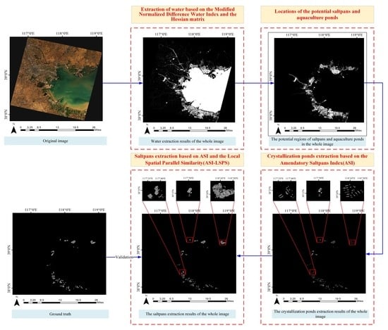
Automatic Extraction of Saltpans on an Amendatory Saltpan Index and Local Spatial Parallel Similarity in Landsat-8 Imagery
Abstract
1. Introduction
2. Materials and Methods
2.1. Study Areas
2.2. Data and Preprocessing
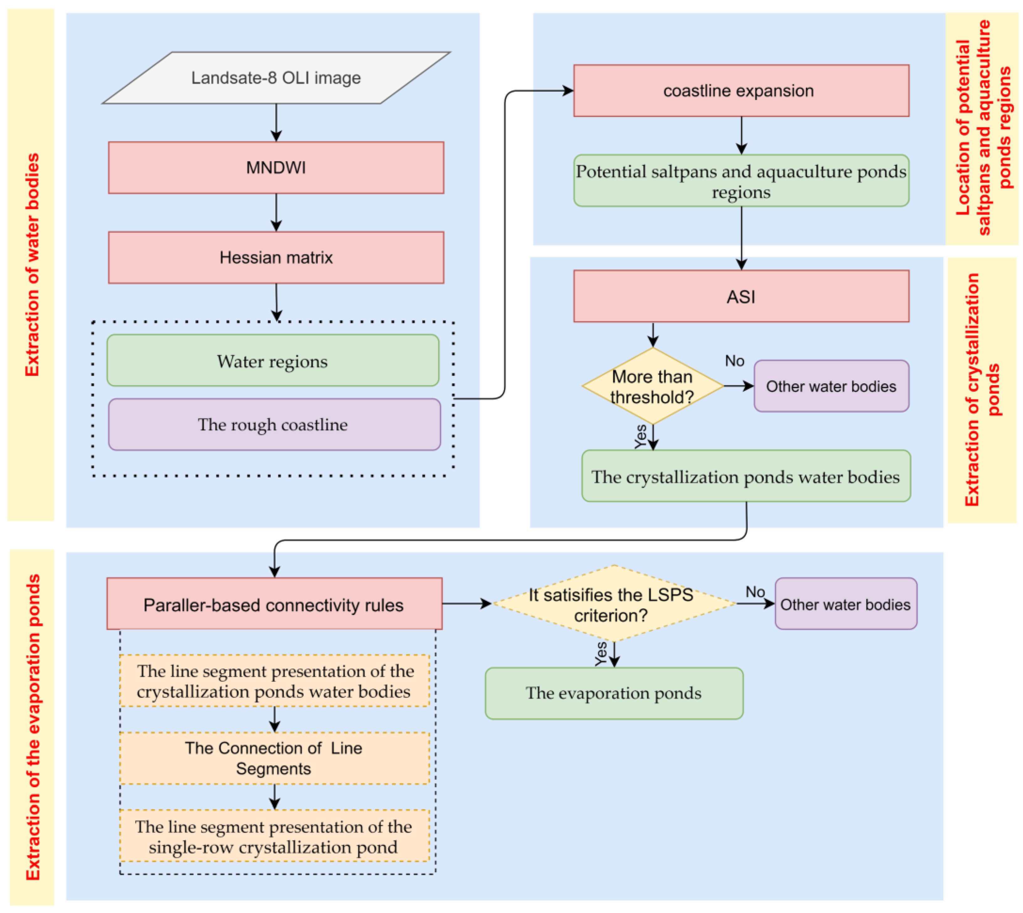
2.3. Methods
2.3.1. Extraction of Water Bodies
2.3.2. Location of Potential Saltpans and Aquaculture Ponds Regions
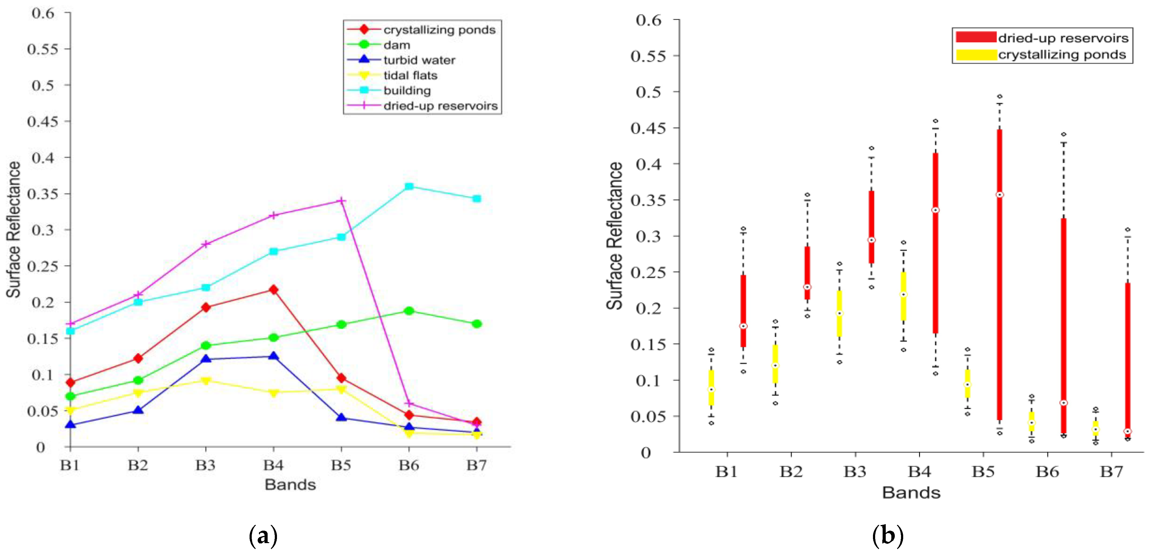
2.3.3. Extraction of Crystallization Ponds
2.3.4. Extraction of Evaporation Ponds
The Line Segment Presentation of a Single Crystallization Pond
The Connection of Parallel Line Segments
Evaporation Ponds Discrimination Criterion
2.3.5. Accuracy Assessment
3. Results
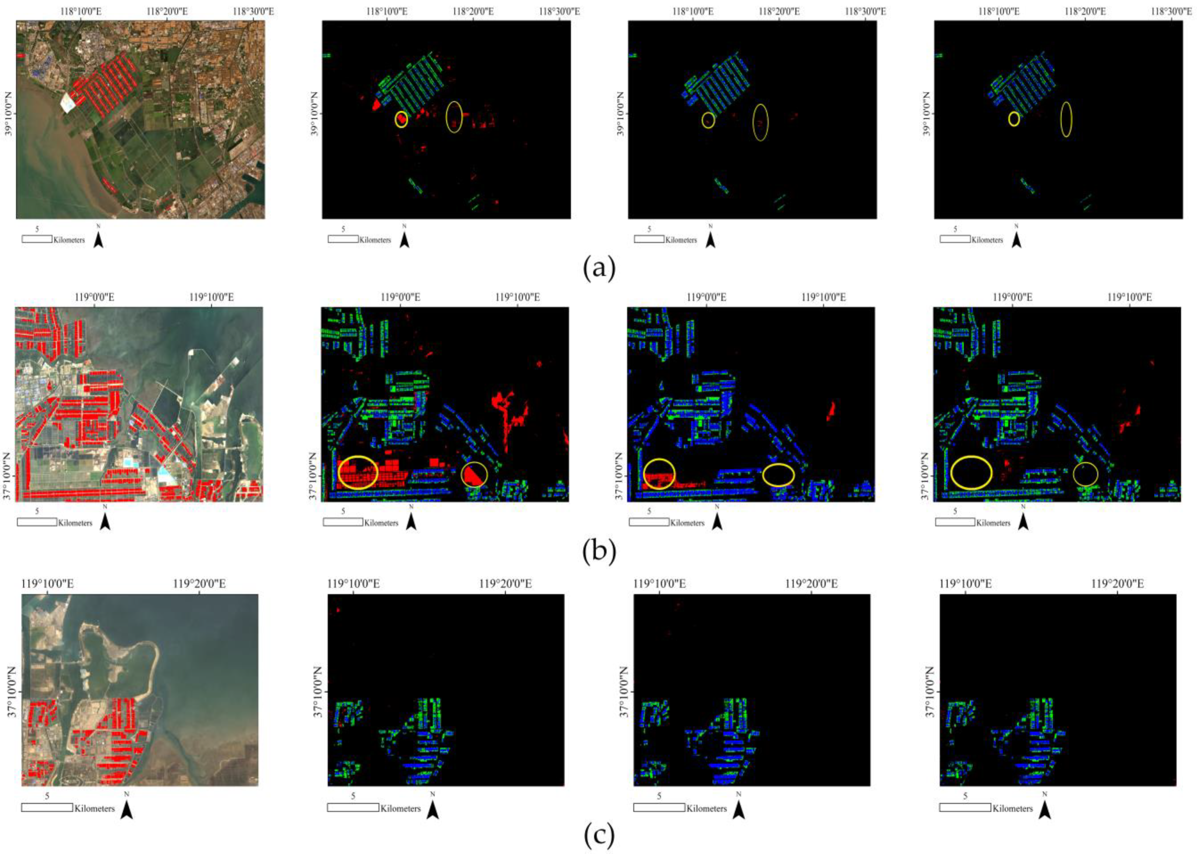
3.1. Extraction Performance Comparison of Crystallization Ponds
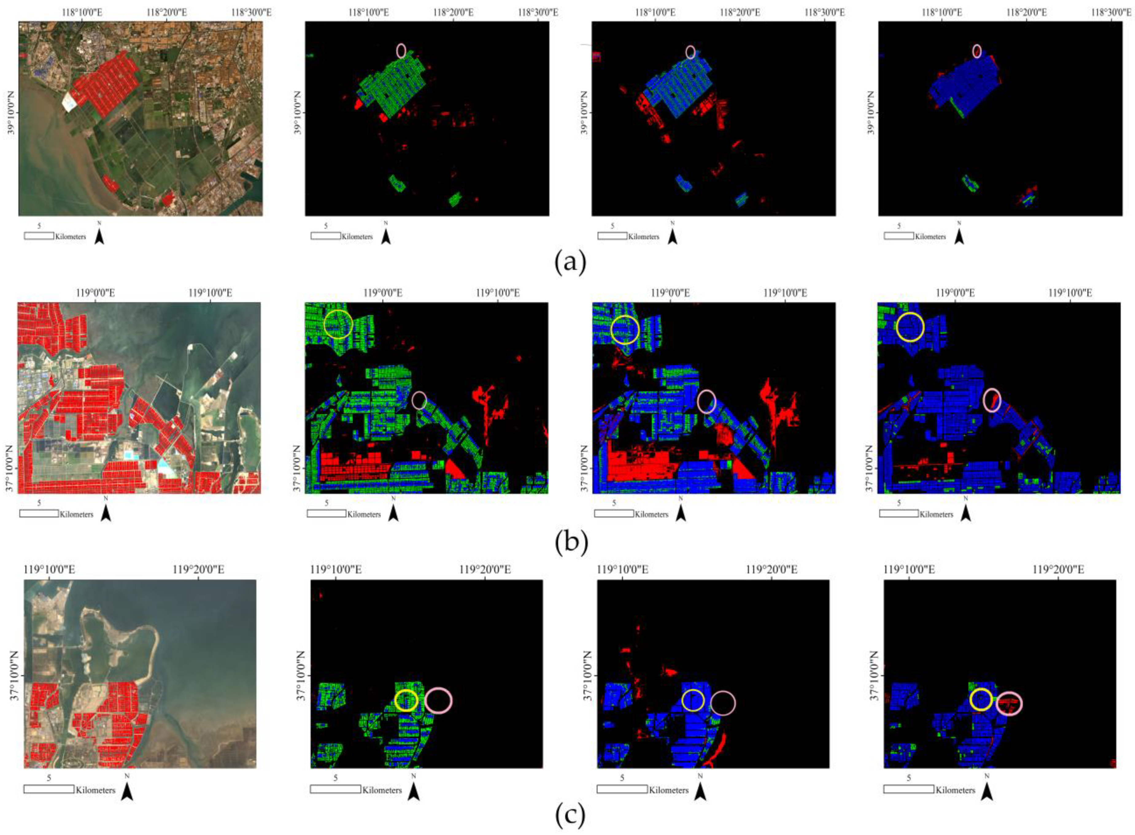
3.2. Performance Comparison of Saltpans Extraction
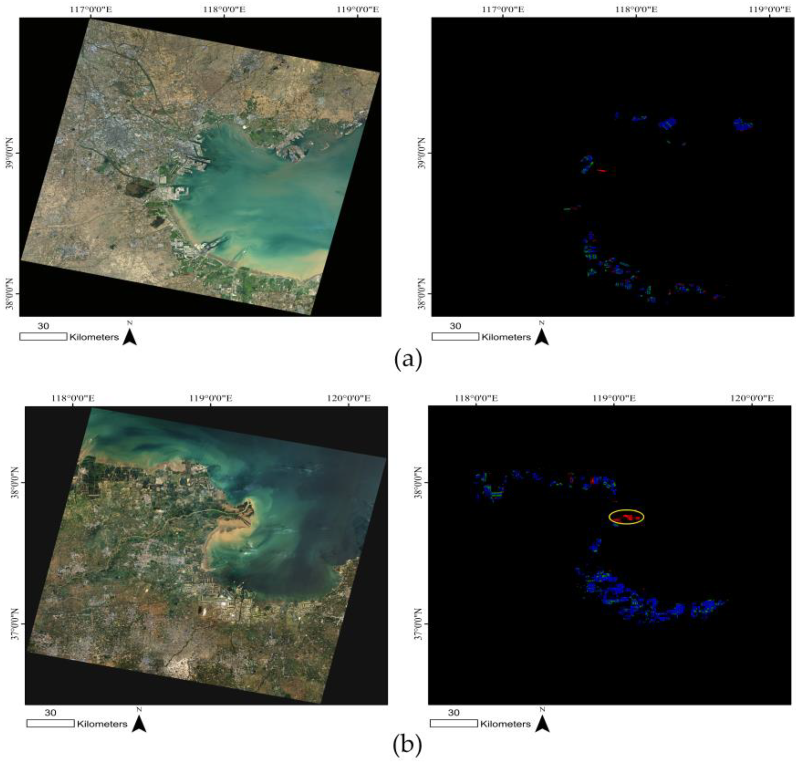
3.3. Extraction of Saltpans in the Whole Imagery
4. Discussion
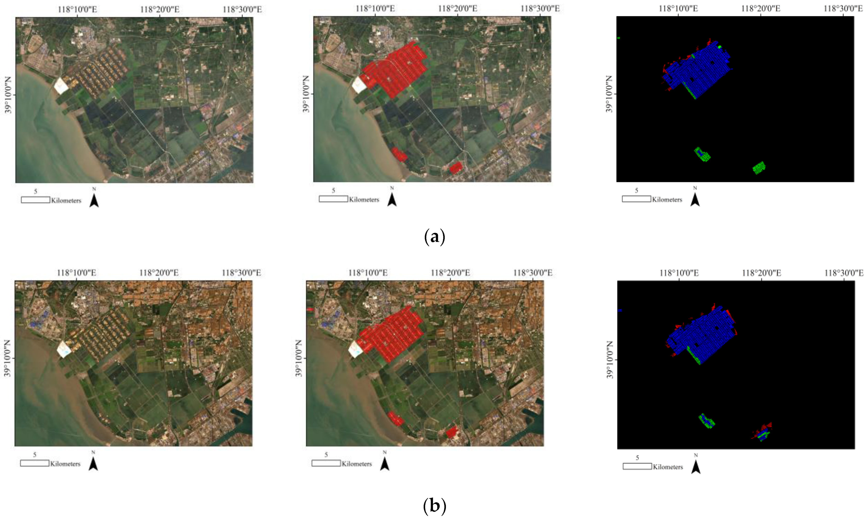
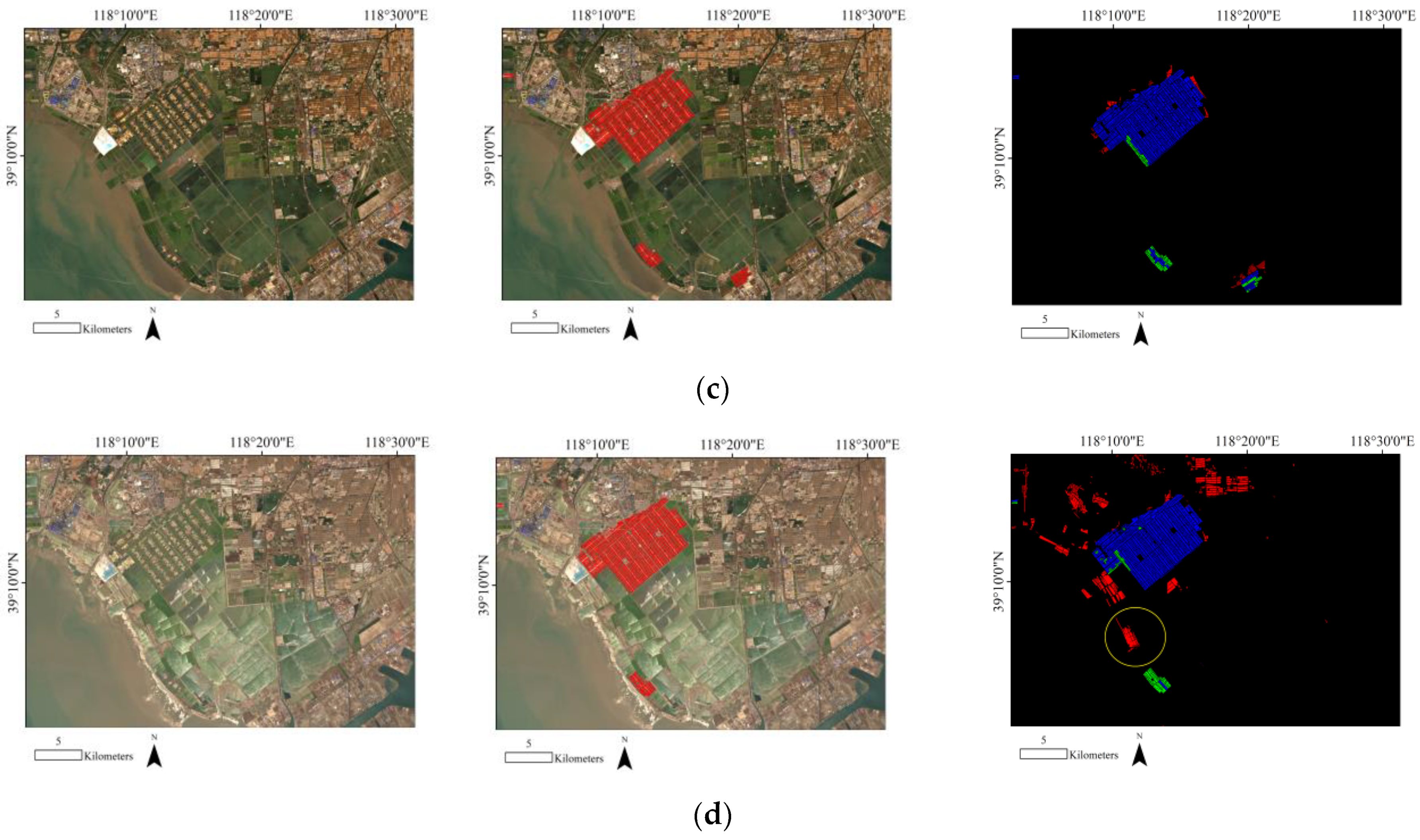
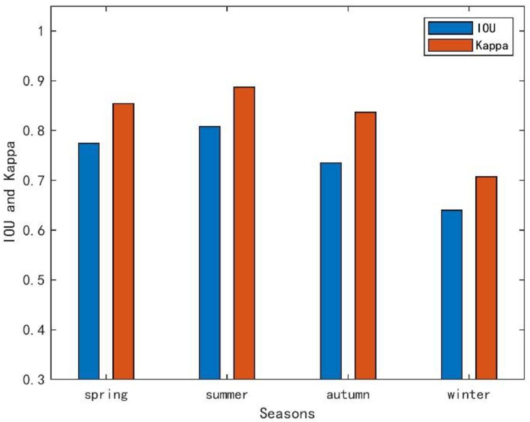
4.1. The Impact of Seasonal Changes on the Extraction of Saltpans
4.2. Advantages, Limitations, and Potential Improvements
4.2.1. Advantages
4.2.2. Limitations
5. Conclusions
Author Contributions
Funding
Data Availability Statement
Acknowledgments
Conflicts of Interest
References
- Oren, A. Saltern evaporation ponds as model systems for the study of primary production processes under hypersaline conditions. Aquat. Microb. Ecol. 2009, 56, 193–204. [Google Scholar] [CrossRef]
- Sridhar, P.N.; Surendran, A.; Ramana, I.V. Auto-extraction technique-based digital classification of saltpans and aquaculture plots using satellite data. Int. J. Remote Sens. 2008, 29, 313–323. [Google Scholar] [CrossRef]
- Wang, H.; Xu, X.G.; Zhu, G.R. Landscape Changes and a Salt Production Sustainable Approach in the State of Salt Pan Area Decreasing on the Coast of Tianjin, China. Sustainability 2015, 7, 10078–10097. [Google Scholar] [CrossRef]
- Bechor, B.; Sivan, D.; Miko, S.; Hasan, O.; Grisonic, M.; Radić Rossi, I.; Lorentzen, B.; Artioli, G.; Ricci, G.; Ivelja, T.; et al. Salt pans as a new archaeological sea-level proxy: A test case from Dalmatia, Croatia. Quat. Sci. Rev. 2020, 250, 106680. [Google Scholar] [CrossRef]
- Ri, P.V.; Stieglitz, T. Dry Season Salinity Changes in Arid Estuaries Fringed by Mangroves and Saltflats. Estuar. Coast. Shelf Sci. 2002, 54, 1039–1049. [Google Scholar]
- Albuquerque, A.M.; Ferreira, T.O.; Romero, R.E.; de Souza, V.S.; da Silva Júnior, C.A.B.; de Andrade Meireles, A.J.; Otero, X.L. Soil genesis on hypersaline tidal flats (apicum ecosystem) in a tropical semi-arid estuary (Ceará, Brazil). Soil Res. 2014, 52, 140. [Google Scholar] [CrossRef]
- Velasquez, C.R. Managing Artificial saltpans as a Waterbird Habitat: Species’ Responses to Water Level Manipulation. Colon. Waterbirds 1992, 15, 43–55. [Google Scholar] [CrossRef]
- Takekawa, J.Y.; Miles, A.K.; Schoellhamer, D.H.; Athearn, N.D.; Saiki, M.K.; Duffy, W.D.; Kleinschmidt, S.; Shellenbarger, G.; Jannusch, C.A. Trophic Structure and Avian Communities across a Salinity Gradient in Evaporation Ponds of the San Francisco Bay Estuary. Hydrobiologia 2006, 567, 307–327. [Google Scholar] [CrossRef]
- Giosa, E.; Mammides, C.; Zotos, S. The importance of artificial wetlands for birds: A case study from Cyprus. PLoS ONE 2018, 13, e0197286. [Google Scholar] [CrossRef]
- Cao, K.; Ma, H.W.; Sun, A.N. Analysis of spatial pattern for coastal salt pond engineer based on high spatial resolution satellite remote sensing imagery:a case study in south coast of Yingkou. J. Appl. Oceanogr. 2017, 36, 286–294. [Google Scholar]
- Wang, J.J.; Zhang, Y.; Tao, F. The Research and Application of the Salt Pan Water Area Classfication Method by Meams of Remote Sensing Classification of Saltpan Water. Ocean Technol. 2005, 24, 67–71. [Google Scholar]
- Arvor, D.; Daher, F.R.G.; Briand, D.; Dufour, S.; Rollet, A.; Simoes, M.; Ferraz, R. Monitoring thirty years of small water reservoirs proliferation in the southern Brazilian Amazon with Landsat time series. ISPRS J. Photogramm. Remote Sens. 2018, 145, 225–237. [Google Scholar] [CrossRef]
- Roy, D.P.; Wulder, M.A.; Loveland, T.R.; Woodcock, C.E.; Allen, R.G.; Anderson, M.C.; Helder, D.; Irons, J.; Johnson, D.; Kennedy, R.; et al. Landsat-8: Science and product vision for terrestrialglobal change research. Remote Sens. Environ. 2014, 145, 154–172. [Google Scholar] [CrossRef]
- Anshuman, B.; Joshi, P.; Snehmani, L.S.; Mritunjay, K.S.; Shaktiman, S.; Rajesh, K. Applicability of landsat8 data for char-acterizing glacier facies and supraglacial debris. Int. J. Appl. Earth Obs. Geoinf. 2015, 38, 51–64. [Google Scholar]
- Hu, P.X.; Zhang, Y.; Wang, J.H. Principal component fusion-based classification of salt field water bodies with remote sensing technique. J. Hohai Univ. Nat. Sci. 2004, 5, 519–522. [Google Scholar]
- Zhang, X.K. The Artificial Neural Network and Its Research on Classifying in Remote Sensing Image of Salt Fields Water. J. Salt Chem. Ind. 2006, 4, 40–43. [Google Scholar]
- Yu, Y.G.; Ma, Y. Spot-5 image marks for interpreting the types of land use/cover in the coastal zone of the Jiaozhou Bay. Coast. Eng. 2011, 30, 61–70. [Google Scholar]
- Lorenz, C.; Carlsen, I.; Buzug, T.M.; Fassnacht, C.; Weese, J. Multi-scale line segmentation with automatic estimation of width, contrast and tangential direction in 2D and 3D medical images. In Proceedings of the First Joint Conference, Computer Vision, Virtual Reality and Robotics in Medicine and Medical Robotics and Computer-Assisted Surgery, Grenoble, France, 19–22 March 1997; Springer: Berlin/Heidelberg, Germany, 1997; pp. 233–242. [Google Scholar]
- Liu, X.H.; Liu, L.; Peng, Y. Ecological zoning for regional sustainable development using an integrated modeling approach in the Bohai Rim. China. Ecol. Model. 2017, 353, 158–166. [Google Scholar] [CrossRef]
- Xie, L.; Zhang, H.; Wang, C.; Chen, F. Water-Body types identification in urban areas from radarsat-2 fully polarimetric SAR data. Int. J. Appl. Earth Obs. Geoinf. 2016, 50, 10–25. [Google Scholar] [CrossRef]
- Zhao, H.; Chen, F.; Zhang, M. A Systematic Extraction Approach for Mapping Glacial Lakes in High Mountain Regions of Asia. IEEE J. Sel. Top. Appl. Earth Obs. Remote Sens. 2018, 11, 2788–2799. [Google Scholar] [CrossRef]
- Zhang, G.; Zheng, G.; Gao, Y.; Xiang, Y.; Lei, Y.; Li, J. Automated water classification in the Tibetan Plateau using Chinese GF-1 WFV data. Photogramm. Eng. Remote Sens. 2007, 83, 33–43. [Google Scholar] [CrossRef]
- Feyisa, G.L.; Meilby, H.; Fensholt, R.; Proud, S.R. Automated Water Extraction Index: A new technique for surface water mapping using Landsat imagery. Remote Sens. Environ. 2014, 140, 23–35. [Google Scholar] [CrossRef]
- Mcfeeters, S.K. The use of the Normalized Difference Water Index (NDWI) in the delineation of open water features. Int. J. Remote Sens. 1996, 17, 1425–1432. [Google Scholar] [CrossRef]
- Aylward, S.R.; Bullitt, E. Initialization, Noise, Singularities, and Scale in Height Ridge Traversal for Tubular Object Centerline Extraction. IEEE Trans. Med. Imaging 2002, 21, 61–75. [Google Scholar] [CrossRef] [PubMed]
- Sun, Z.; Luo, J.; Yang, J.; Yu, Q.; Zhang, L.; Xue, K.; Lu, L. Nation-Scale Mapping of Coastal Aquaculture Ponds with Sentinel-1 SAR Data Using Google Earth Engine. Remote Sens. 2020, 12, 3086. [Google Scholar] [CrossRef]
- Xia, G.; Delon, J.; Gousseau, Y. Shape-based Invariant Texture Indexing. Int. J. Comput. Vis. 2010, 88, 382–403. [Google Scholar] [CrossRef]
- Richards, J.A. Image Classification in Practice. In Remote Sensing Digital Image Analysis; Springer: Berlin/Heidelberg, Germany, 2013; pp. 381–435. [Google Scholar]
- Shi, T.Y.; Zou, Z.; Shi, Z.; Chu, J.; Zhao, J.; Gao, N.; Zhang, N.; Zhu, X. Mudflat aquaculture labeling for infrared remote sensing images via a scanning convolutional network. Infrared Phys. Technol. 2018, 94, 16–22. [Google Scholar] [CrossRef]
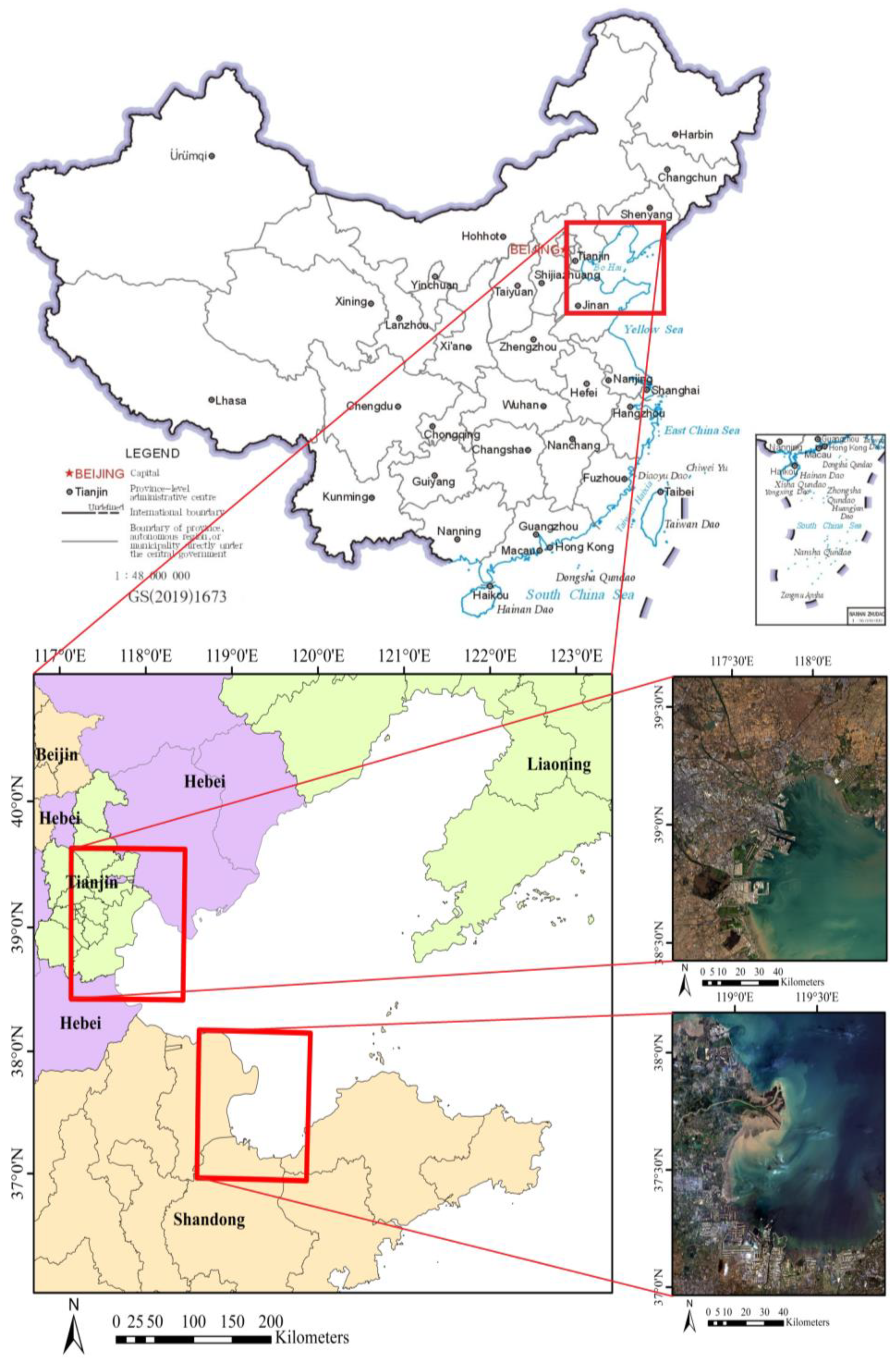
| Study Area | Landsat-8 Scene ID | Path/Row | Data Acquisition | Cloud Cover | Site Center | Major Types of Landscapes |
|---|---|---|---|---|---|---|
| a | LC81220332019302LGN00 | 122/33 | 28 October 2019 | 1.06% | 38°55′52.04″N, 117°53′1.88″E | Saltpans, aquaculture ponds, vegetation, artificial buildings, and mangrove forests |
| LC81220332019014LGN00 | 122/33 | 14 January 2019 | 0.55% | 38°55′52.04″N, 117°53′1.88″E | ||
| LC81220332019078LGN00 | 122/33 | 19 April 2019 | 4.1% | 38°55′52.04″N, 117°53′1.88″E | ||
| LC81220332019270LGN00 | 122/33 | 27 September 2019 | 2.96% | 38°55′52.04″N, 117°53′1.88″E | ||
| LC81220332019318LGN00 | 122/33 | 14 November 2019 | 3.24% | 38°55′52.04″N, 117°53′1.88″E | ||
| b | LC81210342019199LGN00 | 121/34 | 18 July 2019 | 9.43% | 37°29′33.75″N, 118°59′47.89″E | Saltpans, aquaculture ponds, bare ground, artificial buildings, vegetation, and crops |
| Study Regions | ASI | NDSI | ZBP | |||
|---|---|---|---|---|---|---|
| IOU (%) | Kappa (%) | IOU (%) | Kappa (%) | IOU (%) | Kappa (%) | |
| a | 0.7175 | 0.8091 | 0.5828 | 0.6631 | 0.7023 | 0.7914 |
| b | 0.7051 | 0.7853 | 0.5943 | 0.6845 | 0.6809 | 0.7712 |
| c | 0.7365 | 0.8381 | 0.6566 | 0.7788 | 0.7295 | 0.7953 |
| Study Regions | ASI-LSPS | NDSI | HPCA | |||
|---|---|---|---|---|---|---|
| IOU (%) | Kappa (%) | IOU (%) | Kappa (%) | IOU (%) | Kappa (%) | |
| a | 0.8567 | 0.8916 | 0.5442 | 0.6235 | 0.6011 | 0.6521 |
| b | 0.8236 | 0.8969 | 0.5123 | 0.5964 | 0.6609 | 0.7183 |
| c | 0.8462 | 0.9096 | 0.5556 | 0.6702 | 0.7095 | 0.7353 |
Disclaimer/Publisher’s Note: The statements, opinions and data contained in all publications are solely those of the individual author(s) and contributor(s) and not of MDPI and/or the editor(s). MDPI and/or the editor(s) disclaim responsibility for any injury to people or property resulting from any ideas, methods, instructions or products referred to in the content. |
© 2023 by the authors. Licensee MDPI, Basel, Switzerland. This article is an open access article distributed under the terms and conditions of the Creative Commons Attribution (CC BY) license (https://creativecommons.org/licenses/by/4.0/).
Share and Cite
Jiao, X.; Shi, X.; Shen, Z.; Ni, K.; Deng, Z. Automatic Extraction of Saltpans on an Amendatory Saltpan Index and Local Spatial Parallel Similarity in Landsat-8 Imagery. Remote Sens. 2023, 15, 3413. https://doi.org/10.3390/rs15133413
Jiao X, Shi X, Shen Z, Ni K, Deng Z. Automatic Extraction of Saltpans on an Amendatory Saltpan Index and Local Spatial Parallel Similarity in Landsat-8 Imagery. Remote Sensing. 2023; 15(13):3413. https://doi.org/10.3390/rs15133413
Chicago/Turabian StyleJiao, Xiangyu, Xiaofei Shi, Ziyang Shen, Kuiyuan Ni, and Zhiyu Deng. 2023. "Automatic Extraction of Saltpans on an Amendatory Saltpan Index and Local Spatial Parallel Similarity in Landsat-8 Imagery" Remote Sensing 15, no. 13: 3413. https://doi.org/10.3390/rs15133413
APA StyleJiao, X., Shi, X., Shen, Z., Ni, K., & Deng, Z. (2023). Automatic Extraction of Saltpans on an Amendatory Saltpan Index and Local Spatial Parallel Similarity in Landsat-8 Imagery. Remote Sensing, 15(13), 3413. https://doi.org/10.3390/rs15133413


