1. Introduction
A polarimetric synthetic aperture radar (PolSAR) can acquire images with high resolution full-time and in all weather [
1,
2]. In the event of disasters and wars, PolSAR has timely and effective ground-mapping capabilities [
3,
4]. Using polarimetry, four polarizations (HH, VV, HV, and VH) are used to illuminate the ground targets, making them sensitive to the shape, orientation, and dielectric properties of illuminated targets and capable of distinguishing different targets [
5,
6,
7,
8,
9,
10,
11,
12,
13,
14,
15].
To effectively classify ground targets from PolSAR images, it is necessary to understand the PolSAR scattering process [
16]. To this end, PolSAR decomposition technology has been widely used to interpret the scattering process by decomposing the PolSAR coherency matrix into several scattering matrices related to the geometrical and physical characteristics of ground targets. Currently, PolSAR decomposition includes coherent target decomposition [
17,
18,
19] and incoherent target decomposition [
20,
21,
22,
23]. The former is mainly suitable for analyzing deterministic targets, while the latter can be used to investigate the scattering process of distributed targets and has received widespread attention [
24]. In particular, model-based decomposition, as an incoherent decomposition, plays an important role in land cover classification [
25,
26,
27,
28,
29,
30,
31].
In 1998, Freeman–Durden decomposition was proposed by Freeman and Durden, which decomposes the scattering process of the land cover into surface scattering caused by micro-rough surfaces, double-bounce scattering generated from two mutually perpendicular planes, and volume scattering induced by random dipoles [
20]. Although Freeman–Durden decomposition can effectively describe the scattering process of natural media based on the assumption of reflection symmetry, only some of the elements in the PolSAR coherency matrix are used to interpret the scattering process. In this case, for the oriented buildings that do not satisfy reflection symmetry, the corresponding scattering signals are also recorded by the PolSAR coherency matrix, which cannot be interpreted by the Freeman–Durden scattering model. As a result, the misclassification of oriented buildings and vegetation is significant since the volume scattering contribution from oriented buildings is strong and similar to that of vegetation. To solve this problem, the non-reflection symmetry elements in the PolSAR coherency matrix should be considered in a model-based decomposition.
There are two types of methods that can be used to describe the scattering process following non-reflection symmetry, including scattering model-based and polarimetric orientation rotation methods. Yamaguchi et al. first introduced the helix scattering model to describe the scattering process linked to the imaginary part of
, which can absorb some scattering power of the HV channel and reduce the overestimation of volume scattering contribution from oriented buildings to some degree [
32]. In the following studies, the most representative scattering model to absorb the scattering components following non-reflection symmetry was proposed by Singh et al., including the six- and seven-component decomposition models [
33,
34]. Compared with the Freeman–Durden scattering model, Singh’s model can effectively reduce the overestimation of the volume scattering contribution from the oriented building area. In contrast to the above scattering models, the methods based on polarimetric orientation rotation interpret the scattering process following non-reflection symmetry by rotating the PolSAR coherency matrix. A reflection symmetry algorithm is proposed by An et al. [
35], in which the polarimetric orientation angle (POA) is used to rotate the PolSAR coherency matrix so that the real part of
can be changed to zero [
35,
36,
37,
38]. The helix angle (HA) corresponding to the imaginary part of
is then used to rotate the PolSAR coherency matrix. Finally, the
is rotated to zero by a further 45° POA rotation. In such a case, the
term has been minimized as much as possible, which reduces the misclassification of oriented buildings and forests, and the corresponding scattering process recorded by the PolSAR coherency matrix can be well fitted by the Freeman–Durden scattering model.
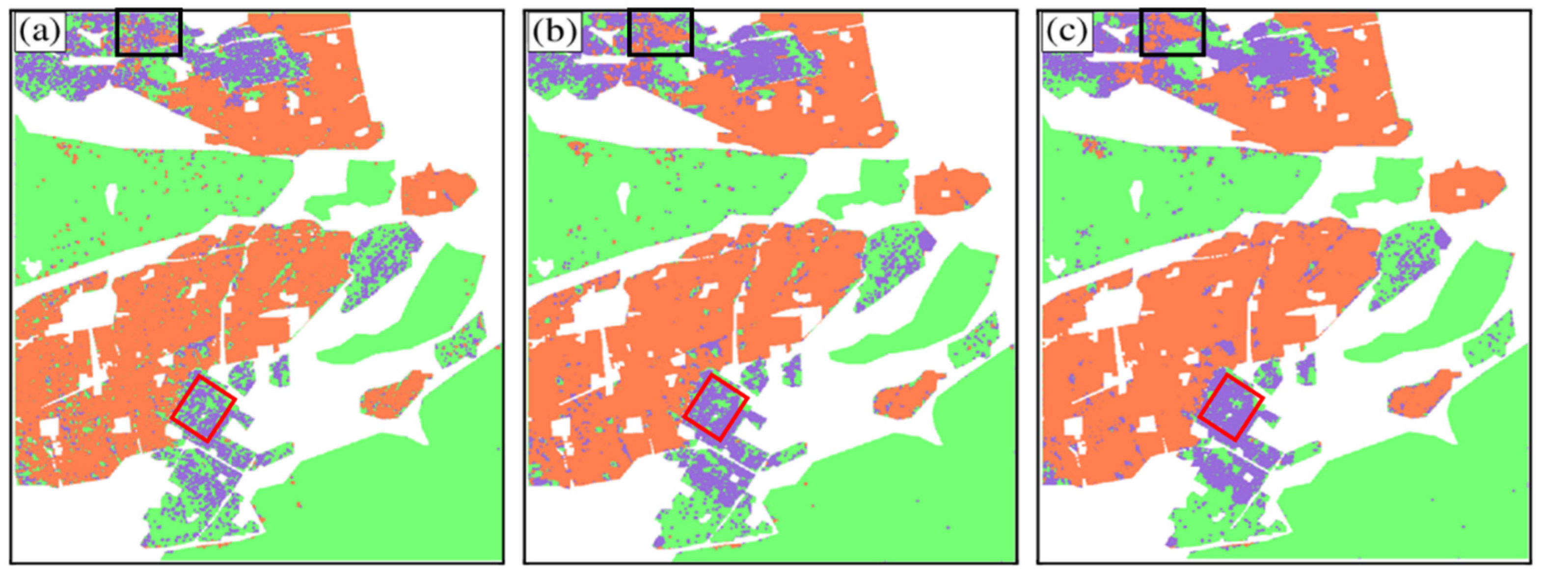
Although the difference in scattering powers from oriented buildings and forests is enhanced by the above two kinds of strategies, the misclassification of oriented buildings and forests is still a common phenomenon, which makes it difficult to extract the building areas from the PolSAR image [
39]. In fact, it is hard to separate highly oriented buildings from the PolSAR signal because the corresponding scattering contributions are mainly recorded by the HV channel, presenting a scattering process similar to that of forests. To solve this problem, two polarimetric parameters, polarization orientation angle (POA) variance and helix angle (HA) variance, recording the texture information, are proposed to enhance the distinction between buildings and forests, which is complementary to the scattering power in classification.
3. Study Areas and Datasets
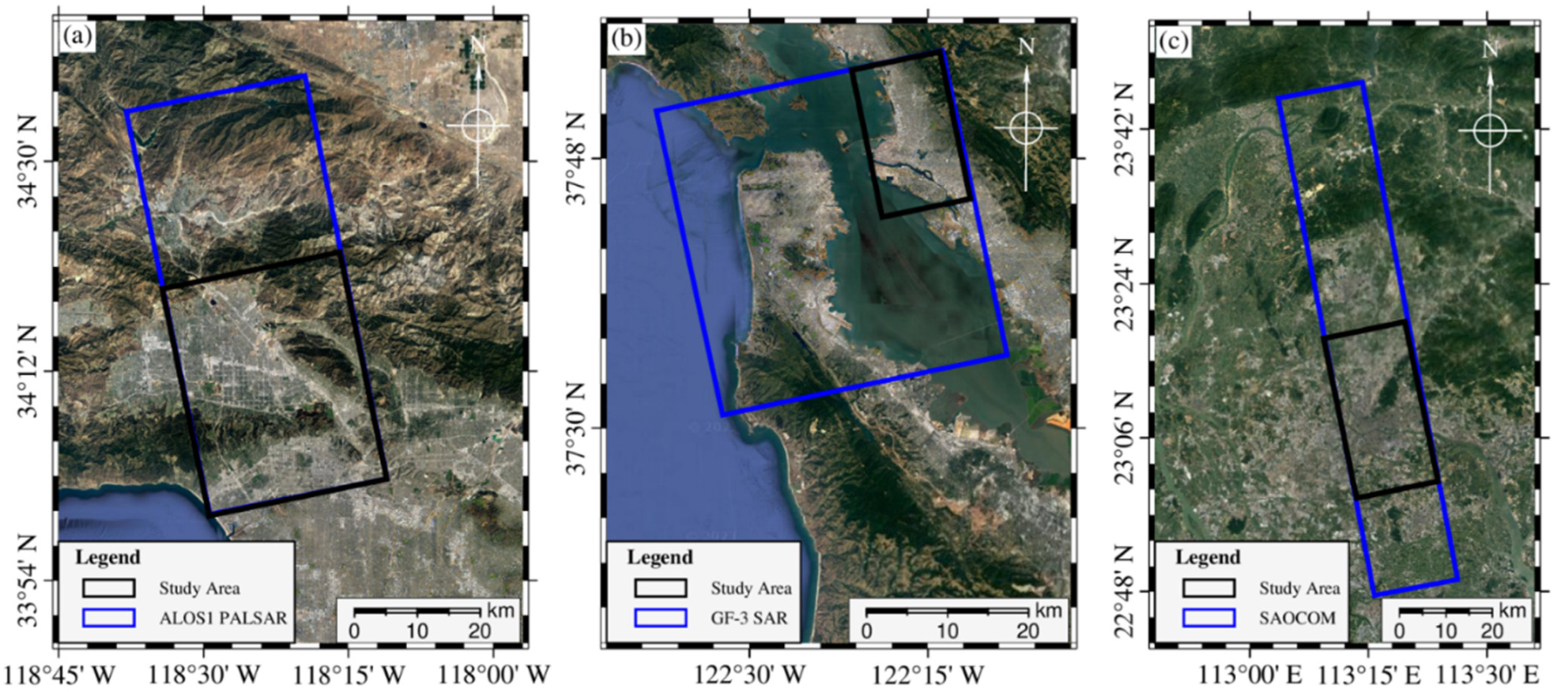
To test the proposed method, we used three different PolSAR datasets. The first one was from the ALOS1 PALSAR at L-band, acquired over San Fernando Valley, California, USA. This image was collected on 8 June 2006 in the PLR mode. The second dataset, from the GaoFen-3 at C-band, was collected over Oakland, Virginia, USA. This image was acquired on 15 September 2017. The third dataset, from SAOCOM data at the L-band, was collected over Guangzhou, China. This image was acquired on 12 November 2022. All of these SAR images were acquired in Stripmap mode with full polarization. The coverage of these datasets is shown in
Figure 3, and the corresponding parameters of all the PolSAR data used in this study are listed in
Table 1.
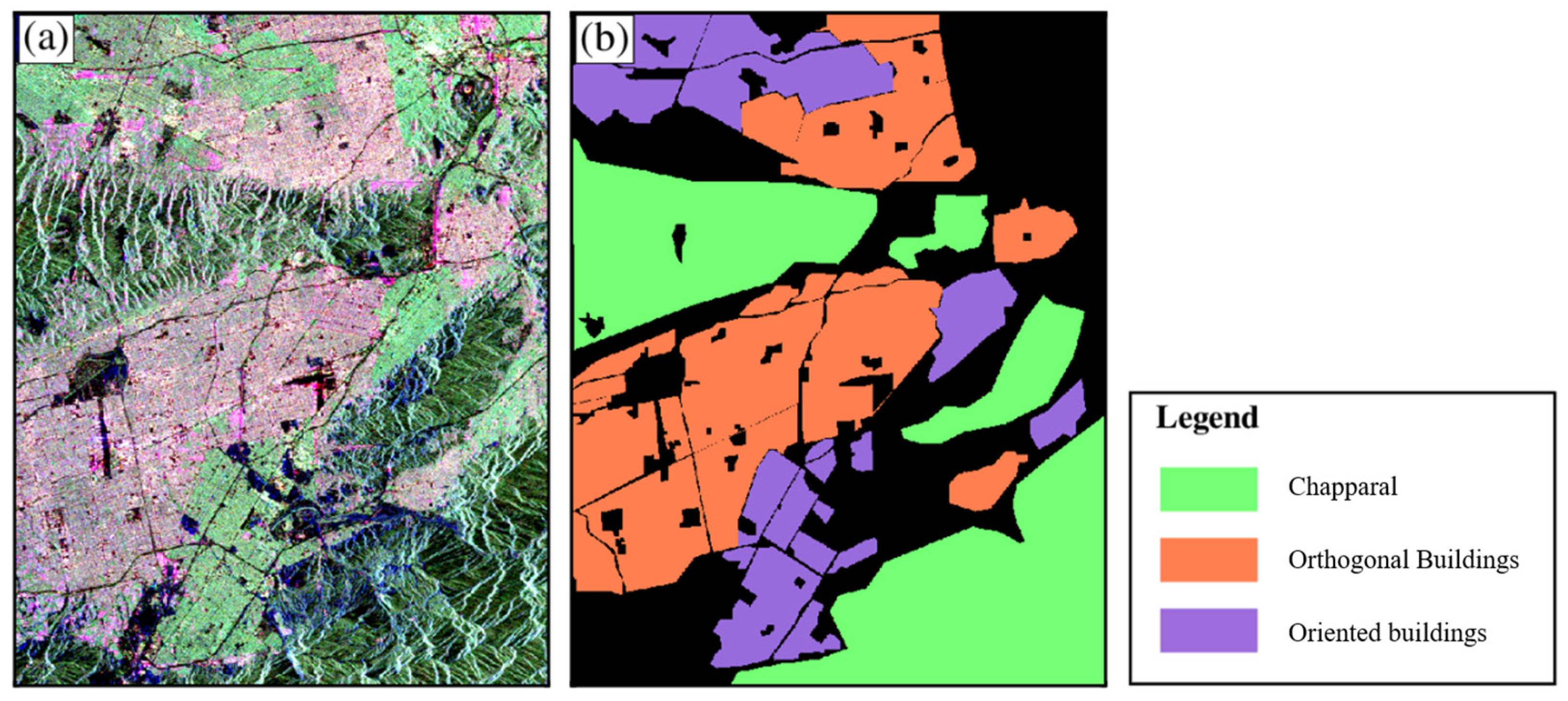
To assess the classification results derived by the proposed method, ground truth data of land cover type were employed, manually outlined against the optical map. In the San Fernando Valley test site, the predominant land cover types include forests, orthogonal buildings, and oriented buildings. These land types are well-suited for evaluating the effectiveness of the proposed method. The Oakland test site encompasses the same land cover types found in the San Fernando Valley test site, which provides a similar environment for evaluating the proposed method. Compared with the first two test areas, the third research area, located in Guangdong Province, China, covers more fragmented ground categories. Experiments using three PolSAR images covering targets with different characteristics can more strongly demonstrate the role of the proposed parameters in land-cover classification.
6. Conclusions
Classifying forests and buildings with different orientations is important for urban planning and forest parameter inversion. However, existing decomposition methods cannot effectively distinguish buildings with different orientation angles from forests. The core reason for this is the overestimation of volume scattering. Although novel decomposition schemes have been proposed to reduce the volume scattering power for oriented buildings, the volume scattering power for forest areas is also reduced. This does not effectively improve classification accuracy. In such a case, a type of polarimetric parameter that is capable of distinguishing oriented buildings from forests makes sense for land cover classification. Therefore, polarization orientation angle (POA) variance and helix angle (HA) variance are proposed. The two proposed parameters record the texture information of ground targets, and they supplement the scattering power in classification. Between adjacent pixels, the POAs of vegetation canopy scatterers are relatively random, the POAs of orthogonal buildings are more regular, and the POAs of oriented buildings are slightly higher than those of orthogonal buildings due to the continuous reflection of SAR signals between walls. Thus, the variances in orientation angles are the largest for forested areas, followed by oriented buildings and forests. The introduction of POA and HA variances can contribute to the efficacy of the decomposition method in classifying oriented buildings and forests. The full polarization data obtained by different satellites working at different bands are used to demonstrate the proposed parameters. The classification accuracy increased by 23.78%, attributed to the proposed polarimetric parameters. Furthermore, the proposed parameters have deepened the understanding of POA and HA of different ground targets.


