Abstract
Forests are essential for sustaining ecosystems, regulating the climate, and providing economic benefits to human society. However, activities such as commercial practices, fuelwood collection, and land use changes have resulted in severe forest degradation and deforestation. Timor-Leste, a small island nation, faces environmental sustainability challenges due to land use changes, limited infrastructure, and agricultural practices. This study proposes a simplified and highly accessible approach to assess deforestation (SHAD) nationally using limited human and non-human resources such as experts, software, and hardware facilities. To assess deforestation in developing countries, we utilize open-source software (Dryad), employ the U-Net deep learning algorithm, and utilize open-source data generated from the Google Earth Engine platform to construct a time-series land cover classification model for Timor-Leste. In addition, we utilize the open-source land cover map as label data and satellite imagery as model training inputs, and our model demonstrates satisfactory performance in classifying time-series land cover. Next, we classify the land cover in Timor-Leste for 2016 and 2021, and verified that the forest classification achieved high accuracy ranging from 0.79 to 0.89. Thereafter, we produced a deforestation map by comparing the two land cover maps. The estimated deforestation rate was 1.9% annually with a primary concentration in the northwestern municipalities of Timor-Leste with dense population and human activities. This study demonstrates the potential of the SHAD approach to assess deforestation nationwide, particularly in countries with limited scientific experts and infrastructure. We anticipate that our study will support the development of management strategies for ecosystem sustainability, climate adaptation, and the conservation of economic benefits in various fields.
1. Introduction
Forests play a crucial role in sustaining wildlife habitat, regulating the climate, conserving biodiversity, and providing economic benefits to human society [1,2,3]. In particular, tropical forests are widely recognized as biodiversity hotspots [4,5] and offer significant social benefits to local communities and the global society [6,7]. However, human activities, such as commercial practices, fuelwood collection, and land use changes, have resulted in severe forest degradation and deforestation (FDD), leading to a reduction in the functionality and diversity of terrestrial ecosystems [8,9,10,11,12,13].
Assessing FDD is essential for developing effective forest conservation strategies. Additionally, monitoring and understanding the extent of FDD is critical to assess the impact of human activities on forest ecosystems and identify areas where conservation efforts are needed [14,15]. The assessment of FDD can aid the evaluation of the effectiveness of conservation interventions, such as protected areas, reforestation programs, and sustainable forest management practices [16,17]. Furthermore, quantifying the socio-economic impacts of FDD and identifying strategies to mitigate them is crucial for achieving sustainable forest management and protecting the global environment [18,19,20].
Timor-Leste, a small island nation located in Southeast Asia, gained independence from Indonesia in 2002 and has since made significant progress in development and stability. However, despite the country’s considerable advancements, it faces challenges regarding environmental sustainability, particularly in relation to its predominantly agriculture-based economy, which includes coffee, rice, and corn production. The lack of infrastructure and sustainable agricultural practices in Timor-Leste has led to land use changes and the use of firewood as an alternative source of energy [21,22,23]. Consequently, these factors have contributed to an estimated deforestation rate of approximately 1.4% annually in Timor-Leste [24].
Although there are some challenges associated with the national-level assessment of FDD, various methods can be employed to quantify its extent [25,26]. Deep learning techniques based on remote sensing data, such as land cover classification modeling, have gained significant attention [27,28,29,30]. Among various deep learning techniques, convolutional neural networks, recurrent neural networks, and generative adversarial networks are widely used. Additionally, U-Net algorithms, particularly a fully convolutional neural network comprising an encoder and decoder, have attracted attention for image segmentation and land cover classification using remote sensing data [31,32,33,34]. Giang et al. [35] successfully classified land cover types from multispectral images using U-Net algorithms, and achieved high overall accuracies. John and Zhang [36] employed modified versions of U-Net algorithms to classify forest cover changes and detect forest degradation in specific areas using time-series imagery.
Despite the development of various algorithms and techniques for assessing FDD, many developing countries with limited resources for scientific research face significant challenges in monitoring and managing FDD [37,38]. However, these countries have made some progress in recent years in developing their capacity for environmental monitoring and management [39,40]. For example, many countries have established national systems for monitoring land use, forest cover change, and human activities using field survey data and satellite imagery [41,42,43,44]. However, despite this progress, there are still significant challenges associated with providing effective conservation strategies based on high-quality FDD assessment. For example, limited human resources capable of accurately labeling land cover classes and FDD areas for use in deep learning algorithms, combined with the limited scientific capabilities of applying advanced techniques and approaches, make it difficult to develop effective conservation strategies.
In the developing world, data often tend to be incomplete, noisy, or biased [45,46]. Data collection initiatives are typically led by citizens, journalists, and non-profit organizations with good intentions, but limited technical expertise, for the construction of high-quality datasets. Moreover, the utilization of deep learning algorithms for FDD assessment require the application of advanced techniques with clean datasets, which demands substantial education, particularly in computer and environmental science [47]. The challenges faced in the developing world make the rapid assessment of FDD difficult and hinder a timely response to the climate crisis and natural hazards. To overcome these challenges, simplified deep learning algorithms embedded in open-source software and open-source datasets can be utilized. However, while open-source datasets and simplified algorithms are generally suitable for global-scale assessments, their applicability at the national or local scales may be uncertain.
Therefore, this study aimed to propose a simplified and high accessibility deforestation (or forest degradation) (SHAD) assessment approach for countries with limited scientific resources and facilities, while minimizing the cost of constructing a deforestation detecting model, using the U-Net algorithm. To achieve this, open-source software suitable for the U-Net algorithm was utilized and open-source data were employed to simplify the labeling process, which is the most expensive aspect of U-Net-based image segmentation modeling. Ultimately, through the evaluation of land cover and forest degradation using the model developed in this study, we aim to overcome the limitations of scientific and human resources and propose an approach that enables highly accurate and fast assessment of deforestation. We anticipate our study will support the rapid detection of deforestation areas and enhance sustainability in countries with limited scientific resources.
2. Materials and Methods
2.1. Study Area
Timor-Leste, located at 8°33′24.68″S, 125°33′37.12″E (Dili; capital city of Timor-Leste), falls within a tropical monsoon climate zone, characterized by distinct wet and dry seasons (Figure 1). The northwest monsoon winds from December to March bring the primary wet season to most parts of the country, while the southeast trade winds prevail from May to October, except for the south coast and southern slopes, where the wet season persists until July. The variations in topographic conditions and precipitation patterns significantly affect temperature distinctions and the livelihoods of people, including the availability of drinking water, agricultural practices, and land use, and the land cover change that follows these patterns. These patterns pose natural barriers to development efforts owing to frequent natural disasters, such as landslides, erosion, flooding during the wet season, and drought during the dry season. Furthermore, there is an urgent need for forest conservation in Timor-Leste given the widespread deforestation in this country. According to FAO [48], the forest area in Timor-Leste was 966,000 ha in 1990 but reduced to 686,000 ha in 2015. The estimated annual forest change in Timor-Leste is −1.4 to −1.7%, and less effort is devoted to forest plantation in Timor-Leste [24,49].

Figure 1.
Location of Timor-Leste.
2.2. Datasets
In this study, we prepared the datasets for the development of the land cover classification model and for the land cover classification. In this study, we used a 4-band dataset in 2020 and ESA WorldCover 10m v100, which represents the near-real-time global land cover in 2020 based on Sentinel images, for model training. In addition, 4-band datasets in 2016 and 2021 were used for land cover classification (Table 1). The 4-band dataset consists of red, green, blue, and near-infra red (NIR) bands, based on natural (forest, other vegetation, open water, etc.) and anthropogenic (Built-up, Cropland, etc.) reflectance characteristics from imagery produced from the Sentinel-2 surface reflectance images [50,51,52,53]. All the datasets were collected from the GEE platform, and the datasets represent the median value during January to December, with filtering of 10% cloud cover to preserve the data quality. The datasets have a 10 m resolution and covered the entire Timor-Leste area.

Table 1.
Components of the input datasets applied for land cover classification and model training.
2.3. SHAD Approach
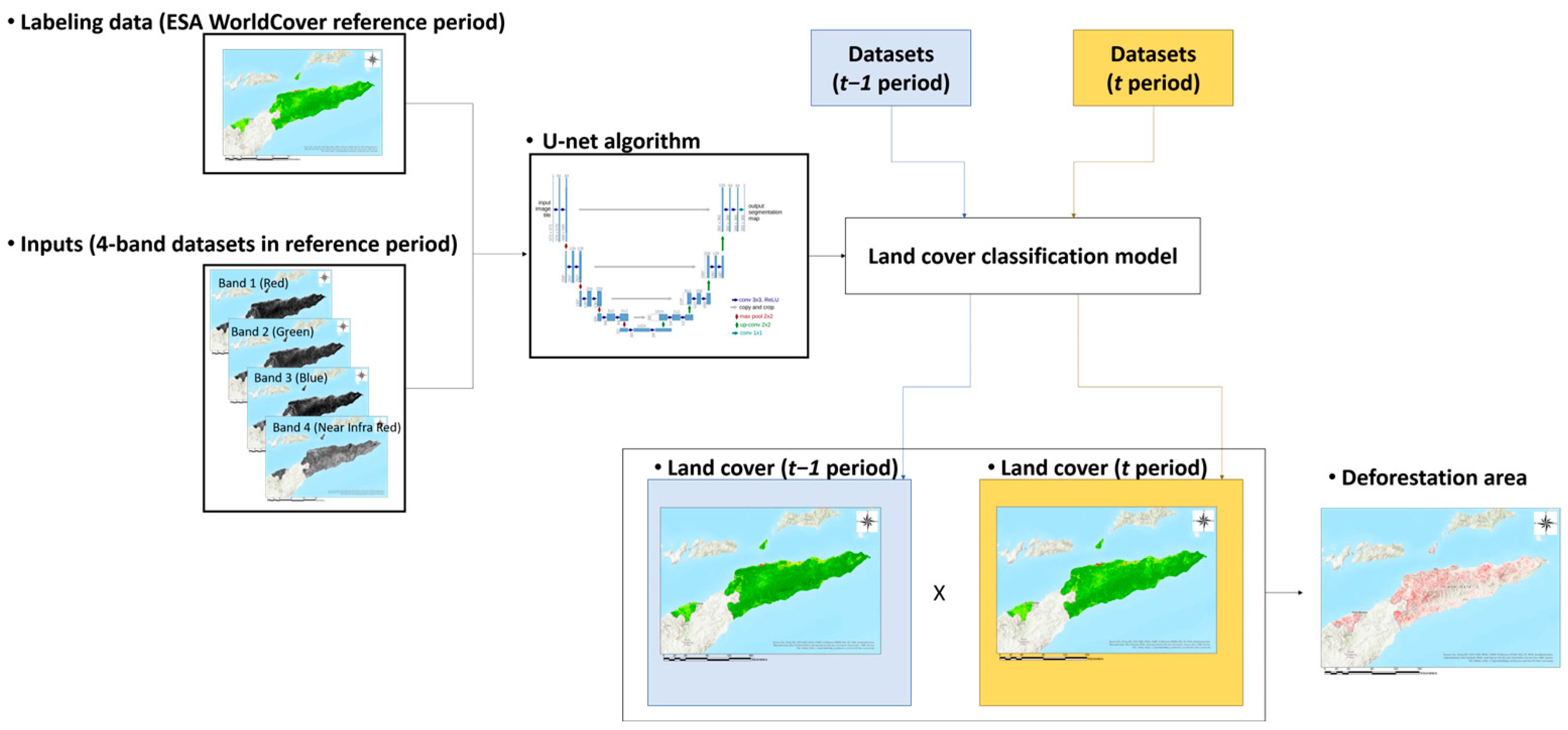
Nationwide FDD assessment, while securing outstanding accuracy, requires sufficient resources to classify the land cover change [37,38,41,42,43,44]. However, the survey data, scientific experts, and the budget of research of many countries are limited. In this study, we propose a SHAD approach, which can perform the rapid assessment of nationwide FDD using open-source software and spatial data (Figure 2). To implement this approach, first, a land cover classification model based on a deep learning algorithm was developed, and the land cover map in the user-defined period was generated. This approach only requires labels and inputs that can be obtained from open-source data, such as the European Space Agency (ESA) WorldCover 10m v100 and downloaded from Google Earth Engine (GEE) platform. The FDD assessment was performed using the developed model and the land cover map was classified. Thereafter, the nationwide FDD was estimated by comparing the land cover maps generated in the user-defined time periods.
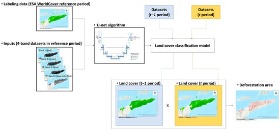
Figure 2.
Conceptual images for assessing the FDD based on simplified and high accessibility approach for deforestation (SHAD) assessment.
The accuracy of the open-source label data used in the SHAD approach was approximately 75%, which is reasonable but not satisfactory to use as ground truth data. Therefore, we verified the SHAD approach in the three steps: evaluation of the classified model using training and validation accuracy, assessment of land cover classification results for each time period using user’s, producer’s, and overall accuracy for each class, and assessment of the estimation of deforestation using precision, recall, and the kappa coefficient.
2.3.1. Dryad U-Net Process: Land Cover Classification and Deforestation Assessment
The Dryad platform (Deep-learning and Remote Sensing analysis for Agroforestry and Drought; https://www.platform-dryad.com/, accessed on 23 August 2022) was developed for the analysis of remote sensing data by both experts and non-experts. This platform provides powerful tools for analyzing Earth observation data in a raster format, and incorporates the U-Net algorithm for semantic segmentation. The embedded algorithm is useful for classifying land cover and developing time-series land cover maps [27,28,29,30,31,36].
As it is based on fully convolutional network architectures, the U-Net algorithm is widely applied for semantic segmentation, particularly in medical and environmental sciences [31]. Similar to autoencoders, this algorithm is divided into two sequential stages, consisting of an encoder, which can successively down-sample the feature maps generated through convolutional filters, and a decoder, which can up-sample the down-sampled map back to the original input shape for inference. This process is similar to the letter U, with a contracting path on the left and expansive path on the right. This process can be further enhanced using connections bridging the down-sampling and up-sampling steps to propagate information.
Many studies have employed the U-Net algorithm to classify land cover and monitor FDD. John and Zhang [36] applied the attention U-Net algorithm, which can replicate the human ability, to specific stimuli. It used three types of datasets to detect deforestation within satellite imageries and to compare the performance of each dataset. De Bem et al. [54] used three types of deep learning architectures, including U-Net algorithm, to detect deforestation in the Brazilian amazon based on Landsat data.
2.3.2. Assessment
The SHAD approach only utilizes the open-source software and data whose quality is uncertain. In this study, to verify the accuracy the model, we conducted a three-step assessment process, consisting of the assessment of the model development, land cover classification, and FDD evaluation. First, we verified the performance of the developed model by evaluating the training and validation accuracy in the Dryad platform. The training and validation accuracy are the performance metrics used to evaluate the effectiveness of the model during the model development. These accuracies indicate how well the model can predict (estimate) the correct labels for the training examples. The training accuracy was calculated by comparing the estimated labels with the actual labels of the training dataset. The validation dataset is distinct from the training dataset and was used to evaluate the performance of the model on unseen data, and indicates the accurate estimations on new examples.
Second, we verified the land cover classification by evaluating the user’s, producer’s, and overall accuracy (Equations (1)–(3)) [55]. For this verification, we compared the estimated land cover map with the high-resolution reference images collected from Google Earth Pro. Google Earth Pro utilizes various high-resolution satellite imagery sources to provide detailed and up-to-date imagery. In particular, the WorldView series can provide various high-resolution imagery, ranging from 30 to 50 cm per pixel.
The user’s and producer’s accuracies illustrate the classification quality of each single class i. The classification accuracy from the user perspective can be defined as the ratio of classified pixels that correctly match the reference images. The accuracy of classification from the producer perspective can be defined as the ratio of the pixels of the reference images that correctly match those of the classified map. In the equations, n represents the total number of considered pixels, and nii represents the pixels matching the classified map and reference images in the specific land cover class. Additionally, ni+ and n+i represent the marginal sum of the columns and rows, respectively, and q is the number of classes in Equations (2) and (3).
Third, we assessed the deforestation based on the precision, recall, overall accuracy, F-score, and kappa coefficient (Equations (3)–(7)) [56,57]. The deforestation areas were estimated by comparing forest change generated from the land cover map in the simulation periods, and the deforestation reference images were collected from Google Earth Pro.
where TP is the true positive and represents the deforestation area in the classification and reference data; FP is the false positive and represents incorrectly classified deforestation; TN is the true negative and represents the non-deforestation area in the classification and reference data; and FN is the false negative and represents the incorrect classification of non-deforestation.
F-score is measured based on the precision and recall of the classification results. It is the harmonic mean of the precision and recall, and can symmetrically describe both precision and recall in one metric.
where is the rate of agreement between the reference data and classification, and is the expected rate of agreement due to chance.
2.3.3. Assessment of FDD: Model Development and Land Cover Classification
We constructed the land cover classification model using the Dryad platform. The ESA WorldCover 10m v100 dataset represents the land cover status in Timor-Leste in 2020 and was utilized as the label data to train the land cover classification model. The ESA WorldCover land cover map in Timor-Leste consists of eight land cover classes (Forest (with Mangroves), Shrubland, Grassland, Cropland, Built-up, Barren, and Open water). In addition, we used the 4-band dataset in 2020 (Table 1). For the model training, we used a patch size of 256 to generate training and validation images. Additionally, 60% of the generated images were used for training and 40% for model validation, and 343,625 parameters were adapted in this study.
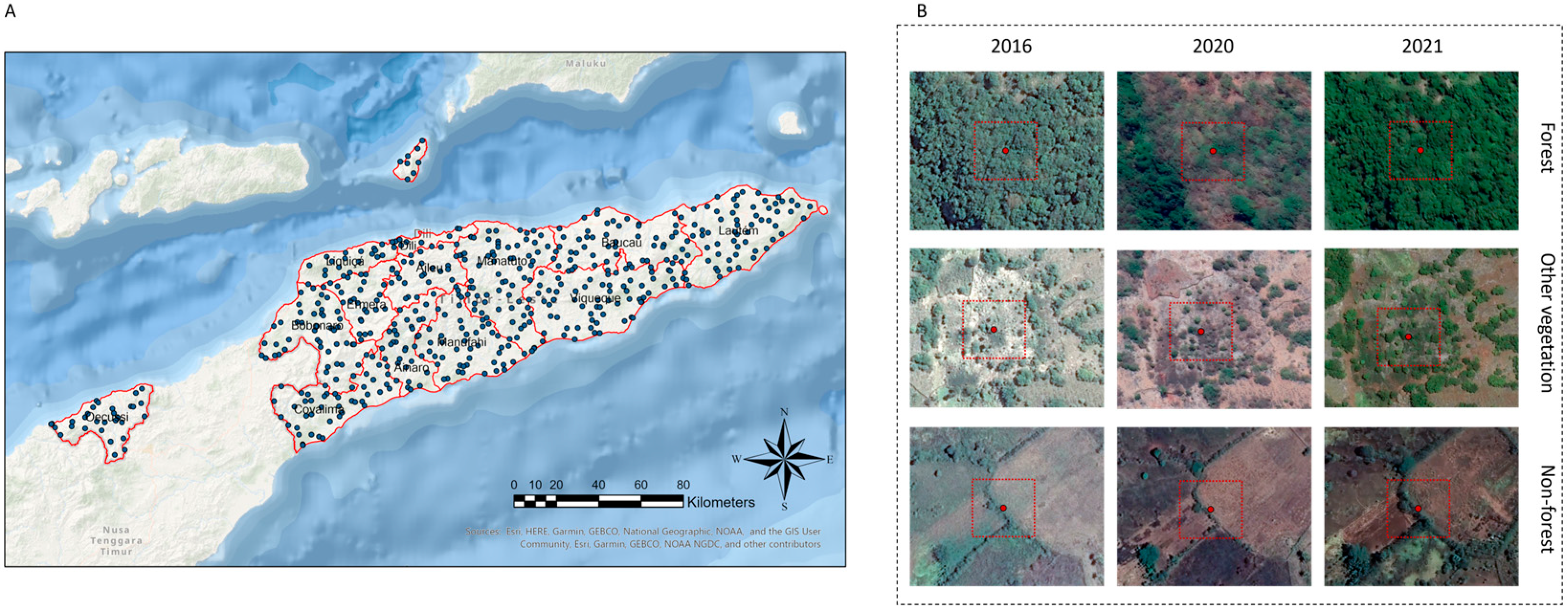
We utilized the land cover classification model developed by the U-Net based Dryad platform to classify land cover in 2016 and 2021 using the 4-band datasets from the matching periods (Table 1). To verify the classification results, we dispersed 500 random points in the study area and generated land cover reference images (Figure 3). To compare the land cover classified map and reference images, we used a five-class reclassified land cover map (Table 2).
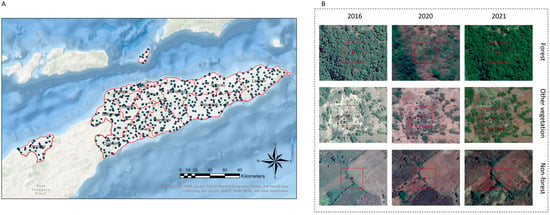
Figure 3.
Land cover accuracy test sampling points and test images. (A) A total of 500 random points dispersed in Timor-Leste; (B) an example of the reference images obtained from Google Earth Pro for each period.

Table 2.
Reclassification of the land cover for accuracy assessment.
2.3.4. Assessment of FDD: Estimation of the Deforestation Areas
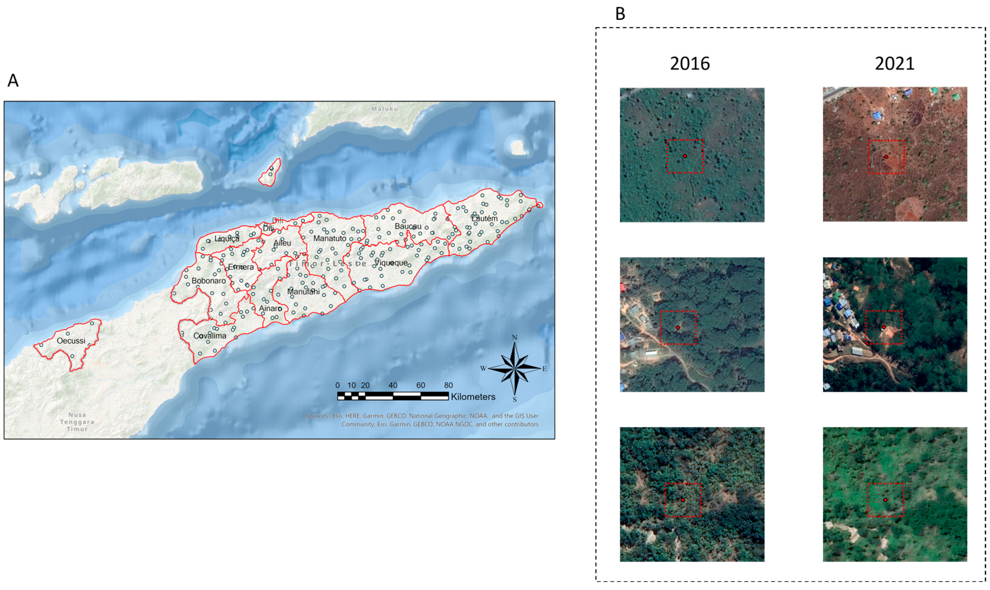
The SHAD approach estimates deforestation by detecting the forest change in the land cover maps of 2016 and 2021. Deforestation areas were defined as the transition areas from forest areas to other land cover types in the target periods. To assess our estimation, we dispersed 250 random points on the forest area in the 2016 land cover classification map (Figure 4). Additionally, we utilized Google Earth Pro’s time-series map as the reference images, and evaluated the forest transition by comparing land cover changes. Thus, we used imagery from after January 2016 in Google Earth Pro as the reference images for the past period of land cover, and imagery before December 2021 in Google Earth Pro as the reference images for the future period.
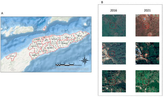
Figure 4.
Example of the deforestation accuracy test sampling points and reference images. (A) A total of 250 random points dispersed in Timor-Leste; (B) an example of deforestation reference images in 2016 to 2021 provided from Google Earth Pro.
3. Results
3.1. SHAD Approach Assessment
3.1.1. Evaluation of Model Performance and Land Cover Classification
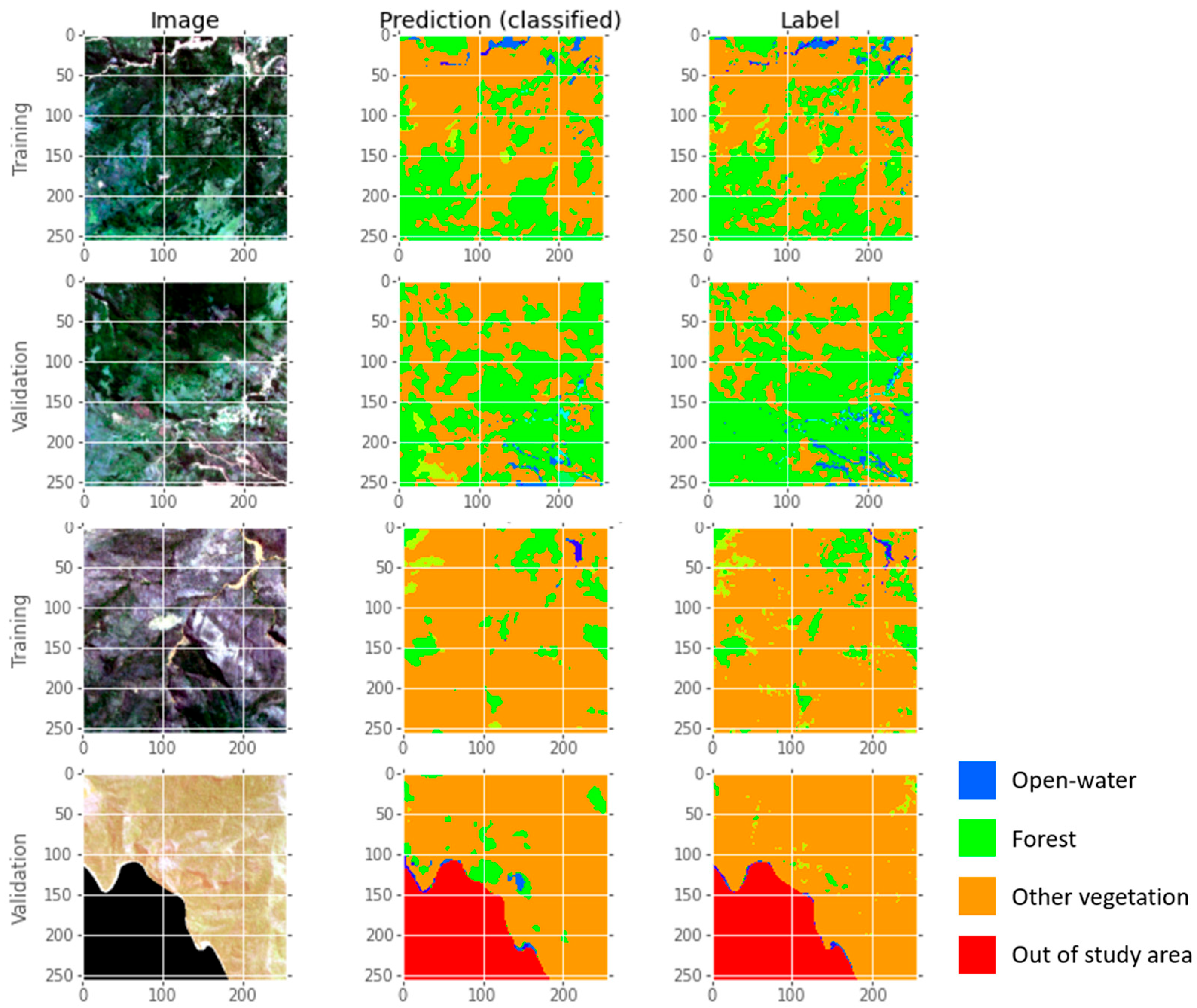
In this study, to develop the land cover classification model for Timor-Leste, we utilized the ESA WorldCover 10m v100 as the label data and the 4-band dataset divided into a patch size of 256 to generate the training and validation data. We used 60% of data for training and 40% for validation (Figure 5). To verify the performance of the model, we evaluated the training and validation accuracy. The accuracy of the model for the training and validation datasets was 0.92 and 0.82, respectively, indicating the sufficient performance of the mode and its potential for classifying the land cover in 2016 and 2021.
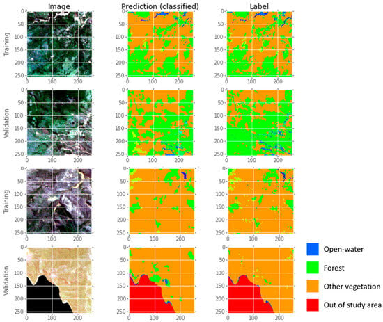
Figure 5.
Example of the model training results in the U-Net based Dryad platform. The training and validation accuracy are 0.92 and 0.82, respectively.
The overall accuracy for the evaluation of the land cover classification by comparing the classified land cover map and reference images ranged from 0.68 to 0.79 (Table 3). The highest overall accuracy (0.79) was obtained for the evaluation result for 2020, and it was used as the comparative criteria for verifying the other land cover classification using the model based on the SHAD approach. The overall accuracy for 2016 and 2021 was 0.68 and 0.74, respectively. During the specific land cover class level evaluation, the highest producer’s accuracy (0.80 to 0.91) and user’s accuracy (0.79 to 0.89) values were observed for the forest area. The accuracy of the verifying land cover maps in 2016 and 2021 was similar to that for in 2020. These results indicate the sufficient performance of the land cover map classified using the SHAD approach to estimate the forest areas in other time periods. However, there was uncertainty in defining the land cover in the evaluation of other classes. Non-forest land cover class (Cropland, Built-up, Barren) exhibited the highest variation between the accuracy values with a producer’s accuracy of 0.21 to 0.42 and user’s accuracy of 0.45 to 0.71. Although the SHAD approach exhibited large uncertainty for land cover classification in specific land cover types, it still exhibited a large potential for the estimation of the deforestation areas.

Table 3.
Evaluation of producer’s, user’s, and overall accuracy for each land cover class.
3.1.2. FDD Assessment
To detect deforestation areas using the SHAD approach, we used 250 random points to assess the forest change. This approach estimated 51 locations as forest change (deforestation) areas and 199 locations as sustained forest areas (Table 4). However, 36 locations were assessed as deforestation areas, and 214 were assessed as sustained forest in the reference data.

Table 4.
Confusion matrix of the deforestation detection model. Values represent the number of locations for detecting deforestation or sustained forest.
This indicates that there were 32 true positive and 20 false positive values in the deforestation detection results, implying the overestimation of the deforestation detection results. In contrast, there were just 5 false negative and 194 true negative values for the detection of sustained forest, indicating the higher performance of the model for detecting sustained forest than deforestation areas.
Although the FDD assessment from the SHAD approach has a problem in overestimation, it has high potential to rapidly assess FDD and for use in implementation of management strategies for environmental conservation. The precision, recall, overall accuracy, F-score, and kappa coefficient of the quantifying evaluation result of deforestation (or sustained forest) detection were 0.61, 0.86, 0.90, 0.71, and 0.65, respectively.
3.2. Land Cover Classification and Forest Change in Timor-Leste
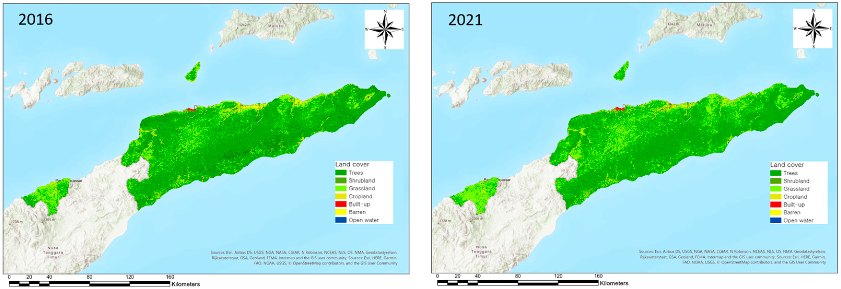
Figure 6 shows the land cover classification by the U-Net-based model developed in this study. The land cover in 2016 was dominated by forest (68.8%) and other vegetation (26.8%) (Table 5), and the land cover in 2021 was also dominated by forest (59.2%) and other vegetation (37.4%). However, the forest areas decreased by 9.6% in the 5-year period, indicating that Timor-Leste experienced an annual forest loss of 1.92%. In contrast, the other vegetation increased by 10.6% (2.1% annual increase) in the same period.
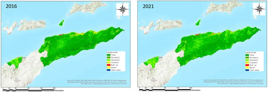
Figure 6.
Land cover classification results of the model developed in this study. The left land cover map represents the 2016 classification results, and the right land cover map represents the 2021 classification results.

Table 5.
Composition of the land cover class in 2016 and 2021. (Unit: %).
3.3. Deforestation Detection in Timor-Leste
After the classification of the land cover in 2016 and 2021, the deforestation areas detected in 2016 and 2021 were compared to determine the forest change (Figure 7A). Deforestation was detected by comparing the changed forest area in 2016 to other types of land cover in 2021. Deforestation in Timor-Leste is distributed nationwide [23]. In particular, the deforestation ratio in the high-population municipalities is high. The results of this study confirmed the nationwide distribution of the deforestation areas, and the extensive deforestation in the northwestern side of the mainland in Timor-Leste (Dili, Liquiçá, Baucau, Bobonaro, Ermera, Aileu) (Figure 7B).

Figure 7.
(A) Estimated deforestation areas in 2016 and 2021 using the SHAD method; (B) the level of deforestation by municipalities in Timor-Leste.
Dili is a municipality which is the location of the capital city (Dili), and deforested areas are confirmed by 10.5% in the entire Dili area during the period of 2016 to 2021 (Table 6). Deforested areas are confirmed by 14.4% and 13.9% in Liquiçá and Baucau, respectively, in the same period. Furthermore, deforested areas are confirmed by 14.4% and 20.6% in the areas of Bobonaro and Aileu, respectively, during 2016 to 2021. Ermera has the highest deforestation areas in the same period, of 23.4%.

Table 6.
The status of extent and deforestation areas by municipalities in Timor-Leste (Unit: ha; %).
4. Discussion
In Timor-Leste, environmental sustainability is a significant concern owing to FDD [24]. Despite the country’s progress in terms of development and stability, there are challenges associated with its agriculture-based economy, which includes coffee and rice production [21,22,23]. For example, the limited infrastructure and agricultural practices have led to land use changes and increased reliance on firewood as an energy source [22,23]. Consequently, these factors have contributed to an estimated deforestation rate of approximately 1.4 to 1.7% per year [24]. Many countries facing FDD issues have implemented various strategies for environmental sustainability. The accurate quantification of FDD is crucial for developing effective conservation strategies; however, countries with FDD problems often lack the necessary human and non-human resources for nationwide FDD assessments.
In this study, we propose the SHAD approach to support FDD evaluation in countries with limited resources. We tested this approach in Timor-Leste by generating land cover maps for 2016 and 2021 to assess the FDD. To ensure accuracy, we utilized a three-step (model performance, land cover classification, and FDD verification) accuracy assessment process. Our model demonstrated satisfactory performance (0.92 for training accuracy and 0.82 for validation accuracy) for classifying land cover time-series maps and estimating FDD (Figure 6 and Figure 7). In addition, the forest classification exhibited the highest producer’s and user’s accuracy, similar to the accuracy of the open-source label data (Table 3). These results highlight the potential of the SHAD approach for estimating forest change over time and for the rapid assessment of FDD.
The forest area in Timor-Leste has steadily decreased from 2016 to 2021, with a reduction in the forest cover from 68.8 to 59.2% (Table 5). The deforestation rate based on the change in forest cover during this period is estimated to be 1.9% annually. This result is overestimated compared to previous reports from FAO and UDNP [24,48,49]. However, these reports are based on literature reviews and historical trend analysis, which have limitations in fully capturing the current status of FDD. The Global Forest Resource Assessment also indicates a net annual change of −1.4% annually in the forest area every 10 years from 1990 to 2020 due to a lack of surveying data and national reporting [24]. The accurate quantification of the deforestation rate remains a challenge.
At a global level, reducing FDD is crucial for climate change adaptation and socio-environmental conservation [5,11,24]. Under the Paris Agreement, countries have committed to nationally determined contributions (NDCs) to reduce carbon emissions and enhance social and environmental sustainability [58]. Achieving these NDCs often involves cooperation between countries facing FDD issues and the production of internationally transferred mitigation outcomes (ITMOs). However, countries facing FDD problems, primarily developing countries, often lack information about their forest status and field survey data [24]. The SHAD approach offers a simplified and accessibility method for the rapid assessment of deforestation, providing a general estimate for countries with limited resources. Additionally, it can guide the development of land cover classification models and FDD evaluations in target countries and support the establishment of management strategies for their environmental sustainability.
5. Conclusions
This study proposes the rapid assessment of deforestation using the SHAD approach, which utilizes open-source software and data. Our approach was used to successfully develop a time-series land cover classification model and assess FDD in Timor-Leste. The results exhibited promising performance, with prominent accuracy in classifying forest areas. The estimated deforestation rate in Timor-Leste was 1.9% annually, with a primary concentration in the northwestern municipalities with high population density and human activities. The results of this study demonstrated the potential of the SHAD approach as a simplified and accessible method for evaluating FDD, particularly in countries with limited resources. This approach offers the rapid assessment of FDD using deep learning techniques and can inform the development of management strategies for ecosystem sustainability, climate adaptation, and the conservation of economic benefits in local (or nationwide) communities.
Author Contributions
Conceptualization, W.C. and C.-H.L.; methodology, W.C. and C.-H.L.; validation, W.C. and C.-H.L.; formal analysis, W.C.; investigation, W.C. and C.-H.L.; data curation, W.C. and C.-H.L.; writing—original draft preparation, W.C.; writing—review and editing, C.-H.L.; visualization, W.C.; supervision, C.-H.L. All authors have read and agreed to the published version of the manuscript.
Funding
This research was funded by the National Research Foundation of Korea grant provided by the Ministry of Science and ICT (No. 2022R1C1C1008489) and the Kookmin University grant.
Data Availability Statement
Not applicable.
Acknowledgments
We appreciate the cooperation of SK Forest and the Timor-Leste government, who provided the regional information and field campaign opportunity. And especially thanks to Sue Kyoung Lee, who actively facilitate the Timor-Leste project.
Conflicts of Interest
The authors declare no conflict of interest.
References
- Mori, A.S.; Lertzman, K.P.; Gustafsson, L. Biodiversity and ecosystem services in forest ecosystems: A research agenda for applied forest ecology. J. Appl. Ecol. 2017, 54, 12–27. [Google Scholar] [CrossRef]
- Thompson, I.D.; Okabe, K.; Tylianakis, J.M.; Kumar, P.; Brockerhoff, E.G.; Schellhorn, N.A.; Parrotta, J.A.; Nasi, R. Forest biodiversity and the delivery of ecosystem goods and services: Translating science into policy. BioScience 2011, 61, 972–981. [Google Scholar] [CrossRef]
- Munasinghe, M.; Wells, M. Protection of natural habitats and sustainable development of local communities. Conserv. West Cent. Afr. Rainfor. 1992, 161–168. [Google Scholar]
- Myers, N. Threatened biotas: “hot spots” in tropical forests. Environmentalist 1998, 8, 187–208. [Google Scholar] [CrossRef]
- Ginsberg, J. Global conservation priorities. Conserv. Biol. 1999, 13, 5. [Google Scholar] [CrossRef]
- Sheil, D.; Wunder, S. The value of tropical forest to local communities: Complications, caveats, and cautions. Conserv. Ecol. 2002, 6, 9. [Google Scholar] [CrossRef]
- Balick, M.J.; Elisabetsky, E.; Laird, S.A. (Eds.) Medicinal Resources of the Tropical Forest: Biodiversity and Its Importance to Human Health; Columbia University Press: New York, NY, USA, 1996. [Google Scholar]
- Allen, J.C.; Barnes, D.F. The causes of deforestation in developing countries. Ann. Assoc. Am. Geogr. 1985, 75, 163–184. [Google Scholar] [CrossRef]
- Köhlin, G.; Parks, P.J. Spatial variability and disincentives to harvest: Deforestation and fuelwood collection in South Asia. Land Econ. 2001, 77, 206–218. [Google Scholar] [CrossRef]
- Walker, R. Theorizing land-cover and land-use change: The case of tropical deforestation. Int. Reg. Sci. Rev. 2004, 27, 247–270. [Google Scholar] [CrossRef]
- Faria, D.; Morante-Filho, J.C.; Baumgarten, J.; Bovendorp, R.S.; Cazetta, E.; Gaiotto, F.A.; Mariano-Neto, E.; Mielke, M.S.; Pessoa, M.S.; Rocha-Santos, L.; et al. The breakdown of ecosystem functionality driven by deforestation in a global biodiversity hotspot. Biol. Conserv. 2023, 283, 110126. [Google Scholar] [CrossRef]
- Veldkamp, E.; Schmidt, M.; Powers, J.S.; Corre, M.D. Deforestation and reforestation impacts on soils in the tropics. Nat. Rev. Earth Environ. 2020, 1, 590–605. [Google Scholar] [CrossRef]
- Sweeney, B.W.; Bott, T.L.; Jackson, J.K.; Kaplan, L.A.; Newbold, J.D.; Standley, L.J.; Hession, W.C.; Horwitz, R.J. Riparian deforestation, stream narrowing, and loss of stream ecosystem services. Proc. Natl. Acad. Sci. USA 2004, 101, 14132–14137. [Google Scholar] [CrossRef] [PubMed]
- UNFCCC. Outcome of the work of the ad hoc working group on long-term cooperative action under the convention. In United Nations Framework Convention on Climate Change; UNFCCC: Bonn, Germany, 2010. [Google Scholar]
- Benndorf, R.; Federici, S.; Forner, C.; Pena, N.; Rametsteiner, E.; Sanz, M.J.; Somogyi, Z. Including land use, land-use change, and forestry in future climate change, agreements: Thinking outside the box. Environ. Sci. Policy 2007, 10, 283–294. [Google Scholar] [CrossRef]
- Rudorff, B.F.T.; Adami, M.; Aguiar, D.A.; Moreira, M.A.; Mello, M.P.; Fabiani, L.; Amaral, D.F.; Pires, B.M. The soy moratorium in the Amazon biome monitored by remote sensing images. Remote Sens. 2011, 3, 185–202. [Google Scholar] [CrossRef]
- Kissinger, G.M.; Herold, M.; De Sy, V. Drivers of Deforestation and Forest Degradation: A Synthesis Report for REDD+ Policymakers; Lexeme Consulting: Vancouver, BC, Canada, 2012. [Google Scholar]
- Kumar, R.; Kumar, A.; Saikia, P. Deforestation and forests degradation impacts on the environment. In Environmental Degradation: Challenges and Strategies for Mitigation; Springer International Publishing: Cham, Switzerland, 2022; pp. 19–46. [Google Scholar]
- Foley, J.A.; Asner, G.P.; Costa, M.H.; Coe, M.T.; DeFries, R.; Gibbs, H.K.; Howard, E.A.; Olson, S.; Patz, J.; Ramankutty, N.; et al. Amazonia revealed: Forest degradation and loss of ecosystem goods and services in the Amazon Basin. Front. Ecol. Environ. 2007, 5, 25–32. [Google Scholar] [CrossRef]
- Ghazoul, J.; Burivalova, Z.; Garcia-Ulloa, J.; King, L.A. Conceptualizing forest degradation. Trends Ecol. Evol. 2015, 30, 622–632. [Google Scholar] [CrossRef]
- Vadrevu, K.; Ohara, T.; Justice, C. Land cover, land use changes and air pollution in Asia: A synthesis. Environ. Res. Lett. 2017, 12, 120201. [Google Scholar] [CrossRef]
- Bouma, G.A.; Kobryn, H.T. Change in vegetation cover in East Timor, 1989–1999. In Natural Resources Forum; Blackwell Publishing Ltd.: Oxford, UK, 2004; Volume 28, pp. 1–12. [Google Scholar]
- World Bank. Timor-Leste: Country Environmental Analysis; World Bank: Washington, DC, USA, 2009. [Google Scholar]
- FAO. Global Forest Resources Assessment 2020: Main Report; FAO: Rome, Italy, 2020. [Google Scholar] [CrossRef]
- Mertz, O.; Müller, D.; Sikor, T.; Hett, C.; Heinimann, A.; Castella, J.C.; Lestrelin, G.; Ryan, C.M.; Reay, D.S.; Schmidt-Vogt, D.; et al. The forgotten D: Challenges of addressing forest degradation in complex mosaic landscapes under REDD+. Geogr. Tidsskr.-Dan. J. Geogr. 2012, 112, 63–76. [Google Scholar] [CrossRef]
- Baker, D.J.; Richards, G.; Grainger, A.; Gonzalez, P.; Brown, S.; DeFries, R.; Held, A.; Kellndorfer, J.; Ndunda, P.; Ojima, D.; et al. Achieving forest carbon information with higher certainty: A five-part plan. Environ. Sci. Policy 2010, 13, 249–260. [Google Scholar] [CrossRef]
- Kuck, T.N.; Sano, E.E.; Bispo, P.D.C.; Shiguemori, E.H.; Silva Filho, P.F.F.; Matricardi, E.A.T. A Comparative Assessment of Machine-Learning Techniques for Forest Degradation Caused by Selective Logging in an Amazon Region Using Multitemporal X-Band SAR Images. Remote Sens. 2021, 13, 3341. [Google Scholar] [CrossRef]
- Maretto, R.V.; Fonseca, L.M.; Jacobs, N.; Körting, T.S.; Bendini, H.N.; Parente, L.L. Spatio-temporal deep learning approach to map deforestation in amazon rainforest. IEEE Geosci. Remote Sens. Lett. 2020, 18, 771–775. [Google Scholar] [CrossRef]
- Lee, S.H.; Han, K.J.; Lee, K.; Lee, K.J.; Oh, K.Y.; Lee, M.J. Classification of landscape affected by deforestation using high-resolution remote sensing data and deep-learning techniques. Remote Sens. 2020, 12, 3372. [Google Scholar] [CrossRef]
- Ortega, M.X.; Bermudez, J.D.; Happ, P.N.; Gomes, A.; Feitosa, R.Q. Evaluation of deep learning techniques for deforestation detection in the amazon forest. ISPRS Ann. Photogramm. Remote Sens. Spat. Inf. Sci. 2019, 4, 121–128. [Google Scholar] [CrossRef]
- Ronneberger, O.; Fischer, P.; Brox, T. U-net: Convolutional networks for biomedical image segmentation. In Medical Image Computing and Computer-Assisted Intervention–MICCAI 2015: 18th International Conference, Munich, Germany, October 5–9, 2015, Proceedings, Part III 18; Springer International Publishing: Cham, Switzerland, 2015; pp. 234–241. [Google Scholar]
- Solórzano, J.V.; Mas, J.F.; Gao, Y.; Gallardo-Cruz, J.A. Land use land cover classification with U-net: Advantages of combining sentinel-1 and sentinel-2 imagery. Remote Sens. 2021, 13, 3600. [Google Scholar] [CrossRef]
- Ulmas, P.; Liiv, I. Segmentation of satellite imagery using u-net models for land cover classification. arXiv 2020, arXiv:2003.02899. [Google Scholar]
- Zhang, W.; Tang, P.; Zhao, L. Fast and accurate land-cover classification on medium-resolution remote-sensing images using segmentation models. Int. J. Remote Sens. 2021, 42, 3277–3301. [Google Scholar] [CrossRef]
- Giang, T.L.; Dang, K.B.; Le, Q.T.; Nguyen, V.G.; Tong, S.S.; Pham, V.M. U-Net convolutional networks for mining land cover classification based on high-resolution UAV imagery. IEEE Access 2020, 8, 186257–186273. [Google Scholar] [CrossRef]
- John, D.; Zhang, C. An attention-based U-Net for detecting deforestation within satellite sensor imagery. Int. J. Appl. Earth Obs. Geoinf. 2022, 107, 102685. [Google Scholar] [CrossRef]
- May, M.; Brody, H. Nature index 2015 global. Nature 2015, 522, S1. [Google Scholar] [CrossRef]
- Mangul, S.; Martin, L.S.; Langmead, B.; Sanchez-Galan, J.E.; Toma, I.; Hormozdiari, F.; Pevzner, P.; Eskin, E. How bioinformatics and open data can boost basic science in countries and universities with limited resources. Nat. Biotechnol. 2019, 37, 324–326. [Google Scholar] [CrossRef]
- Tahir, T.; Luni, T.; Majeed, M.T.; Zafar, A. The impact of financial development and globalization on environmental quality: Evidence from South Asian economies. Environ. Sci. Pollut. Res. 2021, 28, 8088–8101. [Google Scholar] [CrossRef] [PubMed]
- Sabu, M.M.; Pasha, S.V.; Reddy, C.S.; Singh, R.; Jaishanker, R. The effectiveness of Tiger Conservation Landscapes in decreasing deforestation in South Asia: A remote sensing-based study. Spat. Inf. Res. 2022, 30, 63–75. [Google Scholar] [CrossRef]
- Barit, J.B.; Choi, K.; Ko, D.W. Modeling the risk of illegal forest activity and its distribution in the southeastern region of the Sierra Madre Mountain Range, Philippines. iForest-Biogeosci. For. 2022, 15, 63. [Google Scholar] [CrossRef]
- Brearley, F.Q.; Adinugroho, W.C.; Cámara-Leret, R.; Krisnawati, H.; Ledo, A.; Qie, L.; Smith, T.E.; Aini, F.; Garnier, F.; Lestari, N.S.; et al. Opportunities and challenges for an Indonesian forest monitoring network. Ann. For. Sci. 2019, 76, 54. [Google Scholar] [CrossRef]
- Manuri, S.; Brack, C.; Silva, N.; Noor’an, F. Synthesising Existing Forest Inventory Datasets for Estimating Historical Aboveground Biomass Stocks, Growth and Mortality in Logged-over Tropical Dipterocarp Forests of Kalimantan, Indonesia. 2022; preprint. [Google Scholar]
- Feyen, J.; Wip, G.; Crabbe, S.; Wortel, V.; Sari, S.P.; Van Coillie, F. Mangrove Species Mapping and Above-Ground Biomass Estimation in Suriname Based on Fused Sentinel-1 and Sentinel-2 Imagery and National Forest Inventory Data. In Proceedings of the 2021 IEEE International Geoscience and Remote Sensing Symposium IGARSS, Brussels, Belgium, 11–16 July 2021; pp. 6072–6075. [Google Scholar]
- Yu, W.; Wardrop, N.A.; Bain, R.E.; Alegana, V.; Graham, L.J.; Wright, J.A. Mapping access to domestic water supplies from incomplete data in developing countries: An illustrative assessment for Kenya. PLoS ONE 2019, 14, e0216923. [Google Scholar] [CrossRef]
- Verplanke, J.; Georgiadou, Y. Wicked water points: The quest for an error free national water point database. ISPRS Int. J. Geoinf. 2017, 6, 244. [Google Scholar] [CrossRef]
- Bucciarelli, E.; Odoardi, I.; Muratore, F. What role for education and training in technology adoption under an advanced socio-economic perspective? Procedia Soc. Behav. Sci. 2010, 9, 573–578. [Google Scholar] [CrossRef]
- FAO. Global Forest Resources Assessment 2015: Country Report Timor-Leste; FAO: Rome, Italy, 2015. [Google Scholar]
- UNDP. Strengthening Targeted National Capacities to Improve Decision-Making and Mainstreaming Global Environmental Obligations into National Development Priorities; UNDP: New York, NY, USA, 2018. [Google Scholar]
- Gandhi, G.M.; Parthiban, B.S.; Thummalu, N.; Christy, A. Ndvi: Vegetation change detection using remote sensing and gis—A case study of Vellore District. Procedia Comput. Sci. 2015, 57, 1199–1210. [Google Scholar] [CrossRef]
- Deep, S.; Saklani, A. Urban sprawl modeling using cellular automata. Egypt. J. Remote Sens. Space Sci. 2014, 17, 179–187. [Google Scholar] [CrossRef]
- Jeevalakshmi, D.; Reddy, S.N.; Manikiam, B. Land cover classification based on NDVI using LANDSAT 8 time series: A case study Tirupati region. In Proceedings of the 2016 International Conference on Communication and Signal Processing (ICCSP), Melmaruvathur, India, 6–8 April 2016; pp. 1332–1335. [Google Scholar]
- Yu, Z.; Di, L.; Tang, J.; Zhang, C.; Lin, L.; Yu, E.G.; Rahman, S.; Gaigalas, J.; Sun, Z. Land use and land cover classification for Bangladesh 2005 on google earth engine. In Proceedings of the 2018 7th International Conference on Agro-Geoinformatics (Agro-Geoinformatics), Hangzhou, China, 6–9 August 2018; pp. 1–5. [Google Scholar]
- De Bem, P.P.; de Carvalho Junior, O.A.; Fontes Guimarães, R.; Trancoso Gomes, R.A. Change detection of deforestation in the Brazilian Amazon using landsat data and convolutional neural networks. Remote Sens. 2020, 12, 901. [Google Scholar] [CrossRef]
- Michael, S.; Congalton, R.G. Accuracy assessment: A user’s perspective. Photogramm. Eng. Remote Sens. 1986, 52, 397–399. [Google Scholar]
- Van Rijsbergen, C.J. Information Retrieval; Butterworths-Heinemann: Oxford, UK, 1979. [Google Scholar]
- Cohen, J. A coefficient of agreement for nominal scales. Educ. Psychol. Meas. 1960, 20, 37–46. [Google Scholar] [CrossRef]
- UNFCCC. Paris agreement. In Report of the Conference of the Parties to the United Nations Framework Convention on Climate Change; UNFCCC: Paris, France, 2015. [Google Scholar]
Disclaimer/Publisher’s Note: The statements, opinions and data contained in all publications are solely those of the individual author(s) and contributor(s) and not of MDPI and/or the editor(s). MDPI and/or the editor(s) disclaim responsibility for any injury to people or property resulting from any ideas, methods, instructions or products referred to in the content. |
© 2023 by the authors. Licensee MDPI, Basel, Switzerland. This article is an open access article distributed under the terms and conditions of the Creative Commons Attribution (CC BY) license (https://creativecommons.org/licenses/by/4.0/).


