Technical Note

On Some Challenges for National and Global Space Weather Services

by
Maria A. Sergeeva
1,2,*,
Juan Americo Gonzalez-Esparza
1,
Victor Jose Gatica-Acevedo
1,
Luis Xavier Gonzalez
1,2,
Pedro Corona-Romero
1,2,
Ernesto Aguilar-Rodriguez
1,
Angela Melgarejo-Morales
1,
Isaac David Orrala-Legorreta
1,
Julio Cesar Mejia-Ambriz
1,2 and
Jose Juan Gonzalez-Aviles
1,3
1
SCiESMEX, LANCE, Instituto de Geofisica, Unidad Michoacan, Universidad Nacional Autonoma de Mexico, Morelia 58089, Michoacan, Mexico
2
CONAHCYT, Instituto de Geofisica, Unidad Michoacan, Universidad Nacional Autonoma de Mexico, Morelia 58089, Michoacan, Mexico
3
Escuela Nacional de Estudios Superiores, Unidad Morelia, Universidad Nacional Autónoma de México, Morelia 58190, Michoacan, Mexico
*
Author to whom correspondence should be addressed.
Remote Sens. 2023, 15(19), 4839; https://doi.org/10.3390/rs15194839
Submission received: 7 August 2023 / Revised: 20 September 2023 / Accepted: 28 September 2023 / Published: 6 October 2023

Abstract

:
Space Weather (SW) hazards are discussed in terms of the operation of national SW services and global SW centers for the International Civil Aviation Organization (ICAO). The definition of threshold values of monitored parameters which are used to identify moderate and severe SW events is one of the critical problems. Due to the lack of both physical data on severe events and user feedback, we tried to approach the problem statistically. In particular, we pursued the answer to the question about what intensity of ionospheric storms and flare effects should be reported by national and global SW entities to their users. We also discussed the possible role of an active region on the Sun, and the cosmic rays’ issues that may be helpful regarding SW operational work. The presented considerations are based on examples of the ionosphere state assessment for the low-latitude American sector with a focus on the Mexican region. This work attempts to argue the possible approaches to resolve the tasks that the SW national services and global centers face.

1. Introduction

There are many scientific works dedicated to Solar–Terrestrial relationships, e.g., Refs. [1,2,3,4,5,6,7,8,9,10,11,12,13] and many others. These studies are critical to deepening our knowledge of the physics of natural processes in the near-Earth space. The concept of Space Weather includes not just a combination of physical phenomena (specifically the conditions on the Sun, in the solar wind and interplanetary medium, the magnetosphere, atmosphere, thermosphere and ionosphere), but also the harmful effects of these phenomena on modern technology. Indeed, Space Weather (SW) event studies include the degradation and failure of technological system operations. In other words, SW studies are the branch of applied research in heliophysics, Solar–Terrestrial physics and Earth’s science.
International organizations like the World Meteorological Organization (WMO), the International Space Weather Service (ISES), the United Nations Office for the Peaceful Uses of Outer Space (UNCOPUOS) and for Disaster Risk Reduction (UNDRR), the International Civil Aviation Organization (ICAO), and the Committee on Space Research (COSPAR), promote collaboration to share data to monitor and study Space Weather events [14,15,16,17,18]. A severe Space Weather event is a global hazard, but with particular regional effects depending on the geomagnetic latitude and characteristics of the region. For that reason, it is necessary to have local regional measurements.
The organizations responsible for the provision of the official SW information to state authorities are the national SW services. A national SW service provides the interested users with SW-related products that may include the now-casting and short-term forecasting (if possible) of SW conditions, early warnings, alerts, notifications and other messages on SW conditions, analysis of particular events on demand, etc. In most cases, an SW service operation implies 24/7 continuous quasi-real-time monitoring and diagnostics of current conditions. Usually, both automatic features and operator work are combined. Further, an SW service is expected to estimate the potential severity of an SW event when it occurs, responding to the following questions. What is happening or has just happened? Can it constitute a danger and, if so, to what applications? Which region can be affected? What can reasonably be expected in the next few hours–days? There are more assigned tasks, such as the operation of scientific instruments, data collection, processing and classification, data exchange with other services, standardization and automatization, coordination of information, etc. For more information on the SW services, the reader is referred to the official ISES web page (www.spaceweather.org, accessed on 1 September 2023). Some details of SW service tasks are discussed in [8,19,20,21,22,23,24,25,26,27,28]. It may be noted here that the preparedness for a severe SW event is one of the most important designated problems. When should an SW event be reported to authorities? What can happen in the worst-case scenario? Governmental agencies, operators and decision-makers in the vulnerable industry sectors are the primary users of national SW service products. Interdisciplinary working groups are created to develop national strategic plans for the case of a severe event. If a national SW service (endorsed by a national government) meets the specific requirements, it may become a Regional Warning Center (RWC) of ISES. The latter coordinates the work of the national services on SW hazards on a global scale. At the moment of this article’s writing, 22 RWCs of different nations and the European Space Agency belong to ISES. Please see a brief review on the international collaboration in the field in [8] and the references therein.
One of the main SW-information users is the aviation sector represented by the ICAO bodies. Veritably, the risks posed to a flight’s safety by a significant SW activity include the degraded performance of the aircraft’s avionics, radio communication systems, navigation means and the potential overdosed radiation for the crew and the passengers [9,29,30]. For example, the case of the storms in October–November 2003 may be recalled, when several flights were rerouted to avoid the increased radiation levels and degraded communication [10,31,32]. Other economy sectors such as GNSS navigation precision, power transmission lines, low-orbit satellite operations, space launches, human work in space and many others are also vulnerable to SW events [8,29,31,33,34,35]. To provide SW information to ICAO worldwide in real-time, a 24/7 international operational service was launched in 2019 [30,36]. The responsibilities within this service are rotated among the assigned SW centers every two weeks. At present, the following SW global centers (SWXC) participate in this rotation [37,38]: the ACFJ consortium, consisting of the national services of Australia, Canada, France and Japan [39]; the PECASUS consortium, consisting of the national services of Austria, Belgium, Cyprus, Finland, Germany, Italy, Netherlands, Poland and United Kingdom [40]; the Space Weather Prediction Center of the USA [41,42]; and a consortium consisting of the national services of the People’s Republic of China and the Russian Federation (CRC) [43,44]. More details can be found in the ICAO’s official documentation (https://www.icao.int/SAM/Documents, accessed on 13 March 2023).
In most cases, the occurrence of significant SW disturbances is monitored automatically. This is done using threshold values of SW parameters introduced in the monitoring systems. The automatically issued messages should be verified by a service/center operator who takes the final decision (both in the national services and SWXC) on issuing a message (advisory/warning/alert) through the assigned communication channels to their users. The approach should be complex: all the SW conditions should be diagnosed (occurrence of flares, coronal mass ejections, etc.), especially if only one of the monitored parameters exceeded its threshold value. Obviously, even with a systematic approach to the issue, there is space for the subjectivity of the operator on duty. This is probably not a bad issue as there is a lack of statistics on significant SW events. The professional experience, training and scientific knowledge, if there is a possibility to consult with researchers, are beneficial in the decision taking and may be more effective than an automatic control. At the same time, it is possible that different decisions may be taken from the same borderline parameter values. This is due to the possibility of different opinions on some edge cases and the fact that each particular national service or SWXC has its own algorithm of actions.
This work discusses some challenges that could be encountered in the operation of the national SW services and SWXC. One of the challenges that the operational community faces is the thresholds for the monitored SW parameters which mark moderate and severe events. The point in question may be divided in two. For national services, there is a task of regional thresholds’ definition, since it is known that the response to an SW event depends on the coordinates of the observation point. The thresholds used by the SWXC are defined by the ICAO’s Manual on Space Weather Information in Support of International Air Navigation [30], based as much as possible on the impacts to systems. As it is stated in [30], “the data does not exist for a one-to-one correspondence between system degradation and Space Weather intensity, so educated estimates are necessary in some cases” and “periodic updates” on the issue are necessary. Indeed, there is a lack of statistics on significant events and their effects. Moreover, though there are notable advances, the scientific knowledge of the solar–terrestrial relationships still needs to be improved. Nonetheless, we should begin with something because specific instructions must be given to the automatic algorithms and the service/center operators. Therefore, we suggest departing from simple considerations. Suppose it is not possible to define the thresholds physically, the question may be posed on how often a service/center considers it possible to alert its users/authorities with the messages on SW. Though this approach may seem too simplistic, it makes sense because people can pay no attention to frequent alerts. The aim of this work is to illustrate the application of this approach for the impacts on the ionosphere to be reported. The paper is organized as follows. Section 2 discusses the intensity thresholds for ionospheric storms caused by geomagnetic disturbances whichshould be reported by the national and global SW entities to their users. In Section 3, the answer on what intensity of solar flares to be reported is pursued. The possible role of an active region of the Sun, and the cosmic rays’ issues are discussed in Section 4 and Section 5, respectively, as they may be helpful regarding the SW’s operational work. Final remarks are given in the Conclusions section.

2. Ionospheric Storms to Report

Usually, within the SW context, two types of ionospheric disturbances with the potential to affect GNSS operation are considered to be monitored and reported by the SW services/centers: ionospheric storms and ionospheric scintillation events. The latter are not considered in this study due to their high regional specificity and because this type of disturbance deserves a separate discussion. The ionospheric storms are viewed in terms of vertical Total Electron Content (TEC) [45,46] whose values can exceed a certain level. At first glance, and from a scientific point of view, TEC may seem a rather simplistic approach considering only one parameter. Nonetheless, it is logical. First, TEC is one of the most widely used ionospheric parameters due to the extensive coverage of GNSS receivers worldwide and the continuous development of global and regional GNSS networks. Furthermore, its value variations are directly correlated to the GNSS positioning error and other SW adverse effects related to the changes in the ionosphere [45]. Usually, significant TEC deviations are associated with geomagnetic storms [47,48,49], though TEC enhancements due to other phenomena (usually of shorter duration, such as intense solar flares, particle precipitations, etc.) are not discarded. The TEC behavior is influenced by atmospheric chemistry, transport due to the combination of directions of the electric E and magnetic field B over the equator (ExB plasma drift), neutral winds, ambipolar diffusion and other physical processes. Please note that, from the GNSS point of view, only TEC enhancements can represent danger (due to the increase in positioning error) [50,51,52]. The electron concentration decreases that are dangerous for high-frequency (HF) communications are estimated using the ionospheric sounding data and are not considered in this paper.
The TEC thresholds suggested by the ICAO documents [30] are global and not specified for different regions. This means that, probably, these thresholds will never be exceeded at high latitudes due to the generally smaller electron concentrations in the high-latitude ionosphere. This is confirmed by the results of [53] (see Table 1 of this work). Namely, the threshold values suggested in [30] for moderate and severe TEC disturbances are 125 and 175 TECU, respectively. For further assumptions in this work, we use the examples of low-latitudes in the American sector, with a particular focus on Mexico. It is worth noting that the national services may apply regionally adapted scales. For instance, the Space Weather Service Mexico (SCiESMEX) currently applies the following regional thresholds for the ionospheric storm detection over Mexico: TEC ≥ 125 TECU (moderate), TEC ≥ 175 TECU (significant) and TEC ≥ 250 TECU (severe).
Ionospheric storms are mostly caused by geomagnetic storms [30]. Their possible impacts are discussed in many works such as [8,9,11,12,13,54,55] and the references therein. Different geomagnetic storm classifications exist, e.g., [56,57,58]. Usually, a storm is considered intense if characterized by Dst-index [59,60] value lower than −100 nT. According to [57], Dst < −100 nT means a strong geomagnetic storm, Dst < −200 nT means a severe geomagnetic storm and Dst < −350 nT means a great geomagnetic storm. The authors of [61] showed that TEC over Mexico can show ionospheric disturbance beginning with Dst-index being lower than −30 nT, and that the Dst value has no direct correlation to the intensity of the ionospheric storm. For this study, we considered TEC behavior during and after the storms characterized by Dst < −200 nT.
In general, the highest TEC values are observed at low and equatorial latitudes. That is why our focus is on them. We analyzed TEC response at two observation points: Mexico (geographic lat 20°N, lon 100°W) and Brazil (geographic lat 20°S, lon 55°W), representing low and equatorial geomagnetic latitudes, respectively. The Mexican RWC—SCiESMEX—performs a continuous regional TEC monitoring since 2015 [62]. Unfortunately, this provides relatively small statistics that do not cover even one solar cycle. Such a small data volume does not allow us to draw even rough conclusions. This was the reason for estimating TEC variations withthe global ionospheric TEC maps (GIM TEC) instead of using the regional GNSS data. As GIM TEC have been available since 1998, our study is based on the statistics from 1998 to the present (February 2023). The given estimates are only of qualitative character as GIM of a low time resolution (2 h) were used. In addition, GIM TEC values bydifferent IGS analysis centers may vary within certain limits [63,64,65]. For the present study, we assume that the difference between TEC values by different centers is about (2–5) TECU. Note that TEC can show different behavior within even a limited latitudinal/longitudinal sector due to local factors. The last means that one TEC value (for a particular observation point) does not represent an entire country or sector. However, GIM TEC (by JPL) allowed us to make at least a rough assessment of the regional ionospheric responses to the storms. The results are given in Table 1.
GIM TEC data was available for 15 out of 16 geomagnetic storms. Only positive ionospheric responses were of interest due to the objectives of the study. TEC absolute values that reached or exceeded 100 TECU were revealed for nine cases in Mexico and seven (not the same) cases in Brazil. Some of the rather low maximum TEC values (TECmax) in Table 1 are explained by the backgroundregular TEC variations at its observation point (low diurnal values due to the season and the solar cycle branch). Even a high percentage of deviation from a low initial value means no alarm. On the other hand, it is noteworthy that according to GIM data, some of the intense geomagnetic storms caused little or no effect on TEC. This may be due to the interpolation applied in GIM TEC. It also may be related to the fact that TEC is an integral parameter (the changes of electron content at different heights offset each other to some extent), or it may be attributed to some other (even physical) cause. However, from an operational point of view, this is not very important. As for the high values, the analysis of GIM TEC statistics showed that, sometimes, high values originate from the regular variations of TEC in a particular region of the Earth. Figure 1 provides examples of two independent events registered at two different observation points. The TEC enhancement during the disturbance is shown in the upper panel. The high regular TEC values in the diurnal variation are observed before the disturbance, in the lower panel.
The fact of the possibility of high regular values emphasizes the significance of regular (systematic) variation knowledge on a regional scale. The majority of scientific articles is focused on the responses to moderate and intense SW events. At the same time, for operational purposes, regular parameter variations are very important. Further, the following question arises. If the regular regional trends include the periods of high values of the parameter, does this mean that the parameter’s thresholds should be increased for the considered region?
The first decision would be to answer in the affirmative and report only the drastic deviations from the regular (reference) values. This would help avoid sending users too many messages/advisories. This might be an option for the national SW services because they possess updated information on the regular trends for their regions due to the continuous monitoring and diagnostics of conditions. They can even rapidly consult these trends with the national research entities. Eventually, the decision to release a warning message would be taken, in each case, individually. At the same time, this is not an option for an SWXC on duty, as there is no “global information” of this kind to the best of our knowledge. By “global information” we mean the information on all the regionalregular (systematic) trends, which are different in different zones. Moreover, theregular trends are constantly changing, making it more difficult to rapidly take an individual decision on a global scale.
The problem may be approached from another point of view. The services should answer the question of whom their messages are directed to. The highregular values may be reported as often as they occur, but the messages should be sent only to those users for whom this information is critical. For example, the output data of a single-frequency GNSS receiver is affected by any high TEC value, whether it is a result of some SW disturbance or a temporal manifestation of a regular TEC trend in some region. Consequently, a user of this receiver may consider each of many messages/advisories reporting high values. At the same time, the users of more complex systems which make no use of such messages/advisories should not receive them.
This approach brings us to an essential aspect of an SW service operation—the definition of the parameter thresholds, individually, for each of the users of the SW information (this is not the case of SWXC, as its only user is the ICAO). This concerns not only TEC values, which are only the example for this study, but the thresholds for all the monitored SW parameters. One of the problems is the absence of feedback from users from different sectors of the national economy. It would be beneficial if the users provided information on which SW disturbance affected which technological system and to what extent. It might be achieved by comparing the lists of detected technological problems and the time-moments of SW disturbances of different kind. However, this task is not as easy as it may seem. First, the significant SW events (especially the severe events) occur rarely, which gives only a few cases to analyze. Second, the information is probably not stored by users indefinitely. Considering that the majority of the significant SW events occurred before the solar cycle 24, the impacts recorded by users may be absent. Finally, even if all the records were available, it would not be easy to define the parameter thresholds well due to the two circumstances. (a) The overall statistics would still be little as the technology affected by SW was designed recently in terms of the time scales of severe SW event occurrences. (b) Technology is constantly being improved, meaning that what was vulnerable ten years ago may not be affected now.
Nevertheless, the statistics should be collected and the protocols for sharing data on the outages should be designed at least on a national scale, as there is no approach other than the collaborative efforts between the SW services and the industry.
Let us illustrate the application of the considered statistical approach to threshold definition. While the TEC statistics are not very large and are only qualitative, they allow us to make at least a crude estimate. All the TEC values from Table 1 were divided into ranges (limited by two boundary values) and semi-ranges (limited by one boundary value) by their intensity (Figure 2). According to GIM data, the threshold for a severe disturbance (175 TECU) was not exceeded in Brazil and was exceeded once in Mexico. Using the plots in Figure 2, the TEC thresholds may be defined from the number of messages considered appropriate for a national SW service to issue during the considered period. For example, if issue four messages in Mexico, the threshold of TEC ≥ 125 TECU may be applied. The inverse problem solution provides us with a possible number of advisories issued for this region by SWXC. For example, if report only TEC ≥ 125 TECU, then two messages would be issued in Brazil during the considered period.
It is known that the regional TEC value (similar to GIM TEC by different analysis centers) may differ when obtained with different calculation methods, e.g., Ref. [66]. Therefore, applying different TEC calibration techniques compounds the problem of thresholds choice for this parameter on a global scale. In a real-case scenario, it could occur that one national SW service or SWXC would issue a message/advisory on TEC exceeding an accepted threshold while others would not. This is a consistency issue. In this case, the advisory issuance will depend on which SWXC is on duty today. Is this a severe problem? The higher the thresholds, the lower the possible uncertainty. Considering that the TEC threshold suggested by the ICAO for a severe event is 175 TECU, the ambiguity due to the TEC calculation method does not seem very important. At the same time, considering the results in Table 1, the threshold for moderate events (125 TECU) may be affected.

3. The Role of the X-Class Intensity of the Flare

An intense flare affects sky-wave radio propagation and can cause a total or partial shortwave fade-out. From a physical point of view, it was proven that the flare intensity defined in terms of the X-ray class might not be a measure of the effects on the ionosphere and radio propagation conditions without applying other criteria such as the solar zenith angle, active region position on the Sun, etc. (e.g., [67,68,69,70]). Without going into detail, we note that, from the operational point of view of the national SW services, the observer has not yet many alternative parameters to rapidly evaluate the flare intensity (within seconds–minutes). Moreover, when speaking about automatic messages, the decision is made quite immediately. In regard to the SWXC advisories, they are issued on a global scale, which makes the situation even more complex.
Considering the above, let us depart from the simple considerations, as in the previous section. An answer is needed to the question of how many times an SW service may address the authorities or its users during some period. The ICAO document [30] suggests the X1-class as a threshold for the moderate effects and the X10-class for the severe flare effects. X1 seems a reasonable lowest level for the Mexican region [71]. Therefore, only the X-class flares are considered further. Figure 3 illustrates a not surprising dependence of the X-class flare occurrence on solar activity: more flares occur during high solar activity periods. Here, and further in the figures, the X-class number values are given just in numbers (without a logarithmic scale applied for the X-ray flux in Watts/m2) for illustrative purposes.
All the flares from Figure 3 were divided into ranges and semi-ranges according to their intensity. Only the daytime flares are hazardous. From the SWXC’s point of view, all the flares whose radiation is emitted towards the Earth’s orbit should be considered because the SWXC perform monitoring on a planetary scale, in which case there are always sunlit regions. From a national SW service’s perspective, only the local daytime events are of interest. In particular, in the case of the SCiESMEX (Mexico), the focus is on the flares that occurred during the daytime local hours (LT) for the North-American sector. For this study, we considered a flare to be a daytime flare if it occurred between 07 and 21 LT Central Mexican Time. These limits were chosen taking into account the fact that Mexico administratively has four time zones. Figure 4 shows the statistical results.
Similarly to the previous section, a decision is needed on the reasonable number of messages/advisories that may be issued by an SWXC and by a national SW service. Let us consider our examples. The vast majority of events (114 in total and 77 Mexican daytime) were below the level of X2 (Figure 4 left). If moderate flare events (from X1-class by ICAO thresholds) were reported each time, then 114 events would be reported globally and 77 events would be reported in Mexico. Is this a lot or a little for a 25–26 year period? On average, 4–5 events would be reported each year globally and about three events would be reported in Mexico. At the same time, it should be recalled that the events would not be distributed evenly in time (see Figure 3). In addition, there would be issued messages/advisories related to other SW hazardous events (besides the flares). The concern is that there might be a situation where many messages are released, but the technological systems would not be affected each time. This would lead to the ignoring of future messages. Let us provide an example. Suppose it is appropriate to address national authorities/users once in 2–3 years, which in Figure 4 (right) would correspond to 10 events in ~25 years. In that case, the threshold for Mexico may be defined as the flare intensity higher than X6-class. The threshold of X10-classwould mean a potential message once in approximately five years. Each operational SW entity may individually decide on the number of messages, according to its tasks and experience.
There are only four administrative time zones in Mexico. What if a country covers a larger longitudinal sector, like, for example, Canada (six time zones) or Russia (eleven time zones)? Considering only severe events, the national and the global criteria would probably be the same. This is because (a) severe events are relatively rare and (b) flare effects cover a large longitudinal sector (with the strongest effects over the noon region and the less intense effects in the morning and evening sectors).
Considering all the above, the threshold of X10 for the severe flares suggested in the ICAO documents seems reasonable. According to Figure 4 (right), it would be reported only six times since 1998.

4. Role of Active Region Responsible for the X-Class Flare Event

Let us estimate the probability of a significant flare event considering the activity of the active region (AR) on the Sun responsible for the flare. It should be recalled that, each time the same AR appears on the solar disk after being invisible due to the solar rotation, it is assigned a new number. Therefore, here, we only deal with the AR lifetime limited approximately by ~13 days. The SW services usually base their monitoring on the data of GOES satellites at the Earth’s orbit [72]; therefore, the events on the far side of the Sun are not taken into account.
We considered the flare events that occurred between 1998 and February 2023. All the ARs that produced X-class flares during this period were divided into two groups: those that\produced only one flare and those that produced multiple (more than one) flares.
In regard to the first group, the vast majority of the ARs responsible only for one flare (46 of 58) produced the events of X-class 1 ≤ X ≤ 1.9. At that, seven ARs of the first group were responsible for flares 2 ≤ X ≤ 2.9 and two ARs for 3 ≤ X ≤ 3.9. The flares of the classes 4 ≤ X ≤ 4.9, 5 ≤ X ≤ 5.9 and 6 ≤ X ≤ 6.9 were produced only once. The ARs of the first group did not produce the flares with higher intensities. The impression is that, in the case of the ARs responsible only for one flare, there is a flare intensity limit. Statistically, it seems unlikely that such an AR would produce a flare of X > 10 class that is the threshold accepted in the ICAO’s official documents for severe shortwave fade-outs. However, in practice, the difficulty is that the observer never knows if more flares will be produced after the first flare. We tried to associate the lowest intensity of the produced flares with the number of flares produced by the same AR, but, as it is shown below, the lowest intensity always begins with the X1 class.
Indeed, let us consider the ARs of the second group. The majority of ARs (17 of 38) responsible for multiple flares produced two flares whose intensity mainly varied between the classes X1 and X3. There is one case of X5.4 and one case of X6.2. Seven ARs responsible for three flares provoked mainly the intensities characterized by X1–X3 classes, and there was one case of X4.8 and one case of X5.7. Another seven ARs were responsible for four flares. Their intensities laid mostly between classes X1 and X4. There were also two flares of X9 and one of X20 class. The last facts call attention. Four ARs of the second group were responsible for five flares whose intensities were mostly between X1 and X5, and there was one case of X14.4 class. Only one AR produced six flares. Their intensities were between X1 and X4 classes (which probably implies the lack of events for statistics). Only one AR produced seven flares with the intensities of X1, X5, X8, X10, X17 and X28 classes. Likewise, only one AR produced ten flares. Their intensities included classes X1–2 (six events), X3, X5, X6 and X17.
Apparently, the more flares produced by the same AR, the greater the probability of a severe flare event. Based on the available statistics (presented above), the AR already responsible for three flares of X-class seems promising in terms of a significant (X > 10) for an SW service flare event (Figure 5). We would like to repeat that this is only a statistical result for the chosen period, without considering the physics of the processes within the particular AR.

5. Cosmic Rays Perspective

Cosmic ray phenomena [73,74] are among the SW events that are considered in [30] because they can cause an elevated radiation. To estimate the effective radiation (danger for technological systems and humans in flights), the national SW services may use not only the geosynchronous satellite data and models, but also their own ground-based instruments (neutron monitors). Let us consider the regional cosmic rays’ statistics in regard to the SW effects to be reported by the SW national services. We continue to use the examples for the particular region of Mexico. For this low-latitude region, the particles accelerated by shock waves are not sufficiently intense to cause a significant (from an operational point of view) particle event. That is why only the events caused by flares and magnetic storms are considered below.
First, the Solar Energetic Particle (SEP) events that form part of SW hazards are contemplated. In the Mexican latitudes, these are caused by solar flares [75,76,77]. The SCiESMEX considers a SEP event’s presence if the particle flux intensity exceeds its average value during the last three hours. Only two events were registered in Mexico during the considered period: one with a flux exceeding 8.5 and another exceeding 2.89 standard deviations on the 7 September 2005 (X17-flare) and on the 4 November 2003 (X28-flare), respectively. Even with only two cases, it is evident that the X-ray class of the flare may not be an appropriate parameter for the assessment of possible SEP effects. In addition, it is noteworthy that no effect was registered after the daytime X20-flare. First, the mentioned facts argue for the impossibility of estimating the potential SEP effects based only on the flare’s X-class intensity, without the measurements of cosmic rays. Second, this means the necessity to know the physics of the processes, which indicates the direction for future research work.
In regard to cosmic rays’ response to geomagnetic storms, the SCiESMEX considers an event to be significant if the cosmic rays’ flux increases its regular value of diurnal variation by at least three standard deviations. Two such events were registered over Mexico since 1998: on the 20 November 2003 (flux enhancements by 7.2 standard deviations) and on the 6 April 2000 (7.6 standard deviations). The mentioned geomagnetic storms were characterized by the Dst minimum values of −422 nT and −291 nT, respectively. Even with the limited statistics of only two events, the Dst value does not seem promising to evaluate the potential intensity of a particle event. Considering that other intense geomagnetic storms (see Table 1) did not result in the cosmic rays events over Mexico, Dst may not be used even to identify the possibility of the eventoccurrence. More research is needed to provide the SW services with more parameters that may be involved in the diagnostics.
The question on how regional these effects are may be posed. Again, we depart from simple considerations. Let us consider an event of particle precipitation that represents no danger for Mexico because its territory is at low latitudes. However, operations within the aviation sector are interconnected globally. For instance, the popular flight routes between Europe and Mexico usually lie through the mid- and high-latitudes. The latter could be affected drastically by particle precipitations due to the geomagnetic field lines’ configuration. In practice, this means that, even with a weak event registered over Mexico, the operation in the Mexican aviation sector may be affected due to the effects in other regions. One of the possible approaches to particle precipitation risk estimation suggested for the national SW services would be to act as an SWXC, assessing radiation risks globally.

6. Conclusions

Without statistics on extreme events and feedback from industry users, the SW services and centers must have an approach to address the challenges they face. The operational nature of their work demands immediate action, rather than waiting for an ideal approach in the future. It is crucial to implement feasible solutions now to mitigate potential risks and provide valuable information to users. The frequency of SW disturbances’ occurrence can be a helpful reference. The intensity of SW events represented by parameter thresholds must be taken into account as, from an operational standpoint, there are no other criteria for decision-making processes. The definition of the parameter thresholds used for the detection of moderate and severe SW events is one of the challenges to which the national SW services and SWXC stand up. It is difficult to define these thresholds physically due to the small statistics of the registered significant SW events, the relative recency of the majority of vulnerable technological systems and their constant improvement, and other discussed causes. The possibility of the statistical approach based on SW events’ occurrence was shown to solve this task. The question on how frequently the SW messages/advisories should be issued should be answered.
(1)
The answers for the SGXC and the national SW services may differ as the national services may have more than one user. Moreover, there is no obvious response on whether the regional SW thresholds should coincide with the global SW thresholds for the same user. For example, at present, the TEC thresholds used by the SCiESMEX are similar, but are not the same as those used by the SWXC.
(2)
It is important that the warning messages by the national SW services are user-targeted and that the parameter thresholds for each user are chosen individually (communications, national electricity companies, etc.). The only user of the SW information provided by the SWXC is the ICAO.
(3)
The application of the suggested statistical approach was illustrated for the low-latitude American sector (primarily the Mexican region). In particular, the intensity of the ionospheric storms (TEC threshold) and the intensity of the flares (X-class threshold) that should be reported were under analysis.
-
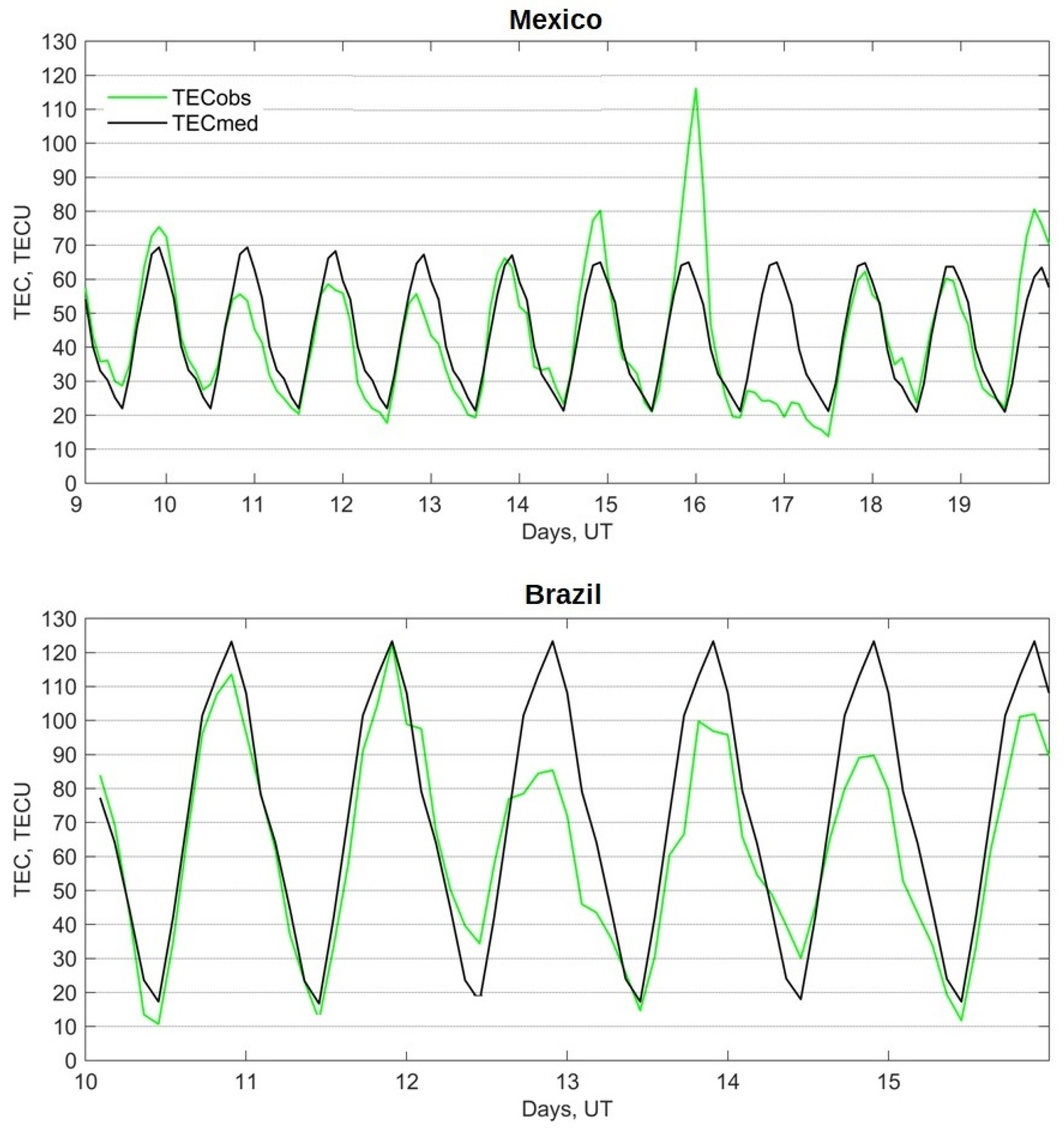
In regard to ionospheric storms, the regular (systematic) variation knowledge on a regional scale is important, as high TEC values exceeding thresholds can be not only the product of disturbance, but also a part of a regular trend. The absolute TEC value’s dependence on the calculation method is probably not very important for the detection of severe event (175 TECU threshold suggested by the ICAO). Still, it may play some role in a moderate event’s detection (125 TECU), especially during periods of high, regular TEC values due to TEC’s systematic variations at a particular observation point. The higher the thresholds, the lower the uncertainty about exceeding them.
-
For the example of Mexico, the suggested approach results in the severe flare’s threshold by the ICAO (X ≥ 10), if the possible number of issued messages is considered to be once in approximately five years. In addition, it was shown that, statistically, for the last two solar cycles, the more flares produced by the same AR, the greater the probability of a severe flare event. The AR already responsible for three flares of X-class seems promising in terms of a significant (X ≥ 10) for an SW service flare event.
-
The flare intensity defined in terms of the X-ray class of the flares is insufficient to estimate either the effects on HF communications or the SEP event’s occurrence. There also needs to have more than the Dst-index to estimate the possibility of a cosmic rays’ event caused by a geomagnetic storm.
-
It is suggested that the particle precipitation risk estimation by the national SW services is considered not regionally, but as a global event. In other words, in the case of cosmic rays, it is suggested that a national SW service assesses radiation risks globally, as the SWXC.
Finally, we emphasize the importance of the statistics collected on physical events and technology outages, as well as the close collaboration and data sharing between the researchers, operational SW services and industry sectors. This will provide more ideas for approaching the current SW challenges.

Author Contributions

Conceptualization, M.A.S. and J.A.G.-E.; methodology, M.A.S. and J.A.G.-E.; data acquisition, V.J.G.-A., E.A.-R. and A.M.-M.; data processing and validation, I.D.O.-L., J.C.M.-A. and J.J.G.-A.; data analysis, M.A.S., L.X.G. and P.C.-R.; visualization, V.J.G.-A. and A.M.-M.; resources, J.A.G.-E.; writing—original draft preparation, M.A.S. and J.A.G.-E. All authors have read and agreed to the published version of the manuscript.

Funding

LANCE acknowledges partial support from the CONAHCyT-AEM, Grant 2017-01-292684, CONAHCyT LN-315829 and PAPIIT IN116023. L.X. Gonzalez was supported by the CONAHCyT-AEM Grant AEM-2018-01-A3-S-63804. E. Aguilar-Rodriguez was supported by the DGAPA/PAPIIT project IN103821. P. Corona-Romero is grateful for the Investigadores por México-CONAHCYT (Catedras CONAHCYT) project 1045 Space Weather Service, financed by the Consejo Nacional de Humanidades Ciencia y Tecnología (CONAHCYT). J.J. Gonzalez-Aviles acknowledges to CONAHCyT 319216 project “Modalidad: Paradigmas y Controversias de la Ciencia 2022”. V.J. Gatica-Acevedo and A. Melgarejo-Morales express their gratitude to the CONAHCyT.

Data Availability Statement

The OMNI data (Dst and F10.7 indices) were obtained from the GSFC/SPDF OMNIWeb interface at https://omniweb.gsfc.nasa.gov (accessed on 25 December 2022). The authors also thank the NOAA’s National Centers for Environmental Information and the NOAA’s Space Weather Prediction Center for the opportunity to use the GOES satellite data available at https://data.ngdc.noaa.gov/platforms/solar-space-observing-satellites/goes/ (accessed on 25 December 2022) and at www.swpc.noaa.gov/products/goes-x-ray-flux (accessed on 25 December 2022), correspondingly. The GIM TEC data provided by IGS were obtained from https://cddis.nasa.gov/archive/gnss/products/ionex (accessed on 13 March 2023).

Acknowledgments

The authors thank the NOAA’s National Centers for Environmental Information for the opportunity to download the GOES satellite data. The authors express their gratitude to the services of the IGS for the opportunity of using the IONEX data via the Internet. The authors thank the Editor and the anonymous reviewers for their valuable comments.

Conflicts of Interest

The authors declare no conflict of interest.

References

  1. Buonsanto, M.J. Ionospheric storms—A review. Space Sci. Rev. 1999, 88, 563–601. [Google Scholar] [CrossRef]
  2. Blagoveshchensky, D.V.; MacDougall, J.W.; Piatkova, A.V. Ionospheric effects preceding the October 2003 Halloween storm. J. Atmos. Sol. Terr. Phys. 2006, 68, 821–831. [Google Scholar] [CrossRef]
  3. Kutiev, I.; Tsagouri, I.; Perrone, L.; Pancheva, D.; Mukhtarov, P.; Mikhailov, A.; Lastovicka, J.; Jakowski, N.; Buresova, D.; Blanch, E.; et al. Solar activity impact on the Earth’s upper atmosphere. J. Space Weather Space Clim. 2013, 3, A06. [Google Scholar] [CrossRef]
  4. Laštovička, J. Lower ionosphere response to external forcing: A brief review. Adv. Space Res. 2009, 43, 1–14. [Google Scholar] [CrossRef]
  5. Karan, D.K.; Eastes, R.W.; Daniell, R.E.; Martinis, C.R.; McClintock, W.E. GOLD mission’s observation about the geomagnetic storm effects on the nighttime equatorial ionization anomaly (EIA) and equatorial plasma bubbles (EPB) during a solar minimum equinox. Space Weather 2023, 21, e2022SW003321. [Google Scholar] [CrossRef]
  6. Huang, C.-S.; Zhang, Y.; Wang, W.; Lin, D.; Wu, Q. Behaviors of ionospheric topside ion density, ion temperature, and electron temperature during the 20 November 2003 superstorm. J. Geophys. Res. Space. Phys. 2022, 127, e2022JA030468. [Google Scholar] [CrossRef]
  7. Yu, T.; Wang, W.; Ren, Z.; Yue, J.; Yue, X.; He, M. Middle-low latitude neutral composition and temperature responses to the 20 and 21 November 2003 superstorm from GUVI dayside Limb measurements. J. Geophys. Res. Space Phys. 2021, 126, e2020JA028427. [Google Scholar] [CrossRef]
  8. Sergeeva, M.A. Space Weather General Concepts. In Space Weather Impact on GNSS Performance; Springer: Cham, Switzerland, 2022; pp. 89–150. [Google Scholar] [CrossRef]
  9. Cannon, P. Extreme Space Weather: Impacts on Engineered Systems and Infrastructure; Royal Academy of Engineering, Prince Philip House: London, UK, 2013; ISBN 1-903496-95-0. Available online: https://www.raeng.org.uk/spaceweather (accessed on 13 March 2023).
  10. National Research Council. Severe Space Weather Events—Understanding Societal and Economic Impacts, Workshop Report; National Academies Press: Washington, DC, USA, 2009; ISBN 13: 978-0-309-13811-6; Available online: https://nap.nationalacademies.org/read/12643/chapter/1 (accessed on 13 March 2023).
  11. Moldwin, M. The technological impacts of space storms. In An Introduction to Space Weather; Cambridge University Press: Cambridge, UK, 2008; pp. 79–94. [Google Scholar] [CrossRef]
  12. Baker, D.; Bodeau, J.M.; Cameron, E.; Fennell, J.F.; Fisher, G.M.; Forbes, K.F.; Kintner, P.L.; Leffler, L.G.; Lewis, W.S.; Reagan, J.B.; et al. Severe Space Weather Events—Understanding Societal and Economic Impacts; The National Academy Press: Washington, DC, USA, 2008. [Google Scholar]
  13. Bothmer, V.; Daglis, I.A. Space Weather—Physics and Effects; Springer: Berlin/Heidelberg, Germany, 2007. [Google Scholar]
  14. Mann, I.R.; Di Pippo, S.; Opgenoorth, H.J.; Kuznetsova, M.; Kendall, D.J. International collaboration within the United Nations Committee on the Peaceful Uses of Outer Space: Framework for international space weather services (2018–2030). Space Weather 2018, 16, 428–433. [Google Scholar] [CrossRef]
  15. UNDRR. Hazard Definition and Classification Review (Technical Report). 2020. Available online: https://www.undrr.org/quick/12955 (accessed on 20 September 2023).
  16. UNDRR. Hazard Information Profiles (HIPs). 2020. Available online: https://www.undrr.org/quick/66872 (accessed on 20 September 2023).
  17. WMO. 2023. Available online: https://community.wmo.int/en/activity-areas/wmo-space-programme-wsp/space-weather-introduction (accessed on 20 September 2023).
  18. Schrijver, C.J.; Kauristie, K.; Aylward, A.D.; Denardini, C.M.; Gibson, S.E.; Glover, A.; Gopalswamy, N.; Grande, M.; Hapgood, M.; Heynderickx, D.; et al. Understanding space weather to shield society: A global road map for 2015–2025 commissioned by COSPAR and ILWS. Adv. Space Res. 2015, 15, 2745–2807. [Google Scholar] [CrossRef]
  19. Simpson, S. Europe to develop new space weather services. Space Weather 2003, 1-2, 1–2. [Google Scholar] [CrossRef]
  20. Belehaki, A.; Watermann, J.; Lilensten, J.; Glover, A.; Hapgood, M.; Messerotti, M.; Van der Linden, R.; Lundstedt, H. Renewed support dawns in Europe: An action to develop space weather products and services. Space Weather 2009, 7. [Google Scholar] [CrossRef]
  21. Onsager, T. Advancing space weather services through international coordination. Space Weather 2012, 10. [Google Scholar] [CrossRef]
  22. Kotzé, P.B.; Cilliers, P.J.; Sutcliffe, P.R. The role of SANSA’s geomagnetic observation network in space weather monitoring: A review. Space Weather 2015, 13, 656–664. [Google Scholar] [CrossRef]
  23. Lanabere, V.; Dasso, S.; Gulisano, A.M.; López, V.E.; Niemelä-Celeda, A.E. Space weather service activities and initiatives at LAMP (Argentinean Space Weather Laboratory group). Adv. Space Res. 2020, 65, 2223–2234. [Google Scholar] [CrossRef]
  24. Lam, H.-L. From Early Exploration to Space Weather Forecasts: Canada’s Geomagnetic Odyssey. Space Weather 2011, 9. [Google Scholar] [CrossRef]
  25. Ahn, B.-H. South Korea’s renewed focus on Space Weather. Space Weather 2011, 9. [Google Scholar] [CrossRef]
  26. Nagatsuma, T. New Ages of Operational Space Weather Forecast in Japan. Space Weather 2013, 11, 207–210. [Google Scholar] [CrossRef]
  27. Wilkinson, P. Space Weather Studies in Australia. Space Weather 2009, 7. [Google Scholar] [CrossRef]
  28. Ishii, M.; Shiota, D.; Tao, C.; Ebihara, Y.; Fujiwara, H.; Ishii, T.; Ichimoto, K.; Kataoka, R.; Koga, K.; Kubo, Y.; et al. Space weather benchmarks on Japanese society. Earth Planets Space 2021, 73, 108. [Google Scholar] [CrossRef]
  29. Jones, J.B.L.; Bentley, R.D.; Hunter, R.; Iles, R.H.A.; Taylor, G.C.; Thomas, D.J. Space weather and commercial airlines. Adv. Space Res. 2005, 36, 2258–2267. [Google Scholar] [CrossRef]
  30. Doc 10100. Manual on Space Weather Information in Support of International Air Navigation, 1st ed.; ICAO Publications: Montreal, QB, Canada, 2019; ISBN 978-92-9258-784-0. [Google Scholar]
  31. Geomagnetic Storms. As a Contribution to the OECD Project―Future Global Shocks; Centra Technology, Inc.: Burlington, MA, USA, 2011; 69p, Available online: http://www.oecd.org/gov/risk/46891645.pdf (accessed on 13 March 2023).
  32. Service Assessment. Intense Space Weather Storms 19 October–7 November 2003; NOAA, National Weather Service: Silver Spring, MD, USA, 2004; 50p. Available online: http://www.weather.gov/media/publications/assessments/SWstorms_assessment.pdf (accessed on 13 March 2023).
  33. Koskinen, H.; Tanskanen, E.; Pirjola, A.E.R.; Pulkkinen, A.; Dyer, C.; Rodgers, D.; Cannon, P.; Mandeville, J.-C.; Boscher, D. Space Weather Effects Catalogue, 2001, ESWS-FMI-RP-0001 (2.2). Available online: http://www.spaceweather.org/ISES/swxeff/1.pdf (accessed on 13 March 2023).
  34. Oughton, E.J. The Economic Impact of Critical National Infrastructure Failure Due to SPACE weather. In Oxford Research Encyclopedia of Natural Hazard Science; Oxford University Press: New York, NY, USA, 2018. [Google Scholar] [CrossRef]
  35. Eastwood, J.P.; Biffis, E.; Hapgood, M.A.; Green, L.; Bisi, M.M.; Bentley, R.D.; Wicks, R.; McKinnell, L.-A.; Gibbs, M.; Burnett, C. The economic impact of space weather: Where do we stand? Risk Anal. 2017, 37, 206–218. [Google Scholar] [CrossRef]
  36. Annex 3: Meteorological Service for International Air Navigation, 20th ed.; ICAO Publications: Montreal, QB, Canada, 2018.
  37. Dissemination of Space Weather Advisories. ICAO Publications. 2019. Available online: https://www.icao.int/airnavigation/METP/Panel%20Documents/SWXA_Additional%20Information.pdf (accessed on 13 March 2023).
  38. The Establishment of China/Russian Federation Consortium for ICAO Designated Space Weather Center; Assembly—40th Session; ICAO Publications: Montreal, QB, Canada, 2019; Available online: https://www.icao.int/Meetings/a40/Documents/WP/wp_336_en.pdf (accessed on 13 March 2023).
  39. ACFJ Services for Aviation. Available online: https://www.swpc.noaa.gov/sites/default/files/images/u59/05%20David%20Boteler%20Official.pdf (accessed on 13 March 2023).
  40. Kauristie, K.; Andries, J.; Beck, P.; Berdermann, J.; Berghmans, D.; Cesaroni, C.; De Donder, E.; de Patoul, J.; Dierckxsens, M.; Doornbos, E.; et al. Space weather services for civil aviation—Challenges and solutions. Remote Sens. 2021, 13, 3685. [Google Scholar] [CrossRef]
  41. Bain, H.M.; Steenburgh, R.A.; Onsager, T.G.; Stitely, E.M. A summary of national oceanic and atmospheric administration space weather prediction center proton event forecast performance and skill. Space Weather 2021, 19, e2020SW002670. [Google Scholar] [CrossRef]
  42. Crown, M.D. Validation of the NOAA space weather prediction center’s solar flare forecasting look-up table and forecaster-issued probabilities. Space Weather 2012, 10, 760. [Google Scholar] [CrossRef]
  43. Kholodkov, K.; Aleshin, I.; Arakelov, A.; Burov, V.; Vasiliev, A.; Ivanov, S. Sino-Russian space weather effort for global air navigation safety. Russ. J. Earth Sci. 2021, 21, 77. [Google Scholar] [CrossRef]
  44. Aleshin, I.M.; Arakelov, A.S.; Bruevich, E.A.; Burov, V.A.; Ivanov, S.D.; Ochelkov, Y.P.; Repin, A.Y.; Kholodkov, K.I. Methods for monitoring strong space weather disturbances to support international air navigation. Russ. Meteorol. Hydrol. 2021, 46, 205–211. [Google Scholar] [CrossRef]
  45. Davies, K.; Hartmann, G.K. Studying the ionosphere with the global positioning system. Radio. Sci. 1997, 199732, 1695–1703. [Google Scholar] [CrossRef]
  46. Afraimovich, E.L.; Perevalova, N.P. GPS-Monitoring of Earth Upper Atmosphere; Russian Academy of Sciences, Siberian Branch: Irkutsk, Russia, 2006; p. 460. ISBN 5-98277-033-7.
  47. Blagoveshchensky, D.V.; Maltseva, O.A.; Sergeeva, M.A. Impact of magnetic storms on the global TEC distribution. Ann. Geophys. 2018, 36, 1071. [Google Scholar] [CrossRef]
  48. Mendillo, M. Storms in the ionosphere: Patterns and processes for total electron content. Rev. Geophys. 2006, 44, 1114. [Google Scholar] [CrossRef]
  49. Tsagouri, I.; Koutroumbas, K.; Elias, P. A new short-term forecasting model for the total electron content storm time disturbances. J. Space Weather Space Clim. 2018, 8, A33. [Google Scholar] [CrossRef]
  50. Klobuchar, J.A. Ionospheric time-delay algorithm for single-frequency GPS users. IEEE Trans. Aerosp. Electron. Syst. 1987, 3, 325–331. [Google Scholar] [CrossRef]
  51. Prieto-Cerdeira, R.; Orús-Pérez, R.; Breeuwer, E.; Lucas-Rodriguez, R.; Falcone, M. Performance of the Galileo single-frequency ionospheric correction during in-orbit validation. GPS World 2014, 25, 53–58. [Google Scholar]
  52. Yuan, Y.; Wang, N.; Li, Z.; Huo, X. The BeiDou global broadcast ionospheric delay correction model (BDGIM) and its preliminary performance evaluation results. Navigation 2019, 66, 55–69. [Google Scholar] [CrossRef]
  53. Nikitina, L.; Fiori, R.A.D.; Ghoddousi-Fard, R.; Waddington, G.H. Statistical analysis of large and extreme global ionospheric total electron content. J. Atm. Sol-Ter. Phys. 2022, 229, 105841. [Google Scholar] [CrossRef]
  54. Goodman, J.M. Operational communication systems and relationships to the ionosphere and Space Weather. Adv. Space Res. 2005, 36, 2241–2252. [Google Scholar] [CrossRef]
  55. Demyanov, V.; Yasyukevich, Y. Space weather: Risk factors for Global Navigation Satellite Systems. Sol-Terr. Phys. 2021, 7, 28–47. [Google Scholar] [CrossRef]
  56. Gonzalez, W.D.; Joselyn, J.A.; Kamide, D.; Kroehl, H.W.; Rostoker, G.; Tsurutani, B.T.; Vasyliunas, V.M. What is a geomagnetic storm? J. Geophys. Res. 1994, 99, 5771–5792. [Google Scholar] [CrossRef]
  57. Loewe, C.A.; Prölss, G.W. Classification and mean behavior of magnetic storms. J. Geophys. Res. 1997, 102, 14209–14213. [Google Scholar] [CrossRef]
  58. Poppe, B.; Onsager, T.G.; Murtagh, W. Halloween storms star in space weather week 2004 meeting. Space Weather 2004, 2. [Google Scholar] [CrossRef]
  59. Sugiura, M.; Kamei, T. Equatorial Dst Index 1957–1986. In IAGA Bulletin; IUGG: Paris, France, 1991; p. 40. [Google Scholar]
  60. Sugiura, M. Hourly Values of Equatorial Dst for the IGY, Annual International Geophysics Year; Pergamon Press: Oxford, UK, 1964; Volume 35, p. 9. [Google Scholar]
  61. Sergeeva, M.A.; Maltseva, O.A.; Gonzalez-Esparza, J.A.; De la Luz, V.; Corona-Romero, P. Features of TEC behaviour over the low-latitude North-American region during the period of medium solar activity. Adv. Space Res. 2017, 60, 1594–1605. [Google Scholar] [CrossRef]
  62. Gonzalez-Esparza, J.A.; De la Luz, V.; Corona-Romero, P.; Mejia-Ambriz, J.C.; Gonzalez, L.X.; Sergeeva, M.A.; Romero-Hernandez, E.; Aguilar-Rodriguez, E. Mexican space weather service (SCIESMEX). Space Weather 2017, 15, 3–11. [Google Scholar] [CrossRef]
  63. Li, W.; Wang, K.; Yuan, K. Performance and Consistency of Final Global Ionospheric Maps from Different IGS Analysis Centers. Remote Sens. 2023, 15, 1010. [Google Scholar] [CrossRef]
  64. Chen, P.; Liu, H.; Ma, Y.; Zheng, N. Accuracy and consistency of different global ionospheric maps released by IGS ionosphere associate analysis centers. Adv. Space Res. 2020, 65, 163–174. [Google Scholar] [CrossRef]
  65. Hernández-Pajares, M.; Juan, J.M.; Sanz, J.; Orus, R.; Garcia-Rigo, A.; Feltens, J.; Komjathy, A.; Schaer, S.C.; Krankowski, A. The IGS VTEC maps: A reliable source of ionospheric information since 1998. J. Geod. 2009, 83, 263–275. [Google Scholar] [CrossRef]
  66. Arikan, F.; Erol, C.B.; Arikan, O. Regularized estimation of vertical total electron content from Global Positioning System data. J. Geophys. Res. 2003, 108, 1469. [Google Scholar] [CrossRef]
  67. Syrovatskiy, S.V.; Yasyukevich, Y.V.; Vesnin, A.M.; Edemskiy, I.K.; Voeykov, S.V.; Zhivetiev, I.V. The effect of solar flares on the ionosphere of the Earth during 24th cycle of solar activity. Mem. Fac. Phys. Mosc. Univ. 2018, 4. [Google Scholar]
  68. Dmitriev, A.V.; Yeh, H.-C.; Chao, J.-K.; Veselovsky, I.S.; Su, S.-Y.; Fu, C.C. Top-side ionosphere response to extreme solar events. Ann. Geophys. 2006, 24, 1469–1477. [Google Scholar] [CrossRef]
  69. Kunitsyn, V.E.; Nazarenko, M.O.; Nesterov, I.A.; Padokhin, A.M. Solar Flare Forcing on Ionization of Upper Atmosphere. Comparative Study of Several Major X_Class Events of 23rd and 24th Solar Cycles. Phys. Earth Atmos. Hydrosphere. Mosc. Univ. Phys. Bull. 2015, 70, 312–318. [Google Scholar] [CrossRef]
  70. Le, H.; Liu, L.; Chen, Y.; Wan, W. Statistical analysis of ionospheric responses to solar flares in the solar cycle 23. J. Geophys. Res. Space 2013, 118, 576–582. [Google Scholar] [CrossRef]
  71. Sergeeva, M.A.; Maltseva, O.A.; Vesnin, A.M.; Blagoveshchensky, D.V.; Gatica-Acevedo, V.J.; Gonzalez-Esparza, J.A.; Chernov, A.G.; Orrala-Legorreta, I.D.; Melgarejo-Morales, A.; Gonzalez, L.X.; et al. Solar flare effects observed over Mexico during March. Remote Sens. 2023, 15, 397. [Google Scholar] [CrossRef]
  72. Machol, J.L.; Eparvier, F.G.; Viereck, R.A.; Woodraska, D.L.; Snow, M.; Thiemann, E.; Woods, T.N.; Mc Clintock, W.E.; Mueller, S.; Eden, T.D.; et al. GOES-R Series Solar X-ray and Ultraviolet Irradiance. In GOES-R Series; Elsevier: Amsterdam, The Netherlands, 2020; pp. 233–242. [Google Scholar]
  73. Gaisser, T.; Engel, R.; Resconi, E. Cosmic rays. In Cosmic Rays and Particle Physics; Cambridge University Press: Cambridge, UK, 2016; pp. 1–11. [Google Scholar] [CrossRef]
  74. Valdés-Galicia, J.F.; González, L.X. Solar modulation of low energy galactic cosmic rays in the near-earth space environment. Adv. Space Res. 2016, 57, 1294–1306. [Google Scholar] [CrossRef]
  75. Sako, T.; Watanabe, K.; Muraki, Y.; Matsubara, Y.; Tsujihara, H.; Yamashita, M.; Sakai, T.; Shibata, S.; Valdés-Galicia, J.F.; González, L.X.; et al. Long-lived Solar Neutron Emission in Comparison with Electron-produced Radiation in the 2005 September 7 Solar Flare. Astrophys. J. 2006, 651, L69–L72. [Google Scholar] [CrossRef]
  76. González, L.X.; Valdés-Galicia, J.F.; Sánchez, F.; Muraki, Y.; Sako, T.; Watanabe, K.; Matsubara, Y.; Nagai, Y.; Shibata, S.; Sakai, T.; et al. Re-evaluation of the neutron emission from the solar flare of 7 September 2005, detected by the Solar Neutron Telescope at Sierra Negra. Astrophys. J. 2015, 814, 136. [Google Scholar] [CrossRef]
  77. Muraki, Y.; López, D.; Koga, K.; Kakimoto, F.; Goka, T.; González, L.X.; Masuda, S.; Matsumoto, H.; Mastubara, Y.; Miranda, P.; et al. Simultaneous Observation of Solar Neutrons from the ISS and High Mountain Observatories in Association with a Flare on 8 July 2014. Sol. Phys. 2016, 291, 1241–1265. [Google Scholar] [CrossRef]
Figure 1. The pronounced TEC response to the storm of 15–17 July 2000 (upper panel), and the high TEC reference values before and during the storm of 11–13 April 2001 (lower panel). TECobs stands for the observed value, and TECmed stands for the 27-day running median representing regular variations (reference values).
Remotesensing 15 04839 g001
Figure 2. Maximal TEC values registered during and after the geomagnetic storms characterized by Dstmin < −200 nT (assuming that the accuracy of GIM TEC is about 2–5 TECU), grouped by ranges (upper panel) and semi-ranges (lower panel).
Remotesensing 15 04839 g002
Figure 3. X-class flares occurred between January 1998 and February 2023, during approximately two solar cycles. The black points mark the moments of X-flares whose intensity is given in the left Y-axis. The rose curve stands for the F10.7-index series (right Y-axis).
Remotesensing 15 04839 g003
Figure 4. The number of flares of each X-ray class (left) and the number of flares exceeding a certain intensity level characterized by the X-ray class (right). Daytime events are for Mexico. The covered period is the same as in Figure 3.
Remotesensing 15 04839 g004
Figure 5. The role of an AR’s activity during the time that it is visible on the solar disk. “Number of the same AR” stands for the number of the particular ARs, each of which is responsible for multiple flares.
Remotesensing 15 04839 g005
Table 1. TEC responses to Dst < −200 nT at two observation points. The values that exceeded the SGXC threshold for a moderate storm are marked with a red color.
MEXICOBRAZIL
Dstmin, nTGeomagnetic Storm>100 a TECUTECmax, TECUTEC
Response
Near Regular>100 a TECUTECmax, TECUTEC ResponseNear Regular
−2054–6 May 1998no datano datano datano datano datano datano datano data
−20725–26 September 1998 68.3↑↓ 85-v
−23722–24 October 1999 80.2↑↓v+109.1v
−2926–8 April 2000+165.3 +143.7v
−30015–17 July 2000+116.1↑↓ 83.5
−23412–13 August 2000 78.2↑↓ 87
−20117–19 September 2000(+)96.1 91.3v
−28431–1 March 2001+123.4v+147.5
−27111–13 April 2001+143.4↑↓ +122.7v
−2926–8 November 2001+105.3v+122.8v
−22124–26 November 2001(+)95.9↑↓v+106.3v
−38328–3 October 2003+208.4 +99.2↑↓
−42220–23 November 2003+107.8 81.6↑↓v
−3746–12 November 2004 53.8v 64.4
−24715–16 May 2005 46.1v 61.2
−22517–19 March 2015 71.5↑↓v 93.6↑↓
a The column is filled assuming that the accuracy of GIM TEC is about 2–5 TECU. The sign (+) is used when the value was close to 100 TECU. The sign ↑ stands for an increase and ↓ stands for a decrease of TEC. v means that TEC values during and after the storm were close to or defined by their regular variations.
Disclaimer/Publisher’s Note: The statements, opinions and data contained in all publications are solely those of the individual author(s) and contributor(s) and not of MDPI and/or the editor(s). MDPI and/or the editor(s) disclaim responsibility for any injury to people or property resulting from any ideas, methods, instructions or products referred to in the content.

