
Deformation Behavior and Reactivation Mechanism of the Dandu Ancient Landslide Triggered by Seasonal Rainfall: A Case Study from the East Tibetan Plateau, China
 ,
,
Abstract
:1. Introduction
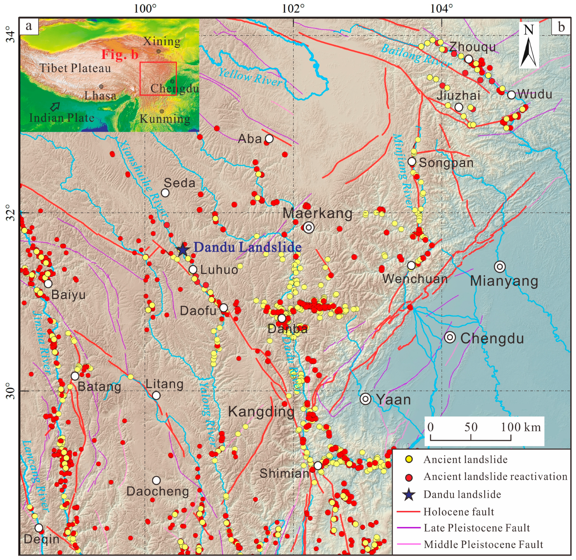
2. Study Area
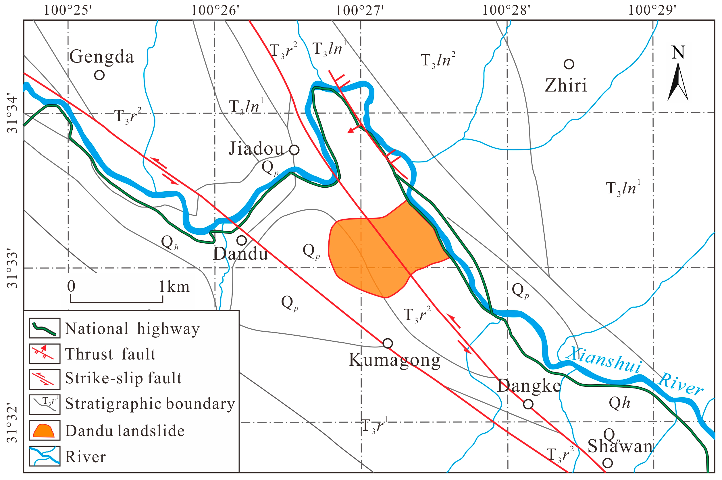
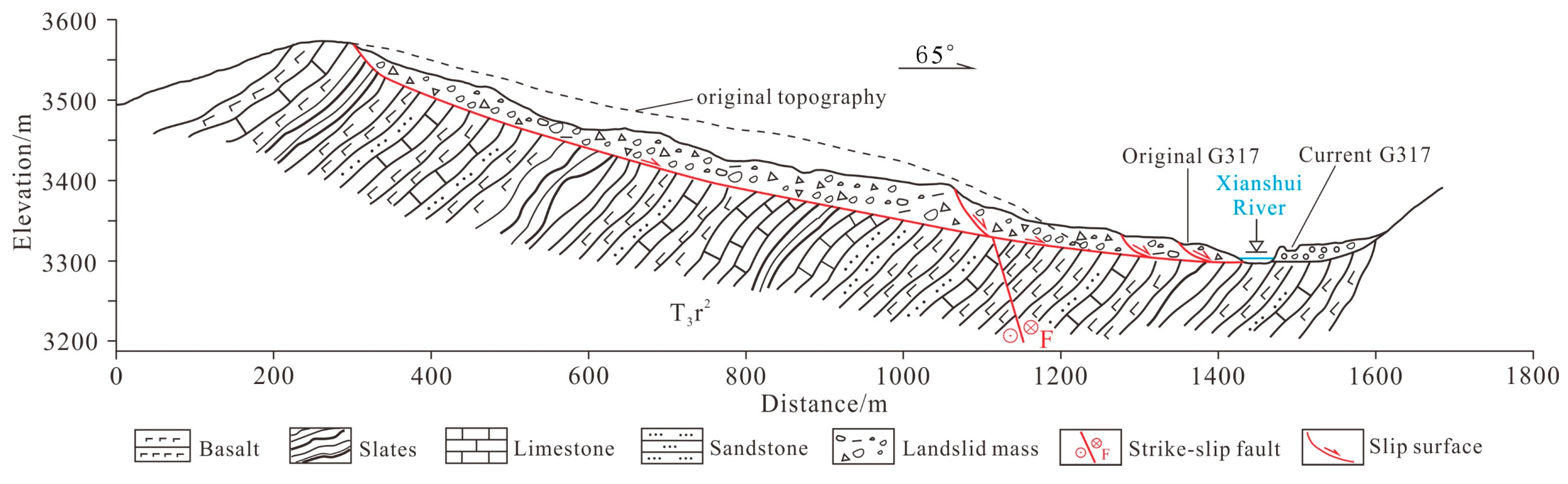
2.1. Geological Setting
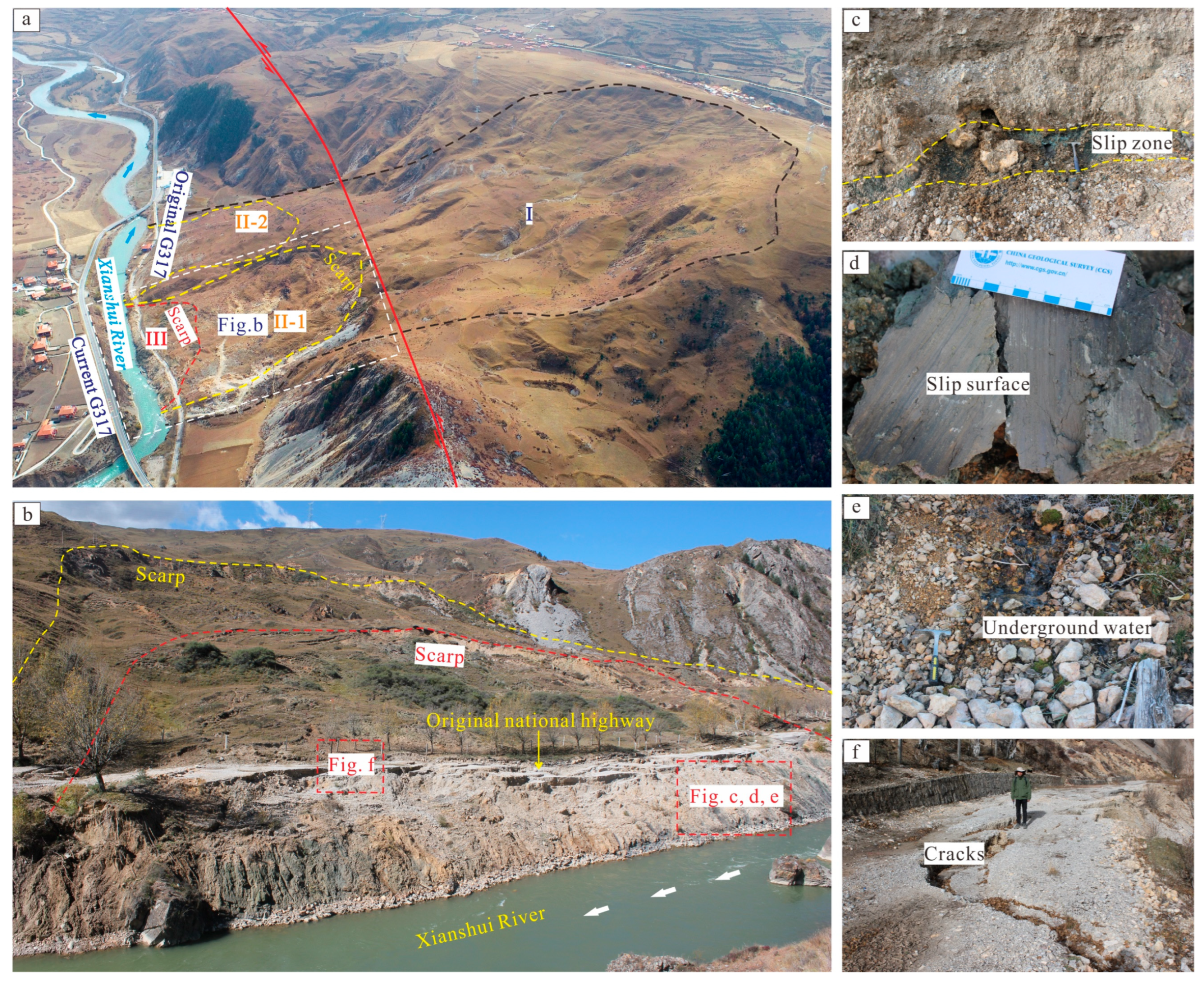
2.2. Features of Ancient Landslide
3. Materials and Methods
3.1. Field Investigation and UAV Photography
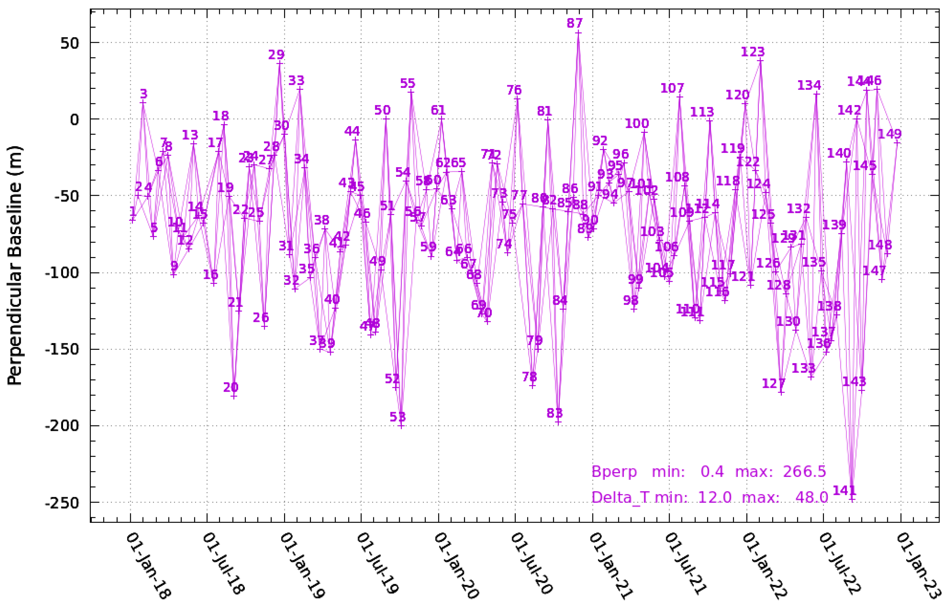
3.2. Deformation Monitoring by InSAR
- (1)
- N + 1 views of SAR images covering the study area were obtained, acquired at times: t0, t1, …, tn. Suitable spatial–temporal baseline thresholds were set to register the slave images with the master images. The interferometric pairs were obtained accordingly, at a number M.
- (2)
- M pairs of interferometric pairs were used to generate time-series interferograms for multi-master images.
- (3)
- The regression algorithm was applied to the deformation dataset to estimate and remove the elevation residuals; the residual phases, such as noise and atmospheric delays, were separated according to the selected combined filter methods.
- (4)
- The deformation time series was reconstructed using the small baseline set time series deformation solution model. With t0 as the reference moment, the differential interferometric phase was acquired during data processing with observed quantities. Time ti was the relative time i to t0 (0 < i < N) and obtained unknown quantities, and the interferometric phase value of the image element (r, c) was:where λ is the radar wavelength and d(tB, r, c,) and d(tA, r, c,) are the deformation of pixels traveling at moments tB and tA along the radar line-of-sight direction, respectively.
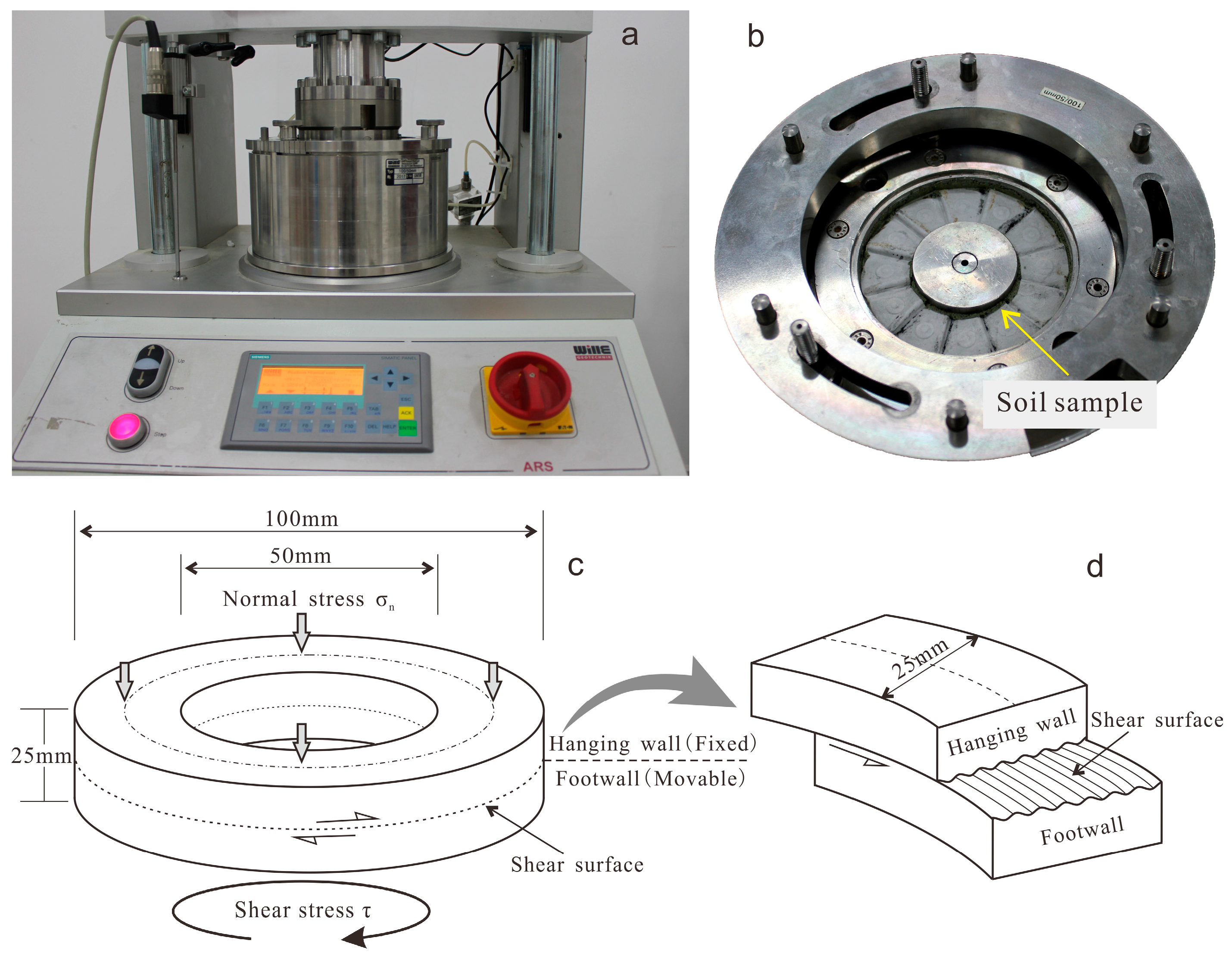
3.3. Ring Shear Test of Slip Zone Soil
4. Results
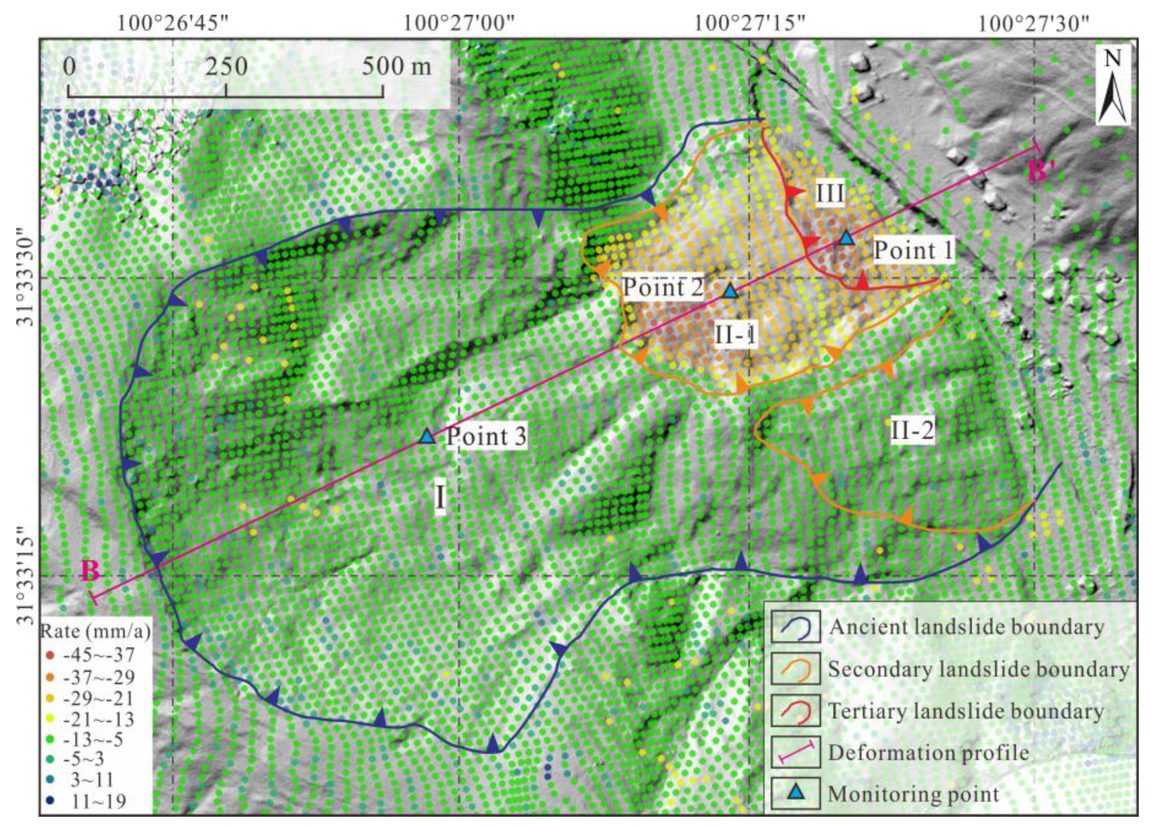
4.1. Reactivation Features and Zonation of the Landslide
4.2. Deformation Characteristics Monitored by InSAR
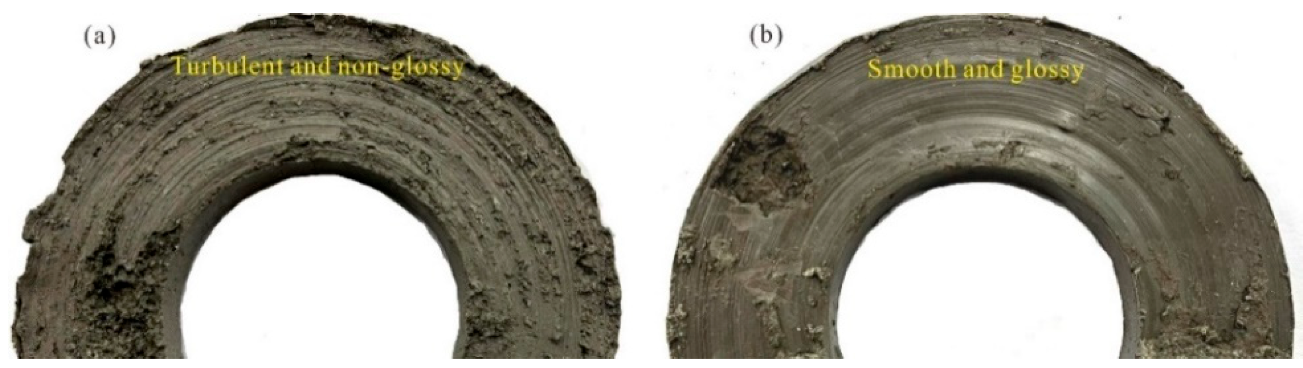
4.3. Shear Strength of the Slip Zone
5. Discussion
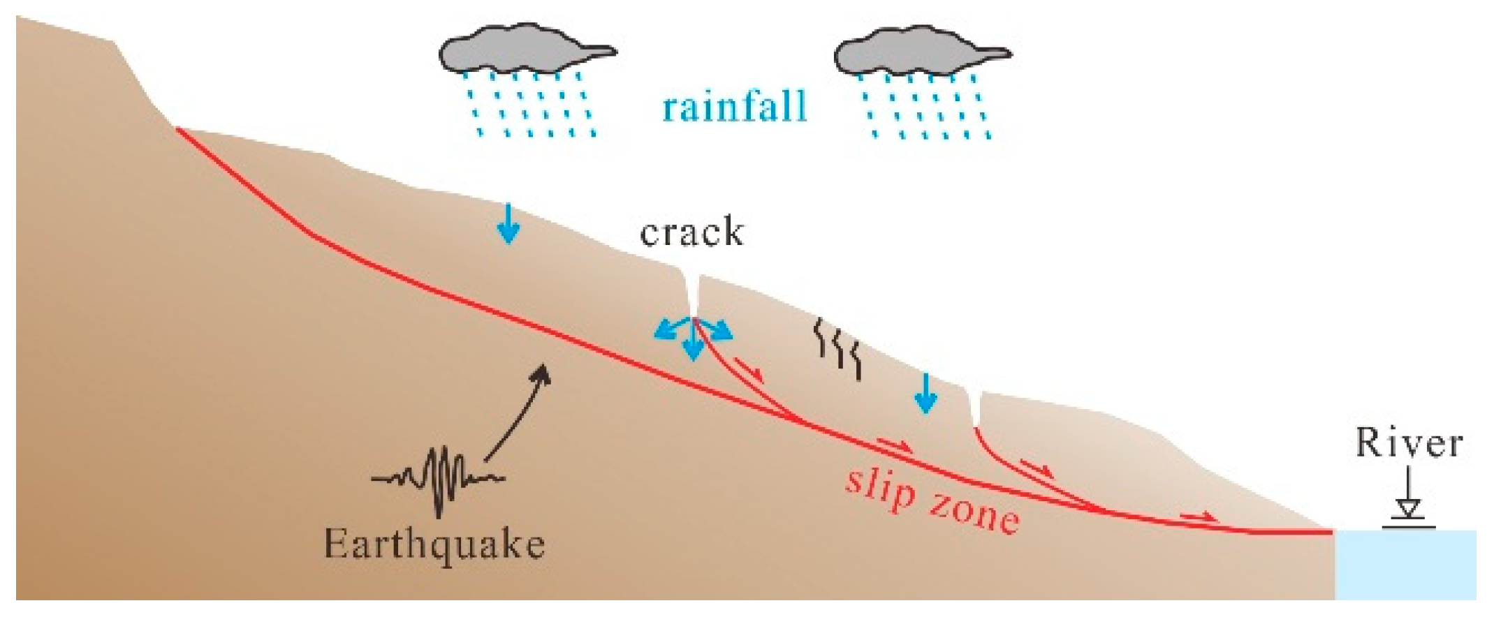
5.1. Active Faults Are the Driving Forces for the Formation of Landslide Cracks
5.2. Pre-Existing Slip Zones Are the Essence of Landslide Reactivation
5.3. Rainfall Is a Trigger Factor for Landslide Reactivation
6. Conclusions
- The reactivation of the Dandu ancient landslides exhibits multiple periods and multiple zones of deformation, with lower-order sequences showing higher deformation rates and poorer stability. The deformation rates in zones III, II-1, and I were 40 mm/a, 20 mm/a, and less than 10 mm/a, respectively.
- The deformation characteristics of the Dandu landslide respond very well to seasonal rainfall. The sliding motion starts to accelerate after the rainy season arrives and decelerates substantially when the dry season arrives. However, this response generally lags by several weeks.
- The cracks in the landslide, formed by fault creeping and seismic activity, provide pathways for rainwater infiltration, ultimately reducing the shear resistance of the slip zone and causing the reactivation and deformation of the Dandu landslide. Meanwhile, rainfall infiltration takes time, which is why the response of landslide deformation to rainfall lags by several weeks.
Author Contributions
Funding
Data Availability Statement
Acknowledgments
Conflicts of Interest
References
- Guo, C.; Montgomery, D.R.; Zhang, Y.; Wang, K.; Yang, Z. Quantitative assessment of landslide susceptibility along the Xianshui fault zone, Tibetan Plateau, China. Geomorphology 2015, 248, 93–110. [Google Scholar] [CrossRef]
- Chen, J.; Zhou, W.; Cui, Z.; Li, W.; Wu, S.; Ma, J. Formation process of a large paleolandslide-dammed lake at Xuelongnang in the upper Jinsha river, SE Tibetan Plateau: Constraints from OSL and 14C dating. Landslides 2018, 15, 2399–2412. [Google Scholar] [CrossRef]
- Bao, Y.; Zhai, S.; Chen, J.; Xu, P.H.; Zhou, X.; Zhan, J.; Zhang, W.; Zhou, X. The evolution of the Samaoding paleo landslide river blocking event at the upper reaches of the Jinsha river, Tibetan Plateau. Geomorphology 2019, 351, 106970. [Google Scholar]
- Lacroix, P.; Handwerger, A.L.; Bièvre, G. Life and death of slow-moving landslides. Nat. Rev. Earth Environ. 2020, 1, 404–419. [Google Scholar] [CrossRef]
- García-Delgado, H. The San Eduardo Landslide (Eastern Cordillera of Colombia): Reactivation of a deep-seated gravitational slope deformation. Landslides 2020, 17, 1951–1964. [Google Scholar] [CrossRef]
- Guo, C.; Zhang, Y.; Li, X.; Ren, S.; Yang, Z.; Wu, R.; Jin, J. Reactivation of giant Jiangdingya ancient landslide in Zhouqu County, Gansu Province, China. Landslides 2020, 17, 179–190. [Google Scholar] [CrossRef]
- He, K.; Ma, G.; Hu, X.; Liu, B. Failure mechanism and stability analysis of a reactivated landslide occurrence in Yanyuan City, China. Landslides 2021, 18, 1097–1114. [Google Scholar] [CrossRef]
- Yang, X.; Jiang, Y.; Zhu, J.; Ding, B.; Zhang, W. Deformation characteristics and failure mechanism of the Moli landslide in Guoye Town, Zhouqu County. Landslides 2023, 20, 789–800. [Google Scholar] [CrossRef]
- Dai, K.; Li, Z.; Xu, Q.; Tomas, R.; Li, T.; Jiang, L.; Zhang, J.; Yin, T.; Wang, H. Identification and evaluation of the high mountain upper slope potential landslide based on multi-source remote sensing: The Aniangzhai landslide case study. Landslides 2023, 20, 1405–1417. [Google Scholar] [CrossRef]
- Xie, M.; Zhao, W.; Ju, N.; He, C.; Huang, H.; Cui, Q. Landslide evolution assessment based on InSAR and real-time monitoring of a large reactivated landslide, Wenchuan, China. Eng. Geol. 2020, 277, 105781. [Google Scholar] [CrossRef]
- Yan, Y.; Guo, C.; Li, C.; Yuan, H.; Qiu, Z. The Creep-Sliding Deformation Mechanism of the Jiaju Ancient Landslide in the Upstream of Dadu River, Tibetan Plateau, China. Remote Sens. 2023, 15, 592. [Google Scholar] [CrossRef]
- Iverson, R.M.; George, D.L.; Allstadt, K.; Reid, M.E.; Collins, B.D.; Vallance, J.W.; Schilling, S.P.; Godt, J.W.; Cannon, C.M.; Magirl, C.S.; et al. Landslide mobility and hazards: Implications of the 2014 Oso disaster. Earth Planet. Sci. Lett. 2015, 412, 197–208. [Google Scholar] [CrossRef]
- Palmer, J. Creeping earth could hold secret to deadly landslides. Nature 2017, 548, 384–386. [Google Scholar] [CrossRef] [PubMed]
- Agliardi, F.; Scuderi, M.M.; Fusi, N.; Collettini, C. Slow-to-fast transition of giant creeping rockslides modulated by undrained loading in basal shear zones. Nat. Commun. 2020, 11, 1352. [Google Scholar] [CrossRef] [PubMed]
- Zhang, Y.; Meng, X.; Novellino, A.; Dijkstra, T.; Chen, G.; Jordan, C.; Li, Y.; Su, X. Characterization of pre-failure deformation and evolution of a large earthflow using InSAR monitoring and optical image interpretation. Landslides 2022, 19, 35–50. [Google Scholar] [CrossRef]
- Bayer, B.; Simoni, A.; Mulas, M.; Corsini, A.; Schmidt, D. Deformation responses of slow moving landslides to seasonal rainfall in the Northern Apennines, measured by InSAR. Geomorphology 2018, 308, 293–306. [Google Scholar] [CrossRef]
- Luna, L.V.; Korup, O. Seasonal landslide activity lags annual precipitation pattern in the Pacific Northwest. Geophys. Res. Lett. 2022, 49, e2022GL098506. [Google Scholar] [CrossRef]
- Liu, Y.; Qiu, H.; Yang, D.; Liu, Z.; Ma, S.; Pei, Y.; Zhang, J.; Tang, B. Deformation responses of landslides to seasonal rainfall based on InSAR and wavelet analysis. Landslides 2022, 19, 199–210. [Google Scholar] [CrossRef]
- Zhao, C.; Kang, Y.; Zhang, Q.; Lu, Z.; Li, B. Landslide identification and monitoring along the Jinsha River catchment (Wudongde reservoir area), China, using the InSAR method. Remote Sens. 2018, 10, 993. [Google Scholar] [CrossRef]
- Casu, F.; Manzo, M.; Lanari, R. A quantitative assessment of the SBAS algorithm performance for surface deformation retrieval from DInSAR data. Remote Sens. Environ. 2006, 102, 195–210. [Google Scholar] [CrossRef]
- Ferretti, A.; Savio, G.; Barzaghi, R.; Borghi, A.; Musazzi, S.; Novali, F.; Prati, C.; Rocca, F. Submillimeter Accuracy of InSAR Time Series: Experimental Validation. IEEE Trans. Geosci. Remote Sens. 2007, 45, 1142–1153. [Google Scholar] [CrossRef]
- Tizzani, P.; Berardino, P.; Casu, F.; Euillades, P.; Manzo, M.; Ricciardi, G.P.; Zeni, G.; Lanari, R. Surface deformation of Long Valley caldera and Mono Basin, California, investigated with the SBAS-InSAR approach. Remote Sens. Environ. 2007, 108, 277–289. [Google Scholar] [CrossRef]
- Zhu, Y.; Yao, X.; Yao, L.; Zhou, Z.; Ren, K.; Li, L.; Yao, C.; Gu, Z. Identifying the Mechanism of Toppling Deformation by InSAR: A Case Study in Xiluodu Reservoir, Jinsha River. Landslides 2022, 19, 2311–2327. [Google Scholar] [CrossRef]
- Su, X.; Zhang, Y.; Meng, X.; Rehman, M.U.; Khalid, Z.; Yue, D. Updating Inventory, Deformation, and Development Characteristics of Landslides in Hunza Valley, NW Karakoram, Pakistan by SBAS-InSAR. Remote Sens. 2022, 14, 4907. [Google Scholar] [CrossRef]
- Sandwell, D.; Price, E. Phase gradient approach to stacking interferograms. J. Geophys. Res. Solid Earth 1998, 103, 30183–30204. [Google Scholar] [CrossRef]
- Turner, D.; Lucieer, A.; De Jong, S.M. Time Series Analysis of Landslide Dynamics Using an Unmanned Aerial Vehicle (UAV). Remote Sens. 2015, 7, 1736–1757. [Google Scholar] [CrossRef]
- Handwerger, A.L.; Fielding, E.J.; Huang, M.H.; Bennett, G.L.; Liang, C.; Schulz, W.H. Widespread initiation, reactivation and acceleration of landslides in thenorthern California Coast Ranges dueto extreme rainfall. J. Geophys. Res. Earth Surf. 2019, 124, 1782–1797. [Google Scholar] [CrossRef]
- Schulz, W.H.; Wang, G. Residual shear strength variability as a primarycontrol on movement of landslides reactivated by earthquake-induced groundmotion: Implications for coastal Oregon, U.S. J. Geophys. Res. Earth Surf. 2014, 119, 1617–1635. [Google Scholar] [CrossRef]
- Skempton, A.W. Residual strength of clays in landslides, folded strata and the laboratory. Géotechnique 1985, 35, 3–18. [Google Scholar] [CrossRef]
- Di Maio, C.; Scaringi, G.; Vassallo, R. Residual strength and creep behaviour on the slip surface of specimens of a landslide in marine origin clay shales: Influence of pore fluid composition. Landslides 2015, 12, 657–667. [Google Scholar] [CrossRef]
- Wen, B.P.; Jiang, X.Z. Effect of gravel content on creep behavior of clayey soil at residual state: Implication for its role in slow-moving landslides. Landslides 2017, 14, 559–576. [Google Scholar] [CrossRef]
- Sassa, K.; Fukuoka, H.; Wang, G.; Ishikawa, N. Undrained dynamic-loading ring-shear apparatus and its application to landslide dynamics. Landslides 2004, 1, 1–5. [Google Scholar] [CrossRef]
- Hu, W.; Li, Y.; Xu, Q.; Huang, R.; McSaveney, M.; Wang, G.; Fan, Y.; Wasowski, J.; Zheng, Y. Flowslide high fluidity induced by shear-thinning. J. Geophys. Res. Solid Earth 2022, 127, e2022JB024615. [Google Scholar] [CrossRef]
- Bai, M.; Chevalier, M.L.; Pan, J.; Replumaz, A.; Philippe, H.L.; Marianne, M.; Li, H. Southeastward increase of the late Quaternary slip-rate of the Xianshui fault, eastern Tibet. Geodynamic and seismic hazard implications. Earth Planet. Sci. Lett. 2018, 485, 19–31. [Google Scholar] [CrossRef]
- Zhang, Y.; Yao, X.; Yu, K.; Du, G.; Guo, C. Late-Quaternary slip rate and seismic activity of the Xianshui fault zone. Acta Geol. Sin. 2016, 90, 525–536. [Google Scholar] [CrossRef]
- Chevalier, M.L.; Leloup, P.H.; Replumaz, A.; Pan, J.; Métois, M.; Li, H. Temporally constant slip rate along the Ganzi fault, NW Xianshui fault system, eastern Tibet. GSA Bull. 2017, 130, 396–410. [Google Scholar] [CrossRef]
- Liu, X.; Zhang, Y.; Guo, C.; Wu, R.; Ren, S.; Shen, Y. Development characteristics and evolution process of the Garazong ancient rockslide along the Xianshuihe River in western Sichuan. Acta Geol. Sin. 2019, 93, 1767–1777, (In Chinese with English Abstract). [Google Scholar]
- Hungr, O.; Leroueil, S.; Picarelli, L. The Varnes classification of landslide types, an update. Landslides 2014, 11, 167–194. [Google Scholar] [CrossRef]
- Cruden, D.M.; Varnes, D.J. Landslide types and processes. In Landslides Investigation and Mitigation; Turner, A.K., Schuster, R.L., Eds.; Special Report 247; Transportation Research Board, US National Research Council: Washington, DC, USA, 1996; Chapter 3; pp. 36–75. [Google Scholar]
- Berardino, P.; Fornaro, G.; Lanari, R.; Sansosti, E. A new algorithm for surface deformation monitoring based on small baseline differential SAR interferograms. IEEE Trans. Geosci. Remote Sens. 2002, 40, 2375–2383. [Google Scholar] [CrossRef]
- Ren, S.; Zhang, Y.; Li, J.; Li, J.; Liu, X.; Wu, R. A new type of sliding zone soil and its severe effect on the formation of giant landslides in the Jinsha River tectonic suture zone, China. Nat. Hazards 2023, 117, 1847–1868. [Google Scholar] [CrossRef]
- GB/T50123-2019; Standard for Geotechnical Testing Method. National Standard of the People’s Republic of China: Beijing, China, 2019. (In Chinese)
- Scheingross, J.S.; Minchew, B.M.; Mackey, B.H. Fault-zone controls on the spatial distribution of slow-moving landslides. Geol. Soc. Am. Bull. 2013, 125, 473–489. [Google Scholar] [CrossRef]
- Zhang, Y.; Ren, S.; Liu, X.; Guo, C.; Li, J.; Bi, J.; Ran, L. Reactivation mechanism of old landslide triggered by coupling of fault creep and water infiltration: A case study from the east Tibetan Plateau. Bull. Eng. Geol. Environ. 2023, 82, 291. [Google Scholar] [CrossRef]
- Yin, Y.; Wang, W.; Zhang, N.; Yan, J.; Wei, Y. The June 2017 Maoxian landslide: Geological disaster in an earthquake area after the Wenchuan Ms 8.0 earthquake. Sci. China Technol. Sci. 2017, 60, 1762–1766. [Google Scholar] [CrossRef]
- Stark, T.D.; Hussain, M. Shear Strength in Preexisting Landslides. J. Geotech. Geoenviron. Eng. 2010, 136, 957–962. [Google Scholar] [CrossRef]
- Ren, S.; Zhang, Y.; Xu, N.; Wu, R.; Liu, X.; Du, G. Mobilized strength of gravelly sliding zone soil in reactivated landslide: A case study of a giant landslide in the north-eastern margin of Tibet Plateau. Environ. Earth Sci. 2021, 80, 434. [Google Scholar] [CrossRef]
- Wang, D.; Xiao, H.; Li, M. Discussion on the reconstruction method of landslide geological model before failure: A case study of Laohuzui landslide in Xianshui Fault Zone. Hydrogeol. Eng. Geol. 2013, 40, 111–116, (In Chinese with English Abstract). [Google Scholar]
- Floris, M.; Bozzano, F. Evaluation of landslide reactivation: A modified rainfall threshold model based on historical records of rainfall and landslides. Geomorphology 2008, 94, 40–57. [Google Scholar] [CrossRef]
- Xu, Y.; Kim, J.; George, D.L.; Lu, Z. Characterizing Seasonally Rainfall-Driven Movement of a Translational Landslide using SAR Imagery and SMAP Soil Moisture. Remote Sens. 2019, 11, 2347. [Google Scholar] [CrossRef]
- Tu, G.; Huang, D.; Deng, H. Reactivation of a huge ancient landslide by surface water infiltration. J. Mt. Sci. 2019, 16, 806–820. [Google Scholar] [CrossRef]
- Tian, S.; Chen, N.; Wu, H.; Yang, C.; Rahman, M. New insights into the occurrence of the baige landslide along the Jinsha river in Tibet. Landslides 2020, 17, 1207–1216. [Google Scholar] [CrossRef]
- Notti, D.; Wrzesniak, A.; Dematteis, N.; Lollino, P.; Fazio, N.L.; Zucca, F.; Giordan, D. A multidisciplinary investigation of deep-seated landslide reactivation triggered by an extreme rainfall event: A case study of the Monesi di Mendatica landslide, Ligurian Alps. Landslides 2021, 18, 2341–2365. [Google Scholar] [CrossRef]


| Satellite | Track | Date Range | Number of Images | Revisit Cycle (Days) | Resolution (m) |
Angle of Incidence
(°) | |
|---|---|---|---|---|---|---|---|
| Azimuth | Range | ||||||
| Sentinel-1 | P26 | 7 January 2018– 24 December 2022 | 149 | 12/24 | 13.98 | 2.33 | 34.71 |
| Dry Density (g/cm3) | Plastic Limit (%) | Liquid Limit (%) | Plasticity Index (IP) | Particle Size Distribution (mm, %) | |||
|---|---|---|---|---|---|---|---|
| <0.005 | 0.005~0.075 | 0.075~2 | >2 | ||||
| 1.80~1.88 | 21.1~21.5 | 37.0~37.7 | 15.9~16.2 | 16 | 26 | 38 | 20 |
| Sample Number | Dry Density ρ (g/cm3) | Normal Stress (σn/kPa) | Initial Water Content | Particle Size Distribution (mm, %) | ||
|---|---|---|---|---|---|---|
| <0.005 | 0.005~0.075 | 0.075~2 | ||||
| DD01 | 1.83 | 100 | 10% | 20 | 33 | 47 |
| DD02 | 1.84 | 200 | ||||
| DD03 | 1.82 | 400 | ||||
| DD04 | 1.84 | 800 | ||||
| DD05 | 1.81 | 100 | Saturated | |||
| DD06 | 1.82 | 200 | ||||
| DD07 | 1.80 | 400 | ||||
| DD08 | 1.80 | 800 | ||||
Disclaimer/Publisher’s Note: The statements, opinions and data contained in all publications are solely those of the individual author(s) and contributor(s) and not of MDPI and/or the editor(s). MDPI and/or the editor(s) disclaim responsibility for any injury to people or property resulting from any ideas, methods, instructions or products referred to in the content. |
© 2023 by the authors. Licensee MDPI, Basel, Switzerland. This article is an open access article distributed under the terms and conditions of the Creative Commons Attribution (CC BY) license (https://creativecommons.org/licenses/by/4.0/).
Share and Cite
Ren, S.; Zhang, Y.; Li, J.; Zhou, Z.; Liu, X.; Tao, C. Deformation Behavior and Reactivation Mechanism of the Dandu Ancient Landslide Triggered by Seasonal Rainfall: A Case Study from the East Tibetan Plateau, China. Remote Sens. 2023, 15, 5538. https://doi.org/10.3390/rs15235538
Ren S, Zhang Y, Li J, Zhou Z, Liu X, Tao C. Deformation Behavior and Reactivation Mechanism of the Dandu Ancient Landslide Triggered by Seasonal Rainfall: A Case Study from the East Tibetan Plateau, China. Remote Sensing. 2023; 15(23):5538. https://doi.org/10.3390/rs15235538
Chicago/Turabian StyleRen, Sanshao, Yongshuang Zhang, Jinqiu Li, Zhenkai Zhou, Xiaoyi Liu, and Changxu Tao. 2023. "Deformation Behavior and Reactivation Mechanism of the Dandu Ancient Landslide Triggered by Seasonal Rainfall: A Case Study from the East Tibetan Plateau, China" Remote Sensing 15, no. 23: 5538. https://doi.org/10.3390/rs15235538
APA StyleRen, S., Zhang, Y., Li, J., Zhou, Z., Liu, X., & Tao, C. (2023). Deformation Behavior and Reactivation Mechanism of the Dandu Ancient Landslide Triggered by Seasonal Rainfall: A Case Study from the East Tibetan Plateau, China. Remote Sensing, 15(23), 5538. https://doi.org/10.3390/rs15235538