
Time-Dependent Systematic Biases in Inferring Ice Cloud Properties from Geostationary Satellite Observations


Abstract
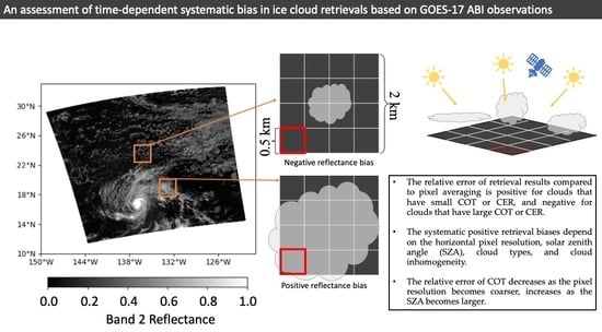
1. Introduction
2. Data and Methodology
2.1. Data and Pixel Selection Criteria
2.2. Resampling Methods
2.3. Resampling Methods
2.4. Off-Nadir Pixel Resolution
3. Results
3.1. Comparison of COT and CER Retrievals among the Resampling Methods
3.2. Impact of Effective Pixel Resolutions
3.3. Temporal Dependence of the Relative Error with Different Types of Clouds
4. Conclusions
Author Contributions
Funding
Data Availability Statement
Acknowledgments
Conflicts of Interest
References
- Hong, Y.; Liu, G.; Li, J.L.F. Assessing the Radiative Effects of Global Ice Clouds Based on CloudSat and CALIPSO Measurements. J. Clim. 2016, 29, 7651–7674. [Google Scholar] [CrossRef]
- Baran, A.J. A Review of the Light Scattering Properties of Cirrus. J. Quant. Spectrosc. Radiat. Transf. 2009, 110, 1239–1260. [Google Scholar] [CrossRef]
- Liou, K.-N.; Yang, P. Light Scattering by Ice Crystals: Fundamentals and Applications; Cambridge University Press: Cambridge, UK, 2016; ISBN 1316712443. [Google Scholar]
- Kahn, B.H.; Takahashi, H.; Stephens, G.L.; Yue, Q.; Delanoë, J.; Manipon, G.; Manning, E.M.; Heymsfield, A.J. Ice Cloud Microphysical Trends Observed by the Atmospheric Infrared Sounder. Atmos. Chem. Phys. 2018, 18, 10715–10739. [Google Scholar] [CrossRef]
- Gong, J.; Zeng, X.; Wu, D.L.; Li, X. Diurnal Variation of Tropical Ice Cloud Microphysics: Evidence from Global Precipitation Measurement Microwave Imager Polarimetric Measurements. Geophys. Res. Lett. 2018, 45, 1185–1193. [Google Scholar] [CrossRef] [PubMed]
- Jiang, J.H.; Su, H.; Zhai, C.; Perun, V.S.; Del Genio, A.; Nazarenko, L.S.; Donner, L.J.; Horowitz, L.; Seman, C.; Cole, J.; et al. Evaluation of Cloud and Water Vapor Simulations in CMIP5 Climate Models Using NASA “A-Train” Satellite Observations. J. Geophys. Res. Atmos. 2012, 117. [Google Scholar] [CrossRef]
- Várnai, T.; Marshak, A. Statistical Analysis of the Uncertainties in Cloud Optical Depth Retrievals Caused by Three-Dimensional Radiative Effects. J. Atmos. Sci. 2001, 58, 1540–1548. [Google Scholar] [CrossRef]
- Platnick, S.; Meyer, K.G.; King, M.D.; Wind, G.; Amarasinghe, N.; Marchant, B.; Arnold, G.T.; Zhang, Z.; Hubanks, P.A.; Holz, R.E.; et al. The MODIS Cloud Optical and Microphysical Products: Collection 6 Updates and Examples from Terra and Aqua. IEEE Trans. Geosci. Remote Sens. 2017, 55, 502–525. [Google Scholar] [CrossRef]
- Mace, G.G.; Zhang, Q. The CloudSat Radar-lidar Geometrical Profile Product (RL-GeoProf): Updates, Improvements, and Selected Results. J. Geophys. Res. Atmos. 2014, 119, 9441–9462. [Google Scholar] [CrossRef]
- Saito, M.; Yang, P.; Hu, Y.; Liu, X.; Loeb, N.; Smith, W.L., Jr.; Minnis, P. An Efficient Method for Microphysical Property Retrievals in Vertically Inhomogeneous Marine Water Clouds Using MODIS-CloudSat Measurements. J. Geophys. Res. Atmos. 2019, 124, 2174–2193. [Google Scholar] [CrossRef]
- Iwabuchi, H.; Putri, N.S.; Saito, M.; Tokoro, Y.; Sekiguchi, M.; Yang, P.; Baum, B.A. Cloud Property Retrieval from Multiband Infrared Measurements by Himawari-8. J. Meteorol. Soc. Jpn. Ser. II 2018, 96B, 27–42. [Google Scholar] [CrossRef]
- Schmit, T.J.; Griffith, P.; Gunshor, M.M.; Daniels, J.M.; Goodman, S.J.; Lebair, W.J. A Closer Look at the ABI on the Goes-r Series. Bull. Am. Meteorol. Soc. 2017, 98, 681–698. [Google Scholar] [CrossRef]
- Liu, Q.; Li, Y.; Yu, M.; Chiu, L.S.; Hao, X.; Duffy, D.Q.; Yang, C. Daytime Rainy Cloud Detection and Convective Precipitation Delineation Based on a Deep Neural Network Method Using GOES-16 ABI Images. Remote Sens. 2019, 11, 2555. [Google Scholar] [CrossRef]
- Jiménez, P.A. Assessment of the GOES-16 Clear Sky Mask Product over the Contiguous USA Using CALIPSO Retrievals. Remote Sens. 2020, 12, 1630. [Google Scholar] [CrossRef]
- Kristiansen, J.; Kristjánsson, J.E. Shortwave Cloud Forcing of Marine Stratocumulus Clouds. Phys. Chem. Earth Part B Hydrol. Ocean. Atmos. 1999, 24, 225–230. [Google Scholar] [CrossRef]
- Haywood, J.M.; Osborne, S.R.; Abel, S.J. The Effect of Overlying Absorbing Aerosol Layers on Remote Sensing Retrievals of Cloud Effective Radius and Cloud Optical Depth. Q. J. R. Meteorol. Soc. 2004, 130, 779–800. [Google Scholar] [CrossRef]
- Nakajima, T.; King, M.D. Determination of the Optical Thickness and Effective Particle Radius of Clouds from Reflected Solar Radiation Measurements. Part I: Theory. J. Atmos. Sci. 1990, 47, 1878–1893. [Google Scholar] [CrossRef]
- Schmit, T.; Gunshor, M.; Fu, G.; Rink, T.; Bah, K.; Zhang, W.; Wolf, W.; Technology, R. Technology, R. GOES-R ABI Cloud and Moisture Imagery Product (CMIP) Algorithm Theoretical Basis Document. 2012, 1–63. Available online: https://www.star.nesdis.noaa.gov/goesr/documents/ATBDs/Baseline/ATBD_GOES-R_ABI_CMI_KPP_v3.0_July2012.pdf (accessed on 31 January 2023).
- Coakley, J.A.; Friedman, M.A.; Tahnk, W.R. Retrieval of Cloud Properties for Partly Cloudy Imager Pixels. J. Atmos. Ocean. Technol. 2005, 22, 3–17. [Google Scholar] [CrossRef]
- Zinner, T.; Mayer, B. Remote Sensing of Stratocumulus Clouds: Uncertainties and Biases Due to Inhomogeneity. J. Geophys. Res. Atmos. 2006, 111. [Google Scholar] [CrossRef]
- Zhang, Z.; Werner, F.; Cho, H.; Wind, G.; Platnick, S.; Ackerman, A.S.; Di Girolamo, L.; Marshak, A.; Meyer, K. A Framework Based on 2-D Taylor Expansion for Quantifying the Impacts of Subpixel Reflectance Variance and Covariance on Cloud Optical Thickness and Effective Radius Retrievals Based on the Bispectral Method. J. Geophys. Res. Atmos. 2016, 121, 7007–7025. [Google Scholar] [CrossRef]
- Werner, F.; Zhang, Z.; Wind, G.; Miller, D.J.; Platnick, S. Quantifying the Impacts of Subpixel Reflectance Variability on Cloud Optical Thickness and Effective Radius Retrievals Based On High-Resolution ASTER Observations. J. Geophys. Res. Atmos. 2018, 123, 4239–4258. [Google Scholar] [CrossRef]
- Kahn, B.H.; Schreier, M.M.; Yue, Q.; Fetzer, E.J.; Irion, F.W.; Platnick, S.; Wang, C.; Nasiri, S.L.; L’Ecuyer, T.S. Pixel-scale Assessment and Uncertainty Analysis of AIRS and MODIS Ice Cloud Optical Thickness and Effective Radius. J. Geophys. Res. Atmos. 2015, 120, 11–669. [Google Scholar] [CrossRef]
- Kato, S.; Marshak, A. Solar Zenith and Viewing Geometry-Dependent Errors in Satellite Retrieved Cloud Optical Thickness: Marine Stratocumulus Case. J. Geophys. Res. Atmos. 2009, 114, 1–13. [Google Scholar] [CrossRef]
- Feind, R.E.; Christopher, S.A.; Welch, R.M. The Effect of Spatial Resolution upon Cloud Optical Property Retrievals. I-Optical Thickness. In Proceedings of the 12th Annual International Geoscience and Remote Sensing Symposium, Houston, TX, USA, 26–29 May 1992; Institute of Electrical and Electronics Engineers, Inc.: Piscataway, NJ, USA, 1992; Volume 1. [Google Scholar]
- Henderson, B.G.; Chylek, P. The Effect of Spatial Resolution on Satellite Aerosol Optical Depth Retrieval. IEEE Trans. Geosci. Remote Sens. 2005, 43, 1984–1990. [Google Scholar] [CrossRef]
- Heidinger, A. ABI Cloud Height Algorithm Theoretical Basis Document. 2010, 1–67. Available online: https://atmosphere-imager.gsfc.nasa.gov/sites/default/files/ModAtmo/MOD06-ATBD_2015_05_01_1.pdf (accessed on 31 January 2023).
- Pavolonis, M. ABI Cloud Type and Cloud Phase Algorithm Theoretical Basis Document. 2010, 1–60. Available online: https://www.star.nesdis.noaa.gov/JPSS/documents/ATBD/ATBD_EPS_Cloud_CldType_v3.0.pdf (accessed on 31 January 2023).
- Yang, P.; Hioki, S.; Saito, M.; Kuo, C.P.; Baum, B.A.; Liou, K.N. A Review of Ice Cloud Optical Property Models for Passive Satellite Remote Sensing. Atmosphere 2018, 9, 499. [Google Scholar] [CrossRef]
- Yang, P.; Bi, L.; Baum, B.A.; Liou, K.-N.; Kattawar, G.W.; Mishchenko, M.I.; Cole, B. Spectrally Consistent Scattering, Absorption, and Polarization Properties of Atmospheric Ice Crystals at Wavelengths from 0.2 to 100 μM. J. Atmos. Sci. 2013, 70, 330–347. [Google Scholar] [CrossRef]
- Saito, M.; Yang, P. Generalization of Atmospheric Nonspherical Particle Size: Interconversions of Size Distributions and Optical Equivalence. J. Atmos. Sci. 2022, 79, 3333–3349. [Google Scholar] [CrossRef]
- Huang, X.; Yang, P.; Kattawar, G.; Liou, K.-N. Effect of Mineral Dust Aerosol Aspect Ratio on Polarized Reflectance. J. Quant. Spectrosc. Radiat. Transf. 2015, 151, 97–109. [Google Scholar] [CrossRef]
- Rodgers, C.D. Inverse Methods for Atmospheric Sounding: Theory and Practice; World Scientific: Singapore, 2000; Volume 2, ISBN 9814498688. [Google Scholar]
- Heidinger, A.; Straka, W.C. ABI Cloud Mask Algorithm Theoretical Basis Document. 2013, 1–106. Available online: https://www.star.nesdis.noaa.gov/goesr/documents/ATBDs/Baseline/ATBD_GOES-R_Cloud%20Height_v3.0_July%202012.pdf (accessed on 31 January 2023).
- Dong, X. The Impact of Surface Albedo on the Retrievals of Low-Level Stratus Cloud Properties: An Updated Parameterization. Geophys. Res. Lett. 2005, 32, 1–4. [Google Scholar] [CrossRef]
- Cho, H.; Zhang, Z.; Meyer, K.; Lebsock, M.; Platnick, S.; Ackerman, A.S.; Di Girolamo, L.; C.-Labonnote, L.; Cornet, C.; Riedi, J. Frequency and Causes of Failed MODIS Cloud Property Retrievals for Liquid Phase Clouds over Global Oceans. J. Geophys. Res. Atmos. 2015, 120, 4132–4154. [Google Scholar] [CrossRef]
- Hioki, S.; Yang, P.; Baum, B.A.; Platnick, S.; Meyer, K.G.; King, M.D.; Riedi, J. Degree of Ice Particle Surface Roughness Inferred from Polarimetric Observations. Atmos. Chem. Phys. 2016, 16, 7545–7558. [Google Scholar] [CrossRef]
- Rossow, W.B.; Schiffer, R.A. ISCCP Cloud Data Products. Bull. Am. Meteorol. Soc. 1991, 72, 2–20. [Google Scholar] [CrossRef]
- Cornet, C.; Labonnote, L.C.; Waquet, F.; Szczap, F.; Deaconu, L.; Parol, F.; Vanbauce, C.; Thieuleux, F.; Riédi, J. Cloud Heterogeneity on Cloud and Aerosol above Cloud Properties Retrieved from Simulated Total and Polarized Reflectances. Atmos. Meas. Tech. 2018, 11, 3627–3643. [Google Scholar] [CrossRef]
- King, M.D.; Tsay, S.-C.; Platnick, S.E.; Wang, M.; Liou, K.-N. Cloud Retrieval Algorithms for MODIS: Optical Thickness, Effective Particle Radius, and Thermodynamic Phase. MODIS Algorithm Theor. Basis Doc. 1997, 1997, 1–79. [Google Scholar]
- Fu, R.; Del Genio, A.D.; Rossow, W.B. Behavior of Deep Convective Clouds in the Tropical Pacific Deduced from ISCCP Radiances. J. Clim. 1990, 3, 1129–1152. [Google Scholar] [CrossRef]
- Wood, R.; Field, P.R. The Distribution of Cloud Horizontal Sizes. J. Clim. 2011, 24, 4800–4816. [Google Scholar] [CrossRef]
- Iwabuchi, H.; Hayasaka, T. Effects of Cloud Horizontal Inhomogeneity on the Optical Thickness Retrieved from Moderate-Resolution Satellite Data. J. Atmos. Sci. 2002, 59, 2227–2242. [Google Scholar] [CrossRef]
- Teng, S.; Liu, C.; Zhang, Z.; Wang, Y.; Sohn, B.; Yung, Y.L. Retrieval of Ice-over-water Cloud Microphysical and Optical Properties Using Passive Radiometers. Geophys. Res. Lett. 2020, 47, e2020GL088941. [Google Scholar] [CrossRef]
- Tselioudis, G.; Lacis, A.A.; Rind, D.; Rossow, W.B. Potential Effects of Cloud Optical Thickness on Climate Warming. Nature 1993, 366, 670–672. [Google Scholar] [CrossRef]


| Variable Name | Threshold for Acceptance |
|---|---|
| Cloud top phase | Ice |
| SZA | <60° |
| VZA | <80° |
| Surface type mask | Ocean |
| Day/Night flag | Day |
| Sunglint angle | >30° |
| Cloud Types | COT | CTP | |
|---|---|---|---|
| High Clouds | Cirrus | <3.6 | 0–440 hpa |
| Cirrostratus | 3.6–23 | 0–440 hpa | |
| Cumulonimbus | 23–150 | 0–440 hpa |
Disclaimer/Publisher’s Note: The statements, opinions and data contained in all publications are solely those of the individual author(s) and contributor(s) and not of MDPI and/or the editor(s). MDPI and/or the editor(s) disclaim responsibility for any injury to people or property resulting from any ideas, methods, instructions or products referred to in the content. |
© 2023 by the authors. Licensee MDPI, Basel, Switzerland. This article is an open access article distributed under the terms and conditions of the Creative Commons Attribution (CC BY) license (https://creativecommons.org/licenses/by/4.0/).
Share and Cite
Li, D.; Saito, M.; Yang, P. Time-Dependent Systematic Biases in Inferring Ice Cloud Properties from Geostationary Satellite Observations. Remote Sens. 2023, 15, 855. https://doi.org/10.3390/rs15030855
Li D, Saito M, Yang P. Time-Dependent Systematic Biases in Inferring Ice Cloud Properties from Geostationary Satellite Observations. Remote Sensing. 2023; 15(3):855. https://doi.org/10.3390/rs15030855
Chicago/Turabian StyleLi, Dongchen, Masanori Saito, and Ping Yang. 2023. "Time-Dependent Systematic Biases in Inferring Ice Cloud Properties from Geostationary Satellite Observations" Remote Sensing 15, no. 3: 855. https://doi.org/10.3390/rs15030855
APA StyleLi, D., Saito, M., & Yang, P. (2023). Time-Dependent Systematic Biases in Inferring Ice Cloud Properties from Geostationary Satellite Observations. Remote Sensing, 15(3), 855. https://doi.org/10.3390/rs15030855