Editorial

Introduction to a Thematic Set of Papers on Remote Sensing for Natural Hazards Assessment and Control

1
Department of Earth Sciences & CERI Research Centre, Sapienza University of Rome, P.le Aldo Moro, 5, 00185 Rome, Italy
2
NHAZCA s.r.l., Via Vittorio Bachelet, 12, 00185 Rome, Italy
3
Italian Institute for Environmental Protection and Research (ISPRA), Geological Survey of Italy, 00144 Rome, Italy
*
Author to whom correspondence should be addressed.
Remote Sens. 2023, 15(4), 1048; https://doi.org/10.3390/rs15041048
Submission received: 7 February 2023 / Accepted: 13 February 2023 / Published: 15 February 2023
(This article belongs to the Special Issue Remote Sensing for Natural Hazards Assessment and Control)

Abstract

:
Remote sensing is currently showing high potential to provide valuable information at various spatial and temporal scales concerning natural hazards and their associated risks. Recent advances in technology and processing methods have strongly contributed to the development of disaster risk reduction research. In this Special Issue titled “Remote Sensing for Natural Hazards Assessment and Control”, we propose state-of-the-art research that specifically addresses multiple aspects of the use of remote sensing for natural hazards. The aim was to collect innovative methodologies, expertise, and capabilities to detect, assess monitor, and model natural hazards. In this regard, 18 open-access papers showcase scientific studies based on the exploitation of a broad range of remote sensing data and techniques, as well as focusing on a well-assorted sample of natural hazard types.

1. Overview of the Special Issue

Each year, natural hazards, such as earthquakes, landslides, avalanches, tsunamis, floods, wildfires, severe storms, and drought, globally affect humans through deaths, suffering, and economic losses. According to the insurance broker Aon, 2010–2019 was the worst decade on record for economic losses due to disasters triggered by natural hazards, amounting to $3 trillion: a $ trillion more than the 2000–2009 decade. In 2019, economic losses from disasters caused by natural hazards were estimated to be over $200 billion (UNDRR Annual Report, 2019).
In this context, remote sensing demonstrates a high potential to provide valuable information, at various spatial and temporal scales, concerning natural processes and their associated risks. Recent advances in remote sensing technologies and analysis, in terms of sensors, platforms, and techniques, have strongly contributed to the development of natural hazards research.
In this Special Issue titled “Remote Sensing for Natural Hazards Assessment and Control”, we propose state-of-the-art research that specifically addresses multiple aspects of the use of remote sensing (RS) for natural hazards (NH). The aim was to collect innovative methodologies, expertise, and capabilities to detect, assess monitor, and model natural hazards.
The present Special Issue of the Remote Sensing journal encompasses 18 open-access papers that present scientific studies based on the exploitation of a broad range of RS data and techniques, as well as a well-assorted sample of NH types (Figure 1). Table 1 summarizes the RS data, the processing techniques used in each paper, and the general purpose of the presented works.

1.1. Overview of the Presented Papers
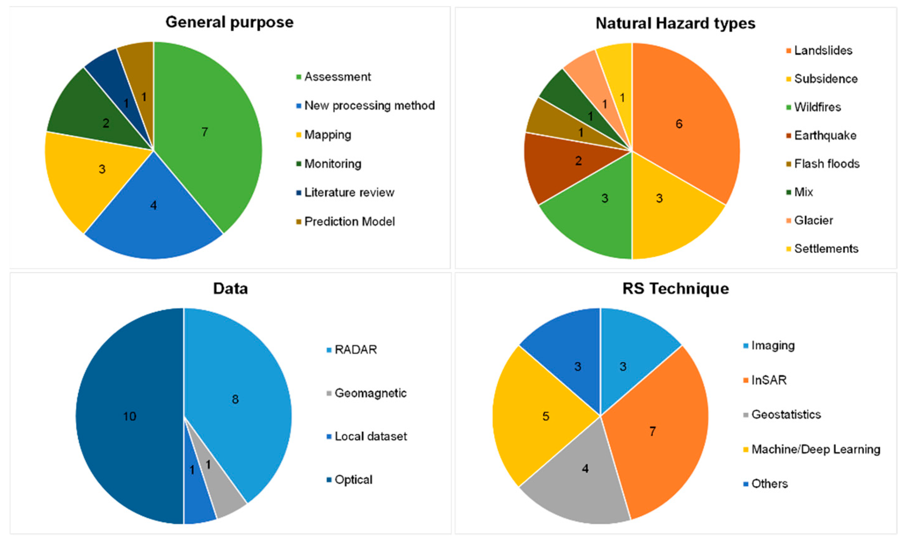
The 18 papers published in the current Special Issue belong to the section “Environmental Remote Sensing” and cover a wide range of applications in terms of the RS data exploited, processing techniques used, and NH addressed.
Chen et al. [1] applied multi-source remote sensing (InSAR from ALOS PALSAR-1 and -2) and field investigation to study the activity and kinematics of two adjacent landslides along the Datong River in the Qilian Mountains of the Qinghai-Tibet Plateau (China).
Wang et al. [2] proposed a data partition strategy to solve typical limitations due to traditional multi-temporal interferometric synthetic aperture radar (MT-InSAR) methods which require a large computer memory and time when processing full-resolution data. They validated such a strategy in Changzhou City and in Chongqing City (China).
Ma et al. [3] adopted a new open-source tool named MAT.TRIGRS(V1.0) to establish the landslide susceptibility map in landslide abundance areas and to back-analyze the response of the rainfall process to the change in landslide stability. The prediction results were roughly consistent with the actual landslide distributions in Longchuan County (China).
Wang et al. [4] proposed a wide-area InSAR variable-scale deformation detection strategy that combined stacking technology for fast ground-deformation rate calculations and advanced TS–InSAR technology to obtain a fine deformation time series. This new strategy was tested in the Turpan–Hami basin (China).
Xiong et al. [5] presented a new strategy based on the Multitemporal Interferometric Synthetic Aperture Radar (MT-InSAR) method to overcome limitations due to an inaccurate settlement prediction using traditional methods. The Xiamen Xiang’an International Airport (China) was chosen as the test site.
Wangcai et al. [6] assessed landslide susceptibility, hazard, and risk in Yan’an City (China) using a random forest machine learning classifier and eight environmental factors influencing landslides. Additionally, Differential Synthetic Aperture Radar Interferometry (DInSAR) was used for a hazard assessment.
Hermle et al. [7], with the aim of reducing noise from decorrelation in ground motion detection by imaging, applied, for the first time, the optical flow-time series for fast landslides. The debris flows from the Sattelkar area (Austria) was selected as a benchmark site.
Li et al. [8], in order to obtain a precise casualty prediction method that could be applied globally, a spatial division method based on regional differences and a zoning casualty prediction method based on support vector regression (SVR) were proposed in their paper. A selection of 30 historical earthquakes that occurred in China’s mainland was chosen.
Seydi et al. [9] presented a novel framework for burned area mapping based on the deep Siamese morphological neural network (DSMNN-Net) and heterogeneous datasets. Two case study areas in Australian forests were selected.
Nolde et al. [10] exploited the possibilities of a recent EO dataset published by the German Aerospace Center (DLR) by exemplarily analyzing fire severity trends on the Australian East coast for the past 20 years.
Kos et al. [11] used SAR offset tracking to reconstruct a unique record of ice surface velocities for a 3.2-year period for the Palcaraju glacier located above Laguna Palcacocha, Cordillera Blanca (Peru).
Ding et al. [12] carried out a review of the literature related to the application of RS and GIS in the study of flash floods. They analyzed more than 200 articles published in the last 20 years, performing keyword co-occurrence, time zone chart, keyword burst, and the literature co-citation analysis.
Cheng et al. [13] presented a detailed analysis to investigate the disaster conditions of the Brumadinho dam failure (Brasil) using satellite images. Their in-depth analysis revealed a hazard chain containing three stages, namely dam failure, mud-, and hyper-concentrated flow.
Pacheco et al. [14] used RS to detect, map, and monitor areas that were affected by forest fires in central Portugal. For this purpose, the study analyzed the performance of the k-nearest neighbor (kNN) and random forest (RF) classifiers.
Ranjgar et al. [15] assessed land subsidence susceptibility for Shahryar County (Iran) using the adaptive neuro-fuzzy inference system (ANFIS) machine learning algorithm. Additionally, they assessed if ensembles of ANFIS with two meta-heuristic algorithms could yield a better prediction performance.
Wang et al. [16] proposed a new approach using the relief–slope angle relationship to identify rockfall source areas controlled by rock mass strength. By using data from helicopter-based RS imagery, a 10m-DEM, and fieldwork, historical rockfalls in the Wolong study area of Tibet (China) were identified.
Yang et al. [17] developed a rapid and innovative approach to estimate post-fire hillslope erosion using weather radar, RS, Google Earth Engine (GEE), GIS, and the revised universal soil loss equation (RUSLE). They assessed the Sydney drinking water catchment area and the Warragamba Dam (Australia).
Lastly, Piersanti et al. [18] presented the first evidence, via observation and modeling, of changes in magnetospheric field line resonance (FLR) eigenfrequency, which was associated with the earthquake occurrence, and demonstrated a causal connection between seismic phenomena and space-based observables.
The Editors expect that these studies will lead to fruitful discussions and scientific progress, which should ultimately help to improve the overall quality and reliability of remote sensing as a now indispensable tool for approaching natural hazards.

1.2. Statistics

The total number of researchers and technologists who contributed to the papers was 104, with an average of 5.8 contributors per article. As shown in Figure 2, most of them worked in China, at least in terms of affiliation, followed by Germany, Italy, Australia, and Iran. Overall, Universities and Institutions from 16 different countries were involved in the present Special Issue. Most of the papers described work with practical applications tested around the world.
The most recurring words among the keywords chosen by the authors are shown in the word cloud in Figure 3. Among them, “InSAR” was selected six times, followed by “landslide” (4 times), “burned area”, “sentinel”, and “wildfires” with three occurrences.

1.3. Bibliometrics and Impact

The 18 papers were published in the current Special Issue, over 2 years, between November 2020 and October 2022. Each manuscript was assessed via rigorous peer-reviewing from two or more esteemed experts in their respective fields. Based on MDPI’s article metrics, this Special Issue has received, up to now (2 February 2023), more than 34,000 total views. A worldwide geographic distribution of readers was also noted. Overall, the published papers already received 95 citations in the indexed literature indicating the high scientific quality of the Special Issue. In detail, the work from Ranjgar et al. [15] reached 22 citations and 3299 online views, followed by the papers from Pacheco et al. [14] and Ding et al. [12] with 16 and 12 citations, respectively.

2. Further Reading

Readers who are interested in the use of remote sensing data and methods for the assessment and control of natural hazards, in addition to this Special Issue, can also refer to manuscripts published in other recent Special Issues of the Remote Sensing journal, such as the “Remote Sensing of Natural Hazards” issued in 2019–2020 (https://www.mdpi.com/si/32980 (accessed on 2 February 2023)), “Remote Sensing in Engineering Geology” published in 2020–2021 (https://www.mdpi.com/si/28775 (accessed on 2 February 2023)), and “Natural Hazard Assessment and Disaster Management Using Remote Sensing” available from 2021 (https://www.mdpi.com/si/64420 (accessed on 2 February 2023)). In these Issues, several applications are offered, ranging from GIS-based hazard assessment to the use of multi-sensor data for hazard detection and mapping. Even in these examples, a wide range of natural hazards is covered, including wildfires, earthquakes, landslides, and floods.

Author Contributions

The authors contributed equally to this work. All authors have read and agreed to the published version of the manuscript.

Acknowledgments

The Guest Editors would like to acknowledge all the authors for contributing to this Special Issue and all the involved reviewers for their thoughtful comments and efforts toward improving the submitted manuscripts. Sincere gratitude goes to the Editorial Board and Office of Remote Sensing.

Conflicts of Interest

The authors declare no conflict of interest.

References

  1. Chen, J.; Zhang, J.; Wu, T.; Hao, J.; Wu, X.; Ma, X.; Zhu, X.; Lou, P.; Zhang, L. Activity and Kinematics of Two Adjacent Freeze–Thaw-Related Landslides Revealed by Multisource Remote Sensing of Qilian Mountain. Remote Sens. 2022, 14, 5059. [Google Scholar] [CrossRef]
  2. Wang, Y.; Feng, G.; Feng, Z.; Wang, Y.; Wang, X.; Luo, S.; Zhao, Y.; Lu, H. An MT-InSAR Data Partition Strategy for Sentinel-1A/B TOPS Data. Remote Sens. 2022, 14, 4562. [Google Scholar] [CrossRef]
  3. Ma, S.; Shao, X.; Xu, C. Characterizing the Distribution Pattern and a Physically Based Susceptibility Assessment of Shallow Landslides Triggered by the 2019 Heavy Rainfall Event in Longchuan County, Guangdong Province, China. Remote Sens. 2022, 14, 4257. [Google Scholar] [CrossRef]
  4. Wang, Y.; Feng, G.; Li, Z.; Luo, S.; Wang, H.; Xiong, Z.; Zhu, J.; Hu, J. A Strategy for Variable-Scale InSAR Deformation Monitoring in a Wide Area: A Case Study in the Turpan–Hami Basin, China. Remote Sens. 2022, 14, 3832. [Google Scholar] [CrossRef]
  5. Xiong, Z.; Deng, K.; Feng, G.; Miao, L.; Li, K.; He, C.; He, Y. Settlement Prediction of Reclaimed Coastal Airports with InSAR Observation: A Case Study of the Xiamen Xiang’an International Airport, China. Remote Sens. 2022, 14, 3081. [Google Scholar] [CrossRef]
  6. Liu, W.; Zhang, Y.; Liang, Y.; Sun, P.; Li, Y.; Su, X.; Wang, A.; Meng, X. Landslide Risk Assessment Using a Combined Approach Based on InSAR and Random Forest. Remote Sens. 2022, 14, 2131. [Google Scholar] [CrossRef]
  7. Hermle, D.; Gaeta, M.; Krautblatter, M.; Mazzanti, P.; Keuschnig, M. Performance Testing of Optical Flow Time Series Analyses Based on a Fast, High-Alpine Landslide. Remote Sens. 2022, 14, 455. [Google Scholar] [CrossRef]
  8. Li, B.; Gong, A.; Zeng, T.; Bao, W.; Xu, C.; Huang, Z. A Zoning Earthquake Casualty Prediction Model Based on Machine Learning. Remote Sens. 2022, 14, 30. [Google Scholar] [CrossRef]
  9. Seydi, S.T.; Hasanlou, M.; Chanussot, J. DSMNN-Net: A Deep Siamese Morphological Neural Network Model for Burned Area Mapping Using Multispectral Sentinel-2 and Hyperspectral PRISMA Images. Remote Sens. 2021, 13, 5138. [Google Scholar] [CrossRef]
  10. Nolde, M.; Mueller, N.; Strunz, G.; Riedlinger, T. Assessment of Wildfire Activity Development Trends for Eastern Australia Using Multi-Sensor Earth Observation Data. Remote Sens. 2021, 13, 4975. [Google Scholar] [CrossRef]
  11. Kos, A.; Amann, F.; Strozzi, T.; Osten, J.; Wellmann, F.; Jalali, M.; Dufresne, A. The Surface Velocity Response of a Tropical Glacier to Intra and Inter Annual Forcing, Cordillera Blanca, Peru. Remote Sens. 2021, 13, 2694. [Google Scholar] [CrossRef]
  12. Ding, L.; Ma, L.; Li, L.; Liu, C.; Li, N.; Yang, Z.; Yao, Y.; Lu, H. A Survey of Remote Sensing and Geographic Information System Applications for Flash Floods. Remote Sens. 2021, 13, 1818. [Google Scholar] [CrossRef]
  13. Cheng, D.; Cui, Y.; Li, Z.; Iqbal, J. Watch Out for the Tailings Pond, a Sharp Edge Hanging over Our Heads: Lessons Learned and Perceptions from the Brumadinho Tailings Dam Failure Disaster. Remote Sens. 2021, 13, 1775. [Google Scholar] [CrossRef]
  14. Pacheco, A.d.P.; Junior, J.A.d.S.; Ruiz-Armenteros, A.M.; Henriques, R.F.F. Assessment of k-Nearest Neighbor and Random Forest Classifiers for Mapping Forest Fire Areas in Central Portugal Using Landsat-8, Sentinel-2, and Terra Imagery. Remote Sens. 2021, 13, 1345. [Google Scholar] [CrossRef]
  15. Ranjgar, B.; Razavi-Termeh, S.V.; Foroughnia, F.; Sadeghi-Niaraki, A.; Perissin, D. Land Subsidence Susceptibility Mapping Using Persistent Scatterer SAR Interferometry Technique and Optimized Hybrid Machine Learning Algorithms. Remote Sens. 2021, 13, 1326. [Google Scholar] [CrossRef]
  16. Wang, X.; Liu, H.; Sun, J. A New Approach for Identification of Potential Rockfall Source Areas Controlled by Rock Mass Strength at a Regional Scale. Remote Sens. 2021, 13, 938. [Google Scholar] [CrossRef]
  17. Yang, X.; Zhang, M.; Oliveira, L.; Ollivier, Q.R.; Faulkner, S.; Roff, A. Rapid Assessment of Hillslope Erosion Risk after the 2019–2020 Wildfires and Storm Events in Sydney Drinking Water Catchment. Remote Sens. 2020, 12, 3805. [Google Scholar] [CrossRef]
  18. Piersanti, M.; Burger, W.J.; Carbone, V.; Battiston, R.; Iuppa, R.; Ubertini, P. On the Geomagnetic Field Line Resonance Eigenfrequency Variations during Seismic Event. Remote Sens. 2021, 13, 2839. [Google Scholar] [CrossRef]
Figure 1. Pie charts of general purpose, natural hazard types, data, and RS technique of published papers.
Remotesensing 15 01048 g001
Figure 2. Overview of the authors’ affiliation by country together with the location of case studies discussed in the present Special Issue.
Remotesensing 15 01048 g002
Figure 3. Word clouds (also known as text clouds or tag clouds) generated from the keywords of all contributions to the present Special Issue. The more a word appears as a keyword, the bigger and bolder it appears in the word cloud.
Remotesensing 15 01048 g003
Table 1. Overview of RS data, techniques, purposes, and NH types that are presented in the papers comprising the SI. Access links to each paper are also provided together with DOI numbers.
Paper Reference and DOI with Access LinkRS DataProcessing
Technique
General PurposeNatural Hazard Types
Chen et al. [1]
https://doi.org/10.3390/rs14195059 (accessed on 6 February 2023)
optical, radarInSARassessmentlandslide
Wang et al. [2]
https://doi.org/10.3390/rs14184562 (accessed on 6 February 2023)
radarInSARnew processing methodsubsidence
Ma et al. [3]
https://doi.org/10.3390/rs14174257 (accessed on 6 February 2023)
optical, radarInSAR,
TRIGRS model
mappinglandslide
Wang et al. [4]
https://doi.org/10.3390/rs14153832 (accessed on 6 February 2023)
radarInSARnew processing methodsubsidence
Xiong et al. [5]
https://doi.org/10.3390/rs14133081 (accessed on 6 February 2023)
radarInSAR,
exponential model
new processing methodsettlements
Wangcai et al. [6]
https://doi.org/10.3390/rs14092131 (accessed on 6 February 2023)
radarInSAR,
random forest
assessmentlandslide
Hermle et al. [7]
https://doi.org/10.3390/rs14030455 (accessed on 6 February 2023)
opticalImaging (CD, DIC)monitoringlandslide
Li et al. [8]
https://doi.org/10.3390/rs14010030 (accessed on 6 February 2023)
local datasetMachine learningprediction modelearthquake
Seydi et al. [9]
https://doi.org/10.3390/rs13245138 (accessed on 6 February 2023)
multispectral and hyperspectralDeep Learningmappingwildfires
Nolde et al. [10]
https://doi.org/10.3390/rs13244975 (accessed on 6 February 2023)
optical
(red and NIR)
Imaging (NDVI)assessmentwildfires
Kos et al. [11]
https://doi.org/10.3390/rs13142694 (accessed on 6 February 2023)
optical, radarSAR offset trackingmonitoringglacier
Ding et al. [12]
https://doi.org/10.3390/rs13091818 (accessed on 6 February 2023)
review of the literatureflash floods
Cheng et al. [13]
https://doi.org/10.3390/rs13091775 (accessed on 6 February 2023)
opticalImaging (NDWI, SI)assessmenthazard chain
(dam failure, mud and hyperc. flow)
Pacheco et al. [14]
https://doi.org/10.3390/rs13071345 (accessed on 6 February 2023)
multispectralk-Nearest neighbor, random forestassessmentwildfires
Ranjgar et al. [15]
https://doi.org/10.3390/rs13071326 (accessed on 6 February 2023)
radarInSAR,
Machine Learning
mappingsubsidence
Wang et al. [16]
https://doi.org/10.3390/rs13050938 (accessed on 6 February 2023)
opticalGeostatisticsassessmentrockfall
Yang et al. [17]
https://doi.org/10.3390/rs12223805 (accessed on 6 February 2023)
multispectralGeostatistics, RUSLE, NBRnew processing methodhillslope erosion
Piersanti et al. [18]
https://doi.org/10.3390/rs13142839 (accessed on 6 February 2023)
geomagneticGeostatisticsassessmentearthquake
Disclaimer/Publisher’s Note: The statements, opinions and data contained in all publications are solely those of the individual author(s) and contributor(s) and not of MDPI and/or the editor(s). MDPI and/or the editor(s) disclaim responsibility for any injury to people or property resulting from any ideas, methods, instructions or products referred to in the content.

