Introduction to a Thematic Set of Papers on Remote Sensing for Natural Hazards Assessment and Control
Abstract
:1. Overview of the Special Issue
1.1. Overview of the Presented Papers
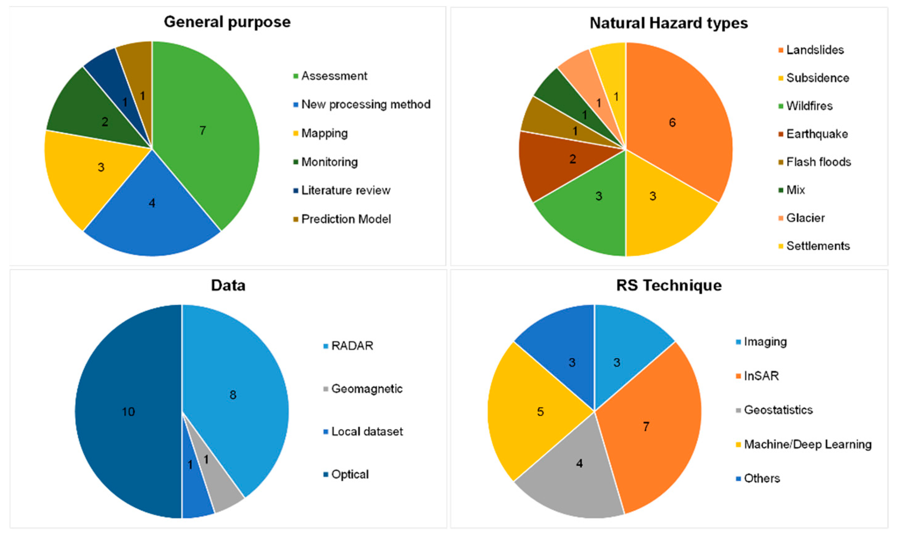
1.2. Statistics
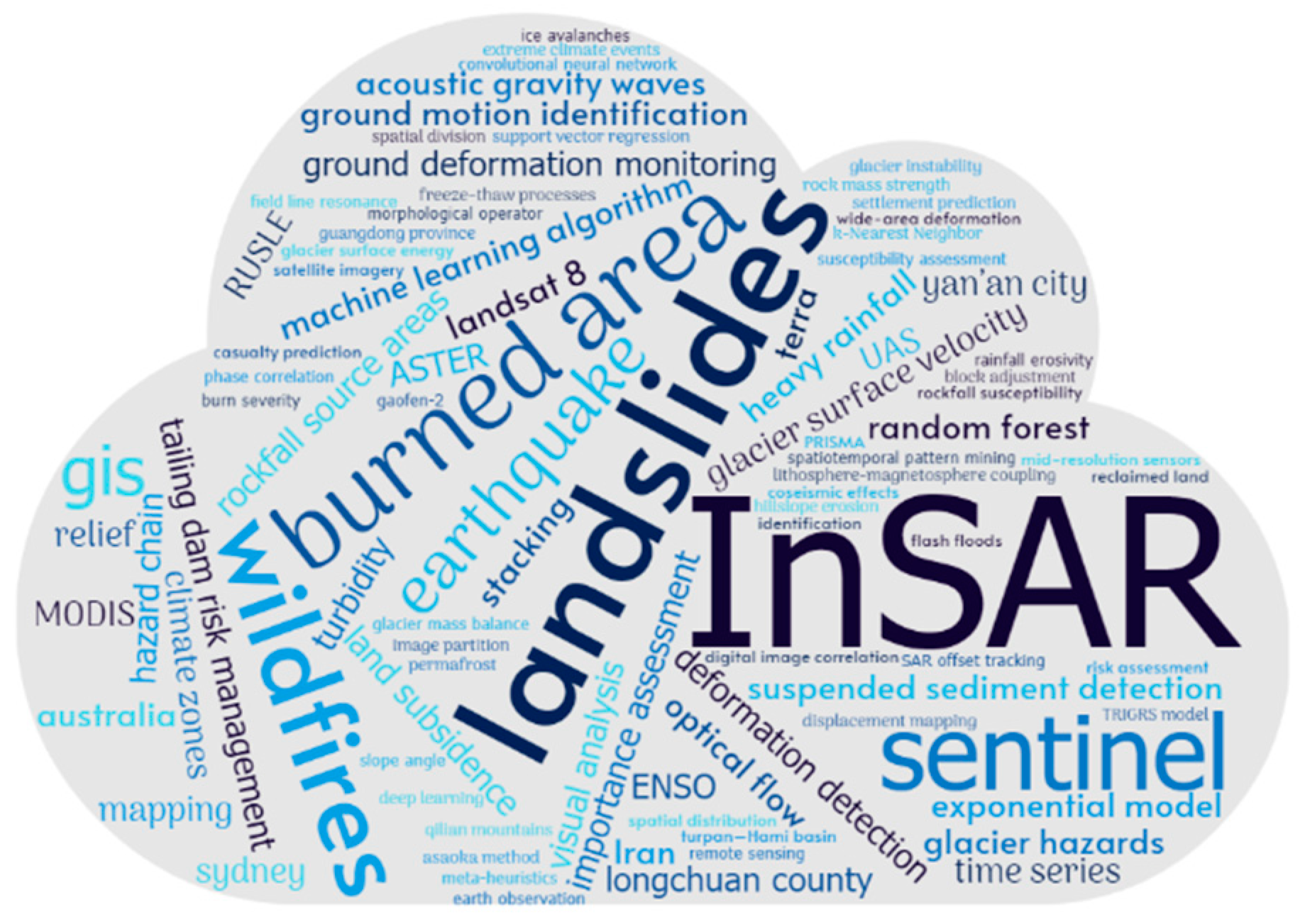
1.3. Bibliometrics and Impact
2. Further Reading
Author Contributions
Acknowledgments
Conflicts of Interest
References
- Chen, J.; Zhang, J.; Wu, T.; Hao, J.; Wu, X.; Ma, X.; Zhu, X.; Lou, P.; Zhang, L. Activity and Kinematics of Two Adjacent Freeze–Thaw-Related Landslides Revealed by Multisource Remote Sensing of Qilian Mountain. Remote Sens. 2022, 14, 5059. [Google Scholar] [CrossRef]
- Wang, Y.; Feng, G.; Feng, Z.; Wang, Y.; Wang, X.; Luo, S.; Zhao, Y.; Lu, H. An MT-InSAR Data Partition Strategy for Sentinel-1A/B TOPS Data. Remote Sens. 2022, 14, 4562. [Google Scholar] [CrossRef]
- Ma, S.; Shao, X.; Xu, C. Characterizing the Distribution Pattern and a Physically Based Susceptibility Assessment of Shallow Landslides Triggered by the 2019 Heavy Rainfall Event in Longchuan County, Guangdong Province, China. Remote Sens. 2022, 14, 4257. [Google Scholar] [CrossRef]
- Wang, Y.; Feng, G.; Li, Z.; Luo, S.; Wang, H.; Xiong, Z.; Zhu, J.; Hu, J. A Strategy for Variable-Scale InSAR Deformation Monitoring in a Wide Area: A Case Study in the Turpan–Hami Basin, China. Remote Sens. 2022, 14, 3832. [Google Scholar] [CrossRef]
- Xiong, Z.; Deng, K.; Feng, G.; Miao, L.; Li, K.; He, C.; He, Y. Settlement Prediction of Reclaimed Coastal Airports with InSAR Observation: A Case Study of the Xiamen Xiang’an International Airport, China. Remote Sens. 2022, 14, 3081. [Google Scholar] [CrossRef]
- Liu, W.; Zhang, Y.; Liang, Y.; Sun, P.; Li, Y.; Su, X.; Wang, A.; Meng, X. Landslide Risk Assessment Using a Combined Approach Based on InSAR and Random Forest. Remote Sens. 2022, 14, 2131. [Google Scholar] [CrossRef]
- Hermle, D.; Gaeta, M.; Krautblatter, M.; Mazzanti, P.; Keuschnig, M. Performance Testing of Optical Flow Time Series Analyses Based on a Fast, High-Alpine Landslide. Remote Sens. 2022, 14, 455. [Google Scholar] [CrossRef]
- Li, B.; Gong, A.; Zeng, T.; Bao, W.; Xu, C.; Huang, Z. A Zoning Earthquake Casualty Prediction Model Based on Machine Learning. Remote Sens. 2022, 14, 30. [Google Scholar] [CrossRef]
- Seydi, S.T.; Hasanlou, M.; Chanussot, J. DSMNN-Net: A Deep Siamese Morphological Neural Network Model for Burned Area Mapping Using Multispectral Sentinel-2 and Hyperspectral PRISMA Images. Remote Sens. 2021, 13, 5138. [Google Scholar] [CrossRef]
- Nolde, M.; Mueller, N.; Strunz, G.; Riedlinger, T. Assessment of Wildfire Activity Development Trends for Eastern Australia Using Multi-Sensor Earth Observation Data. Remote Sens. 2021, 13, 4975. [Google Scholar] [CrossRef]
- Kos, A.; Amann, F.; Strozzi, T.; Osten, J.; Wellmann, F.; Jalali, M.; Dufresne, A. The Surface Velocity Response of a Tropical Glacier to Intra and Inter Annual Forcing, Cordillera Blanca, Peru. Remote Sens. 2021, 13, 2694. [Google Scholar] [CrossRef]
- Ding, L.; Ma, L.; Li, L.; Liu, C.; Li, N.; Yang, Z.; Yao, Y.; Lu, H. A Survey of Remote Sensing and Geographic Information System Applications for Flash Floods. Remote Sens. 2021, 13, 1818. [Google Scholar] [CrossRef]
- Cheng, D.; Cui, Y.; Li, Z.; Iqbal, J. Watch Out for the Tailings Pond, a Sharp Edge Hanging over Our Heads: Lessons Learned and Perceptions from the Brumadinho Tailings Dam Failure Disaster. Remote Sens. 2021, 13, 1775. [Google Scholar] [CrossRef]
- Pacheco, A.d.P.; Junior, J.A.d.S.; Ruiz-Armenteros, A.M.; Henriques, R.F.F. Assessment of k-Nearest Neighbor and Random Forest Classifiers for Mapping Forest Fire Areas in Central Portugal Using Landsat-8, Sentinel-2, and Terra Imagery. Remote Sens. 2021, 13, 1345. [Google Scholar] [CrossRef]
- Ranjgar, B.; Razavi-Termeh, S.V.; Foroughnia, F.; Sadeghi-Niaraki, A.; Perissin, D. Land Subsidence Susceptibility Mapping Using Persistent Scatterer SAR Interferometry Technique and Optimized Hybrid Machine Learning Algorithms. Remote Sens. 2021, 13, 1326. [Google Scholar] [CrossRef]
- Wang, X.; Liu, H.; Sun, J. A New Approach for Identification of Potential Rockfall Source Areas Controlled by Rock Mass Strength at a Regional Scale. Remote Sens. 2021, 13, 938. [Google Scholar] [CrossRef]
- Yang, X.; Zhang, M.; Oliveira, L.; Ollivier, Q.R.; Faulkner, S.; Roff, A. Rapid Assessment of Hillslope Erosion Risk after the 2019–2020 Wildfires and Storm Events in Sydney Drinking Water Catchment. Remote Sens. 2020, 12, 3805. [Google Scholar] [CrossRef]
- Piersanti, M.; Burger, W.J.; Carbone, V.; Battiston, R.; Iuppa, R.; Ubertini, P. On the Geomagnetic Field Line Resonance Eigenfrequency Variations during Seismic Event. Remote Sens. 2021, 13, 2839. [Google Scholar] [CrossRef]


| Paper Reference and DOI with Access Link | RS Data | Processing Technique | General Purpose | Natural Hazard Types |
|---|---|---|---|---|
| Chen et al. [1] https://doi.org/10.3390/rs14195059 (accessed on 6 February 2023) | optical, radar | InSAR | assessment | landslide |
| Wang et al. [2] https://doi.org/10.3390/rs14184562 (accessed on 6 February 2023) | radar | InSAR | new processing method | subsidence |
| Ma et al. [3] https://doi.org/10.3390/rs14174257 (accessed on 6 February 2023) | optical, radar | InSAR, TRIGRS model | mapping | landslide |
| Wang et al. [4] https://doi.org/10.3390/rs14153832 (accessed on 6 February 2023) | radar | InSAR | new processing method | subsidence |
| Xiong et al. [5] https://doi.org/10.3390/rs14133081 (accessed on 6 February 2023) | radar | InSAR, exponential model | new processing method | settlements |
| Wangcai et al. [6] https://doi.org/10.3390/rs14092131 (accessed on 6 February 2023) | radar | InSAR, random forest | assessment | landslide |
| Hermle et al. [7] https://doi.org/10.3390/rs14030455 (accessed on 6 February 2023) | optical | Imaging (CD, DIC) | monitoring | landslide |
| Li et al. [8] https://doi.org/10.3390/rs14010030 (accessed on 6 February 2023) | local dataset | Machine learning | prediction model | earthquake |
| Seydi et al. [9] https://doi.org/10.3390/rs13245138 (accessed on 6 February 2023) | multispectral and hyperspectral | Deep Learning | mapping | wildfires |
| Nolde et al. [10] https://doi.org/10.3390/rs13244975 (accessed on 6 February 2023) | optical (red and NIR) | Imaging (NDVI) | assessment | wildfires |
| Kos et al. [11] https://doi.org/10.3390/rs13142694 (accessed on 6 February 2023) | optical, radar | SAR offset tracking | monitoring | glacier |
| Ding et al. [12] https://doi.org/10.3390/rs13091818 (accessed on 6 February 2023) | review of the literature | flash floods | ||
| Cheng et al. [13] https://doi.org/10.3390/rs13091775 (accessed on 6 February 2023) | optical | Imaging (NDWI, SI) | assessment | hazard chain (dam failure, mud and hyperc. flow) |
| Pacheco et al. [14] https://doi.org/10.3390/rs13071345 (accessed on 6 February 2023) | multispectral | k-Nearest neighbor, random forest | assessment | wildfires |
| Ranjgar et al. [15] https://doi.org/10.3390/rs13071326 (accessed on 6 February 2023) | radar | InSAR, Machine Learning | mapping | subsidence |
| Wang et al. [16] https://doi.org/10.3390/rs13050938 (accessed on 6 February 2023) | optical | Geostatistics | assessment | rockfall |
| Yang et al. [17] https://doi.org/10.3390/rs12223805 (accessed on 6 February 2023) | multispectral | Geostatistics, RUSLE, NBR | new processing method | hillslope erosion |
| Piersanti et al. [18] https://doi.org/10.3390/rs13142839 (accessed on 6 February 2023) | geomagnetic | Geostatistics | assessment | earthquake |
Disclaimer/Publisher’s Note: The statements, opinions and data contained in all publications are solely those of the individual author(s) and contributor(s) and not of MDPI and/or the editor(s). MDPI and/or the editor(s) disclaim responsibility for any injury to people or property resulting from any ideas, methods, instructions or products referred to in the content. |
© 2023 by the authors. Licensee MDPI, Basel, Switzerland. This article is an open access article distributed under the terms and conditions of the Creative Commons Attribution (CC BY) license (https://creativecommons.org/licenses/by/4.0/).
Share and Cite
Mazzanti, P.; Romeo, S. Introduction to a Thematic Set of Papers on Remote Sensing for Natural Hazards Assessment and Control. Remote Sens. 2023, 15, 1048. https://doi.org/10.3390/rs15041048
Mazzanti P, Romeo S. Introduction to a Thematic Set of Papers on Remote Sensing for Natural Hazards Assessment and Control. Remote Sensing. 2023; 15(4):1048. https://doi.org/10.3390/rs15041048
Chicago/Turabian StyleMazzanti, Paolo, and Saverio Romeo. 2023. "Introduction to a Thematic Set of Papers on Remote Sensing for Natural Hazards Assessment and Control" Remote Sensing 15, no. 4: 1048. https://doi.org/10.3390/rs15041048
APA StyleMazzanti, P., & Romeo, S. (2023). Introduction to a Thematic Set of Papers on Remote Sensing for Natural Hazards Assessment and Control. Remote Sensing, 15(4), 1048. https://doi.org/10.3390/rs15041048


