Identifying Spatial Variation of Carbon Stock in a Warm Temperate Forest in Central Japan Using Sentinel-2 and Digital Elevation Model Data
Abstract
:1. Introduction
2. Materials and Methods
2.1. Study Area
2.2. Field Inventory Data
2.3. RS Data
2.3.1. Data
2.3.2. Data Pre-Processing
2.3.3. Ancillary Variables
2.4. Data Analysis
2.4.1. Feature Selection
2.4.2. Carbon Stock Prediction by Machine Leaning
2.4.3. Carbon Stock Mapping by Forest Type and Stand Age
2.4.4. Factors Driving the Spatial Distribution of Carbon Stock
3. Results
3.1. RS Dataset and Regression Modeling for Carbon Stock
3.2. Mapping of Forest Carbon Stock over the Study Area
3.3. Calculation of Mapped CST by Forest Type and Stand Age
3.4. Relative Importance of Factors Driving the Spatial Distribution of Carbon Stock
4. Discussion
4.1. Model Performance for Forest Carbon Stock
4.2. Mapping of CST
4.3. Calculation of CST Maps by Forest Type and Stand Age
4.4. Relative Importance of Factors Driving the Spatial Distribution of Carbon Stock
5. Conclusions
Author Contributions
Funding
Data Availability Statement
Acknowledgments
Conflicts of Interest
Appendix A

| BEF>20 [-] | R [-] | D [t-d.m./m3] | CF [t-C./t-d.m] | Note | ||
|---|---|---|---|---|---|---|
| Conifer trees | Japanese cedar | 1.23 | 0.25 | 0.314 | 0.51 | |
| Hinoki cypress | 1.24 | 0.26 | 0.407 | |||
| Sawara cypress | 1.24 | 0.26 | 0.287 | |||
| Japanese red pine | 1.23 | 0.26 | 0.451 | |||
| Japanese black pine | 1.36 | 0.34 | 0.464 | |||
| Hiba arborvitae | 1.41 | 0.20 | 0.412 | |||
| Japanese larch | 1.15 | 0.29 | 0.404 | |||
| Momi fir | 1.40 | 0.40 | 0.423 | |||
| Sakahaline fir | 1.38 | 0.21 | 0.318 | |||
| Japanese hemlock | 1.40 | 0.40 | 0.464 | |||
| Yezo spruce | 1.48 | 0.23 | 0.357 | |||
| Sakhaline spruce | 1.67 | 0.21 | 0.362 | |||
| Japanese umbrella pine | 1.23 | 0.20 | 0.455 | |||
| Japanese yew | 1.23 | 0.20 | 0.454 | |||
| Ginkgo | 1.15 | 0.20 | 0.450 | |||
| Exotic conifer trees | 1.41 | 0.17 | 0.320 | |||
| Other conifer trees | 1.32 | 0.34 | 0.352 | Applied to Hokkaido, Aomori, Iwate, Miyagi, Akita, Yamagata, Fukushima, Tochigi, Gunma, Saitama, Niigata, Toyama, Yamanashi, Nagano, Gifu and Shizuoka prefectures | ||
| 1.36 | 0.34 | 0.464 | Applied to Okinawa prefecture | |||
| 1.40 | 1.40 | 0.423 | Applied to prefectures other than above | |||
| Broad leaf tree | Japanese beech | 1.32 | 0.26 | 0.573 | 0.48 | |
| Oak (evergreen tree) | 1.33 | 0.26 | 0.646 | |||
| Japanese chestnut | 1.18 | 0.26 | 0.419 | |||
| Japanese chestnut oak | 1.32 | 0.26 | 0.668 | |||
| Oak (deciduous tree) | 1.26 | 0.26 | 0.624 | |||
| Japanese popular | 1.18 | 0.26 | 0.291 | |||
| Alder | 1.25 | 0.26 | 0.454 | |||
| Japanese elm | 1.18 | 0.26 | 0.494 | |||
| Japanese zelkova | 1.28 | 0.26 | 0.611 | |||
| Cercidiphyllum | 1.18 | 0.26 | 0.454 | |||
| Japanese big-leaf | 1.18 | 0.26 | 0.386 | |||
| Maple tree | 1.18 | 0.26 | 0.519 | |||
| Amur cork | 1.18 | 0.26 | 0.344 | |||
| Linden | 1.18 | 0.26 | 0.369 | |||
| Kalopanax | 1.18 | 0.26 | 0.398 | |||
| Paulownia | 1.18 | 0.26 | 0.234 | |||
| Exotic broad leaf trees | 1.41 | 0.16 | 0.660 | |||
| Japanese birch | 1.20 | 0.26 | 0.468 | |||
| Other broad leaf trees | 1.37 | 0.26 | 0.469 | Applied to Chiba, Tokyo, Kochi, Fukuoka, Nagasaki, Kagoshima, and Okinawa prefectures | ||
| 1.33 | 0.26 | 0.646 | Applied to Mie, Wakayama, Oita, Kumamoto, Miyazaki, and Saga prefectures | |||
| 1.26 | 0.26 | 0.624 | Applied to prefectures other than above | |||
| CST (Mg C ha−1) | S2 (Mg C) | S2_Topo (Mg C) | S2_Topo_VI (Mg C) | S2_Topo_VI_Texture (Mg C) | Conv (Mg C) |
|---|---|---|---|---|---|
| PL <150 | 432,676 | 504,370 | 504,886 | 513,535 | 1,374,287 |
| PL 150–250 | 8,164,040 | 8,373,485 | 8,301,671 | 8,860,915 | 7,789,185 |
| PL 250–350 | 7,363,467 | 7,376,410 | 7,446,232 | 6,831,954 | 5,734,396 |
| PL >350 | 320,299 | 108,915 | 128,206 | 91,733 | 179,358 |
| NA <150 | 3,446,337 | 3,985,776 | 3,958,532 | 3,990,232 | - |
| NA 150–250 | 17,104,830 | 19,090,126 | 19,056,023 | 19,552,259 | 18,551,958 |
| NA 250–350 | 7,441,847 | 5,300,974 | 5,378,746 | 4,991,938 | 12,865,968 |
| NA >350 | 103,647 | 35,920 | 43,115 | 8809 | - |
| Total_PL | 16,280,482 | 16,363,180 | 16,380,995 | 16,298,137 | 15,077,226 |
| Total_NA | 28,096,661 | 28,412,796 | 28,436,416 | 28,543,238 | 31,417,926 |
| Total | 44,377,143 | 44,775,976 | 44,817,411 | 44,841,375 | 46,495,152 |
| Stand Age (Years Old) | S2 (Mg C ha−1) | S2_Topo (Mg C ha−1) | S2_Topo_VI (Mg C ha−1) | S2_Topo_VI_Texture (Mg C ha−1) | Conv (Mg C ha−1) | |||||
|---|---|---|---|---|---|---|---|---|---|---|
| NA | PL | NA | PL | NA | PL | NA | PL | NA | PL | |
| <30 | NO | 220.53 (44.33) | NO | 221.84 (37.20) | NO | 221.75 (37.78) | NO | 218.43 (34.15) | NO | 63.89 (38.11) |
| 30–49 | NO | 239.48 (34.34) | NO | 242.38 (30.81) | NO | 242.74 (31.03) | NO | 239.41 (28.05) | NO | 122.61 (21.61) |
| 50–69 | 195.07 (45.77) | 241.96 (34.92) | 198.21 (37.78) | 241.73 (29.74) | 198.45 (38.13) | 242.13 (29.90) | 199.83 (35.37) | 239.49 (31.76) | 191.61 (58.17) | 214.56 (21.23) |
| 70–89 | 199.11 (47.71) | 235.42 (32.87) | 201.91 (39.68) | 234.36 (27.59) | 202.08 (40.19) | 234.59 (27.79) | 202.23 (37.10) | 234.19 (31.76) | 275.77 (75.51) | 279.12 (65.74) |
| 90–109 | 221.6 (39.36) | 237.98 (34.15) | 219.26 (32.22) | 238.92 (29.01) | 219.15 (32.48) | 239.23 (29.36) | 219.96 (29.78) | 239.46 (28.25) | 207.46 (44.07) | 234.66 (61.59) |
| 110–129 | 214.74 (40.25) | 243.02 (38.61) | 219.28 (33.47) | 246.31 (33.41) | 219.48 (33.75) | 246.38 (33.80) | 218.67 (30.23) | 246.74 (30.64) | 210.72 (38.21) | 269.17 (57.64) |
| 130–200 | 257.86 (45.41) | 268.32 (42.69) | 258.45 (41.46) | 273.19 (30.81) | 259.13 (41.92) | 273.82 (31.50) | 252.32 (34.35) | 271.36 (33.39) | 256.61 (72.53) | 537.36 |
References
- Harris, N.L.; Gibbs, D.A.; Baccini, A.; Birdsey, R.A.; de Bruin, S.; Farina, M.; Fatoyinbo, L.; Hansen, M.C.; Herold, M.; Houghton, R.A.; et al. Global maps of twenty-first century forest carbon fluxes. Nat. Clim. Chang. 2021, 11, 234–240. [Google Scholar] [CrossRef]
- O’Sullivan, M.; Friedlingstein, P.; Sitch, S.; Anthoni, P.; Arneth, A.; Arora, V.K.; Bastrikov, V.; Delire, C.; Goll, D.S.; Jain, A.; et al. Process-oriented analysis of dominant sources of uncertainty in the land carbon sink. Nat. Commun. 2022, 13, 4781. [Google Scholar] [CrossRef] [PubMed]
- Egusa, T.; Kumagai, T.; Shiraishi, N. Carbon stock in Japanese forests has been greatly underestimated. Sci. Rep. 2020, 10, 7895. [Google Scholar] [CrossRef] [PubMed]
- Rozendaal, D.M.A.; Requena Suarez, D.; De Sy, V.; Avitabile, V.; Carter, S.; Adou Yao, C.Y.; Alvarez-Davila, E.; Anderson-Teixeira, K.; Araujo-Murakami, A.; Arroyo, L.; et al. Aboveground forest biomass varies across continents, ecological zones and successional stages: Refined IPCC default values for tropical and subtropical forests. Environ. Res. Lett. 2022, 17, 014047. [Google Scholar] [CrossRef]
- Fang, J.; Oikawa, T.; Kato, T.; Mo, W.; Wang, Z. Biomass carbon accumulation by Japan’s forest from 1947 to 1995. Global Biogeochem. Cycles 2005, 19, GB2004. [Google Scholar] [CrossRef]
- Baccini, A.; Walker, W.; Carvalho, L.; Farina, M.; Houghton, R.A. Tropical forests are a net carbon source based on aboveground measurements of gain and loss. Science 2019, 363, 230–234. [Google Scholar] [CrossRef] [PubMed] [Green Version]
- Pandey, S.S.; Maraseni, T.N.; Cockfield, G. Carbon stock dynamics in different vegetation dominated community forests under REDD+: A case from Nepal. For. Ecol. Manag. 2014, 327, 40–47. [Google Scholar] [CrossRef]
- Orians, G.H.; Millar, C.I. IPCC 2006 IPCC Guidelines for National Greenhouse Gas Inventories: Agriculture, Forestry and Other Land Use vol 4. Agric. Ecosyst. Environ. 2006, 4. Available online: https://www.ipcc-nggip.iges.or.jp/public/2006gl/vol4.html (accessed on 19 February 2021).
- Domke, G.; Brandon, A.; Diaz-Lasco, R.D.-L.; Federici, S.; Garcia-Apaza, E.; Grassi, G.; Gschwantner, T.; Herold, M.; Hirata, Y.; Kasimir, Å.; et al. IPCC 2019 Refinement to the 2006 IPCC Guidelines for National Greenhouse Gas Inventories: Agriculture, Forestry and Other Land Use. Refinement 2006 IPCC Guidel. Natl. Greenh. Gas Invent. 2019, 4, 194. [Google Scholar]
- Walliker, D.; Collins, W.E.; Jeffery, G.M.; Dietz, K.; Raddatz, G.; Molineaux, L.; Matthews, L.; Timms, R.; Colegrave, N.; Grenfell, B.T.; et al. A Large and Persistent Carbon Sink in the World’s Forests. Science 2011, 333, 988–993. [Google Scholar] [CrossRef] [Green Version]
- Ren, H.; Chen, H.; Li, L.; Li, P.; Hou, C.; Wan, H.; Zhang, Q.; Zhang, P. Spatial and temporal patterns of carbon storage from 1992 to 2002 in forest ecosystems in Guangdong, Southern China. Plant Soil 2013, 363, 123–138. [Google Scholar] [CrossRef]
- Chen, L.C.; Guan, X.; Li, H.M.; Wang, Q.K.; Zhang, W.D.; Yang, Q.P.; Wang, S.L. Spatiotemporal patterns of carbon storage in forest ecosystems in Hunan Province, China. For. Ecol. Manag. 2019, 432, 656–666. [Google Scholar] [CrossRef]
- Zhao, M.; Yang, J.; Zhao, N.; Liu, Y.; Wang, Y.; Wilson, J.P.; Yue, T. Estimation of China’s forest stand biomass carbon sequestration based on the continuous biomass expansion factor model and seven forest inventories from 1977 to 2013. For. Ecol. Manag. 2019, 448, 528–534. [Google Scholar] [CrossRef]
- Thurner, M.; Beer, C.; Santoro, M.; Carvalhais, N.; Wutzler, T.; Schepaschenko, D.; Shvidenko, A.; Kompter, E.; Ahrens, B.; Levick, S.R.; et al. Carbon stock and density of northern boreal and temperate forests. Glob. Ecol. Biogeogr. 2014, 23, 297–310. [Google Scholar] [CrossRef] [Green Version]
- Fang, J.; Guo, Z.; Hu, H.; Kato, T.; Muraoka, H.; Son, Y. Forest biomass carbon sinks in East Asia, with special reference to the relative contributions of forest expansion and forest growth. Glob. Chang. Biol. 2014, 20, 2019–2030. [Google Scholar] [CrossRef]
- Li, X.; Farooqi, T.J.A.; Jiang, C.; Liu, S.; Sun, O.J. Spatiotemporal variations in productivity and water use efficiency across a temperate forest landscape of Northeast China. For. Ecosyst. 2019, 6, 22. [Google Scholar] [CrossRef] [Green Version]
- Côté, L.; Brown, S.; Paré, D.; Fyles, J.; Bauhus, J. Dynamics of carbon and nitrogen mineralization in relation to stand type, stand age and soil texture in the boreal mixedwood. Soil Biol. Biochem. 2000, 32, 1079–1090. [Google Scholar] [CrossRef]
- Helmer, E.H.; Brandeis, T.J.; Lugo, A.E.; Kennaway, T. Factors influencing spatial pattern in tropical forest clearance and stand age: Implications for carbon storage and species diversity. J. Geophys. Res. Biogeosci. 2008, 113, G02S04. [Google Scholar] [CrossRef] [Green Version]
- Yu, Z.; Zhou, G.; Liu, S.; Sun, P.; Agathokleous, E. Impacts of forest management intensity on carbon accumulation of China’s forest plantations. For. Ecol. Manag. 2020, 472, 118252. [Google Scholar] [CrossRef]
- Ge, R.; He, H.; Ren, X.; Zhang, L.; Yu, G.; Smallman, T.L. Underestimated ecosystem carbon turnover time and sequestration under the steady state assumption: A perspective from long-term data assimilation. Glob. Chang. Biol. 2019, 25, 938–953. [Google Scholar] [CrossRef] [Green Version]
- Wai, P.; Su, H.; Li, M. Estimating Aboveground Biomass of Two Different Forest Types in Myanmar from Sentinel-2 Data with Machine Learning and Geostatistical Algorithms. Remote Sens. 2022, 14, 2146. [Google Scholar] [CrossRef]
- Baloloy, A.B.; Blanco, A.C.; Candido, C.G.; Argamosa, R.J.L.; Dumalag, J.B.L.C.; Dimapilis, L.L.C.; Paringit, E.C. Estimation of mangrove forest aboveground biomass using multispectral bands, vegetation indices, and biophysical variables derived from opical satellite imageries:Rapideye, Planet Scope and Sentinel-2. ISPRS Ann. Photogramm. Remote Sens. Spat. Inf. Sci. 2018, 4, 29–36. [Google Scholar] [CrossRef] [Green Version]
- Bhatti, S.; Ahmad, S.R.; Asif, M.; Farooqi, I.U.H. Estimation of aboveground carbon stock using Sentinel-2A data and Random Forest algorithm in scrub forests of the Salt Range, Pakistan. For. An Int. J. For. Res. 2023, 96, 104–120. [Google Scholar] [CrossRef]
- David, R.M.; Rosser, N.J.; Donoghue, D.N.M. Improving above ground biomass estimates of Southern Africa dryland forests by combining Sentinel-1 SAR and Sentinel-2 multispectral imagery. Remote Sens. Environ. 2022, 282, 113232. [Google Scholar] [CrossRef]
- Li, X.; Long, J.; Zhang, M.; Liu, Z.; Lin, H. Coniferous plantations growing stock volume estimation using advanced remote sensing algorithms and various fused data. Remote Sens. 2021, 13, 3468. [Google Scholar] [CrossRef]
- Sinha, S.; Mohan, S.; Das, A.K.; Sharma, L.K.; Jeganathan, C.; Santra, A.; Santra Mitra, S.; Nathawat, M.S. Multi-sensor approach integrating optical and multi-frequency synthetic aperture radar for carbon stock estimation over a tropical deciduous forest in India. Carbon Manag. 2020, 11, 39–55. [Google Scholar] [CrossRef]
- Wang, D.; Morton, D.; Masek, J.; Wu, A.; Nagol, J.; Xiong, X.; Levy, R.; Vermote, E.; Wolfe, R. Impact of sensor degradation on the MODIS NDVI time series. Remote Sens. Environ. 2012, 119, 55–161. [Google Scholar] [CrossRef]
- Wilson, B.T.; Woodall, C.W.; Griffith, D.M. Imputing forest carbon stock estimates from inventory plots to a nationally continuous coverage. Carbon Balance Manag. 2013, 8, 1–15. [Google Scholar] [CrossRef]
- Shafizadeh-Moghadam, H.; Minaei, F.; Talebi-khiyavi, H.; Xu, T.; Homaee, M. Synergetic use of multi-temporal Sentinel-1, Sentinel-2, NDVI, and topographic factors for estimating soil organic carbon. Catena 2022, 212, 106077. [Google Scholar] [CrossRef]
- Forkuor, G.; Benewinde Zoungrana, J.B.; Dimobe, K.; Ouattara, B.; Vadrevu, K.P.; Tondoh, J.E. Above-ground biomass mapping in West African dryland forest using Sentinel-1 and 2 datasets - A case study. Remote Sens. Environ. 2020, 236, 111496. [Google Scholar] [CrossRef]
- Nandy, S.; Srinet, R.; Padalia, H. Mapping Forest Height and Aboveground Biomass by Integrating ICESat-2, Sentinel-1 and Sentinel-2 Data Using Random Forest Algorithm in Northwest Himalayan Foothills of India. Geophys. Res. Lett. 2021, 48, 1–10. [Google Scholar] [CrossRef]
- Jayathunga, S.; Owari, T.; Tsuyuki, S. The use of fixed–wing UAV photogrammetry with LiDAR DTM to estimate merchantable volume and carbon stock in living biomass over a mixed conifer–broadleaf forest. Int. J. Appl. Earth Obs. Geoinf. 2018, 73, 767–777. [Google Scholar] [CrossRef]
- Meng, Y.; Gou, R.; Bai, J.; Moreno-Mateos, D.; Davis, C.C.; Wan, L.; Song, S.; Zhang, H.; Zhu, X.; Lin, G. Spatial patterns and driving factors of carbon stocks in mangrove forests on Hainan Island, China. Glob. Ecol. Biogeogr. 2022, 31, 1692–1706. [Google Scholar] [CrossRef]
- Dang, A.T.N.; Nandy, S.; Srinet, R.; Luong, N.V.; Ghosh, S.; Senthil Kumar, A. Forest aboveground biomass estimation using machine learning regression algorithm in Yok Don National Park, Vietnam. Ecol. Inform. 2019, 50, 24–32. [Google Scholar] [CrossRef]
- Keskin, H.; Grunwald, S.; Harris, W.G. Digital mapping of soil carbon fractions with machine learning. Geoderma 2019, 339, 40–58. [Google Scholar] [CrossRef]
- Li, Y.; Li, M.; Li, C.; Liu, Z. Forest aboveground biomass estimation using Landsat 8 and Sentinel-1A data with machine learning algorithms. Sci. Rep. 2020, 10, 9952. [Google Scholar] [CrossRef]
- Aldrich, C. Process variable importance analysis by use of random forests in a shapley regression framework. Minerals 2020, 10, 420. [Google Scholar] [CrossRef] [Green Version]
- Pandit, S.; Tsuyuki, S.; Dube, T. Landscape-scale aboveground biomass estimation in buffer zone community forests of Central Nepal: Coupling in situ measurements with Landsat 8 Satellite Data. Remote Sens. 2018, 10, 1848. [Google Scholar] [CrossRef]
- ZHENG, Y.; NAGUMO, H. A forest activity classification method using a geographic information system. J. Japanese For. Soc. 1994, 76, 522–530. [Google Scholar] [CrossRef]
- Tatsuhara, S.; Nagumo, H.; Suzuki, M.; Saito, K. Geographical Distribution of Forest Types in the Tokyo University Forest in Chiba. Bull. Tokyo Univ. For. 1994, 92, 135–143. [Google Scholar]
- Ozaki, K.; Ohsawa, M. Successional change of forest pattern along topographical gradients in warm-temperate mixed forests in Mt Kiyosumi, central Japan. Ecol. Res. 1995, 10, 223–234. [Google Scholar] [CrossRef]
- ZHENG, Y. An integrated management planning system for multiple-use of forests. J. Japanese For. Soc. 1967, 78, 319–326. [Google Scholar] [CrossRef]
- Owari, T.; Oishi, S.; Karukome, T.; Suzuki, M.; Tsurumi, Y.; Yonemichi, T.; Tsukagoshi, T.; Adachi, Y.; Murakawa, I.; Fujihira, K.; et al. Current situation of natural forest resources in the University of Tokyo Chiba Forest(in Japanese). Bull. Tokyo Univ. For. 2022, 147, 1–14. [Google Scholar] [CrossRef]
- Shiraishi, N.; Ayako, T.; Keiko, I.; Makoto, S. Estimation of carbon storage and its change in the Tokyo University Forest in Chiba: Comparison between 1995 and 1909. Bull. Tokyo Univ. For. 2004, 11–34. Available online: http://hdl.handle.net/2261/22556 (accessed on 2 March 2021). (In Japanese).[Green Version]
- Sun, X.; Wang, G.; Huang, M.; Chang, R.; Ran, F. Forest biomass carbon stocks and variation in Tibet’s carbon-dense forests from 2001 to 2050. Sci. Rep. 2016, 6, 34687. [Google Scholar] [CrossRef] [PubMed] [Green Version]
- Yu, Z.; Liu, S.; Wang, J.; Wei, X.; Schuler, J.; Sun, P.; Harper, R.; Zegre, N. Natural forests exhibit higher carbon sequestration and lower water consumption than planted forests in China. Glob. Chang. Biol. 2019, 25, 68–77. [Google Scholar] [CrossRef]
- Ahirwal, J.; Nath, A.; Brahma, B.; Deb, S.; Sahoo, U.K.; Nath, A.J. Patterns and driving factors of biomass carbon and soil organic carbon stock in the Indian Himalayan region. Sci. Total Environ. 2021, 770, 145292. [Google Scholar] [CrossRef]
- Csillik, O.; Reiche, J.; De Sy, V.; Araza, A.; Herold, M. Rapid remote monitoring reveals spatial and temporal hotspots of carbon loss in Africa’s rainforests. Commun. Earth Environ. 2022, 3, 48. [Google Scholar] [CrossRef]
- Dong, J.; Zhou, K.; Jiang, P.; Wu, J.; Fu, W. Revealing horizontal and vertical variation of soil organic carbon, soil total nitrogen and C:N ratio in subtropical forests of southeastern China. J. Environ. Manag. 2021, 289, 112483. [Google Scholar] [CrossRef]
- Cuni-Sanchez, A.; Sullivan, M.J.P.; Platts, P.J.; Lewis, S.L.; Marchant, R.; Imani, G.; Hubau, W.; Abiem, I.; Adhikari, H.; Albrecht, T.; et al. High aboveground carbon stock of African tropical montane forests. Nature 2021, 596, 536–542. [Google Scholar] [CrossRef] [PubMed] [Green Version]
- Owari, T. Relationships between the Abundance of Abies sachalinensis Juveniles and Site Conditions in Selection Forests of Central Hokkaido, Japan. Formath 2013, 12, 1–20. [Google Scholar] [CrossRef]
- The University of Tokyo Forests, Graduate School of Agricultural and Life Sciences. Education and Research Plan (2021–2030) of the University of Tokyo Forests: Part 2 Standing Technical Committee Plans. Misc.Inf. Univ. Tokyo For. 2022, 64, 33–49. [Google Scholar] [CrossRef]
- The University of Tokyo Forests, Graduate School of Agricultural and Life Sciences. Education and Research Plan (2021–2030) of the University of Tokyo Forests Part 3 Regional Forest Plans the University of Tokyo Chiba Forest (The 14th Period). Misc.Inf. Univ. Tokyo For. 2022, 64, 53–102. [Google Scholar] [CrossRef]
- Oliver, C.; Larson, B. Forest Stand Dynamics; Yale School of the Environment Other Publications: New York, NY, USA, 1996; ISBN 9780471138334. [Google Scholar] [Green Version]
- Roberts, M.R.; Gilliam, F.S. Patterns and mechanisms of plant diversity in forested ecosystems: Implications for forest management. Ecol. Appl. 1995, 5, 969–977. [Google Scholar] [CrossRef]
- Pei, H.; Owari, T.; Tsuyuki, S.; Yunfang, Z. Application of a Novel Multiscale Global Graph Convolutional Neural Network to Improve the Accuracy of Forest Type Classification Using Aerial Photographs. Remote Sens. 2023, 15, 1001. [Google Scholar] [CrossRef]
- The University of Tokyo Forests, Graduate School of Agricultural and Life Sciences. University Forest in Chiba. Misc.Inf. Univ. Tokyo For. 1994, 32, 9–35. [Google Scholar] [CrossRef]
- Sakai, A.; Ohsawa, M. Topographical pattern of the forest vegetation on a river basin in a warm-temperate hilly region, central Japan. Ecol. Res. 1994, 9, 269–280. [Google Scholar] [CrossRef]
- Hiroshima, T.; Toyama, K.; Suzuki, S.N.; Owari, T.; Nakajima, T.; Ishibashi, S. Long observation period improves growth prediction in old Sugi (Cryptomeria japonica) forest plantations. J. For. Res. 2020, 25, 183–191. [Google Scholar] [CrossRef]
- Ministry of the Environment Japan; Greenhouse Gas Inventory Office of Japan (GIO); CGERNI. National Greenhouse Gas Inventory Report of Japan in Fiscal Year 2021; Center for Global Environmental Research: Tokyo, Japan, 2021; ISBN 2434-5679.
- Aranha, T.R.B.T.; Martinez, J.M.; Souza, E.P.; Barros, M.U.G.; Martins, E.S.P.R. Remote Analysis of the Chlorophyll-a Concentration Using Sentinel-2 MSI Images in a Semiarid Environment in Northeastern Brazil. Water 2022, 14, 451. [Google Scholar] [CrossRef]
- Matthews, M.W.; Bernard, S.; Robertson, L. An algorithm for detecting trophic status (chlorophyll-a), cyanobacterial-dominance, surface scums and floating vegetation in inland and coastal waters. Remote Sens. Environ. 2012, 124, 637–652. [Google Scholar] [CrossRef] [Green Version]
- European Space Agency. Sentinel-2 user handbook. Stand. Doc. 2015, 1–64. Available online: https://sentinels.copernicus.eu/web/sentinel/user-guides/document-library/-/asset_publisher/xlslt4309D5h/content/sentinel-2-user-handbook (accessed on 19 February 2021).
- Gascon, F.; Bouzinac, C.; Thépaut, O.; Jung, M.; Francesconi, B.; Louis, J.; Lonjou, V.; Lafrance, B.; Massera, S.; Gaudel-Vacaresse, A.; et al. Copernicus Sentinel-2A calibration and products validation status. Remote Sens. 2017, 9, 584. [Google Scholar] [CrossRef]
- Haralick, R.M. Statistical image texture analysis. Handb. Pattern Recognit. Image Process. 1986, 86, 247–279. Available online: https://haralick.org/book_chapters/Statistical_Image_Texture.pdf (accessed on 19 February 2021).
- Park, Y.; Guldmann, J.M. Measuring continuous landscape patterns with Gray-Level Co-Occurrence Matrix (GLCM) indices: An alternative to patch metrics? Ecol. Indic. 2020, 109, 105802. [Google Scholar] [CrossRef]
- Huete, A.; Didan, K.; Rodriguez, E.P.; Gao, X.; Ferreira, L.G. Overview of the radiometric and biophysical performance of the MODIS vegetation indices. Remote Sens. Environ. 2002, 83, 195–213. [Google Scholar] [CrossRef] [Green Version]
- Rouse, J.W.; Haas, R.H.; Schell, J.A.; Deering, D.W. Monitoring vegetation systems in the Great Plains with ERTS. NASA Spec. Publ 1974, 351, 309. [Google Scholar] [Green Version]
- Tucker, C.J. Red and photographic infrared linear combinations for monitoring vegetation. Remote Sens. Environ. 1979, 8, 127–150. [Google Scholar] [CrossRef]
- Haralick, R.M.; Dinstein, I.; Shanmugam, K. Textural Features for Image Classification. IEEE Trans. Syst. Man Cybern. 1973, SMC-3, 610–621. [Google Scholar] [CrossRef]
- Smith, J.A.; Lie Lin, T.; Ranson, K.J. The Lambertian assumption and Landsat data. Photogramm. Eng. Remote Sens. 1980, 46, 1183–1189. Available online: https://www.researchgate.net/profile/Kj-Ranson/publication/247923568_The_Lambertian_Assumption_and_Landsat_Data/links/55ad0ba408aed9b7dcd98b7a/The-Lambertian-Assumption-and-Landsat-Data.pdf (accessed on 20 July 2015).[Green Version]
- Zevenbergen, L.W.; Thorne, C.R. Quantitative analysis of land surface topography. Earth Surf. Process. Landforms 1987, 12, 47–56. [Google Scholar] [CrossRef] [Green Version]
- Sørensen, R.; Zinko, U.; Seibert, J. On the calculation of the topographic wetness index: Evaluation of different methods based on field observations. Hydrol. Earth Syst. Sci. 2006, 10, 101–112. [Google Scholar] [CrossRef]
- BREIMAN, L. Random Forests. Mach. Learn. 2001, 45, 5–32. [Google Scholar] [CrossRef]
- Pedregosa, F.; Varoquaux, G.; Gramfort, A.; Michel, V.; Thirion, B. Scikit-learn: Machine Learning in Python. J. ofMachine Learn. Res. 2011, 12, 2825–2830. Available online: https://www.jmlr.org/papers/volume12/pedregosa11a/pedregosa11a.pdf? (accessed on 16 September 2021). [CrossRef]
- Shipley, B. Confirmatory path analysis in a generalized multilevel context. Ecology 2009, 90, 363–368. [Google Scholar] [CrossRef] [PubMed]
- Lefcheck, J.S. piecewiseSEM: Piecewise structural equation modelling in r for ecology, evolution, and systematics. Methods Ecol. Evol. 2016, 7, 573–579. [Google Scholar] [CrossRef]
- Liu, S.; García-Palacios, P.; Tedersoo, L.; Guirado, E.; van der Heijden, M.G.A.; Wagg, C.; Chen, D.; Wang, Q.; Wang, J.; Singh, B.K.; et al. Phylotype diversity within soil fungal functional groups drives ecosystem stability. Nat. Ecol. Evol. 2022, 6, 900–909. [Google Scholar] [CrossRef] [PubMed]
- Bates, S.; Maechler, M.; Bolker, B.; Walker, S.; Christensen, R.H.B.; Singmann, H.; Dai, B.; Scheipl, F.; Grothendieck, G.; Green, P.; et al. Package ‘lme4’. Available online: https://cran.r-project.org/package=lme4 (accessed on 1 November 2022).
- Liu, Y.; Gong, W.; Xing, Y.; Hu, X.; Gong, J. Estimation of the forest stand mean height and aboveground biomass in Northeast China using SAR Sentinel-1B, multispectral Sentinel-2A, and DEM imagery. ISPRS J. Photogramm. Remote Sens. 2019, 151, 277–289. [Google Scholar] [CrossRef] [Green Version]
- Chen, L.; Wang, Y.; Ren, C.; Zhang, B.; Wang, Z. Optimal combination of predictors and algorithms for forest above-ground biomass mapping from Sentinel and SRTM data. Remote Sens. 2019, 11, 414. [Google Scholar] [CrossRef]
- Bordoloi, R.; Das, B.; Tripathi, O.P.; Sahoo, U.K.; Nath, A.J.; Deb, S.; Das, D.J.; Gupta, A.; Devi, N.B.; Charturvedi, S.S.; et al. Satellite based integrated approaches to modelling spatial carbon stock and carbon sequestration potential of different land uses of Northeast India. Environ. Sustain. Indic. 2022, 13, 100166. [Google Scholar] [CrossRef]
- Li, C.; Zhou, L.; Xu, W. Estimating aboveground biomass using sentinel-2 msi data and ensemble algorithms for grassland in the shengjin lake wetland, China. Remote Sens. 2021, 13, 1595. [Google Scholar] [CrossRef]
- Jia, B.; Guo, W.; He, J.; Sun, M.; Chai, L.; Liu, J.; Wang, X. Topography, Diversity, and Forest Structure Attributes Drive Aboveground Carbon Storage in Different Forest Types in Northeast China. Forests 2022, 13, 455. [Google Scholar] [CrossRef]
- Mngadi, M.; Odindi, J.; Mutanga, O. The utility of sentinel-2 spectral data in quantifying above-ground carbon stock in an urban reforested landscape. Remote Sens. 2021, 13, 4281. [Google Scholar] [CrossRef]
- Ferwerda, J.G.; Skidmore, A.K.; Mutanga, O. Nitrogen detection with hyperspectral normalized ratio indices across multiple plant species. Int. J. Remote Sens. 2005, 26, 4083–4095. [Google Scholar] [CrossRef]
- Ghosh, S.M.; Behera, M.D. Aboveground biomass estimation using multi-sensor data synergy and machine learning algorithms in a dense tropical forest. Appl. Geogr. 2018, 96, 29–40. [Google Scholar] [CrossRef]
- Schultz, M.; Clevers, J.G.P.W.; Carter, S.; Verbesselt, J.; Avitabile, V.; Quang, H.V.; Herold, M. Performance of vegetation indices from Landsat time series in deforestation monitoring. Int. J. Appl. Earth Obs. Geoinf. 2016, 52, 318–327. [Google Scholar] [CrossRef] [Green Version]
- Anand, A.; Pandey, P.C.; Petropoulos, G.P.; Pavlides, A.; Srivastava, P.K.; Sharma, J.K.; Malhi, R.K.M. Use of hyperion for mangrove forest carbon stock assessment in bhitarkanika forest reserve: A contribution towards blue carbon initiative. Remote Sens. 2020, 12, 597. [Google Scholar] [CrossRef] [Green Version]
- Pham, T.D.; Le, N.N.; Ha, N.T.; Nguyen, L.V.; Xia, J.; Yokoya, N.; To, T.T.; Trinh, H.X.; Kieu, L.Q.; Takeuchi, W. Estimating mangrove above-ground biomass using extreme gradient boosting decision trees algorithm with fused sentinel-2 and ALOS-2 PALSAR-2 data in can Gio biosphere reserve, Vietnam. Remote Sens. 2020, 12, 777. [Google Scholar] [CrossRef] [Green Version]
- Zhang, L.; Shao, Z.; Liu, J.; Cheng, Q. Deep learning based retrieval of forest aboveground biomass from combined LiDAR and landsat 8 data. Remote Sens. 2019, 11, 1459. [Google Scholar] [CrossRef]
- Li, H.; Kato, T.; Hayashi, M.; Wu, L. Estimation of Forest Aboveground Biomass of Two Major Conifers in Ibaraki Prefecture, Japan, from PALSAR-2 and Sentinel-2 Data. Remote Sens. 2022, 14, 468. [Google Scholar] [CrossRef] [Green Version]
- Wang, Y.; Zhang, X.; Guo, Z. Estimation of tree height and aboveground biomass of coniferous forests in North China using stereo ZY-3, multispectral Sentinel-2, and DEM data. Ecol. Indic. 2021, 126, 107645. [Google Scholar] [CrossRef] [Green Version]
- Zhao, P.; Lu, D.; Wang, G.; Wu, C.; Huang, Y.; Yu, S. Examining spectral reflectance saturation in landsat imagery and corresponding solutions to improve forest aboveground biomass estimation. Remote Sens. 2016, 8, 469. [Google Scholar] [CrossRef]
- Köhl, M.; Neupane, P.R.; Lotfiomran, N. The impact of tree age on biomass growth and carbon accumulation capacity: A retrospective analysis using tree ring data of three tropical tree species grown in natural forests of Suriname. PLoS ONE 2017, 12, 1–17. [Google Scholar] [CrossRef]
- Zhang, C.; Ju, W.; Chen, J.M.; Zan, M.; Li, D.; Zhou, Y.; Wang, X. China’s forest biomass carbon sink based on seven inventories from 1973 to 2008. Clim. Change 2013, 118, 933–948. [Google Scholar] [CrossRef]
- Fang, J.; Chen, A.; Peng, C.; Zhao, S.; Ci, L. Changes in forest biomass carbon storage in China between 1949 and 1998. Science 2001, 292, 2320–2322. [Google Scholar] [CrossRef] [Green Version]
- Huang, S.; Tang, L.; Hupy, J.P.; Wang, Y.; Shao, G. A commentary review on the use of normalized difference vegetation index (NDVI) in the era of popular remote sensing. J. For. Res. 2021, 32, 1–6. [Google Scholar] [CrossRef] [Green Version]
- Sinha, S.; Jeganathan, C.; Sharma, L.K.; Nathawat, M.S. A review of radar remote sensing for biomass estimation. Int. J. Environ. Sci. Technol. 2015, 12, 1779–1792. [Google Scholar] [CrossRef]
- Smith, J.E.; Heath, L.S.; Jenkins, J.C. Forest Volume-to-Biomass Models and Estimates of Mass for Live and Standing Dead Trees of U.S. Forests; No. 298; US Department of Agriculture, Forest Service, Northeastern Research Station: Radnor, PA, USA, 2003; p. 57. [Google Scholar] [CrossRef]
- Pan, Y.; Luo, T.; Birdsey, R.; Hom, J.; Melillo, J. New estimates of carbon storage and sequestration in China’S forests: Effects of age-class and method on inventory-based carbon estimation. Clim. Chang. 2004, 67, 211–236. [Google Scholar] [CrossRef]
- Fukuda, M.; Iehara, T.; Matsumoto, M. Carbon stock estimates for sugi and hinoki forests in Japan. For. Ecol. Manage. 2003, 184, 1–16. [Google Scholar] [CrossRef] [Green Version]
- Jha, N.; Tripathi, N.K.; Barbier, N.; Virdis, S.G.P.; Chanthorn, W.; Viennois, G.; Brockelman, W.Y.; Nathalang, A.; Tongsima, S.; Sasaki, N.; et al. The real potential of current passive satellite data to map aboveground biomass in tropical forests. Remote Sens. Ecol. Conserv. 2021, 7, 504–520. [Google Scholar] [CrossRef]
- Urbazaev, M.; Thiel, C.; Cremer, F.; Dubayah, R.; Migliavacca, M.; Reichstein, M.; Schmullius, C. Estimation of forest aboveground biomass and uncertainties by integration of field measurements, airborne LiDAR, and SAR and optical satellite data in Mexico. Carbon Balance Manag. 2018, 13, 5. [Google Scholar] [CrossRef] [PubMed] [Green Version]
- Tsuzuki, H.; Nelson, R.; Sweda, T. Estimating Timber Stock of Ehime Prefecture, Japan using Airborne Laser Profiling. J. For. Plan. 2008, 13, 259–265. [Google Scholar] [CrossRef]
- Odebiri, O.; Mutanga, O.; Odindi, J.; Peerbhay, K.; Dovey, S.; Ismail, R. Estimating soil organic carbon stocks under commercial forestry using topo-climate variables in KwaZulu-Natal, South Africa. S. Afr. J. Sci. 2020, 116, 2–9. [Google Scholar] [CrossRef] [Green Version]
- Laamrani, A.; Valeria, O.; Bergeron, Y.; Fenton, N.; Cheng, L.Z.; Anyomi, K. Effects of topography and thickness of organic layer on productivity of black spruce boreal forests of the canadian clay belt region. For. Ecol. Manage. 2014, 330, 144–157. [Google Scholar] [CrossRef]
- Wang, B.; Zhang, G.; Duan, J. Relationship between topography and the distribution of understory vegetation in a Pinus massoniana forest in Southern China. Int. Soil Water Conserv. Res. 2015, 3, 291–304. [Google Scholar] [CrossRef]
- Kazempour Larsary, M.; Pourbabaei, H.; Sanaei, A.; Salehi, A.; Yousefpour, R.; Ali, A. Tree-size dimension inequality shapes aboveground carbon stock across temperate forest strata along environmental gradients. For. Ecol. Manage. 2021, 496, 119482. [Google Scholar] [CrossRef]
- Liu, Q.J.; An, J.; Wang, L.Z.; Wu, Y.Z.; Zhang, H.Y. Influence of ridge height, row grade, and field slope on soil erosion in contour ridging systems under seepage conditions. Soil Tillage Res. 2015, 147, 50–59. [Google Scholar] [CrossRef]
- Silvestri, S.; Marani, M.; Marani, A. Hyperspectral remote sensing of salt marsh vegetation, morphology and soil topography. Phys. Chem. Earth 2003, 28, 15–25. [Google Scholar] [CrossRef]
- Lewis, S.L.; Lopez-Gonzalez, G.; Sonké, B.; Affum-Baffoe, K.; Baker, T.R.; Ojo, L.O.; Phillips, O.L.; Reitsma, J.M.; White, L.; Comiskey, J.A.; et al. Increasing carbon storage in intact African tropical forests. Nature 2009, 457, 1003–1006. [Google Scholar] [CrossRef] [PubMed]
- Ghosh, S.M.; Behera, M.D. Aboveground biomass estimates of tropical mangrove forest using Sentinel-1 SAR coherence data—The superiority of deep learning over a semi-empirical model. Comput. Geosci. 2021, 150, 104737. [Google Scholar] [CrossRef]
- Liang, M.; Gonzalez-Roglich, M.; Roehrdanz, P.; Tabor, K.; Zvoleff, A.; Leitold, V.; Silva, J.A.; Fatoyinbo, T.; Hansen, M.; Duncanson, L. Assessing Protected Area’s Carbon Stocks and Ecological Structure at Regional-Scale Using Gedi Lidar. SSRN Electron. J. 2021, 78, 102621. [Google Scholar] [CrossRef]
- Xu, J.; Zeng, F.; Liu, W.; Takahashi, T. Damage Detection and Level Classification of Roof Damage after Typhoon Faxai Based on Aerial Photos and Deep Learning. Appl. Sci. 2022, 12, 4912. [Google Scholar] [CrossRef]


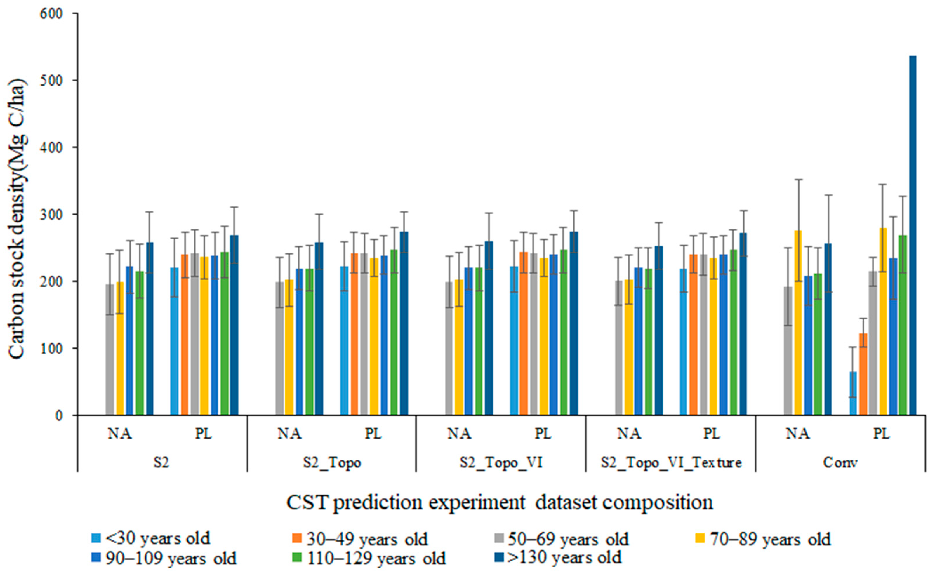
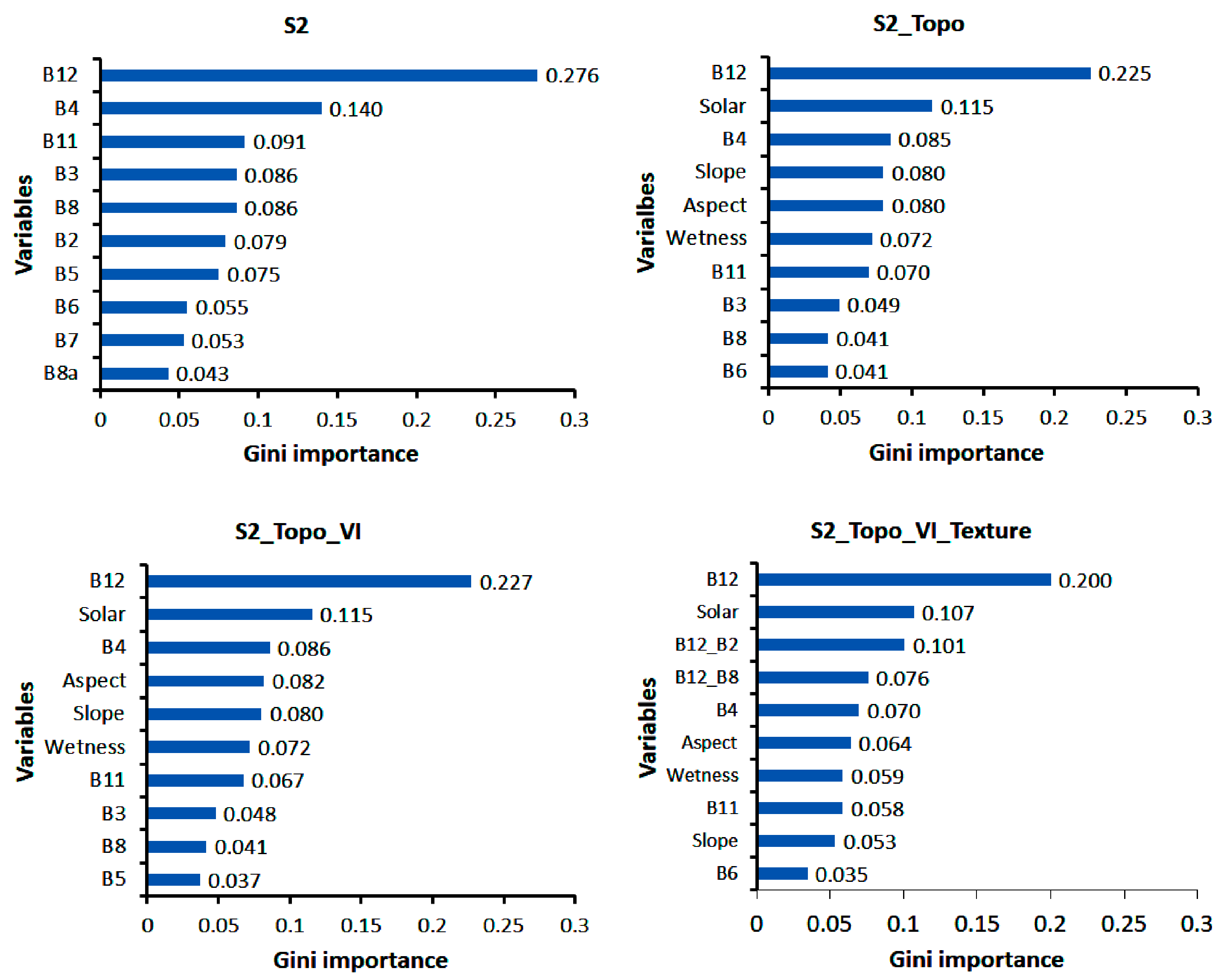
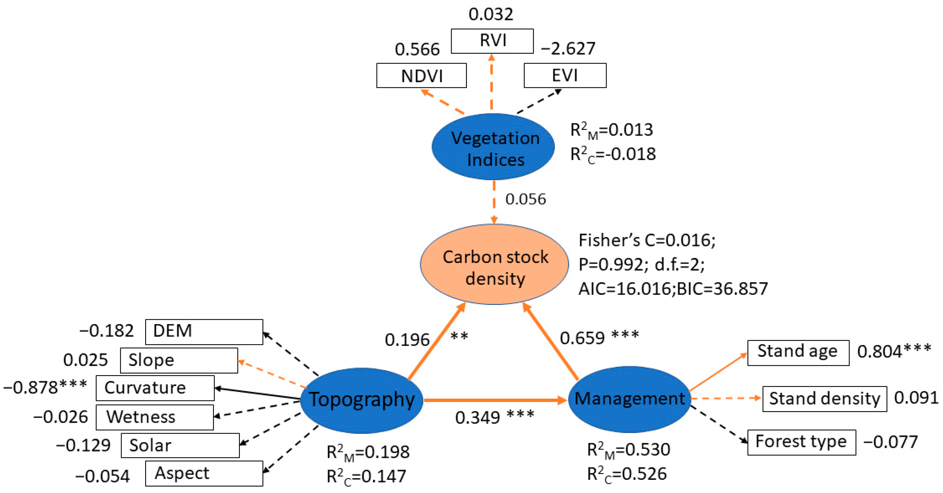
| Source | Type | Variable | |
|---|---|---|---|
| Sentinel-2A | Reflectance [63] | B2 | Blue, 492.4 nm (center wavelength) |
| B3 | Green, 559.8 nm | ||
| B4 | Red, 664.6 nm | ||
| B5 | VNIR, 704.1 nm | ||
| B6 | VNIR, 740.5 nm | ||
| B7 | VNIR, 782.8 nm | ||
| B8 | NIR, 832.8 nm | ||
| B8a | VNIR, 864.7 nm | ||
| B11 | Shortwave infrared (SWIR-1), 1613.7 nm | ||
| B12 | Shortwave infrared (SWIR-2), 2202.4 nm | ||
| Vegetation Index | EVI | 2.5 (B8 − B4)/[(B8 + 6B4 − 7.5B2) + 1] [67] | |
| NDVI | (B8 − B4)/(B8 + B4) [68] | ||
| RVI | B8/B4 [69] | ||
| GLCM Texture | Variance | [70] | |
| Correlation | [70] | ||
| DEM | Topographic index | Solar | Solar radiance [71] |
| DEM | Elevation [71] | ||
| Slope | Slope angle [72] | ||
| Aspect | Aspect [71] | ||
| Cur | Plan curvature [72] | ||
| Wetness | Topographic wetness index [73] |
Disclaimer/Publisher’s Note: The statements, opinions and data contained in all publications are solely those of the individual author(s) and contributor(s) and not of MDPI and/or the editor(s). MDPI and/or the editor(s) disclaim responsibility for any injury to people or property resulting from any ideas, methods, instructions or products referred to in the content. |
© 2023 by the authors. Licensee MDPI, Basel, Switzerland. This article is an open access article distributed under the terms and conditions of the Creative Commons Attribution (CC BY) license (https://creativecommons.org/licenses/by/4.0/).
Share and Cite
Pei, H.; Owari, T.; Tsuyuki, S.; Hiroshima, T. Identifying Spatial Variation of Carbon Stock in a Warm Temperate Forest in Central Japan Using Sentinel-2 and Digital Elevation Model Data. Remote Sens. 2023, 15, 1997. https://doi.org/10.3390/rs15081997
Pei H, Owari T, Tsuyuki S, Hiroshima T. Identifying Spatial Variation of Carbon Stock in a Warm Temperate Forest in Central Japan Using Sentinel-2 and Digital Elevation Model Data. Remote Sensing. 2023; 15(8):1997. https://doi.org/10.3390/rs15081997
Chicago/Turabian StylePei, Huiqing, Toshiaki Owari, Satoshi Tsuyuki, and Takuya Hiroshima. 2023. "Identifying Spatial Variation of Carbon Stock in a Warm Temperate Forest in Central Japan Using Sentinel-2 and Digital Elevation Model Data" Remote Sensing 15, no. 8: 1997. https://doi.org/10.3390/rs15081997
APA StylePei, H., Owari, T., Tsuyuki, S., & Hiroshima, T. (2023). Identifying Spatial Variation of Carbon Stock in a Warm Temperate Forest in Central Japan Using Sentinel-2 and Digital Elevation Model Data. Remote Sensing, 15(8), 1997. https://doi.org/10.3390/rs15081997


