
Spatial Multi-Criteria Analysis of Water-Covered Areas: District City of Katowice—Case Study


Abstract
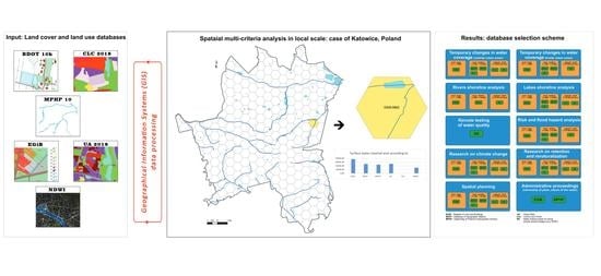
1. Introduction
2. Study Area
3. Materials and Methods
3.1. Geospatial Data Collections
- Corine Land Cover 2018 (CLC), a cover element defined by codes 511 (watercourses) and 512 (water reservoirs) [35]. This is a land cover inventory for the European region, divided into 44 classes in the years 1990–2018. The data was published in four editions and the most recent one from 2018 was used in the article [36]. The classification was made as part of the EU Copernicus program, using the method of visual interpretation of satellite images, hence the scale to which this database corresponds is 1:10,000 [37].
- Urban Atlas 2018 (UA), cover elements marked with the code 5000 (water) [38]. This was the first project in which area monitoring was carried out in “hot spots” (several hundred cities in the European Union and EFTA). The land cover classification was also performed under the Copernicus project using a combined method:(statistical) image classification and visual interpretation. The input data were satellite images of the SPOT 5 and 6 and Formosat-2 missions with a spatial resolution (GSD) of 2 to 2.5 m, hence the base corresponds to a scale of 1:1000. Data on the land cover were published in three editions, of which the last one from 2018 included 788 functional urban areas (FUA) with a population of 50,000 or more, for which 27 classes of land cover were distinguished [38,39].
- Database of Topographic Objects 10 k (BDOT), a linear layer assigned with the SWRS_L code (river and stream) and a polygonal layer with objects marked with the PTWP code (surface water) [40]. This is a database covering the land cover and location of other topographical objects (points, lines) in Poland. The resolution corresponds to a topographic map at a scale of 1:10,000. It was created and is being updated by the Head Office of Geodesy and Cartography as part of the Georeference Database of Topographic Objects project, and the national management system. BDOT is developed based on digital orthophotomap vectorization, field measurements and data from public institutions. The Database of Topographic Objects is widely available as part of services and for download in vector form. It is reference data for strategic and planning purposes or in state administration [41,42,43].
- Map of the Hydrographic Division of Poland (MPHP), a linear layer of distinguished watercourses and merged polygonal layers: lakes_highlighted and lakes_nothighlighted [44]. It presents the Polish hydrographic network. Digital MPHP was created through the digitization and vectorization of analog maps of the hydrographic division of Poland. The digital version of this map consists mainly of linear layers presenting the course of natural watercourses. Lakes and water reservoirs are drawn as polygons. Currently, the MPHP layers represent the Polish hydrographic network at a scale of 1:10,000. This map is, among others, the basis for reporting to the European Commission and it is a reference source in studies created for the implementation in Poland of the aims set by European directives: 2000/60/EC (the so-called Water Framework Directive) and Directive 2007/60/EC (the so-called Floods Directive). MPHP 10 is considered to be the basic reference hydrographic database in Poland [44,45,46].
- Register of Lands and Buildings (EGiB), based on the GML text-graphic file, a polygon layer was generated indicating the range of land use: “Wp”—land under flowing surface waters and “Ws”—land under stagnant surface waters [47]. This is a database covering Poland’s territory, consisting of subject and personal data for plots, units and precincts. It is an element of the Polish spatial information system maintained for the society in accordance with the assumptions of the INSPIRE directive. EGiB includes information on land, buildings and premises as well as their owners and legal status. It is a reference register for local government administration for tax, social, land and mortgage registration purposes, and real estate management, and is the input data for spatial planning [47,48,49]. The geometry of the objects is based on geodetic measurements, hence the data in this database are highly precise. From the point of view of the research, the most important part of EGiB is the land classification, which regulates, among others, the possibility of civil transactions in real estate (marking the land with the use of “Wp”—flowing waters (in Polish: wody płynące) precludes, for example, the sale of a plot).
- from the public Copernicus Earth Surface Monitoring website: https://land.copernicus.eu/ (in the case of CLC and UA) (accessed on 15 January 2023),
- from the resources of the State Water Holding Polish Waters (in the case of MPHP),
- from a publicly available national geoportal: https://geoportal.gov.pl/ (in the case of BDOT) (accessed on 28 January 2023),
- from the public register of the Katowice City Hall Geodesy Office (in the case of EGiB).
3.2. NDWI
3.3. Spatial Multi-Criteria Analysis
- 0—characterizing hexagons in which none of the compared databases indicated the presence of surface waters,
- Low—characterizing hexagons in which the discrepancy value was greater than 0 but maximally equal to 0.4 ha; this range was estimated using the method of Natural Breaks (Jenks) and the upper value corresponded to the average discrepancy between EGiB and BDOT; it was assumed that such a size of discrepancies between databases does not disturb the analyses,
- Acceptable—characterizing hexagons in which the discrepancy value was in the range of 0.4 ha to 0.8 ha; it was estimated using the Natural Breaks (Jenks) method, and the upper value corresponded to the standard deviation of the discrepancy between EGiB and BDOT; it was assumed that while such a size of discrepancies between databases may disturb the analysis, it is still acceptable,
- High—characterizing hexagons in which the discrepancy value was between 0.8 ha and 2.7 ha; it was estimated using the method of Natural Breaks (Jenks), and the upper value is equal to half the maximum discrepancy between EGiB and BDOT; it was assumed that such a size of discrepancies between databases indicates the need to improve data,
- Unacceptable—characterizing hexagons with a discrepancy value greater than 2.7 ha. This is a critical value excluding the simultaneous use of considered databases in the analyses.
4. Results
4.1. Polygon Layers
4.2. Remote Sensing Data and Analyzed Databases
4.3. EGiB in Relation to Linear Layers
5. Discussion
6. Conclusions
Author Contributions
Funding
Data Availability Statement
Acknowledgments
Conflicts of Interest
Appendix A


| Hexagon Number | Hexagon Area [sq. m] | Water Area by EGiB [sq. m] | Water Area by BDOT [sq. m] | Water Area by MPHP [sq. m] | Water Area by UA [sq. m] | Water Area by CLC [sq. m] | Water Area by NDWI [sq. m] | River Length by BDOT [m] | River Length by MPHP [m] |
|---|---|---|---|---|---|---|---|---|---|
| 0350-0660 | 167,745.91 | 5743.03 | 0.00 | 78.97 | 0.00 | 0.00 | 0.00 | 566.94 | 49.72 |
| 0350-0662 | 312,553.38 | 0.00 | 313.04 | 0.00 | 0.00 | 0.00 | 0.00 | 0.00 | 0.00 |
| 0350-0664 | 101,987.40 | 0.00 | 0.00 | 0.00 | 0.00 | 16,217.94 | 0.00 | 0.00 | 0.00 |
| 0351-0661 | 210,448.33 | 11,327.85 | 0.00 | 0.00 | 0.00 | 0.00 | 0.00 | 730.73 | 0.00 |
| 0351-0662 | 415,757.26 | 11,977.32 | 0.00 | 310.95 | 0.00 | 0.00 | 272.98 | 1638.06 | 0.00 |
| 0351-0663 | 628,665.11 | 431.21 | 0.00 | 0.00 | 0.00 | 0.00 | 0.00 | 0.00 | 0.00 |
| 0351-0664 | 37,2841.17 | 8071.92 | 0.00 | 0.00 | 0.00 | 0.00 | 2511.35 | 782.38 | 0.00 |
| 0351-0665 | 2332.80 | 0.00 | 0.00 | 0.00 | 0.00 | 0.00 | 0.00 | 0.00 | 0.00 |
| 0351-0666 | 88,207.48 | 780.58 | 0.00 | 0.00 | 0.00 | 0.00 | 0.00 | 845.03 | 0.00 |
| 0352-0661 | 88,009.04 | 12,978.89 | 405.77 | 0.00 | 0.00 | 0.00 | 0.00 | 698.25 | 0.00 |
| 0352-0662 | 552,236.25 | 12,013.01 | 0.00 | 0.00 | 0.00 | 0.00 | 1091.94 | 570.29 | 0.00 |
| 0352-0663 | 649,516.24 | 11,351.66 | 0.00 | 0.00 | 0.00 | 0.00 | 8582.76 | 0.00 | 0.00 |
| 0352-0664 | 649,516.24 | 11,788.74 | 2318.68 | 4250.65 | 0.00 | 0.00 | 0.00 | 0.00 | 0.00 |
| 0352-0665 | 649,516.24 | 148.75 | 8833.44 | 7950.22 | 0.00 | 0.00 | 10,996.94 | 0.00 | 0.00 |
| 0352-0666 | 649,516.24 | 0.00 | 0.00 | 0.00 | 0.00 | 0.00 | 0.00 | 0.00 | 2656.11 |
| 0352-0667 | 467,334.92 | 0.00 | 0.00 | 0.00 | 0.00 | 0.00 | 0.00 | 860.53 | 0.00 |
| 0352-0668 | 649,516.24 | 0.00 | 0.00 | 0.00 | 0.00 | 0.00 | 0.00 | 0.00 | 4504.83 |
| 0352-0669 | 214,960.22 | 0.00 | 0.00 | 0.00 | 0.00 | 0.00 | 0.00 | 0.00 | 0.00 |
| 0352-0670 | 573,809.46 | 1237.58 | 0.00 | 0.00 | 0.00 | 0.00 | 272.99 | 0.00 | 0.00 |
| 0352-0671 | 23,761.41 | 0.00 | 0.00 | 0.00 | 0.00 | 0.00 | 0.00 | 0.00 | 0.00 |
| 0352-0672 | 427,109.41 | 0.00 | 0.00 | 0.00 | 0.00 | 0.00 | 272.99 | 0.00 | 0.00 |
| 0352-0673 | 7484.86 | 0.00 | 0.00 | 0.00 | 0.00 | 0.00 | 0.00 | 0.00 | 0.00 |
| 0352-0674 | 401,719.27 | 454.77 | 432.05 | 797.46 | 0.00 | 0.00 | 272.99 | 0.00 | 0.00 |
| 0352-0676 | 86,475.55 | 994.00 | 0.00 | 0.00 | 0.00 | 0.00 | 0.00 | 0.00 | 0.00 |
| 0352-0680 | 239,107.52 | 0.00 | 0.00 | 0.00 | 0.00 | 0.00 | 0.00 | 0.00 | 0.00 |
| 0352-0682 | 26.24 | 0.00 | 0.00 | 0.00 | 0.00 | 0.00 | 0.00 | 0.00 | 0.00 |
| 0353-0648 | 442.71 | 0.00 | 0.00 | 0.00 | 0.00 | 0.00 | 0.00 | 0.00 | 0.00 |
| 0353-0650 | 135,889.84 | 886.42 | 266.93 | 0.00 | 0.00 | 0.00 | 378.58 | 0.00 | 0.00 |
| 0353-0652 | 397,590.53 | 0.00 | 0.00 | 0.00 | 0.00 | 0.00 | 16,119.90 | 0.00 | 0.00 |
| 0353-0654 | 389,638.75 | 349.52 | 0.00 | 0.00 | 0.00 | 0.00 | 0.00 | 0.00 | 0.00 |
| 0353-0656 | 234,716.58 | 0.00 | 0.00 | 0.00 | 0.00 | 0.00 | 0.00 | 0.00 | 0.00 |
| 0353-0658 | 300,304.13 | 0.00 | 674.96 | 588.39 | 0.00 | 0.00 | 0.00 | 0.00 | 0.00 |
| 0353-0660 | 563,294.10 | 5147.81 | 586.09 | 559.10 | 0.00 | 0.00 | 1092.09 | 704.13 | 0.00 |
| 0353-0661 | 371,646.99 | 14,688.03 | 0.00 | 215.09 | 0.00 | 0.00 | 811.16 | 171.04 | 0.00 |
| 0353-0662 | 649,516.24 | 7748.77 | 28.01 | 288.77 | 0.00 | 0.00 | 2348.08 | 0.00 | 0.00 |
| 0353-0663 | 649,516.24 | 9930.90 | 0.00 | 0.00 | 0.00 | 0.00 | 1357.21 | 0.00 | 0.00 |
| 0353-0664 | 649,516.24 | 23,329.28 | 9315.87 | 8698.25 | 0.00 | 0.00 | 921.75 | 5727.87 | 0.00 |
| 0353-0665 | 649,516.24 | 0.00 | 0.00 | 0.00 | 0.00 | 0.00 | 0.00 | 0.00 | 0.00 |
| 0353-0666 | 649,516.24 | 0.00 | 493.61 | 606.30 | 0.00 | 0.00 | 10,857.66 | 0.00 | 0.00 |
| 0353-0667 | 649,516.24 | 0.00 | 0.00 | 399.06 | 0.00 | 0.00 | 0.00 | 0.00 | 0.00 |
| 0353-0668 | 649,516.24 | 3501.55 | 2144.60 | 5324.17 | 0.00 | 0.00 | 2728.37 | 0.00 | 0.00 |
| 0353-0669 | 649,516.24 | 0.00 | 0.00 | 0.00 | 0.00 | 0.00 | 0.00 | 0.00 | 0.00 |
| 0353-0670 | 649,516.24 | 5629.59 | 0.00 | 668.27 | 0.00 | 0.00 | 0.00 | 0.00 | 0.00 |
| 0353-0671 | 649,516.24 | 0.00 | 0.00 | 0.00 | 0.00 | 0.00 | 545.97 | 0.00 | 0.00 |
| 0353-0672 | 649,516.24 | 4685.47 | 1483.50 | 1484.24 | 0.00 | 0.00 | 273.06 | 0.00 | 0.00 |
| 0353-0673 | 649,516.24 | 1199.29 | 0.00 | 0.00 | 0.00 | 0.00 | 1119.21 | 0.00 | 0.00 |
| 0353-0674 | 649,516.24 | 10,806.18 | 1733.36 | 1950.11 | 0.00 | 0.00 | 273.10 | 0.00 | 0.00 |
| 0353-0675 | 630,456.97 | 3984.83 | 2514.55 | 630.68 | 0.00 | 0.00 | 2185.65 | 0.00 | 1741.05 |
| 0353-0676 | 649,516.24 | 2782.31 | 0.00 | 0.00 | 0.00 | 0.00 | 272.99 | 1957.19 | 1843.89 |
| 0353-0677 | 312,945.32 | 1123.58 | 957.75 | 907.92 | 0.00 | 0.00 | 0.00 | 0.00 | 0.00 |
| 0353-0678 | 649,516.24 | 1210.30 | 0.00 | 145.98 | 0.00 | 0.00 | 0.00 | 0.00 | 0.00 |
| 0353-0679 | 516,915.43 | 0.00 | 0.00 | 0.00 | 0.00 | 0.00 | 0.00 | 0.00 | 0.00 |
| 0353-0680 | 179,489.90 | 0.00 | 0.00 | 0.00 | 0.00 | 0.00 | 0.00 | 0.00 | 0.00 |
| 0353-0681 | 133,181.02 | 0.00 | 0.00 | 0.00 | 0.00 | 0.00 | 0.00 | 0.00 | 956.62 |
| 0354-0647 | 219,810.52 | 0.00 | 0.00 | 0.00 | 0.00 | 0.00 | 272.99 | 0.00 | 0.00 |
| 0354-0648 | 257,082.57 | 3231.07 | 3266.40 | 2657.45 | 0.00 | 0.00 | 546.05 | 0.00 | 0.00 |
| 0354-0649 | 629,023.12 | 9336.09 | 2880.29 | 0.00 | 0.00 | 0.00 | 682.05 | 0.00 | 0.00 |
| 0354-0650 | 649,516.24 | 12,231.22 | 67,169.38 | 62,324.16 | 59,249.91 | 0.00 | 46,580.30 | 0.00 | 0.00 |
| 0354-0651 | 649,516.24 | 11,024.92 | 6447.95 | 6401.56 | 0.00 | 0.00 | 14,081.42 | 0.00 | 0.00 |
| 0354-0652 | 649,516.24 | 0.00 | 0.00 | 0.00 | 0.00 | 0.00 | 4429.54 | 0.00 | 0.00 |
| 0354-0653 | 649,516.24 | 0.00 | 0.00 | 0.00 | 0.00 | 0.00 | 11,436.81 | 0.00 | 0.00 |
| 0354-0654 | 649,516.24 | 0.00 | 0.00 | 0.00 | 0.00 | 0.00 | 12,551.21 | 0.00 | 0.00 |
| 0354-0655 | 649,516.24 | 0.00 | 0.00 | 0.00 | 0.00 | 0.00 | 3692.40 | 0.00 | 0.00 |
| 0354-0656 | 649,516.24 | 25,607.19 | 4325.91 | 12,836.72 | 10,114.49 | 0.00 | 819.24 | 0.00 | 0.00 |
| 0354-0657 | 649,516.24 | 0.00 | 768.27 | 910.41 | 0.00 | 0.00 | 0.00 | 0.00 | 0.00 |
| 0354-0658 | 649,516.24 | 0.00 | 190.36 | 0.00 | 0.00 | 0.00 | 1181.03 | 0.00 | 0.00 |
| 0354-0659 | 649,516.24 | 0.00 | 0.00 | 0.00 | 0.00 | 0.00 | 0.00 | 0.00 | 0.00 |
| 0354-0660 | 649,516.24 | 0.00 | 0.00 | 0.00 | 0.00 | 0.00 | 5686.49 | 0.00 | 0.00 |
| 0354-0661 | 649,516.24 | 12,222.99 | 271.90 | 276.02 | 0.00 | 0.00 | 4813.71 | 3460.65 | 0.00 |
| 0354-0662 | 649,516.24 | 10,881.45 | 518.03 | 441.10 | 0.00 | 0.00 | 5040.84 | 36.53 | 9231.20 |
| 0354-0663 | 649,516.24 | 878.81 | 671.88 | 762.99 | 0.00 | 0.00 | 3828.69 | 0.00 | 0.00 |
| 0354-0664 | 649,516.24 | 5756.21 | 0.00 | 0.00 | 0.00 | 0.00 | 1092.11 | 0.00 | 0.00 |
| 0354-0665 | 649,516.24 | 17,070.09 | 3048.90 | 5644.91 | 0.00 | 0.00 | 2730.35 | 0.00 | 0.00 |
| 0354-0666 | 649,516.24 | 1253.62 | 0.00 | 0.00 | 0.00 | 0.00 | 10,351.57 | 0.00 | 0.00 |
| 0354-0667 | 649,516.24 | 1159.66 | 0.00 | 0.00 | 0.00 | 0.00 | 10,142.74 | 0.00 | 0.00 |
| 0354-0668 | 649,516.24 | 4000.29 | 0.00 | 280.72 | 0.00 | 0.00 | 3825.96 | 0.00 | 0.00 |
| 0354-0669 | 649,516.24 | 6385.94 | 840.86 | 2392.09 | 0.00 | 0.00 | 545.98 | 4768.82 | 0.00 |
| 0354-0670 | 649,516.24 | 429.20 | 355.50 | 383.87 | 0.00 | 0.00 | 3274.49 | 0.00 | 0.00 |
| 0354-0671 | 649,516.24 | 419.23 | 0.00 | 0.00 | 0.00 | 0.00 | 544.38 | 0.00 | 0.00 |
| 0354-0672 | 649,516.24 | 3121.38 | 0.00 | 0.00 | 0.00 | 0.00 | 819.02 | 0.00 | 0.00 |
| 0354-0673 | 649,516.24 | 2943.41 | 0.00 | 0.00 | 0.00 | 0.00 | 1076.37 | 0.00 | 0.00 |
| 0354-0674 | 649,516.24 | 3979.28 | 0.00 | 0.00 | 0.00 | 0.00 | 561.51 | 2244.32 | 0.00 |
| 0354-0675 | 649,516.24 | 15,319.72 | 0.00 | 254.23 | 0.00 | 0.00 | 1365.17 | 1038.76 | 0.00 |
| 0354-0676 | 649,516.24 | 18,207.74 | 28,728.59 | 34,611.67 | 36,935.61 | 0.00 | 10,528.71 | 582.67 | 9731.33 |
| 0354-0677 | 649,516.24 | 0.00 | 0.00 | 0.00 | 0.00 | 0.00 | 0.00 | 0.00 | 0.00 |
| 0354-0678 | 363,548.22 | 0.00 | 0.00 | 7609.61 | 0.00 | 0.00 | 1196.70 | 0.00 | 0.00 |
| 0354-0679 | 283,940.47 | 256.19 | 260.10 | 0.00 | 0.00 | 0.00 | 0.00 | 0.00 | 0.00 |
| 0355-0644 | 2904.01 | 0.00 | 0.00 | 0.00 | 0.00 | 0.00 | 0.00 | 0.00 | 0.00 |
| 0355-0649 | 68,191.88 | 0.00 | 0.00 | 0.00 | 0.00 | 0.00 | 0.00 | 0.00 | 0.00 |
| 0355-0650 | 416,873.03 | 0.00 | 0.00 | 0.00 | 0.00 | 0.00 | 7152.75 | 0.00 | 0.00 |
| 0355-0651 | 596,055.84 | 19,174.09 | 26,778.44 | 19,463.05 | 18,157.42 | 0.00 | 12,308.75 | 3678.14 | 0.00 |
| 0355-0652 | 649,516.24 | 14,965.10 | 5531.40 | 0.00 | 0.00 | 0.00 | 12,150.89 | 0.00 | 0.00 |
| 0355-0653 | 649,516.24 | 0.00 | 0.00 | 0.00 | 0.00 | 0.00 | 26,076.49 | 0.00 | 0.00 |
| 0355-0654 | 649,516.24 | 0.00 | 0.00 | 0.00 | 0.00 | 0.00 | 4332.78 | 672.38 | 0.00 |
| 0355-0655 | 649,516.24 | 1776.87 | 1373.54 | 1377.74 | 0.00 | 0.00 | 9144.31 | 0.00 | 0.00 |
| 0355-0656 | 649,516.24 | 0.00 | 0.00 | 0.00 | 0.00 | 0.00 | 9467.91 | 0.00 | 0.00 |
| 0355-0657 | 649,516.24 | 0.00 | 0.00 | 0.00 | 0.00 | 0.00 | 10,369.04 | 0.00 | 0.00 |
| 0355-0658 | 649,516.24 | 3868.95 | 4237.86 | 2856.30 | 0.00 | 0.00 | 1638.00 | 0.00 | 0.00 |
| 0355-0659 | 649,516.24 | 22,255.00 | 24,196.51 | 34,519.00 | 15,204.11 | 0.00 | 7702.39 | 0.00 | 0.00 |
| 0355-0660 | 649,516.24 | 2741.08 | 1715.57 | 1773.01 | 0.00 | 0.00 | 2085.78 | 0.00 | 0.00 |
| 0355-0661 | 649,516.24 | 517.69 | 0.00 | 1007.14 | 0.00 | 0.00 | 6005.26 | 1276.62 | 0.00 |
| 0355-0662 | 649,516.24 | 131.18 | 0.00 | 2943.95 | 0.00 | 0.00 | 7328.29 | 413.97 | 0.00 |
| 0355-0663 | 649,516.24 | 4393.73 | 0.00 | 0.00 | 0.00 | 0.00 | 20,810.26 | 0.00 | 0.00 |
| 0355-0664 | 649,516.24 | 0.00 | 0.00 | 0.00 | 0.00 | 0.00 | 4657.13 | 1055.54 | 0.00 |
| 0355-0665 | 649,516.24 | 8350.88 | 0.00 | 0.00 | 0.00 | 0.00 | 8700.77 | 0.00 | 9483.97 |
| 0355-0666 | 649,516.24 | 7194.27 | 0.00 | 0.00 | 0.00 | 0.00 | 1737.08 | 0.00 | 0.00 |
| 0355-0667 | 649,516.24 | 469.04 | 0.00 | 0.00 | 0.00 | 0.00 | 2573.77 | 0.00 | 0.00 |
| 0355-0668 | 649,516.24 | 1094.46 | 0.00 | 3718.52 | 0.00 | 0.00 | 272.99 | 1419.77 | 0.00 |
| 0355-0669 | 649,516.24 | 0.00 | 0.00 | 0.00 | 0.00 | 0.00 | 4142.15 | 0.00 | 0.00 |
| 0355-0670 | 649,516.24 | 0.00 | 0.00 | 0.00 | 0.00 | 0.00 | 273.03 | 0.00 | 0.00 |
| 0355-0671 | 649,516.24 | 0.00 | 0.00 | 0.00 | 0.00 | 0.00 | 3266.64 | 48.35 | 0.00 |
| 0355-0672 | 649,516.24 | 4377.45 | 421.95 | 437.30 | 0.00 | 0.00 | 495.88 | 642.25 | 0.00 |
| 0355-0673 | 649,516.24 | 2003.58 | 0.00 | 0.00 | 0.00 | 0.00 | 272.99 | 0.00 | 3204.40 |
| 0355-0674 | 649,516.24 | 1061.24 | 0.00 | 0.00 | 0.00 | 0.00 | 1415.13 | 229.45 | 0.00 |
| 0355-0675 | 649,516.24 | 0.00 | 0.00 | 0.00 | 0.00 | 0.00 | 0.00 | 0.00 | 0.00 |
| 0355-0676 | 481,897.52 | 0.00 | 0.00 | 0.00 | 0.00 | 0.00 | 0.00 | 0.00 | 0.00 |
| 0355-0677 | 493,565.53 | 31,630.46 | 4738.12 | 4853.05 | 0.00 | 0.00 | 0.00 | 1176.79 | 0.00 |
| 0355-0678 | 37,200.21 | 5748.01 | 0.00 | 0.00 | 0.00 | 0.00 | 0.00 | 54.89 | 0.00 |
| 0355-0679 | 90.81 | 0.00 | 0.00 | 0.00 | 0.00 | 0.00 | 0.00 | 0.00 | 0.00 |
| 0356-0645 | 278,075.32 | 0.00 | 0.00 | 0.00 | 0.00 | 0.00 | 2832.40 | 0.00 | 0.00 |
| 0356-0646 | 274,117.16 | 0.00 | 0.00 | 0.00 | 0.00 | 0.00 | 1092.04 | 0.00 | 0.00 |
| 0356-0647 | 520,308.12 | 0.00 | 0.00 | 0.00 | 0.00 | 0.00 | 2183.92 | 0.00 | 0.00 |
| 0356-0648 | 649,516.24 | 7816.25 | 5297.87 | 5730.79 | 11,605.36 | 0.00 | 16,463.83 | 0.00 | 0.00 |
| 0356-0649 | 605,837.33 | 0.00 | 0.00 | 0.00 | 0.00 | 0.00 | 2457.10 | 0.00 | 0.00 |
| 0356-0650 | 649,516.24 | 0.00 | 0.00 | 0.00 | 0.00 | 0.00 | 6694.16 | 0.00 | 0.00 |
| 0356-0651 | 649,516.24 | 0.00 | 0.00 | 0.00 | 0.00 | 0.00 | 28,168.22 | 0.00 | 0.00 |
| 0356-0652 | 649,516.24 | 1059.72 | 219.58 | 0.00 | 0.00 | 0.00 | 15,782.06 | 0.00 | 0.00 |
| 0356-0653 | 649,516.24 | 15,673.01 | 5762.18 | 0.00 | 0.00 | 0.00 | 24,773.57 | 1148.62 | 0.00 |
| 0356-0654 | 649,516.24 | 3232.21 | 1377.12 | 0.00 | 0.00 | 0.00 | 77,740.87 | 617.78 | 0.00 |
| 0356-0655 | 649,516.24 | 0.00 | 0.00 | 0.00 | 0.00 | 0.00 | 22,696.40 | 0.00 | 0.00 |
| 0356-0656 | 649,516.24 | 0.00 | 381.72 | 382.88 | 0.00 | 0.00 | 35,521.72 | 0.00 | 0.00 |
| 0356-0657 | 649,516.24 | 0.00 | 0.00 | 414.80 | 0.00 | 0.00 | 8379.18 | 0.00 | 0.00 |
| 0356-0658 | 649,516.24 | 43,024.98 | 31,765.94 | 50,912.23 | 29,586.35 | 0.00 | 24,337.70 | 0.00 | 0.00 |
| 0356-0659 | 649,516.24 | 0.00 | 0.00 | 9852.27 | 0.00 | 0.00 | 4365.30 | 0.00 | 0.00 |
| 0356-0660 | 649,516.24 | 13,446.97 | 10,545.19 | 10,467.34 | 11,693.34 | 0.00 | 4955.54 | 0.00 | 0.00 |
| 0356-0661 | 649,516.24 | 0.00 | 0.00 | 0.00 | 0.00 | 0.00 | 545.99 | 0.00 | 0.00 |
| 0356-0662 | 649,516.24 | 0.00 | 0.00 | 0.00 | 0.00 | 0.00 | 0.00 | 2315.72 | 0.00 |
| 0356-0663 | 649,516.24 | 0.00 | 0.00 | 0.00 | 0.00 | 0.00 | 0.00 | 0.00 | 0.00 |
| 0356-0664 | 649,516.24 | 0.00 | 0.00 | 0.00 | 0.00 | 0.00 | 0.00 | 0.00 | 0.00 |
| 0356-0665 | 649,516.24 | 0.00 | 616.21 | 2538.29 | 0.00 | 0.00 | 0.00 | 3192.37 | 2805.38 |
| 0356-0666 | 649,516.24 | 0.00 | 18,115.68 | 4311.99 | 0.00 | 0.00 | 0.00 | 0.00 | 0.00 |
| 0356-0667 | 649,516.24 | 0.00 | 0.00 | 0.00 | 0.00 | 0.00 | 171.00 | 0.00 | 0.00 |
| 0356-0668 | 649,516.24 | 0.00 | 9174.81 | 11,608.00 | 0.00 | 0.00 | 818.99 | 140.99 | 0.00 |
| 0356-0669 | 649,516.24 | 0.00 | 10,893.99 | 13,676.22 | 0.00 | 0.00 | 0.00 | 1028.38 | 0.00 |
| 0356-0670 | 649,516.24 | 0.00 | 0.00 | 11,010.74 | 0.00 | 0.00 | 1346.16 | 0.00 | 0.00 |
| 0356-0671 | 649,516.24 | 0.00 | 0.00 | 0.00 | 0.00 | 0.00 | 0.00 | 0.00 | 0.00 |
| 0356-0672 | 649,516.24 | 0.00 | 0.00 | 0.00 | 0.00 | 0.00 | 56.85 | 0.00 | 0.00 |
| 0356-0673 | 649,516.24 | 648.28 | 0.00 | 3143.00 | 0.00 | 0.00 | 1581.02 | 0.00 | 0.00 |
| 0356-0674 | 649,516.24 | 0.00 | 310.15 | 5170.86 | 0.00 | 0.00 | 0.00 | 0.00 | 0.00 |
| 0356-0675 | 636,637.14 | 0.00 | 0.00 | 3229.87 | 0.00 | 0.00 | 11,057.35 | 0.00 | 787.19 |
| 0356-0676 | 260,560.70 | 0.00 | 0.00 | 0.00 | 0.00 | 0.00 | 1975.97 | 0.00 | 0.00 |
| 0356-0677 | 6540.99 | 0.00 | 0.00 | 0.00 | 0.00 | 0.00 | 0.00 | 0.00 | 0.00 |
| 0357-0647 | 215,397.16 | 0.00 | 0.00 | 0.00 | 0.00 | 0.00 | 19,413.00 | 0.00 | 0.00 |
| 0357-0648 | 4759.18 | 0.00 | 0.00 | 0.00 | 0.00 | 0.00 | 0.00 | 0.00 | 0.00 |
| 0357-0649 | 562,722.96 | 0.00 | 0.00 | 138.26 | 0.00 | 0.00 | 2221.10 | 0.00 | 0.00 |
| 0357-0650 | 618,885.03 | 0.00 | 81.35 | 34.32 | 0.00 | 0.00 | 3783.21 | 0.00 | 0.00 |
| 0357-0651 | 649,516.24 | 0.00 | 0.00 | 0.00 | 0.00 | 0.00 | 9409.77 | 0.00 | 0.00 |
| 0357-0652 | 649,516.24 | 0.00 | 0.00 | 0.00 | 0.00 | 0.00 | 7509.95 | 0.00 | 0.00 |
| 0357-0653 | 649,516.24 | 8056.07 | 3540.92 | 0.00 | 0.00 | 0.00 | 20,608.29 | 1713.80 | 0.00 |
| 0357-0654 | 649,516.24 | 21,903.84 | 8644.44 | 3350.57 | 5327.49 | 5994.20 | 14,365.95 | 482.34 | 0.00 |
| 0357-0655 | 649,516.24 | 0.00 | 0.00 | 0.00 | 0.00 | 0.00 | 27,828.64 | 0.00 | 0.00 |
| 0357-0656 | 649,516.24 | 128,791.39 | 121,207.98 | 121,865.63 | 126,055.03 | 172,840.88 | 100,639.57 | 848.28 | 0.00 |
| 0357-0657 | 649,516.24 | 6302.16 | 4810.46 | 4807.49 | 9942.00 | 0.00 | 11,328.09 | 0.00 | 0.00 |
| 0357-0658 | 649,516.24 | 98,520.34 | 92,710.98 | 92,188.41 | 94,886.95 | 147,672.15 | 65,415.22 | 648.07 | 0.00 |
| 0357-0659 | 649,516.24 | 0.00 | 0.00 | 380.14 | 0.00 | 0.00 | 2995.37 | 0.00 | 0.00 |
| 0357-0660 | 649,516.24 | 15,479.19 | 44,203.47 | 43,522.75 | 43,191.78 | 0.00 | 24,508.42 | 876.56 | 0.00 |
| 0357-0661 | 649,516.24 | 3095.92 | 17,031.20 | 16,913.87 | 11,861.99 | 0.00 | 538.27 | 0.00 | 5745.27 |
| 0357-0662 | 649,516.24 | 0.00 | 0.00 | 0.00 | 0.00 | 0.00 | 3187.15 | 0.00 | 0.00 |
| 0357-0663 | 649,516.24 | 0.00 | 0.00 | 0.00 | 0.00 | 0.00 | 0.00 | 0.00 | 0.00 |
| 0357-0664 | 649,516.24 | 0.00 | 46,597.04 | 45,951.94 | 50,677.02 | 0.00 | 37,953.87 | 76.31 | 0.00 |
| 0357-0665 | 649,516.24 | 0.00 | 0.00 | 0.00 | 0.00 | 0.00 | 0.00 | 938.52 | 0.00 |
| 0357-0666 | 649,516.24 | 0.00 | 6611.96 | 4971.13 | 5034.83 | 0.00 | 8784.54 | 969.92 | 0.00 |
| 0357-0667 | 649,516.24 | 0.00 | 10,557.44 | 8545.83 | 0.00 | 0.00 | 0.00 | 0.00 | 0.00 |
| 0357-0668 | 649,516.24 | 0.00 | 0.00 | 0.00 | 0.00 | 0.00 | 2547.16 | 0.00 | 0.00 |
| 0357-0669 | 649,516.24 | 0.00 | 726.49 | 989.60 | 0.00 | 0.00 | 273.03 | 271.81 | 0.00 |
| 0357-0670 | 649,516.24 | 0.00 | 0.00 | 0.00 | 0.00 | 0.00 | 3152.53 | 0.00 | 0.00 |
| 0357-0671 | 649,516.24 | 1333.11 | 0.00 | 0.00 | 0.00 | 0.00 | 849.92 | 0.00 | 0.00 |
| 0357-0672 | 649,516.24 | 0.00 | 0.00 | 0.00 | 0.00 | 0.00 | 780.35 | 0.00 | 0.00 |
| 0357-0673 | 649,516.24 | 0.00 | 0.00 | 0.00 | 0.00 | 0.00 | 0.00 | 0.00 | 3574.03 |
| 0357-0674 | 649,516.24 | 0.00 | 0.00 | 0.00 | 0.00 | 0.00 | 0.00 | 0.00 | 0.00 |
| 0357-0675 | 649,516.24 | 0.00 | 0.00 | 0.00 | 0.00 | 0.00 | 0.00 | 0.00 | 0.00 |
| 0357-0676 | 649,516.24 | 0.00 | 0.00 | 0.00 | 0.00 | 0.00 | 0.00 | 0.00 | 0.00 |
| 0357-0677 | 451,445.24 | 0.00 | 3400.04 | 509.30 | 0.00 | 0.00 | 0.00 | 0.00 | 0.00 |
| 0357-0678 | 560,957.58 | 0.00 | 0.00 | 0.00 | 0.00 | 0.00 | 0.00 | 0.00 | 0.00 |
| 0357-0680 | 508,254.67 | 0.00 | 0.00 | 0.00 | 0.00 | 0.00 | 0.00 | 1100.45 | 0.00 |
| 0357-0681 | 34.61 | 0.00 | 0.00 | 0.00 | 0.00 | 0.00 | 0.00 | 0.00 | 0.00 |
| 0357-0682 | 495,873.26 | 403.71 | 18,108.06 | 0.00 | 0.00 | 0.00 | 12,403.48 | 140.57 | 0.00 |
| 0357-0684 | 146,990.60 | 0.00 | 0.00 | 0.00 | 0.00 | 0.00 | 0.00 | 0.00 | 0.00 |
| 0358-0644 | 120,679.13 | 0.00 | 0.00 | 0.00 | 0.00 | 0.00 | 0.00 | 0.00 | 0.00 |
| 0358-0646 | 560,160.50 | 11,194.37 | 408.16 | 330.07 | 0.00 | 0.00 | 6326.04 | 243.40 | 0.00 |
| 0358-0647 | 46,646.99 | 0.00 | 0.00 | 0.00 | 0.00 | 0.00 | 255.26 | 0.00 | 0.00 |
| 0358-0648 | 649,516.24 | 8460.65 | 0.00 | 0.00 | 0.00 | 0.00 | 5827.25 | 716.83 | 1548.99 |
| 0358-0649 | 285,773.51 | 4807.71 | 4043.41 | 8726.87 | 0.00 | 0.00 | 6216.75 | 0.00 | 0.00 |
| 0358-0650 | 649,516.24 | 710.94 | 614.28 | 0.00 | 0.00 | 0.00 | 4357.58 | 0.00 | 0.00 |
| 0358-0651 | 649,516.24 | 14,396.62 | 10,976.98 | 15,023.04 | 0.00 | 0.00 | 6887.09 | 0.00 | 0.00 |
| 0358-0652 | 649,516.24 | 0.00 | 0.00 | 0.00 | 0.00 | 0.00 | 27,981.69 | 0.00 | 0.00 |
| 0358-0653 | 649,516.24 | 16,825.12 | 5126.61 | 0.00 | 0.00 | 0.00 | 6881.26 | 959.03 | 12,077.20 |
| 0358-0654 | 649,516.24 | 12,821.20 | 2372.17 | 0.00 | 0.00 | 0.00 | 11,125.26 | 142.62 | 0.00 |
| 0358-0655 | 649,516.24 | 4839.74 | 3791.18 | 4089.19 | 4931.87 | 9982.79 | 21,764.62 | 0.00 | 0.00 |
| 0358-0656 | 649,516.24 | 0.00 | 0.00 | 0.00 | 0.00 | 0.00 | 13,843.78 | 0.00 | 0.00 |
| 0358-0657 | 649,516.24 | 47,846.69 | 45,572.35 | 45,947.79 | 46,670.57 | 68,199.70 | 34,875.96 | 43.28 | 0.00 |
| 0358-0658 | 649,516.24 | 0.00 | 0.00 | 0.00 | 0.00 | 0.00 | 811.35 | 0.00 | 0.00 |
| 0358-0659 | 649,516.24 | 20,445.62 | 17,549.22 | 15,285.95 | 17,662.78 | 28,443.71 | 11,772.17 | 592.16 | 0.00 |
| 0358-0660 | 649,516.24 | 0.00 | 358.94 | 3548.32 | 0.00 | 0.00 | 817.36 | 0.00 | 0.00 |
| 0358-0661 | 649,516.24 | 0.00 | 0.00 | 0.00 | 0.00 | 0.00 | 5196.89 | 0.00 | 0.00 |
| 0358-0662 | 649,516.24 | 17,204.74 | 4977.12 | 4856.87 | 0.00 | 0.00 | 10,700.48 | 1372.70 | 0.00 |
| 0358-0663 | 649,516.24 | 0.00 | 15,236.51 | 15,234.96 | 17,286.29 | 0.00 | 13,916.85 | 234.00 | 0.00 |
| 0358-0664 | 649,516.24 | 0.00 | 0.00 | 0.00 | 0.00 | 0.00 | 5699.79 | 0.00 | 0.00 |
| 0358-0665 | 649,516.24 | 0.00 | 583.57 | 508.42 | 230.55 | 0.00 | 185.68 | 720.08 | 0.00 |
| 0358-0666 | 649,516.24 | 0.00 | 9880.02 | 0.00 | 0.00 | 0.00 | 366.85 | 0.00 | 0.00 |
| 0358-0667 | 649,516.24 | 0.00 | 0.00 | 0.00 | 0.00 | 0.00 | 0.00 | 0.00 | 0.00 |
| 0358-0668 | 648,007.80 | 0.00 | 0.00 | 0.00 | 0.00 | 0.00 | 273.11 | 0.00 | 0.00 |
| 0358-0669 | 649,516.24 | 0.00 | 0.00 | 0.00 | 0.00 | 0.00 | 1055.56 | 0.00 | 0.00 |
| 0358-0670 | 649,516.24 | 0.00 | 3749.55 | 293.37 | 0.00 | 0.00 | 0.00 | 0.00 | 0.00 |
| 0358-0671 | 649,516.24 | 0.00 | 32.75 | 24.33 | 0.00 | 0.00 | 391.21 | 1170.44 | 0.00 |
| 0358-0672 | 649,516.24 | 0.00 | 0.00 | 0.00 | 0.00 | 0.00 | 0.00 | 596.93 | 0.00 |
| 0358-0673 | 649,516.24 | 0.00 | 0.00 | 0.00 | 0.00 | 0.00 | 0.00 | 0.00 | 0.00 |
| 0358-0674 | 649,516.24 | 0.00 | 0.00 | 0.00 | 0.00 | 0.00 | 0.00 | 0.00 | 0.00 |
| 0358-0675 | 649,516.24 | 0.00 | 0.00 | 0.00 | 0.00 | 0.00 | 0.00 | 0.00 | 0.00 |
| 0358-0676 | 649,516.24 | 0.00 | 0.00 | 0.00 | 0.00 | 0.00 | 0.00 | 0.00 | 0.00 |
| 0358-0677 | 649,516.24 | 0.00 | 0.00 | 0.00 | 0.00 | 0.00 | 0.00 | 0.00 | 0.00 |
| 0358-0678 | 649,516.24 | 0.00 | 0.00 | 0.00 | 0.00 | 0.00 | 0.00 | 2183.25 | 5072.90 |
| 0358-0679 | 649,516.24 | 0.00 | 0.00 | 0.00 | 0.00 | 0.00 | 0.00 | 641.43 | 0.00 |
| 0358-0680 | 649,516.24 | 0.00 | 1632.18 | 1637.95 | 2848.29 | 0.00 | 0.00 | 0.00 | 0.00 |
| 0358-0681 | 649,516.24 | 0.00 | 0.00 | 0.00 | 0.00 | 0.00 | 0.00 | 0.00 | 4561.96 |
| 0358-0682 | 649,516.24 | 0.00 | 10,829.23 | 10,275.04 | 11,212.10 | 0.00 | 272.98 | 0.00 | 0.00 |
| 0358-0683 | 649,516.24 | 7783.58 | 22,675.69 | 0.00 | 20,217.26 | 0.00 | 9559.71 | 1979.06 | 0.00 |
| 0358-0684 | 589,012.97 | 10,538.90 | 0.00 | 0.00 | 0.00 | 0.00 | 0.00 | 0.00 | 0.00 |
| 0358-0685 | 188,614.30 | 0.00 | 0.00 | 0.00 | 0.00 | 0.00 | 0.00 | 0.00 | 0.00 |
| 0358-0686 | 14,806.36 | 0.00 | 0.00 | 0.00 | 0.00 | 0.00 | 0.00 | 0.00 | 0.00 |
| 0359-0645 | 225,126.91 | 0.00 | 0.00 | 0.00 | 0.00 | 0.00 | 4579.00 | 0.00 | 0.00 |
| 0359-0647 | 370,159.03 | 7036.61 | 0.00 | 0.00 | 19.72 | 0.00 | 1102.84 | 0.00 | 0.00 |
| 0359-0648 | 129,804.80 | 0.00 | 0.00 | 0.00 | 0.00 | 0.00 | 819.11 | 0.00 | 0.00 |
| 0359-0649 | 596,569.78 | 5665.01 | 0.00 | 0.00 | 0.00 | 0.00 | 9406.59 | 586.47 | 0.00 |
| 0359-0650 | 649,516.24 | 265.09 | 0.39 | 346.98 | 0.00 | 0.00 | 6541.28 | 0.00 | 0.00 |
| 0359-0651 | 649,516.24 | 2242.12 | 1445.70 | 2592.97 | 0.00 | 0.00 | 7617.77 | 0.00 | 0.00 |
| 0359-0652 | 649,516.24 | 15,718.10 | 6623.44 | 0.00 | 0.00 | 0.00 | 10,949.04 | 4404.38 | 0.00 |
| 0359-0653 | 649,516.24 | 17,394.43 | 4007.97 | 0.00 | 0.00 | 0.00 | 12,303.77 | 0.00 | 0.00 |
| 0359-0654 | 649,516.24 | 0.00 | 0.00 | 8126.33 | 0.00 | 0.00 | 13,762.61 | 0.00 | 0.00 |
| 0359-0655 | 649,516.24 | 0.00 | 30,110.41 | 30,287.36 | 32,536.72 | 0.00 | 35,055.94 | 0.00 | 0.00 |
| 0359-0656 | 649,516.24 | 0.00 | 0.00 | 0.00 | 0.00 | 0.00 | 7821.21 | 0.00 | 0.00 |
| 0359-0657 | 649,516.24 | 0.00 | 7209.87 | 15,116.74 | 4366.99 | 0.00 | 7467.69 | 0.00 | 0.00 |
| 0359-0658 | 649,516.24 | 0.00 | 0.00 | 0.00 | 0.00 | 0.00 | 11,201.91 | 0.00 | 0.00 |
| 0359-0659 | 649,516.24 | 0.00 | 4457.32 | 756.76 | 0.00 | 0.00 | 3883.87 | 0.00 | 0.00 |
| 0359-0660 | 649,516.24 | 0.00 | 25,416.14 | 25,419.45 | 25,002.94 | 0.00 | 22,823.91 | 0.00 | 0.00 |
| 0359-0661 | 649,516.24 | 5309.60 | 0.00 | 11,558.25 | 0.00 | 0.00 | 546.08 | 1085.70 | 7223.22 |
| 0359-0662 | 649,516.24 | 37,781.97 | 25,056.00 | 23,190.55 | 25,493.08 | 0.00 | 15,200.34 | 722.20 | 0.00 |
| 0359-0663 | 649,516.24 | 0.00 | 0.00 | 0.00 | 0.00 | 0.00 | 1928.82 | 0.00 | 0.00 |
| 0359-0664 | 649,516.24 | 48.79 | 0.00 | 0.00 | 0.00 | 0.00 | 8669.11 | 1693.95 | 0.00 |
| 0359-0665 | 649,516.24 | 0.00 | 10,369.64 | 14,642.23 | 0.00 | 0.00 | 538.28 | 1383.83 | 4561.72 |
| 0359-0666 | 649,454.40 | 0.00 | 0.00 | 0.00 | 0.00 | 0.00 | 273.00 | 0.00 | 0.00 |
| 0359-0667 | 549,531.87 | 87.66 | 0.00 | 0.00 | 0.00 | 0.00 | 0.00 | 1482.06 | 0.00 |
| 0359-0668 | 327,119.24 | 0.00 | 0.00 | 0.00 | 0.00 | 0.00 | 0.00 | 0.00 | 0.00 |
| 0359-0669 | 588,458.54 | 0.00 | 0.00 | 0.00 | 0.00 | 0.00 | 0.00 | 0.00 | 0.00 |
| 0359-0670 | 649,516.24 | 0.00 | 55,003.32 | 54,078.07 | 58,840.66 | 0.00 | 46,393.36 | 684.21 | 0.00 |
| 0359-0671 | 649,516.24 | 0.00 | 0.00 | 0.00 | 0.00 | 0.00 | 0.00 | 1753.82 | 3462.14 |
| 0359-0672 | 649,516.24 | 0.00 | 4655.06 | 5872.39 | 558.76 | 0.00 | 343.24 | 0.00 | 0.00 |
| 0359-0673 | 649,516.24 | 0.00 | 0.00 | 0.00 | 0.00 | 0.00 | 0.00 | 0.00 | 0.00 |
| 0359-0674 | 649,516.24 | 0.00 | 151.83 | 10,385.22 | 14,463.39 | 0.00 | 3543.35 | 0.00 | 0.00 |
| 0359-0675 | 649,516.24 | 0.00 | 0.00 | 0.00 | 0.00 | 0.00 | 0.00 | 0.00 | 0.00 |
| 0359-0676 | 649,516.24 | 0.00 | 0.00 | 4463.01 | 2410.62 | 0.00 | 2510.84 | 831.75 | 0.00 |
| 0359-0677 | 649,516.24 | 0.00 | 0.00 | 0.00 | 0.00 | 0.00 | 0.00 | 0.00 | 0.00 |
| 0359-0678 | 649,516.24 | 0.00 | 0.00 | 0.00 | 0.00 | 0.00 | 0.00 | 0.00 | 0.00 |
| 0359-0679 | 649,516.24 | 0.00 | 0.00 | 0.00 | 0.00 | 0.00 | 0.00 | 0.00 | 0.00 |
| 0359-0680 | 649,516.24 | 0.00 | 0.00 | 0.00 | 0.00 | 0.00 | 0.00 | 0.00 | 0.00 |
| 0359-0681 | 649,516.24 | 0.00 | 0.00 | 200.84 | 0.00 | 0.00 | 0.00 | 0.00 | 0.00 |
| 0359-0682 | 649,516.24 | 0.00 | 0.00 | 0.00 | 0.00 | 0.00 | 0.00 | 0.00 | 0.00 |
| 0359-0683 | 649,516.24 | 0.00 | 0.00 | 0.00 | 0.00 | 0.00 | 0.00 | 0.00 | 0.00 |
| 0359-0684 | 406,809.47 | 0.00 | 247.04 | 197.01 | 0.00 | 0.00 | 0.00 | 0.00 | 0.00 |
| 0359-0685 | 606,551.22 | 0.00 | 518.91 | 760.41 | 0.00 | 0.00 | 0.00 | 0.00 | 0.00 |
| 0359-0686 | 60,431.81 | 0.00 | 0.00 | 0.00 | 0.00 | 0.00 | 0.00 | 0.00 | 0.00 |
| 0359-0687 | 218,919.95 | 0.00 | 0.00 | 0.00 | 0.00 | 0.00 | 0.00 | 0.00 | 0.00 |
| 0359-0688 | 733.76 | 0.00 | 0.00 | 0.00 | 0.00 | 0.00 | 0.00 | 0.00 | 0.00 |
| 0360-0648 | 7.78 | 0.00 | 0.00 | 0.00 | 0.00 | 0.00 | 0.00 | 0.00 | 0.00 |
| 0360-0649 | 579,073.24 | 58,925.27 | 27,786.62 | 31,643.89 | 22,239.77 | 30,678.10 | 14,077.65 | 0.00 | 0.00 |
| 0360-0650 | 372,832.40 | 148,803.50 | 110,639.64 | 85,081.64 | 96,811.87 | 160,660.16 | 48,063.56 | 0.00 | 0.00 |
| 0360-0651 | 649,516.24 | 5059.28 | 0.00 | 0.00 | 76.69 | 4789.17 | 0.00 | 0.00 | 0.00 |
| 0360-0652 | 649,516.24 | 328,395.34 | 306,634.88 | 300,341.02 | 309,097.03 | 307,386.41 | 256,677.83 | 0.00 | 0.00 |
| 0360-0653 | 649,516.24 | 10,437.89 | 5311.34 | 0.00 | 0.00 | 0.00 | 14,010.29 | 0.00 | 0.00 |
| 0360-0654 | 649,516.24 | 3040.87 | 812.81 | 0.00 | 0.00 | 0.00 | 18,359.07 | 0.00 | 0.00 |
| 0360-0655 | 649,516.24 | 0.00 | 0.00 | 0.00 | 0.00 | 0.00 | 13,829.43 | 0.00 | 0.00 |
| 0360-0656 | 610,583.42 | 47,791.25 | 34,793.47 | 35,900.64 | 0.00 | 0.00 | 7743.34 | 0.00 | 0.00 |
| 0360-0657 | 649,516.24 | 21,234.44 | 17,926.73 | 17,667.62 | 16,532.12 | 0.00 | 8843.25 | 0.00 | 0.00 |
| 0360-0658 | 184,175.67 | 10,498.97 | 2845.66 | 3779.55 | 0.00 | 0.00 | 0.00 | 807.21 | 0.00 |
| 0360-0659 | 649,516.24 | 10,474.58 | 12,293.26 | 12,299.63 | 13,548.83 | 0.00 | 9297.58 | 965.08 | 0.00 |
| 0360-0660 | 178,724.93 | 4487.07 | 0.00 | 0.00 | 0.00 | 0.00 | 0.00 | 251.89 | 251.96 |
| 0360-0661 | 648,369.08 | 19,872.17 | 3726.97 | 0.00 | 0.00 | 0.00 | 819.01 | 543.64 | 0.00 |
| 0360-0662 | 31,658.54 | 0.00 | 0.00 | 0.00 | 0.00 | 0.00 | 0.00 | 0.00 | 0.00 |
| 0360-0663 | 548,891.78 | 0.00 | 0.00 | 659.81 | 0.00 | 0.00 | 448.31 | 0.00 | 0.00 |
| 0360-0665 | 376,101.12 | 0.00 | 0.00 | 0.00 | 0.00 | 0.00 | 0.00 | 0.00 | 0.00 |
| 0360-0667 | 92,506.16 | 0.00 | 0.00 | 0.00 | 0.00 | 0.00 | 0.00 | 0.00 | 0.00 |
| 0360-0669 | 364,043.24 | 0.00 | 3860.17 | 0.00 | 0.00 | 0.00 | 1573.49 | 443.39 | 0.00 |
| 0360-0671 | 330,804.95 | 0.00 | 27,686.68 | 28,619.69 | 29,997.43 | 0.00 | 18,159.33 | 11.66 | 0.00 |
| 0360-0672 | 384.75 | 0.00 | 0.00 | 0.00 | 0.00 | 0.00 | 0.00 | 0.00 | 0.00 |
| 0360-0673 | 629,459.95 | 0.00 | 0.00 | 550.05 | 0.00 | 0.00 | 0.00 | 474.14 | 0.00 |
| 0360-0674 | 178,269.68 | 0.00 | 0.00 | 0.00 | 0.00 | 0.00 | 1050.96 | 0.00 | 0.00 |
| 0360-0675 | 649,516.24 | 0.00 | 7091.61 | 19,809.78 | 0.00 | 0.00 | 15,040.81 | 644.45 | 0.00 |
| 0360-0676 | 388,241.33 | 0.00 | 2255.37 | 0.00 | 0.00 | 0.00 | 74.47 | 0.00 | 1281.71 |
| 0360-0677 | 649,516.24 | 0.00 | 283.75 | 300.78 | 0.00 | 0.00 | 0.00 | 0.00 | 0.00 |
| 0360-0678 | 527,454.85 | 0.00 | 0.00 | 0.00 | 0.00 | 0.00 | 0.00 | 0.00 | 0.00 |
| 0360-0679 | 649,516.24 | 0.00 | 108.04 | 816.91 | 0.00 | 0.00 | 0.00 | 0.00 | 0.00 |
| 0360-0680 | 344,555.94 | 0.00 | 110.07 | 0.00 | 0.00 | 0.00 | 0.00 | 0.00 | 0.00 |
| 0360-0681 | 649,516.24 | 0.00 | 0.00 | 0.00 | 0.00 | 0.00 | 0.00 | 0.00 | 0.00 |
| 0360-0682 | 423,139.19 | 0.00 | 0.00 | 0.00 | 0.00 | 0.00 | 0.00 | 0.00 | 0.00 |
| 0360-0683 | 366,949.87 | 0.00 | 0.00 | 0.00 | 0.00 | 0.00 | 0.00 | 0.00 | 0.00 |
| 0360-0684 | 71,040.94 | 0.00 | 0.00 | 0.00 | 0.00 | 0.00 | 0.00 | 0.00 | 0.00 |
| 0361-0651 | 275,294.78 | 116,726.47 | 108,778.88 | 105,214.53 | 108,193.01 | 147,204.74 | 71,452.07 | 0.00 | 0.00 |
| 0361-0652 | 63,675.69 | 37,370.64 | 34,809.88 | 33,335.08 | 38,526.52 | 43,847.93 | 27,436.97 | 0.00 | 0.00 |
| 0361-0653 | 584,230.64 | 316,697.09 | 299,612.57 | 288,010.92 | 311,705.80 | 333,254.41 | 232,704.03 | 0.00 | 0.00 |
| 0361-0655 | 315,281.30 | 0.00 | 0.00 | 0.00 | 0.00 | 0.00 | 273.01 | 0.00 | 0.00 |
| 0361-0657 | 7165.56 | 0.00 | 0.00 | 0.00 | 0.00 | 0.00 | 74.57 | 0.00 | 0.00 |
| 0361-0679 | 39,207.65 | 0.00 | 0.00 | 0.00 | 0.00 | 0.00 | 0.00 | 0.00 | 0.00 |
References
- Wei, T.; Shangguan, D.; Shen, X.; Ding, Y.; Yi, S. Dynamics of Land Use and Land Cover Changes in An Arid Piedmont Plain in the Middle Reaches of the Kaxgar River Basin, Xinjiang, China. ISPRS Int. J. Geo-Inf. 2020, 9, 87. [Google Scholar] [CrossRef]
- Water Law Act of 20th July 2017. Available online: https://isap.sejm.gov.pl/isap.nsf/DocDetails.xsp?id=WDU20220002625 (accessed on 1 November 2022).
- Journal of Law 2016 Item 1034 (Obwieszczenie Ministra Infrastruktury i Budownictwa z Dnia 10 Czerwca 2016 r. w Sprawie Ogłoszenia Jednolitego Tekstu Rozporządzenia Ministra Rozwoju Regionalnego i Budownictwa w Sprawie Ewidencji gruntów i Budynków). Available online: https://isap.sejm.gov.pl/isap.nsf/download.xsp/WDU20160001034/O/D20161034.pdf (accessed on 22 December 2022).
- Journal of Law 1997 Item 741 (Ustawa z Dnia 21 Sierpnia 1997 r. o Gospodarce Nieruchomościami). Available online: https://isap.sejm.gov.pl/isap.nsf/DocDetails.xsp?id=wdu19971150741 (accessed on 27 December 2022).
- Solarek, K.; Kubasińska, M. Local Spatial Plans in Supporting Sustainable Water Resources Management: Case Study from Warsaw Agglomeration—Kampinos National Park Vicinity. Sustainability 2022, 14, 5766. [Google Scholar] [CrossRef]
- Dangui, K.; Jia, S. Water Infrastructure Performance in Sub-Saharan Africa: An Investigation of the Drivers and Impact on Economic Growth. Water 2022, 14, 3522. [Google Scholar] [CrossRef]
- Pot, W.D.; Dewulf, A.; Biesbroek, G.R.; Verweij, S. What makes decisions about urban water infrastructure forward looking? A fuzzy-set qualitative comparative analysis of investment decisions in 40 Dutch municipalities. Land Use Policy 2019, 82, 781–795. [Google Scholar] [CrossRef]
- FAO. The Future of Food and Agriculture—Alternative Pathways to 2050; Food and Agriculture Organization of the United Nations: Rome, Italy, 2018; 224p, Available online: https://www.fao.org/3/I8429EN/i8429en.pdf (accessed on 13 January 2023).
- Łaszewski, M.; Fedorczyk, M.; Stępniewski, K. The Impact of Land Cover on Selected Water Quality Parameters in Polish Lowland Streams during the Non-Vegetative Period. Water 2022, 14, 3295. [Google Scholar] [CrossRef]
- Martínez-Retureta, R.; Aguayo, M.; Abreu, N.J.; Urrutia, R.; Echeverría, C.; Lagos, O.; Rodríguez-López, L.; Duran-Llacer, I.; Barra, R.O. Influence of Climate and Land Cover/Use Change on Water Balance: An Approach to Individual and Combined Effects. Water 2022, 14, 2304. [Google Scholar] [CrossRef]
- Santy, S.; Mujumdar, P.; Bala, G. Influence of climate change, land use land cover, population and industries on the pollution of Ganga River. EGUsphere 2022, preprint. [Google Scholar] [CrossRef]
- Thapa, P. The Relationship between Land Use and Climate Change: A Case Study of Nepal. In The Nature, Causes, Effects and Mitigation of Climate Change on the Environment; IntechOpen: Rijeka, Croatia, 2022. [Google Scholar] [CrossRef]
- Cheng, C.; Zhang, F.; Shi, J.; Kung, H.-T. What is the relationship between land use and surface water quality? A review and prospects from remote sensing perspective. Environ. Sci. Pollut. Res. 2022, 29, 56887–56907. [Google Scholar] [CrossRef]
- Park, G.; Park, K.; Song, B.; Lee, H. Analyzing Impact of Types of UAV-Derived Images on the Object-Based Classification of Land Cover in an Urban Area. Drones 2022, 6, 71. [Google Scholar] [CrossRef]
- Liu, B.; Xu, C.; Yang, J.; Lin, S.; Wang, X. Effect of Land Use and Drainage System Changes on Urban Flood Spatial Distribution in Handan City: A Case Study. Sustainability 2022, 14, 14610. [Google Scholar] [CrossRef]
- Sertel, E.; Ekim, B.; Ettehadi Osgouei, P.; Kabadayi, M.E. Land Use and Land Cover Mapping Using Deep Learning Based Segmentation Approaches and VHR Worldview-3 Images. Remote Sens. 2022, 14, 4558. [Google Scholar] [CrossRef]
- Ali, K.; Johnson, B.A. Land-Use and Land-Cover Classification in Semi-Arid Areas from Medium-Resolution Remote-Sensing Imagery: A Deep Learning Approach. Sensors 2022, 22, 8750. [Google Scholar] [CrossRef] [PubMed]
- Li, J.; Ma, R.; Cao, Z.; Xue, K.; Xiong, J.; Hu, M.; Feng, X. Satellite Detection of Surface Water Extent: A Review of Methodology. Water 2022, 14, 1148. [Google Scholar] [CrossRef]
- Albertini, C.; Gioia, A.; Iacobellis, V.; Manfreda, S. Detection of Surface Water and Floods with Multispectral Satellites. Remote Sens. 2022, 14, 6005. [Google Scholar] [CrossRef]
- Yang, H.; Kong, J.; Hu, H.; Du, Y.; Gao, M.; Chen, F. A Review of Remote Sensing for Water Quality Retrieval: Progress and Challenges. Remote Sens. 2022, 14, 1770. [Google Scholar] [CrossRef]
- Collings, B.; Ford, M.; Dickson, M. A Methodology for National Scale Coastal Landcover Mapping in New Zealand. Remote Sens. 2022, 14, 4827. [Google Scholar] [CrossRef]
- Gameiro, S.; Nascimento, V.; Facco, D.; Sfredo, G.; Ometto, J. Multitemporal Spatial Analysis of Land Use and Land Cover Changes in the Lower Jaguaribe Hydrographic Sub-Basin, Ceará, Northeast Brazil. Land 2022, 11, 103. [Google Scholar] [CrossRef]
- Dibs, H.; Hasab, H.A.; Mahmoud, A.S.; Al-Ansari, N. Fusion Methods and Multi-classifiers to Improve Land Cover Estimation Using Remote Sensing Analysis. Geotech. Geol. Eng. 2021, 39, 5825–5842. [Google Scholar] [CrossRef]
- Wang, C.; Ma, Y.; Wang, B.; Ma, W.; Chen, X.; Han, C. Analysis of the Radiation Fluxes over Complex Surfaces on the Tibetan Plateau. Water 2021, 13, 3084. [Google Scholar] [CrossRef]
- Aasen, H.; Honkavaara, E.; Lucieer, A.; Zarco-Tejada, P.J. Quantitative Remote Sensing at Ultra-High Resolution with UAV Spectroscopy: A Review of Sensor Technology, Measurement Procedures, and Data Correction Workflows. Remote Sens. 2018, 10, 1091. [Google Scholar] [CrossRef]
- Gao, B. NDWI—A normalized difference water index for remote sensing of vegetation liquid water from space. Remote Sens. Environ. 1996, 58, 257–266. [Google Scholar] [CrossRef]
- McFeeters, S.K. The use of the Normalized Difference Water Index (NDWI) in the delineation of open water features. Int. J. Remote Sens. 1996, 17, 1425–1432. [Google Scholar] [CrossRef]
- Bie, Q.; Shi, Y.; Li, X.; Wang, Y. Contrastive Analysis and Accuracy Assessment of Three Global 30 m Land Cover Maps Circa 2020 in Arid Land. Sustainability 2023, 15, 741. [Google Scholar] [CrossRef]
- Richling, A.; Solon, J.; Macias, A.; Balon, J.; Borzyszkowski, J.; Kistowski, M. (Eds.) Regionalna Geografia Fizyczna Polski: Praca Zbiorowa; Bogucki Wydawnictwo Naukowe: Poznań, Poland, 2021. [Google Scholar]
- Lamparska-Stobiecka, M. Górnicze dziedzictwo GZM. In Górnośląski Związek Metropolitalny; Dulias, R., Hibszer, A., Eds.; Polskie Towarzystwo Geograficzne: Sosnowiec, Poland, 2008; pp. 255–264. [Google Scholar]
- Dulias, R. Zasoby kopalin na obszarze GZM. In Górnośląski Związek Metropolitalny; Dulias, R., Hibszer, A., Eds.; Polskie Towarzystwo Geograficzne: Sosnowiec, Poland, 2008; pp. 24–34. [Google Scholar]
- Absalon, D.; Czaja, S.; Jankowski, A.T. Środowisko geograficzne. In Katowice. Środowisko, Dzieje, Kultura, Język i Społeczeństwo; Barciak, A., Chojecka, E., Fertacz, S., Eds.; Muzeum Historii Katowic: Katowice, Poland, 2012; pp. 43–78. Available online: https://www.researchgate.net/publication/259647650_Srodowisko_geograficzne (accessed on 27 December 2022).
- Rzętała, M.A.; Rzętała, M. Zbiorniki na obszarze Górnośląskiego Związku Metropolitalnego. In Górnośląski Związek Metropolitalny; Dulias, R., Hibszer, A., Eds.; Polskie Towarzystwo Geograficzne: Sosnowiec, Poland, 2008; pp. 71–81. [Google Scholar]
- Absalon, D.; Matysik, M.; Woźnica, A.; Łozowski, B. Water reservoirs of the Metropolis GZM (Association of Upper Silesia and Dąbrowa Basin) as an opportunity to counteract the effects of climate change (Zbiorniki wodne Górnośląsko-Zagłębiowskiej Metropolii (GZM) szansą na przeciwdziałanie skutkom zmian klimatu). In Ochrona i Rekultywacja Jezior (Protection and Restoration of Lakes); Wiśniewski, R., Kakareko, T., Eds.; Towarzystwo Naukowe w Toruniu: Toruń, Poland, 2019; pp. 131–141. [Google Scholar]
- European Environment Agency. CORINE Land Cover Nomenclature Conversion to Land Cover Classification System. Available online: https://land.copernicus.eu/eagle/files/eagle-related-projects/pt_clc-conversion-to-fao-lccs3_dec2010 (accessed on 15 January 2023).
- European Environment Agency. Available online: https://www.eea.europa.eu/help/faq/what-is-corine-land-cover (accessed on 15 January 2023).
- European Environment Agency. CORINE Land Cover Nomenclature Illustrated Guide. Available online: https://land.copernicus.eu/user-corner/technical-library/Nomenclature.pdf (accessed on 15 January 2023).
- European Environment Agency. Urban Atlas Mapping Guide v 6.2; European Union: Copenhagen, Denmark, 2020; Available online: https://land.copernicus.eu/user-corner/technical-library/urban_atlas_2012_2018_mapping_guide (accessed on 15 January 2023).
- Copernicus Land Monitoring System. Available online: https://land.copernicus.eu/local/urban-atlas/urban-atlas-2018?tab=metadata (accessed on 15 January 2023).
- Wojewódzki Ośrodek Dokumentacji Geodezyjnej i Kartograficznej w Katowicach (WODGiK), Klasyfikacja obiektów BDOT10k. Available online: https://www.wodgik.katowice.pl/www/pobierz/wykaz_BDOT10k.pdf (accessed on 15 January 2023).
- Chrobak, T.; Łabaj, A.; Bolibok, A. (Eds.) Baza Danych Obiektów Topograficznych: Podręcznik dla Uczestników Szkolenia z Możliwości, Form i Metod Zastosowania Bazy Danych Obiektów Topograficznych; Główny Urząd Geodezji i Kartografii: Warszawa, Poland, 2014; p. 221. Available online: http://www.gugik.gov.pl/__data/assets/pdf_file/0020/23609/Podrecznik-do-szkolen.pdf (accessed on 3 January 2023).
- Journal of Law 2011 Item 1642 (Rozporządzenie Ministra Spraw Wewnętrznych i Administracji z Dnia 17 Listopada 2011 r. w Sprawie Bazy Danych Obiektów Topograficznych Oraz Bazy Danych Obiektów Ogólnogeograficznych, a Także Standardowych Opracowań Kartograficznych). Available online: https://isap.sejm.gov.pl/isap.nsf/DocDetails.xsp?id=WDU20112791642 (accessed on 15 January 2023).
- Journal of Law 2021 Item 1412 (Rozporządzenie Ministra Rozwoju, Pracy i Technologii z Dnia 27 Lipca 2021 r. w Sprawie Bazy Danych Obiektów Topograficznych Oraz Bazy Danych Obiektów Ogólnogeograficznych, a Także Standardowych Opracowań Kartograficznych. Available online: https://isap.sejm.gov.pl/isap.nsf/DocDetails.xsp?id=WDU20210001412 (accessed on 15 January 2023).
- Piórkowski, P.; Walczykiewicz, T.; Barszczyńska, M.; Olszar, M.; Borzuchowski, J. Mapa Podziału Hydrograficznego Polski w skali 1:10,000 (Map of the Hydrographic Division of Poland in the Scale of 1:10,000). Krakowskie Spotkania z INSPIRE, Kraków, 16–17 Maja 2013 r. Available online: https://web.archive.org/web/20160418103934/https://www.isok.gov.pl/dane/web_articles_files/2168/mapa-podzialu-hydrograficznego-polski-mphp10-piotr-piorkowski.pdf (accessed on 20 March 2022).
- Afelt, A.; Chormański, J.; Bolibok, A.; Gwiżdż, M.; Brzozowska, R.; Kasjaniuk, T.; Klusek, M.; Seweryn, R.; Jedlińska, S. Podręcznik dla Uczestników Szkolenia Wykorzystanie Kartograficznych Opracowań Tematycznych w Postaci Cyfrowych Map Hydrograficznych Opracowanych w Ramach Projektu enviDMS (En. Handbook for Participants of Training on the Use of Cartographic Thematic Materials in the Form of Digital Hydrographic Maps Developed as Part of the enviDMS Project); Główny Urząd Geodezji i Kartografii: Warszawa, Poland, 2017; p. 182. [Google Scholar]
- Barczyńska, M.; Borzuchowski, J.; Kubacka, D.; Piórkowski, P.; Rataj, C.; Walczykiewicz, T.; Woźniak, Ł. Mapa Podziału Hydrograficznego Polski w skali 1:10,000—Nowe hydrograficzne dane referencyjne (Map of the Hydrographic Division of Poland in the scale of 1:10,000—New hydrographic reference data). Rocz. Geomatyki 2013, 11, 15–28. [Google Scholar]
- Journal of Law 2021 Item 1930 (Rozporządzenia Ministra Rozwoju, Pracy i Technologii z dnia 27 lipca 2021 r. w Sprawie Ewidencji Gruntów i Budynków). Available online: https://isap.sejm.gov.pl/isap.nsf/DocDetails.xsp?id=WDU20210001390 (accessed on 15 January 2023).
- Noszczyk, T.; Hernik, J. Potrzeba Czynnego Prowadzenia Ewidencji Gruntów i Budynków (The Necessity to Keep Land and Property Registers in an Active Manner); Infrastructure and Ecology of Rural Areas; No. I/2/2017; Commission of Technical Rural Infrastructure of the Polish Academy of Sciences: Cracow, Poland, 2017; pp. 229–241. [Google Scholar] [CrossRef]
- McFeeters, S. Using the Normalized Difference Water Index (NDWI) within a Geographic Information System to Detect Swimming Pools for Mosquito Abatement: A Practical Approach. Remote Sens. 2013, 5, 3544–3561. [Google Scholar] [CrossRef]
- Li, X.; Zhang, F.; Chan, N.W.; Shi, J.; Liu, C.; Chen, D. High Precision Extraction of Surface Water from Complex Terrain in Bosten Lake Basin Based on Water Index and Slope Mask Data. Water 2022, 14, 2809. [Google Scholar] [CrossRef]
- Cieślak, I.; Biłozor, A.; Źróbek-Sokolnik, A.; Zagroba, M. The Use of Geographic Databases for Analyzing Changes in Land Cover—A Case Study of the Region of Warmia and Mazury in Poland. ISPRS Int. J. Geo-Inf. 2020, 9, 358. [Google Scholar] [CrossRef]
- Dobesova, Z. Experiment in Finding Look-Alike European Cities Using Urban Atlas Data. ISPRS Int. J. Geo-Inf. 2020, 9, 406. [Google Scholar] [CrossRef]
- Szarek-Iwaniuk, P.A. Comparative Analysis of Spatial Data and Land Use/Land Cover Classification in Urbanized Areas and Areas Subjected to Anthropogenic Pressure for the Example of Poland. Sustainability 2021, 13, 3070. [Google Scholar] [CrossRef]
- Manakos, I.; Tomaszewska, M.; Gkinis, I.; Brovkina, O.; Filchev, L.; Genc, L.; Gitas, I.Z.; Halabuk, A.; Inalpulat, M.; Irimescu, A.; et al. Comparison of Global and Continental Land Cover Products for Selected Study Areas in South Central and Eastern European Region. Remote Sens. 2018, 10, 1967. [Google Scholar] [CrossRef]
- Janczewska, N.; Absalon, D.; Matysik, M. Assessment of discrepancies between spatial databases of surface waters in the context of water management in Poland. In Współczesne Problemy Gospodarowania Zasobami Wodnymi; Więzik, B., Ed.; Monografie Komitetu Gospodarki Wodnej Polskiej Akademii Nauk: Warsaw, Poland, 2022; Volume 45, pp. 85–96. Available online: https://shp.org.pl/wp-content/uploads/2022/12/7-Janczewska-i-in.pdf (accessed on 22 December 2022).
- Kowalski, K. Grunty Pokryte Wodami Płynącymi w Ewidencji Gruntów; Grunt i Woda.pl: Wrocław, Poland, 2011; pp. 1–10. Available online: https://biblioteka.womczest.edu.pl/new/wp-content/uploads/2013/09/webowa_biblioteka_przyroda_geografia_grunty_pokryte_wodami_plynacymi_w_ewidencji_gruntow.pdf (accessed on 3 January 2023).
- Śleszyński, P.; Gibas, P.; Sudra, P. The Problem of Mismatch between the CORINE Land Cover Data Classification and the Development of Settlement in Poland. Remote Sens. 2020, 12, 2253. [Google Scholar] [CrossRef]
- Micek, O.; Feranec, J.; Stych, P. Land Use/Land Cover Data of the Urban Atlas and the Cadastre of Real Estate: An Evaluation Study in the Prague Metropolitan Region. Land 2020, 9, 153. [Google Scholar] [CrossRef]
- Absalon, D.; Matysik, M.; Pieron, Ł. Evaluation of Pressure Types Impacted on Sediment Supply to Dam Reservoirs: Selected Examples of the Outer Western Carpathians Catchments Area. Water 2023, 15, 597. [Google Scholar] [CrossRef]
- Pieron, Ł.; Wujek, A. Development of small water retention in Poland—Implementation of assumptions to the Water Resource Development Program. Gospod. Wodna 2022, 5, 29–32. [Google Scholar]
- Zhang, C.; Li, X. Land Use and Land Cover Mapping in the Era of Big Data. Land 2022, 11, 1692. [Google Scholar] [CrossRef]
- Du, Y.; Zhang, Y.; Ling, F.; Wang, Q.; Li, W.; Li, X. Water Bodies’ Mapping from Sentinel-2 Imagery with Modified Normalized Difference Water Index at 10-m Spatial Resolution Produced by Sharpening the SWIR Band. Remote Sens. 2016, 8, 354. [Google Scholar] [CrossRef]
- Li, W.; Du, Z.; Ling, F.; Zhou, D.; Wang, H.; Gui, Y.; Sun, B.; Zhang, X. A Comparison of Land Surface Water Mapping Using the Normalized Difference Water Index from TM, ETM+ and ALI. Remote Sens. 2013, 5, 5530–5549. [Google Scholar] [CrossRef]
- Cui, M.; Sun, Y.; Huang, C.; Li, M. Water Turbidity Retrieval Based on UAV Hyperspectral Remote Sensing. Water 2022, 14, 128. [Google Scholar] [CrossRef]


| NDWI-EGiB | NDWI-BDOT | NDWI-MPHP | NDWI-UA | NDWI-CLC | |
|---|---|---|---|---|---|
| mean | 6422.702 | 5000.137 | 5159.359 | 4896.363 | 6383.894 |
| median | 1787.657 | 1097.471 | 1268.202 | 818.174 | 818.174 |
| max. | 100,739.9 | 76,363.75 | 77,740.87 | 79,001.77 | 11,2596.6 |
| min. | 0 | 0 | 0 | 0 | 0 |
| standard deviation | 12,233.33 | 9391.076 | 8875.003 | 9577.242 | 14,083.88 |
Disclaimer/Publisher’s Note: The statements, opinions and data contained in all publications are solely those of the individual author(s) and contributor(s) and not of MDPI and/or the editor(s). MDPI and/or the editor(s) disclaim responsibility for any injury to people or property resulting from any ideas, methods, instructions or products referred to in the content. |
© 2023 by the authors. Licensee MDPI, Basel, Switzerland. This article is an open access article distributed under the terms and conditions of the Creative Commons Attribution (CC BY) license (https://creativecommons.org/licenses/by/4.0/).
Share and Cite
Janczewska, N.; Matysik, M.; Absalon, D.; Pieron, Ł. Spatial Multi-Criteria Analysis of Water-Covered Areas: District City of Katowice—Case Study. Remote Sens. 2023, 15, 2356. https://doi.org/10.3390/rs15092356
Janczewska N, Matysik M, Absalon D, Pieron Ł. Spatial Multi-Criteria Analysis of Water-Covered Areas: District City of Katowice—Case Study. Remote Sensing. 2023; 15(9):2356. https://doi.org/10.3390/rs15092356
Chicago/Turabian StyleJanczewska, Natalia, Magdalena Matysik, Damian Absalon, and Łukasz Pieron. 2023. "Spatial Multi-Criteria Analysis of Water-Covered Areas: District City of Katowice—Case Study" Remote Sensing 15, no. 9: 2356. https://doi.org/10.3390/rs15092356
APA StyleJanczewska, N., Matysik, M., Absalon, D., & Pieron, Ł. (2023). Spatial Multi-Criteria Analysis of Water-Covered Areas: District City of Katowice—Case Study. Remote Sensing, 15(9), 2356. https://doi.org/10.3390/rs15092356