Technical Note

Vegetation Warming and Greenness Decline across Amazonia during the Extreme Drought of 2023

by
Juan Carlos Jiménez
1,*,
Vitor Miranda
1,2,
Isabel Trigo
2,3,
Renata Libonati
3,4,
Ronaldo Albuquerque
4,
Leonardo F. Peres
4,
Jhan-Carlo Espinoza
5,6 and
José Antonio Marengo
7,8,9
1
Global Change Unit (GCU) of the Image Processing Laboratory (IPL), Universitat de València Estudi General (UVEG), C/Catedrático José Beltrán 2, 46980 Paterna, Valencia, Spain
2
Earth Observation Unit, Portuguese Institute of Sea and Atmosphere, 1749-077 Lisbon, Portugal
3
Instituto Dom Luiz (IDL), University of Lisbon, Campo Grande, 1749-016 Lisbon, Portugal
4
Instituto de Geociências (IGEO), Universidade Federal do Rio de Janeiro, Rio de Janeiro 21941-909, RJ, Brazil
5
Institut des Géosciences de l’Environnement, Université Grenoble Alpes, IRD, CNRS, 70 Rue de la Physique, Bat. OSUG-B. Domaine Universitaire, 38400 Saint Martin d’Hères, France
6
Instituto de Investigación Sobre la Enseñanza de las Matemáticas, Pontificia Universidad Católica del Perú, Lima 15088, Peru
7
National Centre for Monitoring and Early Warning of Natural Disasters (CEMADEN), Estrada Doutor Altino Bondesan, 500—Distrito de Eugênio de Melo, São José dos Campos 12247-060, SP, Brazil
8
Institute of Science and Technology, São Paulo State University (UNESP), São José dos Campos 12247-004, SP, Brazil
9
Graduate School of International Studies, Korea University, Seoul 02841, Republic of Korea
*
Author to whom correspondence should be addressed.
Remote Sens. 2024, 16(14), 2519; https://doi.org/10.3390/rs16142519
Submission received: 27 May 2024 / Revised: 26 June 2024 / Accepted: 7 July 2024 / Published: 9 July 2024

Abstract

:
In 2023, most parts of the world experienced exceptional heat. In particular, anomalous warm temperatures and heatwave events were evidenced across South America during the second half of the year. The situation was particularly critical in the Amazon region in terms of not only hydrometeorological drought but also ecological and socioeconomic impacts. In this study, remote-sensing data collected from the Moderate Resolution Imaging Spectroradiometer (MODIS) were used to observe the changes in temperature and vegetation across Amazonia during the exceptional drought of 2023. This analysis was based on anomalies in the land surface temperature (LST) and vegetation indices: the enhanced vegetation index (EVI) and the normalized difference vegetation index (NDVI). The amplitude of the LST (AMP-LST), an indicator of the energy partitioning between the latent and sensible heat flux, and fire counts were also considered. The results show widespread and extreme warming across Amazonia during the austral spring in 2023, accompanied by a decline in vegetation greenness, water stress conditions across northern Amazonia, and an enhanced fire occurrence across central and northern Amazonia.

1. Introduction

The year 2023 has been recognized as the hottest year on record, surpassing the previous record established in 2016. Widespread warm temperature anomalies and extreme heatwaves occurred during the second half of the year across South America [1]. During this period, extremely warm and drought conditions hit the Amazon, leading to huge ecological and socioeconomic impacts [2,3,4]. This historical dry situation was observed early in the 2022–2023 hydrological year (since November 2022), particularly in the southwestern Amazon basin, and it has impacted central and northern Amazonia since June 2023. This evolution of this dry situation has been associated with the transition from La Niña in 2022 to El Niño in the austral winter of 2023 [2]. Moreover, during the austral winter and spring of 2023, climate change exacerbated El Niño’s impacts on the region [5].
It is important to remark that different definitions of drought are provided in the literature. In particular, this study considers a definition of drought from a climatic point of view, which results from precipitation deficits (and inadequate timing of precipitation) and/or water stress due to increased evapotranspiration caused by high temperatures [6]. The 2023 drought across Amazonia was also characterized by extremely low water levels at the Port of Manaus, which is an indicator used to declare a state of emergency [2].
Remote-sensing techniques provide a valuable tool to understand and assess the dry season and/or drought impacts across vast regions such as the Amazon forest canopies [7]. Several studies have used remotely sensed vegetation indices (VIs) to assess the response of Amazonian forests to drought [8,9,10]. Still, the results and conclusions from these studies have been controversial [11,12,13,14]. Most of these controversies arise because of the impacts of atmospheric correction (including cloud masking and sun–surface–sensor geometry) on the near-infrared surface reflectance used to compute these VIs [clouds]. Therefore, it is recommended to use the latest versions of remote-sensing products whenever these versions include improvements in atmospheric correction and cloud discrimination [13]. In contrast, remotely sensed land surface temperature (LST) has probably been less exploited than VIs to assess the impacts of drought on the Amazon forest, although some publications have also highlighted the usefulness of this parameter for these kinds of studies [15,16,17,18,19]. In addition, satellite imagery has also been used to analyze the link between drought and fires in the region [20,21].
Early studies aiming at the characterization of the drought of 2023 across Amazonia used hydrometeorological and reanalysis data to assess the atmospheric dynamics during the event and the link with the sea surface temperature (SST) anomalies across the tropical Pacific and North Atlantic oceans and the impacts on precipitation and river water levels [2,3]. However, to our knowledge, the impacts on temperature and vegetation cover based on observational remote-sensing data have not yet been reported. Therefore, the objective of this paper was to provide the first analysis of the magnitude of surface temperature anomalies and the changes in vegetation cover and content during the 2023 drought across Amazonia using Moderate Resolution Imaging Spectroradiometer (MODIS) land cover products.

2. Materials and Methods

2.1. Study Area

The study area was delimited by the Amazon drainage basin plus the Tocantins–Araguaia drainage basin (Figure 1). This delimitation was based on the definition of the Science Panel for the Amazon [22]. This region features a tropical climate, with consistently high temperatures ranging from 24 °C to 29 °C [23] and substantial annual precipitation, with mean annual values of around 2200–2500 mm per year [24,25]. The South American Monsoon System (SAMS) [26], through mechanisms like the South Atlantic Convergence Zone (SACZ) [27,28] and the South America Low-Level Jet (LLJ) [29] east of the Andes, significantly influences this region, bringing moisture to the basin. Heavy rains and thunderstorms during the austral summer (December–March) also happen due to intense convection systems like the Intertropical Convergence Zone (ITCZ) [30].
The area included the Amazon rainforest identified as being of the evergreen broadleaf forest (EBF) class (see Section 2.2 for details), although other classes such as grasslands or savannah-like vegetation are also present in the eastern Amazonia–Cerrado transition zone. The area was divided into four different quarters to account for north–south and west–east variations, arbitrarily delimited by latitude 5S and longitude 60W. These four regions are mainly characterized by different rainfall and evapotranspiration regimes [31,32,33], and they will be referred to as Northeast (NE), Northwest (NW), Southwest (SW), and Southeast (SE) (Figure 1).

2.2. MODIS Datasets and Derived Products

A variety of MODIS products were generated from data acquired with the Terra and Aqua platforms [34]. Because of the optimal time overpass of the Aqua platform, MODIS Aqua products (MYD) were mostly selected for this study. Unless stated to the contrary, monthly products in a 0.05-degree latitude/longitude grid from March 2002 to February 2024 were considered for the extraction of results.
The MYD11C3v6.1 product was selected to compute daytime LST monthly anomalies. The LST was retrieved from a combination of the split window and day/night algorithms and a classification-based approach for emissivity, with reported accuracies of 1 K [35]. Earlier versions of this product were also used and tested in previous studies conducted in Amazonia [17,36,37,38,39].
The amplitude of the LST (AMP-LST) was computed as the difference between daytime and nighttime monthly LSTs (LSTday − LSTnight) extracted from the MYD11C3v6.1 product. This variable provides insights into the temperature amplitude, which is a crucial parameter for understanding the partitioning of available energy, especially in regions where soil and surface water availability are limiting factors [40]. The AMP-LST can be used as a valuable water stress indicator as it reflects the thermal response of the land to water availability and stress conditions.
Based on the different but complementary information provided by the LST and AMP-LST, both variables were combined to identify regions under heat stress alone or water stress. Hence, when both the LST and AMP-LST provided positive and statistically significant standardized anomalies (values greater than +1), we classified pixels accomplishing this condition as “water stress”, whereas those pixels with statistically significant LST standardized anomalies (>+1) and positive but non-significant AMP-LST standardized anomalies were classified as “heat stress”.
The MYD13C2v6.1 product was selected to extract information about changes in vegetation properties via the normalized difference vegetation index (NDVI) and the enhanced vegetation index (EVI) [41]:
N D V I = ρ N I R ρ R ρ N I R + ρ R
E V I = G × ρ N I R ρ R ρ N I R + C 1 ρ R C 2 ρ B + L
where ρNIR, ρR, and ρB are the reflectances for the near-infrared (NIR), red (R), and blue (B) spectral bands, respectively. In the case of the EVI (Equation (2)), values of G = 2.5, C1 = 6, C2 = 7.5, and L = 1 were considered. Both indices are based on the difference between ρNIR and ρR. These parts of the electromagnetic spectrum are indicative of vegetation health. Healthy vegetation shows a high ρNIR compared with ρR (and, thus, high NDVI or EVI values), due to the structure of the chlorophyll molecules and cellular structures in leaves [42]. The EVI also includes ρB to account for atmospheric correction. The G and L coefficients were introduced to enhance the sensitivity in high-biomass areas and correct for canopy background reflectance [26].
The MOD14A1-C6 (Terra) and MYD14A1-C6 (Aqua) products were obtained from NASA’s Fire Information for Resource Management System (FIRMS) and consisted of a 1 km gridded daily composite of active fires detected in each grid cell. These products were selected to extract information about changes in fire patterns [43]. Accumulated 1 km active fires were computed for each 0.25° cell to allow us to assess seasonal anomalies and standardized anomalies, as described in Section 2.3. Only type = 0 (vegetation-related) active fire pixels were selected.
Additionally, the combined Terra/Aqua MODIS land cover product MCD12C1v6.1 [44] was used to identify major classes in the study area (Figure 1).

2.3. Computation of Seasonal Anomalies

Anomalies (a) and standardized anomalies (astd) were computed from monthly values using the base period 2003–2020:
a i = x i x i ¯
a s t d , i = x i x i ¯ σ i = a i σ i
where x is the analyzed variable (LST, AMP-LST, NDVI, EVI, and fire counts) for a given month or a given season i, x ¯ is the mean value of the analyzed variable over a reference period (2003–2020), and σ is the standard deviation of that mean value. Standardized anomalies are similar to the z-score, which indicates the deviation of the variable from its mean, expressed in units of its standard deviation distribution [45]. Therefore, astd values between +1 and −1 are within 1 standard deviation of the mean; thus, they are considered to represent normal variations in the data. Conversely, when astd values are below −1 or greater than +1, the anomaly of the analyzed variable is statistically different from 0.
The monthly values of the analyzed variables (LST, AMP-LST, NDVI, and EVI) were averaged to obtain seasonal values for the seasons December–January–February (DJF), March–April–May (MAM), June–July–August (JJA), and September–October–November (SON). Additionally, the season from August to October (ASO) was also considered an extended dry season in southern Amazonia [46]. Standardized anomalies were then calculated using the seasonal values (Equation (2)). The study period focused on 2023, but the results for 2022 are also displayed to capture the evolution of the drought during the previous year.
The Supplementary Materials provides ancillary information about the last available season (DJF 2024) to assess the current conditions across Amazonia.

3. Results

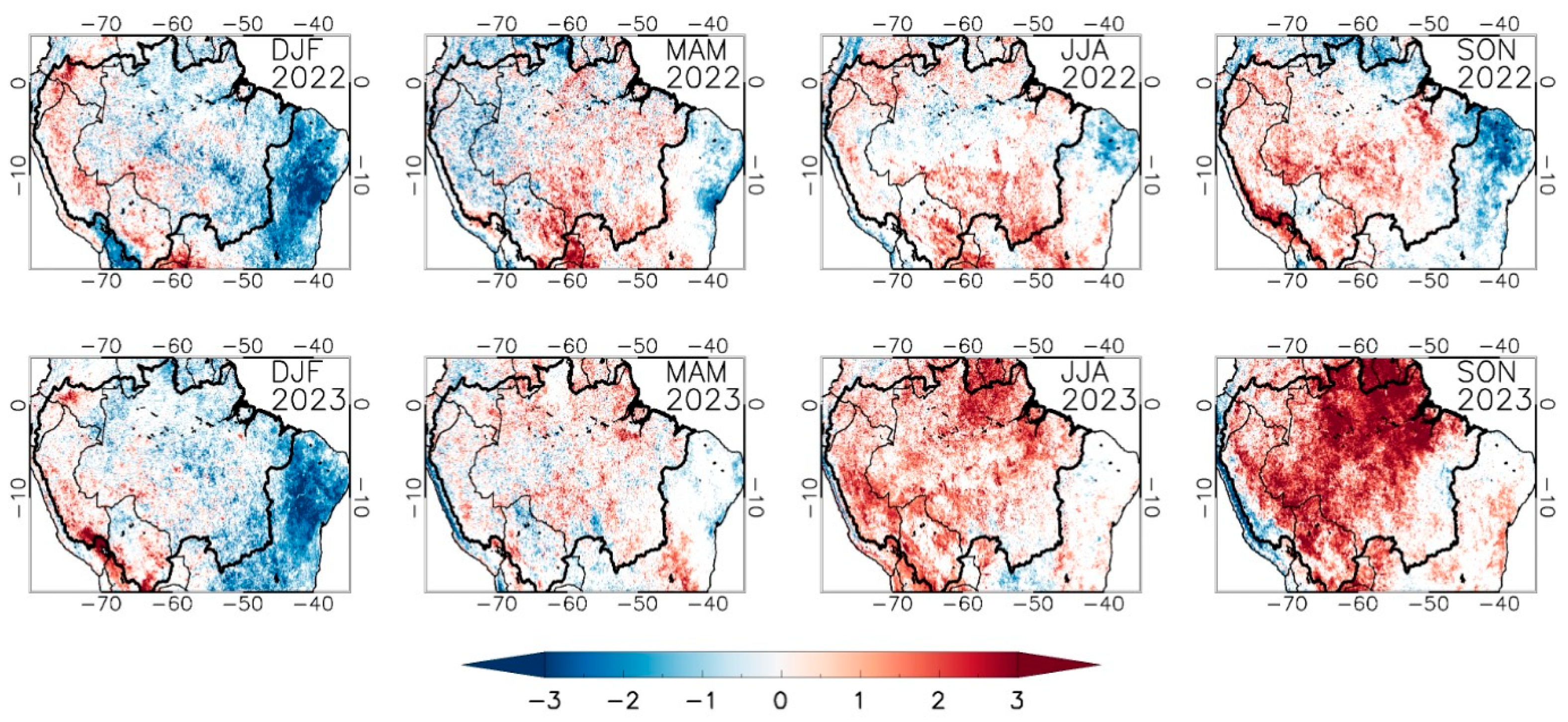
3.1. Land Surface Temperature Anomalies

The Amazon region experienced exceptional positive vegetation temperature anomalies during the second half of the year 2023 (Figure 2). After the cool anomalies evidenced during the austral summer of 2023 (DJF) and the transition to neutral or warm anomalies during the austral autumn (MAM), widespread LST anomalies were observed during the austral winter (JJA) and spring (SON) of 2023. The warm anomalies were especially intense during this last SON season. The spatial patterns of the LST anomalies during the austral summer (DJF) of 2022 and 2023 were similar (with widespread cooling in both cases, except for some western regions in Peru and Bolivia). The rest of the seasons in 2022 (MAM, JJA, and SON) showed progressive warming in most regions of Amazonia, but in 2023, this warming was clear. The southwestern Amazon region was characterized by warm conditions during the austral winter (JJA) and spring (SON) of 2022, particularly marked in the Amazon–Andes transition region in Bolivia and Peru.
In the context of previous severe droughts across Amazonia (e.g., 2005, 2010, and 2016), the LST values typically reached the highest values in September and October 2023, but some differences could be observed between the northern and southern regions (Figure 3). The NW region showed the highest values of temperature in August and September 2023 compared with the other droughts, but the lowest values in January and February 2023. The greatest differences between temperatures in August and October 2023 and the same months in other droughts were observed in the NE region, where the differences were sustained during November and December 2023. This region also showed the lowest values of temperature in January and February 2023. In contrast, the southern regions (SW and SE) showed high temperature values during the second half of the year 2023, but these high values were similar to the values reached during other droughts. In fact, the SE region reached temperature values in August 2023 lower than those obtained during the droughts of 2010 and 2016, and the temperature values in September 2023 were lower than the values obtained during the drought of 2010. These high temperature values can be mostly attributed to El Niño years.
Figure 3 also shows that January (and, to a lesser extent, February) 2016 provided the highest values of vegetation temperature, in concordance with the occurrence of the most recent extreme El Niño event in 2015/16. For 2023, however, El Niño conditions were observed later in the year, mainly since the austral winter [2]. Figure 3 also shows a slightly different seasonality between the four regions.

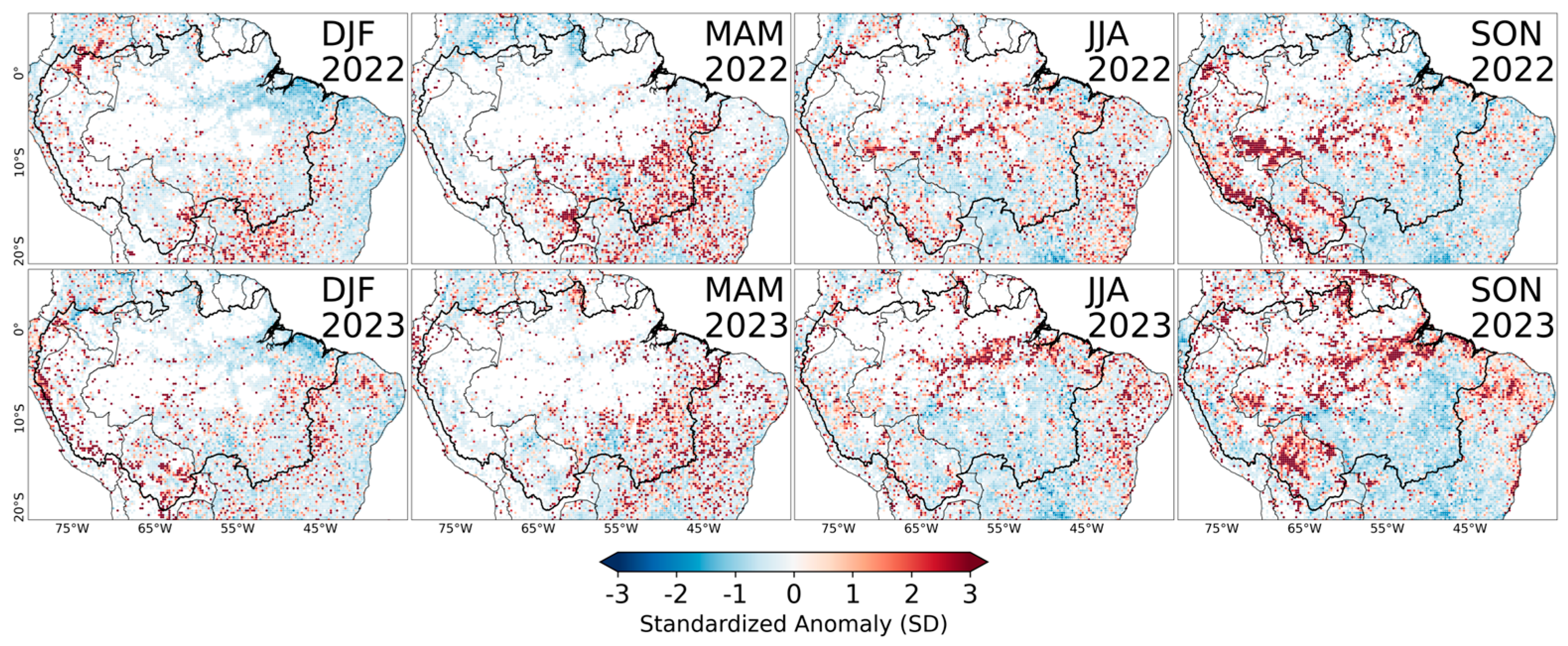
3.2. Amplitude of LST

The spatial patterns of the AMP-LST anomalies were similar to those directly observed in the daytime LST-alone anomalies (Figure 4). This is not surprising since the AMP-LST is highly correlated with the daily maxima temperatures. Nevertheless, the AMP-LST is more closely related to the energy partitioning between the latent and sensible heat flux, since under clear sky conditions, the increase in temperature with respect to the daily minimum depends on (i) the available solar energy and (ii) how efficiently the available energy is used, where lower evaporative fractions lead to higher LST warming rates and, therefore, higher AMP-LST values [40]. During SON 2023, the positive AMP-LST anomalies were focused in the NE region. The positive LST anomalies were also intense in this region and season (Figure 2), but they extended to almost all regions. This different spatial pattern between the LST and AMP-LST anomalies suggests that in large parts of the region of study, the anomalies in the nighttime and daytime LSTs were of the same order, which indicates the evaporative fraction remained high. Because the AMP-LST is a better indicator of water stress conditions than the LST alone, the results in Figure 4 suggest that northern Amazonia (around Roraima, Amapá, and northern Pará) was under water stress conditions during SON 2023. Similarly, water stress predominated across southwestern Amazonia (mainly Bolivia and Peru) during DFJ 2023.
As explained in Section 2.2, the LST and AMP-LST variables were combined to identify regions under heat stress alone or water stress. The results are shown in Figure 5, which reveals that JJA 2023 was characterized by widespread heat stress, and it evolved into water stress across northeastern Amazonia in SON 2023.

3.3. Vegetation Greenness

In synchrony with the LST anomalies shown in Figure 2, vegetation greenness also showed a decrease during the drought of 2023, which was enhanced during the JJA and SON seasons (Figure 6). A decline in greenness was also observed in 2022, but in that year, the greenness anomalies during the SON season were weaker than the anomalies in 2023 for that season. Analogous to the monthly evolution of LST anomalies (Figure 3), the greenness reductions in the northern regions (NE and NW) from September to December were stronger in 2023 than the reductions in other drought events (Figure 7). In the case of the southern regions (SE and SW), the values of the NDVI were below those for the mean reference period, but the lowest values were observed during the 2010 drought.
Figure 7 also illustrates the different greenness values and vegetation phenology across Amazonia, with the northern regions (NE and NW) providing higher (and almost constant) values of the NDVI than the southern regions (SE and SW). These southern regions also showed a minimum peak between August and September, which can be roughly considered the dry season. A contrast between the eastern and western regions was also observed, with higher NDVI values for the western regions than the eastern regions. Because of the different ranges in the NDVI for the different regions, we included in Figure S1 the monthly variations in the NDVI but used an adjusted y-axis range to better visualize the differences between drought events.
Vegetation greenness was also analyzed via the EVI (Figure 8). This index has been traditionally preferred for the analysis of greenness across Amazonia because it is more sensitive than the NDVI in dense vegetation. However, when Figure 6 and Figure 8 are compared, we can extract almost the same conclusions because of the similarity between the NDVI and EVI’s spatial patterns. Nonetheless, negative values of anomalies were less enhanced in the case of the EVI, which could be linked to a saturation of the NDVI in evergreen broadleaf forests.

3.4. Impact of Forest Fires

Figure 9 depicts the evolution of the active fire counts during the different seasons of 2022 and 2023. Overall, the fire season during the DJF and MAM seasons for the last two years occurred under average conditions across most regions of the Amazon basin, but a higher occurrence than average can be observed across the western (DJF season) and southeastern (MAM season) parts of the basin. The fire occurrence across Peru and Bolivia was enhanced in DJF 2023 and across Roraima in MAM 2023. The JJA and SON seasons were characterized by a higher-than-normal fire occurrence across central and northern Amazonia.

4. Discussion

Northern Amazonia experienced record-breaking warming and greenness decline during the austral winter and spring of 2023. Southern Amazonia also experienced anomalous warming and greenness decline, but the anomalous conditions were probably similar to, or even weaker than, the conditions observed during previous droughts.
The canopy temperature and VIs in Amazon forests are subject to seasonal changes related to the transitions from wet to dry and dry to wet seasons [47,48]. In a region of evergreen broadleaf forests, these seasonal changes are typically smooth, with a very small range of variation [49]. However, temperature and greenness anomalies are exacerbated during severe or extreme drought events [50]. The extreme drought events of 2005, 2010, and 2015 observed concurrent warm temperatures [16,51], with the most severe heatwave episodes co-occurring during these years [52] associated with high amounts of incoming solar radiation [16], reductions in cloud cover [53], and soil moisture deficits [23]. These previous droughts peaked in different seasons because they were linked to different climatic episodes. Hence, the droughts in 2005 and 2010 peaked during the dry season, and they were attributed to anomalous SSTs across the Tropical North Atlantic, whereas the 2015–16 drought was attributed to anomalous SSTs across the Tropical Pacific (due to the occurrence of a strong EN event). In a recent review of compound dry–hot episodes across Brazil, Libonati et al. [54] showed that these episodes are increasing in duration and extent across Amazonia. In 2015, almost the entire forest was affected, while during 2005 and 2010, fewer episodes were observed, mainly in the western and southern parts of the biome. This review highlighted that these events enhance land–atmosphere feedback, causing the reamplification of soil dryness and high temperatures, thus culminating in vegetation stress. Most of the previous studies reporting the impacts on forest greenness were focused on the droughts of 2005 and 2010, but recently, Machado-Silva et al. [15] evaluated the responses of temperature and net primary production (NPP) during extreme drought years in the Amazon basin from 2003 to 2020. The authors showed that the forest NPP responded to the coupled impacts of single extreme droughts and the post-drought impacts during ecosystem recovery. Accordingly, they concluded that the NPP consistently decreased during the extreme droughts of 2005, 2010, and 2015 due to the combined effects of disturbances in magnitude and the short length of recovery.
More recently, a few studies reported fluctuations in greenness in Amazon forests during the 2015–16 drought [55,56,57,58]. These studies suggested that negative VI anomalies could be caused by water and heat stress exceeding the tolerance ranges of the rainforest. These results are, to some extent, consistent with the findings presented in this study, in which the negative NDVI (or EVI) anomalies roughly agreed with enhanced positive LST anomalies (heat stress) and positive AMP-LST anomalies (water stress) (see Figure 2, Figure 4 and Figure 5). These maps of anomalies are also consistent with the record temperature values reached during the second half of 2023, especially during the SON 2023 season [2,59]. The results for the ASO season, which was considered a particularly dry season, with an enhanced warming trend, by Gatti et al. [46], do not provide substantially different results from those observed during SON (Figure S2). Drought impacts were still observed in DJF 2024 (Figure S3), as could be expected because of the occurrence of an intense El Niño event in 2023/2024 [2,3].
As commented in the Introduction Section, the use of the NDVI/EVI in previous studies of greenness analysis in Amazon forests was controversial because of the impacts of clouds on previous versions of MODIS products. In this study, the latest version 6.1 was used, which has been proven to provide satisfactory results compared with other cloud mask schemes [60,61]. The NDVI extracted from the MANVI product was also considered, which uses improved cloud masking and atmospheric correction [62]. Although a dedicated comparison between the MODIS and MANVI products was outside the scope of this paper, a preliminary comparison in terms of the NDVI showed a consistent spatial pattern between them (Figure S4). Future analysis of these drought impacts based on field data will provide a better interpretation of the behaviors of these parameters.
Fire activity is linked to high temperatures, low relative humidity, and precipitation, which modulate vegetation stress and fuel levels [63]. The role of the climate, especially during extreme droughts, has been shown to exacerbate the fire incidence, intensity, and severity in the Amazon forest [64]. The spatial coherence of hot and dry conditions with higher fire occurrences is shown in all the results, and previous analyses of the region corroborate this. However, it is worth noting that the response of Amazon fire activity to severe droughts is, in turn, constrained by land-use changes, in particular, deforestation, which may also affect precipitation and temperature patterns [38,65,66]. As demonstrated by Libonati et al. [21], from a climate perspective, the 2015 drought was the most extreme of the three major drought events of 2005, 2010, and 2015. However, when evaluated from a fire pattern perspective, the response of the Amazon forest to the 2015 drought resulted in a relatively low level of fire activity compared with the two previous severe droughts due to low deforestation rates. The role played by anthropogenic activities in fire incidence is beyond the scope of this work, but the need for further analysis, taking into account not only this but also other factors that may contribute to fire behavior across the Amazon forest besides climate extremes, is reinforced.

5. Conclusions

Recent studies reported record-breaking temperatures and drought across Amazonia in 2023 based mainly on hydrometeorological and reanalysis data [2,3]. This paper provides a complementary assessment based on independent remotely sensed data. The remote-sensing products used in this study are based on spectral acquisitions from the VNIR and TIR regions, thus providing information on the vegetation status and temperature, respectively. In spite of the limitations of using optical remote-sensing datasets for the study of the Amazon, when working at monthly and seasonal levels, these datasets are useful to obtain a general picture of the characteristics, evolution, and impacts of drought on vegetation at the basin level.
The spatial overview provided in this study is particularly relevant considering that the southern part of the Amazon basin is already undergoing a biophysical transition, characterized by a lengthening dry season and increased tree mortality and fire activity [67,68,69,70]. Our results confirm that during 2022–2023, water stress and significantly warm conditions were dominant during SON, which corresponds to the climatological dry-to-wet transition season in southern Amazonia. These results are in line with future projections for temperature and precipitation across southern Amazonia, where a warmer and delayed onset of the wet season is projected as a consequence of global climate change and Amazon deforestation [71,72,73,74,75,76].
Given the importance of the Amazon forest and the extreme drought–heat event of 2023, we encourage future studies to provide further insights into the regional hydrological impacts, including on the Andes–Amazon–Atlantic hydroclimatic system [77], and ecological impacts on this biome.

Supplementary Materials

The following supporting information can be downloaded at https://www.mdpi.com/article/10.3390/rs16142519/s1, Figure S1: Monthly values of NDVI for years of occurrence of some of the most recent severe droughts across Amazonia, including the drought of 2023. Results are provided for NW, NE, and SW regions using a stretched y-axis range for better visualization of the differences between years. The climatological mean (2003–2020) is also included; Figure S2: Maps of land surface temperature (LST), normalized difference vegetation index (NDVI), and enhanced vegetation index (EVI) standardized anomalies for ASO season during 2022 and 2023; Figure S3: Maps of land surface temperature (LST), normalized difference vegetation index (NDVI), and enhanced vegetation index (EVI) standardized anomalies for DJF season in 2024; Figure S4: Maps of normalized difference vegetation index (NDVI) standardized anomalies for two illustrative years (2010 and 2021) using MODIS (left) and MANVI (right) products.

Author Contributions

Conceptualization, J.C.J.; methodology, J.C.J., V.M., I.T. and R.L.; formal analysis, J.C.J., V.M., I.T., R.L., L.F.P., J.-C.E. and J.A.M.; data curation, J.C.J., V.M. and R.A.; writing—original draft preparation, J.C.J., V.M. and I.T.; writing—review and editing, all authors. All authors have read and agreed to the published version of the manuscript.

Funding

This research received no external funding.

Data Availability Statement

The MODIS datasets used in this study are publicly available at NASA’s Earth Data Search portal (https://search.earthdata.nasa.gov/search, accessed on 26 April 2024). The derived products, such as the anomalies and maps, are available from the authors upon request.

Acknowledgments

We acknowledge the MODIS project for providing the scientific community with the different land products used in this study.

Conflicts of Interest

The authors declare no conflicts of interest.

References

  1. Perkins-Kirkpatrick, S.; Barriopedro, D.; Jha, R.; Wang, L.; Mondal, A.; Libonati, R.; Kornhuber, K. Extreme terrestrial heat in 2023. Nat. Rev. Earth Environ. 2024, 5, 244–246. [Google Scholar] [CrossRef]
  2. Espinoza, J.C.; Jimenez, J.C.; Marengo, J.A.; Schongart, J.; Ronchail, J.; Lavado-Casimiro, W.; Ribeiro, J.R.M. The new record of drought and warmth in the Amazon in 2023 related to regional and global climatic features. Sci. Rep. 2024, 14, 8107. [Google Scholar] [CrossRef] [PubMed]
  3. Marengo, J.A.; Cunha, A.P.; Espinoza, J.C.; Fu, R.; Schongart, J.; Jimenez, J.C.; Costa, M.C.; Ribeiro, J.M.; Wongchuig, S.; Zhao, S. Extremes of hydrometeorology and dry season length in Amazonia associated with the drought of 2023. Am. J. Clim. Chang. 2024, under review. [Google Scholar]
  4. Rodrigues, M. The Amazon’s record-setting drought: How bad will it be? Nature 2023, 623, 675–676. [Google Scholar] [CrossRef]
  5. Clarke, B.; Barnes, C.; Rodrigues, R.; Zachariah, M.; Stewart, S.; Raju, E.; Baumgart, N.; Heinrich, D.; Libonati, R.; Santos, D.; et al. Climate Change, Not El Niño, Main Driver of Exceptional Drought in Highly Vulnerable Amazon River Basin. Available online: https://spiral.imperial.ac.uk/handle/10044/1/108761 (accessed on 21 May 2024).
  6. Van Lanen, H.A.J.; Vogt, J.V.; Andreu, J.; Carrão, H.; De Stefano, L.; Dutra, E.; Feyen, L.; Forzieri, G.; Hayes, M.; Iglesias, A.; et al. Climatological risk: Droughts. In Science for Disaster Risk Management 2017: Knowing Better and Losing Less; Poljanšek, K., Marín Ferrer, M., De Groeve, T., Clark, I., Eds.; EUR 28034 EN; Publications Office of the European Union: Luxembourg, 2017; Chapter 3.9. [Google Scholar] [CrossRef]
  7. Asner, G.P.; Alencar, A. Drought impacts on the amazon forest: The remote sensing perspective. New Phytol. 2010, 187, 569–578. [Google Scholar] [CrossRef] [PubMed]
  8. Anderson, L.O.; Malhi, Y.; Aragão, L.E.O.C.; Ladle, R.; Arai, E.; Barbier, N.; Phillips, O. Remote sensing detection of droughts in Amazonian forest canopies. New Phytol. 2010, 187, 733–750. [Google Scholar] [CrossRef] [PubMed]
  9. Anderson, L.O.; Ribeiro Neto, G.; Cunha, A.P.; Fonseca, M.G.; Mendes de Moura, Y.; Dalagnol, R.; Wagner, F.H.; de Aragão, L.E.O.E.C. Vulnerability of amazonian forests to repeated droughts. Philos. Trans. R. Soc. B Biol. Sci. 2018, 373, 20170411. [Google Scholar] [CrossRef]
  10. Paredes-Trejo, F.; Barbosa, H.A.; Giovannettone, J.; Lakshmi Kumar, T.V.; Thakur, M.K.; de Oliveira Buriti, C. Long-Term Spatiotemporal Variation of Droughts in the Amazon River Basin. Water 2021, 13, 351. [Google Scholar] [CrossRef]
  11. Zhao, W.; Zhao, X.; Zhou, T.; Wu, D.; Tang, B.; Wei, H. Climatic factors driving vegetation declines in the 2005 and 2010 Amazon droughts. PLoS ONE 2017, 12, e0175379. [Google Scholar] [CrossRef]
  12. Samanta, A.; Ganguly, S.; Vermote, E.; Nemani, R.R.; Myneni, R.B. Interpretation of variations in MODIS-measured greenness levels of Amazon forests during 2000 to 2009. Environ. Res. Lett. 2012, 7, 024018. [Google Scholar] [CrossRef]
  13. Xu, L.; Samanta, A.; Costa, M.H.; Ganguly, S.; Nemani, R.R.; Myneni, R.B. Widespread decline in greenness of Amazonian vegetation due to the 2010 drought. Geophys. Res. Lett. 2011, 38, L07402. [Google Scholar] [CrossRef]
  14. Samanta, A.; Ganguly, S.; Hashimoto, H.; Devadiga, S.; Vermote, E.; Knyazikhin, Y.; Nemani, R.R.; Myneni, R.B. Amazon forests did not green-up during the 2005 drought. Geophys. Res. Lett. 2010, 37, L05401. [Google Scholar] [CrossRef]
  15. Machado-Silva, F.; Peres, L.F.; Gouveia, C.M.; Enrich-Prast, A.; Peixoto, R.B.; Pereira, J.M.C.; Marotta, H.; Fernandes, P.J.F.; Libonati, R. Drought resilience debt drives NPP decline in the Amazon forest. Glob. Biogeochem. Cycles 2021, 35, e2021GB007004. [Google Scholar] [CrossRef]
  16. Panisset, J.S.; Libonati, R.; Gouveia, C.M.P.; Machado-Silva, F.; França, D.A.; França, J.R.A.; Peres, L.F. Contrasting patterns of the extreme drought episodes of 2005, 2010 and 2015 in the Amazon Basin. Int. J. Climatol. 2018, 38, 1096–1104. [Google Scholar] [CrossRef]
  17. Jiménez-Muñoz, J.C.; Sobrino, J.A.; Mattar, C.; Malhi, Y. Spatial and temporal patterns of the recent warming of the Amazon forest. J. Geophys. Res. Atmos. 2013, 118, 5204–5215. [Google Scholar] [CrossRef]
  18. Toomey, M.; Roberts, D.A.; Still, C.; Goulden, M.L.; McFadden, J.P. Remotely sensed heat anomalies linked with Amazonian forest biomass declines. Geophys. Res. Lett. 2011, 38, L19704. [Google Scholar] [CrossRef]
  19. Liu, S.; McVicar, T.R.; Wu, X.; Cao, X.; Liu, Y. Assessing the relative importance of dry-season incoming solar radiation and water storage dynamics during the 2005, 2010 and 2015 southern Amazon droughts: Not all droughts are created equal. Environ. Res. Lett. 2024, 19, 034027. [Google Scholar] [CrossRef]
  20. Cano-Crespo, A.; Traxl, D.; Thonicke, K. Spatio-temporal patterns of extreme fires in Amazonian forests. Eur. Phys. J. Spec. Top. 2021, 230, 3033–3044. [Google Scholar] [CrossRef]
  21. Libonati, R.; Pereira, J.M.C.; Da Camara, C.C.; Peres, L.F.; Oom, D.; Rodrigues, J.A.; Santos, F.L.M.; Trigo, R.M.; Gouveia, C.M.P.; Machado-Silva, F.; et al. Twenty-first century droughts have not increasingly exacerbated fire season severity in the Brazilian Amazon. Sci. Rep. 2021, 11, 4400. [Google Scholar] [CrossRef] [PubMed]
  22. Albert, J.; Hoorn, C.; Malhi, Y.; Phillips, O.; Encalada, A.C.; ter Steege, H.; Melack, J.; Trumbore, S.E.; Hecht, S.; Varese, M.; et al. The Multiple Viewpoints for the Amazon: Geographic Limits and Meanings. Available online: https://www.theamazonwewant.org/wp-content/uploads/2021/09/220105_The-multiple-viewpoints-for-the-Amazon-formatted-and-reviewed-050122.pdf (accessed on 21 May 2024).
  23. Garcia, B.N.; Libonati, R.; Nunes, A.M.B. Extreme drought events over the Amazon Basin: The perspective from the reconstruction of South American hydroclimate. Water 2018, 10, 1594. [Google Scholar] [CrossRef]
  24. Builes-Jaramillo, A.; Poveda, G. Conjoint analysis of surface and atmospheric water balances in the Andes-Amazon system. Water Resour. Res. 2018, 54, 3472–3489. [Google Scholar] [CrossRef]
  25. Moura, M.M.; dos Santos, A.R.; Pezzopane, J.E.M.; Alexandre, R.S.; da Silva, S.F.; Pimentel, S.M.; de Carvalho, J.R. Relation of el niño and la niña phenomena to precipitation, evapotranspiration and temperature in the amazon basin. Sci. Total Environ. 2019, 651, 1639–1651. [Google Scholar] [CrossRef]
  26. Zhou, J.; Lau, K. Does a Monsoon Climate Exist over South America? J. Clim. 1998, 11, 1020–1040. [Google Scholar] [CrossRef]
  27. Kodama, Y. Large-scale common features of subtropical precipitation zones (the baiu frontal zone, the SPCZ, and the SACZ) part I: Characteristics of subtropical frontal zones. J. Meteorol. Soc. Japan. Ser. II 1992, 70, 813–836. [Google Scholar] [CrossRef]
  28. Kodama, Y. Large-scale common features of sub-tropical convergence zones (the baiu frontal zone, the SPCZ, and the SACZ) part II: Conditions of the circulations for generating the STCZs. J. Meteorol. Soc. Japan. Ser. II 1993, 71, 581–610. [Google Scholar] [CrossRef]
  29. Montini, T.L.; Jones, C.; Carvalho, L.M.V. The South American low-level jet: A new climatology, variability, and changes. J. Geophys. Res. Atmos. 2019, 124, 1200–1218. [Google Scholar] [CrossRef]
  30. Byrne, M.P.; Pendergrass, A.G.; Rapp, A.D.; Wodzicki, K.R. Response of the Intertropical Convergence Zone to Climate Change: Location, Width, and Strength. Curr. Clim. Chang. Rep. 2018, 4, 355–370. [Google Scholar] [CrossRef] [PubMed]
  31. Paca, V.H.d.M.; Espinoza-Dávalos, G.E.; Moreira, D.M.; Comair, G. Variability of Trends in Precipitation across the Amazon River Basin Determined from the CHIRPS Precipitation Product and from Station Records. Water 2020, 12, 1244. [Google Scholar] [CrossRef]
  32. Espinoza, J.C.; Ronchail, J.; Guyot, J.L.; Cochonneau, G.; Naziano, F.; Lavado, W.; De Olivera, E.; Pombosa, R.; Vauchel, P. Spatio—Temporal rainfall variability in the Amazon Basin Countries (Brazil, Peru, Bolivia, Colombia and Ecuador). Int. J. Climatol. 2009, 29, 1574–1594. [Google Scholar] [CrossRef]
  33. Vilanova, R.S.; Delgado, R.C.; Frossard de Andrade, C.; Lopes dos Santos, G.; Magistrali, I.C.; Moreira de Oliveira, C.M.; Teodoro, P.E.; Capristo Silva, G.F.; Silva Junior, C.A.d.; de Ávila Rodrigues, R. Vegetation degradation in ENSO events: Drought assessment, soil use and vegetation evapotranspiration in the western brazilian amazon. Remote Sens. Appl. Soc. Environ. 2021, 23, 100531. [Google Scholar] [CrossRef]
  34. Moon, M.; Zhang, X.; Henebry, G.M.; Liu, L.; Gray, J.M.; Melaas, E.K.; Friedl, M.A. Long-term continuity in land surface phenology measurements: A comparative assessment of the MODIS land cover dynamics and VIIRS land surface phenology products. Remote Sens. Environ. 2019, 226, 74–92. [Google Scholar] [CrossRef]
  35. Wan, Z. New refinements and validation of the collection-6 MODIS land-surface temperature/emissivity product. Remote Sens. Environ. 2014, 140, 36–45. [Google Scholar] [CrossRef]
  36. De Oliveira, G.; Brunsell, N.A.; Moraes, E.C.; Bertani, G.; Dos Santos, T.V.; Shimabukuro, Y.E.; Aragão, L.E.O.C. Use of MODIS Sensor Images Combined with Reanalysis Products to Retrieve Net Radiation in Amazonia. Sensors 2016, 16, 956. [Google Scholar] [CrossRef] [PubMed]
  37. Waring, A.M.; Ghent, D.; Perry, M.; Anand, J.S.; Veal, K.L.; Remedios, J. Regional climate trend analyses for Aqua MODIS land surface temperatures. Int. J. Remote Sens. 2023, 44, 4989–5032. [Google Scholar] [CrossRef]
  38. Vargas Zeppetello, L.R.; Parsons, L.A.; Spector, J.T.; Naylor, R.L.; Battisti, D.S.; Masuda, Y.J.; Wolff, N.H. Large scale tropical deforestation drives extreme warming. Environ. Res. Lett. 2020, 15, 084012. [Google Scholar] [CrossRef]
  39. Gomis-Cebolla, J.; Jimenez, J.C.; Sobrino, J.A. LST retrieval algorithm adapted to the amazon evergreen forests using MODIS data. Remote Sens. Environ. 2018, 204, 401–411. [Google Scholar] [CrossRef]
  40. Miranda, V.F.V.V.; Jimenez, J.C.; Dutra, E.; Trigo, I.F. Consistency assessment of latent heat flux and observational datasets over the amazon basin. Environ. Res. Lett. 2024, 19, 054044. [Google Scholar] [CrossRef]
  41. Huete, A.; Didan, K.; van Leeuwen, W.; Miura, T.; Glenn, E. MODIS vegetation indices. In Land Remote Sensing and Global Environmental Change; Springer: New York, NY, USA, 2010; pp. 579–602. [Google Scholar]
  42. Tucker, C.J. Red and photographic infrared linear combinations for monitoring vegetation. Remote Sens. Environ. 1979, 8, 127–150. [Google Scholar] [CrossRef]
  43. Giglio, L.; Schroeder, W.; Justice, C.O. The collection 6 MODIS active fire detection algorithm and fire products. Remote Sens. Environ. 2016, 178, 31–41. [Google Scholar] [CrossRef]
  44. Sulla-Menashe, D.; Gray, J.M.; Abercrombie, S.P.; Friedl, M.A. Hierarchical mapping of annual global land cover 2001 to present: The MODIS collection 6 land cover product. Remote Sens. Environ. 2019, 222, 183–194. [Google Scholar] [CrossRef]
  45. Lee, J.; Wong, D.W.S. Statistical Analysis with ArcView GIS; John Wiley and Sons, Inc.: Hoboken, NJ, USA, 2001. [Google Scholar]
  46. Gatti, L.V.; Basso, L.S.; Miller, J.B.; Gloor, M.; Gatti Domingues, L.; Cassol, H.L.; Tejada, G.; Aragão, L.E.; Nobre, C.; Peters, W.; et al. Amazonia as a carbon source linked to deforestation and climate change. Nature 2021, 595, 388–393. [Google Scholar] [CrossRef] [PubMed]
  47. Baker, I.T.; Harper, A.B.; da Rocha, H.R.; Denning, A.S.; Araújo, A.C.; Borma, L.S.; Freitas, H.C.; Goulden, M.L.; Manzi, A.O.; Miller, S.D.; et al. Surface ecophysiological behavior across vegetation and moisture gradients in tropical south america. Agric. For. Meteorol. 2013, 182–183, 177–188. [Google Scholar] [CrossRef]
  48. Bela, M.M.; Longo, K.M.; Freitas, S.R.; Moreira, D.S.; Beck, V.; Wofsy, S.C.; Gerbig, C.; Wiedemann, K.; Andreae, M.O.; Artaxo, P. Ozone production and transport over the Amazon Basin during the dry-to-wet and wet-to-dry transition seasons. Atmos. Chem. Phys. 2015, 15, 757–782. [Google Scholar] [CrossRef]
  49. Zhang, Q.; Xiao, X.; Braswell, B.; Linder, E.; Ollinger, S.; Smith, M.; Jenkins, J.P.; Baret, F.; Richardson, A.D.; More III, B.; et al. Characterization of seasonal variation of forest canopy in a temperate deciduous broadleaf forest, using daily MODIS data. Remote Sens. Environ. 2006, 105, 189–203. [Google Scholar] [CrossRef]
  50. Liu, L.; Gudmundsson, L.; Hauser, M.; Qin, D.; Li, S.; Seneviratne, S.I. Soil moisture dominates dryness stress on ecosystem production globally. Nat. Commun. 2020, 11, 4892. [Google Scholar] [CrossRef] [PubMed]
  51. Jiménez-Muñoz, J.C.; Mattar, C.; Barichivich, J.; Santamaría-Artigas, A.; Takahashi, K.; Sobrino, J.A.; Malhi, Y.; Schrier, G.v.d. Record-breaking warming and extreme drought in the amazon rainforest during the course of el niño 2015–2016. Sci. Rep. 2016, 6, 33130. [Google Scholar] [CrossRef] [PubMed]
  52. Costa, D.F.; Gomes, H.B.; Silva, M.C.L.; Zhou, L. The most extreme heat waves in Amazonia happened under extreme dryness. Clim. Dyn. 2022, 59, 1–15. [Google Scholar] [CrossRef]
  53. Jimenez, J.C.; Libonati, R.; Peres, L.F. Droughts Over Amazonia in 2005, 2010, and 2015: A Cloud Cover Perspective. Front. Earth Sci. 2018, 6, 227. [Google Scholar] [CrossRef]
  54. Libonati, R.; Geirinhas, J.L.; Silva, P.S.; Monteiro dos Santos, D.; Rodrigues, J.A.; Russo, A.; Peres, L.F.; Narcizo, L.; Gomes, M.E.R.; Rodrigues, A.P.; et al. Drought–heatwave nexus in Brazil and related impacts on health and fires: A comprehensive review. Ann. N. Y. Acad. Sci. 2022, 1517, 44–62. [Google Scholar] [CrossRef]
  55. Liu, Y.Y.; van Dijk, A.I.J.M.; Meir, P.; McVicar, T.R. Drought and radiation explain fluctuations in Amazon rainforest greenness during the 2015–2016 drought. Biogeosciences 2024, 21, 2273–2295. [Google Scholar] [CrossRef]
  56. She, X.; Li, Y.; Jiao, W.; Sun, Y.; Ni, X.; Zuo, Z.; Knyazikhin, Y.; Myneni, R.B. Varied responses of amazon forests to the 2005, 2010, and 2015/2016 droughts inferred from multi-source satellite data. Agric. For. Meteorol. 2024, 353, 110051. [Google Scholar] [CrossRef]
  57. Fonseca, L.D.M.; Dalagnol, R.; Malhi, Y.; Rifai, S.W.; Costa, G.B.; Silva, T.S.F.; Da Rocha, H.R.; Tavares, I.B.; Borma, L.S. Phenology and Seasonal Ecosystem Productivity in an Amazonian Floodplain Forest. Remote Sens. 2019, 11, 1530. [Google Scholar] [CrossRef]
  58. Yang, J.; Tian, H.; Pan, S.; Chen, G.; Zhang, B.; Dangal, S. Amazon drought and forest response: Largely reduced forest photosynthesis but slightly increased canopy greenness during the extreme drought of 2015/2016. Glob. Chang. Biol. 2018, 24, 1919–1934. [Google Scholar] [CrossRef] [PubMed]
  59. World Meteorological Organization (WMO). State of the Climate in Latin America and the Caribbean 2023, WMO-No. 1351, Geneva, Switzerland. 2024. Available online: https://library.wmo.int/idurl/4/68891 (accessed on 27 June 2024).
  60. Morton, D.; Nagol, J.; Carabajal, C.; Rosette, J.; Palace, M.; Cook, B.D.; Vermote, E.F.; Harding, D.J.; North, P.R. Amazon forests maintain consistent canopy structure and greenness during the dry season. Nature 2014, 506, 221–224. [Google Scholar] [CrossRef] [PubMed]
  61. Hilker, T.; Lyapustin, A.I.; Tucker, C.J.; Sellers, P.J.; Hall, F.G.; Wang, Y. Remote sensing of tropical ecosystems: Atmospheric correction and cloud masking matter. Remote Sens. Environ. 2012, 127, 370–384. [Google Scholar] [CrossRef]
  62. Dalagnol, R.; Wagner, F.H.; Galvão, L.S.; Aragão, L.E.O.C. The MANVI product: MODIS (MAIAC) nadir-solar adjusted vegetation indices (EVI and NDVI) for South America (Versión v1) [Data set]. Zenodo 2019, 10, 5281. [Google Scholar] [CrossRef]
  63. Jolly, W.M.; Cochrane, M.A.; Freeborn, P.H.; Holden, Z.A.; Brown, T.J.; Williamson, G.J.; Bowman, D.M.J.S. Climate-induced variations in global wildfire danger from 1979 to 2013. Nat. Commun. 2015, 6, 7537. [Google Scholar] [CrossRef]
  64. Chen, Y.; Morton, D.; Andela, N.; Werf, G.; Giglio, L.; Randerson, J. A pan-tropical cascade of fire driven by El Niño/Southern Oscillation. Nat. Clim. Chang. 2017, 7, 906–911. [Google Scholar] [CrossRef]
  65. Moreira, R.M.; dos Santos, B.C.; Biggs, T.; de Sales, F.; Sieber, S. Identifying clusters of precipitation for the Brazilian Legal Amazon based on magnitude of trends and its correlation with sea surface temperature. Sci. Rep. 2024, 14, 14067. [Google Scholar] [CrossRef]
  66. Butt, E.W.; Baker, J.C.A.; Bezerra, F.G.S.; von Randow, C.; Aguiar, A.P.D.; Spracklen, D.V. Amazon deforestation causes strong regional warming. Proc. Natl. Acad. Sci. USA 2023, 120, e2309123120. [Google Scholar] [CrossRef]
  67. Arias, P.A.; Fu, R.; Vera, C.S.; Rojas, M. A correlated shortening of the North and South American monsoon seasons in the past few decades. Clim. Dyn. 2015, 45, 3183–3203. [Google Scholar] [CrossRef]
  68. Espinoza, J.C.; Arias, P.A.; Moron, V.; Junquas, C.; Segura, H.; Sierra-Perez, J.; Wongchuig, S.; Condom, T. Recent changes in the atmospheric circulation patterns during the dry-to-wet transition season in south tropical South America (1979–2020): Impacts on precipitation and fire season. J. Clim. 2021, 34, 9025–9042. [Google Scholar] [CrossRef]
  69. Brienen, R.J.W.; Phillips, O.L.; Feldpausch, T.R.; Gloor, E.; Baker, T.R.; Lloyd, J.; Lopez-Gonzalez, G.; Monteagudo-Mendoza, A.; Malhi, Y.; Lewis, S.L.; et al. Long-term decline of the Amazon carbon sink. Nature 2015, 519, 344–348. [Google Scholar] [CrossRef] [PubMed]
  70. Chen, S.; Stark, S.C.; Nobre, A.D.; Cuartas, L.A.; Amore, D.J.; Restrepo-Coupe, N.; Smith, M.N.; Chitra-Tarak, R.; Ko, H.; Nelson, B.W.; et al. Amazon forest biogeography predicts resilience and vulnerability to drought. Nature 2024, 631, 111–117. [Google Scholar] [CrossRef] [PubMed]
  71. Parsons, L.A. Implications of CMIP6 projected drying trends for 21st century Amazonian drought risk. Earth’s Future 2020, 8, e2020EF001608. [Google Scholar] [CrossRef]
  72. Agudelo, J.; Espinoza, J.C.; Junquas, C.; Arias, P.A.; Sierra, J.P.; Olmo, M.E. Future projections of low-level atmospheric circulation patterns over South Tropical South America: Impacts on precipitation and Amazon dry season length. J. Geophys. Res. Atmos. 2023, 128, e2023JD038658. [Google Scholar] [CrossRef]
  73. Bottino, M.J.; Nobre, P.; Giarolla, E.; da Silva Junior, M.B.; Capistrano, V.B.; Malagutti, M.; Tamaoki, J.N.; Alves de Oliveira, B.F.; Nobre, C.A. Amazon savannization and climate change are projected to increase dry season length and temperature extremes over brazil. Sci. Rep. 2024, 14, 5131. [Google Scholar] [CrossRef]
  74. Baker, J.C.A.; Garcia-Carreras, L.; Buermann, W.; Castilho de Souza, D.; Marsham, J.H.; Kubota, P.Y.; Gloor, M.; Coelho, C.A.S.; Spracklen, D.V. Robust amazon precipitation projections in climate models that capture realistic land–atmosphere interactions. Environ. Res. Lett. 2021, 16, 074002. [Google Scholar] [CrossRef]
  75. Commar, L.F.S.; Abrahão, G.M.; Costa, M.H. A possible deforestation-induced synoptic-scale circulation that delays the rainy season onset in amazonia. Environ. Res. Lett. 2023, 18, 044041. [Google Scholar] [CrossRef]
  76. Eiras-Barca, J.; Dominguez, F.; Yang, Z.; Chug, D.; Nieto, R.; Gimeno, L.; Miguez-Macho, G. Changes in south american hydroclimate under projected amazonian deforestation. Ann. N. Y. Acad. Sci. 2020, 1472, 104–122. [Google Scholar] [CrossRef]
  77. Beveridge, C.F.; Espinoza, J.C.; Athayde, S.; Correa, S.B.; Couto, T.B.A.; Heilpern, S.A.; Jenkins, C.N.; Piland, N.C.; Utsunomiya, R.; Wongchuig, S.; et al. The Andes–Amazon–Atlantic pathway: A foundational hydroclimate system for social–ecological system sustainability. Proc. Natl. Acad. Sci. USA 2024, 121, e2306229121. [Google Scholar] [CrossRef] [PubMed]
Figure 1. Land cover of the study area. The thick black line delineates the Amazon River basin, including the Tocantins–Araguaia drainage basin. Grey thin lines indicate the country’s borders. The study area is arbitrarily divided into four quarters (black lines): Northeast (NE), Northwest (NW), Southwest (SW), and Southeast (SE). Five different land-cover classes are visualized: evergreen broadleaf forests (EBF), deciduous broadleaf forests (DBF), savannas and woody savannas (SAV), grasslands (GRA), and croplands (CRO). Brazilian states within the Amazon basin are also labeled: AM (Amazonas), RR (Roraima), AP (Amapá), PA (Pará), MA (Maranhão), TO (Tocantins), CO (Goiás), MT (Matto Grosso), RO (Rondônia), and AC (Acre).
Remotesensing 16 02519 g001
Figure 2. Maps of land surface temperature (LST) standardized anomalies for DJF, MAM, JJA, and SON seasons during 2022 and 2023.
Remotesensing 16 02519 g002
Figure 3. Monthly values of land surface temperature (LST) for years of occurrence of some of the most recent severe droughts across Amazonia, including the drought of 2023. Results are provided for the four quarters delimiting the north–east and west–east regions (NW, NE, SW, and SE). The climatological mean (2003–2020) is also included.
Remotesensing 16 02519 g003
Figure 4. Maps of amplitude of land surface temperature (AMP-LST) standardized anomalies for DJF, MAM, JJA, and SON seasons during 2022 and 2023.
Remotesensing 16 02519 g004
Figure 5. Maps based on classification via the combination of LST (Figure 2) and AMP-LST (Figure 4) standardized anomalies. Regions colored in red can be interpreted as water-stressed, whereas regions colored in orange can be interpreted as heat-stressed.
Remotesensing 16 02519 g005
Figure 6. Maps of normalized difference vegetation index (NDVI) standardized anomalies for DJF, MAM, JJA, and SON seasons during 2022 and 2023.
Remotesensing 16 02519 g006
Figure 7. Monthly values of normalized difference vegetation index (NDVI) for years of occurrence of some of the most recent severe droughts across Amazonia, including the drought of 2023. Results are provided for the four quarters delimiting the north–east and west–east regions (NW, NE, SW, and SE). The climatological mean (2003–2020) is also included.
Remotesensing 16 02519 g007
Figure 8. Maps of enhanced vegetation index (EVI) standardized anomalies for DJF, MAM, JJA, and SON seasons during 2022 and 2023.
Remotesensing 16 02519 g008
Figure 9. Maps of active fire counts standardized anomalies in 0.25° cells for DJF, MAM, JJA, and SON seasons during 2022 and 2023.
Remotesensing 16 02519 g009
Disclaimer/Publisher’s Note: The statements, opinions and data contained in all publications are solely those of the individual author(s) and contributor(s) and not of MDPI and/or the editor(s). MDPI and/or the editor(s) disclaim responsibility for any injury to people or property resulting from any ideas, methods, instructions or products referred to in the content.

