
Current Status of Remote Sensing for Studying the Impacts of Hurricanes on Mangrove Forests in the Coastal United States

 ,
,  , , ,
, , ,  , , ,
, , ,  and
and 
Abstract
1. Introduction
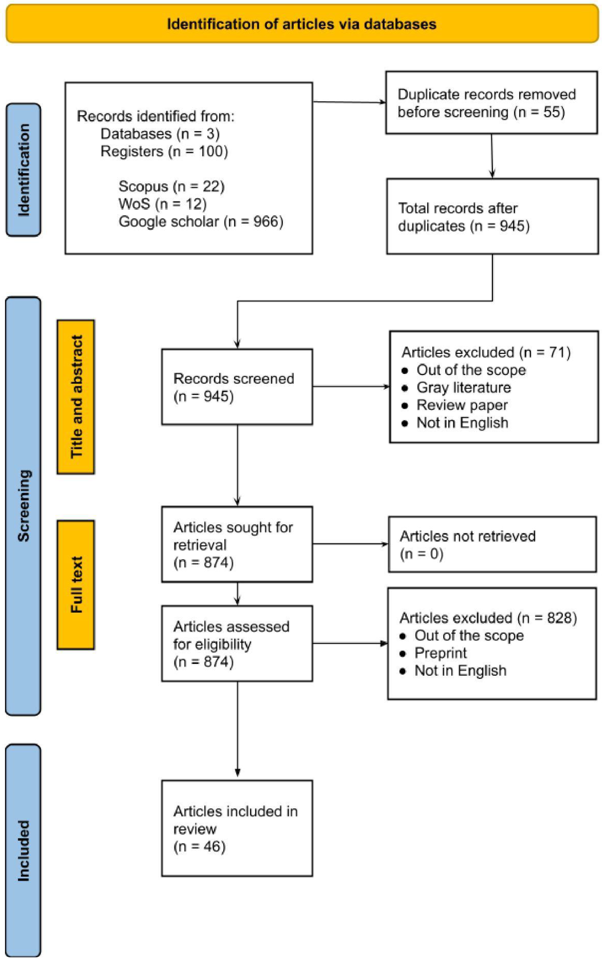
2. Methods
3. Applications of Remote Sensing
3.1. Remote Sensing Data Sources for Studying Mangroves
3.2. Data and Methods Used for Assessing Hurricane Damage in Coastal United States
3.3. Technical Applications of Remote Sensing
3.3.1. Damage Detection and Change Assessment
3.3.2. Monitoring Regrowth, Recovery and Resilience
3.3.3. Structural and 3D Analysis
3.3.4. Spatial and Temporal Variability
3.3.5. Risk Modeling and Assessment
3.3.6. Biomass and Carbon Dynamics
3.4. Impacts of Hurricanes on Mangrove Forests and Coastal Communities Studied Using Remote Sensing
3.4.1. Climate Change and Environmental Stressors
3.4.2. Conservation and Management
3.4.3. Impacts on Coastal Areas and Communities
3.4.4. Anthropogenic Disturbances
3.4.5. Resilience Provided by Mangroves
3.4.6. Indirect Impacts
4. Concluding Remarks
Author Contributions
Funding
Data Availability Statement
Acknowledgments
Conflicts of Interest
References
- Garner, A.J. Observed Increases in North Atlantic Tropical Cyclone Peak Intensification Rates. Sci. Rep. 2023, 13, 16299. [Google Scholar] [CrossRef]
- Taillie, P.J.; Roman-Cuesta, R.; Lagomasino, D.; Cifuentes-Jara, M.; Fatoyinbo, T.; Ott, L.E.; Poulter, B. Widespread Mangrove Damage Resulting from the 2017 Atlantic Mega Hurricane Season. Environ. Res. Lett. 2020, 15, 064010. [Google Scholar] [CrossRef]
- Sullivan, B.K. The Most Expensive US Hurricane Season Ever: By the Numbers. Bloomberg Business, 27 November 2017. [Google Scholar]
- Hartmann, D.L.; Tank, A.M.K.; Rusticucci, M.; Alexander, L.V.; Brönnimann, S.; Charabi, Y.A.R.; Dentener, F.J.; Dlugokencky, E.J.; Easterling, D.R.; Kaplan, A. Observations: Atmosphere and Surface. In Climate Change 2013 the Physical Science Basis: Working Group I Contribution to the Fifth Assessment Report of the Intergovernmental Panel on Climate Change, Paris, France, 29 January–7 February 2007; Cambridge University Press: Cambridge, UK, 2013; pp. 159–254. [Google Scholar]
- Trenberth, K.E.; Cheng, L.; Jacobs, P.; Zhang, Y.; Fasullo, J. Hurricane Harvey Links to Ocean Heat Content and Climate Change Adaptation. Earths Future 2018, 6, 730–744. [Google Scholar] [CrossRef]
- Trenberth, K. Uncertainty in Hurricanes and Global Warming. Science 2005, 308, 1753–1754. [Google Scholar] [CrossRef] [PubMed]
- Kossin, J.P. A Global Slowdown of Tropical-Cyclone Translation Speed. Nature 2018, 558, 104–107. [Google Scholar] [CrossRef] [PubMed]
- Branoff, B.L. Mangrove Disturbance and Response Following the 2017 Hurricane Season in Puerto Rico. Estuaries Coasts 2020, 43, 1248–1262. [Google Scholar] [CrossRef]
- Lee, S.Y.; Primavera, J.H.; Dahdouh-Guebas, F.; McKee, K.; Bosire, J.O.; Cannicci, S.; Diele, K.; Fromard, F.; Koedam, N.; Marchand, C.; et al. Ecological Role and Services of Tropical Mangrove Ecosystems: A Reassessment. Glob. Ecol. Biogeogr. 2014, 23, 726–743. [Google Scholar] [CrossRef]
- Uriarte, M.; Thompson, J.; Zimmerman, J.K. Hurricane María Tripled Stem Breaks and Doubled Tree Mortality Relative to Other Major Storms. Nat. Commun. 2019, 10, 1362. [Google Scholar] [CrossRef]
- Kim, J.; Popescu, S.C.; Lopez, R.R.; Wu, X.B.; Silvy, N.J. Assessing Hurricane Impact on Vegetation and Endangered Deer Habitat Using Airborne Lidar and Multispectral Images. Glob. Ecol. Conserv. 2024, 53, e03007. [Google Scholar] [CrossRef]
- Verutes, G.M.; Yang, P.F.; Eastman, S.F.; Doughty, C.L.; Adgie, T.E.; Dietz, K.; Dix, N.G.; North, A.; Guannel, G.; Chapman, S.K. Using Vulnerability Assessment to Characterize Coastal Protection Benefits Provided by Estuarine Habitats of a Dynamic Intracoastal Waterway. PeerJ 2024, 12, e16738. [Google Scholar] [CrossRef]
- Marlier, M.E.; Resetar, S.A.; Lachman, B.E.; Anania, K.; Adams, K. Remote Sensing for Natural Disaster Recovery: Lessons Learned from Hurricanes Irma and Maria in Puerto Rico. Environ. Sci. Policy 2022, 132, 153–159. [Google Scholar] [CrossRef]
- Blankespoor, B.; Dasgupta, S.; Lange, G.-M. Mangroves as a Protection from Storm Surges in a Changing Climate. Ambio 2017, 46, 478–491. [Google Scholar] [CrossRef] [PubMed]
- Gao, Q.; Yu, M. Elevation and Distribution of Freshwater and Sewage Canals Regulate Canopy Structure and Differentiate Hurricane Damages to a Basin Mangrove Forest. Remote Sens. 2021, 13, 3387. [Google Scholar] [CrossRef]
- Lagomasino, D.; Fatoyinbo, T.; Castañeda-Moya, E.; Cook, B.D.; Montesano, P.M.; Neigh, C.S.R.; Corp, L.A.; Ott, L.E.; Chavez, S.; Morton, D.C. Storm Surge and Ponding Explain Mangrove Dieback in Southwest Florida Following Hurricane Irma. Nat. Commun. 2021, 12, 4003. [Google Scholar] [CrossRef] [PubMed]
- Menéndez, P.; Losada, I.J.; Torres-Ortega, S.; Narayan, S.; Beck, M.W. The Global Flood Protection Benefits of Mangroves. Sci. Rep. 2020, 10, 4404. [Google Scholar] [CrossRef] [PubMed]
- Han, X.; Feng, L.; Hu, C.; Kramer, P. Hurricane-Induced Changes in the Everglades National Park Mangrove Forest: Landsat Observations Between 1985 and 2017. J. Geophys. Res. Biogeosci. 2018, 123, 3470–3488. [Google Scholar] [CrossRef]
- Barr, J.G.; Engel, V.; Smith, T.J.; Fuentes, J.D. Hurricane Disturbance and Recovery of Energy Balance, CO2 Fluxes and Canopy Structure in a Mangrove Forest of the Florida Everglades. Agric. For. Meteorol. 2012, 153, 54–66. [Google Scholar] [CrossRef]
- Vundavilli, H.; Mullarney, J.C.; MacDonald, I.T. The Influence of River Plume Discharge and Winds on Sediment Transport into a Coastal Mangrove Environment. Estuaries Coasts 2024, 47, 1236–1254. [Google Scholar] [CrossRef]
- Guannel, G.; Arkema, K.; Ruggiero, P.; Verutes, G. The Power of Three: Coral Reefs, Seagrasses and Mangroves Protect Coastal Regions and Increase Their Resilience. PLoS ONE 2016, 11, e0158094. [Google Scholar] [CrossRef]
- Prayudha, B.; Ulumuddin, Y.I.; Siregar, V.; Agus, S.B.; Prasetyo, L.B.; Anggraini, K.; Salatalohi, A. Geomorphological and Hydrological Changes Play a Critical Role in Mangrove Forest Degradation in a Rapidly Shrinking Lagoon in Indonesia. Aquac. Aquar. Conserv. Legis. 2023, 16, 151–167. [Google Scholar]
- Ferreira, A.C.; Ashton, E.C.; Ward, R.D.; Hendy, I.; Lacerda, L.D. Mangrove Biodiversity and Conservation: Setting Key Functional Groups and Risks of Climate-Induced Functional Disruption. Diversity 2024, 16, 423. [Google Scholar] [CrossRef]
- Akram, H.; Hussain, S.; Mazumdar, P.; Chua, K.O.; Butt, T.E.; Harikrishna, J.A. Mangrove Health: A Review of Functions, Threats, and Challenges Associated with Mangrove Management Practices. Forests 2023, 14, 1698. [Google Scholar] [CrossRef]
- Granek, E.F.; Compton, J.E.; Phillips, D.L. Mangrove-Exported Nutrient Incorporation by Sessile Coral Reef Invertebrates. Ecosystems 2009, 12, 462–472. [Google Scholar] [CrossRef]
- Rog, S.M.; Clarke, R.H.; Cook, C.N. More than Marine: Revealing the Critical Importance of Mangrove Ecosystems for Terrestrial Vertebrates. Divers. Distrib. 2017, 23, 221–230. [Google Scholar] [CrossRef]
- Sievers, M.; Brown, C.J.; Tulloch, V.J.D.; Pearson, R.M.; Haig, J.A.; Turschwell, M.P.; Connolly, R.M. The Role of Vegetated Coastal Wetlands for Marine Megafauna Conservation. Trends Ecol. Evol. 2019, 34, 807–817. [Google Scholar] [CrossRef]
- Whitfield, A.K. The Role of Seagrass Meadows, Mangrove Forests, Salt Marshes and Reed Beds as Nursery Areas and Food Sources for Fishes in Estuaries. Rev. Fish Biol. Fish. 2017, 27, 75–110. [Google Scholar] [CrossRef]
- Rogers, A.; Mumby, P.J. Mangroves Reduce the Vulnerability of Coral Reef Fisheries to Habitat Degradation. PLoS Biol. 2019, 17, e3000510. [Google Scholar] [CrossRef]
- Carlson, R.R.; Evans, L.J.; Foo, S.A.; Grady, B.W.; Li, J.; Seeley, M.; Xu, Y.; Asner, G.P. Synergistic Benefits of Conserving Land-Sea Ecosystems. Glob. Ecol. Conserv. 2021, 28, e01684. [Google Scholar] [CrossRef]
- Blanton, A.; Ewane, E.B.; McTavish, F.; Watt, M.S.; Rogers, K.; Daneil, R.; Vizcaino, I.; Gomez, A.N.; Arachchige, P.S.P.; King, S.A.L.; et al. Ecotourism and Mangrove Conservation in Southeast Asia: Current Trends and Perspectives. J. Environ. Manag. 2024, 365, 121529. [Google Scholar] [CrossRef]
- James, R.K.; Keyzer, L.M.; Van De Velde, S.J.; Herman, P.M.J.; Van Katwijk, M.M.; Bouma, T.J. Climate Change Mitigation by Coral Reefs and Seagrass Beds at Risk: How Global Change Compromises Coastal Ecosystem Services. Sci. Total Environ. 2023, 857, 159576. [Google Scholar] [CrossRef]
- Osland, M.J.; Feher, L.C.; Anderson, G.H.; Vervaeke, W.C.; Krauss, K.W.; Whelan, K.R.T.; Balentine, K.M.; Tiling-Range, G.; Smith, T.J.; Cahoon, D.R. A Tropical Cyclone-Induced Ecological Regime Shift: Mangrove Forest Conversion to Mudflat in Everglades National Park (Florida, USA). Wetlands 2020, 40, 1445–1458. [Google Scholar] [CrossRef]
- Osland, M.J.; Feher, L.C.; López-Portillo, J.; Day, R.H.; Suman, D.O.; Guzmán Menéndez, J.M.; Rivera-Monroy, V.H. Mangrove Forests in a Rapidly Changing World: Global Change Impacts and Conservation Opportunities along the Gulf of Mexico Coast. Estuar. Coast. Shelf Sci. 2018, 214, 120–140. [Google Scholar] [CrossRef]
- Amaral, C.; Poulter, B.; Lagomasino, D.; Fatoyinbo, T.; Taillie, P.; Lizcano, G.; Canty, S.; Silveira, J.A.H.; Teutli-Hernández, C.; Cifuentes-Jara, M.; et al. Drivers of Mangrove Vulnerability and Resilience to Tropical Cyclones in the North Atlantic Basin. Sci. Total Environ. 2023, 898, 165413. [Google Scholar] [CrossRef] [PubMed]
- Goldberg, L.; Lagomasino, D.; Thomas, N.; Fatoyinbo, T. Global Declines in Human-driven Mangrove Loss. Glob. Change Biol. 2020, 26, 5844–5855. [Google Scholar] [CrossRef]
- Friess, D.A.; Rogers, K.; Lovelock, C.E.; Krauss, K.W.; Hamilton, S.E.; Lee, S.Y.; Lucas, R.; Primavera, J.; Rajkaran, A.; Shi, S. The State of the World’s Mangrove Forests: Past, Present, and Future. Annu. Rev. Environ. Resour. 2019, 44, 89–115. [Google Scholar] [CrossRef]
- Everitt, J.H.; Judd, F.W. Using Remote Sensing Techniques to Distinguish and Monitor Black Mangrove (Avicennia germinans). J. Coast. Res. 1989, 5, 737–745. [Google Scholar]
- Patterson, S.G. Mangrove Community Boundary Interpretation and Detection of Areal Changes on Marco Island, Florida: Application of Digital Image Processing and Remote Sensing Techniques; Fish and Wildlife Service, U.S. Department of the Interior: Slidell, LA, USA, 1986. [Google Scholar]
- Zhang, C.; Durgan, S.D.; Lagomasino, D. Modeling Risk of Mangroves to Tropical Cyclones: A Case Study of Hurricane Irma. Estuar. Coast. Shelf Sci. 2019, 224, 108–116. [Google Scholar] [CrossRef]
- Feliciano, E.A.; Wdowinski, S.; Potts, M.D.; Lee, S.-K.; Fatoyinbo, T.E. Estimating Mangrove Canopy Height and Above-Ground Biomass in the Everglades National Park with Airborne LiDAR and TanDEM-X Data. Remote Sens. 2017, 9, 702. [Google Scholar] [CrossRef]
- Cohen, M.C.L.; Yao, Q.; De Souza, A.V.; Liu, K.; Nunes, S.; Rodrigues, E.; Pessenda, L.C.R.; Culligan, N. Do Hurricanes or Freezing Events Regulate the Sustainability of Subtropical Mangroves on the Gulf of Mexico Coast? Reg. Environ. Change 2024, 24, 67. [Google Scholar] [CrossRef]
- Ellison, J.C.; Buffington, K.J.; Thorne, K.M.; Gesch, D.; Irwin, J.; Danielson, J. Elevations of Mangrove Forests of Pohnpei, Micronesia. Estuar. Coast. Shelf Sci. 2022, 268, 107780. [Google Scholar] [CrossRef]
- Moher, D.; Liberati, A.; Tetzlaff, J.; Altman, D.G. Preferred Reporting Items for Systematic Reviews and Meta-Analyses: The PRISMA Statement. Int. J. Surg. 2010, 8, 336–341. [Google Scholar] [CrossRef] [PubMed]
- Dutta Roy, A.; Pitumpe Arachchige, P.S.; Watt, M.S.; Kale, A.; Davies, M.; Heng, J.E.; Daneil, R.; Galgamuwa, G.A.P.; Moussa, L.G.; Timsina, K.; et al. Remote Sensing-Based Mangrove Blue Carbon Assessment in the Asia-Pacific: A Systematic Review. Sci. Total Environ. 2024, 938, 173270. [Google Scholar] [CrossRef] [PubMed]
- Rondon, M.; Ewane, E.B.; Abdullah, M.M.; Watt, M.S.; Blanton, A.; Abulibdeh, A.; Burt, J.A.; Rogers, K.; Ali, T.; Reef, R.; et al. Remote Sensing-Based Assessment of Mangrove Ecosystems in the Gulf Cooperation Council Countries: A Systematic Review. Front. Mar. Sci. 2023, 10, 1241928. [Google Scholar] [CrossRef]
- Mohan, M.; Dutta Roy, A.; Montenegro, J.F.; Watt, M.S.; Burt, J.A.; Shapiro, A.; Ouerfelli, D.; Daniel, R.; de-Miguel, S.; Ali, T.; et al. Mangrove Forest Regeneration Age Map and Drivers of Restoration Success in Gulf Cooperation Council Countries from Satellite Imagery. Remote Sens. Appl. Soc. Environ. 2024, 36, 101345. [Google Scholar] [CrossRef]
- Moura, M.M.; De Oliveira, L.E.S.; Sanquetta, C.R.; Bastos, A.; Mohan, M.; Corte, A.P.D. Towards Amazon Forest Restoration: Automatic Detection of Species from UAV Imagery. Remote Sens. 2021, 13, 2627. [Google Scholar] [CrossRef]
- Mohan, M.; Richardson, G.; Gopan, G.; Aghai, M.M.; Bajaj, S.; Galgamuwa, G.A.P.; Vastaranta, M.; Arachchige, P.S.P.; Amoros, L.; Dalla Corte, A.P.; et al. UAV-Supported Forest Regeneration: Current Trends, Challenges and Implications. Remote Sens. 2021, 13, 2596. [Google Scholar] [CrossRef]
- Corte, A.; Da Cunha Neto, E.; Rex, F.; Souza, D.; Behling, A.; Mohan, M.; Sanquetta, M.; Silva, C.; Klauberg, C.; Sanquetta, C.; et al. High-Density UAV-LiDAR in an Integrated Crop-Livestock-Forest System: Sampling Forest Inventory or Forest Inventory Based on Individual Tree Detection (ITD). Drones 2022, 6, 48. [Google Scholar] [CrossRef]
- Ewane, E.B.; Mohan, M.; Bajaj, S.; Galgamuwa, G.A.P.; Watt, M.S.; Arachchige, P.P.; Hudak, A.T.; Richardson, G.; Ajithkumar, N.; Srinivasan, S.; et al. Climate-Change-Driven Droughts and Tree Mortality: Assessing the Potential of UAV-Derived Early Warning Metrics. Remote Sens. 2023, 15, 2627. [Google Scholar] [CrossRef]
- Giri, C.; Long, J. Is the Geographic Range of Mangrove Forests in the Conterminous United States Really Expanding? Sensors 2016, 16, 2010. [Google Scholar] [CrossRef]
- Feng, Y.; Negrón-Juárez, R.I.; Chambers, J.Q. Remote Sensing and Statistical Analysis of the Effects of Hurricane María on the Forests of Puerto Rico. Remote Sens. Environ. 2020, 247, 111940. [Google Scholar] [CrossRef]
- Chavez, S.; Wdowinski, S.; Lagomasino, D.; Castañeda-Moya, E.; Fatoyinbo, T.; Moyer, R.P.; Smoak, J.M. Estimating Structural Damage to Mangrove Forests Using Airborne Lidar Imagery: Case Study of Damage Induced by the 2017 Hurricane Irma to Mangroves in the Florida Everglades, USA. Sensors 2023, 23, 6669. [Google Scholar] [CrossRef] [PubMed]
- McCarthy, M.J.; Jessen, B.; Barry, M.J.; Figueroa, M.; McIntosh, J.; Murray, T.; Schmid, J.; Muller-Karger, F.E. Automated High-Resolution Time Series Mapping of Mangrove Forests Damaged by Hurricane Irma in Southwest Florida. Remote Sens. 2020, 12, 1740. [Google Scholar] [CrossRef]
- Xu, H.; Zhang, K.; Shen, J.; Li, Y. Storm Surge Simulation along the U.S. East and Gulf Coasts Using a Multi-Scale Numerical Model Approach. Ocean Dyn. 2010, 60, 1597–1619. [Google Scholar] [CrossRef]
- Panuntun, I.A.; Jamaluddin, I.; Chen, Y.-N.; Lai, S.-N.; Fan, K.-C. LinkNet-Spectral-Spatial-Temporal Transformer Based on Few-Shot Learning for Mangrove Loss Detection with Small Dataset. Remote Sens. 2024, 16, 1078. [Google Scholar] [CrossRef]
- Jamaluddin, I.; Thaipisutikul, T.; Chen, Y.-N.; Chuang, C.-H.; Hu, C.-L. MDPrePost-Net: A Spatial-Spectral-Temporal Fully Convolutional Network for Mapping of Mangrove Degradation Affected by Hurricane Irma 2017 Using Sentinel-2 Data. Remote Sens. 2021, 13, 5042. [Google Scholar] [CrossRef]
- Yu, M.; Gao, Q. Prolonged Coastal Inundation Detected with Synthetic Aperture Radar Significantly Retarded Functional Recovery of Mangroves after Major Hurricanes. Landsc. Ecol. 2023, 38, 169–183. [Google Scholar] [CrossRef]
- Lee, C.K.F.; Duncan, C.; Nicholson, E.; Fatoyinbo, T.E.; Lagomasino, D.; Thomas, N.; Worthington, T.A.; Murray, N.J. Mapping the Extent of Mangrove Ecosystem Degradation by Integrating an Ecological Conceptual Model with Satellite Data. Remote Sens. 2021, 13, 2047. [Google Scholar] [CrossRef]
- Xiong, L.; Lagomasino, D.; Charles, S.P.; Castañeda-Moya, E.; Cook, B.D.; Redwine, J.; Fatoyinbo, L. Quantifying Mangrove Canopy Regrowth and Recovery after Hurricane Irma with Large-Scale Repeat Airborne Lidar in the Florida Everglades. Int. J. Appl. Earth Obs. Geoinf. 2022, 114, 103031. [Google Scholar] [CrossRef]
- Cohen, M.C.L.; Yao, Q.; De Souza, A.V.; Liu, K.; Pessenda, L.C.R. Hurricanes Are Limiting the Mangrove Canopy Heights in the Gulf of Mexico. Sci. Total Environ. 2024, 927, 172284. [Google Scholar] [CrossRef]
- Svejkovsky, J.; Ogurcak, D.E.; Ross, M.S.; Arkowitz, A. Satellite Image-Based Time Series Observations of Vegetation Response to Hurricane Irma in the Lower Florida Keys. Estuaries Coasts 2020, 43, 1058–1069. [Google Scholar] [CrossRef]
- Peneva-Reed, E.I.; Krauss, K.W.; Bullock, E.L.; Zhu, Z.; Woltz, V.L.; Drexler, J.Z.; Conrad, J.R.; Stehman, S.V. Carbon Stock Losses and Recovery Observed for a Mangrove Ecosystem Following a Major Hurricane in Southwest Florida. Estuar. Coast. Shelf Sci. 2021, 248, 106750. [Google Scholar] [CrossRef]
- Cook, B.; Corp, L.; Nelson, R.; Middleton, E.; Morton, D.; McCorkel, J.; Masek, J.; Ranson, K.; Ly, V.; Montesano, P. NASA Goddard’s LiDAR, Hyperspectral and Thermal (G-LiHT) Airborne Imager. Remote Sens. 2013, 5, 4045–4066. [Google Scholar] [CrossRef]
- Wang, P.; Royer, E.L.; Jackson, K.; Gutierrez, S. Impacts of Hurricane Ian along the Low-Lying Southwest Florida Coast (USA) in 2022: Lessons Learned. J. Coast. Res. 2024, 40, 827–851. [Google Scholar] [CrossRef]
- Pennings, S.C.; Glazner, R.M.; Hughes, Z.J.; Kominoski, J.S.; Armitage, A.R. Effects of Mangrove Cover on Coastal Erosion during a Hurricane in Texas, USA. Ecology 2021, 102, e03309. [Google Scholar] [CrossRef]
- Zhao, Q.; Yu, S.; Zhao, F.; Tian, L.; Zhao, Z. Comparison of Machine Learning Algorithms for Forest Parameter Estimations and Application for Forest Quality Assessments. For. Ecol. Manag. 2019, 434, 224–234. [Google Scholar] [CrossRef]
- Dutta Roy, A.; Debbarma, S. Comparing the Allometric Model to Machine Learning Algorithms for Aboveground Biomass Estimation in Tropical Forests. Ecol. Front. 2024; in press. [Google Scholar] [CrossRef]
- Lagomasino, D.; Price, R.M.; Whitman, D.; Melesse, A.; Oberbauer, S.F. Spatial and Temporal Variability in Spectral-Based Surface Energy Evapotranspiration Measured from Landsat 5TM across Two Mangrove Ecotones. Agric. For. Meteorol. 2015, 213, 304–316. [Google Scholar] [CrossRef]
- Yu, M.; Gao, Q. Topography, Drainage Capability, and Legacy of Drought Differentiate Tropical Ecosystem Response to and Recovery from Major Hurricanes. Environ. Res. Lett. 2020, 15, 104046. [Google Scholar] [CrossRef]
- Poulter, B.; Adams-Metayer, F.M.; Amaral, C.; Barenblitt, A.; Campbell, A.; Charles, S.P.; Roman-Cuesta, R.M.; D’Ascanio, R.; Delaria, E.R.; Doughty, C.; et al. Multi-Scale Observations of Mangrove Blue Carbon Ecosystem Fluxes: The NASA Carbon Monitoring System BlueFlux Field Campaign. Environ. Res. Lett. 2023, 18, 075009. [Google Scholar] [CrossRef]
- Cohen, M.C.L.; De Souza, A.V.; Liu, K.-B.; Rodrigues, E.; Yao, Q.; Pessenda, L.C.R.; Rossetti, D.; Ryu, J.; Dietz, M. Effects of Beach Nourishment Project on Coastal Geomorphology and Mangrove Dynamics in Southern Louisiana, USA. Remote Sens. 2021, 13, 2688. [Google Scholar] [CrossRef]
- Gao, Q.; Yu, M. Elevation Regimes Modulated the Responses of Canopy Structure of Coastal Mangrove Forests to Hurricane Damage. Remote Sens. 2022, 14, 1497. [Google Scholar] [CrossRef]
- Hernández, E.; Cuevas, E.; Pinto-Pacheco, S.; Ortíz-Ramírez, G. You Can Bend Me but Can’t Break Me: Vegetation Regeneration After Hurricane María Passed Over an Urban Coastal Wetland in Northeastern Puerto Rico. Front. For. Glob. Change 2021, 4, 752328. [Google Scholar] [CrossRef]
- Getzner, M.; Islam, M.S. Ecosystem Services of Mangrove Forests: Results of a Meta-Analysis of Economic Values. Int. J. Environ. Res. Public Health 2020, 17, 5830. [Google Scholar] [CrossRef] [PubMed]
- Donato, D.C.; Kauffman, J.B.; Murdiyarso, D.; Kurnianto, S.; Stidham, M.; Kanninen, M. Mangroves among the Most Carbon-Rich Forests in the Tropics. Nat. Geosci. 2011, 4, 293–297. [Google Scholar] [CrossRef]
- Hendy, I.; Eme, J.; Dabruzzi, T.; Nembhard, R.; Cragg, S.; Bennett, W. Dartfish Use Teredinid Tunnels in Fallen Mangrove Wood as a Low-Tide Refuge. Mar. Ecol. Prog. Ser. 2013, 486, 237–245. [Google Scholar] [CrossRef]
- Hendy, I.; Burt, O.; Clough, S.; Young, L.; Cragg, S. Mosquitofish Avoid Thermal Stress by Moving from Open Water to the Shade of the Mangrove Rhizophora Mangle. Mar. Ecol. Prog. Ser. 2020, 637, 103–116. [Google Scholar] [CrossRef]
- Hendy, I.W.; Michie, L.; Taylor, B.W. Habitat Creation and Biodiversity Maintenance in Mangrove Forests: Teredinid Bivalves as Ecosystem Engineers. PeerJ 2014, 2, e591. [Google Scholar] [CrossRef]
- Sippo, J.Z.; Lovelock, C.E.; Santos, I.R.; Sanders, C.J.; Maher, D.T. Mangrove Mortality in a Changing Climate: An Overview. Estuarine 2018, 215, 241–249. [Google Scholar] [CrossRef]
- Luong, V.N.; Tu, T.T.; Khoi, A.L.; Hong, X.T.; Hoan, T.N.; Thuy, T.L.H. Biomass Estimation and Mapping of Can Gio Mangrove Biosphere Reserve in South of Viet Nam Using ALOS-2 PALSAR-2 Data. Appl. Ecol. Environ. Res. 2019, 17, 15–31. [Google Scholar] [CrossRef]
- Mahasani, I.G.A.I.; Osawa, T.; Adnyana, I.W.S.; Suardana, A.A.M.A.P. Chonnaniyah Carbon Stock Estimation and Mapping of Mangrove Forest Using ALOS-2 PALSAR-2 in Benoa Bay Bali, Indonesia. IOP Conf. Ser. Earth Environ. Sci. 2021, 944, 012044. [Google Scholar] [CrossRef]
- Wong, C.J.; James, D.; Besar, N.A.; Kamlun, K.U.; Tangah, J.; Tsuyuki, S.; Phua, M.-H. Estimating Mangrove Above-Ground Biomass Loss due to Deforestation in Malaysian Northern Borneo between 2000 and 2015 Using SRTM and Landsat Images. Forests 2020, 11, 1018. [Google Scholar] [CrossRef]
- Chuang, W.-C.; Eason, T.; Garmestani, A.; Roberts, C. Impact of Hurricane Katrina on the Coastal Systems of Southern Louisiana. Front. Environ. Sci. 2019, 7, 68. [Google Scholar] [CrossRef] [PubMed]
- Bjarnadottir, S.; Li, Y.; Stewart, M.G. Social Vulnerability Index for Coastal Communities at Risk to Hurricane Hazard and a Changing Climate. Nat. Hazards 2011, 59, 1055–1075. [Google Scholar] [CrossRef]
- Ashton, E.C. The Impact of Shrimp Farming on Mangrove Ecosystems. CABI Rev. 2008, 3, 1–12. [Google Scholar] [CrossRef]
- Ngole-Jeme, V.M.; Fonge, B.A.; Tabot, P.T.; Mumbang, C. Impact of Logging Activities in a Tropical Mangrove on Ecosystem Diversity and Sediment Heavy Metal Concentrations. J. Coast. Conserv. 2016, 20, 245–255. [Google Scholar] [CrossRef]
- Hayashi, S.N.; Souza-Filho, P.W.M.; Nascimento, W.R.; Fernandes, M.E.B. The Effect of Anthropogenic Drivers on Spatial Patterns of Mangrove Land Use on the Amazon Coast. PLoS ONE 2019, 14, e0217754. [Google Scholar] [CrossRef]
- Yao, Q.; Cohen, M.; Liu, K.; Fan, D.; Rodrigues, E.; Maiti, K.; Vivan De Souza, A.; Antonio Aragón-Moreno, A.; Rohli, R.; Yin, D.; et al. Mangrove Expansion at Poleward Range Limits in North and South America: Late-Holocene Climate Variability or Anthropocene Global Warming? CATENA 2022, 216, 106413. [Google Scholar] [CrossRef]
- Chiomante, P. Preparations ahead of Hurricane Beryl, in Cancun; Reuters: London, UK, 2024. [Google Scholar]
- Bonilla-Roman, Y.N.; Acuña-Guzman, S.F. Resilience of an Urban Coastal Ecosystem in the Caribbean: A Remote Sensing Approach in Western Puerto Rico. Earth 2024, 5, 72–89. [Google Scholar] [CrossRef]
- Alberti, M.; Marzluff, J.M. Ecological Resilience in Urban Ecosystems: Linking Urban Patterns to Human and Ecological Functions. Urban Ecosyst. 2004, 7, 241–265. [Google Scholar] [CrossRef]
- Giri, C.; Long, J.; Poudel, P. Mangrove Forest Cover Change in the Conterminous United States from 1980–2020. Remote Sens. 2023, 15, 5018. [Google Scholar] [CrossRef]
- Tomiczek, T.; O’Donnell, K.; Furman, K.; Webbmartin, B.; Scyphers, S. Rapid Damage Assessments of Shorelines and Structures in the Florida Keys after Hurricane Irma. Nat. Hazards Rev. 2020, 21, 05019006. [Google Scholar] [CrossRef]
- Curnick, D.J.; Pettorelli, N.; Amir, A.A.; Balke, T.; Barbier, E.B.; Crooks, S.; Dahdouh-Guebas, F.; Duncan, C.; Endsor, C.; Friess, D.A.; et al. The Value of Small Mangrove Patches. Science 2019, 363, 239. [Google Scholar] [CrossRef]
- Chen, Q.; Li, Y.; Kelly, D.M.; Zhang, K.; Zachry, B.; Rhome, J. Improved Modeling of the Role of Mangroves in Storm Surge Attenuation. Estuar. Coast. Shelf Sci. 2021, 260, 107515. [Google Scholar] [CrossRef]
- Zhang, K.; Thapa, B.; Ross, M.; Gann, D. Remote Sensing of Seasonal Changes and Disturbances in Mangrove Forest: A Case Study from South Florida. Ecosphere 2016, 7, e01366. [Google Scholar] [CrossRef]
- Barbier, E.B.; Koch, E.W.; Silliman, B.R.; Hacker, S.D.; Wolanski, E.; Primavera, J.; Granek, E.F.; Polasky, S.; Aswani, S.; Cramer, L.A.; et al. Coastal Ecosystem-Based Management with Nonlinear Ecological Functions and Values. Science 2008, 319, 321–323. [Google Scholar] [CrossRef] [PubMed]
- Silliman, B.R.; He, Q.; Angelini, C.; Smith, C.S.; Kirwan, M.L.; Daleo, P.; Renzi, J.J.; Butler, J.; Osborne, T.Z.; Nifong, J.C.; et al. Field Experiments and Meta-Analysis Reveal Wetland Vegetation as a Crucial Element in the Coastal Protection Paradigm. Curr. Biol. 2019, 29, 1800–1806.e3. [Google Scholar] [CrossRef]
- Wilson, C.A.; Hughes, Z.J.; FitzGerald, D.M. The Effects of Crab Bioturbation on Mid-Atlantic Saltmarsh Tidal Creek Extension: Geotechnical and Geochemical Changes. Estuar. Coast. Shelf Sci. 2012, 106, 33–44. [Google Scholar] [CrossRef]
- Cahoon, D.R.; McKee, K.L.; Morris, J.T. How Plants Influence Resilience of Salt Marsh and Mangrove Wetlands to Sea-Level Rise. Estuaries Coasts 2021, 44, 883–898. [Google Scholar] [CrossRef]
- Bardou, R.; Osland, M.J.; Scyphers, S.; Shepard, C.; Aerni, K.E.; Alemu I, J.B.; Crimian, R.; Day, R.H.; Enwright, N.M.; Feher, L.C.; et al. Rapidly Changing Range Limits in a Warming World: Critical Data Limitations and Knowledge Gaps for Advancing Understanding of Mangrove Range Dynamics in the Southeastern USA. Estuaries Coasts 2023, 46, 1123–1140. [Google Scholar] [CrossRef]
- Malambo, L.; Popescu, S. Mapping Vegetation Canopy Height across the Contiguous United States Using ICESat-2 and Ancillary Datasets. Remote Sens. Environ. 2024, 309, 114226. [Google Scholar] [CrossRef]
- Wen, X.; Liu, K.; Cao, J.; Zhu, Y.; Wang, Z. Estimation of Mangrove Aboveground Biomass in China Using Forest Canopy Height through an Allometric Equation. Trop. Geogr. 2023, 43, 1–11. [Google Scholar] [CrossRef]


| Criteria | Search Expression |
|---|---|
| WHAT | (“cyclone” OR “hurricane” OR “typhoon” OR “wind disturbance”) AND (“mangrove” OR “mangroves” OR “mangrove forests”) |
| HOW | (“remote sensing” OR “satellite” OR “LiDAR” OR “UAV” OR “drone” OR “UAS” OR “radar” OR “SAR” OR “multispectral” OR “hyperspectral” OR “photogrammetry” OR “point cloud” OR “airborne laser scanning” OR “optical” OR “thermal” OR “structure from motion”) AND (“monitoring” OR “assessment” OR “mapping” OR “analysis” OR “classification” OR “estimation” OR “evaluation” OR “detection” OR “GIS” OR “damage”) |
| WHERE | (“USA” OR “United States” OR “United States of America” OR “Florida” OR “Puerto Rico” OR “Texas” OR “Mississippi” OR “Louisiana” OR “Alabama”) |
| WHEN | January 2010 to September 2024 |
| Sensor | Years Available | Type | Platform Type | Number of Bands | Spatial Resolution | Maximum Revisit Time | Spatial Coverage | Data Availability |
|---|---|---|---|---|---|---|---|---|
| Aerial photographs | - | - | Airborne | - | - | - | Regional: Conterminous United States (Florida, Texas and Louisiana) | Not Applicable |
| Airborne LiDAR | - | LiDAR | Airborne | - | - | - | Local: e.g., Charlotte Harbor estuary, Florida | Not Applicable |
| ALOS-2 PALSAR-2 | 2014 (Active) | L-band SAR | Spaceborne | 1 | 10 m, 25 m | 14 days | Global | Google Earth Engine, Earth Observation Research Center of Japan Aerospace Exploration Agency (JAXA EORC): https://www.eorc.jaxa.jp/ALOS/en/dataset/palsar2_l22_e.htm, accessed on 20 September 2024 |
| ASTER | 1999 (Active) | Hyperspectral | Spaceborne | 15 | 15 m | 16 days | Global | NASA Earthdata: https://earthdata.nasa.gov/, accessed on 20 September 2024 |
| G-LiHT LiDAR | - | LiDAR, Hyperspectral, Thermal | Airborne | - | ~1 m | - | Regional: Gulf of Mexico | NASA G-LiHT: https://glihtdata.gsfc.nasa.gov/, accessed on 20 September 2024 |
| GeoEye-1 | 2008 (Active) | Multispectral | Spaceborne | 4 | 1.64 m | 2 days | Global | European Space Agency: https://earth.esa.int/eogateway/, accessed on 20 September 2024 |
| Landsat 5 TM | 1984–2013 | Multispectral | Spaceborne | 7 | 30 m | 16 days | Global | Google Earth Engine, U.S. Earth Explorer: https://earthexplorer.usgs.gov/, accessed on 20 September 2024 |
| Landsat 7 ETM+ | 1999–2024 | Multispectral | Spaceborne | 8 | 15–60 m | 16 days | Global | Google Earth Engine, U.S. Earth Explorer: https://earthexplorer.usgs.gov/, accessed on 20 September 2024 |
| Landsat 8 OLI | 2013 (Active) | Multispectral | Spaceborne | 11 | 30 m | 16 days | Global | Google Earth Engine, U.S. Earth Explorer: https://earthexplorer.usgs.gov/, accessed on 20 September 2024 |
| LiDAR (Others) | - | LiDAR | - | - | - | - | Local: e.g., Bay Champagne lagoon, Louisiana | Not Applicable |
| MODIS | 1999 (Active) | Multispectral | Spaceborne | 36 | 250–1000 m | 2 days | Global | Google Earth Engine, NASA’s Goddard Space Flight Center (GSFC): http://modis.gsfc.nasa.gov/, accessed on 20 September 2024 |
| NOAA Bathymetric LiDAR | - | LiDAR | Airborne | - | - | - | Regional: U.S. coastlines and adjacent waters | NOAA Office for Coastal Management: https://coast.noaa.gov/dataviewer/#/, accessed on 20 September 2024 |
| Pleiades-1A | 2011 (Active) | Multispectral | Spaceborne | 4 | 0.5 m | 26 days | Global | Airbus Defence and Space: https://intelligence.airbus.com/, accessed on 20 September 2024 |
| QuickBird | 2001–2015 | Multispectral | Spaceborne | 4 | 0.61–2.44 m | 3.5 days | Global | European Space Agency: https://earth.esa.int/eogateway, accessed on 20 September 2024 |
| Rapid Eye | 2008–2020 | Multispectral | Spaceborne | 5 | 6.5 m | 5.5 days | Global | European Space Agency: https://earth.esa.int/eogateway, accessed on 20 September 2024 |
| Sentinel-1 | 2014 (Active) | C-band | Spaceborne | 1 | 5–20 m | 12 days | Global | Google Earth Engine, Sentinel Scientific Data Hub: https://scihub.copernicus.eu/dhus/, accessed on 20 September 2024 |
| Sentinel-2 | 2015–2022 | Multispectral | Spaceborne | 12 | 10–20 m | 5 days | Global | Google Earth Engine, Sentinel Scientific Data Hub: https://scihub.copernicus.eu/dhus/, accessed on 20 September 2024 |
| SPOT 6 | 2012–2023 | Multispectral | Spaceborne | 5 | 6 m | 3 days | Global | Airbus Defence and Space: https://www.intelligence-airbusds.com/, accessed on D20 September 2024 |
| TanDEM-X | 2010–2015 | X-band | Spaceborne | 1 | 12 m | - | Global | German Aerospace Center (DLR): https://tandemx-science.dlr.de/, accessed on 20 September 2024 |
| TLS LiDAR | - | LiDAR | Terrestrial | - | - | - | Local: e.g., Harbor Island, Texas | Not Applicable |
| UAV-Multispectral | - | Multispectral | UAV | - | - | - | Local: e.g., Mississippi River Delta, Louisiana | Not Applicable |
| WorldView-2 | 2009–2023 | Multispectral | Spaceborne | 11 | 1.84 m | 2 days | Global | European Space Agency: https://earth.esa.int/eogateway/, accessed on 20 September 2024 |
| Sensor(s) | Model Performance | RF | LR | SVM | ANN | DT | NM | SU | FCN | ML | What Was Studied? | Reference |
|---|---|---|---|---|---|---|---|---|---|---|---|---|
| Landsat 8 OLI | R2 | 0.71 | 0.36 | 0.61 | 0.5 | Mangrove damage estimation | [40] | |||||
| RMSE | 0.06 | 0.09 | 0.07 | 0.08 | ||||||||
| Landsat 8 OLI | OA | 0.97 | Mangrove classification | [52] | ||||||||
| Landsat 8 OLI | R2 | 0.77 | Forest disturbance | [53] | ||||||||
| G-LiHT LiDAR | R2 | 0.81 | Mangrove damage estimation | [54] | ||||||||
| WorldView-2 | OA | 0.83 | 0.85 | 0.83 | Mangrove classification | [55] | ||||||
| Airborne LiDAR | OA | 0.67–0.89 | Vegetation mapping | [11] | ||||||||
| Airborne LiDAR | R2 | 0.82 | Maximum storm tides | [56] | ||||||||
| RMSE | 0.47 | |||||||||||
| Landsat 5 TM, Landsat 7 ETM+ and Landsat 8 OLI | OA | 0.91–0.99 | 0.89 | Land cover classification | [35] | |||||||
| Sentinel-2 | OA | 0.91 | 0.94 | 0.94–0.96 | Mangrove classification | [57] | ||||||
| F1-Score | 0.85 | 0.88 | 0.88–0.91 | |||||||||
| Sentinel-2 | OA | 0.99 | Mangrove classification | [58] | ||||||||
| F1-Score | 0.98 | |||||||||||
| Sentinel-1 | OA | 0.84 | Land cover classification | [59] | ||||||||
| ALOS-2 PALSAR-2, Landsat 8 | OA | 0.77–0.79 | Mangrove extent mapping | [60] |
Disclaimer/Publisher’s Note: The statements, opinions and data contained in all publications are solely those of the individual author(s) and contributor(s) and not of MDPI and/or the editor(s). MDPI and/or the editor(s) disclaim responsibility for any injury to people or property resulting from any ideas, methods, instructions or products referred to in the content. |
© 2024 by the authors. Licensee MDPI, Basel, Switzerland. This article is an open access article distributed under the terms and conditions of the Creative Commons Attribution (CC BY) license (https://creativecommons.org/licenses/by/4.0/).
Share and Cite
Dutta Roy, A.; Karpowicz, D.A.; Hendy, I.; Rog, S.M.; Watt, M.S.; Reef, R.; Broadbent, E.N.; Asbridge, E.F.; Gebrie, A.; Ali, T.; et al. Current Status of Remote Sensing for Studying the Impacts of Hurricanes on Mangrove Forests in the Coastal United States. Remote Sens. 2024, 16, 3596. https://doi.org/10.3390/rs16193596
Dutta Roy A, Karpowicz DA, Hendy I, Rog SM, Watt MS, Reef R, Broadbent EN, Asbridge EF, Gebrie A, Ali T, et al. Current Status of Remote Sensing for Studying the Impacts of Hurricanes on Mangrove Forests in the Coastal United States. Remote Sensing. 2024; 16(19):3596. https://doi.org/10.3390/rs16193596
Chicago/Turabian StyleDutta Roy, Abhilash, Daria Agnieszka Karpowicz, Ian Hendy, Stefanie M. Rog, Michael S. Watt, Ruth Reef, Eben North Broadbent, Emma F. Asbridge, Amare Gebrie, Tarig Ali, and et al. 2024. "Current Status of Remote Sensing for Studying the Impacts of Hurricanes on Mangrove Forests in the Coastal United States" Remote Sensing 16, no. 19: 3596. https://doi.org/10.3390/rs16193596
APA StyleDutta Roy, A., Karpowicz, D. A., Hendy, I., Rog, S. M., Watt, M. S., Reef, R., Broadbent, E. N., Asbridge, E. F., Gebrie, A., Ali, T., & Mohan, M. (2024). Current Status of Remote Sensing for Studying the Impacts of Hurricanes on Mangrove Forests in the Coastal United States. Remote Sensing, 16(19), 3596. https://doi.org/10.3390/rs16193596