Article

Estimation, Spatiotemporal Dynamics, and Driving Factors of Grassland Biomass Carbon Storage Based on Machine Learning Methods: A Case Study of the Hulunbuir Grassland

1
Chinese Research Academy of Environmental Sciences, Beijing 100012, China
2
College of Ecology, Lanzhou University, Lanzhou 730000, China
3
China Geological Survey Comprehensive Survey Command Center for Natural Resources, Beijing 100055, China
*
Author to whom correspondence should be addressed.
Remote Sens. 2024, 16(19), 3709; https://doi.org/10.3390/rs16193709 (registering DOI)
Submission received: 15 August 2024 / Revised: 20 September 2024 / Accepted: 30 September 2024 / Published: 5 October 2024
(This article belongs to the Section Ecological Remote Sensing)

Abstract

:
Precisely estimating the grassland biomass carbon storage is vital for evaluating grassland carbon sequestration potential and the monitoring and management of grassland resources. With the increasing intensity of climate change (CC) and human activities (HA), it is necessary to explore spatiotemporal variations in biomass carbon storage and its response to CC and HA. In this study, we focused on the Hulunbuir Grassland, utilizing sample plots data, MODIS data, environmental factors (terrain, soil, and climate), location factor, and texture characteristics to assess the performance of four machine learning algorithms: random forest, support vector machine, gradient boosting decision tree, and extreme gradient boosting in estimating grassland aboveground biomass (AGB). Based on the optimal model combined with root-shoot ratio data, grassland distribution data, and carbon content coefficients, the spatiotemporal characteristics and driving factors of biomass carbon storage from 2001–2022 were analyzed. The results showed that (1) the random forest achieved the highest prediction accuracy for grassland AGB, making it appropriate for AGB estimation in the Hulunbuir Grassland. (2) The spectral indices were the key variables of the grassland AGB, especially the enhanced vegetation index and difference vegetation index. (3) The 22-year average total biomass (TB) of the study area was 1037.10 gC/m2, of which the 22-year average AGB was 48.73 gC/m2 and 22-year average belowground biomass was 988.37 gC/m2, showing a spatial distribution feature of gradual increase from west to east. (4) From 2001–2022, TB carbon storage showed an insignificant growth trend (p > 0.05). The 22-year average carbon storage of TB was 72.34 ± 18.07 gC. (5) Climate factors were the main driving factors for the spatial pattern of grassland TB carbon density, while the combined effects of CC and HA were the main contributors to the interannual increase in grassland TB carbon density.

1. Introduction

Grasslands constitute a vital part of terrestrial ecosystems, occupying approximately 40% of the Earth’s surface [1]. They serve various ecological functions, including windbreaks and sand fixation, water conservation, soil retention, and biodiversity preservation [2]. Additionally, grasslands significantly contribute to the global carbon cycle. Globally, grassland ecosystems store around 761 Gt of carbon, accounting for 34% of the total carbon stored in all terrestrial ecosystems [3]. Vegetation biomass, which includes aboveground biomass (AGB) and belowground biomass (BGB), is a crucial carbon storage component in terrestrial ecosystems [4]. Accurate measurement of grassland biomass carbon storage is essential for evaluating grassland carbon sequestration potential and formulating grassland management and protection policies.
The Hulunbuir Grassland is the largest and most intact natural grassland in China. It not only harbors abundant vegetation and animal resources but also is vital for climate regulation, windbreaks, sand fixation, and biodiversity maintenance [5,6]. However, in recent years, the degradation of the Hulunbuir Grassland has become increasingly severe, due to the impacts of climate change (CC) and human activities (HA) [7]. Therefore, accurate quantification of the carbon storage, the spatiotemporal variations in the Hulunbuir Grassland, and its response to CC and HA is a significant reference value for monitoring and managing resources and grassland protection and restoration in the Hulunbuir Grassland. Although some studies have estimated the AGB of the Hulunbuir Grassland [8,9], further studies are needed to comprehensively estimate the carbon storage of both AGB and BGB and understand its spatiotemporal dynamics.
The main methods for grassland AGB surveys include field investigations and remote sensing estimation. Although field investigations yield more precise biomass data, they are labor-intensive, time-consuming, costly, and challenging to conduct uniformly at large scales [10,11]. The advancement of remote sensing has enabled effective vegetation monitoring. Remote sensing data provide numerous benefits, including low cost, rapid acquisition, good temporal synchronization, and large-scale spatial observation, largely compensating for the limitations of field investigations and are becoming an important monitoring tool for grassland AGB [12,13]. AGB estimation methods based on remote sensing data can be categorized into linear regression and machine learning (ML) [14]. ML methods, particularly random forest (RF), support vector machine (SVM), and gradient boosting decision tree (GBDT) [15,16,17], are frequently employed in grassland AGB estimation studies because of their flexibility and clarity [18,19]. Additionally, extreme gradient boosting (XGBoost) is a novel GBDT algorithm capable of handling complex nonlinear relationships, effectively avoiding overfitting issues and reducing the computational burden [20]. XGBoost has been applied to estimate forest AGB and species richness [21,22]. However, there are limited studies on using XGBoost for grassland AGB estimation, and its applicability in grassland AGB estimation requires further investigation. In addition to determining the appropriate ML algorithm, selecting appropriate feature variables is crucial for building an accurate grassland AGB estimation model. In recent years, grassland AGB estimation models have gradually developed from single-variable models to multivariable models. Studies have indicated that multivariable models significantly improve model fitting accuracy and precision compared to single-variable models [23]. The variables commonly used in multivariate modeling include spectral reflectance, spectral indices, and terrain, climate, soil, and location factors [24,25,26]. Although substantial research has been conducted on grassland AGB variable selection, there are still areas for improvement. First, most existing studies do not perform multivariable selection, resulting in overly complex models that decrease computational efficiency. Second, the gray level co-occurrence matrix (GLCM) is a statistic employed to describe image texture features. GLCM has been widely applied in grassland classification and forest AGB estimation [27,28,29] but its application in grassland AGB biomass estimation remains limited, necessitating further exploration to determine whether it enhances the precision of grassland AGB estimation. Moreover, the diverse grassland types and intricate growing environment of the Hulunbuir Grassland lead to uncertainties in the performance of the ML algorithms used to estimate grassland AGB. Thus, further studies are required to assess the effectiveness of different ML models in estimating AGB in the Hulunbuir Grassland.
In grasslands, BGB accounts for over 80% of biomass [30], making the estimation of BGB crucial for assessing grassland carbon storage. Because of the difficulty in obtaining BGB data, BGB data are scarce. Currently, the most widely used method for estimating grassland BGB relies on the ratio of BGB to AGB, that is the root-shoot ratio (R/S) [31,32]. However, significant variations in R/S exist among different grassland types under different climatic conditions [33]. Additionally, inconsistencies in sampling depth and differentiation between live and dead roots across studies have resulted in considerable discrepancies in R/S estimates [30]. Therefore, it is essential to conduct field investigations to obtain R/S data for different grassland types in the Hulunbuir Grassland.
The driving factors of grassland biomass and carbon storage can be broadly categorized into natural and human factors. Natural factors encompass temperature, precipitation, evapotranspiration, terrain, and soil type [34,35]. Human factors include population density, grazing intensity, and others [36,37]. Despite extensive analysis of the factors driving grassland biomass in previous research, there remains a lack of systematic and comprehensive analyses. Most studies have only analyzed the spatial drivers of grassland biomass variation, overlooking interannual variations. For example, Sun et al. [38] employed a correlation analysis to examine the drivers of global grassland net primary productivity spatial patterns. Additionally, some studies have exclusively examined the impacts of CC on grassland biomass, neglecting human-related factors such as population and grazing intensity. For example, Zhang et al. [39] conducted a partial correlation analysis to investigate the relationship between climatic factors and AGB on the Qinghai-Tibetan Plateau.
In response to the existing issues in current studies, focusing on the Hulunbuir Grassland in China, this study aims to (1) utilize sample plots data and multi-source remote sensing data, compare the performance of four widely used ML algorithms (RF, SVM, GBDT, and XGBoost) in estimating AGB, and identify the optimal model; (2) analyze the spatiotemporal characteristics of grassland biomass and carbon storage in Hulunbuir from 2001 to 2022; and (3) quantitatively analyze the impacts of CC and HA on the spatial and temporal variations of biomass carbon density in Hulunbuir Grassland over the past 22 years. The Hulunbuir Grassland is predominantly composed of meadow steppe, typical steppe, and meadow, making it a representative region of temperate grasslands. Therefore, this study can serve as a reference for constructing AGB models and conducting spatiotemporal analysis of biomass carbon storage in temperate grassland regions.

2. Materials and Methods

2.1. Study Area

The Hulunbuir Grassland, located in northeastern Inner Mongolia, includes the seven banners (cities and districts) of Hulunbuir City: the New Barag Left Banner (NBL), New Barag Right Banner (NBR), Manzhouli City (MZ), Ewenki Autonomous Banner (EW), Hailar District (HL), Chen Barag Banner (OB), and Erguna City (EG). It spans from 47°19′N to 51°1′N and 115°33′E to 121°11′E, with a total area of 9.24 × 10⁴ km2. The altitude ranges from 444–1707 m, with an average altitude of 712 m. It has a temperate continental monsoon climate, with annual temperatures averaging between −1 to 2 °C and precipitation ranging from 200 to 600 mm annually [40]. The grassland types include typical steppe, meadow steppe, and meadow (Figure 1). The main artificial uses of grassland are grazing, mowing, and enclosure [41]. There are 444 species of wild animals in Hulunbuir, representing 10% of China’s total wildlife species and more than 50% of the species found in Inner Mongolia [42].

2.2. Data Sources and Preprocessing

2.2.1. Sample Plots Data

  • AGB data
During the peak growth period of 2020–2021 (July–August), 229 sample plots were determined, each measuring 250 × 250 m. In each plot, three 1 × 1 m quadrats were positioned along the diagonal (Figure 1). The aboveground parts of all the plants in each quadrat were collected and then oven-dried at 65 °C to a constant weight. The average AGB dry weight from the three quadrats was used as the plot’s AGB. Finally, referring to past studies on this study area, a conversion coefficient of 0.44 was applied to convert AGB into AGB carbon storage [43].
  • Ratio data of BGB to AGB
The R/S method, a common method for estimating BGB at various scales [44], was used in this study. From July to August 2023, the AGB and BGB of the three main grassland types were collected from the study area and 57 plots were set up. AGB was investigated as described in paragraph 1 of Section 2.2.1. In each quadrat, a 5 cm diameter root drill was employed to drill 0–60 cm of the soil to obtain the BGB. Three drills were taken per quadrat, and soil from these drills was mixed and washed with a 0.5 mm sieve to obtain roots [10]. The roots were then oven-dried at 65 °C to a constant weight. The average BGB dry weight from the three quadrats represented the plot’s BGB. The R/S calculation results for the three grassland types are presented in Table 1. Finally, referring to past studies on this study area, a conversion coefficient of 0.39 was applied to convert BGB into BGB carbon storage [43].

2.2.2. Grassland Spatial Distribution Data

The grassland spatial distribution data were extracted from the 2001–2022 China Land Cover Product developed by Wuhan University [45], with a resolution of 30 m. Compared with similar land cover datasets, this dataset has higher recognition accuracy for grassland classification, with an overall accuracy rate of 73.02% [46].

2.2.3. Remote Sensing Data and Environmental Variables

The variables involved in building the AGB model of grassland were divided into seven categories: spectral bands of the MODIS product, spectral indices, terrain factors, soil factors, climate factors, location factor, and image texture features calculated based on a GLCM. As shown in Table 2, the total number of variables was 34. To maintain uniformity in the resolution of various raster datasets, all variables were resampled to a spatial resolution of 250 m.
  • Multispectral bands and spectral indices
Multispectral band data were derived from the MOD09GA product, from which the bands 1~4 and band 7 were selected.
In this study, eight MODIS-based vegetation indices were employed to build the AGB model. The calculation formulae for these indices are shown in Table S1. In addition, the net primary productivity (NPP) was extracted from the MOD17A3HGF product, leaf area index (LAI) was extracted from the MOD15A2H product, and land surface temperature (LST) was extracted from the MOD11A1 product. The aforementioned multispectral band data and spectral indices were downloaded and calculated from the Google Earth Engine (GEE) platform, covering the period from July to August 2001–2022.
  • Terrain factors
Digital elevation model (DEM) data (30 m resolution) were obtained from NASA’s SRTM V3 product. Then, the GEE platform was used to calculate the slope factor.
  • Soil factors
Soil data were sourced from the soil dataset (250 m resolution) on the OpenLandMap website (https://opengeohub.org (accessed on 10 January 2024)), and soil pH, clay content, bulk density, sand content, water content, and soil organic carbon at 10 cm depth were extracted.
  • Climate factors
Annual average temperature and precipitation data were sourced from the National Earth System Science Data Center, National Science and Technology Infrastructure of China. Annual total evapotranspiration (ET) data were sourced from the MOD16A2 product (500 m resolution).
  • Location factor
The location factor, derived from the longitudinal information of the study area, was utilized to build the AGB model.
  • GLCM
The GLCM is a statistical method for describing the texture features of an image. It calculates the gray-level co-occurrence frequency of adjacent pixels in an image as a texture information feature of the image. GLCM is widely applied in crop extraction, land-use classification, and forest biomass estimation [47,48,49]. This study used multispectral data from July to August from Landsat 5 (2001–2011), Landsat 7 (2012), and Landsat 8 (2013–2022) for principal component analysis and the first principal component was selected to calculate the GLCM indices. To minimize discrepancies among the different sensors of the Landsat series satellites, relevant conversion functions were used to convert the band values of Landsat 5 and Landsat 7 [50,51]. Finally, the six GLCM indices of the angular second moment (ASM), contrast, correlation, entropy, inverse difference moment (IDM), and variance were calculated using the glcmTexture() function on the GEE platform [52]. These indices, commonly used for calculating image texture features through GLCM, effectively characterize and distinguish texture patterns in images [53,54]. Additionally, these indices contribute to improving the accuracy of AGB estimation and the classification of grassland types [55,56]. The calculation formulae for these indices are shown in Table S2.

2.3. Analysis Methods

In this study, the AGB sample plots data were randomly split into training and testing datasets with a ratio of 7:3. Then, using the four ML algorithms, a regression model was established between the training dataset and remote sensing and environmental variables, and the model was adjusted (feature selection and hyperparameter optimization) through 10-fold cross-validation. The model performances were assessed using the test dataset to select the best model and variable combinations. The remote sensing and environmental data from 2001–2022 were input into the best model to estimate the AGB of the Hulunbuir Grassland during the growing peak season (July–August) from 2001 to 2022. The BGB and total biomass (TB) carbon storage were then calculated by combining the R/S data, grassland distribution data, and the carbon content coefficient. On this basis, the trend analysis method was employed to analyze the variations in biomass carbon density from 2001 to 2022. Finally, the factors driving the spatial distribution and temporal variations in biomass carbon density were analyzed using an optimal parameters-based geographical detector (OPGD) model and multiple residual regression analysis. The research framework is shown in Figure 2.

2.3.1. Modeling Algorithms

RF is an ML algorithm that integrates multiple decision trees [57]. Each tree is built from a sample of the training dataset. In a regression problem, the ultimate prediction is determined by averaging all the decision trees. RF involves two important hyperparameters: the number of decision trees (n_estimators) and maximum number of features allowed for use by a single decision tree (max_features) [17].
SVM is a widely used supervised ML algorithm capable of handling classification and regression problems [58]. SVM aims to construct an optimal decision boundary or hyperplane by finding a support vector in the data points to achieve classification with the maximum separation between different classes [59]. We used the radial basis function kernel, requiring adjustment of two hyperparameters: the penalty factor (C) and kernel function (gamma). Parameter C balances model complexity and training error, whereas parameter gamma defines the influence of individual training points.
GBDT is an enhanced ensemble learning model based on the CART algorithm [60]. GBDT uses a weak classifier (CART tree) to build an integrated model, trains multiple decision tree models iteratively, and superposes them to improve the prediction accuracy [61]. The main parameters to be adjusted when using this algorithm are the number of decision trees (n_estimators) and weight reduction coefficient of each weak learner (learning_rate).
XGBoost is a decision tree ensemble algorithm optimized based on the GBDT, offering high fitting accuracy and fast operation speed [62]. The main parameters to be adjusted when using this algorithm are the number of decision trees (n_estimators) and weight reduction coefficient of each weak learner (learning_rate).
The above four ML algorithms were implemented in python software using the “sklearn” library. We employed the cross-validated recursive feature elimination (RFECV) method to remove variables that contributed less to the model prediction, using the remaining variables to construct the ML model. The recursive feature elimination (RFE) method is a feature selection method that selects an optimal subset of features by iteratively training a model and removing the least important features [63]. The RFECV method, an extension of the RFE method, introduces cross-validation to more reliably assess the performance of the selected feature subsets. Hyperparameters were optimized through a grid search to minimize model errors.

2.3.2. Model Accuracy Evaluation

The AGB sample plots data were randomly split into training and testing datasets with a ratio of 7:3. Then, the training dataset and remote sensing and environmental variables were used to build the ML model, which was fine-tuned using 10-fold cross-validation. The ML model performances were assessed using the test dataset to select the best model. The coefficient of determination ( R 2 ), root mean square error ( R M S E ), and mean absolute error ( M A E ) were utilized to assess model accuracy. The formulae are as follows:
R 2 = 1 i = 1 n y i y ^ i 2 i = 1 n y i y ¯ i 2
R M S E = i = 1 n y i y ^ i 2 n
M A E = i = 1 n y i y ^ i n
where y i represents the observed AGB, y ^ i represents the model-predicted AGB, y ¯ i represents the mean of observed AGB, and n represents the sample size.

2.3.3. Trend Analysis

We analyzed the interannual change trend of grassland TB using linear regression based on the least squares method. The calculation formula is as follows [64]:
S l o p e = n × i = 1 n i × T i i = 1 n i × i = 1 n T i n × i = 1 n i 2 i = 1 n i 2
where S l o p e represents the rate of change in TB over time, n is the number of years in the study period (n = 22), and T i is the TB in the ith year. The significance of trend changes was tested using the F-test. According to the slope and F-test statistics (P), the trend was categorized into the following four levels: significantly increasing ( S l o p e > 0, p < 0.05), slightly increasing ( S l o p e > 0, p > 0.05), significantly decreasing ( S l o p e < 0, p < 0.05), and slightly decreasing ( S l o p e < 0, p > 0.05) [65].

2.3.4. Driving Factor Analysis

  • Optimal parameters-based geographical detector model
Geographical detector is a statistical method employed to explore spatial heterogeneity and reveal its driving factors, including four detectors: factor, interaction, risk, and ecology [66]. A factor detector measured the explanatory power of factor X on dependent variable Y using the q value (Equation (5)) [67]. An interaction detector assessed if the influence on Y was strengthened or diminished when the two influencing factors worked together [68]. Traditional geographical detectors require manual settings when discretizing continuous factors, which have the problems of subjectivity and poor discretization. To solve these problems, an OPGD model was proposed [69]. The OPGD model’s factor and interaction detectors quantitatively measured the impacts of six natural factors and two human factors (Table S3) on the spatial differentiation of grassland TB.
q = 1 h = 1 L N h σ h 2 N σ 2
where h = 1,…, and L represents the stratification of the dependent variable Y or influencing factor X; N h and N represent the number of units in layer h and the whole region, respectively; and σ h 2 and σ 2 represent the variances of the Y with layer h and the whole region, respectively. The range of q is [0, 1].
  • Residual analysis
Residual analysis was employed to quantitatively distinguish the influence and contribution rates of CC and HA on vegetation change [70,71,72]. First, a linear regression model was developed, using temperature and precipitation as the independent variables and T B M L as the dependent variable. The model parameters were then determined. Using the temperature and precipitation data along with the developed regression model, the predicted value of TB affected by climate ( T B C C ) was calculated. Finally, the difference between the T B C C and T B M L simulated in this study, that is T B H A , was calculated. The specific calculation formulae are as follows:
T B C C = α × T + β × P + γ
T B H A = T B M L T B C C
where T B C C represents the TB value predicted based on climatic factors; T B M L represents the TB value simulated by the optimal ML model; T B H A represents the difference between T B M L and T B C C , representing the impact of HA on TB; α , β , and γ represent regression coefficients; and T and P represent the average temperature and accumulated precipitation during the growing season, respectively.
The linear slopes of T B C C and T B H A in the study area from 2001 to 2022, namely slope ( T B C C ) and slope ( T B H A ), were calculated according to Equation (4), which represent the TB change trend under the influence of CC and HA, respectively. The driving factors of the TB change were distinguished according to Table 3 and the relative contribution rates of CC and HA to the TB change were calculated [73].

3. Results

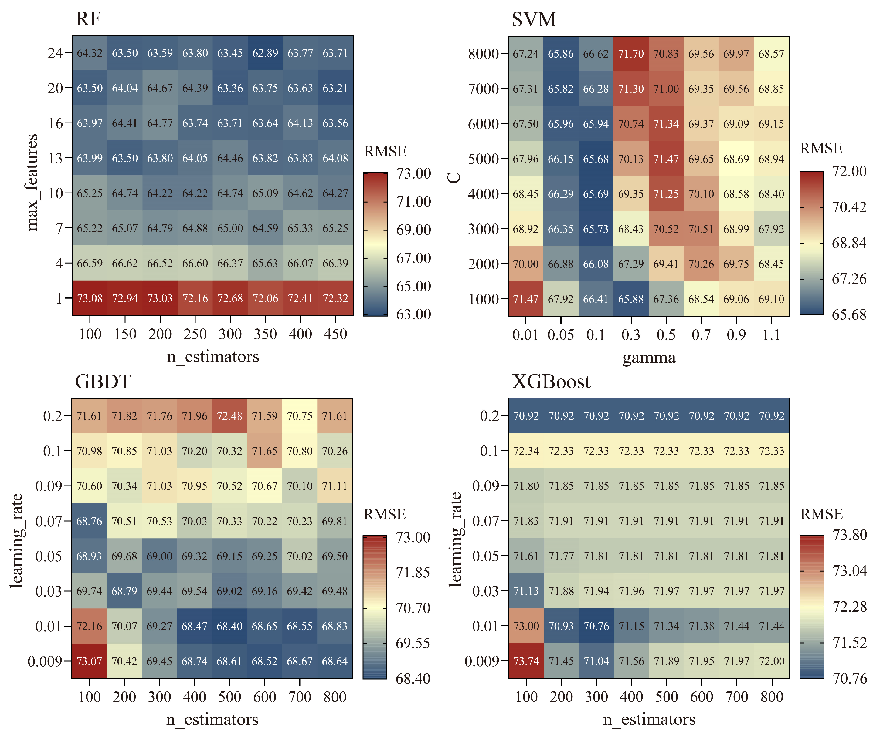
3.1. AGB Model Building and Accuracy Evaluation

Figure 3 shows the variables selection results of the four ML algorithms. As the number of variables increased, the performance of the four ML algorithms improved and then stabilized. After screening using the cross-validated recursive feature elimination algorithm, the GBDT model retained only seven variables, indicating redundancy and high correlation among potential variables. The RF model had the lowest RMSE when eight variables were retained and the model accuracy did not change significantly with an increase in variables. The SVM and XGBoost models achieved the best performance, retaining 18 and 31 variables, respectively.
Table 4 shows the specific variables chosen by the four ML algorithms. The variables selected for the RF model included: NDVI, EVI, DVI, GNDVI, MSAVI, LAI, IDM, and longitude. The variables selected by the SVM model covered the remaining six types of variables except for GLCM, including Band1, Band2, Band7, NDVI, EVI, DVI, GNDVI, MSAVI, OSAVI, RVI, SAVI, NPP, LAI, LST, slope, bulk density, ET, and longitude. The variables selected by the GBDT model were NDVI, EVI, DVI, GNDVI, MSAVI, LAI, and longitude. The XGBoost model selected all variables except pH, water content, and variance.
Figure 4 shows the model performances of the four algorithms under different hyperparameter combinations. The RF algorithm achieved high accuracy when the max_features parameter ranged between 13 and 24, with optimal performance at n_estimators set to 350 and max_features at 24. The SVM algorithm showed high accuracy when gamma value ranged from 0.05 to 0.3, achieving optimal performance at a gamma of 0.1 and a C value of 5000. The GBDT algorithm performed optimally with n_estimators at 500 and learning_rate at 0.01. The heat map of XGBoost’s hyperparameter searching grid shows a horizontal bar pattern, which indicates that XGBoost is not sensitive to the setting of the n_estimators parameter, whereas the adjustment of the learning_rate parameter significantly affects model accuracy. The XGBoost algorithm performed best with n_estimators at 300 and learning_rate at 0.01.
Figure 5 shows the prediction accuracies of the four optimized ML algorithms. After variables selection and hyperparameter optimization, the four AGB prediction models were simplified and their performance was improved. For the test dataset, RF exhibited the highest prediction accuracy (R2 = 0.67, RMSE = 56.10, MAE = 39.06), followed by the GBDT (R2 = 0.64, RMSE = 58.14, MAE = 38.66), XGBoost (R2 = 0.62, RMSE = 60.28, MAE = 44.62), and SVM (R2 = 0.56, RMSE = 64.37, MAE = 40.37). The XGBoost model performed best on the training dataset, with an R2 as high as 0.91; however, the testing dataset’s prediction accuracy was lower compared to the RF model, and the stability of the model was poor. This may be due to the XGBoost model overfitting the training dataset and failing to make accurate predictions for the unseen datasets. Therefore, based on testing dataset performance, we chose the RF model to estimate AGB in the study area.

3.2. Spatiotemporal Variation of Grassland Biomass Carbon Storage

3.2.1. Spatial Distribution of Grassland Biomass Carbon Density

The biomass carbon density in the growing peak season in Hulunbuir Grassland exhibited significant spatial heterogeneity, increasing from west to east (Figure 6). The average TB carbon density from 2001 to 2022 was 1037.10 gC/m2, among which the average AGB carbon density was 48.73 gC/m2 and the average BGB carbon density was 988.37 gC/m2. The TB carbon densities ranged from 172.86 to 5496.56 gC/m2. High TB were primarily found in the EG, OB, HL, EW, and southeastern NBL regions, characterized by meadow grasslands with dense vegetation. In contrast, low TB were mainly observed in the NBR, MZ, and western NBL regions, characterized by sparse vegetation.

3.2.2. Change Trend of Grassland Biomass Carbon Storage from 2001 to 2022

The interannual variation trend of biomass carbon storage and grassland area in the Hulunbuir Grassland is shown in Figure 7. From 2001 to 2022, the TB carbon density and TB carbon storage showed insignificant growth trends (p > 0.05). The 22-year average TB carbon density was 1037.10 gC/m2 and increased from 712.43 gC/m2 in 2001 to 1301.69 gC/m2 in 2022. The 22-year average carbon storage of TB was 72.34 ± 18.07 TgC (AGB carbon storage was 3.39 ± 0.85 TgC, BGB carbon storage was 68.95 ± 17.22 TgC) and increased from 50.01 TgC in 2001 to 89.45 TgC in 2022, with a net increase of 39.44 TgC. At the same time, the grassland area of Hulunbuir Grassland exhibited a significant decline, decreasing from 70,203.35 km2 in 2001 to 68,718.57 km2 in 2022, a net decrease of 1484.78 km2. In general, due to the combined effects of increased grassland biomass carbon density and reduced grassland area, the biomass carbon storage of the Hulunbuir Grassland showed an increasing trend.
Figure 8 shows the change trend and significance test results for grassland biomass carbon density on the pixel scale from 2001 to 2022 in the study area. The annual TB carbon density change rate of grassland ranged from −195.03 to 148.20 gC/m2. On average, TB carbon density in the Hulunbuir Grassland increased annually by 15.79 gC/m2. In 18.25% of the study area, mostly in the NBL, the western and northern parts of NBR, and the western part of OB, there was a significant increase in TB carbon density. Grasslands with slight TB carbon density increase accounted for 70.68%, spread across the entire study area. Areas with a significant decrease in TB carbon density comprised 0.92%, while those with a slight decrease made up 10.15%, mainly located around the river and in the southern part of NBR.

3.3. Driving Factors of Spatiotemporal Variation of Biomass Carbon Density

3.3.1. Driving Factors of Grassland Biomass Carbon Density Spatial Distribution

Figure 9a shows the single-factor detection results of the spatial distribution of biomass carbon density in the Hulunbuir Grassland in 2001, 2010, and 2020. The q values of the eight factors were ranked as follows: ET > TEM > PRE > SOI > DEM > UI > SLO > POP. Notably, ET, TEM, and PRE had the highest q values, with three-year average q values of 0.631, 0.630, and 0.546, respectively, signifying their dominant influence on the spatial heterogeneity of TB carbon density. In contrast, SLO and POP had minimal impact, with three-year average q values below 0.2. From 2001 to 2010, the influence of driving factors on TB carbon density generally weakened, except for SLO, whose impact increased. From 2010–2020, the influence of DEM, UI, and POP on grassland TB carbon density increased, while the influence of TEM, PRE, ET, SLO, and SOI on grassland TB carbon density decreased.
As shown in Figure 9b, the interaction between any two factors resulted in a higher q value than a single factor, indicating that the combined effects enhanced the spatial differentiation of grassland TB carbon density. The factor interactions were bivariate and nonlinear enhancements. The interactions between TEM, PRE, ET, DEM, SLO, SOI, and UI with other factors mostly exhibited bivariate enhancement, whereas the interaction between POP and other factors showed more nonlinear enhancement. Among the interactions of factors, the interactions between ET and TEM, ET and PRE, and ET and SOI were stronger. This further indicated that ET, TEM, and PRE were the key drivers of the spatial differentiation of TB carbon density in the Hulunbuir Grassland.

3.3.2. Driving Factors of Time Variations in Grassland Biomass Carbon Density

Figure 10a demonstrates that the combined effects of CC and HA increased carbon density in 50.98% of the area, primarily in the NBL, NBR, and OB. The area where carbon density increased due to CC alone occurred in 37.48%; the area of carbon density increase caused by HA alone accounted for 0.48%, mostly in the southern area of OB. In addition, 8.61% experienced carbon density reduction caused by HA, primarily in the southern area of NBL and NBR. The combined effects of CC and HA decreased carbon density in 2.00% of the area, primarily in the southern area of OB. The area of carbon density reduction caused by CC alone accounted for 0.46% and the distribution was relatively dispersed.
Figure 10b,c show the relative contributions of CC and HA to variations in carbon density. On average, CC contributed 74.87% to biomass carbon density changes in the Hulunbuir Grassland, while HA contributed 25.13%. CC’s influence was dominant, with relative contributions exceeding 50% in 82.71% of the area. Notably, 56.31% of the area had a CC contribution rate over 80%, primarily in the northern part of NBR and EA. HA’s contribution was generally small, with a rate exceeding 50% mainly in the southern NBR region, with an area ratio of 17.29%.

4. Discussion

4.1. Variables Selection and ML Algorithm Performance Comparison for Grassland AGB Modeling

This study evaluated the capability of spectral bands, spectral indices, terrain factors, soil factors, climate factors, location factor, and texture features in modeling AGB in the Hulunbuir Grassland. Among these, spectral indices contributed the most to modeling grassland AGB (Table 4 and Table S4), which is consistent with previous research findings [17,35,74,75]. Six vegetation indices, NDVI, EVI, DVI, GNDVI, MSAVI, and LAI, were selected for all four ML models. The Pearson correlation analysis (Table S4) indicated that these six vegetation indices exhibited significant correlations with grassland AGB, with correlation coefficients above 0.6, indicating their effectiveness in explaining spatial distribution in grassland AGB. Among them, EVI and DVI showed the highest correlation with grassland AGB at 0.738 and 0.736, respectively. EVI partly mitigates the impact of atmospheric noise and soil background, addressing the saturation problem found in previous vegetation indices [76]. Liu et al. [77] indicated that the EVI can obtain more reasonable values for reflecting vegetation coverage and yield characteristics under different vegetation densities. Xue and Su [78] suggested that the DVI, owing to its sensitivity to soil background variations, can be used in vegetation ecological environment monitoring. Therefore, this study recognizes the strong application potential of the EVI and DVI in estimating grassland AGB. In addition, longitude was selected as an effective variable in all four ML models, showing a significant correlation with AGB (r = 0.367). This may be because precipitation and temperature in the Hulunbuir region generally vary along the longitude gradient, and these climate factors are closely related to vegetation growth [79], thus resulting in a strong correlation between AGB and longitude. Neither the RF nor GBDT models, which performed well for AGB estimation, selected any of the environmental variables. This could be attributed to two reasons: (1) Some previous studies have demonstrated a strong correlation between climate, soil variables, and vegetation indices [80,81,82], but their ability to estimate AGB was inferior to that of vegetation indices; hence, these environmental variables were not selected as effective variables. (2) The accuracy and timeliness of the environmental variables dataset in this study should be improved. The climate data have a relatively low spatial resolution of 1 km, leading to scale effects. Additionally, the terrain and soil datasets were collected relatively early [83], which caused a mismatch with the sampling time of the AGB.
We utilized four common ML algorithms to construct the AGB estimation model for the Hulunbuir Grassland, and the results indicated that RF achieved the highest prediction accuracy (Figure 5). Other studies have reported similar results [66,68,84,85]. Previous studies have demonstrated that the RF algorithm exhibits strong robustness and is not affected by noisy data [86,87]. In addition, RF excels in handling multicollinearity issues among data and is less prone to overfitting [88]. SVM demonstrated the lowest estimation accuracy for AGB among the four algorithms, which could be attributed to several reasons: (1) SVM model’s performance heavily depends on parameter selection, which requires certain prior knowledge, and (2) SVM is sensitive to outliers, particularly in the presence of considerable noise or outliers in the data, which may result in reduced generalization capability for the model [89]. The GBDT model’s performance was relatively close to that of the RF model because both are ensemble decision-tree ML algorithms. The XGBoost model exhibited higher accuracy on the training dataset than the RF model; however, its performance on the test dataset was inferior to that of the RF model. This may be because the XGBoost model selected too many variables (n = 31) during the variable selection process, leading to overfitting and a poorer generalization ability on the test dataset.

4.2. Spatiotemporal Characteristics of Biomass Carbon Storage and Its Driving Factors

This study utilized an optimal ML model to estimate the AGB of the Hulunbuir Grassland from 2001 to 2022. Additionally, by integrating the R/S data, grassland distribution data, and carbon content coefficients, we estimated the BGB and TB carbon density of the Hulunbuir Grassland. The result shows that the 22-year average TB carbon density was 1037.10 gC/m2, the 22-year average AGB carbon density was 48.73 gC/m2, and the 22-year average BGB carbon density was 988.37 gC/m2. The spatial distribution of TB carbon density gradually increased from west to east (Figure 6), corresponding to the average annual temperature and precipitation patterns (Figure S1). The OPGD analysis results (Figure 9) identified ET, TEM, and PRE as the main factors influencing the spatial heterogeneity of grassland carbon density, with three-year average q values of 0.631, 0.630, and 0.546, respectively. In other words, climatic factors were the key drivers of the spatial differentiation of grassland biomass carbon density in the Hulunbuir area, consistent with previous research [17,90,91]. ET is mainly composed of soil evaporation, vegetation transpiration, and vegetation canopy interception evaporation [92] and is a link connecting the global carbon, water, and energy cycles [93]. Yang et al. [94] showed that an increase in the leaf area index was closely related to an increase in ET. Therefore, in regions with lush vegetation growth, which have higher biomass carbon density, ET values also increase. In addition, driving factor analysis revealed that temperature significantly influenced the spatial distribution of grassland biomass carbon density. Suitable temperature conditions and sufficient heat resources are necessary environmental conditions to ensure the normal physiological activities of plants. In particular, the dominant effect of spring temperatures on grassland vegetation is significantly greater than that of precipitation [95] and an increase in spring temperatures is conducive to plant germination and growth. Precipitation also has an important effect on grassland vegetation growth [95,96], particularly in arid and semiarid regions where water stress frequently occurs [97]. Most studies have used county-level administrative unit data to investigate the impacts of human factors on grassland biomass and carbon storage [8,10,17]. In the process of spatializing these data, the values of the same county-level units are the same, which inevitably generates pixel-scale errors and introduces uncertainty in analyzing the driving factors. Therefore, to enhance the precision of the anthropogenic driver analysis, we utilized population density and grassland utilization intensity data with a 1 km spatial resolution. The results showed that human factors, such as grassland utilization intensity and population density, had a weak driving force on the spatial differentiation of grassland biomass carbon density compared to climate factors, but the driving force of these human factors showed an increasing trend annually. Therefore, we suggest that the Hulunbuir Grassland should strengthen its grazing management to prevent overgrazing.
In terms of interannual variation trend, 88.93% of the Hulunbuir Grassland area showed an increasing trend in biomass carbon density, averaging an annual increase of 15.79 gC/m2 (Figure 8). Numerous studies have identified CC and HA as the main drivers of grassland change [98,99,100]. In this study, residual analysis was employed to quantitatively separate the impacts of CC and HA on the interannual variation in biomass carbon density. The results indicated that the combined impact of CC and HA was the main factor behind the increase in biomass carbon density in the Hulunbuir Grassland over the past 22 years. Among them, CC was the dominant factor, with an average contribution rate of approximately 74.87%. From 2001 to 2022, both temperature and precipitation in the Hulunbuir Grassland have shown an increasing trend (Figure S1). The Hulunbuir Grassland is a semi-arid region, and previous studies have shown that humid and warm climates support vegetation growth in arid and semi-arid regions [101,102]. Increased precipitation enhances soil water infiltration and reduces evaporation loss, which can better stimulate plant growth and the carbon cycle [103,104]. Climate warming prolongs the vegetation growth cycle, which is beneficial for vegetation growth and biomass accumulation [95]. The positive impact of HA on the biomass carbon density of the Hulunbuir Grassland is largely attributable to the ecological project of reverting grazing lands to grassland and the incentive policy of grassland ecological protection implemented by China in 2000 [105,106]. These initiatives have made important contributions to grassland vegetation restoration in China’s arid and semi-arid regions. Cai et al. [107] evaluated the impact of ecological engineering on vegetation restoration in China’s arid and semi-arid regions, indicating that CC is the primary factor in vegetation restoration; ecological engineering also contributes significantly to vegetation restoration in this region, which is consistent with the results of this study. Although most areas of the Hulunbuir Grassland exhibited an increasing trend in biomass carbon density, it still exhibited a decreasing trend in 11.07% of areas, primarily located in the southern part of NBR (Figure 8). Specifically, HA was the primary cause of the reduction in biomass carbon density, with an average contribution rate of approximately 89.25%. This may have been due to overgrazing in these areas. Increased grazing intensity significantly decreases plant biomass, vegetation coverage, abundance, and soil nutrient content of grassland ecosystems [108]. Therefore, reducing the interference and pressure of HA on grasslands, as well as adopting fencing and banning grazing, can enhance grassland plant productivity and carbon sink functions [109,110].
The annual variation in grassland biomass carbon storage was caused by changes in carbon density within the grassland as well as changes in grassland area. However, most studies analyzing changes in grassland biomass and carbon storage have not considered the impact of changes in land-use types [10,44], leading to estimation errors. To address this, we analyzed how changes in grassland area influenced biomass carbon storage. From 2001 to 2022, while most of the Hulunbuir Grassland remained stable, the net grassland area decreased by 1484.84 km2 (Figure S2), resulting in a net loss of 2.43 TgC, approximately 2.72% of the TB carbon storage, by 2022. Afforestation and land reclamation were the main causes of grassland area reduction and carbon storage loss in the Hulunbuir Grassland, leading to a decrease of 5.55 TgC. However, the conversion of farmland to grassland and the reduction of forests primarily contributed to the increase in grassland area. This change led to a rise in grassland biomass carbon storage by 3.12 TgC. Overall, despite a reduction in grassland area, the biomass carbon storage of Hulunbuir Grassland increased by 39.44 TgC due to the increase of grassland biomass carbon density from 2001 to 2022. This indicates that the Hulunbuir Grassland has a significant carbon sequestration potential. Therefore, relevant government departments should scientifically plan land use for urban development and agricultural production, implement farmland-to-grassland conversion measures, and strengthen the protection and restoration of grasslands.

4.3. Limitations and Prospects

The optimal model, while achieving good predictive accuracy in estimating AGB, still exhibited limitations and uncertainties: (1) the optimal model underestimated the high AGB value of grassland. The relatively small sample size of high-value AGB in this study, in contrast to the larger sample size of low-value AGB, may be the cause. The RF algorithm, comprising multiple decision trees, averages the results of all trees for the final prediction [111]. Therefore, if there are fewer samples with high values, this average may be influenced by samples with low values, causing the final prediction to be biased towards low values. (2) There may be a time mismatch between the sampled data and the satellite remote sensing data. MODIS reflectance data and vegetation index products were mostly synthesized in eight days, which does not completely coincide with the time at which we collected AGB in the field, increasing model uncertainty. (3) The accuracy of the terrain, soil, and climate datasets should be improved. The spatial resolution of the climate dataset utilized in this study is 1 km, which requires improvement. In addition, topographic and soil data were collected earlier [83] and there was a time mismatch problem with the collected AGB. These variables were not selected in the optimal model; therefore, there was no corresponding error in model construction. However, these variables may still be valid, and their spatiotemporal resolutions need to be improved. Based on the above limitations, follow-up can be improved in the following ways: (1) expanding the sample size of high-value AGB, (2) enhancing the spatiotemporal alignment between the sampled and remote sensing data, and (3) developing environmental factor datasets with higher spatial and temporal resolutions.
Accurate estimation of BGB is crucial for assessing regional biomass carbon storage. In grassland ecosystems, the allocation ratio of the BGB is significantly higher than that of the AGB [32,112]. Therefore, precise BGB estimation is vital for evaluating the role of grassland ecosystems in the regional carbon budget [113]. However, owing to the limitations of sampling methods, BGB data are scarce. Currently, estimating grassland BGB based on AGB and the R/S is a commonly employed method. Therefore, more survey data at the regional scale are needed to obtain more accurate R/S data. Based on the measured AGB and BGB data, we obtained a constant R/S of grassland type to estimate BGB, which reduced the uncertainty in grassland biomass carbon storage estimates to a certain extent. However, this study had some limitations. It was assumed that R/S depends on grassland type and does not change with changes in the environment or climate [3,44], which might cause some uncertainties and errors in the spatiotemporal pattern analysis of the BGB. Environmental factors and HA may affect the R/S. For instance, Luo et al. [114] discovered a correlation between R/S and the annual mean temperature and precipitation in temperate grasslands of northern China; R/S increased with decreasing precipitation and rising temperature. Yan et al. [115] observed that grazing significantly reduced AGB and increased R/S in Tibetan Plateau grasslands. To address these limitations, future studies can: (1) increase the number of BGB measured data points of different grassland types and (2) integrate vegetation indices, climate, topography, and soil environmental remote sensing data and utilizing ML algorithms to construct a more accurate BGB estimation model.
This study employed residual analysis to quantify the effects of CC and HA on TB changes in the Hulunbuir Grassland. While this method is simple and easy to use, it has several limitations: (1) it only analyzed the overall impact of CC and HA on vegetation TB, without detailing the influence of specific climatic and anthropogenic factors. (2) The method used multiple linear regression to establish relationships between climatic factors and vegetation changes, which overlooked the nonlinear relationships among variables to some extent. Given these limitations, future studies can improve in the following ways: (1) refine the analysis of individual climatic and anthropogenic factors affecting vegetation TB, such as temperature, precipitation, population density, and grazing intensity; (2) incorporate ML algorithms to enhance traditional residual analysis.

5. Conclusions

We focused on the Hulunbuir Grassland, utilizing sample plots data, MODIS data, environmental factors (terrain, soil, and climate), location factor, and texture characteristics to assess the performance of four ML algorithms, RF, SVM, GBDT, and XGBoost, in estimating grassland AGB. Based on the optimal model combined with R/S data, grassland distribution data, and carbon content coefficients, the spatiotemporal characteristics and driving factors of biomass carbon storage from 2001 to 2022 were analyzed. The results showed that (1) RF achieved the highest prediction accuracy for grassland AGB (R2 = 0.67, RMSE = 56.10, MAE = 39.06), which was suitable for AGB estimation in the Hulunbuir Grassland area; (2) The spectral indices made the greatest contribution to the grassland AGB model, especially NDVI, EVI, DVI, GNDVI, MSAVI, and LAI, which were selected in all four ML models; (3) The 22-year average TB of the study area was 1037.10 gC/m2, of which the 22-year average AGB was 48.73 gC/m2 and the 22-year average BGB was 988.37 gC/m2, showing a spatial distribution feature of gradual increase from west to east; (4) From 2001–2022, the TB carbon storage showed an increasing trend. The 22-year average carbon storage of TB was 72.34 ± 18.07 TgC (AGB carbon storage was 3.39 ± 0.85 TgC, BGB carbon storage was 68.95 ± 17.22 TgC); (5) Climate factors, particularly evapotranspiration and temperature, were the main driving factors of TB spatial pattern of grassland TB carbon density, while the combined effects of CC and HA were the main contributors to the increase in grassland TB carbon density. The CC played a leading role in this increase in carbon density, with an average contribution rate of approximately 74.87%. This study holds significant implications for improving the quantification of grassland carbon storage and for understanding the effects of CC and HA on it.

Supplementary Materials

The following supporting information can be downloaded at: https://www.mdpi.com/article/10.3390/rs16193709/s1, Figure S1: Average annual temperature (a), the change trend (slope) of annual temperature (b), average annual precipitation (c), and the change trend (slope) of annual precipitation (d) from 2001 to 2022; Figure S2: The changes in grassland area (a) and the changes in carbon storage of grassland biomass caused by changes in land cover (b) in the Hulunbuir Grassland from 2001 to 2022; Table S1: The calculation formulae of vegetation indices; Table S2: The calculation formulae of GLCM indices; Table S3: Natural and human factors on the spatial differentiation of grassland TB; Table S4: Pearson correlation between grassland AGB and remote sensing and environmental variables. References [53,54,116,117,118,119,120,121,122,123] are cited in the Supplementary Materials.

Author Contributions

Conceptualization, Q.Z. and J.L.; software, Q.Z.; formal analysis, Q.Z.; investigation, Q.Z., X.H., P.W., M.L., Y.D., Y.W., T.P. and W.L.; data curation, X.H.; writing—original draft preparation, Q.Z.; writing—review and editing, X.G., X.S. and J.L.; visualization, Q.Z.; supervision, M.L.; project administration, P.W.; funding acquisition, J.L. All authors have read and agreed to the published version of the manuscript.

Funding

This research was funded by the Hulunbuir Grassland Ecological Restoration Comprehensive Survey Project (No. DD20230474).

Data Availability Statement

The data presented in this study are available on request from the corresponding author due to privacy.

Conflicts of Interest

The authors declare no conflicts of interest.

References

  1. Zillmann, E.; Gonzalez, A.; Herrero, E.J.M.; van Wolvelaer, J.; Esch, T.; Keil, M.; Weichelt, H.; Garzon, A.M. Pan-European Grassland Mapping Using Seasonal Statistics From Multisensor Image Time Series. IEEE J. Sel. Top. Appl. Earth Observ. Remote Sens. 2014, 7, 3461–3472. [Google Scholar] [CrossRef]
  2. Li, G.Y.; Han, H.Y.; Du, Y.; Hui, D.F.; Xia, J.Y.; Niu, S.L.; Li, X.N.; Wan, S.Q. Effects of warming and increased precipitation on net ecosystem productivity: A long-term manipulative experiment in a semiarid grassland. Agric. For. Meteorol. 2017, 232, 359–366. [Google Scholar] [CrossRef]
  3. Scurlock, J.M.O.; Johnson, K.; Olson, R.J. Estimating net primary productivity from grassland biomass dynamics measurements. Glob. Chang. Biol. 2002, 8, 736–753. [Google Scholar] [CrossRef]
  4. Tang, X.; Zhao, X.; Bai, Y.; Tang, Z.; Wang, W.; Zhao, Y.; Wan, H.; Xie, Z.; Shi, X.; Wu, B. Carbon pools in China’s terrestrial ecosystems: New estimates based on an intensive field survey. Proc. Natl. Acad. Sci. USA 2018, 115, 4021–4026. [Google Scholar] [CrossRef]
  5. Cui, F.; Tang, H.; Zhang, Q.; Wang, B.; Dai, L. Integrating ecosystem services supply and demand into optimized management at different scales: A case study in Hulunbuir, China. Ecosyst. Serv. 2019, 39, 100984. [Google Scholar] [CrossRef]
  6. Li, M.; Wang, X.; Chen, J. Assessment of grassland ecosystem services and analysis on its driving factors: A case study in Hulunbuir Grassland. Front. Ecol. Evol. 2022, 10, 10. [Google Scholar] [CrossRef]
  7. Na, R.; Du, H.; Na, L.; Shan, Y.; He, H.S.; Wu, Z.; Zong, S.; Yang, Y.; Huang, L. Spatiotemporal changes in the Aeolian desertification of Hulunbuir Grassland and its driving factors in China during 1980–2015. Catena 2019, 182, 10. [Google Scholar] [CrossRef]
  8. Chang, C.; Chang, Y.; Xiong, Z.; Liu, H.; Bu, R. Estimating the aboveground biomass of the Hulunbuir Grassland and exploring its spatial and temporal variations over the past ten years. Ecol. Indic. 2024, 161, 12. [Google Scholar] [CrossRef]
  9. Zhu, X.H.; Chen, X.Y.; Ma, L.L.; Liu, W. UAV and Satellite Synergies for Mapping Grassland Aboveground Biomass in Hulunbuir Meadow Steppe. Plants 2024, 13, 19. [Google Scholar] [CrossRef]
  10. Ding, L.; Li, Z.W.; Shen, B.B.; Wang, X.; Xu, D.W.; Yan, R.R.; Yan, Y.C.; Xin, X.P.; Xiao, J.F.; Li, M.; et al. Spatial patterns and driving factors of aboveground and belowground biomass over the eastern Eurasian steppe. Sci. Total Environ. 2022, 803, 149700. [Google Scholar] [CrossRef]
  11. Paul, K.I.; Roxburgh, S.H.; England, J.R.; Ritson, P.; Hobbs, T.; Brooksbank, K.; Raison, R.J.; Larmour, J.S.; Murphy, S.; Norris, J. Development and testing of allometric equations for estimating above-ground biomass of mixed-species environmental plantings. For. Ecol. Manag. 2013, 310, 483–494. [Google Scholar] [CrossRef]
  12. Wang, S.; Tuya, H.; Zhang, S.W.; Zhao, X.Y.; Liu, Z.Q.; Li, R.S.; Lin, X. Random forest method for analysis of remote sensing inversion of aboveground biomass and grazing intensity of grasslands in Inner Mongolia, China. Int. J. Remote Sens. 2023, 44, 2867–2884. [Google Scholar] [CrossRef]
  13. Lyu, X.; Li, X.; Gong, J.; Li, S.; Dou, H.; Dang, D.; Xuan, X.; Wang, H. Remote-sensing inversion method for aboveground biomass of typical steppe in Inner Mongolia, China. Ecol. Indic. 2021, 120, 106883. [Google Scholar] [CrossRef]
  14. Ali, I.; Cawkwell, F.; Dwyer, E.; Barrett, B.; Green, S. Satellite remote sensing of grasslands: From observation to management. J. Plant Ecol. 2016, 9, 649–671. [Google Scholar] [CrossRef]
  15. Huang, W.; Li, W.; Xu, J.; Ma, X.; Li, C.; Liu, C. Hyperspectral monitoring driven by machine learning methods for grassland above-ground biomass. Remote Sens. 2022, 14, 2086. [Google Scholar] [CrossRef]
  16. Yan, X.; Li, J.; Smith, A.R.; Yang, D.; Ma, T.; Su, Y.; Shao, J. Evaluation of machine learning methods and multi-source remote sensing data combinations to construct forest above-ground biomass models. Int. J. Digit. Earth 2023, 16, 4471–4491. [Google Scholar] [CrossRef]
  17. Wu, N.T.; Liu, G.X.; Wuyun, D.; Yi, B.L.; Du, W.L.; Han, G.D. Spatial-Temporal Characteristics and Driving Forces of Aboveground Biomass in Desert Steppes of Inner Mongolia, China in the Past 20 Years. Remote Sens. 2023, 15, 20. [Google Scholar] [CrossRef]
  18. Vahedi, A.A. Artificial neural network application in comparison with modeling allometric equations for predicting above-ground biomass in the Hyrcanian mixed-beech forests of Iran. Biomass Bioenergy 2016, 88, 66–76. [Google Scholar] [CrossRef]
  19. Chen, P.; Wang, S.; Liu, Y.; Wang, Y.; Song, J.; Tang, Q.; Yao, Y.; Wang, Y.; Wu, X.; Wei, F. Spatio-temporal dynamics of aboveground biomass in China’s oasis grasslands between 1989 and 2021. Earth’s Future 2024, 12, e2023EF003944. [Google Scholar] [CrossRef]
  20. Li, Y.; Li, M.; Li, C.; Liu, Z. Forest aboveground biomass estimation using Landsat 8 and Sentinel-1A data with machine learning algorithms. Sci. Rep. 2020, 10, 9952. [Google Scholar] [CrossRef]
  21. Jia, Z.Y.; Zhang, Z.H.; Cheng, Y.X.; Buhebaoyin; Borjigin, S.; Quan, Z.J. Grassland biomass spatiotemporal patterns and response to climate change in eastern Inner Mongolia based on XGBoost model estimates. Ecol. Indic. 2024, 158, 111554. [Google Scholar] [CrossRef]
  22. Luo, W.; Zhang, C.; Zhao, X.; Liang, J. Understanding patterns and potential drivers of forest diversity in northeastern China using machine-learning algorithms. J. Veg. Sci. 2021, 32, e13022. [Google Scholar] [CrossRef]
  23. Liang, T.; Yang, S.; Feng, Q.; Liu, B.; Zhang, R.; Huang, X.; Xie, H. Multi-factor modeling of above-ground biomass in alpine grassland: A case study in the Three-River Headwaters Region, China. Remote Sens. Environ. 2016, 186, 164–172. [Google Scholar] [CrossRef]
  24. Muro, J.; Linstädter, A.; Magdon, P.; Wöllauer, S.; Männer, F.A.; Schwarz, L.-M.; Ghazaryan, G.; Schultz, J.; Malenovský, Z.; Dubovyk, O. Predicting plant biomass and species richness in temperate grasslands across regions, time, and land management with remote sensing and deep learning. Remote Sens. Environ. 2022, 282, 113262. [Google Scholar] [CrossRef]
  25. Wang, Y.; Liu, Y.; Chen, P.; Song, J.; Fu, B. Interannual precipitation variability dominates the growth of alpine grassland above-ground biomass at high elevations on the Tibetan Plateau. Sci. Total Environ. 2024, 931, 172745. [Google Scholar] [CrossRef]
  26. Zhou, J.; Zhang, R.; Guo, J.; Dai, J.; Zhang, J.; Zhang, L.; Miao, Y. Estimation of aboveground biomass of senescence grassland in China’s arid region using multi-source data. Sci. Total Environ. 2024, 918, 170602. [Google Scholar] [CrossRef]
  27. Argamosa, R.J.L.; Blanco, A.C.; Baloloy, A.B.; Candido, C.G.; Dumalag, J.B.L.C.; Dimapilis, L.L.C.; Paringit, E.C. Modelling above ground biomass of mangrove forest using Sentinel-1 imagery. ISPRS Ann. Photogramm. Remote Sens. Spat. Inf. Sci. 2018, 4, 13–20. [Google Scholar] [CrossRef]
  28. Rosas-Chavoya, M.; López-Serrano, P.M.; Vega-Nieva, D.J.; Hernández-Díaz, J.C.; Wehenkel, C.; Corral-Rivas, J.J. Estimating above-ground biomass from land surface temperature and evapotranspiration data at the temperate forests of Durango, Mexico. Forests 2023, 14, 299. [Google Scholar] [CrossRef]
  29. Wu, N.T.; Crusiol, L.G.T.; Liu, G.X.; Wuyun, D.; Han, G.D. Comparing Machine Learning Algorithms for Pixel/Object-Based Classifications of Semi-Arid Grassland in Northern China Using Multisource Medium Resolution Imageries. Remote Sens. 2023, 15, 22. [Google Scholar] [CrossRef]
  30. Mokany, K.; Raison, R.J.; Prokushkin, A.S. Critical analysis of root: Shoot ratios in terrestrial biomes. Glob. Chang. Biol. 2006, 12, 84–96. [Google Scholar] [CrossRef]
  31. Fan, J.; Zhong, H.; Harris, W.; Yu, G.; Wang, S.; Hu, Z.; Yue, Y. Carbon storage in the grasslands of China based on field measurements of above- and below-ground biomass. Clim. Chang. 2008, 86, 375–396. [Google Scholar] [CrossRef]
  32. Yang, Y.H.; Fang, J.Y.; Ji, C.J.; Han, W.X. Above- and belowground biomass allocation in Tibetan grasslands. J. Veg. Sci. 2009, 20, 177–184. [Google Scholar] [CrossRef]
  33. Ma, W.; Fang, J.; Yang, Y.; Mohammat, A. Biomass carbon stocks and their changes in northern China’s grasslands during 1982–2006. Sci. China Life Sci. 2010, 53, 841–850. [Google Scholar] [CrossRef] [PubMed]
  34. Ma, H.Z.; Mo, L.D.; Crowther, T.W.; Maynard, D.S.; van den Hoogen, J.; Stocker, B.D.; Terrer, C.; Zohner, C.M. The global distribution and environmental drivers of aboveground versus belowground plant biomass. Nat. Ecol. Evol. 2021, 5, 1110–1122. [Google Scholar] [CrossRef]
  35. Yang, D.; Yang, Z.Y.; Wen, Q.K.; Ma, L.C.; Guo, J.; Chen, A.; Zhang, M.; Xing, X.Y.; Yuan, Y.X.; Lan, X.Y.; et al. Dynamic monitoring of aboveground biomass in inner Mongolia grasslands over the past 23 Years using GEE and analysis of its driving forces. J. Environ. Manag. 2024, 354, 120415. [Google Scholar] [CrossRef]
  36. Zhou, W.; Li, H.R.; Xie, L.J.; Nie, X.M.; Wang, Z.; Du, Z.P.; Yue, T.X. Remote sensing inversion of grassland aboveground biomass based on high accuracy surface modeling. Ecol. Indic. 2021, 121, 107215. [Google Scholar] [CrossRef]
  37. Zhang, G.P.; Yan, J.J.; Zhu, X.T.; Ling, H.B.; Xu, H.L. Spatio-temporal variation in grassland degradation and its main drivers, based on biomass: Case study in the Altay Prefecture, China. Glob. Ecol. Conserv. 2019, 20, e00723. [Google Scholar] [CrossRef]
  38. Sun, Y.F.; Yang, Y.H.; Zhao, X.; Tang, Z.Y.; Wang, S.P.; Fang, J.Y. Global patterns and climatic drivers of above- and belowground net primary productivity in grasslands. Sci. China-Life Sci. 2021, 64, 739–751. [Google Scholar] [CrossRef]
  39. Zhang, J.; Fang, S.B.; Liu, H.H. Estimation of alpine grassland above-ground biomass and its response to climate on the Qinghai-Tibet Plateau during 2001 to 2019. Glob. Ecol. Conserv. 2022, 35, e02065. [Google Scholar] [CrossRef]
  40. Li, Y.Q.; Wang, X.Y.; Chen, Y.; Gong, X.W.; Yao, C.P.; Cao, W.J.; Lian, J. Application of predictor variables to support regression kriging for the spatial distribution of soil organic carbon stocks in native temperate grasslands. J. Soils Sediments 2023, 23, 700–717. [Google Scholar] [CrossRef]
  41. Yan, R.R.; Yu, T.Q.; Liu, H.M.; Lv, S.J.; Chen, B.R.; Wu, Y.L.; Que, G.P.; Wei, Z.J.; Xu, L.J.; Zhu, X.Y.; et al. Effects of different grassland utilization methods on the germinable soil seed bank of the Hulunbuir meadow steppe. Front. Plant Sci. 2023, 14, 1230725. [Google Scholar] [CrossRef] [PubMed]
  42. Song, X.; Li, C.R.; Zhang, H.Q. Hulunbuir has built a comprehensive wildlife protection system. Inn. Mong. For. 2022, 3, 24–25. (In Chinese) [Google Scholar]
  43. Alima. The Carbon Storage and Ecological Stoichiometry Study of Different Communities in HulunBuir Grassland; Inner Mongolia Normal University: Hohhot, China, 2016. (In Chinese) [Google Scholar]
  44. Piao, S.L.; Fang, J.Y.; Zhou, L.M.; Tan, K.; Tao, S. Changes in biomass carbon stocks in China’s grasslands between 1982 and 1999. Glob. Biogeochem. Cycle 2007, 21, 10. [Google Scholar] [CrossRef]
  45. Yang, J.; Huang, X. The 30 m annual land cover dataset and its dynamics in China from 1990 to 2019. Earth Syst. Sci. Data 2021, 13, 3907–3925. [Google Scholar] [CrossRef]
  46. Hou, M.J.; Ge, J.; Xiu, Y.J.; Meng, B.P.; Liu, J.; Feng, Q.S.; Liang, T.G. The urgent need to develop a new grassland map in China: Based on the consistency and accuracy of ten land cover products. Sci. China-Life Sci. 2023, 66, 385–405. [Google Scholar] [CrossRef]
  47. Liang, Y.Y.; Kou, W.L.; Lai, H.Y.; Wang, J.; Wang, Q.H.; Xu, W.H.; Wang, H.; Lu, N. Improved estimation of aboveground biomass in rubber plantations by fusing spectral and textural information from UAV-based RGB imagery. Ecol. Indic. 2022, 142, 109286. [Google Scholar] [CrossRef]
  48. Wang, L.J.; Wang, J.Y.; Zhang, X.W.; Wang, L.G.; Qin, F. Deep segmentation and classification of complex crops using multi-feature satellite imagery. Comput. Electron. Agric. 2022, 200, 107249. [Google Scholar] [CrossRef]
  49. Jin, Y.H.; Liu, X.P.; Chen, Y.M.; Liang, X. Land-cover mapping using Random Forest classification and incorporating NDVI time-series and texture: A case study of central Shandong. Int. J. Remote Sens. 2018, 39, 8703–8723. [Google Scholar] [CrossRef]
  50. Roy, D.P.; Kovalskyy, V.; Zhang, H.K.; Vermote, E.F.; Yan, L.; Kumar, S.S.; Egorov, A. Characterization of Landsat-7 to Landsat-8 reflective wavelength and normalized difference vegetation index continuity. Remote Sens. Environ. 2016, 185, 57–70. [Google Scholar] [CrossRef]
  51. Teillet, P.M.; Markham, B.L.; Irish, R.R. Landsat cross-calibration based on near simultaneous imaging of common ground targets. Remote Sens. Environ. 2006, 102, 264–270. [Google Scholar] [CrossRef]
  52. Gorelick, N.; Hancher, M.; Dixon, M.; Ilyushchenko, S.; Thau, D.; Moore, R. Google Earth Engine: Planetary-scale geospatial analysis for everyone. Remote Sens. Environ. 2017, 202, 18–27. [Google Scholar] [CrossRef]
  53. Baraldi, A.; Parmiggiani, F. An investigation of the textural characteristics associated with gray-level cooccurrence matrix statistical parameters. IEEE Trans. Geosci. Remote Sens. 1995, 33, 293–304. [Google Scholar] [CrossRef]
  54. Hall-Beyer, M. Practical guidelines for choosing GLCM textures to use in landscape classification tasks over a range of moderate spatial scales. Int. J. Remote Sens. 2017, 38, 1312–1338. [Google Scholar] [CrossRef]
  55. Guo, Z.Q.; Liu, H.L.; Zheng, Z.Z.; Chen, X.; Liang, Y. Accurate Extraction of Mountain Grassland From Remote Sensing Image Using a Capsule Network. IEEE Geosci. Remote Sens. Lett. 2021, 18, 964–968. [Google Scholar] [CrossRef]
  56. Zhao, P.P.; Lu, D.S.; Wang, G.X.; Wu, C.P.; Huang, Y.J.; Yu, S.Q. Examining Spectral Reflectance Saturation in Landsat Imagery and Corresponding Solutions to Improve Forest Aboveground Biomass Estimation. Remote Sens. 2016, 8, 469. [Google Scholar] [CrossRef]
  57. Breiman, L. Random forests. Mach. Learn. 2001, 45, 5–32. [Google Scholar] [CrossRef]
  58. Wu, N.T.; Crusiol, L.G.T.; Liu, G.X.; Wuyun, D.; Han, G.D. Comparing the performance of machine learning algorithms for estimating aboveground biomass in typical steppe of northern China using Sentinel imageries. Ecol. Indic. 2023, 154, 110723. [Google Scholar] [CrossRef]
  59. Cortes, C.; Vapnik, V. Support-vector networks. Mach. Learn. 1995, 20, 273–297. [Google Scholar] [CrossRef]
  60. Friedman, J.H. Greedy function approximation: A gradient boosting machine. Ann. Stat. 2001, 29, 1189–1232. [Google Scholar] [CrossRef]
  61. Pham, T.D.; Le, N.N.; Ha, N.T.; Nguyen, L.V.; Xia, J.S.; Yokoya, N.; To, T.T.; Trinh, H.X.; Kieu, L.Q.; Takeuchi, W. Estimating Mangrove Above-Ground Biomass Using Extreme Gradient Boosting Decision Trees Algorithm with Fused Sentinel-2 and ALOS-2 PALSAR-2 Data in Can Gio Biosphere Reserve, Vietnam. Remote Sens. 2020, 12, 777. [Google Scholar] [CrossRef]
  62. Emadi, M.; Taghizadeh-Mehrjardi, R.; Cherati, A.; Danesh, M.; Mosavi, A.; Scholten, T. Predicting and Mapping of Soil Organic Carbon Using Machine Learning Algorithms in Northern Iran. Remote Sens. 2020, 12, 2234. [Google Scholar] [CrossRef]
  63. Pullanagari, R.R.; Kereszturi, G.; Yule, I. Integrating Airborne Hyperspectral, Topographic, and Soil Data for Estimating Pasture Quality Using Recursive Feature Elimination with Random Forest Regression. Remote Sens. 2018, 10, 1117. [Google Scholar] [CrossRef]
  64. Yin, L.C.; Feng, X.M.; Fu, B.J.; Chen, Y.Z.; Wang, X.F.; Tao, F.L. Irrigation water consumption of irrigated cropland and its dominant factor in China from 1982 to 2015. Adv. Water Resour. 2020, 143, 103661. [Google Scholar] [CrossRef]
  65. Yin, L.C.; Wang, X.F.; Feng, X.M.; Fu, B.J.; Chen, Y.Z. A Comparison of SSEBop-Model-Based Evapotranspiration with Eight Evapotranspiration Products in the Yellow River Basin, China. Remote Sens. 2020, 12, 2528. [Google Scholar] [CrossRef]
  66. Ge, J.; Hou, M.J.; Liang, T.A.; Feng, Q.S.; Meng, X.Y.; Liu, J.; Bao, X.Y.; Gao, H.Y. Spatiotemporal dynamics of grassland aboveground biomass and its driving factors in North China over the past 20 years. Sci. Total Environ. 2022, 826, 154226. [Google Scholar] [CrossRef] [PubMed]
  67. Li, T.T.; Zhang, Q.; Wang, G.; Singh, V.P.; Zhao, J.Q.; Sun, S.; Wang, D.Z.; Liu, T.X.; Duan, L.M. Ecological degradation in the Inner Mongolia reach of the Yellow River Basin, China: Spatiotemporal patterns and driving factors. Ecol. Indic. 2023, 154, 110498. [Google Scholar] [CrossRef]
  68. Nie, T.; Dong, G.T.; Jiang, X.H.; Lei, Y.X. Spatio-Temporal Changes and Driving Forces of Vegetation Coverage on the Loess Plateau of Northern Shaanxi. Remote Sens. 2021, 13, 613. [Google Scholar] [CrossRef]
  69. Song, Y.Z.; Wang, J.F.; Ge, Y.; Xu, C.D. An optimal parameters-based geographical detector model enhances geographic characteristics of explanatory variables for spatial heterogeneity analysis: Cases with different types of spatial data. GISci. Remote Sens. 2020, 57, 593–610. [Google Scholar] [CrossRef]
  70. Evans, J.; Geerken, R. Discrimination between climate and human-induced dryland degradation. J. Arid. Environ. 2004, 57, 535–554. [Google Scholar] [CrossRef]
  71. Sun, Y.L.; Yang, Y.L.; Zhang, L.; Wang, Z.L. The relative roles of climate variations and human activities in vegetation change in North China. Phys. Chem. Earth 2015, 87–88, 67–78. [Google Scholar] [CrossRef]
  72. Shi, S.Y.; Yu, J.J.; Wang, F.; Wang, P.; Zhang, Y.C.; Jin, K. Quantitative contributions of climate change and human activities to vegetation changes over multiple time scales on the Loess Plateau. Sci. Total Environ. 2021, 755, 142419. [Google Scholar] [CrossRef] [PubMed]
  73. Ma, M.Y.; Wang, Q.M.; Liu, R.; Zhao, Y.; Zhang, D.Q. Effects of climate change and human activities on vegetation coverage change in northern China considering extreme climate and time-lag and -accumulation effects. Sci. Total Environ. 2023, 860, 160527. [Google Scholar] [CrossRef] [PubMed]
  74. Chen, A.; Xu, C.; Zhang, M.; Guo, J.; Xing, X.Y.; Yang, D.; Xu, B.; Yang, X.C. Cross-scale mapping of above-ground biomass and shrub dominance by integrating UAV and satellite data in temperate grassland. Remote Sens. Environ. 2024, 304, 114024. [Google Scholar] [CrossRef]
  75. Jacon, A.D.; Galvao, L.S.; Dalagnol, R.; dos Santos, J.R. Aboveground biomass estimates over Brazilian savannas using hyperspectral metrics and machine learning models: Experiences with Hyperion/EO-1. GISci. Remote Sens. 2021, 58, 1112–1129. [Google Scholar] [CrossRef]
  76. Hao, C.Y.; Wu, S.H.; Xu, C.Y. Comparison of some vegetation indices in seasonal information. Chin. Geogr. Sci. 2008, 18, 242–248. [Google Scholar] [CrossRef]
  77. Liu, X.F.; Zhang, J.S.; Zhu, X.F.; Pan, Y.Z.; Liu, Y.X.; Zhang, D.H.; Lin, Z.H. Spatiotemporal changes in vegetation coverage and its driving factors in the Three-River Headwaters Region during 2000-2011. J. Geogr. Sci. 2014, 24, 288–302. [Google Scholar] [CrossRef]
  78. Xue, J.R.; Su, B.F. Significant Remote Sensing Vegetation Indices: A Review of Developments and Applications. J. Sens. 2017, 2017, 1353691. [Google Scholar] [CrossRef]
  79. Liu, M.; Liu, G.H.; Gong, L.; Wang, D.B.; Sun, J. Relationships of Biomass with Environmental Factors in the Grassland Area of Hulunbuir, China. PLoS ONE 2014, 9, e102344. [Google Scholar] [CrossRef]
  80. Weiss, J.L.; Gutzler, D.S.; Coonrod, J.E.A.; Dahm, C.N. Seasonal and inter-annual relationships between vegetation and climate in central New Mexico, USA. J. Arid. Environ. 2004, 57, 507–534. [Google Scholar] [CrossRef]
  81. de Almeida, C.L.; de Carvalho, T.R.A.; de Araújo, J.C. Leaf area index of Caatinga biome and its relationship with hydrological and spectral variables. Agric. For. Meteorol. 2019, 279, 107705. [Google Scholar] [CrossRef]
  82. Pan, C.C.; Zhao, H.L.; Zhao, X.Y.; Han, H.B.; Wang, Y.; Li, J. Biophysical Properties as Determinants for Soil Organic Carbon and Total Nitrogen in Grassland Salinization. PLoS ONE 2013, 8, e54827. [Google Scholar] [CrossRef] [PubMed]
  83. Shangguan, W.; Dai, Y.J.; Liu, B.Y.; Zhu, A.X.; Duan, Q.Y.; Wu, L.Z.; Ji, D.Y.; Ye, A.Z.; Yuan, H.; Zhang, Q.; et al. A China data set of soil properties for land surface modeling. J. Adv. Model. Earth Syst. 2013, 5, 212–224. [Google Scholar] [CrossRef]
  84. Liang, T.; Feng, Q.S.; Ge, J.; Xie, H.J.; Liang, T.G. Assessment of Machine Learning Methods for Modeling Alpine Grassland Biomass in Southern Qinghai Province, China. In Proceedings of the 3rd International Conference on Computer Science and Application Engineering (CSAE), Sanya, China, 22–24 October 2019. [Google Scholar]
  85. Bretas, I.L.; Valente, D.S.M.; Silva, F.F.; Chizzotti, M.L.; Paulino, M.F.; D’Aurea, A.P.; Paciullo, D.S.C.; Pedreira, B.C.; Chizzotti, F.H.M. Prediction of aboveground biomass and dry-matter content in brachiaria pastures by combining meteorological data and satellite imagery. Grass Forage Sci. 2021, 76, 340–352. [Google Scholar] [CrossRef]
  86. Meyer, H.; Lehnert, L.W.; Wang, Y.; Reudenbach, C.; Nauss, T.; Bendix, J. From local spectral measurements to maps of vegetation cover and biomass on the Qinghai-Tibet-Plateau: Do we need hyperspectral information? Int. J. Appl. Earth Obs. Geoinf. 2017, 55, 21–31. [Google Scholar] [CrossRef]
  87. Vincenzi, S.; Zucchetta, M.; Franzoi, P.; Pellizzato, M.; Pranovi, F.; De Leo, G.A.; Torricelli, P. Application of a Random Forest algorithm to predict spatial distribution of the potential yield of Ruditapes philippinarum in the Venice lagoon, Italy. Ecol. Model. 2011, 222, 1471–1478. [Google Scholar] [CrossRef]
  88. Farrell, A.; Wang, G.M.; Rush, S.A.; Martin, J.A.; Belant, J.L.; Butler, A.B.; Godwin, D. Machine learning of large-scale spatial distributions of wild turkeys with high-dimensional environmental data. Ecol. Evol. 2019, 9, 5938–5949. [Google Scholar] [CrossRef]
  89. Smola, A.J.; Schölkopf, B. A tutorial on support vector regression. Stat. Comput. 2004, 14, 199–222. [Google Scholar] [CrossRef]
  90. Gao, T.; Xu, B.; Yang, X.C.; Jin, Y.X.; Ma, H.L.; Li, J.Y.; Yu, H.D. Using MODIS time series data to estimate aboveground biomass and its spatio-temporal variation in Inner Mongolia’s grassland between 2001 and 2011. Int. J. Remote Sens. 2013, 34, 7796–7810. [Google Scholar] [CrossRef]
  91. Kaveh, N.; Ebrahimi, A.; Asadi, E. Environmental drivers of above-ground biomass in semi-arid rangelands. Rangel. J. 2022, 44, 165–175. [Google Scholar] [CrossRef]
  92. Wang, D.; Zeng, Z. Urgent need to improve modelled sensitivity of evaporation to vegetation change. Nat. Water 2024, 2, 211–214. [Google Scholar] [CrossRef]
  93. Zhuang, J.; Li, Y.; Bai, P.; Chen, L.; Guo, X.; Xing, Y.; Feng, A.; Yu, W.; Huang, M. Changed evapotranspiration and its components induced by greening vegetation in the three Rivers source of the Tibetan Plateau. J. Hydrol. 2024, 633, 130970. [Google Scholar] [CrossRef]
  94. Yang, Y.; Roderick, M.L.; Guo, H.; Miralles, D.G.; Zhang, L.; Fatichi, S.; Luo, X.; Zhang, Y.; McVicar, T.R.; Tu, Z. Evapotranspiration on a greening Earth. Nat. Rev. Earth Environ. 2023, 4, 626–641. [Google Scholar] [CrossRef]
  95. Liu, L.; Zheng, J.H.; Guan, J.Y.; Han, W.Q.; Liu, Y.J. Grassland cover dynamics and their relationship with climatic factors in China from 1982 to 2021. Sci. Total Environ. 2023, 905, 167067. [Google Scholar] [CrossRef] [PubMed]
  96. Wang, G.C.; Luo, Z.K.; Huang, Y.; Xia, X.A.; Wei, Y.R.; Lin, X.H.; Sun, W.J. Preseason heat requirement and days of precipitation jointly regulate plant phenological variations in Inner Mongolian grassland. Agric. For. Meteorol. 2022, 314, 108783. [Google Scholar] [CrossRef]
  97. Forrest, J.; Miller-Rushing, A.J. Toward a synthetic understanding of the role of phenology in ecology and evolution. Philos. Trans. R. Soc. B-Biol. Sci. 2010, 365, 3101–3112. [Google Scholar] [CrossRef]
  98. Li, D.J.; Xu, D.Y.; Wang, Z.Y.; You, X.G.; Zhang, X.Y.; Song, A.L. The dynamics of sand-Stabilization services in Inner Mongolia, China from 1981 to 2010 and its relationship with climate change and human activities. Ecol. Indic. 2018, 88, 351–360. [Google Scholar] [CrossRef]
  99. Hou, Q.Q.; Ji, Z.X.; Yang, H.; Yu, X.J. Impacts of climate change and human activities on different degraded grassland based on NDVI. Sci. Rep. 2022, 12, 15918. [Google Scholar] [CrossRef]
  100. Chen, B.X.; Zhang, X.Z.; Tao, J.; Wu, J.S.; Wang, J.S.; Shi, P.L.; Zhang, Y.J.; Yu, C.Q. The impact of climate change and anthropogenic activities on alpine grassland over the Qinghai-Tibet Plateau. Agric. For. Meteorol. 2014, 189, 11–18. [Google Scholar] [CrossRef]
  101. Hoover, D.L.; Hajek, O.L.; Smith, M.D.; Wilkins, K.; Slette, I.J.; Knapp, A.K. Compound hydroclimatic extremes in a semi-arid grassland: Drought, deluge, and the carbon cycle. Glob. Chang. Biol. 2022, 28, 2611–2621. [Google Scholar] [CrossRef]
  102. Zhang, G.G.; Kang, Y.M.; Han, G.D.; Sakurai, K. Effect of climate change over the past half century on the distribution, extent and NPP of ecosystems of Inner Mongolia. Glob. Chang. Biol. 2011, 17, 377–389. [Google Scholar] [CrossRef]
  103. Knapp, A.K.; Beier, C.; Briske, D.D.; Classen, A.T.; Luo, Y.; Reichstein, M.; Smith, M.D.; Smith, S.D.; Bell, J.E.; Fay, P.A.; et al. Consequences of More Extreme Precipitation Regimes for Terrestrial Ecosystems. Bioscience 2008, 58, 811–821. [Google Scholar] [CrossRef]
  104. Lauenroth, W.K.; Schlaepfer, D.R.; Bradford, J.B. Ecohydrology of Dry Regions: Storage versus Pulse Soil Water Dynamics. Ecosystems 2014, 17, 1469–1479. [Google Scholar] [CrossRef]
  105. Zhang, H.; Fan, J.; Cao, W.; Zhong, H.; Harris, W.; Gong, G.; Zhang, Y. Changes in multiple ecosystem services between 2000 and 2013 and their driving factors in the Grazing Withdrawal Program, China. Ecol. Eng. 2018, 116, 67–79. [Google Scholar] [CrossRef]
  106. Yin, Y.T.; Hou, Y.L.; Langford, C.; Bai, H.H.; Hou, X.Y. Herder stocking rate and household income under the Grassland Ecological Protection Award Policy in northern China. Land Use Pol. 2019, 82, 120–129. [Google Scholar] [CrossRef]
  107. Cai, D.W.; Ge, Q.S.; Wang, X.M.; Liu, B.L.; Goudie, A.S.; Hu, S. Contributions of ecological programs to vegetation restoration in arid and semiarid China. Environ. Res. Lett. 2020, 15, 114046. [Google Scholar] [CrossRef]
  108. Schönbach, P.; Wan, H.W.; Gierus, M.; Bai, Y.F.; Müller, K.; Lin, L.J.; Susenbeth, A.; Taube, F. Grassland responses to grazing: Effects of grazing intensity and management system in an Inner Mongolian steppe ecosystem. Plant Soil 2011, 340, 103–115. [Google Scholar] [CrossRef]
  109. Wang, K.B.; Deng, L.; Ren, Z.P.; Li, J.P.; Shangguan, Z.P. Grazing exclusion significantly improves grassland ecosystem C and N pools in a desert steppe of Northwest China. Catena 2016, 137, 441–448. [Google Scholar] [CrossRef]
  110. Deng, L.; Sweeney, S.; Shangguan, Z. Long-Term Effects of Natural Enclosure: Carbon Stocks, Sequestration Rates and Potential for Grassland Ecosystems in the Loess Plateau. Clean-Soil Air Water 2014, 42, 617–625. [Google Scholar] [CrossRef]
  111. Bishop, C.M. Pattern Recognition and Machine Learning; Springer: New York, NY, USA, 2006; Volume 4, p. 738. [Google Scholar]
  112. Sun, Y.F.; Wang, Y.P.; Yan, Z.B.; He, L.S.; Ma, S.H.; Feng, Y.H.; Su, H.J.; Chen, G.P.; Feng, Y.P.; Ji, C.J.; et al. Above- and belowground biomass allocation and its regulation by plant density in six common grassland species in China. J. Plant Res. 2022, 135, 41–53. [Google Scholar] [CrossRef]
  113. Scurlock, J.M.O.; Hall, D.O. The global carbon sink: A grassland perspective. Glob. Chang. Biol. 1998, 4, 229–233. [Google Scholar] [CrossRef]
  114. Luo, W.T.; Jiang, Y.; Lü, X.T.; Wang, X.; Li, M.H.; Bai, E.; Han, X.G.; Xu, Z.W. Patterns of Plant Biomass Allocation in Temperate Grasslands across a 2500-km Transect in Northern China. PLoS ONE 2013, 8, e71749. [Google Scholar] [CrossRef] [PubMed]
  115. Yan, L.; Li, Y.; Wang, L.; Zhang, X.D.; Wang, J.Z.; Wu, H.D.; Yan, Z.Q.; Zhang, K.R.; Kang, X.M. Grazing significantly increases root shoot ratio but decreases soil organic carbon in Qinghai-Tibetan Plateau grasslands: A hierarchical meta-analysis. Land Degrad. Dev. 2020, 31, 2369–2378. [Google Scholar] [CrossRef]
  116. Tucker, C.J. Red and photographic infrared linear combinations for monitoring vegetation. Remote Sens. Environ. 1979, 8, 127–150. [Google Scholar] [CrossRef]
  117. Huete, A.R.; Liu, H.Q.; Batchily, K.; van Leeuwen, W. A comparison of vegetation indices global set of TM images for EOS-MODIS. Remote Sens. Environ. 1997, 59, 440–451. [Google Scholar] [CrossRef]
  118. Roujean, J.L.; Breon, F.M. Estimating par absorbed by vegetation from bidirectional reflectance measurements. Remote Sens. Environ. 1995, 51, 375–384. [Google Scholar] [CrossRef]
  119. Daughtry, C.S.T.; Gallo, K.P.; Goward, S.N.; Prince, S.D.; Kustas, W.P. Spectral estimates of absorbed radiation and phytomass production in corn and soybean canopies. Remote Sens. Environ. 1992, 39, 141–152. [Google Scholar] [CrossRef]
  120. Qi, J.; Chehbouni, A.; Huete, A.R.; Kerr, Y.H.; Sorooshian, S. A modified soil adjusted vegetation index. Remote Sens. Environ. 1994, 48, 119–126. [Google Scholar] [CrossRef]
  121. Rondeaux, G.; Steven, M.; Baret, F. Optimization of soil-adjusted vegetation indices. Remote Sens. Environ. 1996, 55, 95–107. [Google Scholar] [CrossRef]
  122. Pearson, R.L.; Miller, L.D. Remote mapping of standing crop biomass for estimation of the productivity of the shortgrass prairie, Pawnee National Grasslands, Colorado. In Proceedings of the Eighth International Symposium on Remote Sensing of Environment, Ann Arbor, MI, USA, 2–6 October 1972. [Google Scholar]
  123. Huete, A.R. A soil-adjusted vegetation index (SAVI). Remote Sens. Environ. 1988, 25, 295–309. [Google Scholar] [CrossRef]
Figure 1. Location of study area and sample plot distribution.
Remotesensing 16 03709 g001
Figure 2. Research framework.
Remotesensing 16 03709 g002
Figure 3. Variables selection based on RFECV method.
Remotesensing 16 03709 g003
Figure 4. Hyperparameter tuning for RF, SVM, GBDT, and XGBoost models.
Remotesensing 16 03709 g004
Figure 5. Scatter plot of the optimal model constructed by four ML algorithms.
Remotesensing 16 03709 g005
Figure 6. Average grassland biomass carbon density in the growing peak season in Hulunbuir Grassland over the period 2001–2022: (a) AGB; (b) BGB; and (c) TB.
Remotesensing 16 03709 g006
Figure 7. Interannual variation trend of grassland TB carbon density (a), grassland area (b), and TB carbon storage (c).
Remotesensing 16 03709 g007
Figure 8. Change trend (a) and significance test (b) of grassland biomass carbon density in Hulunbuir Grassland from 2001 to 2022.
Remotesensing 16 03709 g008
Figure 9. Factor detection (a) and interaction detection (b) results of the spatial distribution of grassland biomass carbon density.
Remotesensing 16 03709 g009
Figure 10. Spatial distribution of contributions of CC and HA to variations in grassland biomass carbon density from 2001 to 2022. (a) Contribution types; (b) the contributions of CC; and (c) the contributions of HA.
Remotesensing 16 03709 g010
Table 1. R/S of three grassland types.
Grassland TypeNumber of SamplesMinimum ValueMaximum ValueMean Value
Typical steppe3610.7744.1422.79 ab
Meadow steppe117.2733.8419.39 b
Meadow108.5751.2429.00 a
Note: Values followed by different letters after the same indicator in a column are significant at the 5% level.
Table 2. Aboveground biomass model variables.
Type of VariablesSpecific VariablesNumber
MODIS bandsBand1, Band2, Band3, Band4, Band75
Spectral indicesNDVI, EVI, DVI, GNDVI, MSAVI, OSAVI, RVI, SAVI, NPP, LAI, LST11
TerrainElevation, slope2
SoilpH, clay content, bulk density, sand content, water content, soil organic carbon6
ClimateTemperature, precipitation, ET3
LocationLongitude1
GLCMAngular second moment (ASM), contrast, correlation, entropy, inverse difference moment (IDM), variance6
Table 3. Method for identifying criteria and calculating the relative contribution rates of driving factors influencing grassland TB change.
Driving Factor S l o p e T B M L Identification CriterionRelative Contribution Rate (%)
S l o p e T B C C S l o p e T B H A CCHA
CC and HA>0>0>0 S l o p e   T B C C S l o p e   T B M L S l o p e   T B H A S l o p e   T B M L
CC>0<01000
HA<0>00100
CC and HA<0<0<0 S l o p e   T B C C S l o p e   T B M L S l o p e   T B H A S l o p e   T B M L
CC<0>01000
HA>0<00100
Table 4. Variables selected for the four ML algorithms.
AlgorithmSelected VariablesNumber of Variables
RFNDVI, EVI, DVI, GNDVI, MSAVI, LAI, longitude, IDM8
SVMBand1, Band2, Band7, NDVI, EVI, DVI, GNDVI, MSAVI, OSAVI, RVI, SAVI, NPP, LAI, LST, slope, bulk density, ET, longitude18
GBDTNDVI, EVI, DVI, GNDVI, MSAVI, LAI, longitude7
XGBoostBand1, Band2, Band3, Band4, Band7, NDVI, EVI, DVI, GNDVI, MSAVI, OSAVI, RVI, SAVI, NPP, LAI, LST, elevation, slope, clay content, bulk density, sand content, soil organic carbon, temperature, precipitation, ET, longitude, ASM, contrast, correlation, entropy, IDM31
Disclaimer/Publisher’s Note: The statements, opinions and data contained in all publications are solely those of the individual author(s) and contributor(s) and not of MDPI and/or the editor(s). MDPI and/or the editor(s) disclaim responsibility for any injury to people or property resulting from any ideas, methods, instructions or products referred to in the content.

