Analysis of the Biennial Productivity of Arabica Coffee with Google Earth Engine in the Northeast Region of São Paulo, Brazil
Abstract
1. Introduction
2. Arabica Coffee
3. Materials and Methods
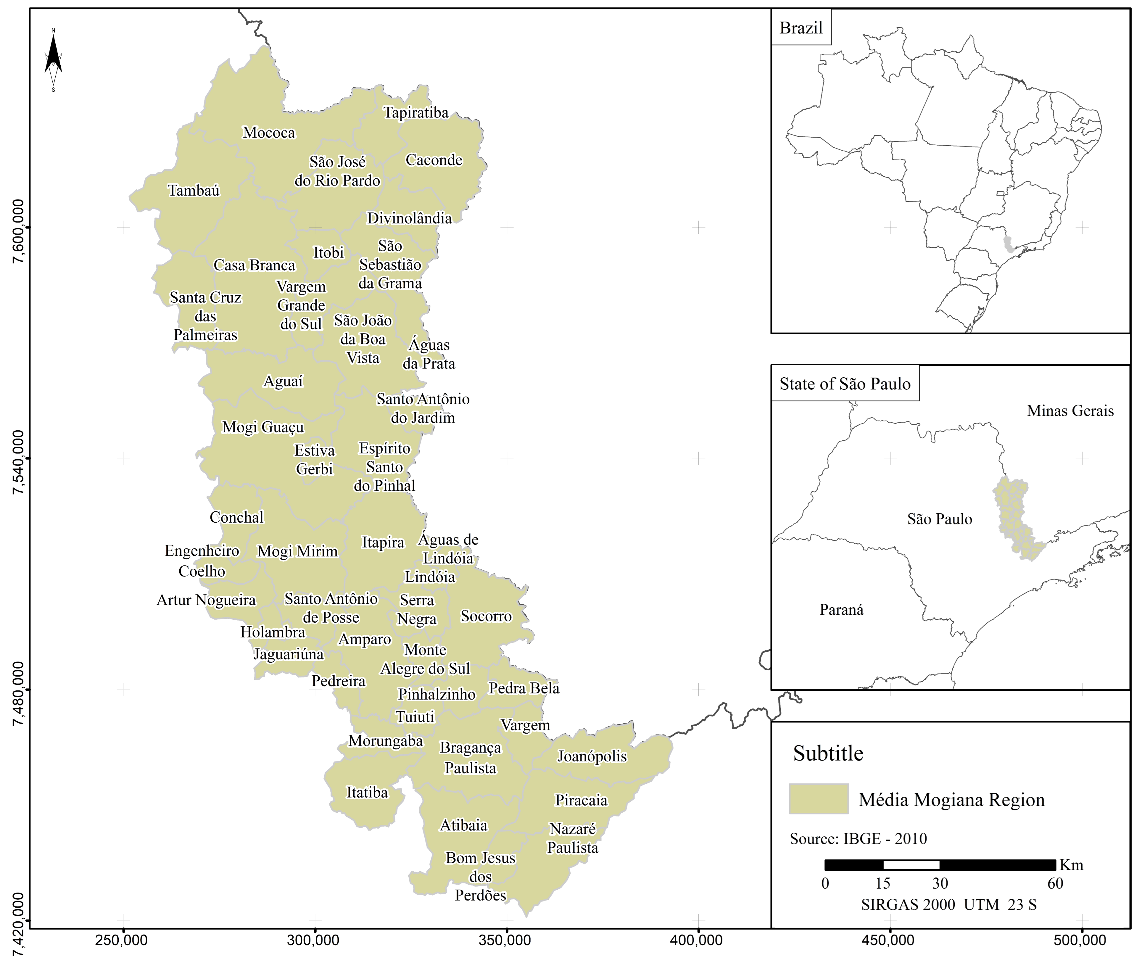
3.1. Study Area
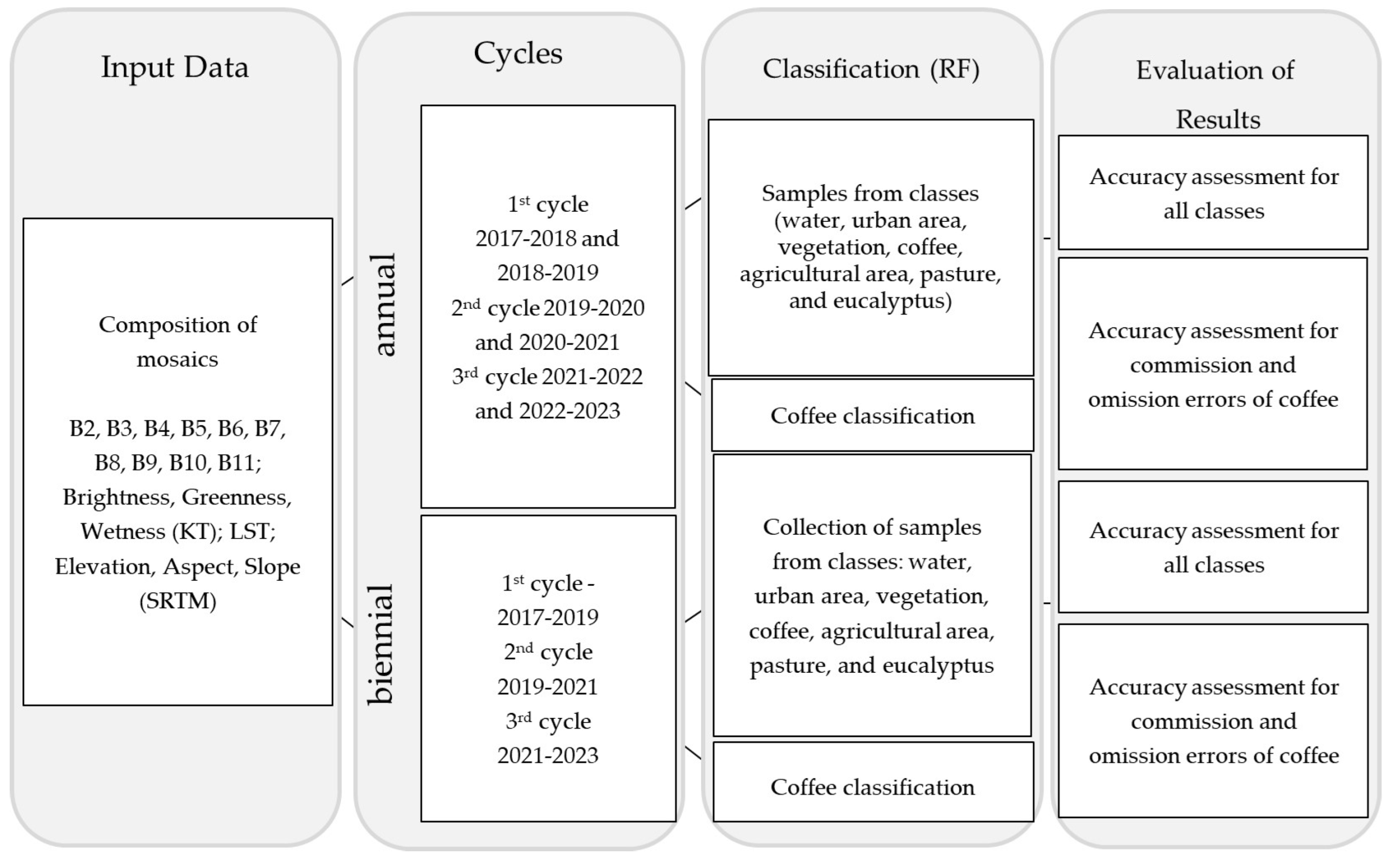
3.2. Methodology
- Mosaic 1: bands B2, B3, B4, B5, B6, B7, B8, B9, B10, B11, Brightness, Greenness, Wetness, LST, elevation, aspect, and slope;
- Mosaic 2: Brightness, Greenness, Wetness, LST, elevation, aspect, and slope.
3.3. Procedures and Data
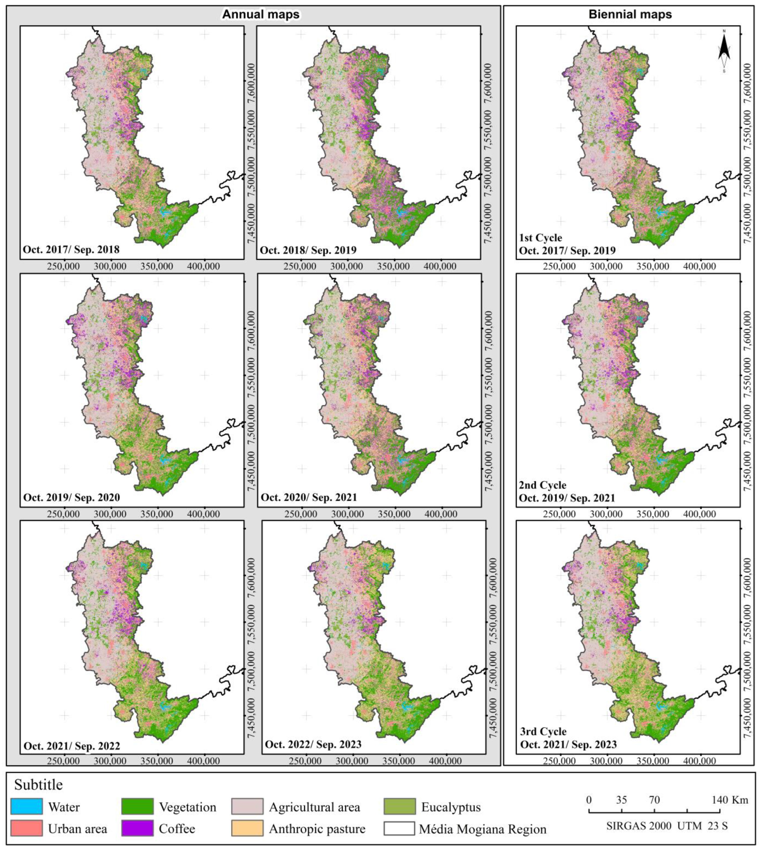
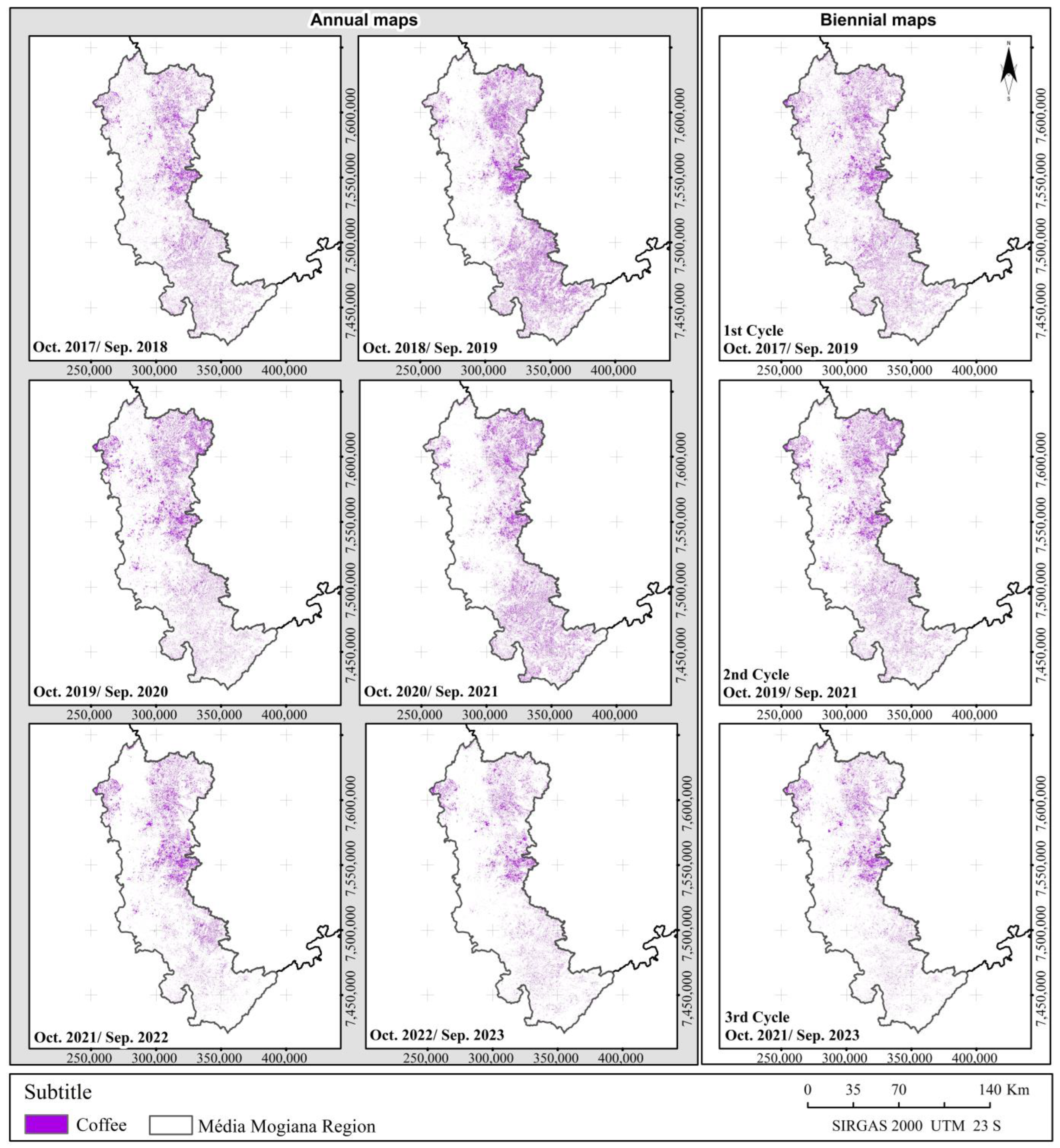
4. Results
5. Discussion
5.1. Data Evaluation
5.2. Map Evaluation
6. Conclusions
Author Contributions
Funding
Data Availability Statement
Acknowledgments
Conflicts of Interest
References
- Hunt, D.A.; Tabor, K.; Hewson, J.H.; Wood, M.A.; Reymondin, L.; Koenig, K.; Follett, F. Review of remote sensing methods to map coffee production systems. Remote Sens. 2020, 12, 2041. [Google Scholar] [CrossRef]
- Tamiminia, H.; Salehi, B.; Mahdianpari, M.; Quackenbush, L.; Adeli, S.; Brisco, B. Google Earth Engine for geo-big data applications: A meta-analysis and systematic review. ISPRS J. Photogramm. Remote Sens. 2020, 164, 152–170. [Google Scholar] [CrossRef]
- Chemura, A.; Mutanga, O. Developing detailed age-specific thematic maps for coffee (Coffea arabica L.) in heterogeneous agricultural landscapes using random forests applied on Landsat 8 multispectral sensor. Geocarto Int. 2017, 32, 759–776. [Google Scholar] [CrossRef]
- Kelley, L.C.; Pitcher, L.; Bacon, C. Using Google Earth Engine to Map Complex Shade-Grown Coffee Landscapes in Northern Nicaragua. Remote Sens. 2018, 10, 952. [Google Scholar] [CrossRef]
- Chemura, A.; Mutanga, O.; Odindi, J.; Kutywayo, D. Mapping spatial variability of foliar nitrogen in coffee (Coffea arabica L.) plantations with multispectral Sentinel-2 MSI data. ISPRS J. Photogramm. Remote Sens. 2018, 138, 1–11. [Google Scholar] [CrossRef]
- Cordero-Sancho, S.; Sader, S.A. Spectral analysis and classification accuracy of coffee crops using Landsat and a topographic-environmental model. Int. J. Remote Sens. 2007, 28, 1577–1593. [Google Scholar] [CrossRef]
- Ortega-Huerta, M.A.; Komar, O.; Price, K.P.; Ventura, H.J. Mapping Coffee plantations with Landsat imagery: An example from El Salvador. Int. J. Remote Sens. 2012, 33, 220–242. [Google Scholar] [CrossRef]
- Maskell, G.; Chemura, A.; Nguyen, H.; Gornott, C.; Mondal, P. Integration of Sentinel optical and radar data for mapping smallholder coffee production systems in Vietnam. Remote Sens. Environ. 2021, 266, 112709. [Google Scholar] [CrossRef]
- Mukashema, A.; Veldkamp, A.; Vrieling, A. Automated high-resolution mapping of coffee in Rwanda using an expert Bayesian network. Int. J. Appl. Earth Obs. Geoinf. 2014, 33, 331–340. [Google Scholar] [CrossRef]
- Gomez, C.; Mangeas, M.; Petit, M.; Corbane, C.; Hamon, P.; Hamon, S.; Despinoy, M. Use of high-resolution satellite imagery in an integrated model to predict the distribution of shade coffee tree hybrid zones. Remote Sens. Environ. 2010, 114, 2731–2744. [Google Scholar] [CrossRef]
- Kawakubo, F.S.; Perez Machado, R.P. Mapping coffee crops in southeastern Brazil using spectral mixture analysis and data mining classification. Int. J. Remote Sens. 2016, 37, 3414–3436. [Google Scholar] [CrossRef]
- Ango, T.G.; Hylander, K.; Börjeson, L. Processes of forest cover change since 1958 in the coffee-producing areas of Southwest Ethiopia. Land 2020, 9, 278. [Google Scholar] [CrossRef]
- Paula, A.D.; Cainzos, R.L.P.; Barros, O.N.F.; Ralisch, R. Analysis of multitemporal of the soil use and occupation between 1987 and 2004 in the northern urban expansion zone of Londrina-PR, using Remote Sensing (SR) and the Geographical Information System (GIS). Semin.-Cienc. Agrar. 2012, 33, 2877–2889. [Google Scholar] [CrossRef]
- Tridawati, A.; Wikantika, K.; Susantoro, T.M.; Harto, A.B.; Darmawan, S.; Yayusman, L.F.; Ghazali, M.F. Mapping the Distribution of Coffee Plantations from Multi-Resolution, Multi-Temporal, and Multi-Sensor Data Using a Random Forest Algorithm. Remote Sens. 2020, 12, 3933. [Google Scholar] [CrossRef]
- Ermida, S.L.; Soares, P.; Mantas, V.; Göttsche, F.M.; Trigo, I.F. Google Earth Engine Open-Source Code for Land Surface Temperature Estimation from the Landsat Series. Remote Sens. 2020, 12, 1471. [Google Scholar] [CrossRef]
- Sønsteby, A.; Roos, U.M.; Heide, O.M. Effects of biennial cropping and controlled shoot density on yield performance and fruit quality in red raspberry (Rubus idaeus L.). J. Hortic. Sci. Biotechnol. 2018, 94, 243–250. [Google Scholar] [CrossRef]
- Bernardes, T.; Moreira, M.A.; Adami, M.; Giarolla, A.; Rudorff, B.F.T. Monitoring Biennial Bearing Effect on Coffee Yield Using MODIS Remote Sensing Imagery. Remote Sens. 2012, 4, 2492–2509. [Google Scholar] [CrossRef]
- Tiwari, V.; Matin, M.A.; Qamer, F.M.; Ellenburg, W.L.; Bajracharya, B.; Vadrevu, K.; Yusafi, W. Wheat Area Mapping in Afghanistan Based on Optical and SAR Time-Series Images in Google Earth Engine Cloud Environment. Front. Environ. Sci. 2020, 8, 77. [Google Scholar] [CrossRef]
- Tian, F.; Wu, B.; Zeng, H.; Zhang, X.; Xu, J. Efficient Identification of Corn Cultivation Area with Multitemporal Synthetic Aperture Radar and Optical Images in the Google Earth Engine Cloud Platform. Remote Sens. 2019, 11, 629. [Google Scholar] [CrossRef]
- Rudiyanto, R.; Minasny, B.; Shah, R.M.; Soh, N.C.; Arif, C.; Setiawan, B.I. Automated Near-Real-Time Mapping and Monitoring of Rice Extent, Cropping Patterns, and Growth Stages in Southeast Asia Using Sentinel-1 Time Series on a Google Earth Engine Platform. Remote Sens. 2019, 11, 1666. [Google Scholar] [CrossRef]
- Jesus, J.; Santos, F.; Gomes, A.; Teodoro, A.C. Temporal analysis of the vineyard phenology from remote sensing data using Google Earth Engine. In Remote Sensing for Agriculture, Ecosystems, and Hydrology XXII; SPIE: Bellingham, WA, USA, 2020; Volume 11528, pp. 39–50. [Google Scholar]
- ICO—International Coffee Organization. Coffee Report and Outlook. Available online: https://icocoffee.org/documents/cy2022-23/Coffee_Report_and_Outlook_April_2023_-_ICO.pdf (accessed on 11 October 2023).
- Van Der Vossen, H.; Bertrand, B.; Charrier, A. Next generation variety development for sustainable production of arabica coffee (Coffea arabica L.): A review. Euphytica 2015, 204, 243–256. [Google Scholar] [CrossRef]
- Carvalho, C.H.S. Cultivares de Café: Origem, Características e Recomendações; Embrapa Café: Brasília, Brazil, 2008; 334p. [Google Scholar]
- Camargo, A.P.; Camargo, M.B.P. Definition and outline for the phenological phases of Arabic Coffee under Brazilian tropical conditions. Bragantia 2001, 60, 65–68. [Google Scholar] [CrossRef]
- CONAB—Companhia Nacional de Abastecimento. Boletim da Safra de Café. Available online: https://www.conab.gov.br/info-agro/safras/cafe/boletim-da-safra-de-cafe (accessed on 18 January 2024).
- Martello, M.; Molin, J.P.; Wei, M.C.F.; Canal Filho, R.; Nicoletti, J.V.M. Coffee-yield estimation using high-resolution time-series satellite images and machine learning. AgriEngineering 2022, 4, 888–902. [Google Scholar] [CrossRef]
- Chaves, M.E.D.; Picoli, M.C.A.; Sanches, I. Recent Applications of Landsat 8/OLI and Sentinel-2/MSI for Land Use and Land Cover Mapping: A Systematic Review. Remote Sens. 2020, 12, 3062. [Google Scholar] [CrossRef]
- Lambert, M.J.; Sibiry, P.C.; Blaes, X.; Baret, P.; Defourny, P. Estimating smallholder crops production at village level from Sentinel-2 time series in Mali’s cotton belt. Remote Sens. Environ. 2018, 216, 647–657. [Google Scholar] [CrossRef]
- Breiman, L. Random Forests. Mach. Learn. 2001, 45, 5–32. [Google Scholar] [CrossRef]
- Weiss, M.; Jacob, F.; Duveiller, G. Remote sensing for agricultural applications: A meta-review. Remote Sens. Environ. 2020, 236, 111402. [Google Scholar] [CrossRef]
- Mosomtai, G.; Odindi, J.; Abdel-Rahman, E.M.; Babin, R.; Fabrice, P.; Mutanga, O.; Landmann, T. Landscape fragmentation in coffee agroecological subzones in central Kenya: A multiscale remote sensing approach. J. Appl. Remote Sens. 2020, 14, 044513. [Google Scholar] [CrossRef]
- Bolívar-Santamaría, S.; Reu, B. Detection and characterization of agroforestry systems in the Colombian Andes using sentinel-2 imagery. Agrofor. Syst. 2021, 95, 499–514. [Google Scholar] [CrossRef]
- Kauth, R.J.; Thomas, G.S. The Tasseled Cap—A graphic description of the spectral-temporal development of agricultural crops as seen by Landsat. In LARS Symposia; Purdue University: West Lafayette, IN, USA, 1976; p. 159. [Google Scholar]
- Benefoh, D.T.; Villamor, G.B.; van Noordwijk, M.; Borgemeister, C.; Asante, W.A.; Asubonteng, K.O. Assessing land-use typologies and change intensities in a structurally complex Ghanaian cocoa landscape. Appl. Geogr. 2018, 99, 109–119. [Google Scholar] [CrossRef]
- Moreira, M.A.; Adam, M.; Rudorff, B.F.T. Spectral and temporal behavior analysis of coffee crop in Landsat images. Pesqui. Agropecu. Bras. 2004, 39, 223–231. [Google Scholar] [CrossRef]
- Martinez-Verduzco, G.C.; Galeana-Pizana, J.M.; Cruz-Bello, G.M. Coupling Community Mapping, and supervised classification to discriminate Shade coffee from Natural vegetation. Appl. Geogr. 2012, 34, 1–9. [Google Scholar] [CrossRef]
- Olofsson, P.; Foody, G.M.; Herold, M.; Stehman, S.V.; Woodcock, C.E.; Wulder, M.A. Good practices for estimating area and assessing the accuracy of land change. Remote Sens. Environ. 2014, 148, 42–57. [Google Scholar] [CrossRef]
- Thao, N.T.T.; Khoi, D.N.; Denis, A.; Viet, L.V.; Wellens, J.; Tychon, B. Early prediction of coffee yield in the central highlands of Vietnam using a statistical approach and satellite remote sensing vegetation biophysical variables. Remote Sens. 2022, 14, 2975. [Google Scholar] [CrossRef]
- Bunn, C.; Laderach, P.; Ovalle Rivera, O.; Kirschke, D. A bitter cup: Climate change profile of global production of Arabica and Robusta coffee. Clim. Change 2015, 129, 89–101. [Google Scholar] [CrossRef]
- Niazmardi, S.; Homayouni, S.; Safari, A.; McNairn, H.; Shang, J.; Beckett, K. Histogram-based spatio-temporal feature classification of vegetation indices time-series for crop mapping. Int. J. Appl. Earth Obs. Geoinf. 2018, 72, 34–41. [Google Scholar] [CrossRef]
- Funk, C.; Peterson, P.; Landsfeld, M.; Pedreros, D.; Verdin, J.; Rowland, J.; Michaelsen, J. The climate hazards infrared precipitation with stations—A new environmental record for monitoring extremes. Sci. Data 2015, 2, 150066. [Google Scholar] [CrossRef]
- Bourgoin, C.; Oszwald, J.; Bourgoin, J.; Gond, V.; Blanc, L.; Dessard, H.; Phan, T.V.; Sist, P.; Läderach, P.; Reymondin, L. Assessing the ecological vulnerability of forest landscape to agricultural frontier expansion in the Central Highlands of Vietnam. Int. J. Appl. Earth Obs. Geoinf. 2020, 84, 101958. [Google Scholar] [CrossRef]
- Reiche, J.; Lucas, R.; Mitchell, A.L.; Verbesselt, J.; Hoekman, D.H.; Haarpaintner, J.; Kellndorfer, J.M.; Rosenqvist, A.; Lehmann, E.A.; Woodcock, C.E.; et al. Combining satellite data for better tropical forest monitoring. Nat. Clim. Change 2016, 6, 120–122. [Google Scholar] [CrossRef]
- Li, J.; Roy, D.P. A global analysis of Sentinel-2A, Sentinel-2B and Landsat-8 data revisit intervals and implications for terrestrial monitoring. Remote Sens. 2017, 9, 902. [Google Scholar] [CrossRef]
- Silva, W.F.; Rudor, B.F.T.; Formaggio, A.R.; Paradella, W.R.; Mura, J.C. Discrimination of agricultural crops in a tropical semi-arid region of Brazil based on L-band polarimetric airborne SAR data. ISPRS J. Photogramm. Remote Sens. 2009, 64, 458–463. [Google Scholar] [CrossRef]
- Zeng, L.; Wardlow, B.D.; Xiang, D.; Hu, S.; Li, D. A Review of Vegetation Phenological Metrics Extraction Using Time-Series, Multispectral Satellite Data. Remote Sens. Environ. 2020, 237, 111511. [Google Scholar] [CrossRef]
- Numbisi, F.N.; Van Coillie, F.M.B.; Wulf, R. Delineation of Cocoa Agroforests Using Multiseason Sentinel-1 SAR Images: A Low Grey Level Range Reduces Uncertainties in GLCM Texture-Based Mapping. ISPRS Int. J. Geo-Inf. 2019, 8, 179. [Google Scholar] [CrossRef]
- Moraiti, N.; Mullissa, A.; Rahn, E.; Sassen, M.; Reiche, J. Critical Assessment of Cocoa Classification with Limited Reference Data: A Study in Côte d’Ivoire and Ghana Using Sentinel-2 and Random Forest Model. Remote Sens. 2024, 16, 598. [Google Scholar] [CrossRef]
- Kouadio, L.; Tixier, P.; Byrareddy, V.; Marcussen, T.; Mushtaq, S.; Rapidel, B.; Stone, R. Performance of a process-based model for predicting robusta coffee yield at the regional scale in Vietnam. Ecol. Model. 2021, 443, 109469. [Google Scholar] [CrossRef]
- Ovalle-Rivera, O.; Van Oijen, M.; Läderach, P.; Roupsard, O.; de Melo Virginio Filho, E.; Barrios, M.; Rapidel, B. Assessing the accuracy and robustness of a process-based model for coffee agroforestry systems in Central America. Agrofor. Syst. 2020, 94, 2033–2051. [Google Scholar] [CrossRef]
- Zanella, M.A.; Martins, R.N.; da Silva, F.M.; Carvalho, L.C.C.; de Carvalho Alves, M.; Rosas, J.T.F. Coffee yield prediction using high-resolution satellite imagery and crop nutritional status in Southeast Brazil. Remote Sens. Appl. Soc. Environ. 2024, 33, 101092. [Google Scholar] [CrossRef]
- Brunsell, N.A.; Pontes, P.P.B.; Lamparelli, R.A.C. Remotely sensed phenology of coffee and its relationship to yield. GIScience Remote Sens. 2009, 46, 289–304. [Google Scholar] [CrossRef]






| Cycles | Year | Biennial Period | Bags Harvested (Millions) | Climate Observations |
|---|---|---|---|---|
| 1st cycle | Annual 2017–2018 | Positive | 6.2 | Good weather conditions |
| Annual 2018–2019 | Negative | 4.3 | Standard weather conditions | |
| Biennial 2017–2019 | - | 10.5 | - | |
| 2nd cycle | Annual 2019–2020 | Positive | 6.2 | Good weather conditions |
| Annual 2020–2021 | Negative | 4.0 | Bad weather conditions (droughts and frosts) | |
| Biennial 2019–2021 | - | 10.2 | - | |
| 3rd cycle | Annual 2021–2022 | Positive | 3.9 | Bad weather conditions |
| Annual 2022–2023 | Negative | 5.0 | Recovery from the previous harvest | |
| Biennial 2021–2023 | - | 8.9 | - |
| Cycles | Year | Period | Biennial |
|---|---|---|---|
| 1st cycle | Annual 2017–2018 | 1 October 2017 a 30 September 2018 | Positive |
| Annual 2018–2019 | 1 October 2018 a 30 September 2019 | Negative | |
| Biennial 2017–2019 | 1 October 2017 a 30 September 2019 | - | |
| 2nd cycle | Annual 2019–2020 | 1 October 2019 a 30 September 2020 | Positive |
| Annual 2020–2021 | 1 October 2020 a 30 September 2021 | Negative | |
| Biennial 2019–2021 | 1 October 2019 a 30 September 2021 | - | |
| 3rd cycle | Annual 2021–2022 | 1 October 2021 a 30 September 2022 | Positive |
| Annual 2022–2023 | 1 October 2022 a 30 September 2023 | Negative | |
| Biennial 2021–2023 | 1 October 2021 a 30 September 2023 | - |
| Class | Definition |
|---|---|
| Agricultural area | Areas with diverse crops, such as perennials (orange trees and vines) and seasonal crops (corn and sugar cane), as well as areas destined for agriculture, were collected (109 samples). |
| Eucalyptus | Areas of eucalyptus plantations (separate class for distinction from the coffee class) (70 samples). |
| Urban area | Urban areas, clusters of rural houses, and other buildings (75 samples). |
| Vegetation | Areas of preserved and/or native vegetation (121 samples). |
| Coffee | Coffee plantation areas (108 samples). |
| Pasture | Areas of pastures without agricultural uses during the analyzed period (105 samples). |
| Water | Water concentration areas (rivers and lakes) (70 samples). |
| Cycles | 1st Cycle | 2nd Cycle | 3rd Cycle | ||||||
|---|---|---|---|---|---|---|---|---|---|
| Year | Annual 2017–2018 | Annual 2018–2019 | Biennial 2017–2019 | Annual 2019–2020 | Annual 2020–2021 | Biennial 2019–2021 | Annual 2021–2022 | Annual 2022–2023 | Biennial 2021–2023 |
| Mosaic 1 | 85.3 | 85.4 | 88.8 | 83.8 | 81 | 83.7 | 80.8 | 81 | 81 |
| Mosaic 2 | 79.6 | 81.3 | 85.5 | 77.3 | 80.3 | 78.1 | 74.8 | 74.5 | 74.2 |
| Cycles | 1st Cycle | 2nd Cycle | 3rd Cycle | ||||||
|---|---|---|---|---|---|---|---|---|---|
| Year | Annual 2017–2018 | Annual 2018–2019 | Biennial 2017–2019 | Annual 2019–2020 | Annual 2020–2021 | Biennial 2019–2021 | Annual 2021–2022 | Annual 2022–2023 | Biennial 2021–2023 |
| Mosaic 1 | 35.1 | 34.7 | 31.8 | 33.5 | 38.6 | 31.7 | 34.6 | 38.8 | 39.9 |
| Mosaic 2 | 45.3 | 42.7 | 43.2 | 41.5 | 51.2 | 46.2 | 52.5 | 50.8 | 56.5 |
| Cycles | 1st Cycle | 2nd Cycle | 3rd Cycle | ||||||
|---|---|---|---|---|---|---|---|---|---|
| Year | Annual 2017–2018 | Annual 2018–2019 | Biennial 2017–2019 | Annual 2019–2020 | Annual 2020–2021 | Biennial 2019–2021 | Annual 2021–2022 | Annual 2022–2023 | Biennial 2021–2023 |
| Mosaic 1 | 25.2 | 23.8 | 22 | 30.1 | 32.2 | 25.8 | 43.7 | 32.2 | 45.3 |
| Mosaic 2 | 50.9 | 35.1 | 36.7 | 26.4 | 38.5 | 25.7 | 46.4 | 35.4 | 52.4 |
| Cycles | Year | General Hits (All Classes) | Commission Errors (Coffee) | Omission Errors (Coffee) |
|---|---|---|---|---|
| 1st cycle | Annual 2017–2018 | 85.3 | 35.1 | 25.2 |
| Annual 2018–2019 | 85.4 | 34.7 | 23.8 | |
| Biennial 2017–2019 | 88.8 | 31.8 | 22.0 | |
| 2nd cycle | Annual 2019–2020 | 83.8 | 33.5 | 30.1 |
| Annual 2020–2021 | 81.0 | 38.6 | 32.2 | |
| Biennial 2019–2021 | 83.7 | 31.7 | 25.8 | |
| 3rd cycle | Annual 2021–2022 | 80.8 | 34.6 | 43.7 |
| Annual 2022–2023 | 81.0 | 38.8 | 32.2 | |
| Biennial 2021–2023 | 81.0 | 39.9 | 45.3 |
Disclaimer/Publisher’s Note: The statements, opinions and data contained in all publications are solely those of the individual author(s) and contributor(s) and not of MDPI and/or the editor(s). MDPI and/or the editor(s) disclaim responsibility for any injury to people or property resulting from any ideas, methods, instructions or products referred to in the content. |
© 2024 by the authors. Licensee MDPI, Basel, Switzerland. This article is an open access article distributed under the terms and conditions of the Creative Commons Attribution (CC BY) license (https://creativecommons.org/licenses/by/4.0/).
Share and Cite
Manoel, M.C.; Rosa, M.R.; Queiroz, A.P.d. Analysis of the Biennial Productivity of Arabica Coffee with Google Earth Engine in the Northeast Region of São Paulo, Brazil. Remote Sens. 2024, 16, 3833. https://doi.org/10.3390/rs16203833
Manoel MC, Rosa MR, Queiroz APd. Analysis of the Biennial Productivity of Arabica Coffee with Google Earth Engine in the Northeast Region of São Paulo, Brazil. Remote Sensing. 2024; 16(20):3833. https://doi.org/10.3390/rs16203833
Chicago/Turabian StyleManoel, Maria Cecilia, Marcos Reis Rosa, and Alfredo Pereira de Queiroz. 2024. "Analysis of the Biennial Productivity of Arabica Coffee with Google Earth Engine in the Northeast Region of São Paulo, Brazil" Remote Sensing 16, no. 20: 3833. https://doi.org/10.3390/rs16203833
APA StyleManoel, M. C., Rosa, M. R., & Queiroz, A. P. d. (2024). Analysis of the Biennial Productivity of Arabica Coffee with Google Earth Engine in the Northeast Region of São Paulo, Brazil. Remote Sensing, 16(20), 3833. https://doi.org/10.3390/rs16203833


