Weighted Fusion Method of Marine Gravity Field Model Based on Water Depth Segmentation
Abstract
1. Introduction
2. Methodology
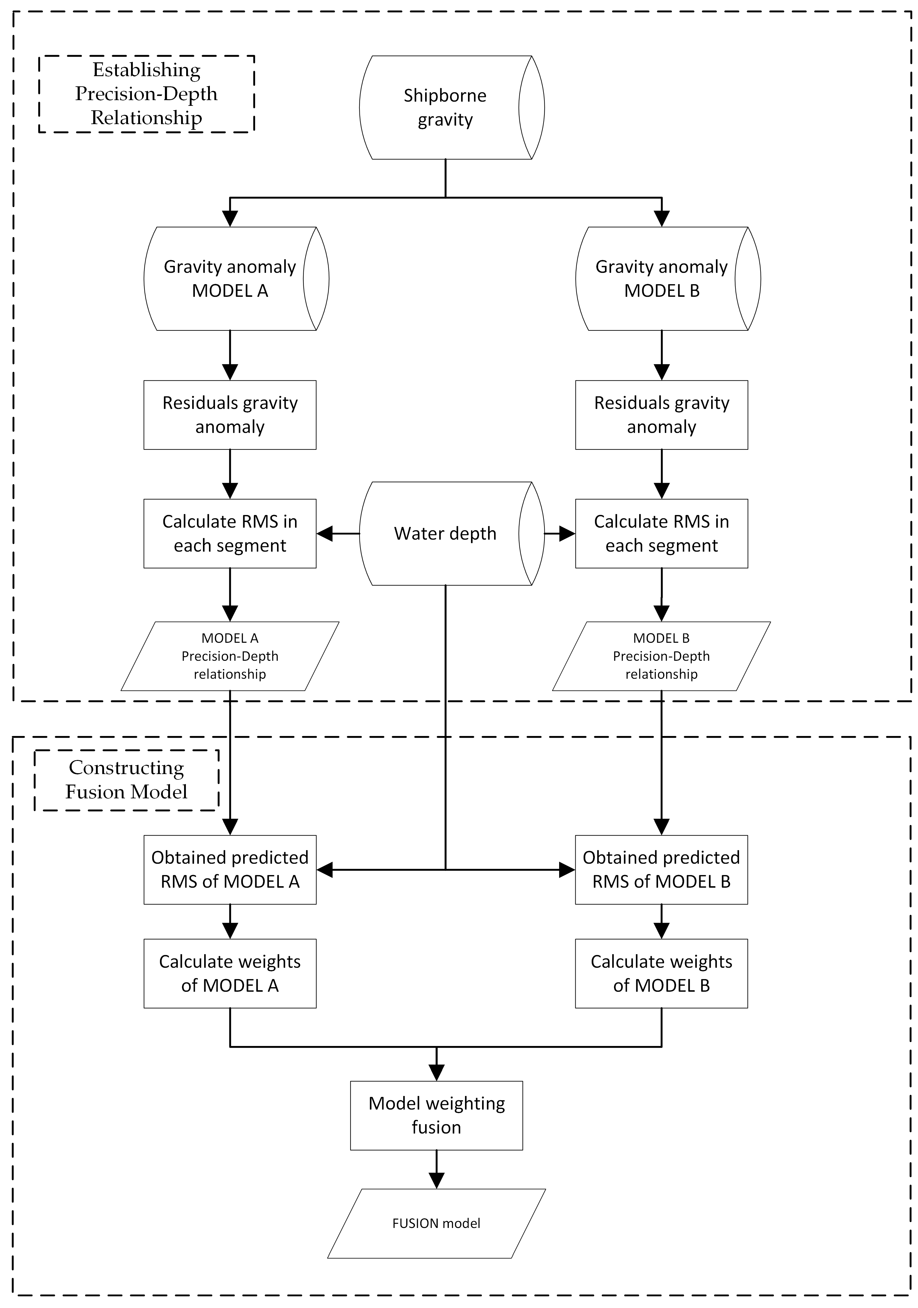
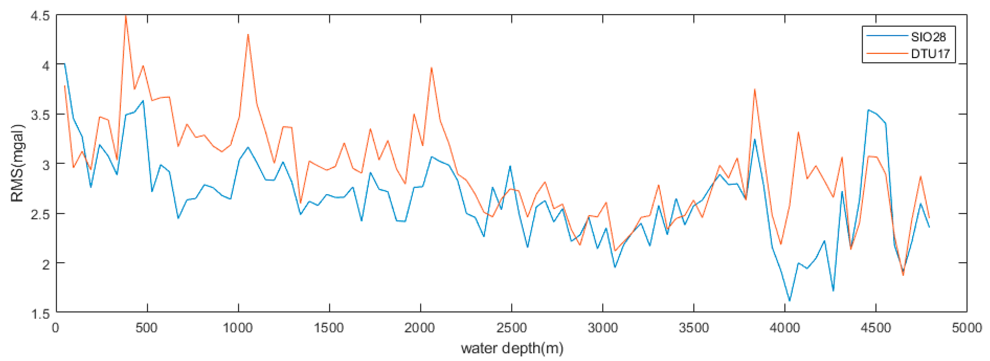
2.1. Establishing Precision–Depth Relationship
2.2. Constructing Fusion Model
3. Application
3.1. Study Area
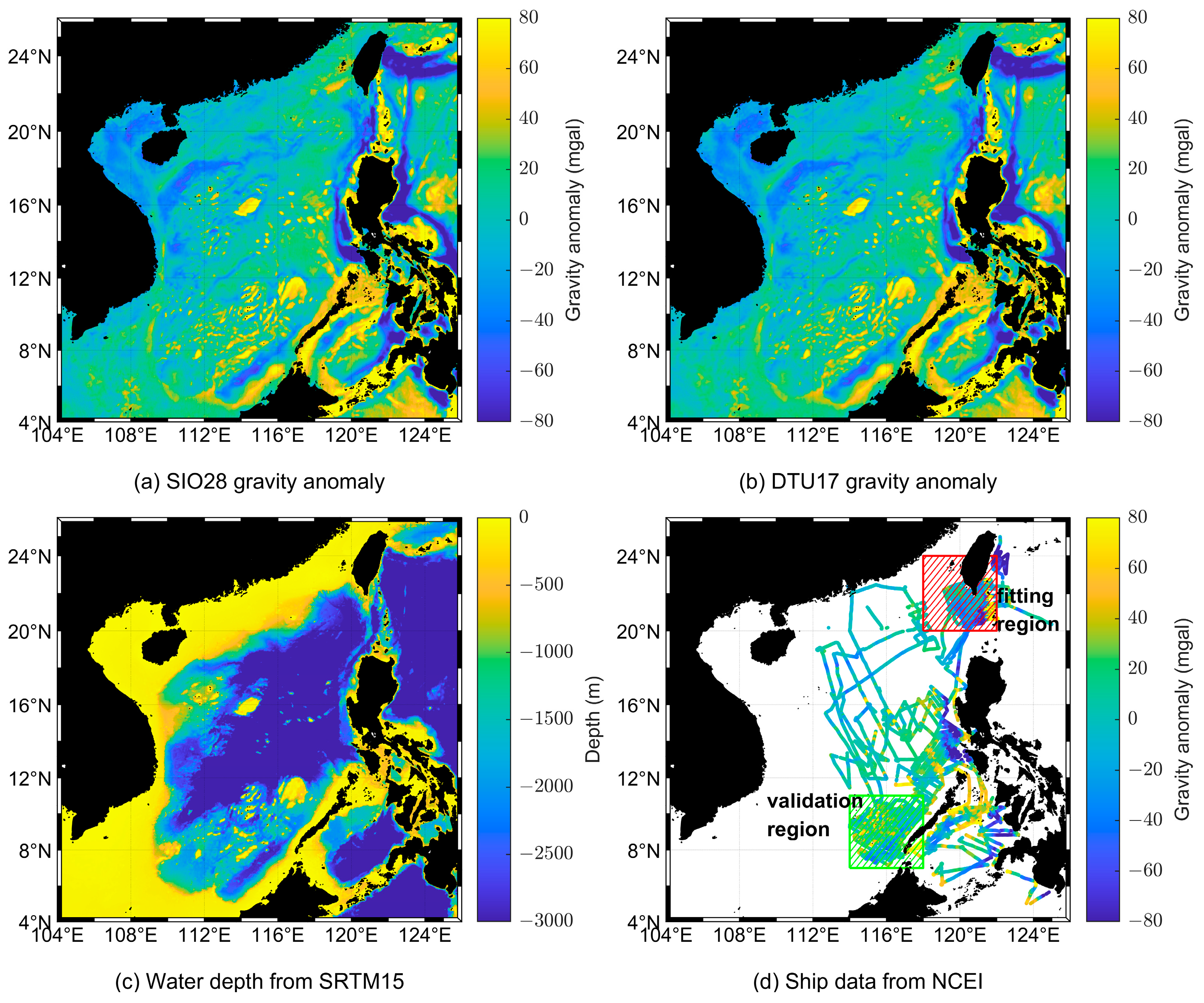
3.2. Gravity Field and Bathymetric Model
3.3. Shipborne Gravity Data and Preprocessing
3.4. The Fusion Gravity Field Model FUSION Built in SCS
4. Results and Discussion
- (1)
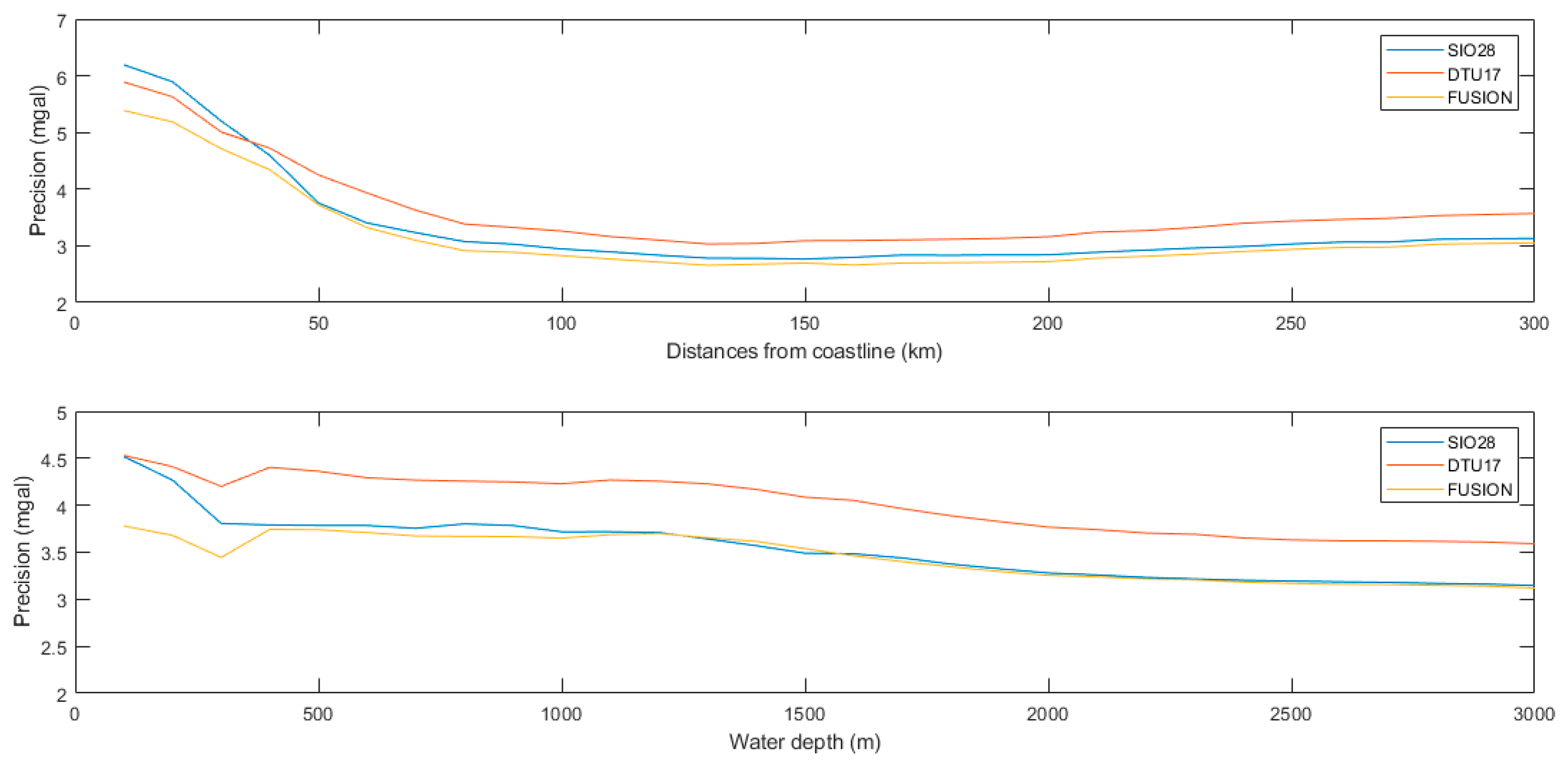
- The region where the fusion model is similar to DTU17’s gravity field model is concentrated in shallow reefs and nearshore areas. In these marine regions, gravity field model inversion with SSH is less affected by high-frequency noise on the sea surface to achieve higher weight.
- (2)
- The region where the fusion model is similar to the SIO28 gravity field model is mainly concentrated in deep-sea areas. Additionally, rapid changes at island–reef boundaries and seafloor topography are more pronounced in these areas. This represents that gravity field model inversion with DOV performs well in describing the details of undersea terrain changes in regions with low sea surface complexity.
- (1)
- The high-frequency component of the SIO28 model shows the change in the Nansha Trough in the southwest of the region and the west Palawan oblique thrust fault on the west side of Palawan Island, but there still exists high-frequency components in other flat areas, which are likely the noise amplified by DOV;
- (2)
- The DTU17 model has a high degree of agreement in the Reed Tablemount (at the northeast corner of the figure) and the Nansha Islands and reefs (at the upper left half of the figure) with the high-frequency component of the SRTM15 seabed terrain model shown in Figure 7d, which means that the DTU17 model retained the trusted detail changes in these areas;
- (3)
- Figure 7c shows that the fusion model retains the high-frequency detail of the shallow water area in the high-frequency component, while suppressing the high-frequency noise that appears in open waters, thereby integrating the advantages of both models.
5. Conclusions
Author Contributions
Funding
Data Availability Statement
Acknowledgments
Conflicts of Interest
References
- Tozer, B.; Sandwell, D.T.; Smith, W.H.F.; Olson, C.; Beale, J.R.; Wessel, P. Global Bathymetry and Topography at 15 Arc Sec: SRTM15+. Earth Space Sci. 2019, 6, 1847–1864. [Google Scholar] [CrossRef]
- Fan, D.; Li, S.; Feng, J.; Sun, Y.; Xu, Z.; Huang, Z. A New Global Bathymetry Model: STO_IEU2020. Remote Sens. 2022, 14, 5744. [Google Scholar] [CrossRef]
- Zhou, S.; Guo, J.; Zhang, H.; Jia, Y.; Sun, H.; Liu, X.; An, D. SDUST2023BCO: A global seafloor model determined from multi-layer perceptron neural network using multi-source differential marine geodetic data. Earth Syst. Sci. Data Discuss. 2024, 2024, 1–21. [Google Scholar] [CrossRef]
- Garcia, E.S.M.; Sandwell, D.T.; Bassett, D. Outer trench slope flexure and faulting at Pacific basin subduction zones. Geophys. J. Int. 2019, 218, 708–728. [Google Scholar] [CrossRef]
- Hwang, C.; Chang, E.T.Y. Seafloor secrets revealed. Science 2014, 346, 32–33. [Google Scholar] [CrossRef]
- Zhao, X.; Zheng, W.; Xu, K.; Zhang, H.B. Optimizing the Matching Area for Underwater Gravity Matching Navigation Based on a New Gravity Field Feature Parameters Selection Method. Remote Sens. 2024, 16, 2202. [Google Scholar] [CrossRef]
- Liu, Q.; Xu, K.; Jiang, M.; Wang, J. Preliminary marine gravity field from HY-2A/GM altimeter data. Acta Oceanolog. Sin. 2020, 39, 127–134. [Google Scholar] [CrossRef]
- Zingerle, P.; Pail, R.; Gruber, T.; Oikonomidou, X. The combined global gravity field model XGM2019e. J. Geod. 2020, 94, 66. [Google Scholar] [CrossRef]
- Liu, Q.; Xu, K.; Jiang, M. A New DOV Gridding Method and Its Application in Marine Gravity Recovery. IEEE Geosci. Remote Sens. Lett. 2022, 19, 8025205. [Google Scholar] [CrossRef]
- Zhu, C.; Yang, L.; Bian, H.; Li, H.; Guo, J.; Liu, N.; Lin, L. Recovering Gravity from Satellite Altimetry Data Using Deep Learning Network. IEEE Trans. Geosci. Remote Sens. 2023, 61, 5911311. [Google Scholar] [CrossRef]
- Li, Z.; Guo, J.; Zhu, C.; Liu, X.; Hwang, C.; Lebedev, S.; Chang, X.; Soloviev, A.; Sun, H. The SDUST2022GRA global marine gravity anomalies recovered from radar and laser altimeter data: Contribution of ICESat-2 laser altimetry. Earth Syst. Sci. Data 2024, 16, 4119–4135. [Google Scholar] [CrossRef]
- Zhang, S.; Chen, X.; Zhou, R.; Jia, Y. A new global marine gravity model NSOAS24 derived from multi-satellite sea surface slopes. EGUsphere 2024, 2024, 1–31. [Google Scholar] [CrossRef]
- Sandwell, D.T.; Harper, H.; Tozer, B.; Smith, W.H.F. Gravity field recovery from geodetic altimeter missions. Adv. Space Res. 2021, 68, 1059–1072. [Google Scholar] [CrossRef]
- Andersen, O.; Zhang, S.; Sandwell, D.; Gerald, D.; Smith, W.; Abulaitijiang, A. The Unique Role of the Jason Geodetic Missions for High Resolution Gravity Field and Mean Sea Surface Modelling. Remote Sens. 2021, 13, 646. [Google Scholar] [CrossRef]
- Abdallah, M.; Abd El Ghany, R.; Rabah, M.; Zaki, A. Comparison of recently released satellite altimetric gravity models with shipborne gravity over the Red Sea. Egypt. J. Remote Sens. Space Sci. 2022, 25, 579–592. [Google Scholar] [CrossRef]
- Hao, R.; Wan, X.; Annan, R.F. Enhanced Short-Wavelength Marine Gravity Anomaly Using Depth Data. IEEE Trans. Geosci. Remote Sens. 2023, 61, 5903109. [Google Scholar] [CrossRef]
- Li, Q.; Bao, F.; Wang, Y. Accuracy Evaluation of Altimeter-Derived Gravity Field Models in Offshore and Coastal Regions of China. Front. Earth Sci. 2021, 9, 722019. [Google Scholar] [CrossRef]
- Zhu, C.; Guo, J.; Yuan, J.; Li, Z.; Liu, X.; Gao, J. SDUST2021GRA: Global marine gravity anomaly model recovered from Ka-band and Ku-band satellite altimeter data. Earth Syst. Sci. Data 2022, 14, 4589–4606. [Google Scholar] [CrossRef]
- Li, Z.; Guo, J.; Ji, B.; Wan, X.; Zhang, S. A Review of Marine Gravity Field Recovery from Satellite Altimetry. Remote Sens. 2022, 14, 4790. [Google Scholar] [CrossRef]
- Pavlis, N.K.; Holmes, S.A.; Kenyon, S.C.; Factor, J.K. The Development and Evaluation of the Earth Gravitational Model 2008 (EGM2008) (vol 117, B04406, 2012). J. Geophys. Res. Solid Earth 2013, 118, 2633. [Google Scholar] [CrossRef]
- Zhang, M.; Yuan, H. Pauta standard and abnormal value eliminate. J. Zhengzhou Univ. Eng. Sci. 1997, 18, 88–92. [Google Scholar]
- Hwang, C.; Parsons, B. Gravity Anomalies Derived From Seasat, Geosat, ERS-1 and Topex/Poseidon Altimetry and Ship Gravity A Case-Study over The Reykjanes Ridge. Geophys. J. Int. 1995, 122, 551–568. [Google Scholar] [CrossRef]
- Zhang, S.; Chen, Z.; Wang, Q.; Liu, J.; Zhang, P. The Anomaly Feature Extraction of Mobile Gravity in the Sichuan-Yunnan Region Using Wavelet Transform Method—The Case Study of the Ludian MS6.5 and Jinggu MS6.6 Earthquakes in 2014. J. Geodesy. Geodyn. 2020, 40, 87–93. [Google Scholar]
- Tan, P. The multi-source gravity field fusion method and its application to the South China Sea. Geophys. Geochem. Explor. 2018, 42, 104–110. [Google Scholar]
- Yang, W.; Shi, Z.; Hou, Z. Discrete Wavelet Transform for Multiple Decomposition of Gravity Anomalies. Chin. J. Geophys. 2001, 44, 529–537. [Google Scholar]
- Wessel, P.; Luis, J.F.; Uieda, L.; Scharroo, R.; Wobbe, F.; Smith, W.H.F.; Tian, D. The Generic Mapping Tools Version 6. Geochem. Geophys. Geosyst. 2019, 20, 5556–5564. [Google Scholar] [CrossRef]


| GEOSAT | ERS-1 | JASON-1/2 | CRYOSAT-2 | SRIL | |
|---|---|---|---|---|---|
| SIO28 | 18 | 12 | 14/12 | ~96 | ~32 |
| DTU17 | 18 | 12 | 14/0 | ~84 | ~12 |
| MAX | MIN | MEAN | STD | RMS | |
|---|---|---|---|---|---|
| BEFORE | 577.88 | −518.44 | −1.25 | 44.18 | 44.19 |
| AFTER | 11.39 | −20.04 | −0.21 | 3.88 | 3.88 |
| MODEL | MAX | MIN | MEAN | STD | RMS | |
|---|---|---|---|---|---|---|
| Overall South China Sea | SIO28 | 22.13 | −23.30 | 0.07 | 3.55 | 3.55 |
| DTU17 | 40.82 | −27.59 | 0.20 | 4.02 | 4.02 | |
| SDUST2022 | 23.64 | −32.17 | 0.28 | 3.75 | 3.76 | |
| NSOAS24 | 23.59 | −27.48 | 0.01 | 3.71 | 3.71 | |
| XGM2019 | 29.87 | −42.30 | 0.23 | 4.67 | 4.68 | |
| FUSION | 23.18 | −25.87 | 0.12 | 3.47 | 3.47 | |
| Nearshore (DIST ≤ 20 km) | SIO28 | 22.13 | −23.30 | 0.35 | 6.48 | 6.49 |
| DTU17 | 40.82 | −27.59 | 1.86 | 7.50 | 7.73 | |
| SDUST2022 | 23.64 | −32.17 | 1.86 | 6.99 | 7.23 | |
| NSOAS24 | 23.59 | −27.48 | 0.45 | 6.46 | 6.47 | |
| XGM2019 | 29.71 | −42.30 | 1.78 | 9.05 | 9.22 | |
| FUSION | 23.18 | −25.87 | 1.06 | 5.67 | 5.77 | |
| Shallow Water (Depth ≤ 100 m) | SIO28 | 22.13 | −20.80 | 0.88 | 5.29 | 5.37 |
| DTU17 | 21.80 | −21.33 | 0.37 | 4.56 | 4.58 | |
| SDUST2022 | 23.47 | −18.10 | 1.07 | 5.05 | 5.16 | |
| NSOAS24 | 22.27 | −16.14 | 1.11 | 4.63 | 4.76 | |
| XGM2019 | 25.41 | −26.62 | 1.04 | 5.81 | 5.90 | |
| FUSION | 20.61 | −16.17 | 0.63 | 4.01 | 4.06 |
| MODEL | MAX | MIN | MEAN | STD | RMS | |
|---|---|---|---|---|---|---|
| Overall Nansha Area | SIO28 | 17.29 | −15.99 | 0.43 | 3.14 | 3.17 |
| DTU17 | 21.14 | −20.25 | 0.40 | 3.58 | 3.60 | |
| FUSION | 16.56 | −14.91 | 0.42 | 3.12 | 3.15 | |
| Nearshore (DIST ≤ 20 km) | SIO28 | 13.73 | −8.94 | 1.89 | 5.20 | 5.53 |
| DTU17 | 21.14 | −8.77 | 1.87 | 5.01 | 5.34 | |
| FUSION | 16.45 | −7.54 | 1.95 | 4.71 | 5.10 | |
| Shallow Water (Depth ≤ 100 m) | SIO28 | 13.73 | −11.47 | 1.19 | 4.52 | 4.67 |
| DTU17 | 21.14 | −17.08 | −0.32 | 4.53 | 4.54 | |
| FUSION | 16.77 | −10.90 | 1.31 | 3.78 | 4.01 |
Disclaimer/Publisher’s Note: The statements, opinions and data contained in all publications are solely those of the individual author(s) and contributor(s) and not of MDPI and/or the editor(s). MDPI and/or the editor(s) disclaim responsibility for any injury to people or property resulting from any ideas, methods, instructions or products referred to in the content. |
© 2024 by the authors. Licensee MDPI, Basel, Switzerland. This article is an open access article distributed under the terms and conditions of the Creative Commons Attribution (CC BY) license (https://creativecommons.org/licenses/by/4.0/).
Share and Cite
Chen, Z.; Liu, Q.; Xu, K.; Liu, X. Weighted Fusion Method of Marine Gravity Field Model Based on Water Depth Segmentation. Remote Sens. 2024, 16, 4107. https://doi.org/10.3390/rs16214107
Chen Z, Liu Q, Xu K, Liu X. Weighted Fusion Method of Marine Gravity Field Model Based on Water Depth Segmentation. Remote Sensing. 2024; 16(21):4107. https://doi.org/10.3390/rs16214107
Chicago/Turabian StyleChen, Zhaoyu, Qiankun Liu, Ke Xu, and Xiaoyang Liu. 2024. "Weighted Fusion Method of Marine Gravity Field Model Based on Water Depth Segmentation" Remote Sensing 16, no. 21: 4107. https://doi.org/10.3390/rs16214107
APA StyleChen, Z., Liu, Q., Xu, K., & Liu, X. (2024). Weighted Fusion Method of Marine Gravity Field Model Based on Water Depth Segmentation. Remote Sensing, 16(21), 4107. https://doi.org/10.3390/rs16214107


