
A Method for Retrieving Cloud Microphysical Properties Using Combined Measurement of Millimeter-Wave Radar and Lidar

 ,
,
Abstract
:1. Introduction
2. Materials and Methods
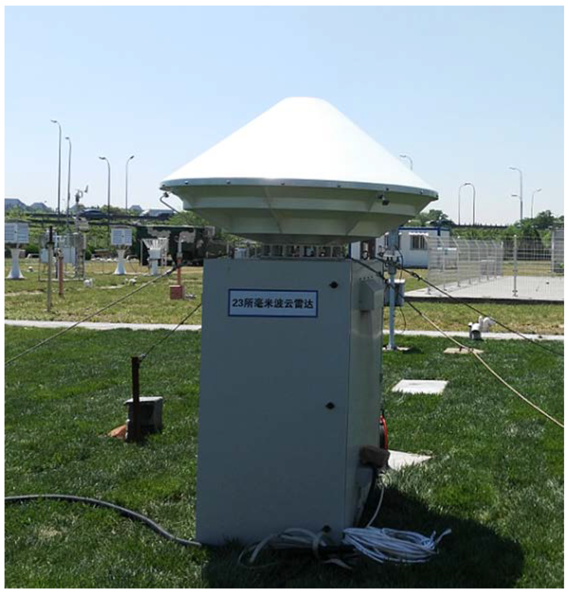
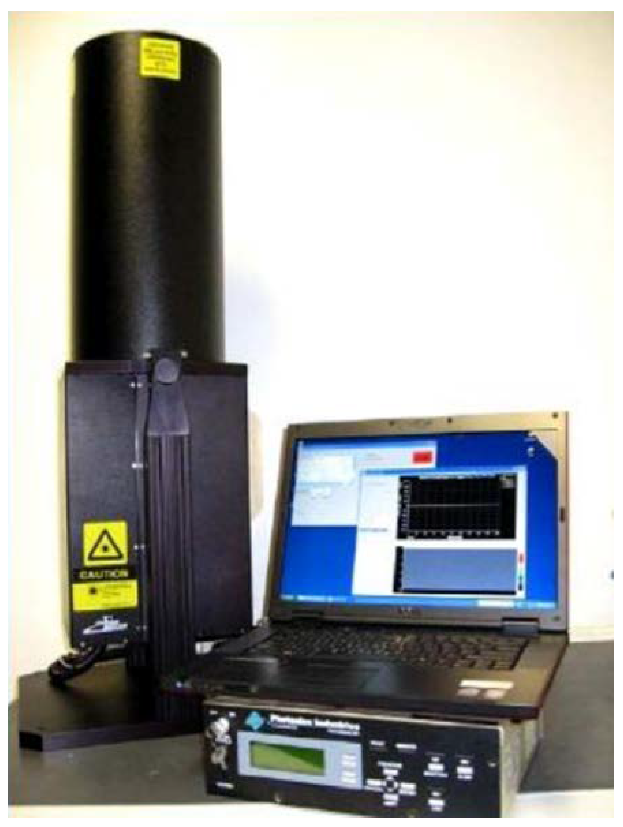
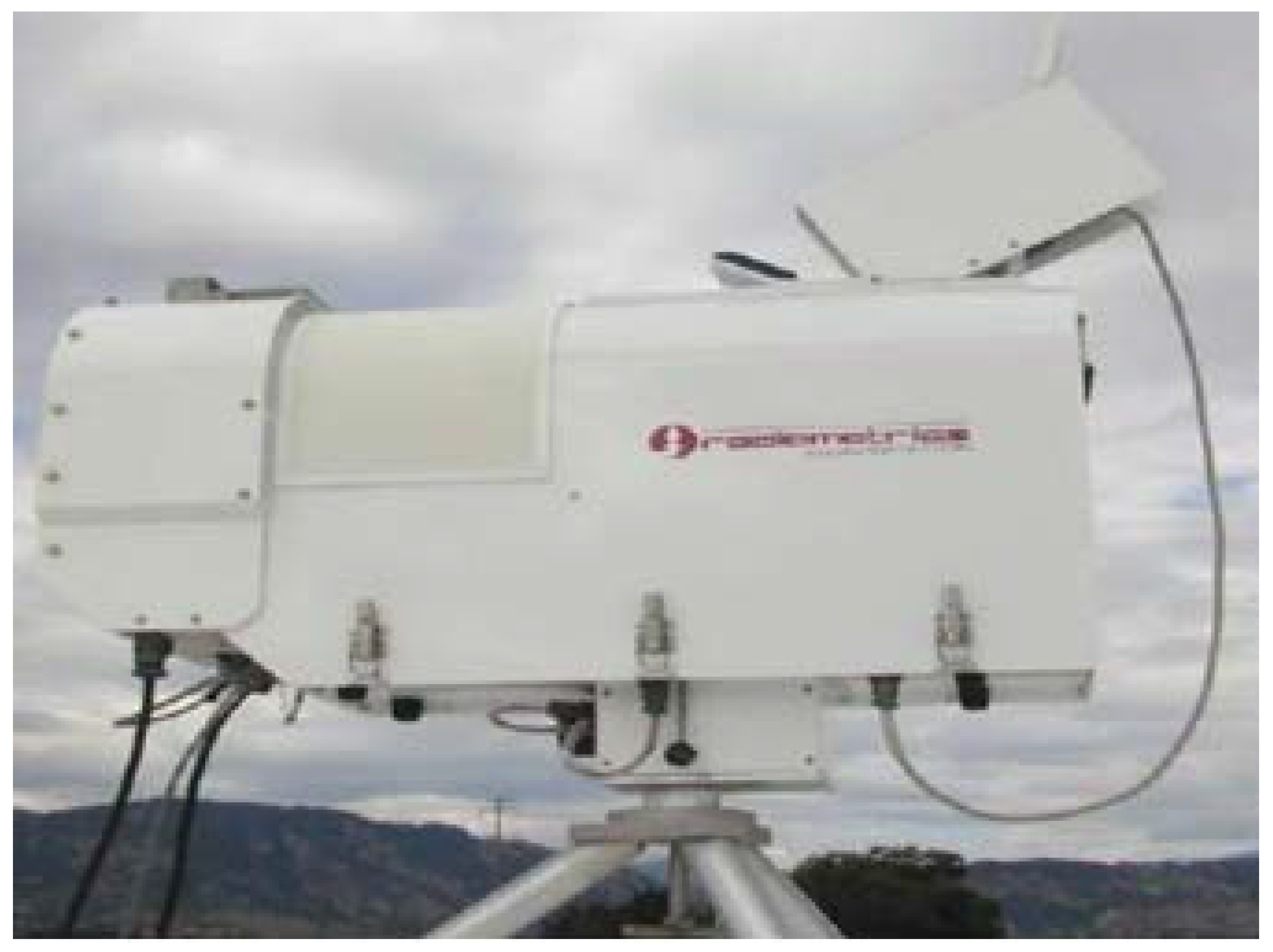
2.1. Instruments
2.2. Retrieval of MMWR
2.3. Combined Retrieval
2.3.1. Calculation of Theoretical Backscattering Coefficient
2.3.2. Calculation of Observed Backscattering Coefficient
2.3.3. Calculation of LWC and Nd
3. Results
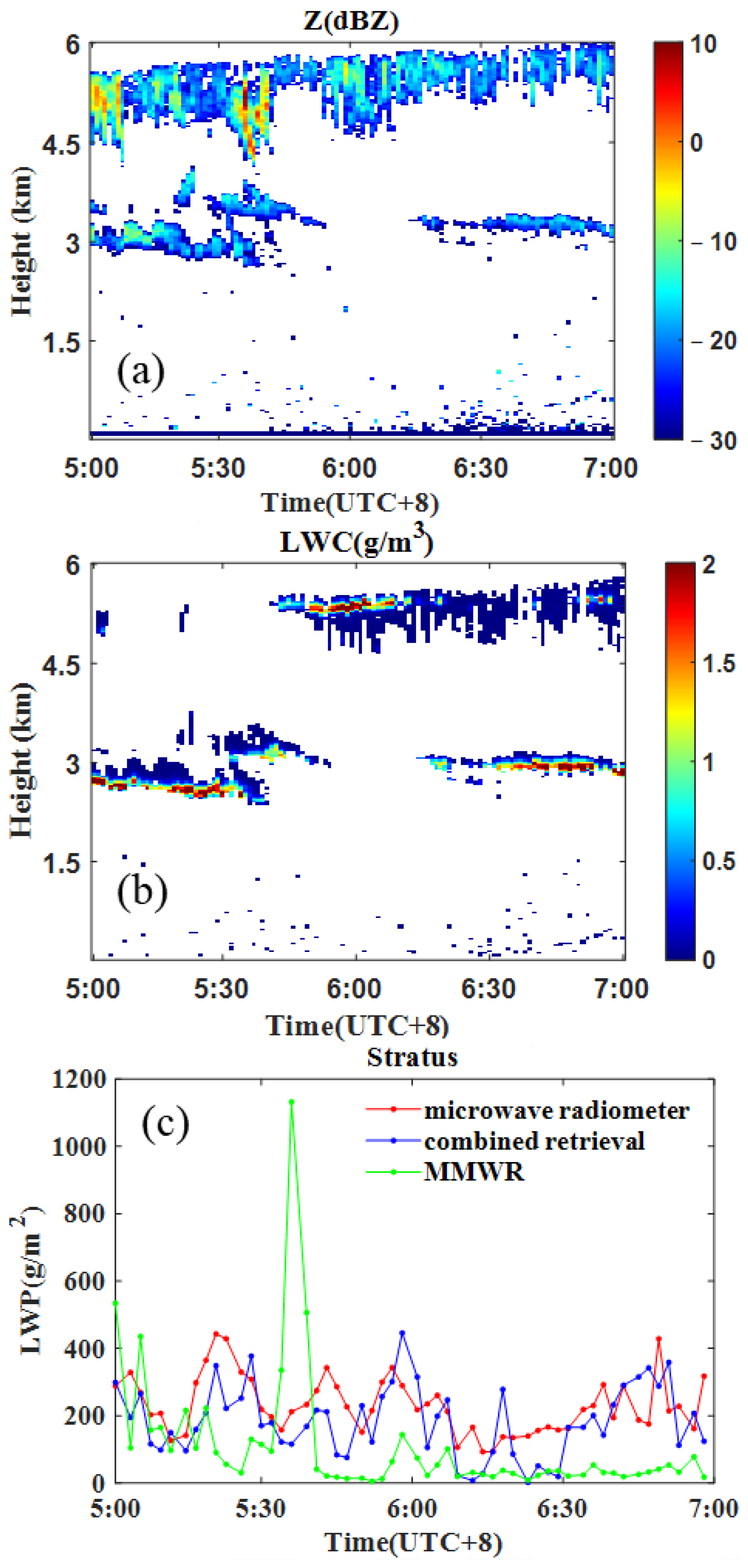
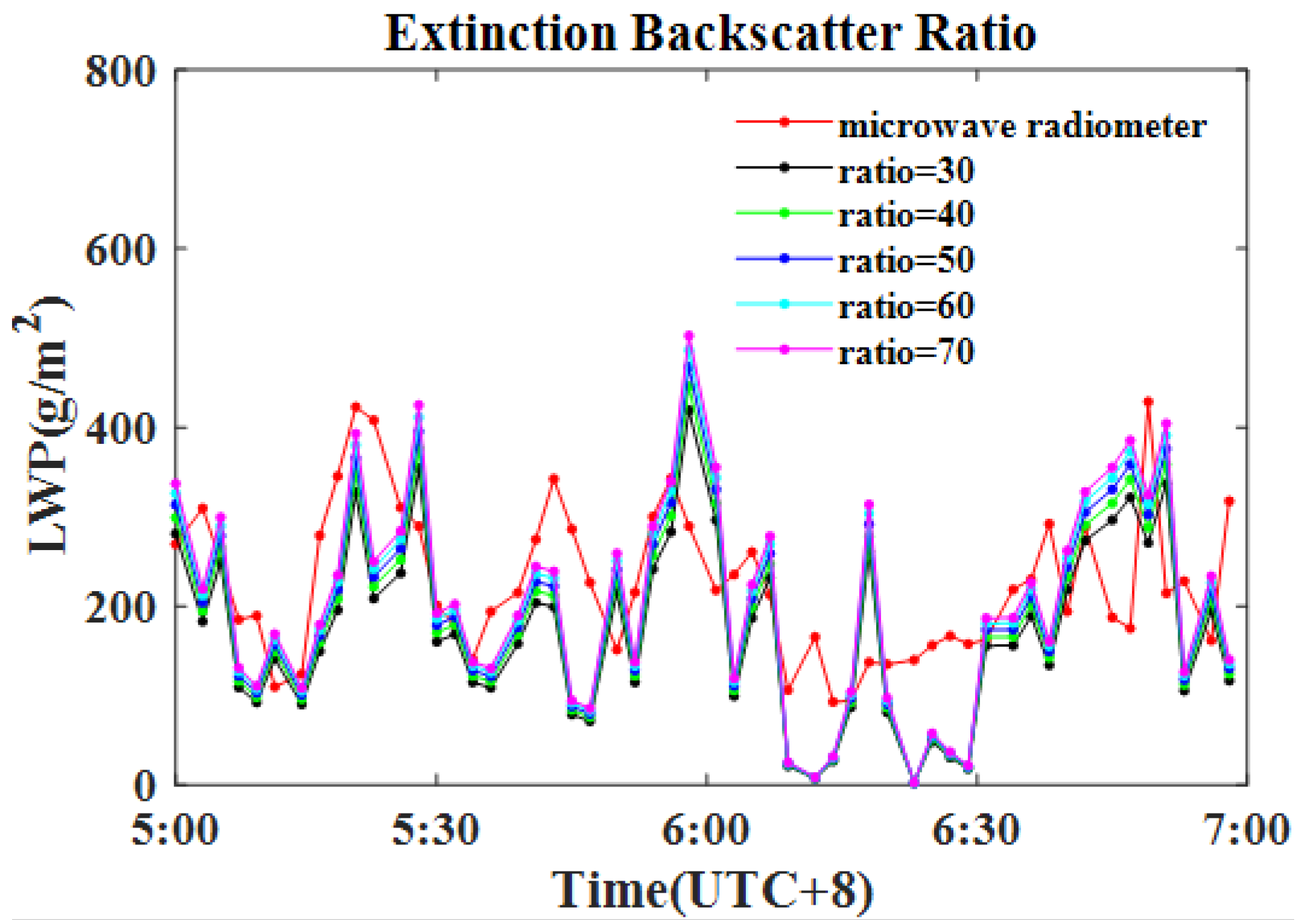
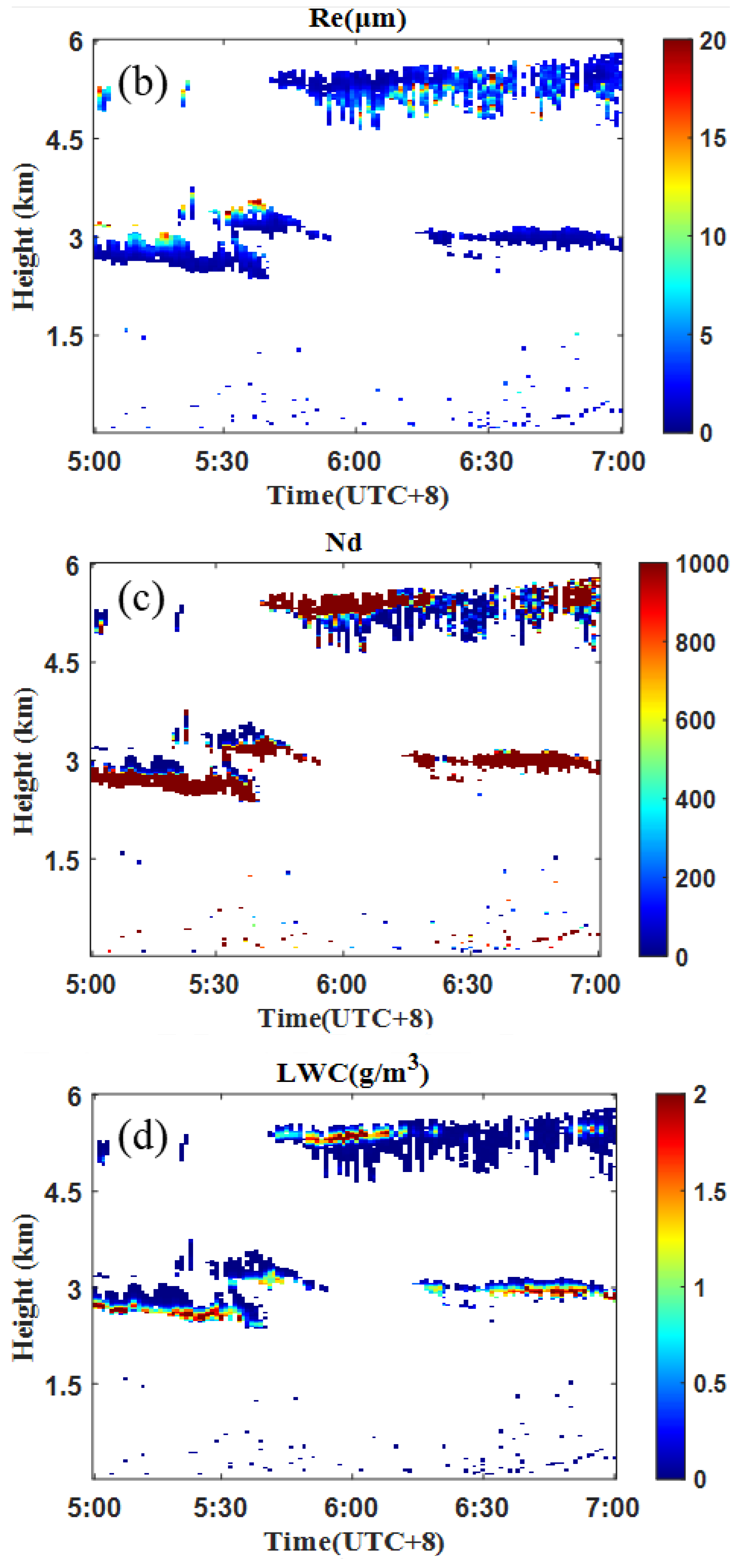
3.1. Stratus
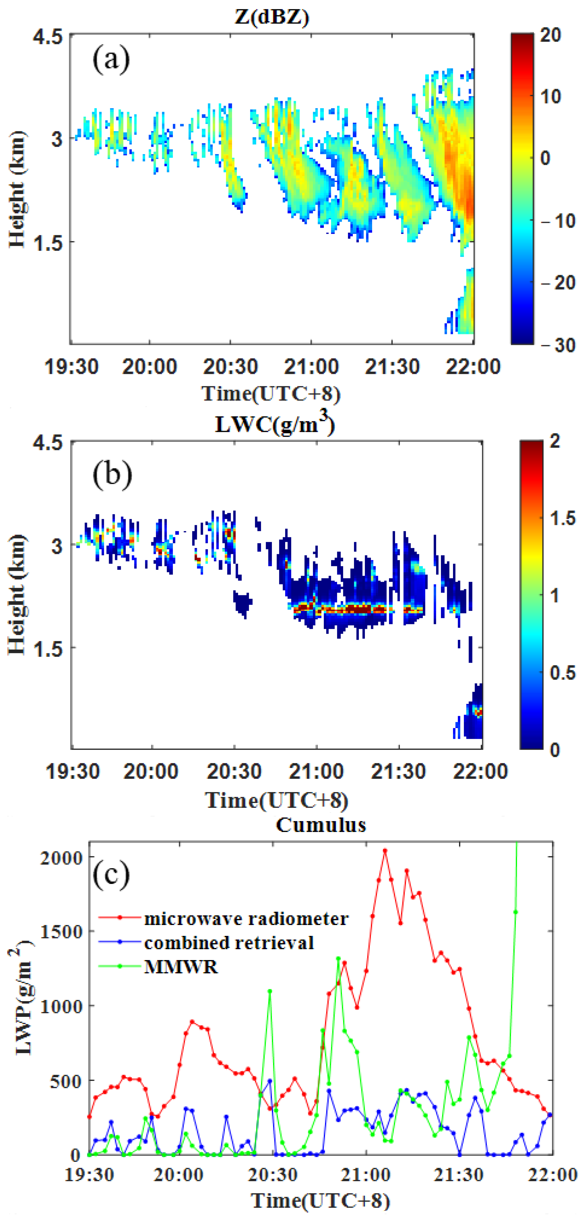
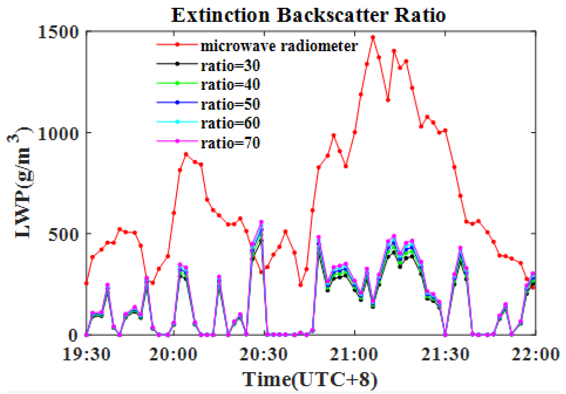
3.2. Cumulus
4. Discussion
5. Conclusions
Author Contributions
Funding
Data Availability Statement
Acknowledgments
Conflicts of Interest
References
- Stocker, T.F.; Qin, D.; Plattner, G.K.; Tignor, M.; Allen, S.K.; Boschung, J.; Nauels, A.; Xia, Y.; Bex, V.; Midgley, P.M. Climate Change 2013: The Physical Science Basis. Contribution of Working Group I to the Fifth Assessment Report of the Intergovemental Panel on Climate Change; Cambridge University Press: Cambridge, UK; New York, NY, USA, 2013; pp. 335–344. [Google Scholar]
- Rosenfeld, D.; Sherwood, S.; Wood, R.; Donner, L. Climate Effects of Aerosol-Cloud Interactions. Science 2014, 343, 379–380. [Google Scholar] [CrossRef]
- Bony, S.; Stevens, B.; Frierson, D.M.W.; Jakob, C.; Kageyama, M.; Pincus, R.; Shepherd, T.G.; Sherwood, S.C.; Siebesma, A.P.; Sobel, A.H.; et al. Clouds, Circulation and Climate Sensitivity. Nat. Geosci. 2015, 8, 261–268. [Google Scholar] [CrossRef]
- Webb, M.J.; Andrews, T.; Bodas-Salcedo, A.; Bony, S.; Bretherton, C.S.; Chadwick, R.; Chepfer, H.; Douville, H.; Good, P.; Kay, J.E.; et al. The Cloud Feedback Model Intercomparison Project (Cfmip) Contribution to Cmip6. Geosci. Model Dev. 2017, 10, 359–384. [Google Scholar] [CrossRef]
- Hartmann, D.L.; Ockertbell, M.E.; Michelsen, M.L. The Effect of Cloud Type on Earths Energy-Balance—Global Analysis. J. Clim. 1992, 5, 1281–1304. [Google Scholar] [CrossRef]
- Ockertbell, M.E.; Hartmann, D.L. The Effect of Cloud Type on Earths Energy-Balance—Results for Selected Regions. J. Clim. 1992, 5, 1157–1171. [Google Scholar] [CrossRef]
- Carslaw, K.S.; Lee, L.A.; Reddington, C.L.; Pringle, K.J.; Rap, A.; Forster, P.M.; Mann, G.W.; Spracklen, D.V.; Woodhouse, M.T.; Regayre, L.A.; et al. Large Contribution of Natural Aerosols to Uncertainty in Indirect Forcing. Nature 2013, 503, 67–71. [Google Scholar] [CrossRef]
- Sun, L.; Wei, J.; Wang, J.; Mi, X.; Guo, Y.; Lv, Y.; Yang, Y.; Gan, P.; Zhou, X.; Jia, C.; et al. A Universal Dynamic Threshold Cloud Detection Algorithm (Udtcda) Supported by a Prior Surface Reflectance Database. J. Geophys. Res. Atmos. 2016, 121, 7172–7196. [Google Scholar] [CrossRef]
- Kotarba, A.Z. Impact of Moderate Resolution Imaging Spectroradiometer (Modis) Cloud Mask Interpretation on Cloud Amount Estimation. J. Geophys. Res. Atmos. 2015, 120, 8971–8986. [Google Scholar] [CrossRef]
- Costantino, L.; Bréon, F.M. Aerosol Indirect Effect on Warm Clouds over South-East Atlantic, from Co-Located Modis and Calipso Observations. Atmos. Chem. Phys. 2013, 13, 69–88. [Google Scholar] [CrossRef]
- Wang, Y.; Zhao, C.F. Can Modis Cloud Fraction Fully Represent the Diurnal and Seasonal Variations at Doe Arm Sgp and Manus Sites? J. Geophys. Res. Atmos. 2017, 122, 329–343. [Google Scholar] [CrossRef]
- Gossard, E.E.; Snider, J.B.; Clothiaux, E.E.; Martner, B.; Gibson, J.S.; Kropfli, R.A.; Frisch, A.S. The Potential of 8-Mm Radars for Remotely Sensing Cloud Drop Size Distributions. J. Atmos. Ocean. Technol. 1997, 14, 76–87. [Google Scholar] [CrossRef]
- Austin, R.T.; Heymsfield, A.J.; Stephens, G.L. Retrieval of Ice Cloud Microphysical Parameters Using the Cloudsat Millimeter-Wave Radar and Temperature. J. Geophys. Res. Atmos. 2009, 114, 19. [Google Scholar] [CrossRef]
- Zhao, C.F.; Qiu, Y.M.; Dong, X.B.; Wang, Z.; Peng, Y.; Li, B.; Wu, Z.; Wang, Y. Negative Aerosol-Cloud re Relationship from Aircraft Observations over Hebei, China. Earth Space Sci. 2018, 5, 19–29. [Google Scholar] [CrossRef]
- Boers, R.; Russchenberg, H.; Erkelens, J.; Venema, V.; van Lammeren, A.; Apituley, A.; Jongen, S. Ground-Based Remote Sensing of Stratocumulus Properties during Clara, 1996. J. Appl. Meteorol. 2000, 39, 169–181. [Google Scholar] [CrossRef]
- Weitkamp, C. (Ed.) Lidar: Range-Resolved Optical Remote Sensing of the Atmosphere; Springer Series on Optical Science; Springer: New York, NY, USA, 2005. [Google Scholar]
- O’Connor, E.J.; Hogan, R.J.; Illingworth, A.J. Retrieving Stratocumulus Drizzle Parameters Using Doppler Radar and Lidar. J. Appl. Meteorol. 2005, 44, 14–27. [Google Scholar] [CrossRef]
- Intrieri, J.M.; Stephens, G.L.; Eberhard, W.L.; Uttal, T. A Method for Determining Cirrus Cloud Particle Sizes Using Lidar and Radar Backscatter Technique. J. Appl. Meteorol. 1993, 32, 1074–1082. [Google Scholar] [CrossRef]
- Mitrescu, C.; Haynes, J.M.; Stephens, G.L.; Miller, S.D.; Heymsfield, G.M.; McGill, M.J. Cirrus Cloud Optical, Microphysical, and Radiative Properties Observed during the Crystal-Face Experiment: A Lidar-Radar Retrieval System. J. Geophys. Res. Atmos. 2005, 110, 17. [Google Scholar] [CrossRef]
- Protat, A.; Delanoë, J.; O’Connor, E.J.; L’Ecuyer, T.S. The Evaluation of CloudSat and CAPLISO Ice Microphysical Products Using Ground-Based Cloud Radar and Lidar Observations. J. Atmos. Ocean. Technol. 2010, 27, 793–810. [Google Scholar] [CrossRef]
- Vivekanandan, J.; Ghate, V.P.; Jensen, J.B.; Ellis, S.M.; Schwartz, M.C. A Technique for Estimating Liquid Droplet Diameter and Liquid Water Content in Stratocumulus Clouds Using Radar and Lidar Measurements. J. Atmos. Ocean. Technol. 2020, 37, 2145–2161. [Google Scholar] [CrossRef]
- Heymsfield, A.J.; Protat, A.; Bouniol, D.; Austin, R.T.; Hogan, R.J.; Delanoë, J.; Okamoto, H.; Sato, K.; van Zadelhoff, G.-J.; Donovan, D.P.; et al. Testing Iwc Retrieval Methods Using Radar and Ancillary Measurements with in Situ Data. J. Appl. Meteorol. Climatol. 2008, 47, 135–163. [Google Scholar] [CrossRef]
- Delanoë, J.; Hogan, R.J. A Variational Scheme for Retrieving Ice Cloud Properties from Combined Radar, Lidar, and Infrared Radiometer. J. Geophys. Res. Atmos. 2008, 113, 21. [Google Scholar] [CrossRef]
- Gossard, E.E. Measurement of Cloud Droplet Size Spectra by Doppler Radar. J. Atmos. Ocean. Technol. 1994, 11, 712–726. [Google Scholar] [CrossRef]
- Tao, F. Research on Particle Spectrum Retrievation and Application Based on Millmeter Wave Cloud Radar. Ph.D. Thesis, Nanjing University of Information Science and Technology, Nanjing, China, 2021. (In Chinese). [Google Scholar]
- He, Q.S.; Li, C.C.; Mao, J.T.; Lau, A.K.H.; Li, P.R. A Study on the Aerosol Extinction-to-Backscatter Ratio with Combination of Micro-Pulse Lidar and Modis over Hong Kong. Atmos. Chem. Phys. 2006, 6, 3243–3256. [Google Scholar] [CrossRef]
- Huang, X.Y.; Zhang, S.; Li, Y.Y.; Huang, J.H.; Wang, P. Study on the two algorithms and result comparison of retrieving cloud microphysical parameters with ground-based radar. J. Meteorol. Sci. 2019, 39, 608–616. (In Chinese) [Google Scholar]
- Shupe, M.D.; Kollias, P.; Poellot, M.; Eloranta, E. On Deriving Vertical Air Motions from Cloud Radar Doppler Spectra. J. Atmos. Ocean. Technol. 2008, 25, 547–557. [Google Scholar] [CrossRef]
- Moise, T.; Flores, J.M.; Rudich, Y. Optical Properties of Secondary Organic Aerosols and Their Changes by Chemical Processes. Chem. Rev. 2015, 115, 4400–4439. [Google Scholar] [CrossRef] [PubMed]
- Welton, E.J.; Voss, K.J.; Gordon, H.R.; Maring, H.; Smirnov, A.; Holben, B.; Schmid, B.; Livingston, J.M.; Russell, P.B.; Durkee, P.A.; et al. Ground-Based Lidar Measurements of Aerosols during Ace-2: Instrument Description, Results, and Comparisons with Other Ground-Based and Airborne Measurements. Tellus Ser. B-Chem. Phys. Meteorol. 2000, 52, 636–651. [Google Scholar] [CrossRef]
- He, Q.S. Remote Sensing of Tropospheric Aerosol Optical Properties and Distribution Characteristics by Micro Pulse Lidar. Ph.D. Thesis, Peking University, Beijing, China, 2006. (In Chinese). [Google Scholar]
- Schmidt, J.; Wandinger, U.; Malinka, A. Dual-Field-of-View Raman Lidar Measurements for the Retrieval of Cloud Microphysical Properties. Appl. Opt. 2013, 52, 2235–2247. [Google Scholar] [CrossRef]
- Schmidt, J.; Ansmann, A.; Bühl, J.; Baars, H.; Wandinger, U.; Mueller, D.; Malinka, A.V. Dual-Fov Raman and Doppler Lidar Studies of Aerosol-Cloud Interactions: Simultaneous Profiling of Aerosols, Warm-Cloud Properties, and Vertical Wind. J. Geophys. Res. Atmos. 2014, 119, 5512–5527. [Google Scholar] [CrossRef]
- Lu, M.L.; Seinfeld, J.H. Effect of Aerosol Number Concentration on Cloud Droplet Dispersion: A Large-Eddy Simulation Study and Implications for Aerosol Indirect Forcing. J. Geophys. Res. Atmos. 2006, 111, 16. [Google Scholar] [CrossRef]
- Crewell, S.; Löhnert, U. Accuracy of Cloud Liquid Water Path from Ground-Based Microwave Radiometry: 2: Sensor Accuracy and Synergy: Art. No. 8042. Radio Sci. 2003, 3, 11. [Google Scholar]
- Westwater, E.R. The Accuracy of Water-Vapor and Cloud Liquid Determination by Dual-Frequency Ground-Based Microwave Radiometry. Radio Sci. 1978, 13, 677–685. [Google Scholar] [CrossRef]
- Wang, N.C.; Zhang, K.; Shen, X.; Wang, Y.; Li, J.; Li, C.; Mao, J.; Malinka, A.; Zhao, C.; Russell, L.M.; et al. Dual-Field-of-View High-Spectral-Resolution Lidar: Simultaneous Profiling of Aerosol and Water Cloud to Study Aerosol-Cloud Interaction. Proc. Natl. Acad. Sci. USA 2022, 119, 9. [Google Scholar] [CrossRef] [PubMed]
- Jimenez, C.; Ansmann, A.; Engelmann, R.; Donovan, D.; Malinka, A.; Schmidt, J.; Seifert, P.; Wandinger, U. The Dual-Field-of-View Polarization Lidar Technique: A New Concept in Monitoring Aerosol Effects in Liquid-Water Clouds—Theoretical Framework. Atmos. Chem. Phys. 2020, 20, 15247–15263. [Google Scholar] [CrossRef]
- Greenwald, T.J.; Stephens, G.L.; Christopher, S.A.; Haar, T.H.V. Observations of the Global Characteristics and Regional Radiative Effects of Marine Cloud Liquid Water. J. Clim. 1995, 8, 2928–2946. [Google Scholar] [CrossRef]
- Zheng, X.J.; Xi, B.K.; Dong, X.Q.; Logan, T.; Wang, Y.; Wu, P. Investigation of Aerosol-Cloud Interactions under Different Absorptive Aerosol Regimes Using Atmospheric Radiation Measurement (Arm) Southern Great Plains (Sgp) Ground-Based Measurements. Atmos. Chem. Phys. 2020, 20, 3483–3501. [Google Scholar] [CrossRef]


| Variable | Backscatter Ratio | Stratus | Cumulus | ||||
|---|---|---|---|---|---|---|---|
| r | MAPD | RMSE | r | MAPD | RMSE | ||
| Backscatter ratio | 30 | 0.51 | 41.56% | 104.51 | 0.52 | 79.44% | 605.77 |
| 40 | 0.51 | 41.26% | 102.96 | 0.52 | 78.51% | 597.33 | |
| 50 | 0.51 | 41.59% | 102.82 | 0.52 | 77.80% | 590.53 | |
| 60 | 0.51 | 41.92% | 103.52 | 0.52 | 77.27% | 584.82 | |
| 70 | 0.51 | 42.20% | 104.75 | 0.52 | 76.88% | 579.87 | |
| Date | Cloud Type | Re(μm) | Nd (cm−3) | LWC (g·m−3) | |||
|---|---|---|---|---|---|---|---|
| Max | Mean | Max | Mean | Max | Mean | ||
| 6 May 2021 | Ac | 36.21 | 7.30 | 9678 | 530 | 0.61 | 0.05 |
| 7 May 2021 | Ac | 7.48 | 3.27 | 23,160 | 4373 | 1.18 | 0.30 |
| 24 May 2021 | As | 62.43 | 6.35 | 125,014 | 4636 | 6.26 | 0.37 |
| 4 June 2021 | As | 55.52 | 8.72 | 14,897 | 745 | 0.90 | 0.08 |
| 20 June 2021 | Ac | 65.27 | 9.47 | 61,114 | 1808 | 4.04 | 0.16 |
| 31 July 2021 | Ns | 91.53 | 9.55 | 215,295 | 4321 | 11.85 | 0.34 |
| 13 August 2021 | Cu | 51.72 | 6.98 | 36,999 | 829 | 2.27 | 0.08 |
| 8 September 2021 | Cu | 60.17 | 7.77 | 79,472 | 1646 | 4.03 | 0.17 |
| 6 October 2021 | Cu→Ns | 66.83 | 9.21 | 50,275 | 1266 | 3.39 | 0.13 |
| 18 October 2021 | Ns | 79.30 | 7.26 | 331,230 | 2545 | 16.62 | 0.28 |
| 2 November 2021 | Ac | 46.04 | 7.26 | 41,250 | 1840 | 2.22 | 0.18 |
| 13 November 2021 | As | 70.14 | 8.49 | 347,521 | 9928 | 17.39 | 0.78 |
| 16 November 2021 | As→Ns | 147.06 | 12.46 | 1,162,432 | 10,434 | 88.34 | 1.17 |
| 17 November 2021 | As | 69.41 | 7.48 | 122,929 | 3509 | 6.83 | 0.39 |
| 18 November 2021 | As | 27.95 | 8.38 | 2265 | 95 | 0.12 | 0.01 |
| 23 November 2021 | As | 37.61 | 6.56 | 22,057 | 441 | 1.39 | 0.03 |
| total | 147.06 | 7.91 | 1,162,432 | 3059 | 88.34 | 0.28 | |
Disclaimer/Publisher’s Note: The statements, opinions and data contained in all publications are solely those of the individual author(s) and contributor(s) and not of MDPI and/or the editor(s). MDPI and/or the editor(s) disclaim responsibility for any injury to people or property resulting from any ideas, methods, instructions or products referred to in the content. |
© 2024 by the authors. Licensee MDPI, Basel, Switzerland. This article is an open access article distributed under the terms and conditions of the Creative Commons Attribution (CC BY) license (https://creativecommons.org/licenses/by/4.0/).
Share and Cite
Lin, W.; He, Q.; Cheng, T.; Chen, H.; Liu, C.; Liu, J.; Hong, Z.; Hu, X.; Guo, Y. A Method for Retrieving Cloud Microphysical Properties Using Combined Measurement of Millimeter-Wave Radar and Lidar. Remote Sens. 2024, 16, 586. https://doi.org/10.3390/rs16030586
Lin W, He Q, Cheng T, Chen H, Liu C, Liu J, Hong Z, Hu X, Guo Y. A Method for Retrieving Cloud Microphysical Properties Using Combined Measurement of Millimeter-Wave Radar and Lidar. Remote Sensing. 2024; 16(3):586. https://doi.org/10.3390/rs16030586
Chicago/Turabian StyleLin, Weiqi, Qianshan He, Tiantao Cheng, Haojun Chen, Chao Liu, Jie Liu, Zhecheng Hong, Xinrong Hu, and Yiyuan Guo. 2024. "A Method for Retrieving Cloud Microphysical Properties Using Combined Measurement of Millimeter-Wave Radar and Lidar" Remote Sensing 16, no. 3: 586. https://doi.org/10.3390/rs16030586