
Insights into Deformation and Mechanism of a Reactivated Landslide Occurrence from Multi-Source Data: A Case Study in Li County, China

Abstract
1. Introduction
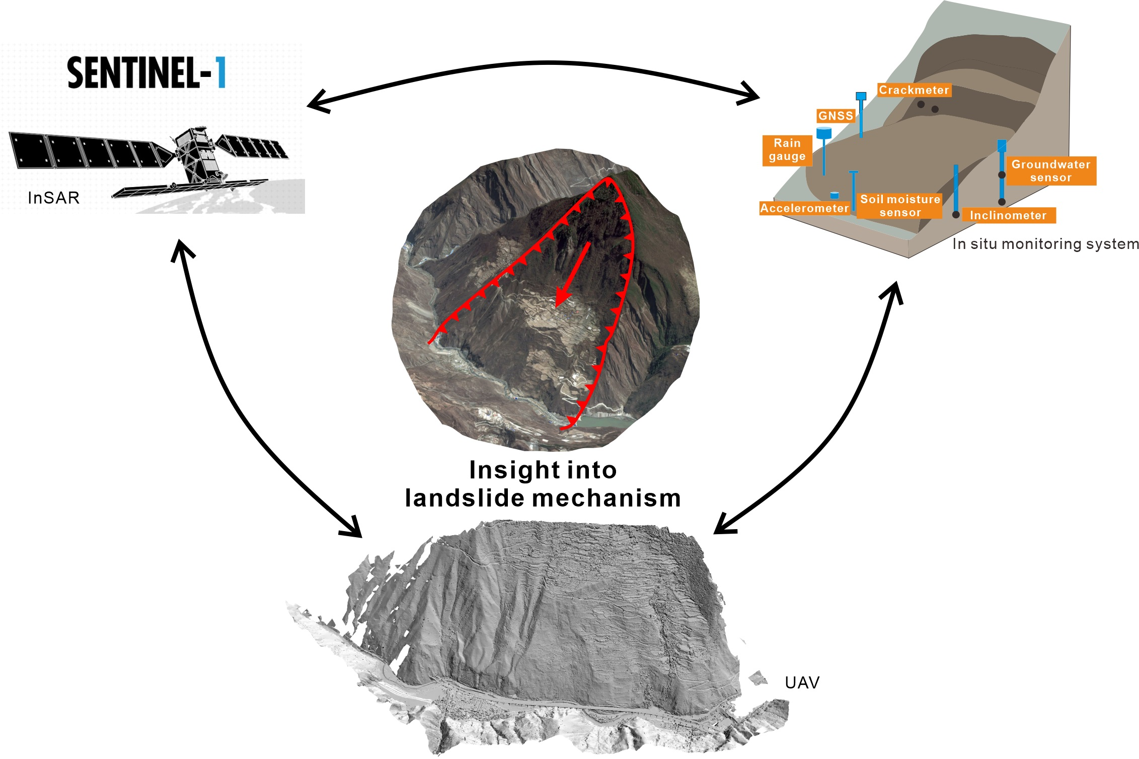
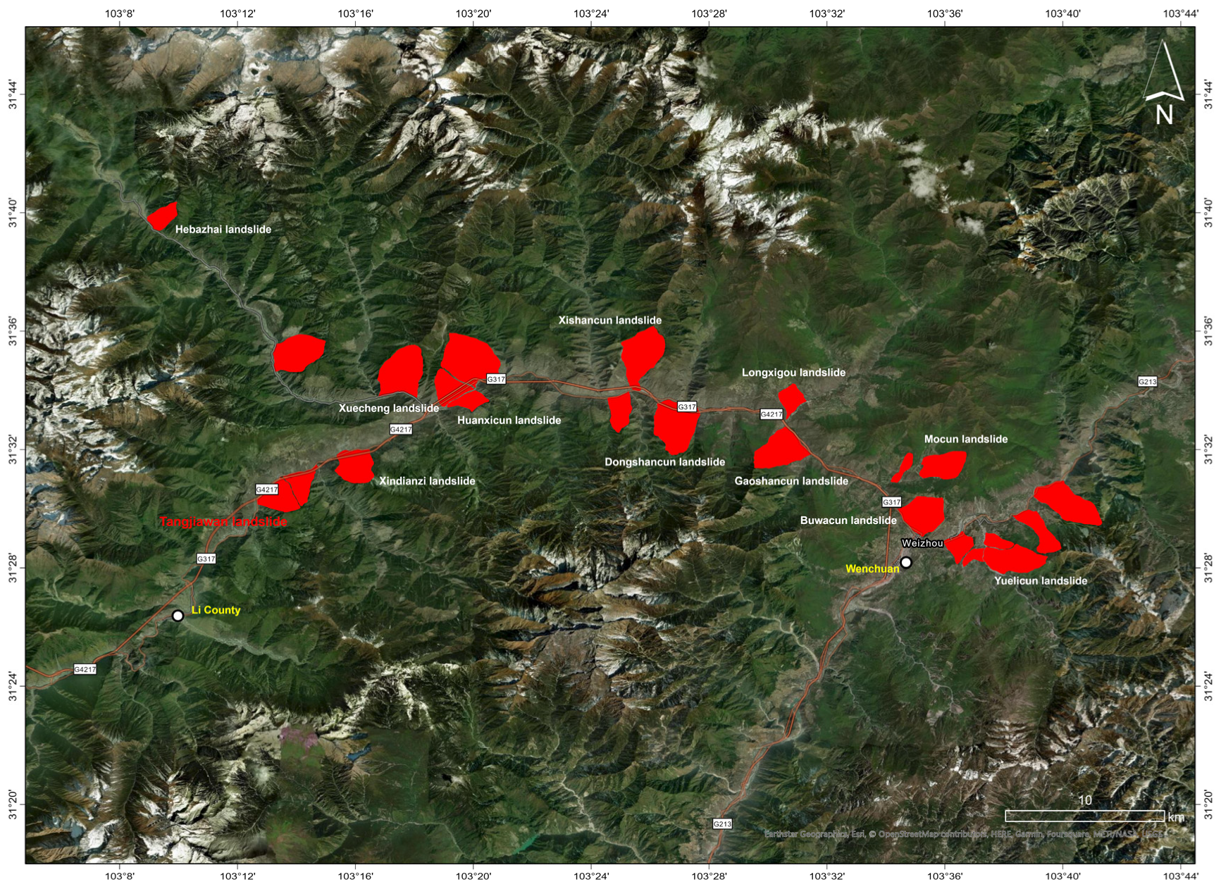
2. Study Area
2.1. Geological Background
2.2. Geomorphology
2.3. Climate and Hydrogeology
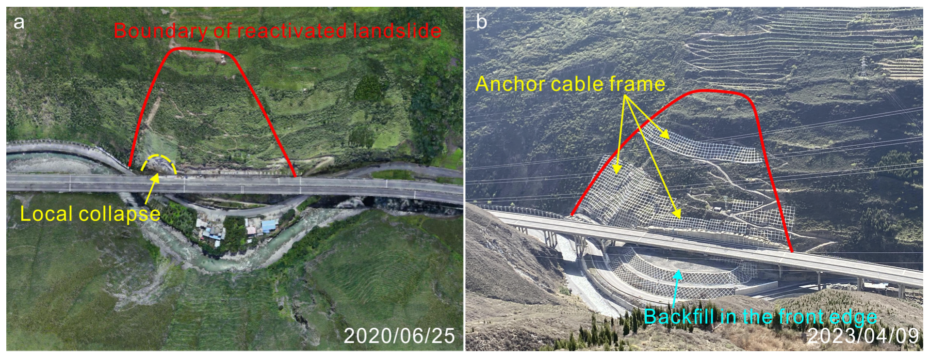
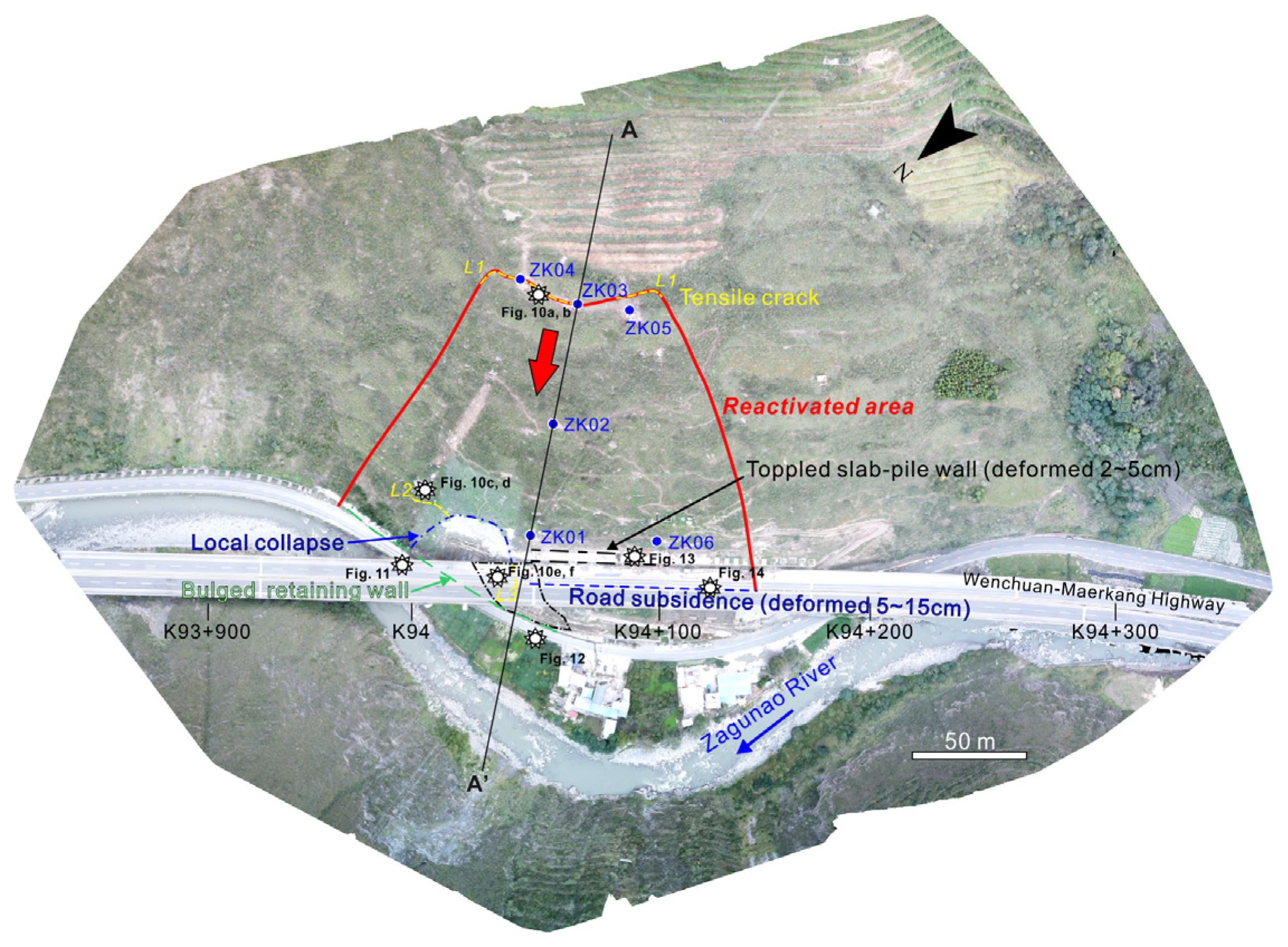
2.4. General Description of the Ancient Landslide and Recent Reactivation
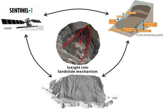
3. Methodology
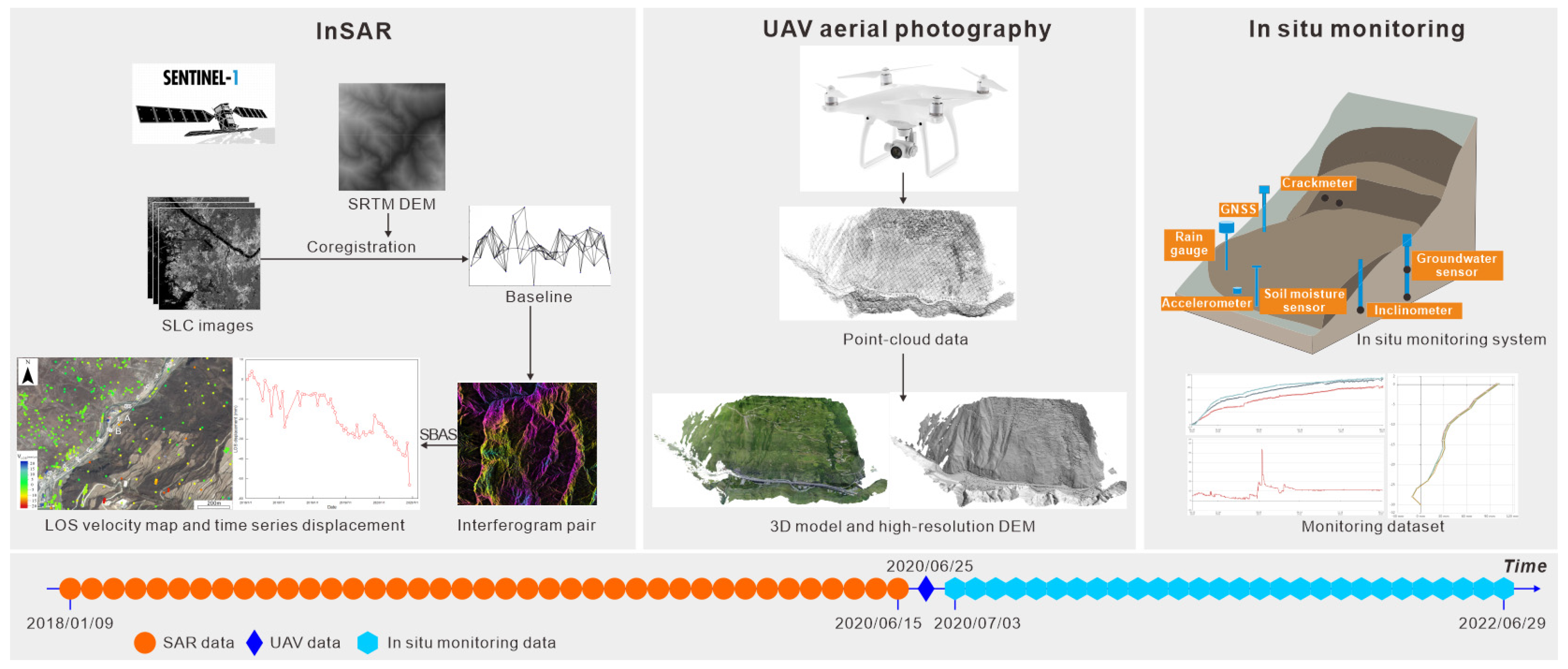
3.1. Ground and UAV Investigations
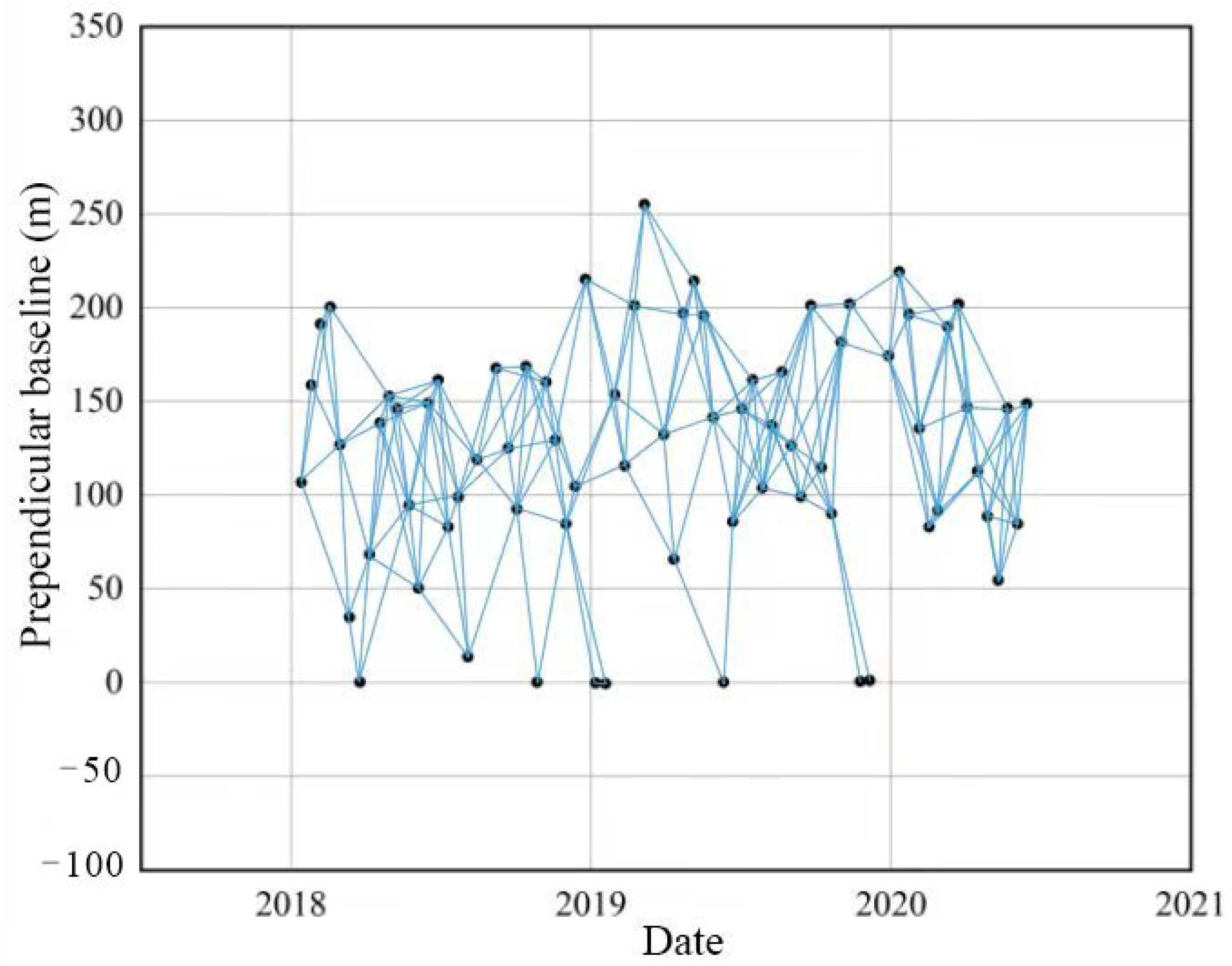
3.2. InSAR Technique
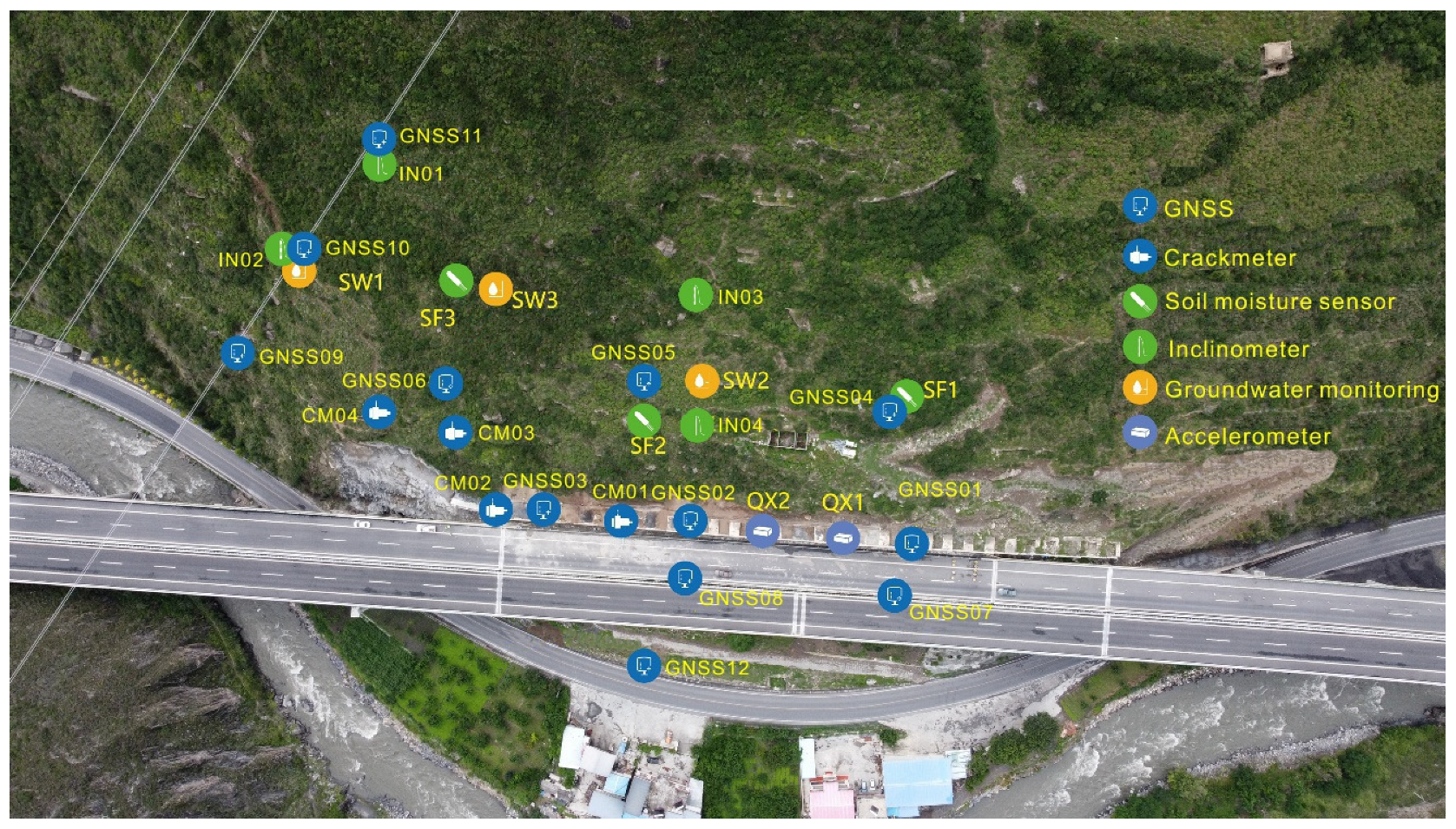
3.3. In Situ Real-Time Monitoring
3.4. Geotechnical Test
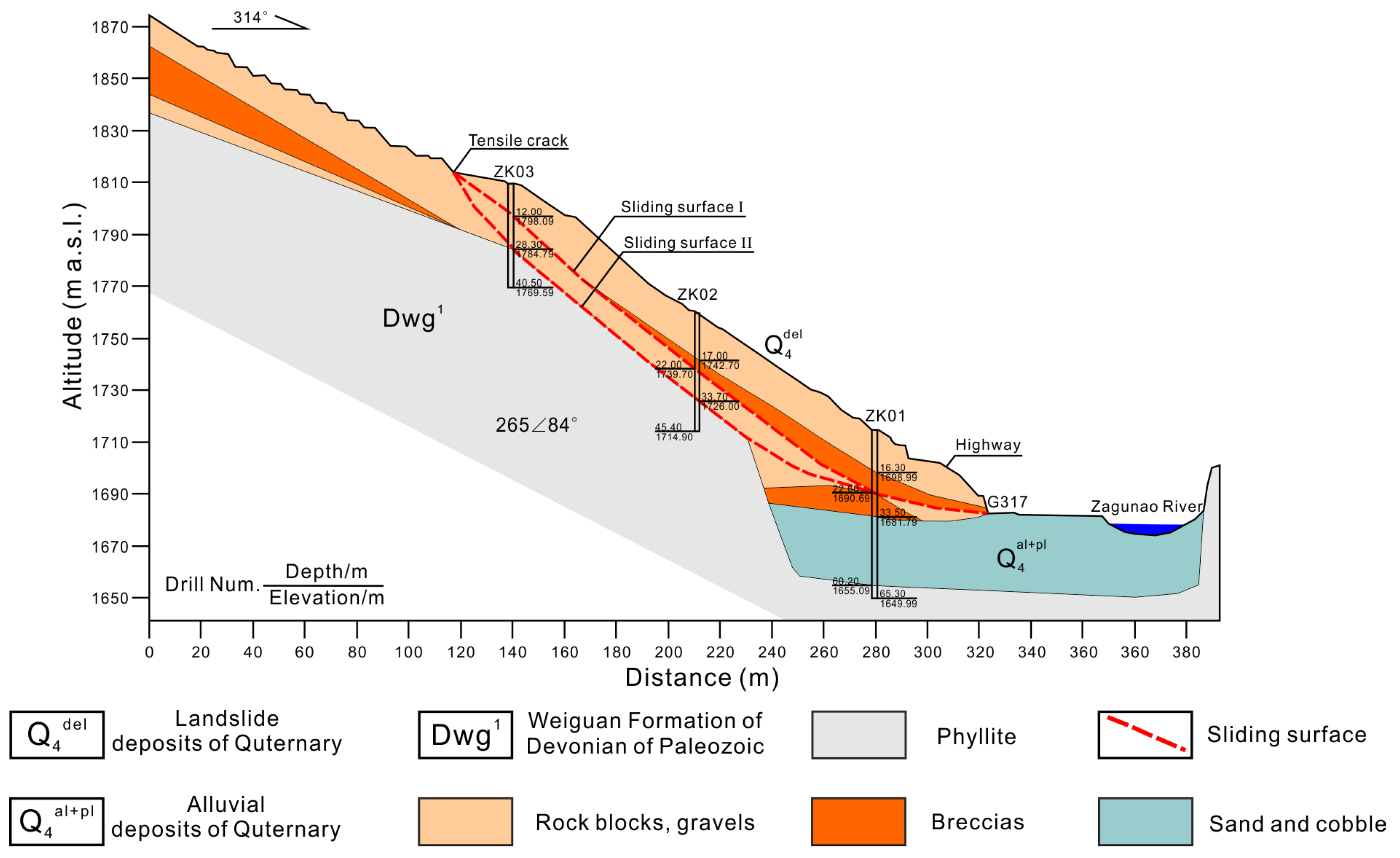
4. Characteristics of the Reactivated Landslide
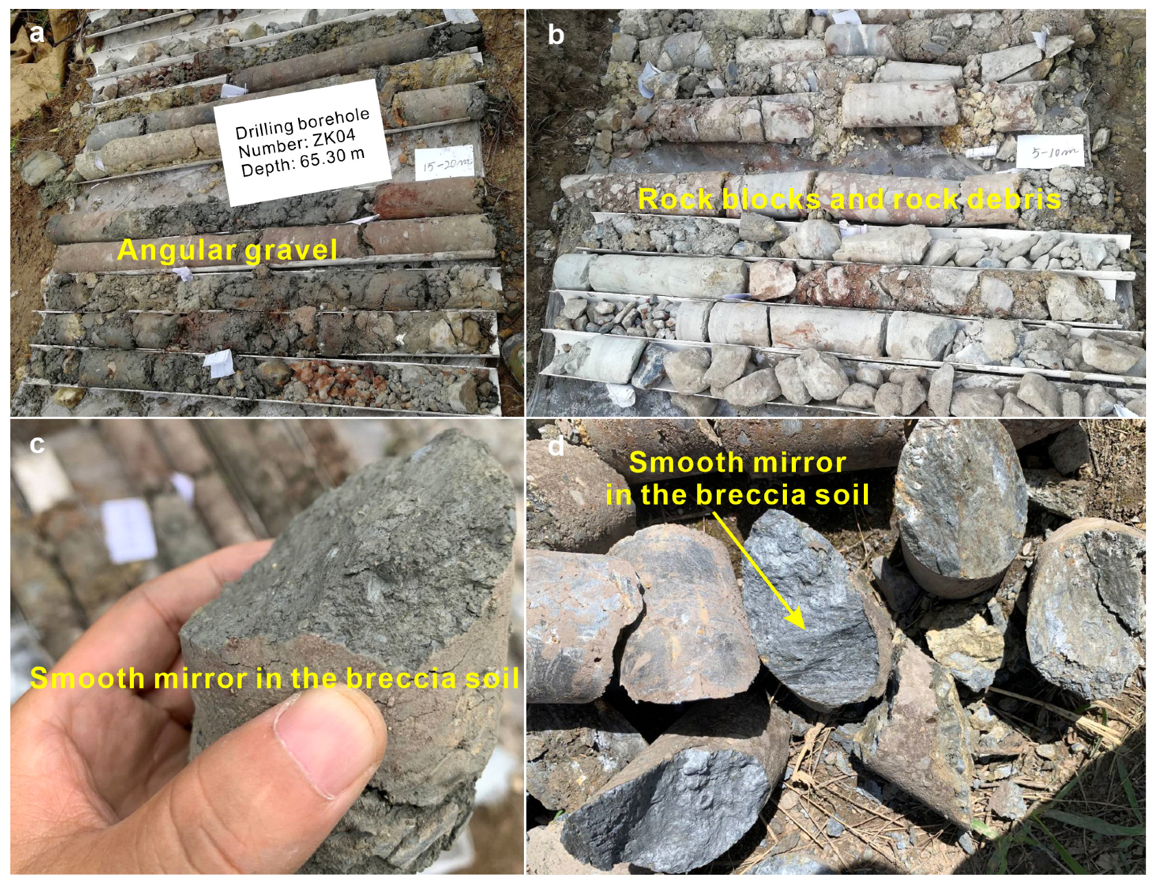
4.1. Structural and Material Characteristics
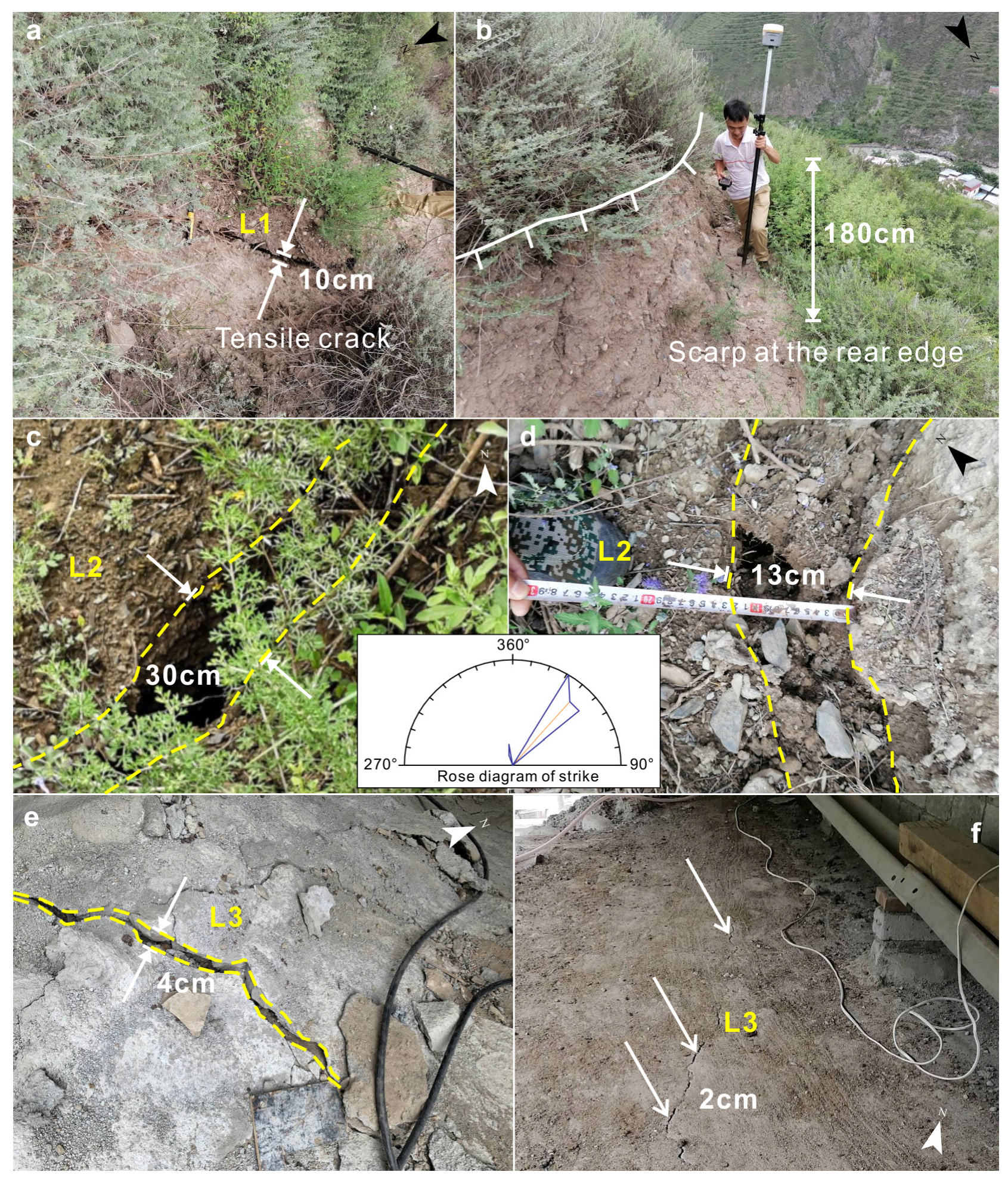
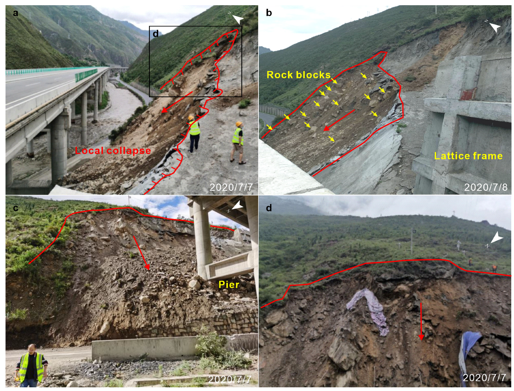
4.2. Ground Deformation
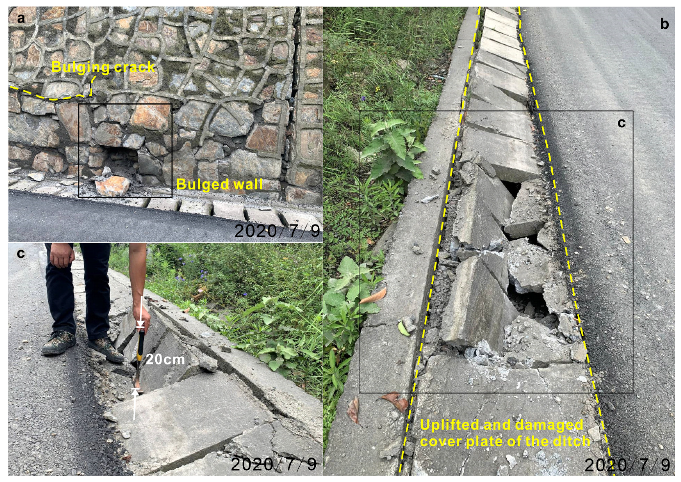
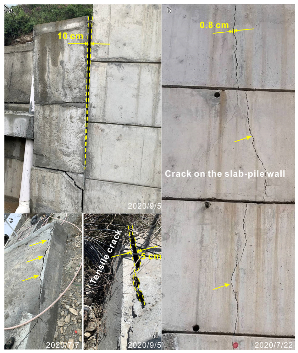
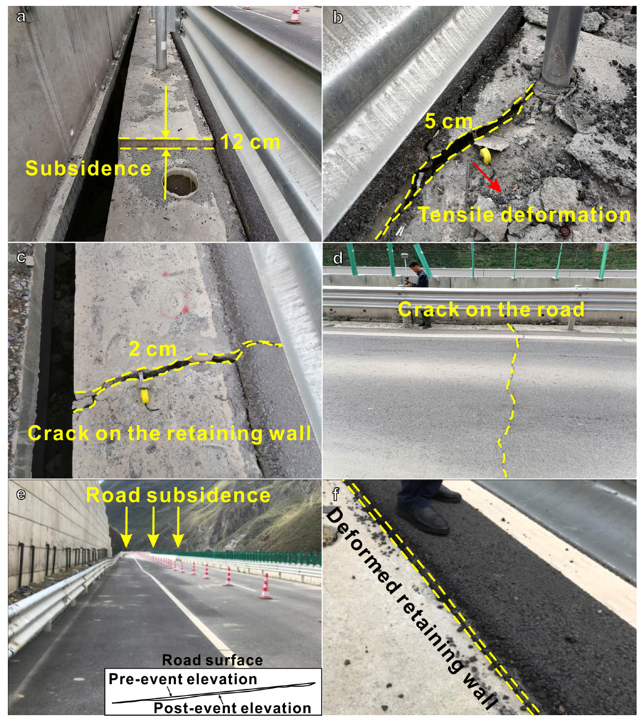
4.3. Infrastructure Deformation
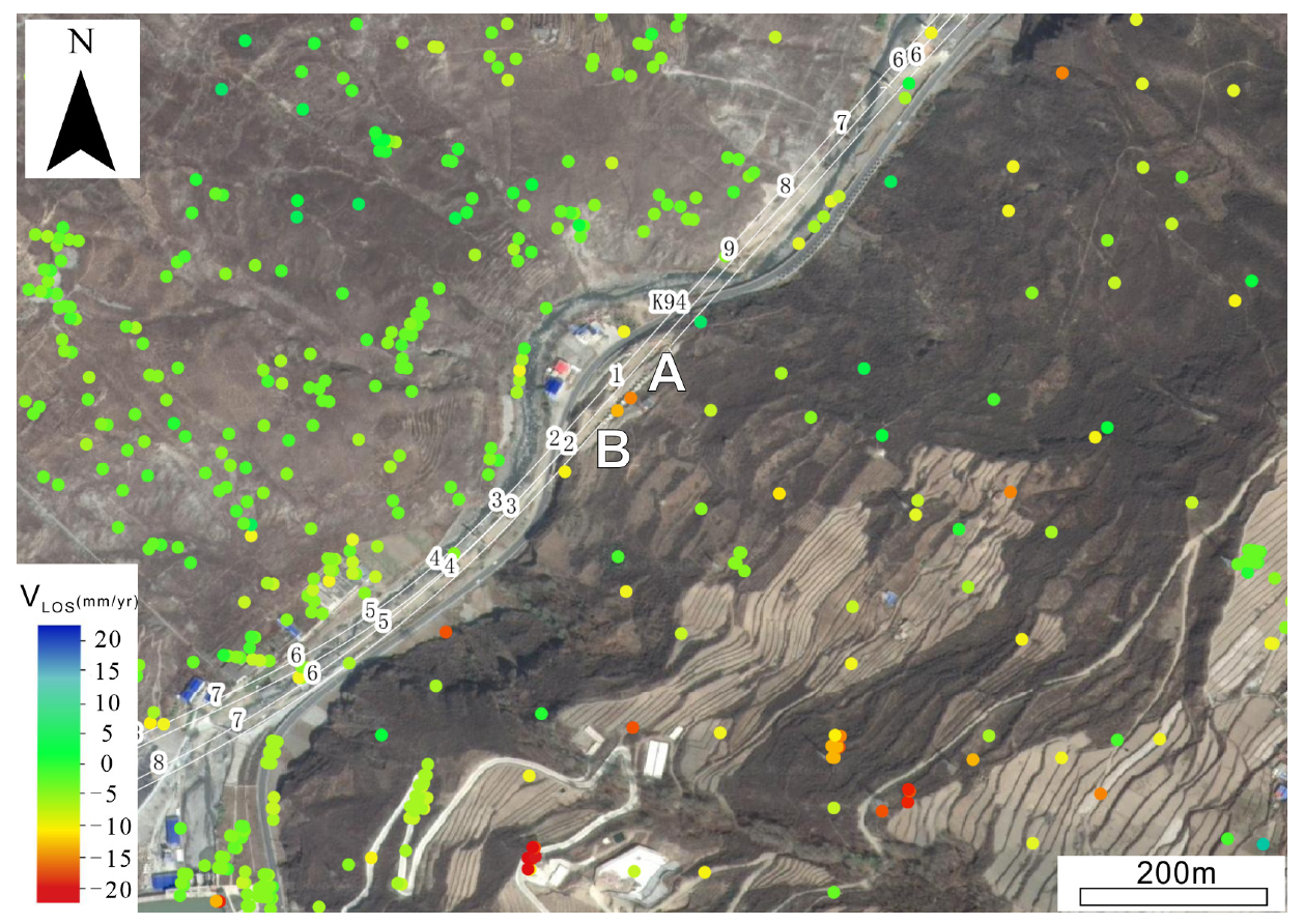
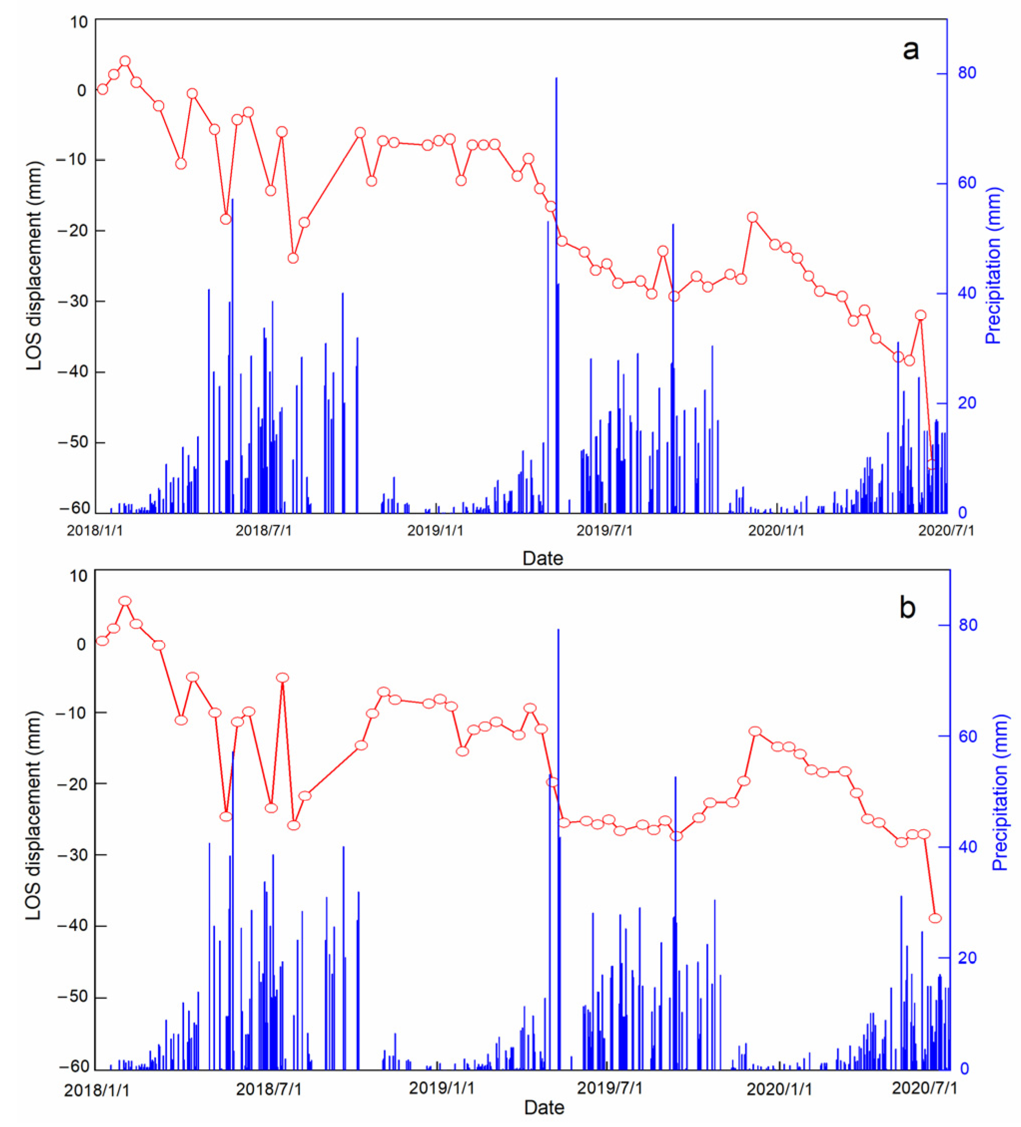
5. InSAR-Derived History Deformation
6. In Situ Real-Time Monitoring Results
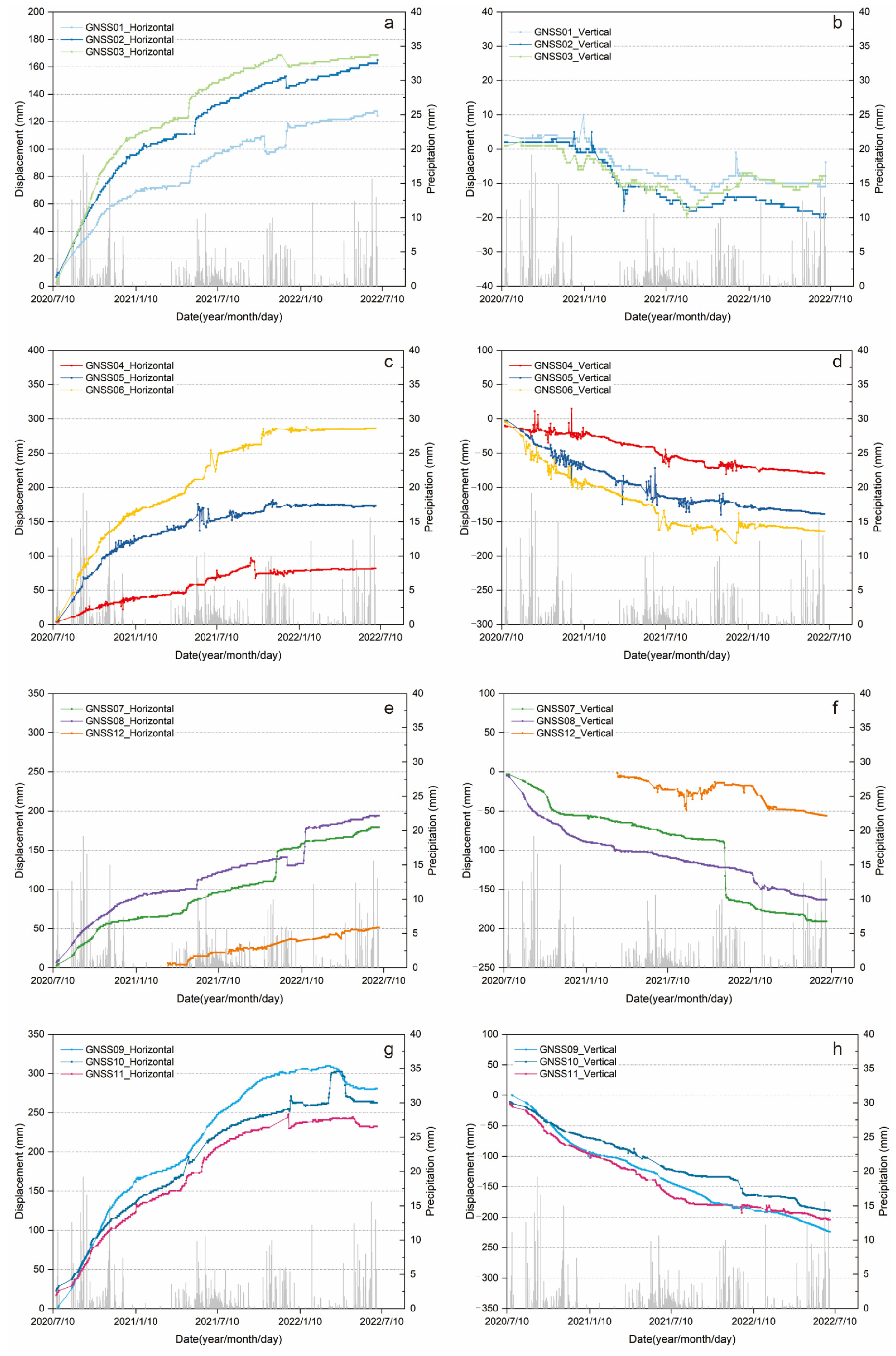
6.1. The Monitoring Results of the Surface Displacement
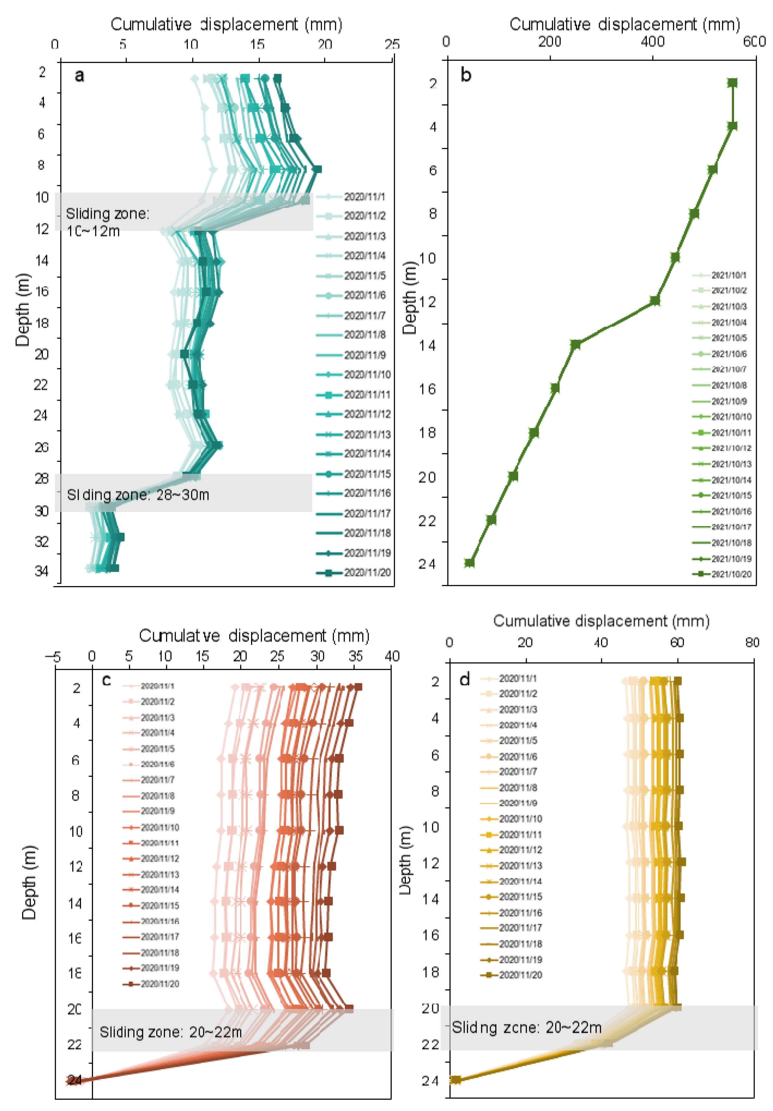
6.2. The Monitoring Results of the Deep Displacement
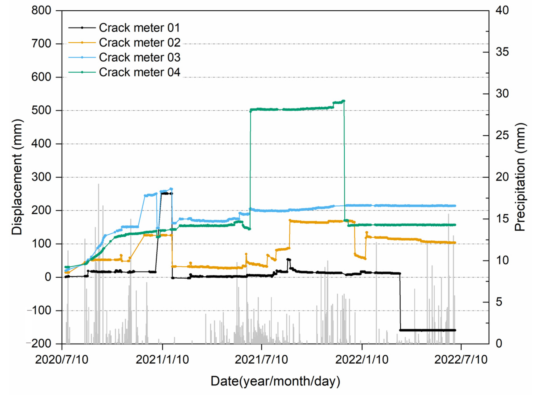
6.3. The Monitoring Results of the Crack Deformation
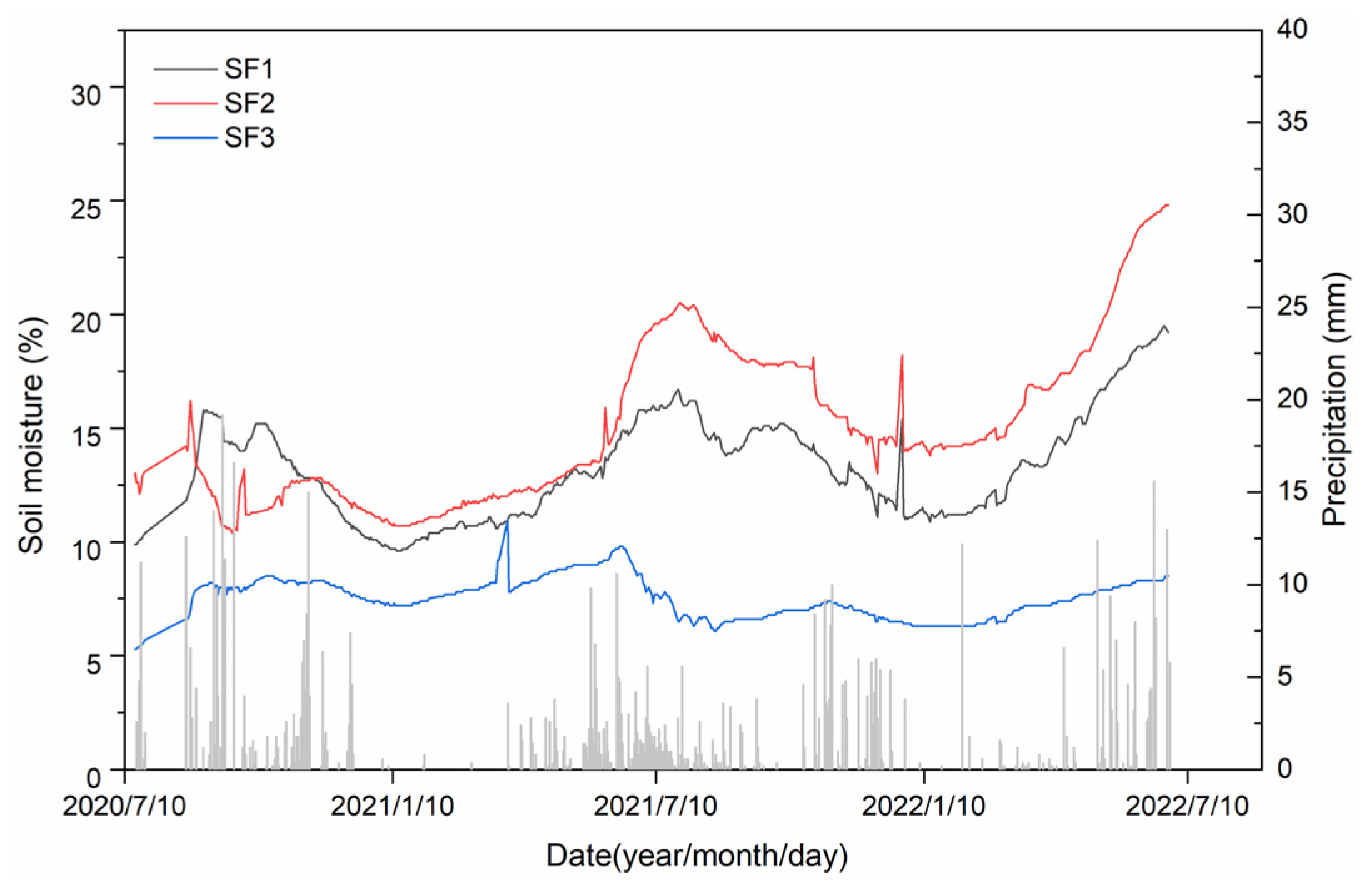
6.4. The Monitoring Results of the Soil Moisture
7. Discussion
7.1. Factors Contributing to the Reactivated Landslide
7.1.1. Predisposing Factors
- Unconsolidated deposits derived from ancient landslide at the base of the slope
- Fragile geo-structure of rock blocks and gravels interlayered with breccias
- Large relief of the original slope
7.1.2. Triggering Factors and Reactivation Mechanism
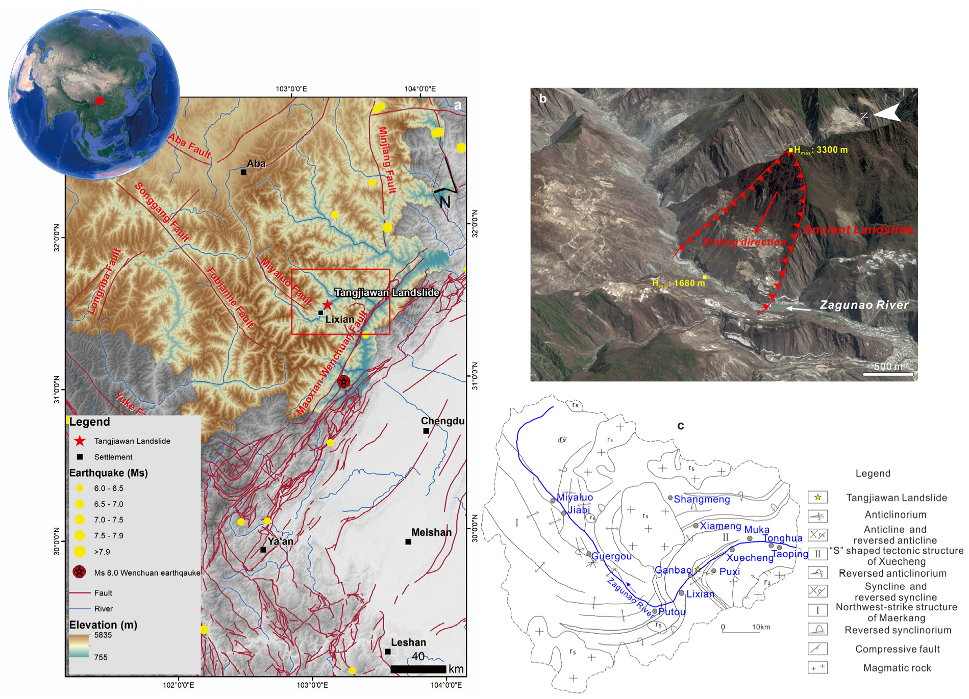
- A total of 13 days of heavy precipitation preceding the reactivation
- The contribution of anthropogenic activity in changing the strength of the slope
7.2. Integrated Monitor Network on Ancient Landslides in Mountainous Area
8. Conclusions
Author Contributions
Funding
Data Availability Statement
Acknowledgments
Conflicts of Interest
References
- Donnini, M.; Napolitano, E.; Salvati, P.; Ardizzone, F.; Bucci, F.; Fiorucci, F.; Santangelo, M.; Cardinali, M.; Guzzetti, F. Impact of event landslides on road networks: A statistical analysis of two Italian case studies. Landslides 2017, 14, 1521–1535. [Google Scholar] [CrossRef]
- Jaiswal, P.; van Westen, C.J.; Jetten, V. Quantitative assessment of landslide hazard along transportation lines using historical records. Landslides 2011, 8, 279–291. [Google Scholar] [CrossRef]
- Penna, D.; Borga, M.; Aronica, G.T.; Brigandì, G.; Tarolli, P. The influence of grid resolution on the prediction of natural and road-related shallow landslides. Hydrol. Earth Syst. Sci. 2014, 18, 2127–2139. [Google Scholar] [CrossRef]
- Yan, Y.; Cui, Y.; Huang, X.; Zhou, J.; Zhang, W.; Yin, S.; Guo, J.; Hu, S. Combining seismic signal dynamic inversion and numerical modeling improves landslide process reconstruction. Earth Surf. Dyn. 2022, 10, 1233–1252. [Google Scholar] [CrossRef]
- Zhang, Y.; Ayyub, B.M.; Gong, W.; Tang, H. Risk assessment of roadway networks exposed to landslides in mountainous regions—A case study in Fengjie County, China. Landslides 2023, 20, 1419–1431. [Google Scholar] [CrossRef]
- Gu, D.M.; Huang, D.; Yang, W.D.; Zhu, J.L.; Fu, G.Y. Understanding the triggering mechanism and possible kinematic evolution of a reactivated landslide in the Three Gorges Reservoir. Landslides 2017, 14, 2073–2087. [Google Scholar] [CrossRef]
- Lu, N.; Wayllace, A.; Oh, S. Infiltration-induced seasonally reactivated instability of a highway embankment near the Eisenhower Tunnel, Colorado, USA. Eng. Geol. 2013, 162, 22–32. [Google Scholar] [CrossRef]
- Massey, C.I.; Petley, D.N.; McSaveney, M.J. Patterns of movement in reactivated landslides. Eng. Geol. 2013, 159, 1–19. [Google Scholar] [CrossRef]
- Jaafari, A.; Najafi, A.; Rezaeian, J.; Sattarian, A.; Ghajar, I. Planning road networks in landslide-prone areas: A case study from the northern forests of Iran. Land Use Policy 2015, 47, 198–208. [Google Scholar] [CrossRef]
- Sun, D.; Gu, Q.; Wen, H.; Xu, J.; Zhang, Y.; Shi, S.; Xue, M.; Zhou, X. Assessment of landslide susceptibility along mountain highways based on different machine learning algorithms and mapping units by hybrid factors screening and sample optimization. Gondwana Res. 2023, 123, 89–106. [Google Scholar] [CrossRef]
- Tanyaş, H.; Görüm, T.; Kirschbaum, D.; Lombardo, L. Could road constructions be more hazardous than an earthquake in terms of mass movement? Nat. Hazards 2022, 112, 639–663. [Google Scholar] [CrossRef]
- He, K.; Ma, G.; Hu, X.; Luo, G.; Mei, X.; Liu, B.; He, X. Characteristics and mechanisms of coupled road and rainfall-induced landslide in Sichuan China. Geomat. Nat. Hazards Risk 2019, 10, 2313–2329. [Google Scholar] [CrossRef]
- Jiang, N.; Li, H.B.; Hu, Y.X.; Zhang, J.Y.; Dai, W.; Li, C.J.; Zhou, J.W. Dynamic evolution mechanism and subsequent reactivated ancient landslide analyses of the “6.17” Danba sequential disasters. Bull. Eng. Geol. Environ. 2022, 81, 149. [Google Scholar] [CrossRef]
- Lee, C.F.; Huang, W.K.; Chang, Y.L.; Chi, S.Y.; Liao, W.C. Regional landslide susceptibility assessment using multi-stage remote sensing data along the coastal range highway in northeastern Taiwan. Geomorphology 2018, 300, 113–127. [Google Scholar] [CrossRef]
- Barla, G.; Debernardi, D.; Perino, A. Lessons learned from deep-seated landslides activated by tunnel excavation. Geomech. Tunn. 2015, 8, 394–401. [Google Scholar] [CrossRef]
- Carlà, T.; Macciotta, R.; Hendry, M.; Martin, D.; Edwards, T.; Evans, T.; Farina, P.; Intrieri, E.; Casagli, N. Displacement of a landslide retaining wall and application of an enhanced failure forecasting approach. Landslides 2018, 15, 489–505. [Google Scholar] [CrossRef]
- Zhang, Y.; Ren, S.; Liu, X.; Guo, C.; Li, J.; Bi, J.; Ran, L. Reactivation mechanism of old landslide triggered by coupling of fault creep and water infiltration: A case study from the east Tibetan Plateau. Bull. Eng. Geol. Environ. 2023, 82, 291. [Google Scholar] [CrossRef]
- Li, W.; Zhao, B.; Xu, Q.; Yang, F.; Fu, H.; Dai, C.; Wu, X. Deformation characteristics and failure mechanism of a reactivated landslide in Leidashi, Sichuan, China, on August 6, 2019: An emergency investigation report. Landslides 2020, 17, 1405–1413. [Google Scholar] [CrossRef]
- Zhang, Z. Mechanism of the 2019 Yahuokou landslide reactivation in Gansu, China and its causes. Landslides 2020, 17, 1429–1440. [Google Scholar] [CrossRef]
- He, K.; Ma, G.; Hu, X.; Liu, B. Failure mechanism and stability analysis of a reactivated landslide occurrence in Yanyuan City, China. Landslides 2021, 18, 1097–1114. [Google Scholar] [CrossRef]
- Nguyen, L.C.; Tien, P.V.; Do, T.N. Deep-seated rainfall-induced landslides on a new expressway: A case study in Vietnam. Landslides 2020, 17, 395–407. [Google Scholar] [CrossRef]
- Carlà, T.; Tofani, V.; Lombardi, L.; Raspini, F.; Bianchini, S.; Bertolo, D.; Thuegaz, P.; Casagli, N. Combination of GNSS, satellite InSAR, and GBInSAR remote sensing monitoring to improve the understanding of a large landslide in high alpine environment. Geomorphology 2019, 335, 62–75. [Google Scholar] [CrossRef]
- Casagli, N.; Intrieri, E.; Tofani, V.; Gigli, G.; Raspini, F. Landslide detection, monitoring and prediction with remote-sensing techniques. Nat. Rev. Earth Environ. 2023, 4, 51–64. [Google Scholar] [CrossRef]
- Wang, W.; Motagh, M.; Mirzaee, S.; Li, T.; Zhou, C.; Tang, H.; Roessner, S. The 21 July 2020 Shaziba landslide in China: Results from multi-source satellite remote sensing. Remote Sens. Environ. 2023, 295, 113669. [Google Scholar] [CrossRef]
- He, K.; Tanyas, H.; Chang, L.; Hu, X.; Luo, G.; Lombardo, L. Modelling InSAR-derived hillslope velocities with multivariate statistics: A first attempt to generate interpretable predictions. Remote Sens. Environ. 2023, 289, 113518. [Google Scholar] [CrossRef]
- He, K.; Lombardo, L.; Chang, L.; Sadhasivam, N.; Hu, X.; Fang, Z.; Dahal, A.; Fadel, I.; Luo, G.; Tanyas, H. Investigating earthquake legacy effect on hillslope deformation using InSAR-derived time series. Earth Surf. Process. Landf. 2024, 49, 980–990. [Google Scholar] [CrossRef]
- Lacroix, P.; Bièvre, G.; Pathier, E.; Kniess, U.; Jongmans, D. Use of Sentinel-2 images for the detection of precursory motions before landslide failures. Remote Sens. Environ. 2018, 215, 507–516. [Google Scholar] [CrossRef]
- Xie, M.; Zhao, W.; Ju, N.; He, C.; Huang, H.; Cui, Q. Landslide evolution assessment based on InSAR and real-time monitoring of a large reactivated landslide, Wenchuan, China. Eng. Geol. 2020, 277, 105781. [Google Scholar] [CrossRef]
- Bian, S.; Chen, G.; Zeng, R.; Meng, X.; Jin, J.; Lin, L.; Zhang, Y.; Shi, W. Post-failure evolution analysis of an irrigation-induced loess landslide using multiple remote sensing approaches integrated with time-lapse ERT imaging: Lessons from Heifangtai, China. Landslides 2022, 19, 1179–1197. [Google Scholar] [CrossRef]
- Shi, X.; Wang, J.; Jiang, M.; Zhang, S.; Wu, Y.; Zhong, Y. Extreme rainfall-related accelerations in landslides in Danba County, Sichuan Province, as detected by InSAR. Int. J. Appl. Earth Obs. 2022, 115, 103109. [Google Scholar] [CrossRef]
- Cook, M.E.; Brook, M.S.; Hamling, I.J.; Cave, M.; Tunnicliffe, J.F.; Holley, R. Investigating slow-moving shallow soil landslides using Sentinel-1 InSAR data in Gisborne, New Zealand. Landslides 2023, 20, 427–446. [Google Scholar] [CrossRef]
- Dong, J.; Zhang, L.; Li, M.; Yu, Y.; Liao, M.; Gong, J.; Luo, H. Measuring precursory movements of the recent Xinmo landslide in Mao County, China with Sentinel-1 and ALOS-2 PALSAR-2 datasets. Landslides 2018, 15, 135–144. [Google Scholar] [CrossRef]
- Cai, J.; Zhang, L.; Dong, J.; Guo, J.; Wang, Y.; Liao, M. Automatic identification of active landslides over wide areas from time-series InSAR measurements using Faster RCNN. Int. J. Appl. Earth Obs. 2023, 124, 103516. [Google Scholar] [CrossRef]
- van Natijne, A.L.; Bogaard, T.A.; van Leijen, F.J.; Hanssen, R.F.; Lindenbergh, R.C. World-wide InSAR sensitivity index for landslide deformation tracking. Int. J. Appl. Earth Obs. 2022, 111, 102829. [Google Scholar] [CrossRef]
- Xia, Z.; Motagh, M.; Li, T.; Peng, M.; Roessner, S. A methodology to characterize 4D post-failure slope instability dynamics using remote sensing measurements: A case study of the Aniangzhai landslide in Sichuan, Southwest China. ISPRS J. Photogramm. Remote Sens. 2023, 196, 402–414. [Google Scholar] [CrossRef]
- Confuorto, P.; Di Martire, D.; Infante, D.; Novellino, A.; Papa, R.; Calcaterra, D.; Ramondini, M. Monitoring of remedial works performance on landslide-affected areas through ground- and satellite-based techniques. Catena 2019, 178, 77–89. [Google Scholar] [CrossRef]
- Di Maio, C.; Fornaro, G.; Gioia, D.; Reale, D.; Schiattarella, M.; Vassallo, R. In situ and satellite long-term monitoring of the Latronico landslide, Italy: Displacement evolution, damage to buildings, and effectiveness of remedial works. Eng. Geol. 2018, 245, 218–235. [Google Scholar] [CrossRef]
- Nappo, N.; Peduto, D.; Mavrouli, O.; van Westen, C.J.; Gullà, G. Slow-moving landslides interacting with the road network: Analysis of damage using ancillary data, in situ surveys and multi-source monitoring data. Eng. Geol. 2019, 260, 105244. [Google Scholar] [CrossRef]
- Stevens, W.R.; Zehrbach, B.E. Inclinometer Data Analysis for Remediated Landslides. In Geotechnical Measurements: Lab and Field, Proceedings of Sessions of Geo-Denver 2000, Denver, CO, USA, 5–8 August 2000; American Society of Civil Engineers: Reston, VA, USA, 2000; Volume 294, pp. 126–137. [Google Scholar]
- Lollino, P.; Giordan, D.; Allasia, P.; Fazio, N.L.; Perrotti, M.; Cafaro, F. Assessment of post-failure evolution of a large earthflow through field monitoring and numerical modelling. Landslides 2020, 17, 2013–2026. [Google Scholar] [CrossRef]
- Tang, H.; Li, C.; Hu, X.; Su, A.; Wang, L.; Wu, Y.; Criss, R.; Xiong, C.; Li, Y. Evolution characteristics of the Huangtupo landslide based on in situ tunneling and monitoring. Landslides 2015, 12, 511–521. [Google Scholar] [CrossRef]
- Tildy, P.; Neducza, B.; Nagy, P.; Kanli, A.I.; Hegymegi, C. Time lapse 3D geoelectric measurements for monitoring of in-situ remediation. J. Appl. Geophys. 2017, 136, 99–113. [Google Scholar] [CrossRef]
- Rosen, P.A.; Gurrola, E.; Sacco, G.F.; Zebker, H. The InSAR scientific computing environment. In Proceedings of the EUSAR 2012; 9th European Conference on Synthetic Aperture Radar, Nuremberg, Germany, 23–26 April 2012. [Google Scholar]
- Yu, C.; Li, Z.; Penna, N.T.; Crippa, P. Generic Atmospheric Correction Model for Interferometric Synthetic Aperture Radar Observations. J. Geophys. Res. Solid Earth 2018, 123, 9202–9222. [Google Scholar] [CrossRef]
- Hooper, A.; Bekaert, D.; Hussain, E.; Spaans, K. StaMPS/MTI Manual: Version 4.1b; School of Earth and Environment, University of Leeds: Leeds, UK, 2018. [Google Scholar]
- He, K.; Ma, G.; Hu, X.; Liu, B.; Han, M. The July 2, 2017, Lantian landslide in Leibo, China: Mechanisms and mitigation measures. Geomech. Eng. 2022, 28, 283–298. [Google Scholar]
- Zhang, C.; Yin, Y.; Dai, Z.; Huang, B.; Zhang, Z.; Jiang, X.; Tan, W.; Wang, L. Reactivation mechanism of a large-scale ancient landslide. Landslides 2021, 18, 397–407. [Google Scholar] [CrossRef]
- Zhao, B.; Yuan, L.; Geng, X.; Su, L.; Qian, J.; Wu, H.; Liu, M.; Li, J. Deformation characteristics of a large landslide reactivated by human activity in Wanyuan city, Sichuan Province, China. Landslides 2022, 19, 1131–1141. [Google Scholar] [CrossRef]
- Luo, G.; Hu, X.; Bowman, E.T.; Liang, J. Stability evaluation and prediction of the Dongla reactivated ancient landslide as well as emergency mitigation for the Dongla Bridge. Landslides 2017, 14, 1403–1418. [Google Scholar] [CrossRef]
- Wen, H.; Zhao, S.; Liang, Y.; Wang, S.; Tao, L.; Xie, J. Landslide development and susceptibility along the Yunling–Yanjing segment of the Lancang River using grid and slope units. Nat. Hazards 2024. [Google Scholar] [CrossRef]


| Natural Density (g/cm3) | Water Content (%) | Liquid Limit (%) | Plastic Limit (%) | Plasticity Index | Peak Strength | Residual Strength | |||||||
|---|---|---|---|---|---|---|---|---|---|---|---|---|---|
| Natural | Saturated | Cohesion (kPa) | Internal Friction Angle (°) | Cohesion (kPa) | Internal Friction Angle (°) | ||||||||
| Natural | Saturated | Natural | Saturated | Natural | Saturated | Natural | Saturated | ||||||
| 1.94 | 7.1 | 21.3 | 35.1 | 16.2 | 18.9 | 16.5 | 6.5 | 22.6 | 15.5 | 5.5 | 2.0 | 15.1 | 11.2 |
Disclaimer/Publisher’s Note: The statements, opinions and data contained in all publications are solely those of the individual author(s) and contributor(s) and not of MDPI and/or the editor(s). MDPI and/or the editor(s) disclaim responsibility for any injury to people or property resulting from any ideas, methods, instructions or products referred to in the content. |
© 2024 by the authors. Licensee MDPI, Basel, Switzerland. This article is an open access article distributed under the terms and conditions of the Creative Commons Attribution (CC BY) license (https://creativecommons.org/licenses/by/4.0/).
Share and Cite
Du, Y.; He, K.; Hu, X.; Ma, H. Insights into Deformation and Mechanism of a Reactivated Landslide Occurrence from Multi-Source Data: A Case Study in Li County, China. Remote Sens. 2024, 16, 1317. https://doi.org/10.3390/rs16081317
Du Y, He K, Hu X, Ma H. Insights into Deformation and Mechanism of a Reactivated Landslide Occurrence from Multi-Source Data: A Case Study in Li County, China. Remote Sensing. 2024; 16(8):1317. https://doi.org/10.3390/rs16081317
Chicago/Turabian StyleDu, Yingjin, Kun He, Xiewen Hu, and Hongsheng Ma. 2024. "Insights into Deformation and Mechanism of a Reactivated Landslide Occurrence from Multi-Source Data: A Case Study in Li County, China" Remote Sensing 16, no. 8: 1317. https://doi.org/10.3390/rs16081317
APA StyleDu, Y., He, K., Hu, X., & Ma, H. (2024). Insights into Deformation and Mechanism of a Reactivated Landslide Occurrence from Multi-Source Data: A Case Study in Li County, China. Remote Sensing, 16(8), 1317. https://doi.org/10.3390/rs16081317