Technical Note

Remote, Rugged Field Scenarios for Archaeology and the Field Sciences: Object Avoidance and 3D Flight Planning with sUAS Photogrammetry

1
Center for Advanced Spatial Technologies, University of Arkansas, Fayetteville, AR 72701, USA
2
Oklahoma Archeological Survey, Norman, OK 73019, USA
3
Department of Anthropology, The University of Oklahoma, Norman, OK 73019, USA
*
Author to whom correspondence should be addressed.
Remote Sens. 2024, 16(8), 1418; https://doi.org/10.3390/rs16081418
Submission received: 28 February 2024 / Revised: 2 April 2024 / Accepted: 9 April 2024 / Published: 17 April 2024

Abstract

:
Advances built into recent sUASs (drones) offer a compelling possibility for field-based data collection in logistically challenging and GPS-denied environments. sUASs-based photogrammetry generates 3D models of features and landscapes, used extensively in archaeology as well as other field sciences. Until recently, navigation has been limited by the expertise of the pilot, as objects, like trees, and vertical or complex environments, such as cliffs, create significant risks to successful documentation. This article assesses sUASs’ capability for autonomous obstacle avoidance and 3D flight planning using data collection scenarios carried out in Black Mesa, Oklahoma. Imagery processed using commercial software confirmed that the collected data can build photogrammetric models suitable for general archaeological documentation. The results demonstrate that new capabilities in drones may open up new field environments previously considered inaccessible, too risky, or costly for fieldwork, especially for all but the most expert pilots. Emerging technologies for drone-based photogrammetry, such as the Skydio 2+ considered here, place remote, rugged terrain within reach of many archaeological research units in terms of commercial options and cost.

Graphical Abstract

1. Introduction

Remote and rugged environments have always been a challenge for data collection with small, unmanned aircraft systems (sUASs), colloquially known as “drones”, for archaeology and related field-based sciences such as biology, ecology, and geosciences, among others [1,2,3,4,5]. And yet, there is great utility, along with a rising demand, for feature-scale as well as meso-scale and macro-scale data acquisition of cultural and natural landscapes across these domains [6,7,8,9,10,11,12,13,14]. Developing new methods to conduct sUAS surveys seamlessly, cheaply, and without unnecessary risk to personnel or equipment is a top priority for researchers working across the globe [15,16].
This article reports the results of photogrammetric field data collection using a Skydio 2+ sUAS, which has the capability to both avoid objects in the field and perform flight patterns that, in addition to traditional horizontal flight paths, can map vertical features or 3D objects (referred to hereafter as “volumetric” mapping) without prior planning (i.e., before going out in the field). These capabilities open new possibilities for field documentation that have otherwise required advanced- or expert-level piloting and/or high-cost equipment. Obstacle avoidance and volumetric mapping, considered more broadly, bring to the fore issues with conducting fieldwork in remote environments and new ideas about how researchers might approach them. Applications for these two sUASs features were evaluated for their usefulness in archaeology and the related field sciences through a set of flights that explored multiple fieldwork scenarios. The scenarios incorporated challenges that researchers face in rugged, vertical, and hard-to-access terrain, but documenting 3D features from multiple perspectives and incorporating the larger local context were critical.
This case study took place in October 2022 at a set of remote rock art sites situated around Black Mesa, located on the far western edge of the panhandle of Oklahoma. The goals of the test flights were to: (1) explore hazardously located, hard-to-document features where, without autonomous flight planning and/or object avoidance, conducting sUAS photogrammetry would be challenging, if not impossible; (2) attempt sUAS photogrammetry where handheld photographs would be too time-intensive to be deployed and/or the overall context would be lost; and (3) create and execute mission plans in the field without additional data or prior knowledge of the areas. We designed flights to document known petroglyphs (carved rock art) that are located on freestanding boulders, along cliff faces, and within shallow caves, as part of exploring a variety of scenarios and environments and building models of actual features of interest. We also captured an archaeological site that was located on a distant, hard-to-access cliff promontory to explore the capabilities for a more remote launch site, with both flight planning and data acquisition conducted from a distance. Each location resulted in 3D models that were processed with Agisoft Metashape 1.8.0, a standard, commercial photogrammetric software. The results of our study suggest that there is great potential for fieldwork in remote and/or obstacle-filled settings and that, even now, there exist reasonably priced, out-of-the-box solutions that can move applications forward and open up drone-based surveys to a wider range of users, let alone environmental settings.

The Need for and Challenges of Data Acquisition in Remote, Rugged Field Settings

Drone-based photogrammetry is an increasingly popular and indispensable method used across the field sciences. Archaeologists, like others working in remote, rugged settings, choose sUAS photogrammetry because it allows them to document and monitor features of interest that are too geographically large, dispersed, or challenging to capture through other methods [1,2,7,16,17]. However, fieldwork often takes place in vegetated, rural, and tricky or hazardous terrain, including GPS-denied areas. These challenging environments serve as a major limitation to where drone-based photogrammetry can occur, which was not previously achievable or practical for any but the most expert pilots. Rock art, for example, is often intentionally placed by the practitioner in hard-to-access areas, where carrying photography equipment can be difficult if not impossible; therefore, sUASs offer an appealing approach [18,19]. Even if handheld photogrammetry of a specific feature is possible, omitting the surrounding rock face, cave, or greater landscape from a model can result in losing important contextual data. Adaptations used in cliff and cave environments, for example, in [20,21], are often ad hoc and case-specific, rather than a more holistic attempt to address these problems.
In general, sUASs applications are limited by access issues and limitations placed on pilots, such as the use of programmed paths or manual piloting. This also extends to GPS-denied environments, such as along cliffs or within caves. Trees, nesting areas, powerlines, buildings, and air traffic can also interrupt flight paths. Even when flight planning can incorporate terrain following—for example, using a previously acquired digital elevation model (DEM) to follow the top of a tree line—there is simply terrain that is too unpredictable or challenging to risk such a flight. The larger or more complex a study area is for manual flying, the harder it can be to maintain adequate overlap and sidelap for photogrammetry. Complex study areas are accompanied by higher risks, with little or no room for error in those flights, and may require additional flying—and with every additional flight, there is more risk of crashing.
However, the need for documentation (prospection), monitoring (preservation), and mapping in remote environments at the level of a single object or site of interest, let alone meso- or macro-scale data acquisition, is tremendous. These data are used to address a specific question, visualize a landscape, or serve as a component of a larger dataset, including spatial and non-spatial data, among other end products [2,6,22]. In archaeology, for example, sUAS photogrammetry has been used around the world to reveal hidden landscapes [12], hilltop fortresses [23], and improve our understanding of human evolution through the accurate location of fossil deposits [24], among many other applications. They have been used to reconstruct ancient and historical environments, for example, in [13], knowledge of which can and has been used to empower Indigenous communities [25].
Researchers chose sUASs-based photogrammetry with the intent to accurately capture complex 3D spaces and model ground surfaces at a relatively low cost [26,27]. Topographic relief can be lost with a top-down flight path, such as an area of interest located on the side of a building or underside of a cliff’s overhang. Again, handheld photogrammetry can supplement overhead images, but only to a certain extent: the further away or more complexly shaped an object is, the harder it may be to capture with a ground-based camera system. Features may be hard-to-access, located high on the sides of cliffs, in between crevices, and beyond where it is realistic or safe to transport personnel or equipment. The time required for additional documentation, especially if these areas are extensive, lowers the feasibility of handheld photogrammetry in these types of environments.

2. Materials and Methods

This case study used the Skydio 2+ with a Sony IMX577 1/2.3” 12.3MP CMOS camera and 3.7 mm lens. The Skydio 2+ is a mid-range commercial option with in-built obstacle avoidance and a volumetric flight planning software upgrade known as 3D Scan [28]. Additional details about the Skydio 2+ are included in the Supplementary Materials and found in Williamson’s review [28]. Recent restrictions in the United States and at the federal and, for some, state levels prohibit the use of more common DJI drones in scientific research. The Skydio 2+, therefore, was used here to evaluate how to approach rugged, remote environments for archaeological research and whether the technology is sufficient for general documentation needs for a typical research unit.
Flight planning was conducted using 3D Scan. All flights used 80% overlap, 70% sidelap, and the 3D Capture Scan Mode for their settings (Supplementary Materials, Reports). Flights took place on 26–27 October 2022, between the morning and early evening, during light-to-moderate (<20 mph) wind conditions in which flying is feasible. Between five and seven pillars were set for each flight, with flight times ranging from 10 to 16 min in length. The imagery was processed using Agisoft Metashape Professional 1.8.0. Parameters for the depth map generation included selecting a high-quality model with a mild filtering mode and 16 sets for the maximum number of neighbors. The sparse point cloud was cleaned up and reprocessed to remove extraneous points before building the dense point cloud.

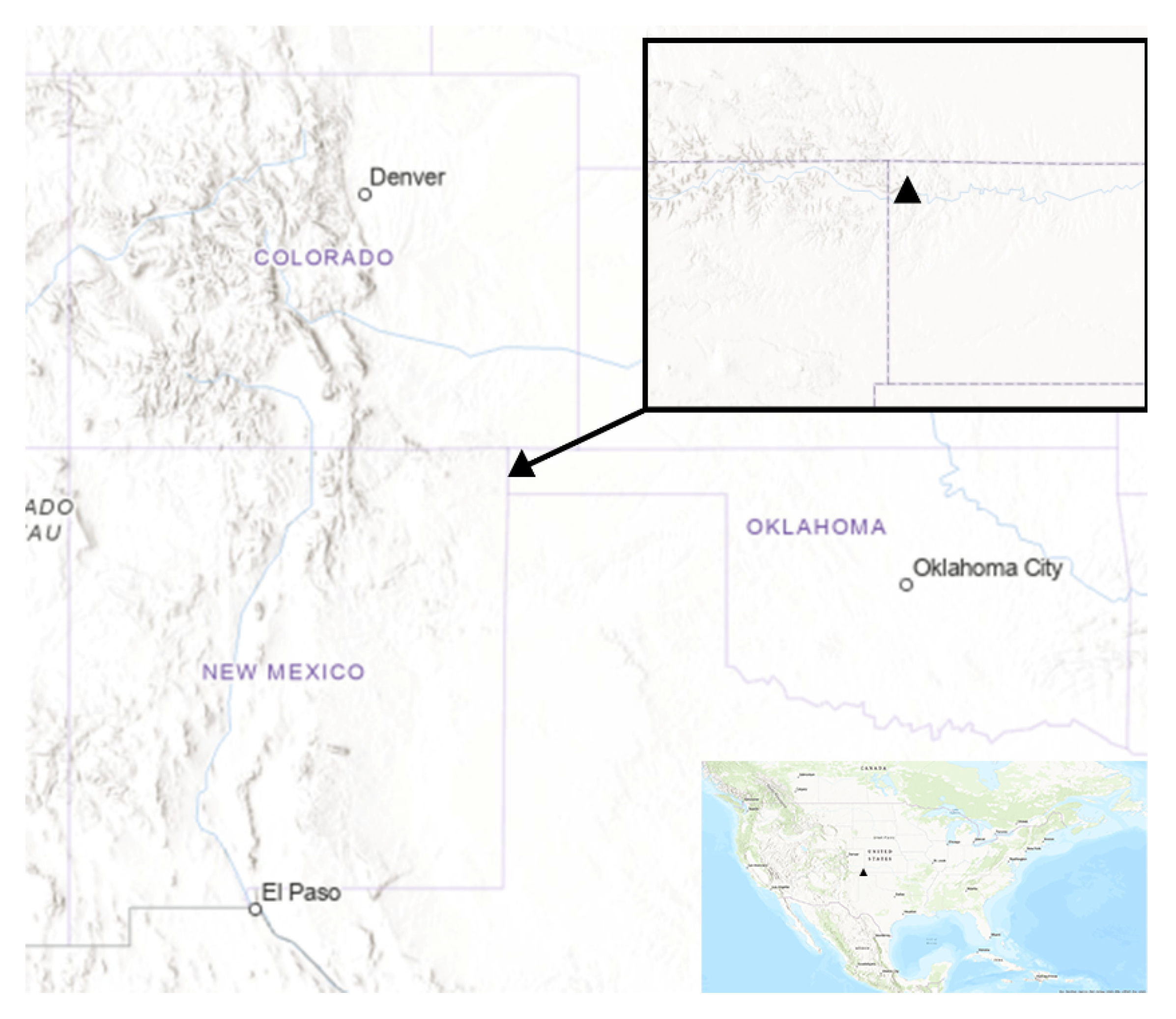
2.1. Case Study Location: Black Mesa, Oklahoma

The Black Mesa region is located in Cimarron County, in the panhandle of western Oklahoma, in the central portion of the United States (Figure 1). This scenic area contains rugged mesas and deeply incised canyons along both sides of the Cimarron River. Layer cake bedrock exposures mark the passage of geologic time from the dinosaur-bearing Triassic Period, through the Jurassic and Cretaceous Periods, and into the Quaternary Period. Wind and water erosion have carved shallow caves and overhangs suitable for animal and human occupation. The deep and often narrow canyons provide both vertical and horizontal habitats for the interfingering Plains and mountain foothills plant and animal resources. In contrast, the broad expanses offered by the High Plains bordering this region provided the grasslands for bison herds and easements for Precontact trade corridors and the famed Historic Santa Fe Trail.
This diverse geographical region has been occupied since the earliest Paleoindian periods (12,000–14,000 years ago). Various lines of evidence, including the discovery and sourcing of utilized obsidian, ceramic patterns, and rock art motifs, suggest that people from both the Southwest and Plains regions traveled here to make use of the numerous Dakota quartzite outcrops and other important natural resources that the landscape had to offer [29]. Among the many Precontact site types identified in the region, numerous rock shelter/overhang habitations and rock art sites, including both petroglyphs and pictographs, have been documented. Rock art sites have also been attributed to more recent post-contact habitations by both Indigenous and Euro-American inhabitants [30]. Other notable Precontact site types in the region include quarry sites, open camps, and stone ring sites. Stone rings have also been found located on high mesas overlooking North Carrizo Creek [31]. Those paired with a petroglyph-pecked boulder appear to have functioned in a line-of-sight signal fire system that has been documented to extend over ten miles north from the confluence of North Carrizo Creek with the Cimarron River into Colorado and westward along the Cimarron River into New Mexico [31], p. 49. Additional segments of this communication system, including their rock art and signal ring couplets, await documentation. The southwestern-most couplet provides two of the settings documented by this current study.

2.2. Scenarios for Data Acquisition in Remote, Rugged Environments

Data collection for the pilot study occurred at three types of locations. These are described below and generalized for use in field research contexts such as, but not limited to, archaeology and heritage management. The first example explores the capabilities of Skydio’s 3D Scan software to identify and model a 3D object within an area of interest. The second example emphasizes object avoidance during feature documentation: here, along vertical locations, including crags, small caves, and vegetation impingements. The final example tests the ability of the sUASs to plan and acquire data when conducted from a remote launching site: here, a feature located at the edge of a cliff lip.

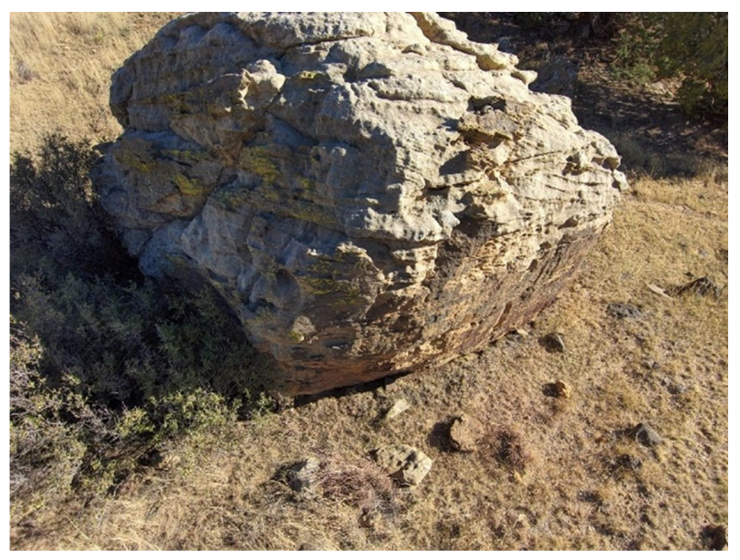
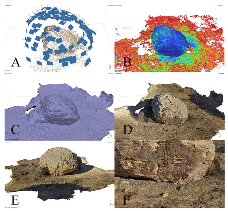
2.2.1. Scenario 1: Documenting a Freestanding Large Object

The objective in many fieldwork contexts is to reduce the amount of effort required for contextualizing an artifact or feature in a potentially significant location. At Black Mesa, petroglyphs were known to be located on one side of a large, rounded boulder, 34CI87 (Figure 2). While the petroglyphs are located close to the ground and could be documented with handheld photogrammetry, attempting to create a 3D model of the whole boulder with a traditional camera setup would be time-intensive, requiring researchers to carry ladders up and over mesas to reach the site. A fixed-height aerial flight overhead would inadequately document the undercut sides of the boulder, and combining a fixed-height survey with ground-based photogrammetry would, essentially, double the work. The boulder is an ideal candidate for volumetric flight planning, where the object of interest should be well defined by the 3D Scan software.

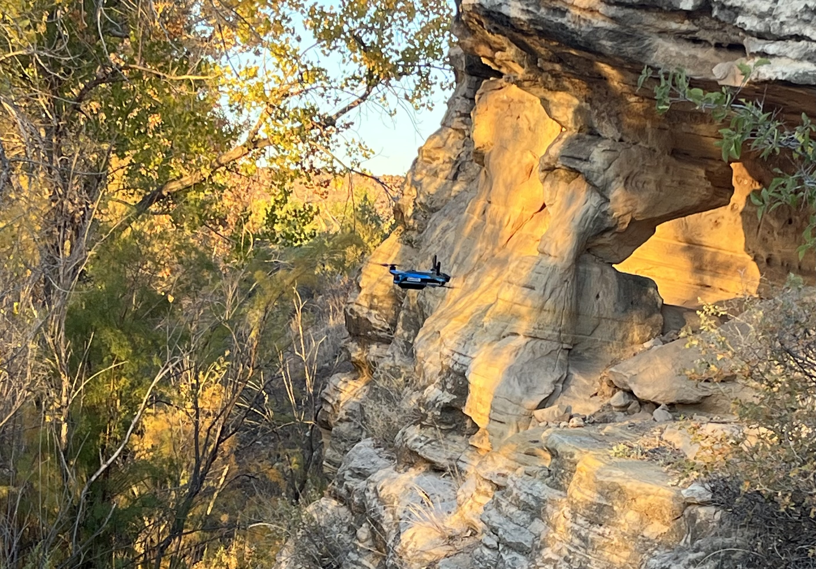
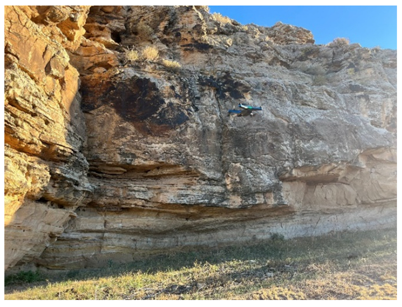
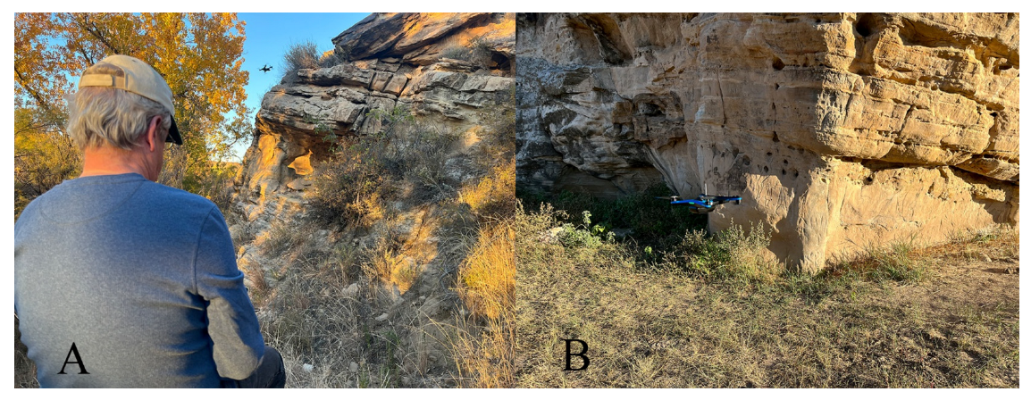
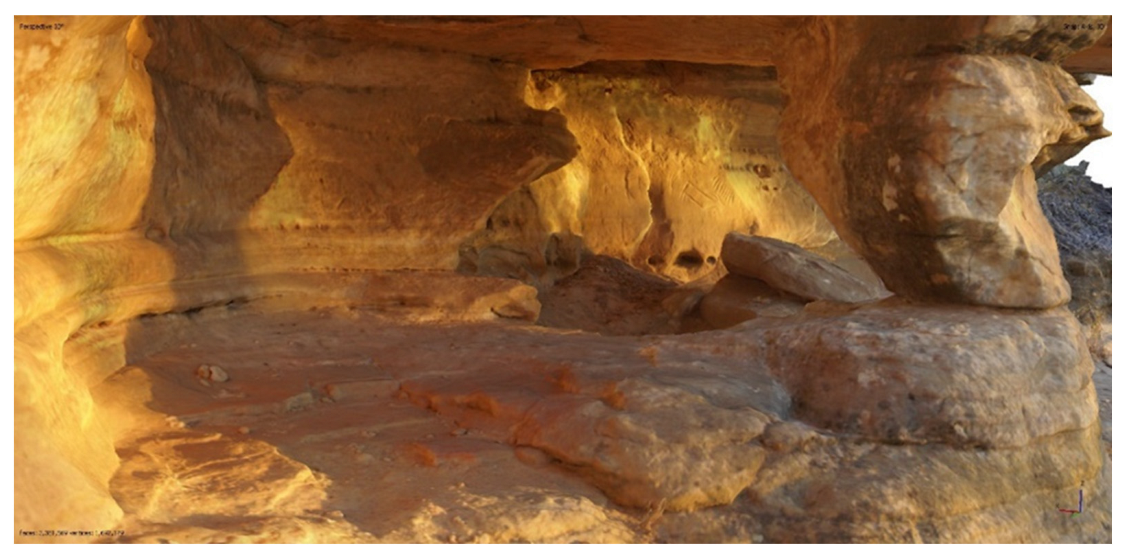
2.2.2. Scenario 2: Documenting Features along a Bluff Face

The second example explores multiple rock art panels located along a long sandstone bluff, collectively referred to as the Apple site (34CI63), and located on private land near Black Mesa State Park (Figure 3). At Apple 3 and Apple 4, two adjacent areas along the bluff, panels were set among uneven surfaces, including behind overhangs and in small shelters. A nearby river resulted in mature cottonwood and cedars that are growing close to the bluff, providing additional obstacles to consider beyond the challenges of creating a flight plan that would follow parallel to the wall. Beyond being a potentially GPS-denied environment, the vertical nature of the photogrammetry and the multiple objects that had to be avoided, from the rock face to vegetation, meant that obstacle avoidance would be particularly useful. We explored the ability to fly close to the ground, follow the vertical topography, and enter concavities of varying depths.

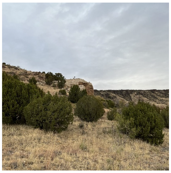
2.2.3. Scenario 3: Documenting Features on a High, Distant Promontory

Field documentation plans often change in the field as new locations of interest are identified and/or previous plans need to be modified. The physical act of accessing an appropriate launch point complicates field scenarios further. The final example explored the capabilities of the sUASs to determine and execute a flight plan remotely from the launch site and pilot. This implies areas of interest and features that would be hard to access with handheld camera photogrammetry. Referred to here as the Whitten site (34CI572), the test case focused on a set of rock features that served as a signal fire ring located on the lip of a rock cliff (Figure 4). The cliff itself juts out 10 m over the ground below; the example further served as an opportunity to include the surrounding area in the model.

3. Results

The three Black Mesa examples provide a range of scenarios, each requiring a different set of survey data, processing parameters, and results to consider. Despite the challenges that each provided, all flights using the sUASs resulted in high-quality photogrammetric models that standard commercial software could process. Documentation specifics are summarized below in Table 1, and additional photographs, videos, and details about the data acquisition and processing are archived as part of the Supplementary Materials.

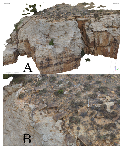
3.1. Data Collection and Processing

The portability of a sUAS, due to its small size and its relatively light weight, makes it an interesting candidate for backcountry archaeological fieldwork, which often requires long travel times on foot and/or over varied terrain. The ease of transport of the unit—its lightness and compactness, even with accessories and additional batteries—is advantageous for backcountry fieldwork, which often requires carrying equipment over significant distances. Here, the Black Mesa case study involved hiking and driving between three different locations, and set-up as well as flight planning could be accomplished within a series of minutes. Battery life, dependent on factors such as payload, temperature, and windspeed, fell within industry standards of about 25 min per flight.
Across all flights, we were able to conduct flight plans that included modeling the features of interest while in the field and without prior knowledge of the terrain (Table 1; Supplementary Materials, Reports). The processing reports (Supplementary Materials) show approximate camera location and image overlap associated with the survey data. The flexibility and utility of flight planning in the field proved useful here and likely in other field scenarios. Importantly, the Apple site examples would have been very difficult to document with a traditional drone and GNSS-dependent flight-planning application. The shielding effect of the rock bluff produces very poor GNSS locations, threatening a crash or fly-away, while the vertical nature of the flight path is not supported by most flight-planning applications. Flying the site manually remains an option but risks insufficient overlap and sidelap of photographs to generate a complete model, as well as requiring a skilled pilot. As the drone relies on its own internal GNSS, more accurate georeferencing would require ground control points and/or a total station with a local datum, depending on whether relative or absolute accuracy is needed (i.e., beyond a 2 m estimation). This is especially relevant if a researcher is planning to integrate the orthophotos or 3D models with other spatial datasets or when it is important to accurately know the precise geodetic positioning of a feature location.
Flying altitudes are set from the launch point, which is important for sites like Whitten, where the promontory and its signal fire ring are at different heights than the launch pad. The ability in Metashape to add in additional photographs from manual flights for Apple 3, Apple 4, and Whitten allowed for additional flexibility with field documentation approaches. While the coverage areas (30–500 m2) and corresponding number of photos (129–152) are small, considering the wide range of field applications for sUAS photogrammetry, they provided high-resolution imagery with sufficient overlap for 3D modeling and scaling. The resulting ground pixel resolution, which determines the smallest feature that can be detected in the model, ranged around a few millimeters per pixel, which is sufficient for visualizing petroglyphs of a variety of shapes and sizes and evaluating the thickness of the incisions at 34CI87 and Apple 3 and 4. At Whitten, this resolution allowed both the point of the cliff, where the archaeological feature was located, and the steep sides of the cliff, whose severity gives prominence and meaning to the feature, to be mapped together and with sufficient detail to provide good context (Figure 5).
Additional manual photos collected in two concentric rings further out provided better context for the surrounding landscape. Camera locations and associated locational error estimates were low at the top (<6 cm), with errors increasing with the manual photos of the sides of the point, taken further out and with less frequency (6–12cm error). One outlier image that was used to capture the whole of the point (rather than the model) in its surroundings increased the locational error estimate substantially.
Once processed in Metashape, the sUAS photographs produced high-quality, attractive models from a variety of angles that placed features of interest well within their locational contexts. Each Black Mesa model involved more than 20,000 tie-points with projections above 75,000, a 1:3 ratio that falls within standard recommendations for producing photogrammetry (Table 1). Tie-points relate to the quality of the network geometry and image matching, as well as the accuracy of the adjustment and reliability of the 3D points from which the sparse and dense point clouds are built [23]. Dense point clouds (.las) may be the final product, or they can be meshed and textured with projected images (.ply and .obj). Digital surface models and digital terrain models (DSM and DTM) can be created from the dense point cloud. DSM resolution typically was at or below 1cm per pixel, although that notably varies depending on the area of the model. With Whitten, the loss of model quality on the sides of the promontory was not important; knowing where the site was with reference to the cliff’s edge and the ability to visualize the context was the goal, not measuring the width or depth of one of the vertical cracks. Stones and their orientations are easily visible within the model, and mapping and analysis on a feature scale are possible. Figure 6 demonstrates these various products that were generated from the photographs; the full dataset is included in the Supplementary Materials.

3.2. Evaluation of sUAS Object Avoidance and Volumetric Flight Planning

The 360° obstacle avoidance associated with the drone proved robust across all test scenarios. For example, the sUASs planned around, flew close to, and yet still avoided the boulder, even in the face of 15 mph winds gusting to 20 mph. Object avoidance worked well in the relatively windless conditions at Apple 3 and 4, despite the various challenges the cliff presented. The flight plan at Apple 4 involved data collection between trees and the rock face and avoiding tree branches (Figure 6); no issues were encountered. The default for object avoidance on the drone was 3 ft (1 m); however, with the expanded firmware option, the obstacle avoidance tolerance could be set to as minimal as 4 in (10 cm). Tolerance levels were adjusted successfully at Apple 3 and Apple 4 to document the rock surface and areas of interest that were low to the ground (Figure 6).
In some instances, manual flying was still required. For example, at Apple 3, the drone would not enter a small alcove using the automated 3D Scan application but could be safely flown with obstacle avoidance in manual mode to take additional photographs. A similar approach was used for Apple 4 to include the floor of a small cave. The merged, final products resulted in a visually appealing model (Figure 7).
Overall, volumetric flight planning provided high-quality results, with a few caveats. All flight plans were sufficient to provide good overall context for both individual features and wider perspectives on the surrounding environments. With the boulder at 34CI87, for example, camera positions were sufficient at multiple heights and angles for good photogrammetric coverage, as shown in the high confidence levels of the boulder in the dense point cloud and mesh representations (Figure 8). Image residuals are limited primarily to the margins of the flight area, away from the boulder. Errors associated with camera location were especially present along the z-axis, expected with more vertical flight patterns, but should be noted at 65 cm (Supplementary Materials, Reports).
Volumetric flight planning differs substantially from how flight planning is typically conducted, at either a fixed height or by following surface elevations that are known and defined beforehand, known as terrain following. In contrast, here, the flight plan is based on a multilevel, multiangle exploration of 3D space. Verticality in features of interest is included that are not derived from a DEM or a set elevation; flight lines are programmed to capture all sides of a 3D object within the area of interest. This has important implications for generating sufficient overlap in objects and features that are desired to be part of the model.
As with other sUAS platforms of this size, 20 mph wind remains a good upper threshold for flying versus waiting for wind conditions to improve. For instance, strong 25 mph+ winds on the first afternoon of data acquisition postponed collection until the following morning. Grasses and small shrubs moving in the wind also create blurring in the models, providing a secondary consideration of where to document. The pilot needs to ensure that the points of interest are the ones being modeled in the proposed scan, rather than the drone diligently modeling surrounding vegetation.
While not an immediately apparent issue, battery limitations became a major hindrance for the remote documentation at Whitten. Our initial flight plan required a battery change mid-flight, where the drone would pause, return to the launch pad for a battery change, and then resume the mission. After the battery change, the drone had trouble relocating its area of interest (its starting point and orientation of the polygon); in other words, the launch area was too far away from the polygon, with the drone not having enough memory for its internal model, and the mission had to be aborted and re-tried as a single-battery mission. Both data sets were able to be merged along with a set of manual photographs taken from further outside the polygon for additional perspective. As with other flight planning software, flight time and battery specifications should always be considered to minimize these issues.

4. Discussion

Improvements in sUASs-based remote sensing have significantly expanded the userbase of drone-based imagery for archaeology and heritage applications [2,16,31]. Orthomosaics, DSMs and DEMs, and 3D point clouds are used regularly for terrain modeling and for documentation, prospection, and monitoring, as well as comprehensive landscape mapping [32,33]. Researchers across the field of sciences can document, map, and monitor an increasingly wide range of small and large features, retain good geodetic positioning, and mitigate logistical constraints [34]. Rural landscapes comprise a major sector of field-based research, with a real need for sUASs-based data acquisition, but those locations come with many challenges. Treed landscapes and other vertical features, such as rock walls and cliffs, interrupt flight paths and cell service. The potential for encountering stationery and moving objects, injuring people or animals, losing equipment, and dangerous weather conditions form central decision points on whether sUAS documentation happens or not. Austere, rugged, and vegetated environments introduce significant risk to field documentation, and there remains minimal conversation on how these may be avoided [35] for exception, especially beyond LiDAR [36,37]. As risk, cost, and quality of the field data define the limits of data collection, the issues involved in remote, rugged environments need to be addressed.
The Black Mesa scenarios presented occurred in contexts that field researchers encounter regularly but also present major hindrances to data collection. The self-contained object-avoidance technological advances in some drones allow archaeologists and other field researchers to access cultural and natural landscapes that they could not before (e.g., rough terrain, remote locations, and small-scale mixed feature landscapes). Once spatial boundaries are established, the drone performs self-navigation to create 3D environment models, including shallow caves and overhands, and incorporates risk avoidance around obstacles ranging in size from twigs to boulders, including cliff faces. The ability of a user to define a 3D space is also appealing, as vertical objects can be easily incorporated into the model without additional manual flights or handheld photographs. The type of flight planning that 3D Scan enabled can be performed “on the fly” without prior planning before going into the field. If and when a researcher finds an area or object of interest, the plan can be generated without the need to use cloud-based drone planning software and apps (e.g., DroneDeploy and UgCS) that require internet or cell service. Drone and processing software produced photogrammetric models and DEMs with resolutions of one centimeter or less across a variety of scenarios, including modeling free-standing objects, vertical flight paths, and remote flight plans. Further exploration could also be performed with open-source processing software or additional tie-point filtering [38]; data are available in the Supplementary Materials for such studies. Formal accuracy assessments [39,40] will improve the understanding of the absolute accuracy of the models. However, the level of visual and even metric analysis that most field researchers require may already be sufficient even without these comparisons; further, it is the access to rural, rugged, and GPS-denied environments permitted by these sUAS advances that are most relevant here. Creative use of drone hardware and software opens the potential for new applications in the field sciences to address the enduring problem of data acquisition in remote environments.
In summary, we find sUASs flexible, user-friendly, portable, and perhaps even cost-efficient for many projects and pilots. More importantly, perhaps, the technology associated with obstacle avoidance and on-the-fly volumetric mapping may help address the enduring challenges of fieldwork in rural areas and difficult places. Increasing accessibility to remote, rugged environments opens research potential to more novice pilots in novel places with exciting opportunities for discovery.

Supplementary Materials

The following supporting information can be downloaded at: https://www.mdpi.com/article/10.3390/rs16081418/s1, Supplementary Materials S1: Skydio 2+ drone system. Figure S1. Skydio 2+. Skydio 2+ on top of the carrying case which also contains the batteries and controller, in the field in Black Mesa State Park, Oklahoma. The case was also used as the launching and landing pad.

Author Contributions

Conceptualization, C.K.; methodology, M.D.W., C.K., L.C.B. and B.B.; investigation, M.D.W., C.K., B.B. and L.C.B.; resources, L.C.B. and B.B.; data curation, C.K.; writing—original draft, C.K.; writing—review and editing, M.D.W., B.B., L.C.B. and C.K.; visualization, M.D.W.; supervision, C.K.; project administration, C.K. and L.C.B.; funding acquisition, C.K. All authors have read and agreed to the published version of the manuscript.

Funding

This research was funded by the National Science Foundation (grant no. 2114235) as part of a SPARC Award. The Spatial Archaeometry Research Collaborations (SPARC) Program is based at the Center for Advanced Spatial Technologies at the University of Arkansas.

Data Availability Statement

Data and data products used in this assessment have been archived in Zenodo at the following DOIs: 10.5281/zenodo.8381415, 10.5281/zenodo.8381408, and 10.5281/zenodo.8381404. These include reports from the data capture (Skydio) and processing (Metashape); products, including additional images and videos of the three examples; and the raw and processed data associated with the boulder example, with geolocations removed. Requests for the original dataset should be submitted to the Oklahoma Archeological Survey for review.

Acknowledgments

The authors wish to thank Jackson Cothren, Hank Theiss, Wolfgang Alders, and Jennifer Lupu for their insight and edits on various stages of the manuscript. M.D.W. served as a drone pilot at Black Mesa.

Conflicts of Interest

The authors declare that they have no conflicts of interest.

References

  1. Campana, S. Drones in archaeology. State-of-the-art and future perspectives. Archaeol. Prospect. 2017, 24, 275–296. [Google Scholar] [CrossRef]
  2. Casana, J. Rethinking the landscape: Emerging approaches to archaeological remote sensing. Annu. Rev. Anthropol. 2021, 50, 167–186. [Google Scholar] [CrossRef]
  3. Duffy, J.P.; Cunliffe, A.M.; DeBell, L.; Sandbrook, C.; Wich, S.A.; Shutler, J.D.; Myers-Smith, I.H.; Varela, M.R.; Anderson, K. Location, location, location: Considerations when using lightweight drones in challenging environments. Remote Sens. Ecol. Conserv. 2018, 4, 7–19. [Google Scholar] [CrossRef]
  4. Jordan, B. Collecting field data in volcanic landscapes using small UAS (sUAS)/drones. J. Volcanol. Geotherm. Res. 2019, 385, 231–241. [Google Scholar] [CrossRef]
  5. Smith, S.L. Drones over the “Black Desert”: The advantages of rotary-wing UAVs for complementing archaeological fieldwork in the hard-to-access landscapes of preservation of North-Eastern Jordan. Geosciences 2020, 10, 426. [Google Scholar] [CrossRef]
  6. Cowley, D.C.; Moriarty, C.; Geddes, G.; Brown, G.L.; Wade, T.; Nichol, C.J. UAVs in context: Archaeological airborne re-cording in a national body of survey and record. Drones 2018, 2, 2. [Google Scholar] [CrossRef]
  7. Gutierrez, G.; Searcy, M.T. Introduction to the UAV special edition. SAA Archaeol. Rec. 2016, 16, 6–9. [Google Scholar]
  8. Hill, A.C.; Rowan, Y.M. The Black Desert Drone Survey: New Perspectives on an Ancient Landscape. Remote Sens. 2022, 14, 702. [Google Scholar] [CrossRef]
  9. Hodgson, J.C.; Mott, R.; Baylis, S.M.; Pham, T.T.; Wotherspoon, S.; Kilpatrick, A.D.; Raja Segaran, R.; Reid, I.; Terauds, A.; Koh, L.P. Drones count wildlife more accurately and precisely than humans. Methods Ecol. Evol. 2018, 9, 1160–1167. [Google Scholar] [CrossRef]
  10. Jiménez López, J.L.; Mulero-Pázmány, M. Drones for conservation in protected areas: Present and future. Drones 2019, 3, 10. [Google Scholar] [CrossRef]
  11. Librán-Embid, F.; Klaus, F.; Tscharntke, T.; Grass, I. Unmanned aerial vehicles for biodiversity-friendly agricultural landscapes—A systematic review. Sci. Total Environ. 2020, 732, 139204. [Google Scholar] [CrossRef]
  12. O’Driscoll, J. Landscape applications of photogrammetry using unmanned aerial vehicles. J. Archaeol. Sci. Rep. 2018, 22, 32–44. [Google Scholar] [CrossRef]
  13. Olson, K.G.; Rouse, L.M. A beginner’s guide to mesoscale survey with quadrotor-UAV systems. Adv. Archaeol. Pract. 2018, 6, 357–371. [Google Scholar] [CrossRef]
  14. Wich, S.A.; Koh, L.P. Conservation Drones: Mapping and Monitoring Biodiversity; Oxford University Press: Oxford, UK, 2018. [Google Scholar] [CrossRef]
  15. Coops, N.C.; Goodbody, T.R.H.; Cao, L. Four steps to extend drone use in research. Nature 2019, 572, 433–435. [Google Scholar] [CrossRef] [PubMed]
  16. Hill, A.C. Economical drone mapping for archaeology: Comparisons of efficiency and accuracy. J. Archaeol. Sci. Rep. 2019, 24, 80–91. [Google Scholar] [CrossRef]
  17. Magnani, M.; Douglass, M.; Schroder, W.; Reeves, J.; Braun, D.R. The digital revolution to come: Photogrammetry in archaeological practice. Am. Antiq. 2020, 85, 737–760. [Google Scholar] [CrossRef]
  18. Brady, L.M.; Hampson, J.; Sanz, I.D. Recording rock art: Strategies, challenges, and embracing the digital revolution. In The Oxford Handbook of the Archaeology and Anthropology of Rock Art; David, B., McNiven, I.J., Eds.; Oxford Academic: Oxford, UK, 2019. [Google Scholar] [CrossRef]
  19. Mark, R.; Billo, E. Low altitude unmanned aerial photography to assist in rock art studies. SAA Archaeol. Rec. 2016, 16, 14–16. [Google Scholar]
  20. Berquist, S.; Spence-Morrow, G.; Gonzalez-Macqueen, F.; Rizzuto, B.; Yépez Álvarez, W.; Bautista, S.; Jennings, J. A new aerial photogrammetric survey method for recording inaccessible rock art. Digit. Appl. Archaeol. Cult. Herit. 2018, 8, 46–56. [Google Scholar] [CrossRef]
  21. Simek, J.; Alvarez, S.; Cressler, A. Discovering ancient cave art using 3D photogrammetry: Pre-contact Native American mud glyphs from 19th Unnamed Cave, Alabama. Antiquity 2022, 96, 662–678. [Google Scholar] [CrossRef]
  22. Laugier, E.J.; Casana, J. Integrating satellite, UAV, and ground-based remote sensing in archaeology: An exploration of pre-modern land use in Northeastern Iraq. Remote Sens. 2021, 13, 5119. [Google Scholar] [CrossRef]
  23. Orsini, C.; Benozzi, E.; Williams, V.; Rossi, P.; Mancini, F. UAV photogrammetry and GIS interpretations of extended ar-chaeological contexts: The case of Tacuil in the Calchaquí area (Argentina). Drones 2022, 6, 31. [Google Scholar] [CrossRef]
  24. Jorayev, G.; Wehr, K.; Benito-Calvo, A.; Njau, J.; de la Torre, I. Imaging and photogrammetry models of Olduvai Gorge (Tanzania) by Unmanned Aerial Vehicles: A high-resolution digital database for research and conservation of Early Stone Age sites. J. Archaeol. Sci. 2016, 75, 40–56. [Google Scholar] [CrossRef]
  25. Lim, J.S.; Gleason, S.; Strehlau, H.; Church, L.; Nicolai, C.; Church, W.; Jones, W. Alaska Native allotments at risk: Technological strategies for monitoring erosion and informing solutions in southwest Alaska. Land 2023, 12, 248. [Google Scholar] [CrossRef]
  26. Vilbig, J.M.; Sagan, V.; Bodine, C. Archaeological surveying with airborne LiDAR and UAV photogrammetry: A comparative analysis at Cahokia Mounds. J. Archaeol. Sci. Rep. 2020, 33, 102509. [Google Scholar] [CrossRef]
  27. Cerasoni, J.N.; do Nascimento Rodrigues, F.; Tang, Y.; Hallett, E.Y. Do-it-yourself digital archaeology: Introduction and practical applications of photography and photogrammetry for the 2D and 3D representation of small objects and artefacts. PLoS ONE 2022, 17, e0267168. [Google Scholar] [CrossRef] [PubMed]
  28. Williamson, M. Skydio 2+ enterprise kit with 3D Scan. Technol. Archit. Des. 2022, 6, 248–250. [Google Scholar] [CrossRef]
  29. Larrick, D.; Drass, R.; Bement, L.C. Corn Cobs and Drive Lanes: NRHP Testing of Three Sites in the Black Mesa Region, Cimarron County, Oklahoma, Project No. 19-201; Tech Rep, Research Series No. 6, Oklahoma Archeological Survey; The University of Oklahoma: Norman, OK, USA, 2020. [Google Scholar]
  30. Ramos Berrios, A.N.; Bethke, B.; Bement, L.C. Tipi-Toeing across the Uplands: Pedestrian Survey along The Cimarron River/High Plains Border, Northwest Cimarron County, Oklahoma; Oklahoma Archeological Survey Research Series; The University of Oklahoma: Norman, OH, USA, 2022; Volume 12. [Google Scholar]
  31. Bement, L.C.; Carmichael, C.R. From Top to Bottom: Pedestrian Survey of the Black Mesa Region, Cimarron County, Okla-Homa. Tech. Rep; Archeological Resource Survey Report No. 48, Oklahoma Archeological Survey; The University of Oklahoma: Norman, OK, USA, 2003. [Google Scholar]
  32. Adamopoulos, E.; Rinaudo, F. UAS-based archaeological remote sensing: Review, meta-analysis and state-of-the-art. Drones 2020, 4, 46. [Google Scholar] [CrossRef]
  33. Casana, J.; Laugier, E.J.; Hill, A.C.; Reese, K.M.; Ferwerda, C.; McCoy, M.D.; Ladefoged, T. Exploring archaeological landscapes using drone-acquired lidar: Case studies from Hawai’i, Colorado, and New Hampshire, USA. J. Archaeol. Sci. Rep. 2021, 39, 103133. [Google Scholar] [CrossRef]
  34. de Reu, J.; Plets, G.; Verhoeven, G.; De Smedt, P.; Bats, M.; Cherretté, B.; De Maeyer, W.; Deconynck, J.; Herremans, D.; Laloo, P.; et al. Towards a three-dimensional cost-effective registration of the archaeological heritage. J. Archaeol. Sci. 2013, 40, 1108–1121. [Google Scholar] [CrossRef]
  35. Krátký, V.; Petráček, P.; Nascimento, T.; Čadilová, M.; Škobrtal, M.; Stoudek, P.; Saska, M. Safe documentation of historical monuments by an autonomous unmanned aerial vehicle. ISPRS Int. J. Geoinf. 2021, 10, 738. [Google Scholar] [CrossRef]
  36. Masini, N.; Abate, N.; Terenzio Gizzi, F.; Vitale, V.; Amodio, A.M.; Sileo, M.; Biscione, M.; Lasaponara, R.; Bentivenga, M.; Cavalcante, F. UAV LiDAR based approach for the detection and interpretation of archaeological micro topography under canopy—The rediscovery of Perticara (Basilicata, Italy). Remote Sens. 2022, 14, 6074. [Google Scholar] [CrossRef]
  37. Ullman, M.; Laugomer, B.; Shicht, I.; Langford, B.; Ya’aran, S.; Wachtel, I.; Frumkin, A.; Davidovich, U. Formation processes and spatial patterning in a late prehistoric complex cave in northern Israel informed by SLAM-based LiDAR. J. Archaeol. Sci. Rep. 2023, 47, 103745. [Google Scholar] [CrossRef]
  38. Mousavi, V.; Varshosaz, M.; Rashidi, M.; Li, W. A new multi-criteria tie point filtering approach to increase the accuracy of UAV photogrammetry models. Drones 2022, 6, 413. [Google Scholar] [CrossRef]
  39. Barba, S.; Barbarella, M.; Di Benedetto, A.; Fiani, M.; Gujski, L.; Limongiello, M. Accuracy assessment of 3D photogrammetric models from an unmanned aerial vehicle. Drones 2019, 3, 79. [Google Scholar] [CrossRef]
  40. Jalandoni, A.J.; Domingo, I.; Taçon, P.S.C. Testing the value of low-cost Structure-from-Motion (SfM) photogrammetry for metric and visual analysis of rock art. J. Archaeol. Sci. Rep. 2018, 17, 605–616. [Google Scholar] [CrossRef]
Figure 1. Black Mesa region, Oklahoma, in the central United States. The Black Mesa study region is in western Oklahoma, where this study was conducted. The insert shows the location along the Cimarron River and the easternmost extent of the Rocky Mountains.
Remotesensing 16 01418 g001
Figure 2. Boulder used for Scenario 1, located near Black Mesa, Oklahoma. The boulder is approximately 5.5 m in diameter and 3.2 m in height. The rock art is registered as site 34CI87 with the Oklahoma Archeological Survey.
Remotesensing 16 01418 g002
Figure 3. Overhangs and niches containing petroglyphs at 34CI63, known as Apple, used in Scenario 2. 34CI63 is located on private property near Black Mesa State Park, Oklahoma. The Skydio 2+ is visible in the top middle portion of the photo. The dimensions of the Skydio 2+, with battery and with antennas lifted, are 229 mm (width) × 279 mm (length) × 126 mm (height).
Remotesensing 16 01418 g003
Figure 4. Promontory projection at 34CI572 that holds a circular signal fire feature that was documented in Scenario 3. Note the person (L. C. B.) standing on top of the outcrop, between the bushes and the edge.
Remotesensing 16 01418 g004
Figure 5. Image and model of Whitten (34CI572). (A) Photograph still of the signal fire ring collected by the Skydio 2+. (B) Final photogrammetric model of Whitten.
Remotesensing 16 01418 g005
Figure 6. Demonstrations of the sUAS obstacle avoidance capabilities. (A): The Skydio 2+ drone flying between a stand of trees and a cliff. (B): Drone collecting data 30 cm above ground.
Remotesensing 16 01418 g006
Figure 7. Model of a cliff-side cave at Apple 4 (34CI63). The drone was able to enter and document the cave environment using 3D Scan; however, manual photographs also had to be taken to include the floor.
Remotesensing 16 01418 g007
Figure 8. Results of data collection and processing of the boulder (34CI87) used in Scenario 1. (A) Camera locations associated with the data acquisition of the boulder. (B) Confidence levels of the boulder dense point cloud from low (blue) to high (red). (C) Mesh of boulder, with 1,992,750 faces and 997,049 vertices. (D) Mesh of boulder with texture. (E) The final model of B. (F) Close-up of petroglyphs on a boulder. Raw and processed data are available in Supplementary Materials, Boulder Example.
Remotesensing 16 01418 g008
Table 1. Summary of photogrammetric data collection and processing results associated with the sUAS examples at Black Mesa, Oklahoma.
BoulderApple 3Apple 4Whitten
Total number of images129152124152
Autonomous imagesUnrecorded132114112
Manual imagesUnrecorded19945
Flying altitude (m)3.221.391.494.44
Ground resolution (mm/pix)1.530.730.842.9
Coverage area (m2)25429.733494
Tie points36,31121,81958,56624,925
Projections94,69681,285155,40876,739
Reprojection error (pix)0.460.570.440.34
Model faces1,992,7508,655,1663,381,5696,443,710
Model vertices997,0494,330,6421,692,1793,229,016
DSM resolution (cm/pix)1.070.290.491.05
DSM point density (points/cm2)0.8712.104.110.92
File size (MB)115.98391.18170.02359.61
Disclaimer/Publisher’s Note: The statements, opinions and data contained in all publications are solely those of the individual author(s) and contributor(s) and not of MDPI and/or the editor(s). MDPI and/or the editor(s) disclaim responsibility for any injury to people or property resulting from any ideas, methods, instructions or products referred to in the content.

