Article

A Continuous B2b-PPP Model Considering Interruptions in BDS-3 B2b Orbits and Clock Corrections as Well as Signal-in-Space Range Error Residuals

1
School of Transportation, Southeast University, Nanjing 211189, China
2
School of Instrument Science and Engineering, Southeast University, Nanjing 210096, China
*
Author to whom correspondence should be addressed.
These authors contributed equally to this work.
Remote Sens. 2025, 17(4), 618; https://doi.org/10.3390/rs17040618
Submission received: 6 January 2025 / Revised: 7 February 2025 / Accepted: 10 February 2025 / Published: 11 February 2025
(This article belongs to the Special Issue Advanced Multi-GNSS Positioning and Its Applications in Geoscience)

Abstract

:
In 2020, BDS-3 began broadcasting high-precision positioning correction products through B2b signals, effectively addressing the limitations of ground-based augmentation. However, challenges such as the “south wall effect” from geostationary orbit (GEO) satellites, issues of data (IOD) mismatch, and signal priority conflicts often result in interruptions and anomalies during real-time positioning with the B2b service. This paper proposes a continuous B2b-PPP (B2b signal-based Precise Point Positioning) model that incorporates signal-in-space range error (SISRE) residuals and predictions for B2b orbits and clock corrections to achieve seamless, high-precision continuous positioning. In our experiments, we first analyze the characteristics of B2b SISRE for both BDS-3 and GPS. We then evaluate the positioning accuracy of several models, B2b-PPP, EB2b-PPP, PB2b-PPP, EB2bS-PPP, and PB2bS-PPP, through simulated and real dynamic experiments. Here, ‘E’ indicates the direct utilization of the previous observation corrections from B2b before the signal interruption, ‘P’ represents B2b prediction products, and ‘S’ signifies the incorporation of the SISRE residuals. The results show that EB2b-PPP exhibits significant deviations as early as 10 min into a B2b signal interruption. Both PB2b-PPP and EB2bS-PPP demonstrate comparable performances, with PB2bS-PPP emerging as the most effective method. Notably, in real dynamic experiments, PB2bS-PPP maintains positioning accuracy in the E/N directions like B2b-PPP, even after 40 min of signal interruption, ensuring continuous and stable positioning upon signal restoration. This achievement significantly enhances the capability for high-precision continuous positioning based on B2b signals.

1. Introduction

PPP (Precise Point Positioning) technology enables high-precision, absolute positioning globally by accurately correcting various error sources. Its key advantage lies in its flexibility and convenience, as it only requires a single receiver [1,2]. However, traditional PPP often depends on post-processing with precise products or real-time precise orbit and clock corrections broadcast by ground networks [3,4]. This reliance limits its widespread application in areas such as smart transportation, precision agriculture, and high-precision positioning in remote regions like deserts and at sea. Satellite-based augmentation services (SBASs), which broadcast precise products via satellites, have a reduced dependency on ground infrastructure, thereby providing vital support for large-scale, high-precision PPP [5,6].
With the development of BDS-3 (Beidou Navigation Satellite System), China officially released the PPP-B2b interface document in 2020 [7]. This document specifies the use of B2b signals from three geostationary orbit (GEO) satellites (C59 to C61) within the BDS-3 constellation as the data broadcast channel. These signals transmit correction parameters for BDS-3 and Global Positioning Systems (GPSs), including precise satellite orbits and clock corrections relative to the broadcast ephemeris (BRDC), precise differential code bias (DCB), and the user range accuracy index, to users in China and the surrounding regions (from 75°E to 135°E longitude and 10°N to 55°N latitude), as well as in areas extending up to 1000 km above the Earth’s surface [8]. By receiving these precise satellite orbits and clock corrections, users can modify the corresponding BRDC to generate a real-time precise ephemeris, enabling free real-time high-precision positioning, velocity measurements, and timing services [9,10,11,12]. Analyses and evaluations indicate that B2b-PPP (B2b signal-based Precise Point Positioning) can provide centimeter-level accuracy in static conditions and decimeter-level accuracy in dynamic conditions [13,14,15]. On 23 January 2023, Galileo High Accuracy Service (HAS) also announced the provision of high-precision orbit, clock, and other products for both GPS and Galileo through the Galileo E6B signal and network, enabling high-precision PPP on a global scale [16,17].
In SBAS-based dynamic high-precision positioning applications, the continuity of PPP depends on the orbit and clock products remaining within their “nominal validity period”. Unlike the global service provided by Galileo HAS, the B2b service requires at least one visible GEO satellite to ensure observation continuity. However, since the GEO satellites are fixed in position over the equator (at 80°E, 110.5°E, and 140°E), users in the northern hemisphere, especially in high-latitude regions, experience lower satellite elevation angles [18,19]. This makes the signal more susceptible to obstruction by tall buildings, mountains, or vegetation, resulting in signal instability or loss, and leading to the “south wall effect” (the southern occlusion issue of GEO satellite services in the northern hemisphere) [20]. In terms of service integrity, the B2b broadcast’s bandwidth is 500 bps. Due to the limited downlink bandwidth of the satellite signal, the B2b service prioritizes the broadcast of BDS-3 corrections, which may limit the broadcast of GPS corrections and affect data completeness [21]. Regarding signal matching accuracy, the receiver must strictly match the IOD (issue of data) of the B2b signal to ensure that the correct orbits and clock corrections are being used. Any IOD mismatch could result in the receiver using outdated or inconsistent data, thereby impacting positioning accuracy [22].
Therefore, in practical applications, it is crucial to minimize the risk of B2b-PPP system failure caused by B2b signal packet loss due to the “south wall effect”, broadcast prioritization, and matching errors. The key lies in effectively detecting anomalies in the B2b signals and predicting B2b products during abnormal conditions [23]. In our previous research, we established a quadratic anomaly detection mechanism based on epoch difference and median absolute deviation, leveraging the timing characteristics of B2b orbits and clock corrections [23]. Consequently, this paper focuses on the effective prediction of B2b corrections. According to CSNO 2020, the nominal validity period of DCB is 86,400 s, the nominal validity time for satellite orbits corrections is 96 s, and for clock corrections, it is only 12 s [7]. Therefore, the prediction of B2b products primarily involves forecasting orbits and clock corrections [24]. Studies have shown that using the last epoch product before a B2b interruption can maintain positioning accuracy for up to 10 min, but this empirical threshold is insufficient in terms of usability and reliability for real-time positioning [25]. Our earlier research quantitatively analyzed the temporal characteristics of these corrections for BDS-3 and GPS in B2b, and we developed differentiated prediction models to address the discontinuity in B2b-PPP caused by anomalies. The experimental results indicate that the prediction accuracy is significantly affected by the continuous observation arc of B2b. Under typical conditions, the effective prediction duration can reach 20–30 min, during which time the positioning accuracy is better than 0.1 m [23]. However, as time progresses, the predicted values gradually deviate from the true values, leading to a decline in positioning accuracy. Additionally, after long signal interruptions, when the signal is restored, significant differences between the predicted and real-time orbits/clock corrections can result in substantial positioning jumps.
The decline in precision and the positioning jumps observed during the reacquisition of B2b signals are primarily due to the degradation of the accuracy of the forecast products over time, leading to significant discrepancies from the actual B2b products. To address these issues, it is crucial to absorb these residual errors effectively. SISRE (signal-in-space range error), as a comprehensive metric, is typically used to reflect the accuracy of orbits and clock products or to indicate the overall error in satellite signals [26]. Therefore, SISRE parameters can be incorporated into positioning to absorb residual errors and enhance accuracy. Existing studies have demonstrated that incorporating SISRE parameters into BRDC-based high-precision PPP improves accuracy [27,28]. Similarly, studies indicate that for B2b signals, the SISRE standard deviation (STD) values range from 1.6 cm to 30.5 cm for BDS-3, with an average of 4.9 cm. For GPS, the values vary between 2.5 cm and 33.0 cm, with an average of 7.1 cm. Introducing SISRE parameters into B2b-PPP can effectively absorb residual errors in B2b orbits and clock corrections, thereby improving B2b-PPP accuracy [22].
In this paper, we propose incorporating SISRE parameters to effectively absorb forecast residuals based on predicted orbits and clock corrections. Additionally, recognizing the variations in predicted orbit and clock corrections accuracy among different satellites or satellite pairs, we have developed a stochastic model that incorporates SISRE accuracy. By reconstructing the B2b-PPP observation model and the stochastic model, we aim to achieve continuous and stable positioning during B2b signal interruptions. In the following sections, we will first provide a detailed introduction to the mathematical models. During the experiments, we analyzed the statistical characteristics of SISRE and validated the effectiveness of our proposed models through simulated kinematic positioning experiments and real-world kinematic tests. Finally, we present our conclusions.

2. Materials and Methods

In this section, we will first introduce the methodology for reconstructing precise ephemerides based on B2b signals. Next, we will present our previously proposed models for B2b orbits and clock predictions. Additionally, we will outline the assessment method for SISRE and formulate a B2b-PPP observation model along with a stochastic model that incorporates SISRE residuals.

2.1. Precise Orbits and Clock Generation Based on B2b Corrections

Currently, the B2b signal primarily broadcasts products including orbits and clock corrections for BDS-3 and GPS satellites, as well as DCB products for BDS-3. The orbit corrections refine the BRDC to obtain precise real-time satellite coordinates. These corrections include radial, along-track, and cross-track components and must be converted to the Earth Centered Earth Fixed (ECEF) coordinate system before application. For clock corrections, B2b directly refines the BRDC clock offset. The method for generating precise real-time B2b orbits and clock products is as follows [7]:
{ X p r e c s = X b r d c s + [ e r a d i a l e a l o n g e c r o s s ] δ O e r a d i a l = r | r | ,   e c r o s s = r × r ˙ | r × r ˙ | ,   e a l o n g = e c r o s s × e r a d i a l δ O = [ d O r a d i a l d O a l o n g d O c r o s s ] T d t p r e c s = d t b r d c s d c l k / c
where X p r e c s represents the real-time precise satellite position vector after applying B2b orbit corrections to the BRDC, and X b r d c s is the satellite position vector calculated from the BRDC. The unit vectors e r a d i a l , e a l o n g , and e c r o s s correspond to the radial, along-track, and cross-track directions, respectively. The vector δ O is the B2b orbit corrections vector in the ECEF coordinate frame; d O r a d i a l , d O a l o n g , and d O c r o s s represent B2b orbit corrections in the radial, along-track, and cross-track directions, respectively. Furthermore, r and r ˙ are the satellite’s position and velocity vectors in the ECEF coordinate system. The term d t p r e c s donates the corrected real-time precise satellite clock offset, while d t b r d c s is the satellite clock offset calculated from the BRDC, d c l k represents the B2b clock corrections, and c is the speed of light in the vacuum.

2.2. B2b Orbits and Clock Corrections Prediction Model

Our preliminary research indicates that BDS-3 orbit corrections typically remain within 0.2 m and do not vary significantly. Therefore, when a signal interruption occurs, it is recommended to directly use the value from the last epoch as the predicted correction. In contrast, GPS orbits corrections exhibit larger variations and more frequent jumps. Instead, we employ a quadratic polynomial to predict GPS orbit corrections. For clock corrections, long-term observational data reveal that BDS-3 clock corrections follow a pattern more aligned with a linear polynomial. The variations in GPS satellites are more complex, sometimes showing strong stability while at other times exhibiting high-frequency fluctuations. Due to this irregularity, the average value of the last few epochs is used as the predicted correction. In summary, during signal interruptions, the following prediction models are applied for B2b orbits and clock corrections [23]:
{ d X C = d X l a s t C d X G = a 0 + a 1 Δ t + a 2 Δ t 2 d c l k C = b 0 + b 1 Δ t d c l k G = 1 N i = 0 N d c l k l a s t i G
where C and G represent BDS-3 and GPS, respectively, while d X C and d X G denote the predicted orbits corrections, and d c l k C and d c l k G denote the predicted clock corrections. The subscript l a s t indicates the last observation epoch, l a s t i represents the previous i epochs, and Δ t is the difference between the predicted epoch and the reference epoch. a 0 and a 1 are polynomial coefficients for GPS orbit prediction; b 0 and b 1 are polynomial coefficients for BDS-3 clock prediction. In practical applications, the polynomial coefficients can be fitted using the least squares method.

2.3. Assessment of B2b SISRE for BDS-3 and GPS

To evaluate the quality of B2b orbits and clock products, the international GNSS service (IGS) final precise ephemeris is commonly used as a reference for analyzing the accuracy of the corrected satellite orbits and clock data. SISRE quantifies the overall impact of orbits and clock errors on the user’s line of sight, serving as a key metric for GNSS public services [26,28]. The SISRE for BDS and GPS can be calculated by combining the radial, along-track, and cross-track components of orbit errors with clock errors, as follows:
S I S R E = { ( 0.98 d r a d i a l c δ t s ) 2 + ( d a l o n g 2 + d c r o s s 2 ) / 54 B D S ( M E O ) ( 0.99 d r a d i a l c δ t s ) 2 + ( d a l o n g 2 + d c r o s s 2 ) / 127 B D S ( I G S O ) ( 0.98 d r a d i a l c δ t s ) 2 + ( d a l o n g 2 + d c r o s s 2 ) / 49 G P S
where d r a d i a l , d a l o n g , and d c r o s s represent the radial, along-track, and cross-track orbits error, respectively, while δ t s denotes the clock error.
It is important to note that when calculating orbit errors, the B2b orbit corrections for BDS-3 are centered on the antenna phase center (APC) of the B3I frequency, while for GPS, they are centered on the APC of the L1/L2 ionosphere-free (IF) combination. In contrast, the satellite coordinates of the final precise products are based on the satellite’s center of mass (CoM). Consequently, BDS-3 satellites require corrections using the phase center offset (PCO) products provided by CSNO, whereas GPS satellites need corrections based on the igs14.atx file corresponding to the relevant GPS week [29,30]. These adjustments eliminate discrepancies between the final precise orbits and B2b orbit products, facilitating the calculation of differences between the satellite orbit products.
When comparing B2b clock products with precise clock products, it is essential to consider the differences in frequency references and time scales. The reference signals used by IGS’s precise clock products are based on a dual-frequency IF combination. Specifically, GPS utilizes the L1/L2 IF combination as its reference signal, which aligns with the B2b reference signals. In contrast, the precise clock products of BDS-3 from IGS typically use the B1I/B3I IF combination as their reference signal, with the B2b clock corrections referenced to B3I. To standardize the clock offset benchmarks across different products, appropriate DCB corrections are necessary. This allows for the calculation of the single-difference (SD) clock offset between B2b and the precise clock products. Additionally, systematic errors in the time scales of different products, along with fluctuations in various time references, can introduce certain systematic biases into the SD satellite clock offsets for each system. To address this issue, a double-difference (DD) approach is commonly employed, involving the subtraction of the SD clock offset of a reference satellite [31]. After evaluating the orbits and clock errors, the SISRE can be calculated using Equation (3).

2.4. B2b-PPP Observation Model Incorporating SISRE Residuals

The IF model is one of the most widely used observation models for PPP. It takes advantage of the inverse square relationship between ionospheric delay and frequency, using dual-frequency observations to eliminate the influence of the first-order ionospheric term. This section first outlines the basic observation model for PPP and then constructs the IF B2b-PPP model. Building on this foundation, an improved observation model is introduced by incorporating the SISRE residuals. The basic observation model is as follows [32]:
{ P r , j s = ρ r s + c d t r c d t s + M r s T w + I r , j s + ( d r , j d j s ) + e r , j s φ r , j s = ρ r s + c d t r c d t s + M r s T w I r , j s + ( λ j N r , j s + b r , j b j s ) + ε r , j s
where P and φ are the pseudo-range and carrier phase measurement, s and r represent the satellite and receiver, respectively, and ρ denotes the geometric distance between them. j is the corresponding carrier frequency. d t r and d t s represent the clock errors in the satellite and receiver, while M r s and T w correspond to the mapping function for zenith tropospheric wet delay and the associated zenith tropospheric wet delay. I r , j s represents the ionospheric delay, and d r , j and d j s denote the pseudo-range hardware delays for the receiver and satellite. b r , j and b j s are the carrier phase hardware delays for the receiver and satellite, with λ j representing the corresponding carrier wavelength and N r , j s representing the ambiguity. e r , j s and ε r , j s denote the pseudo-range and carrier phase noise, respectively. Other modellable errors, such as relativistic effects, Earth rotation effects, satellite antenna PCO and phase center variations (PCVs), phase wrapping, solid tide effects, and dry tropospheric delay, can be corrected using corresponding models, which are not detailed here.
In the B2b service, BDS-3 satellite clock corrections are referenced to the civil navigation (CNAV1) BRDC products, using the B3I frequency as the baseline. For GPS satellite clock corrections, the reference is the L1/L2 IF combination provided by the legacy navigation (LNAV) BRDC. Therefore, for users of the IF PPP service utilizing the B2b service, the DCB for the corresponding frequency points of the BDS-3 satellites should be corrected. In contrast, GPS satellites typically use the L1/L2 IF combination, so no DCB corrections are necessary for the B2b-PPP of GPS. Consequently, the BDS-3 IF model after parameter reorganization is structured as follows:
{ P r , IF i j s , C = ρ r s + c d ¯ t r C c d ¯ t s , C + M r s , C T w + ( d B 3 I s , C d IF i j s , C ) + e r , IF i j s , C φ r , IF i j s , C = ρ r s + c d ¯ t r C c d ¯ t s , C + M r s , C T w + λ IF i j N ¯ r , IF i j s , C + ε r , IF i j s , C
where IF represents the IF combination, and i and j denote the indices of the two frequencies involved in the calculation; the receiver clock error, satellite clock error, and the floating ambiguity are reparametrized as follows:
{ c d ¯ t r C = c d t r C + d r , IF i j C c d ¯ t s , C = c d t s , C + d B 3 I s λ IF i j N ¯ r , IF i j s , C = λ IF i j N r , IF i j s , C + ( b r , IF i j C b IF i j s , C ) ( d r , IF i j C d B 3 I s )
In the pseudo-range observation model, the corresponding pseudo-range hardware delay bias can be corrected using the DCB products broadcast by the B2b service:
d IF i j s , C d B 3 I s , C = ( f i 2 f i 2 f j 2 d i s , C f j 2 f i 2 f j 2 d j s , C ) d B 3 I s , C = f i 2 f i 2 f j 2 ( d i s , C d B 3 I s , C ) f j 2 f i 2 f j 2 ( d j s , C d B 3 I s , C ) = α i j D C B i B 3 I s , C + β i j D C B j B 3 I s , C
where D C B i B 3 I s , C and D C B j B 3 I s , C represent the DCB corrections for frequencies i and j , which can be obtained from the DCB corrections based on the corresponding identifiers. For GPS, the methods for reparametrizing receiver clock errors and carrier phase ambiguities are identical to those used for BDS-3 and will not be repeated here. Consequently, after applying the B2b corrections, the IF combination model for the BDS-3/GPS dual system is as follows:
{ P r , IF i j s , C = ρ r s + c d ¯ t r C + M r s , C T w + e r , IF i j s , C φ r , IF i j s , C = ρ r s + c d ¯ t r C + M r s , C T w + λ IF i j N ¯ r , IF i j s , C + ε r , IF i j s , C P r , IF i j s , G = ρ r s + c d ¯ t r G + M r s , G T w + e r , IF i j s , G φ r , IF i j s , G = ρ r s + c d ¯ t r G + M r s , G T w + λ I F i j N ¯ r , IF i j s , G + ε r , IF i j s , G
The parameters to be estimated for the IF combination B2b-PPP of the BDS-3/GPS dual system can be written as:
X = [ d x , d y , d z , d ¯ t r C , d ¯ t r G , T w , N ¯ r , IF i j s , C , N ¯ r , IF i j s , G ]
where d x , d y , d z donates the three-dimensional coordinate vector, d ¯ t r C and d ¯ t r G represent the receivers clock bias after reorganization of BDS-3 and GPS, and N ¯ r , IF i j s , C and N ¯ r , IF i j s , G refer to the IF ambiguities after the reorganization of BDS-3 and GPS. During the prediction of orbits and clock errors, the errors tend to increase over time. This can be compensated for by introducing SISRE parameter S r s , C and S r s , G into the observation equation for each satellite, thereby correcting the orbits and clock errors. Considering the residuals of SISRE, the IF combination observations for the BDS-3/GPS are as follows:
{ P r , IF i j s , C = ρ r s + c d ¯ t r C + M r s , C T w + S r s , C + e r , IF i j s , C φ r , IF i j s , C = ρ r s + c d ¯ t r C + M r s , C T w + λ IF i j N ¯ r , IF i j s , C + S r s , C + ε r , IF i j s , C P r , IF i j s , G = ρ r s + c d ¯ t r G + M r s , G T w + S r s , G + e r , IF i j s , G φ r , IF i j s , G = ρ r s + c d ¯ t r G + M r s , G T w + λ IF i j N ¯ r , IF i j s , G + S r s , G + ε r , IF i j s , G
After linearization, the parameters can be estimated for the IF combination PPP of the BDS-3/GPS dual system, considering SISREs as follows:
X = [ d x , d y , d z , d ¯ t r C , d ¯ t r G , T w , S r s , C , S r s , G , N ¯ r , IF i j s , C , N ¯ r , IF i j s , G ]
Compared to the conventional IF PPP model, this model incorporates the SISRE parameter. During the solution process, the initial SISRE values are typically given based on empirical data, and they are estimated using a random walk approach [22,27]. However, considering the continuity of positioning, when both real-time B2b products and predicted B2b products are used in combination, more careful consideration is needed for the process noise in the random walk. This will be discussed in the next section.

2.5. Stochastic Model of SISRE

The random walk estimation method for SISRE can be expressed as follows [22,33]:
S I S R E r , 0 s ( k ) = S I S R E r s ( k 1 ) + ω S I S R E r , 0 s ( k ) , ω S I S R E r , 0 s ( k ) ~ N ( 0 , σ ω S I S R E r , 0 s ( k ) 2 )
σ S I S R E r , 0 s ( k ) 2 = σ S I S R E r s ( k 1 ) 2 + σ ω S I S R E r , 0 s ( k ) 2 2
where k represents the epoch number, S I S R E r , 0 s ( k ) is the initial value of SISRE at epoch k, S I S R E r s ( k 1 ) is the estimated SISRE value at epoch k − 1, and ω S I S R E r , 0 s ( k ) is the change in the SISRE parameter. σ S I S R E r , 0 s ( k ) 2 is the prior variance in SISRE at epoch k, σ S I S R E r s ( k 1 ) 2 is the updated variance in the SISRE parameter at epoch k − 1, and the variance corresponding to ω S I S R E r , 0 s ( k ) is σ ω S I S R E r , 0 s ( k ) 2 2 .
When the B2b signal is being received normally, SISRE fluctuations tend to be relatively stable. The process noise from random walk is typically assumed to be constant, such as 1.2 cm / h for BDS-3 and 1.8 cm / h for GPS ( h represents hours). This means that the process noise is related to the time interval from the previous epoch [22]. However, when using predicted B2b orbit and clock products, over time, the predicted values may begin to diverge from the actual values, leading to an increase in spatial signal residual errors. Moreover, following extended signal outages, when the signal is restored, large discrepancies between the predicted and actual orbits/clock corrections can cause substantial positioning jumps. Therefore, when using predicted products, it is necessary to reconsider the random walk estimation process for SISRE. It is important to note that due to the lack of real-time reference products, SISREs’ accuracy cannot be assessed in real time. Therefore, we obtain the corresponding empirical values through the analysis of long-term sequences for each satellite.

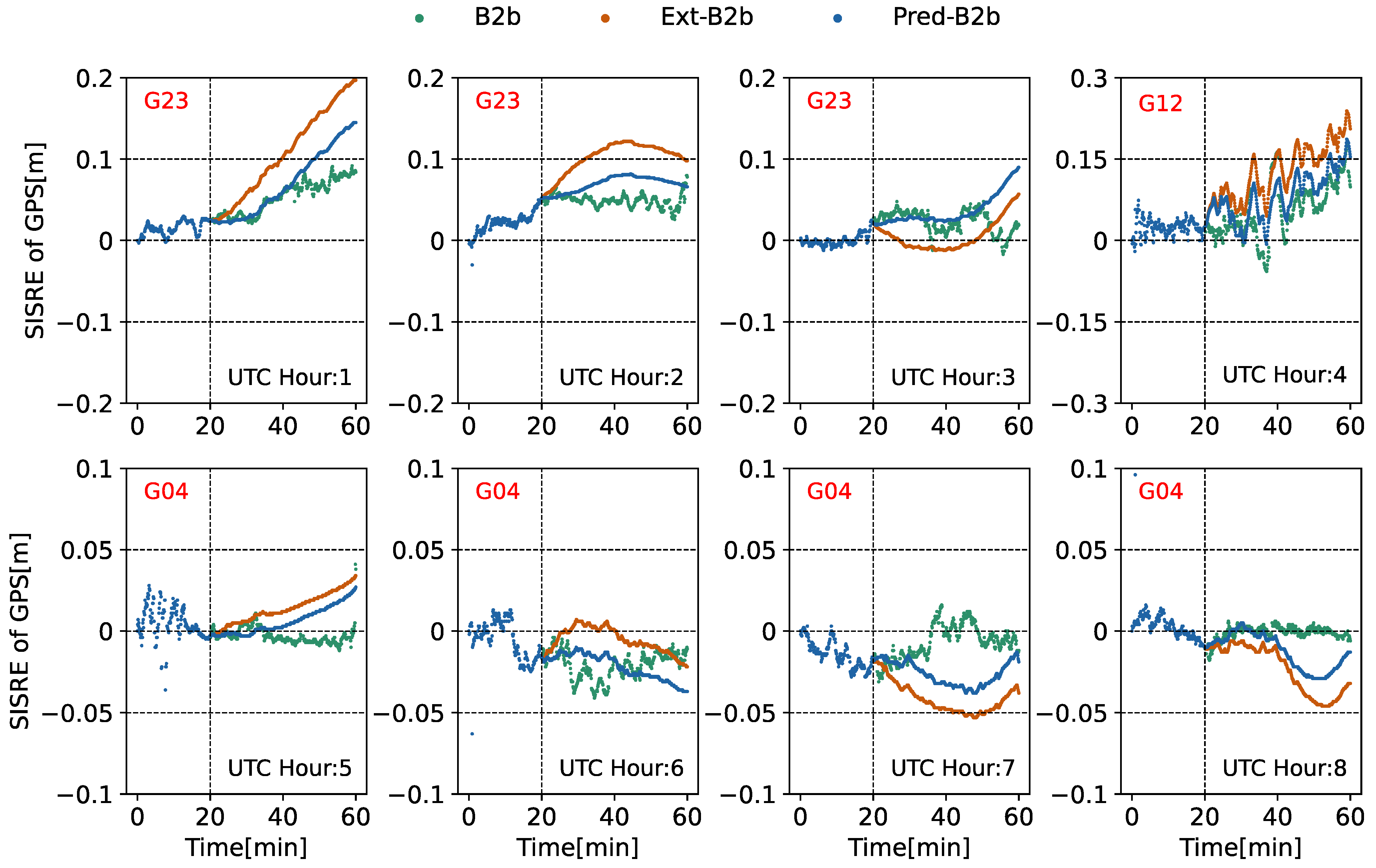
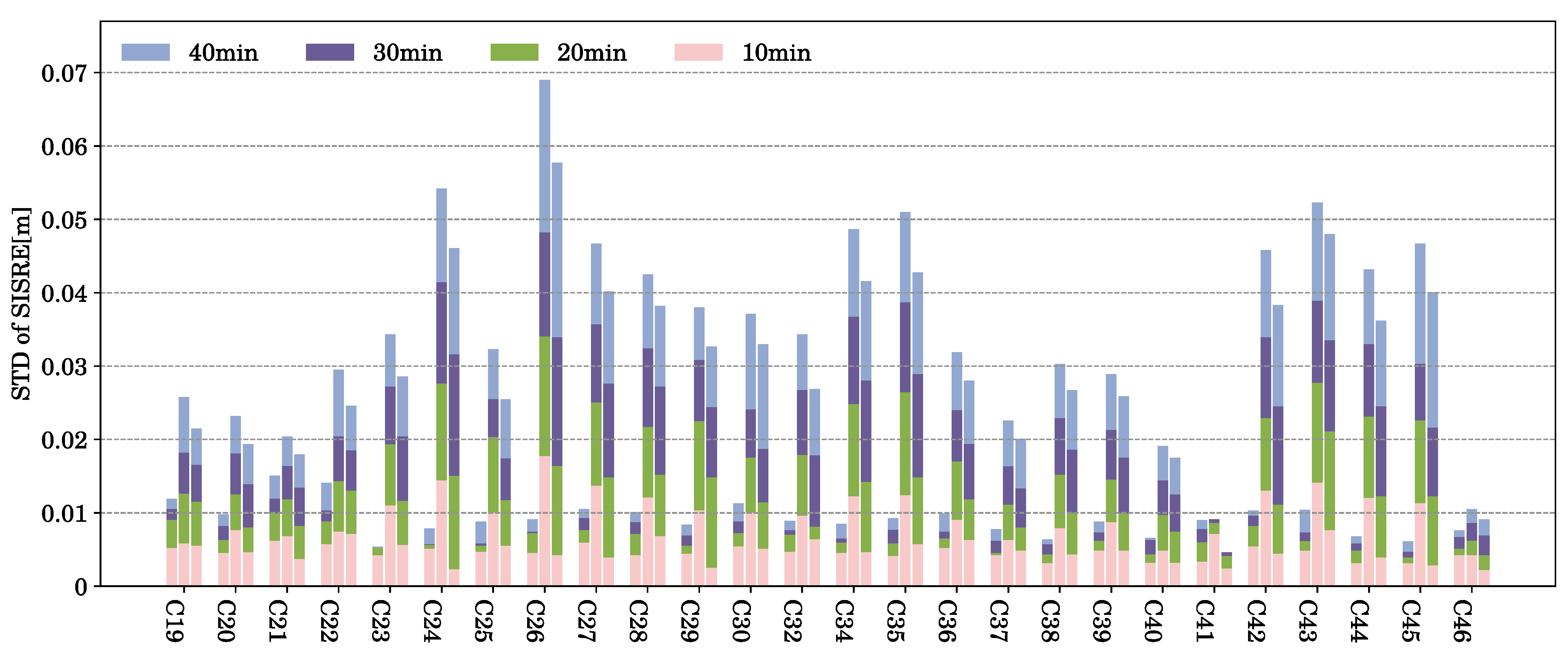
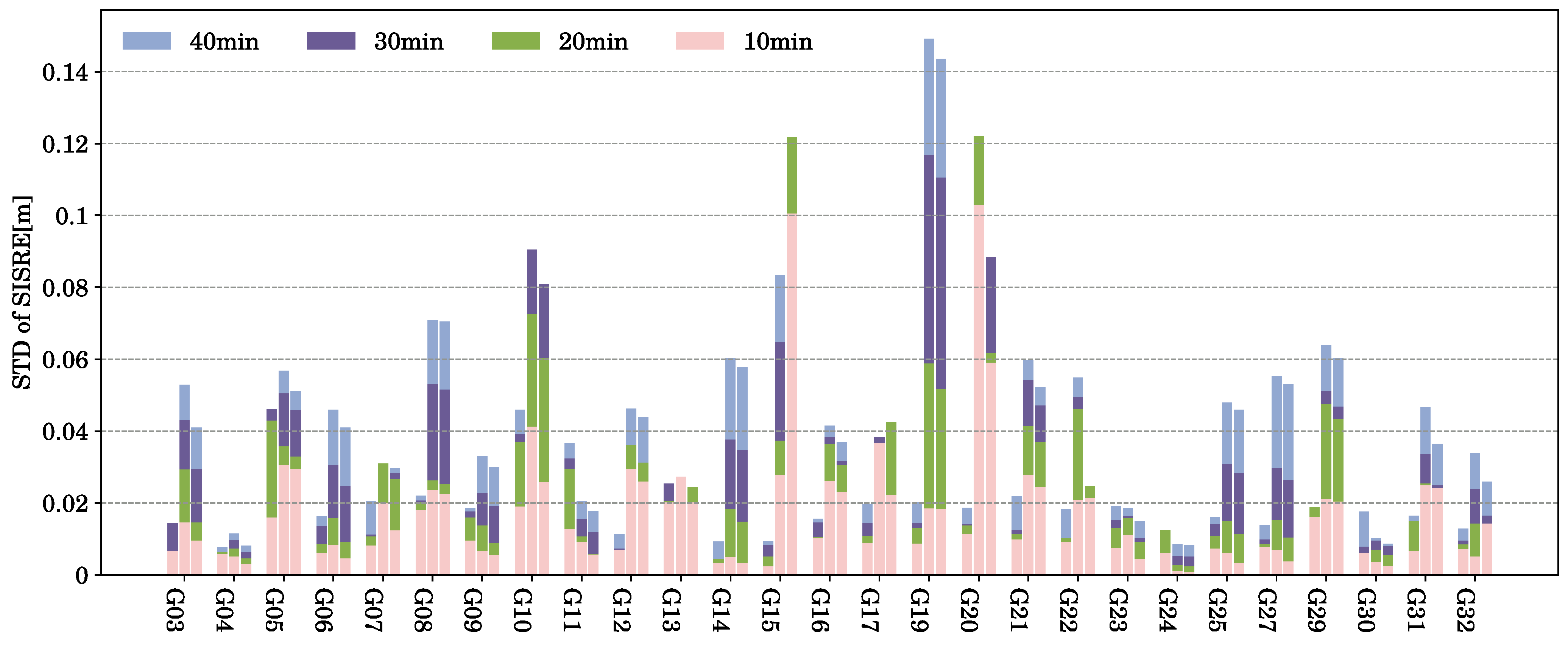
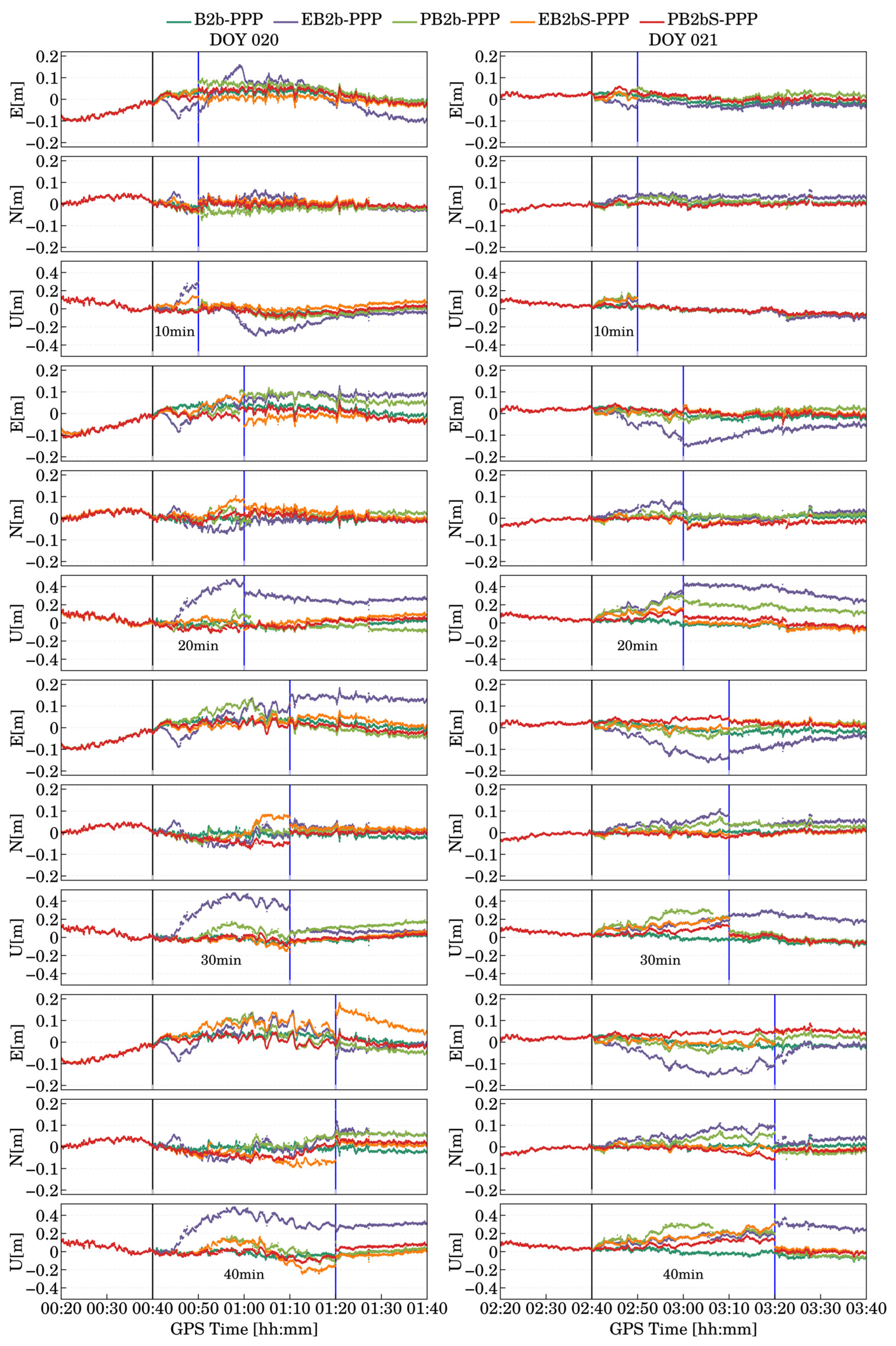
3. Analysis of SISRE Under Different Interruption Scenarios

To analyze the accuracy of SISREs, we placed a ComNav AT360 antenna, manufactured by ComNav Technology Ltd. (located in Shanghai, China), on the rooftop of the School of Transportation at Southeast University, as illustrated in Figure 1. A ComNav K823 receiver board, also manufactured by ComNav Technology Ltd., was utilized to receive B2b data in real time. Data collection was conducted using STRSVR software (version 2.4.3) from RTKLIB [34], while decoding was performed with PPPB2bMsgDecode (version 1.0) software provided by ComNav Technology Ltd. We collected three days of B2b data from DOY 340 to 342 in 2023, using the final orbit and clock products from Wuhan University (WHU) as our reference. In this analysis, we assessed the accuracy of two types of post-interruption products: the first type being model-predicted B2b (Pred-B2b) products and the second type which uses correction values from the last observation epoch before the interruption as the predicted product (Extended B2b, Ext-B2b).
Taking 8 h of data from GPS between the times 00:00 and 07:00 on DOY (Day of Year) 340 in 2023 as an example, we manually interrupted the B2b signal data at the 20th minute of each hour and then predicted the data for the subsequent time period (e.g., if the interruption occurred at 00:20, the data from 00:20 to 01:00 was Pred-B2b and Ext-B2b). Figure 2 and Figure 3 illustrate the SISRE of some of the BDS-3 and GPSs during each hour, comparing the continuous B2b arcs under normal conditions with those under Pred and Ext scenarios. As is evident from Figure 2, for BDS-3, the SISREs are generally less than 0.1 m. From 02:00 to 03:00, for C32, the Pred-B2b aligns well with B2b, whereas the Ext-B2b exhibits a noticeable deviation. For C20 and C39 from 06:00 to 08:00, although both Pred-B2b and Ext-B2b show deviations, Pred-B2b clearly demonstrates a better fit. Turning to Figure 3, the GPS exhibits similar characteristics; however, as shown in Hour 4, the SISRE of B2b, along with the SISRE of the Pred-B2b and Ext-B2b, exceeds 0.15 m. This is attributed to the relatively low accuracy of the B2b corrections in the GPS [30].
To further analyze the SISRE precision of the two prediction methods during signal interruptions, we processed hourly data over three days: the first twenty minutes of each hour received the B2b signal normally, followed by a prediction starting from the 20th minute. It is important to note that the generation of B2b products relies solely on reference stations in China and nearby regions, leading to a constant bias in the B2b clock corrections [30]. Consequently, we performed statistical analyses of the SISRE STD for the Ext and Pred prediction modes during interruption durations of 10, 20, 30, and 40 min (with B2b serving as a comparison without interruptions). Figure 4 and Figure 5 illustrate the STD of the SISRE for each satellite, presented as bar charts under different conditions.
From Figure 4, it is evident that, under uninterrupted conditions, BDS-3 maintains a relatively concentrated SISRE over the short term, despite a gradual increase in the STD of the SISRE with longer observation times, remaining at around 0.01 m. In the case of a 10 min interruption, the STD of B2b, Ext-B2b, and Preb-B2b is comparable. However, Ext-B2b shows a lower precision relative to the other two methods. As the interruption duration increases, both Ext-B2b and Pred-B2b exhibit a noticeable decline in precision. For instance, with a 40 min interruption for the C26 satellite, the STD of the SISRE of the Ext-B2b exceeds 0.06 m, while our Pred-B2b model demonstrates superior precision compared to Ext-B2b. In contrast, as shown in Figure 5, GPS shows inferior SISRE precision compared to BDS-3; under the 10 min interruption scenario, the STD of SISRE of the B2b model hovers at around 0.02 m. Nonetheless, the overall trend remains similar to that of BDS-3, where B2b offers the highest precision and Ext-B2b the lowest. Hence, for subsequent positioning tasks, the process noise of random walk assigned to individual satellites in Equation (12) can be adjusted based on their respective SISRE precision values. This approach facilitates the implementation of a positioning model that takes SISRE into account more effectively, ultimately enhancing the overall positioning performance.

4. Analysis of Positioning Results

To determine the impact of predicted orbits and clock corrections on positioning, we conducted positioning experiments by collecting both simulated and real kinematic data over several days at different time intervals. The PPP data processing strategy is outlined in Table 1. Using the standard B2b-PPP as a reference, we compared the positioning performance of several models under various interruption durations: Ext-B2b-based PPP (EB2b-PPP), Pred-B2b-based PPP (PB2b-PPP), Ext-B2b-based PPP with SISRE adjustment (EB2bS-PPP), and Pred-B2b-based PPP with SISRE adjustment (PB2bS-PPP). It is worth noting that, for positioning after the interruption of the B2b signal, the most crucial factors encompass not only the accuracy of positioning throughout the entire interruption period but also the maximum positioning error and the stability of positioning upon the resumption of B2b signal reception. Consequently, in the subsequent analysis of the positioning results, we will delve into these three aspects separately.

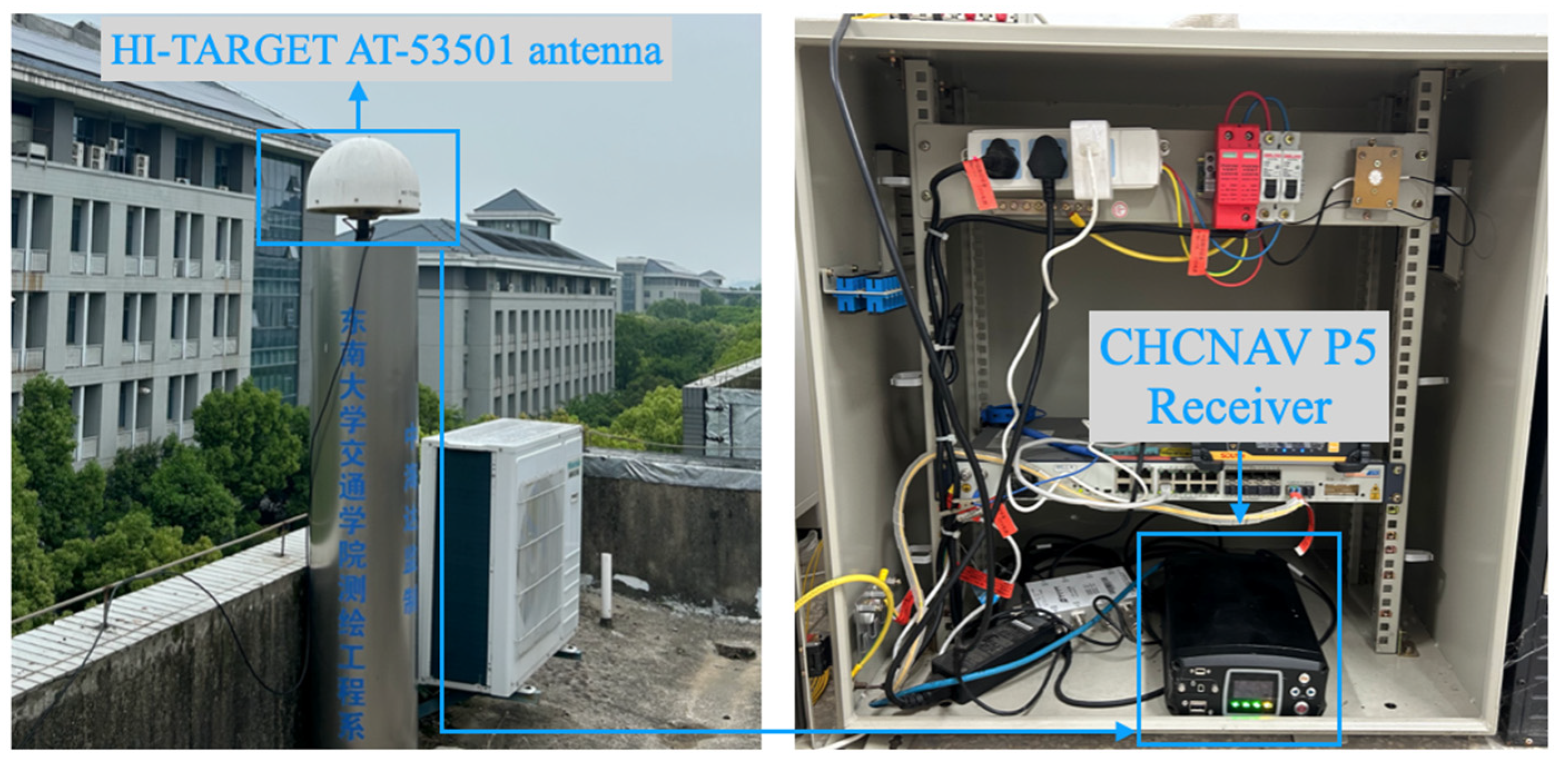
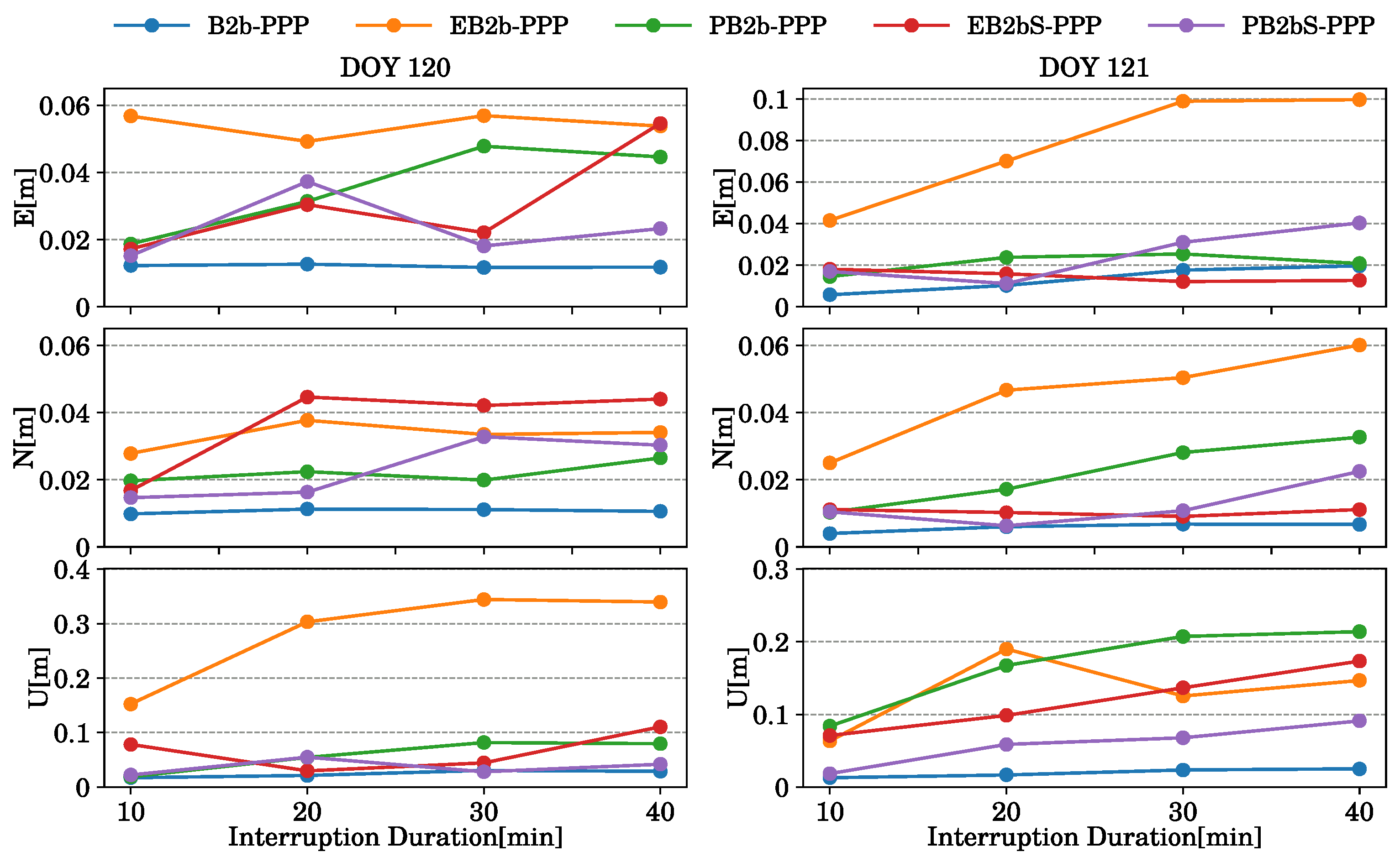
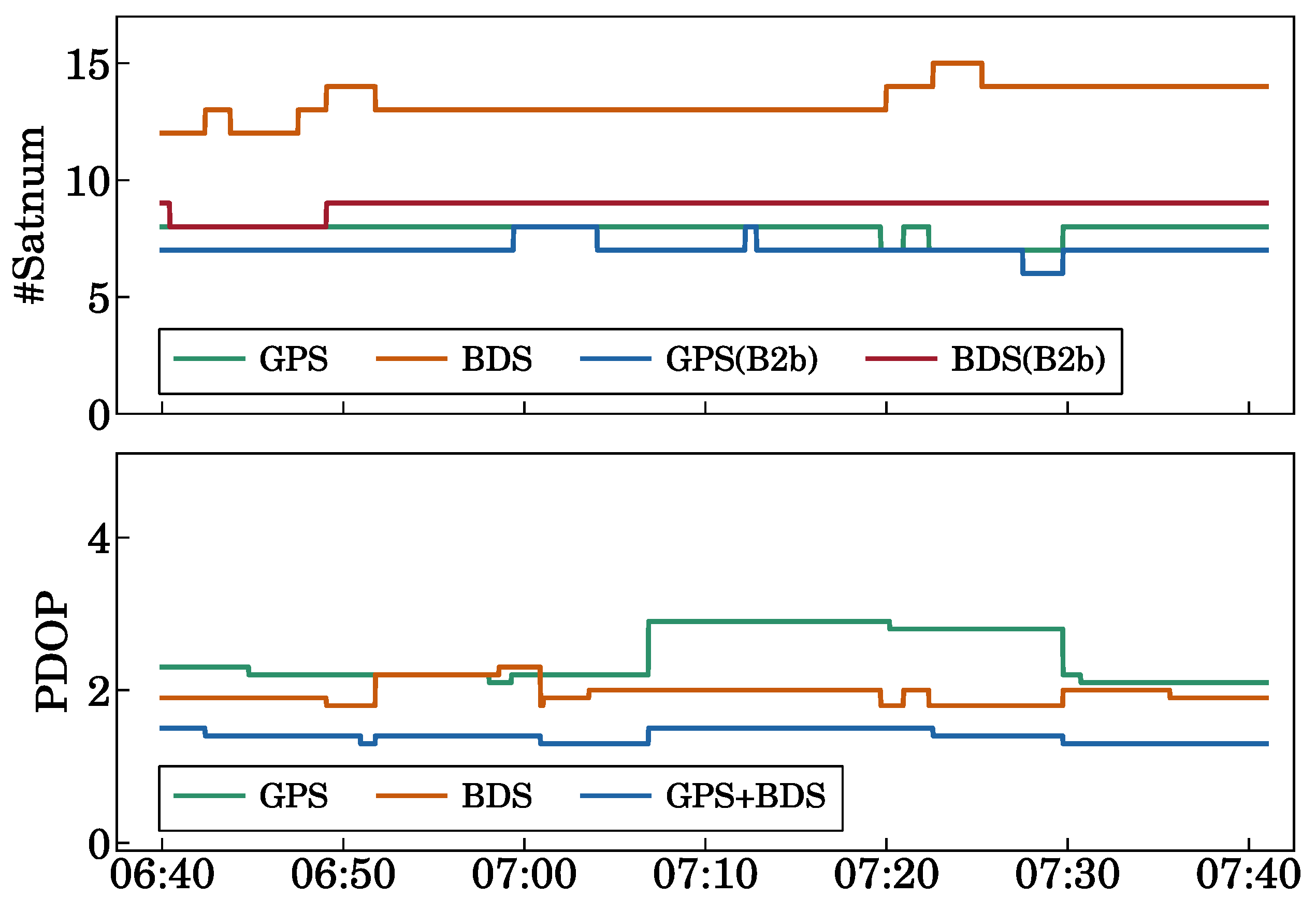
4.1. Analysis of Positioning Preformance Under a Simulated Kinematic Experiment with Different Interruption Durations

The simulated kinematic data collection setup, as depicted in Figure 6, was implemented at the RTK (real time kinematic) base station (ZHD0) situated within the Jiulonghu campus of Southeast University. On DOY 120–121 in 2024, data were gathered from this station, which is furnished with a precision HI-TARGET AT-53501 antenna and a CHCNAV P5 receiver. To conduct a differentiated comparison that considers the characteristics of BRDC interruptions at the hour mark, we selected experimental data from 00:20 to 01:40 on DOY 120, and from 02:20 to 03:40 on DOY 121.
The observable number of satellites for the two data segments is shown in Figure 7. It can be observed that, except for the period from 1:15 to 1:37 on DOY 120, when the number of GPS satellites was relatively low, the number of satellites in the two segments was similar at other times. It is also evident that BDS has a higher number of observable satellites. However, since B2b only broadcasts corrections for BDS-3 satellites, the number of matched BDS-3 satellites is close to the observable number of GPS satellites. In comparison, after fusing GPS and BDS-3, the PDOP (position dilution of precision) can be maintained below 2. Therefore, in this test, we utilized the combined positioning results from BDS-3 and GPS.
On DOY 120, we initiated positioning at 0:20 and artificially interrupted the B2b data transmission at 0:40. For DOY 121, positioning commenced at 2:20, followed by an interruption in the B2b data transmission at 2:40. To validate the positioning accuracy under varying interruption durations, we conducted positioning tests with interruptions of 10 min, 20 min, 30 min, and 40 min for both sets of data. The root mean square (RMS) results of positioning in the E/N/U directions during the B2b signal interruption for DOY 120 and DOY 121 are presented in Table 2 and Table 3 (for the sake of esthetic appeal, in the tables, we have set the unit of RMS to centimeters). Notably, B2b-PPP serves as the benchmark, representing the scenario where the B2b signal remains uninterrupted.
For DOY 120, it is evident that the EB2b-PPP method performs the worst, with positioning errors exceeding 0.025 m in the E/N directions and over 0.1 m in the U direction even with just a 10 min interruption in the B2b signal. From the results of EB2bS-PPP, it becomes clear that incorporating the SISRE significantly improves the positioning accuracy. This demonstrates the effectiveness of utilizing SISRE techniques to mitigate the impact of signal interruptions. Furthermore, our B2b signal prediction method shows a notable improvement for this dataset. The PB2b-PPP accuracy is comparable to that of EB2bS-PPP, indicating that the predicted B2b signals can effectively substitute for actual measurements during interruptions. Furthermore, PB2bS-PPP emerges as the best-performing method, achieving a positioning accuracy comparable to B2b-PPP even when the B2b signal is interrupted for 40 min. This highlights the combined benefits of B2b corrections prediction and SISRE enhancements in maintaining high positioning accuracy under challenging conditions.
For DOY 121, it can be observed that EB2b-PPP demonstrates a relatively good positioning performance within this dataset. However, as shown in Table 3, under various interruption conditions, PB2bS-PPP outperforms the other positioning methods. Overall, EB2b-PPP exhibits the lowest positioning accuracy among the models compared. EB2bS-PPP, which incorporates enhancement techniques, slightly surpasses PB2b-PPP in positioning precision. When focusing on horizontal accuracy (E and N directions), EB2bS-PPP and PB2bS-PPP show similar performances. In contrast, for vertical accuracy (U), PB2bS-PPP clearly stands out as the most accurate model.
It is worth noting that both Table 2 and Table 3 show cases where longer interruptions result in a better positioning accuracy than shorter interruptions. For example, in Table 2, for EB2bS-PPP, the positioning accuracy in the U direction with a 20 min interruption is better than that with a 10 min interruption. In Table 3, for PB2bS-PPP, the positioning accuracy in both the E and N directions is superior with a 30 min interruption compared to a 10 min interruption. This is because, in practical positioning, B2b corrections do not change monotonically over time. Therefore, the positioning results do not necessarily increase or decrease monotonically with the predicted corrections, leading to the phenomenon where longer interruptions result in better positioning accuracy than shorter ones.
To further illustrate this, we have plotted the positioning errors in the E/N/U directions for five positioning models across different interruption durations in Figure 8. In Figure 8, the black vertical lines represent the moments when B2b signal interruption began, while the blue vertical lines indicate the resumption of B2b signal reception. From Figure 8, we can clearly observe the positioning fluctuations, and draw conclusions like those in Table 2 and Table 3, namely that PB2bS-PPP aligns most favorably with B2b-PPP. Furthermore, from Figure 8, we can see that the maximum positioning error is one of the key indicators for evaluating positioning performance during B2b signal interruptions. Therefore, Figure 9 showcases the maximum positioning errors in the E/N/U directions across four distinct time intervals.
Figure 9 reveals that, in terms of horizontal positioning accuracy, PB2bS-PPP exhibits maximum positioning errors below 0.04 m, while PB2b-PPP and EB2bS-PPP both maintain maximum errors below 0.06 m. In contrast, EB2b-PPP’s maximum positioning deviation surpasses 0.1 m. Regarding the vertical dimension, EB2b-PPP, EB2bS-PPP, and PB2b-PPP record maximum positioning deviations exceeding 0.1 m. Notably, EB2b-PPP stands out with deviations that even exceed 0.3 m, underscoring its significant shortcoming in this regard. Conversely, PB2bS-PPP demonstrates a more contained deviation, with all values falling below 0.1 m, highlighting its relative superiority in vertical positioning.
From Figure 8, we can also gain further insights into the positioning stability of various models following the restoration of B2b signals. For the four prediction models applied to the two sets of data, positioning remains relatively stable both before and immediately after the 10 min interruption of B2b signals. However, as the duration of the interruption increases, EB2b-PPP struggles to converge to a positioning accuracy comparable to that of B2b-PPP upon signal restoration. Additionally, EB2bS-PPP and PB2b-PPP also exhibit instances of non-convergence, such as in the case of EB2bS-PPP for the E direction on DOY 120 after a 40 min interruption, and PB2b-PPP for the U direction on DOY 121 after a 20 min interruption, with both failing to achieve satisfactory results. In contrast, PB2bS-PPP consistently demonstrates satisfactory stability before and after signal restoration, underscoring its importance for practical dynamic positioning applications. This robustness is clearly crucial for ensuring reliable and accurate positioning in dynamic environments.

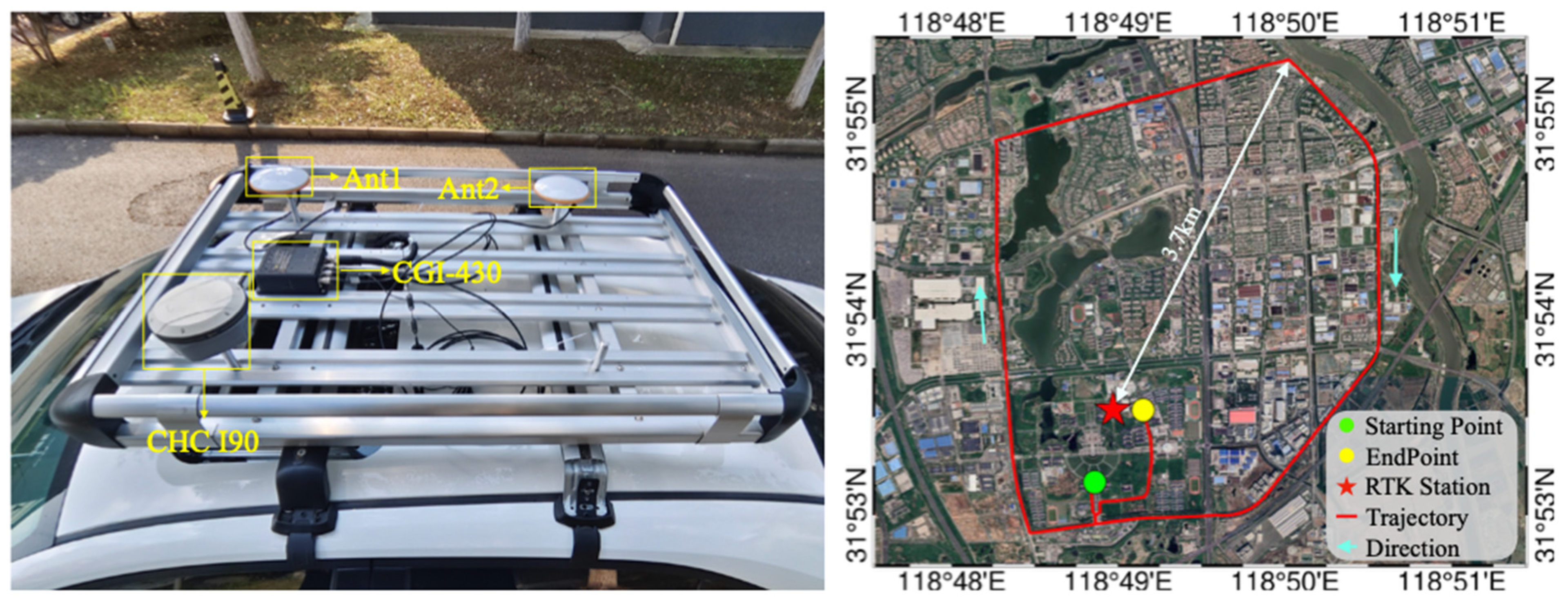
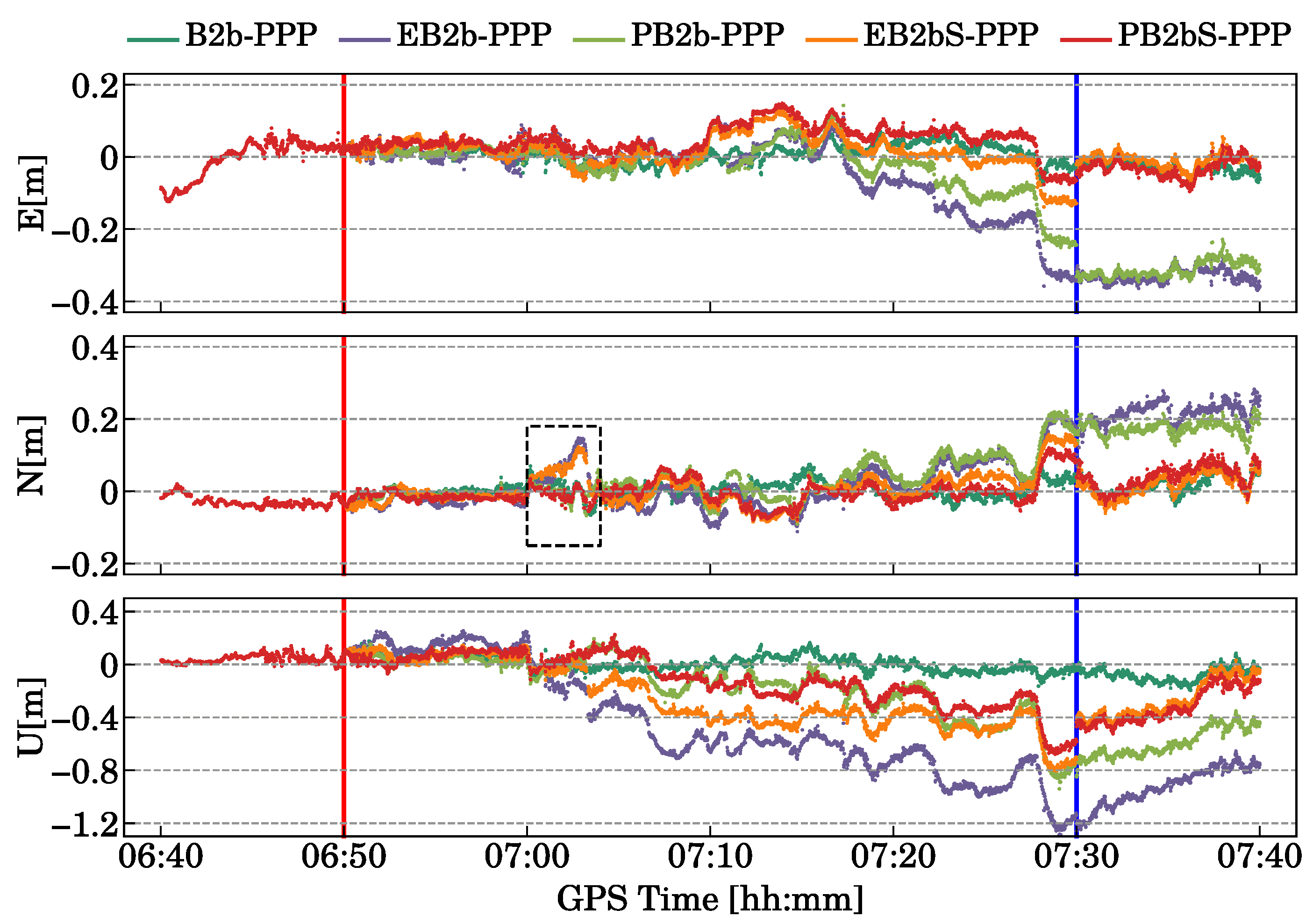
4.2. Analysis of Positioning Performance Under Kinematic Experiment with Different Interruption Durations

To demonstrate the kinematic positioning accuracy of B2b-PPP prediction and positioning model under B2b signal interruption conditions, we conducted practical kinematic positioning tests in Nanjing on DOY 177, 2024. As illustrated in the left panel of Figure 10, a CHCNAV I90 receiver was mounted on the roof of a vehicle to capture kinematic BDS-3 and GPS observation data during the test. The CGI-430 GNSS/INS integrated navigation device from CHCNAV served as the benchmark for kinematic positioning, and the base station ZHD0 in Figure 6 provided the RTK reference for CGI-430. Concurrently, we employed the board depicted in Figure 2 to receive B2b corrections in real-time for B2b-PPP. As evidenced by the test trajectory in Figure 10 (right), there were no GNSS interruptions recorded throughout our entire test route, and the maximum linear distance between the test route and the ZHD0 station was 3.7 km. Under such circumstances, the nominal accuracy of the CGI-430 can achieve 0.02 m in the horizontal and 0.03 m in the vertical direction, providing a precise and genuine positioning accuracy reference for evaluating our B2b-PPP approach. Notably, when outputting the dynamic positioning results from the CGI-430, we conducted lever arm corrections to align the positioning outcomes with those from the I90 receiver.
The entire positioning test lasted for 60 min, spanning from GPS time 06:40 to 07:40. Figure 11 presents the number of satellites received during dynamic testing, the number of satellites matched in B2b, and the corresponding PDOP values. During the period from 6:40 to 6:50, we utilized B2b corrections for normal positioning. Starting from 6:50, we artificially interrupted the B2b signals and conducted a comparative analysis of positioning accuracy among the four proposed positioning models under B2b signal interruption scenarios. The statistical results of positioning accuracy for interruptions lasting 10 min, 20 min, 30 min, and 40 min are presented in Table 4. Furthermore, to provide a more intuitive comparison of the positioning performance of the four models, Figure 12 showcases the positioning accuracy of the five models under a 40 min interruption scenario, as well as the convergence situation after B2b signal restoration at 7:30. This visualization enables a clear assessment of how each model copes with extended signal outages and their subsequent recovery capabilities.
As is evident from Table 4, under uninterrupted B2b signal conditions and in dynamic scenarios, the positioning accuracy of B2b-PPP in the E/N direction is approximately 0.04 m to 0.06 m, while in the U direction, it remains around 0.15 m. Similar to simulated dynamic positioning, EB2b-PPP exhibits the poorest positioning performance, with a U-direction positioning RMS of up to 0.269 m after just 10 min of interruption. Although PB2bS-PPP also experiences an increase in positioning error with longer interruption durations, it maintains a positioning RMS below 0.1 m in the E/N direction even after 40 min. Compared to the two direct prediction models mentioned earlier, EB2bS-PPP and PB2bS-PPP show a similar positioning accuracy in the horizontal direction, but PB2bS-PPP outperforms in the U direction, with an RMS below 0.2 m.
Additionally, Figure 12 shows that when interruptions last for 40 min, the maximum positioning errors in the two SISRE-corrected models are significantly lower than those of models that do not account for SISRE. Specifically, PB2bS-PPP has a maximum E/N positioning error of less than 0.1 m, and in the U direction, it maintains a maximum error of less than 0.4 m for interruptions not exceeding 37 min. Following signal restoration, both EB2bS-PPP and PB2bS-PPP converge more rapidly or align directly with the uninterrupted B2b signal scenario, highlighting the improvement in predicting B2b corrections when SISRE is considered. Notably, as indicated by the black boxes in Figure 12, directly using B2b extension results can lead to abnormal and sudden changes in positioning. Therefore, in actual B2b signal interruption scenarios, we recommend utilizing PB2bS-PPP to ensure high-precision positioning over extended periods.

5. Conclusions

Due to the “south wall effect”, signal matching priority, and IOD matching errors, B2b signals in dynamic positioning are susceptible to obstruction by buildings, mountains, and other structures, resulting in positioning interruptions. Existing B2b signal prediction models inevitably suffer from discrepancies between the predicted and actual signals. As the prediction time increases, positioning accuracy declines rapidly, and when the B2b signal is restored, positioning jumps can occur due to the deviation between the predicted and real signals. In this paper, we introduce SISRE parameters to absorb residual errors from the predicted signals, and develop observation and stochastic models that incorporate SISRE, aiming to achieve continuous, seamless, high-precision positioning based on B2b.
First, we analyzed the SISRE of three B2b products, B2b, Ext-B2b, and Pred-B2b, during interruptions of 10, 20, 30, and 40 min. The results revealed that the B2b SISRE for BDS-3 generally remains below 0.1 m, while the SISRE for GPS occasionally exceeds 0.15 m. Additionally, the Pred-B2b showed better alignment with the actual B2b signal during signal interruptions. Furthermore, a three-day statistical analysis indicated that the STD of the B2b SISRE for BDS-3 is primarily below 0.01 m, whereas for GPS, it is mostly under 0.02 m. As the interruption duration increases, the SISRE for both Ext-B2b and Pred-B2b gradually declines, with Pred exhibiting superior performance metrics.
Simulated dynamic positioning experiments revealed that the EB2b-PPP performance is the weakest, with positioning errors in the U direction exceeding 0.1 m during a 10 min interruption. In contrast, the performances of EB2bS-PPP and PB2b-PPP are comparable, though the PB2bS-PPP model demonstrated the best overall positioning performance. After a 40 min interruption, the positioning RMS of PB2bS-PPP in the E/N/U directions remained below 0.05 m, with the maximum positioning deviation not exceeding 0.1 m. Furthermore, upon re-acquisition of the B2b signal, the PB2bS-PPP model exhibited a smooth transition in positioning.
Although the positioning accuracy of the real dynamic positioning experiments is lower than that of the simulated dynamic positioning experiments, their performance results are similar. During a 40 min interruption, the PB2bS-PPP model exhibited an RMS in the E/N directions of less than 0.1 m, with a maximum positioning deviation also under 0.1 m. The RMS in the U direction is also below 0.2 m, and the maximum positioning deviation is better than 0.4 m within a 37 min interruption. Furthermore, upon restoration of the B2b signal, stable positioning was maintained. Therefore, the PB2bS-PPP model proposed in this paper effectively ensures continuous and stable positioning based on B2b signals.

Author Contributions

Conceptualization, R.S. and Z.X.; methodology, R.S.; software, Z.X. validation, Q.L.; formal analysis, R.S.; investigation, R.S. and Z.X.; resources, R.S. and W.G.; data curation, Z.X. and R.S.; writing—original draft preparation, R.S; writing—review and editing, C.G., R.S., X.M. and W.G.; visualization, Z.X., R.S. and Q.L.; supervision, C.G. and X.M.; project administration R.S.; funding acquisition R.S. All authors have read and agreed to the published version of the manuscript.

Funding

This work was supported by the National Natural Science Foundation of China (No. 42404024) and Jiangsu Funding Program for Excellent Postdoctoral Talent (No. 2022ZB113).

Data Availability Statement

The data that support the findings of this study are available on request from the corresponding author, upon reasonable request.

Acknowledgments

The authors gratefully acknowledge the valuable comments from the anonymous reviewers.

Conflicts of Interest

The authors declare no conflicts of interest.

References

  1. Malys, S.; Jensen, P.A. Geodetic point positioning with GPS carrier beat phase data from the CASA UNO experiment. Geophys. Res. Lett. 1990, 17, 651–654. [Google Scholar] [CrossRef]
  2. Zumberge, J.; Heflin, M.; Jefferson, D.; Watkins, M.; Webb, F.H. Precise point positioning for the efficient and robust analysis of GPS data from large networks. J. Geophys. Res. Solid. Earth 1997, 102, 50055017. [Google Scholar] [CrossRef]
  3. An, X.; Meng, X.; Jiang, W. Multi-constellation GNSS precise point positioning with multi-frequency raw observations and dual-frequency observations of ionospheric-free linear combination. Satell. Navig. 2020, 1, 7. [Google Scholar] [CrossRef]
  4. Zhao, Q.; Pan, S.; Gao, C.; Gao, W.; Xia, Y. BDS/GPS/LEO triple-frequency uncombined precise point positioning and its performance in harsh environments. Measurement 2020, 151, 107216. [Google Scholar] [CrossRef]
  5. Xiao, P.; Sun, F.; Wang, K.; Xiao, K.; Shang, X.; Liu, J. Positioning performance analysis of real-time BDS-3 PPP-B2b/INS tightly coupled integration in urban environments. Adv. Space Res. 2023, 72, 4008–4020. [Google Scholar] [CrossRef]
  6. Shang, R.; Gao, C.; Meng, X.; Xu, Z.; Liu, Q.; Chen, Q.; An, X. Lightweight seamless lane-level positioning with the integration of BDS-3 PPP-B2b and VINS: A case study using smartphone. GPS Solut. 2024, 28, 185. [Google Scholar] [CrossRef]
  7. CSNO. BeiDou Navigation Satellite System Signal in Space Interface Control Document Precise Point Positioning Service Signal PPP-B2b (Version 1.0). 2020. Available online: http://www.beidou.gov.cn/xt/gfxz/202008/P020200803362062482940.pdf (accessed on 5 January 2025).
  8. Liu, Y.; Yang, C.; Zhang, M. Comprehensive Analyses of PPP-B2b Performance in China and Surrounding Areas. Remote Sens. 2022, 14, 643. [Google Scholar] [CrossRef]
  9. Lu, X.; Chen, L.; Shen, N.; Wang, L.; Jiao, Z.; Chen, R. Decoding PPP corrections from BDS B2b signals using a software-defined receiver: An initial performance evaluation. IEEE Sens. J. 2020, 21, 7871–7883. [Google Scholar] [CrossRef]
  10. Zhang, W.; Lou, Y.; Song, W.; Sun, W.; Zou, X.; Gong, X. Initial assessment of BDS-3 precise point positioning service on GEO B2b signal. Adv.Space Res. 2022, 69, 690–700. [Google Scholar] [CrossRef]
  11. Zhou, H.; Wang, L.; Fu, W.; Han, Y.; Li, T.; Li, W.; Chen, R. Real-time single-frequency precise point positioning using BDS-3 PPP-B2b corrections. Measurement 2022, 205, 112178. [Google Scholar] [CrossRef]
  12. Ge, Y.; Cao, X.; Lyu, D.; He, Z.; Xiao, G.; Shen, F. An investigation of PPP time transfer via BDS-3 PPP-B2b service. GPS Solut. 2023, 27, 61. [Google Scholar] [CrossRef]
  13. Ren, Z.; Gong, H.; Peng, J.; Tang, C.; Huang, X.; Sun, G. Performance assessment of real-time precise point positioning using BDS PPP-B2b service signal. Adv. Space Res. 2021, 68, 3242–3254. [Google Scholar] [CrossRef]
  14. Wu, P.; Lou, Y.; Zhang, W.; Jan, D.; He, H.; Chai, J.; Ouyang, Y.; Zhang, Z.; Zou, X. Evaluation of real-time kinematic positioning performance of the BDS-3 PPP service on B2b signal. GPS Solut. 2023, 27, 192. [Google Scholar] [CrossRef]
  15. Xu, Y.; Yang, Y.; Li, J. Performance evaluation of BDS-3 PPP-B2b precise point positioning service. GPS Solut. 2021, 25, 142. [Google Scholar] [CrossRef]
  16. European Union. Galileo High Accuracy Service Signal-InSpace Interface Control Document (HAS SIS ICD) Issue 1.0. 2022. Available online: https://www.gsc-europa.eu/sites/default/files/sites/all/files/Galileo_HAS_SIS_ICD_v1.0.pdf (accessed on 5 January 2025).
  17. European Union. Galileo High Accuracy Service Service Definition Document (HAS SDD) Issue 1.0. 2023. Available online: https://www.gsc-europa.eu/sites/default/files/sites/all/files/Galileo-HAS-SDD_v1.0.pdf (accessed on 5 January 2025).
  18. Yang, Y.; Liu, L.; Li, J.; Yang, Y.; Zhang, T.; Mao, Y.; Sun, B.; Ren, X. Featured Services and Performance of BDS-3. Sci. Bull. 2021, 66, 2135–2143. [Google Scholar] [CrossRef]
  19. Yang, Y.; Ding, Q.; Gao, W.; Li, J.; Xu, Y.; Sun, B. Principle and performance of BDSBAS and PPP-B2b of BDS-3. Satell. Navig. 2022, 3, 5. [Google Scholar] [CrossRef]
  20. Yang, Y.; Mao, Y.; Sun, B. Basic performance and future developments of BeiDou global navigation satellite system. Satell. Navig. 2020, 1, 1. [Google Scholar] [CrossRef]
  21. Tao, J.; Liu, J.; Hu, Z.; Zhao, Q.; Chen, G.; Ju, B. Initial Assessment of the BDS-3 PPP-B2b RTS compared with the CNES RTS. GPS Solut. 2021, 25, 131. [Google Scholar] [CrossRef]
  22. Xu, X.; Nie, Z.; Wang, Z.; Zhang, Y.; Dong, L. An Improved BDS-3 PPP-B2b Positioning Approach by Estimating Signal in Space Range Errors. GPS Solut. 2023, 27, 110. [Google Scholar] [CrossRef]
  23. Xu, Z.; Shang, R.; Gao, C.; Gao, W.; Liu, Q.; Long, F.; Xu, D. Temporal Characteristics Based Outlier Detection and Prediction Methods for PPP-B2b Orbit and Clock Corrections. Remote Sens. 2024, 16, 2337. [Google Scholar] [CrossRef]
  24. Ge, H.; Meng, G.; Li, B. Zero-reconvergence PPP for real-time low-earth satellite orbit determination in case of data interruption. IEEE J. Sel. Top. Appl. Earth Obs. Remote Sens. 2024, 17, 4705–4715. [Google Scholar] [CrossRef]
  25. Chen, Y.; Wang, X.; Zhou, K.; Zhang, J.; Qiu, C.; Li, H.; Xin, S. Real-Time Precise Point Positioning during Outages of the PPP-B2b Service. Remote Sens. 2023, 15, 784. [Google Scholar] [CrossRef]
  26. Montenbruck, O.; Steigenberger, P.; Hauschild, A. Multi-GNSS signal-in-space range error assessment—Methodology and results. Adv. Space Res. 2018, 61, 3020–3038. [Google Scholar] [CrossRef]
  27. Carlin, L.; Hauschild, A.; Montenbruck, O. Precise point positioning with GPS and Galileo broadcast ephemerides. GPS Solut. 2021, 25, 77. [Google Scholar] [CrossRef]
  28. Chen, G.; Wei, N.; Li, M.; Zhao, Q.; Zhang, J. BDS-3 and GPS/Galileo integrated PPP using broadcast ephemerides. GPS Solut. 2022, 26, 129. [Google Scholar] [CrossRef]
  29. Tang, C.; Hu, X.; Chen, J.; Liu, L.; Zhou, S.; Guo, R.; Li, X.; He, F.; Liu, J.; Yang, J. Orbit determination, clock estimation and performance evaluation of BDS-3 PPP-B2b service. J. Geod. 2022, 96, 60. [Google Scholar] [CrossRef]
  30. Sun, S.; Wang, M.; Liu, C.; Meng, X.; Ji, R. Long-term performance analysis of BDS-3 precise point positioning (PPP-B2b) service. GPS Solut. 2023, 27, 69. [Google Scholar] [CrossRef]
  31. Yao, Y.; He, Y.; Yi, W.; Song, W.; Cao, C.; Chen, M. Method for evaluating real-time GNSS satellite clock offset products. GPS Solut. 2017, 21, 1417–1425. [Google Scholar] [CrossRef]
  32. Lou, Y.; Zheng, F.; Gu, S.; Wang, C.; Guo, H.; Feng, Y. Multi-GNSS precise point positioning with raw single-frequency and dual-frequency measurement models. GPS Solut. 2016, 20, 849–862. [Google Scholar] [CrossRef]
  33. Zhou, F.; Dong, D.; Li, P.; Li, X.; Schuh, H. Influence of stochastic modeling for inter-system biases on multi-GNSS undifferenced and uncombined precise point positioning. GPS Solut. 2019, 23, 59. [Google Scholar] [CrossRef]
  34. Takasu, T.; Yasuda, A. Development of the low-cost RTK-GPS receiver with an open source program package RTKLIB. In Proceedings of the International Symposium on GPS/GNSS. International Convention Center, Jeju, Republic of Korea, 12–17 July 2009; Volume 1. Available online: https://gpspp.sakura.ne.jp/paper2005/isgps_2009_rklib.pdf (accessed on 5 January 2025).
  35. Saastamoinen, J. Atmospheric correction for the troposphere and stratosphere in radio ranging satellites. The use of artificial satellites for geodesy, American Geophysics Union. Geophys. Monogr. Ser. 1972, 15, 247–251. [Google Scholar] [CrossRef]
  36. Böhm, J.; Niell, A.; Tregoning, P.; Schuh, H. Global Mapping Function (GMF): A new empirical mapping function based on numerical weather model data. Geophys. Res. Lett. 2006, 33, L07304. [Google Scholar] [CrossRef]
  37. Rebischung, P.; Schmid, R. IGS14/igs14.atx: A new framework for the IGS products. In Proceedings of the AGU Fall Meeting, San Francisco, CA, USA, 12–16 December 2016. [Google Scholar]
  38. Kouba, J. A Guide to Using International GNSS Service (IGS) Products. 2009. Available online: https://files.igs.org/pub/resource/pubs/UsingIGSProductsVer21_cor.pdf (accessed on 5 February 2025).
Figure 1. B2b data collection experimental setup. The left panel is the antenna we used, while the right panel displays the ComNav K823 receiver board.
Remotesensing 17 00618 g001
Figure 2. SISRE of BDS-3 for different interruption scenarios (spanning from 10 min to 40 min).
Remotesensing 17 00618 g002
Figure 3. SISRE of GPS for different interruption scenarios (spanning from 10 min to 40 min).
Remotesensing 17 00618 g003
Figure 4. STD of SISRE for BDS-3 satellites under different interruption durations in non-Interrupted, Ext, and Pred Scenarios (Each label contains three bars representing the three methods: the first column represents B2b, the second column represents the Ext-B2b, and the third column represents the Pred-B2b).
Remotesensing 17 00618 g004
Figure 5. STD of SISRE for GPS satellites under different interruption durations in non-Interrupted, Ext, and Pred Scenarios (Each label contains three bars representing the three methods: the first column represents B2b, the second column represents the Ext-B2b, and the third column represents the Pred-B2b).
Remotesensing 17 00618 g005
Figure 6. The ZHD0 station used for collecting static experiment data. The left panel displays the antenna used, while the right panel shows the receiver.
Remotesensing 17 00618 g006
Figure 7. The effective satellites and PDOP for the ZHD0 on DOY 120 (left) and 121 (right).
Remotesensing 17 00618 g007
Figure 8. The positioning errors in the E/N/U directions for the B2b-PPP, EB2b-PPP, PB2b-PPP, EB2bS-PPP, and PB2bS-PPP under signal interruptions of 10 min, 20 min, 30 min, and 40 min on DOY 120 and 121.
Remotesensing 17 00618 g008
Figure 9. The maximum positioning errors in the E/N/U directions for the B2b-PPP, EB2b-PPP, PB2b-PPP, EB2bS-PPP, and PB2bS-PPP under signal interruptions of 10 min, 20 min, 30 min, and 40 min on DOY 120 and 121.
Remotesensing 17 00618 g009
Figure 10. Dynamic vehicle-mounted positioning experimental setup (left) and trajectory of the measurement campaign (right).
Remotesensing 17 00618 g010
Figure 11. The number of effective satellites and PDOP for the kinematic experiment.
Remotesensing 17 00618 g011
Figure 12. Positioning errors in the E/N/U directions for various PPP models (B2b-PPP, EB2b-PPP, PB2b-PPP, EB2bS-PPP, and PB2bS-PPP) during a 40 min B2b signal interruption in the kinematic experiment.
Remotesensing 17 00618 g012
Table 1. Summary of the PPP processing strategy.
ItemProcessing Strategies
ObservationsDual frequency pseudo-range and carrier phase IF combinations
GNSS SignalsGPS (L1, L2), BDS-3 (B1I, B3I)
Satellite orbits and clock(1) CNAV1, LNAV + B2b (B2b-PPP)
(2) CNAV1, LNAV + Ext-B2b (EB2b-PPP)
(3) CNAV1, LNAV + Pred-B2b (PB2b-PPP)
(4) CNAV1, LNAV + Ext-B2b + SISRE (EB2bS-PPP)
(5) CNAV1, LNAV + Pred-B2b + SISRE (PB2bS-PPP)
DCBThe DCB products from B2b [7]
SISREEstimated as random walk
Cutoff elevation10°
Ambiguitiesfloat
Atmospheric delaysZHD is corrected by the Saastamoinen model [35] and mapping function is from GMF [36]
Satellite PCO/PCVigs14.atx [37]
Relativistic effectModel corrected [38]
Phase windupModel corrected [38]
Tide modelSolid tide and Ocean tide model corrected [38]
Receiver clockEstimated as white noise, and the GPS and BDS-3 measurements are processed distinctively
Receiver positionWhite noise
EstimationKalman filter
Table 2. Comparison of positioning accuracy among four prediction models under different interruption durations for DOY 120 (where B2b-PPP represents an uninterrupted B2b signal).
PPP ModelRMS of E/N/U Position Errors (cm)
10 min20 min30 min40 min
ENUENUENUENU
B2b-ppp1.211.71.311.91.212.81.212.7
EB2b-ppp2.52.710.74.53.417.55.63.215.75.23.413.7
PB2b-ppp1.71.41.52.525.13.526.13.92.67.1
EB2bS-ppp1.71.73.9332.31.84.13.53.32.611
PB2bS-ppp1.31.11.51.51.52.51.51.92.81.92.13.9
Table 3. Comparison of positioning accuracy among four prediction models and B2b-PPP under different interruption durations for DOY 121.
PPP ModelRMS of E/N/U Position Errors (cm)
10 min20 min30 min40 min
ENUENUENUENU
B2b-ppp0.60.41.310.61.71.80.72.420.72.5
EB2b-ppp1.61.62.842.59.15.42.64.35.12.94.7
PB2b-ppp1.40.93.31.51.57.61.927.822.16.9
EB2bS-ppp1.21.12.91.313.51.20.94.61.216.3
PB2bS-ppp1.611.61.10.53.70.90.73.411.54.1
Table 4. Comparison of positioning accuracy among four prediction models and B2b-PPP under different interruption durations for the dynamic scenario.
PPP ModelRMS of E/N/U Position Errors (cm)
10 min20 min30 min40 min
ENUENUENUENU
B2b-ppp2.26.318.83.76.415.13.35.915.53.36.114.1
EB2b-ppp2.78.426.93.08.029.74.28.238.411.87.951.7
PB2b-ppp1.67.216.83.46.416.03.96.314.08.36.422.6
EB2bS-ppp1.87.719.53.16.817.53.87.422.34.96.927.1
PB2bS-ppp2.27.418.12.27.017.45.69.814.64.47.118.9
Disclaimer/Publisher’s Note: The statements, opinions and data contained in all publications are solely those of the individual author(s) and contributor(s) and not of MDPI and/or the editor(s). MDPI and/or the editor(s) disclaim responsibility for any injury to people or property resulting from any ideas, methods, instructions or products referred to in the content.

