


Parametric GIS and HBIM for Archaeological Site Management and Historic Reconstruction Through 3D Survey Integration

 , ,
, , 
Abstract
:1. Introduction
1.1. Methods and Tools for Cultural Heritage Management
1.2. Landscape Archaeology: Advanced Tools for Studying and Managing Heritage
1.3. The Project: Abellinum
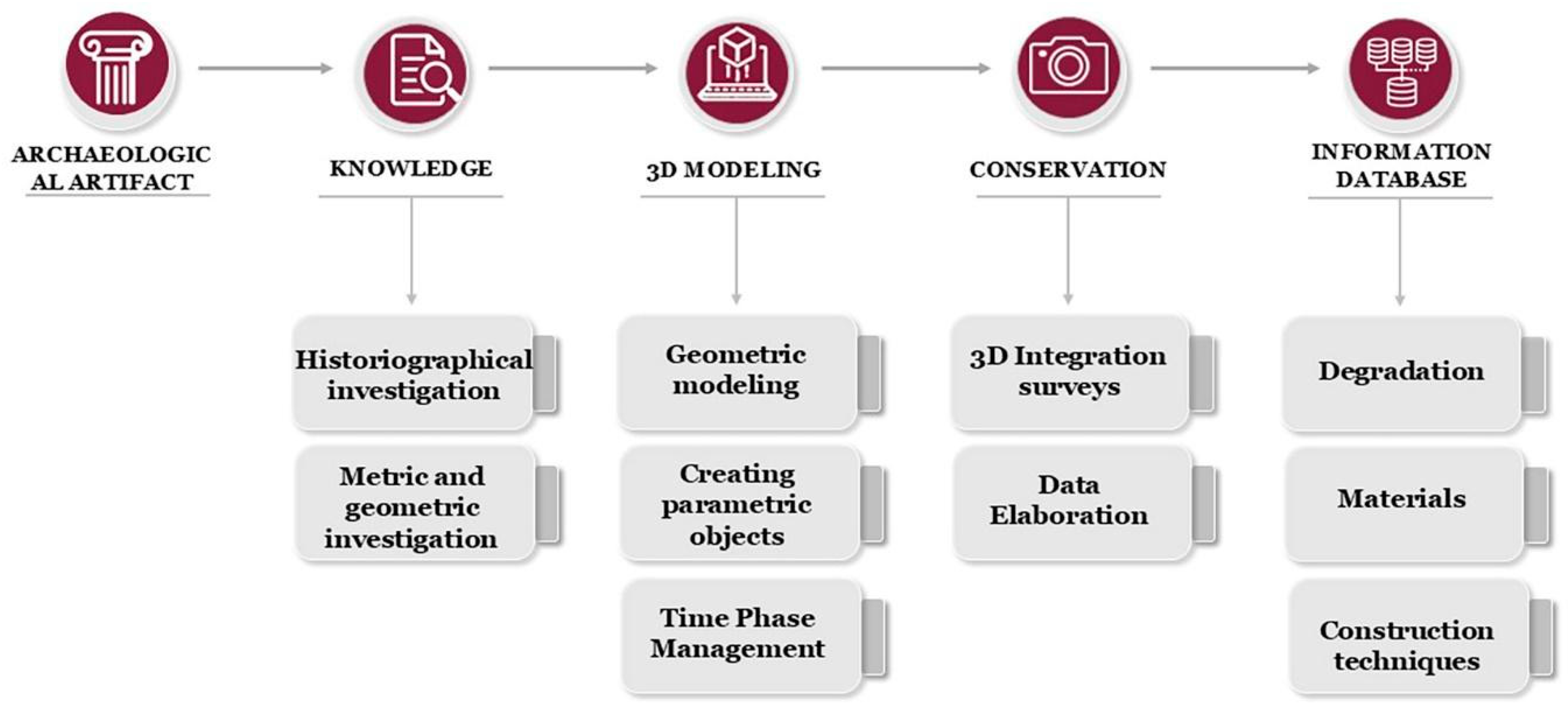
2. Materials and Methods
2.1. Integrated 3D Survey Techniques
2.1.1. The Unmanned Aerial Vehicle (UAV) 3D Survey
2.1.2. The Terrestrial Laser Scanning (TLS) Survey
2.1.3. Close-Range Photogrammetry for Mosaic Orthophotos Wall
2.2. GIS Platform
- The Macro Level examines the entire territory of ancient Abellinum, focusing on the Sabato River valley at its heart. This broader perspective combines geographical and cultural criteria to investigate the region’s geomorphology, settlement history, and the ancient landscape. Key sites identified through archival and bibliographic research are mapped as points in QGIS, and they have been catalogued thanks to a specially created table. This attribute table is organised into different sections: anagraphic aspects (ID, province, municipality, toponym, source, references), spatial and material aspects (definition, spatial reliability, surface, height), chronological aspects (chronology, chronological reliability, periodisation), and descriptive and interpretative aspects (description, interpretation). This makes it possible to carry out detailed analyses and queries based on selected fields and specific parameters. When available, excavation plans and site maps are georeferenced and represented as polylines, offering insights into the orientation and layout of structures. The GIS environment has also been populated with a number of other elements in an ESRI shapefile format drawn from both past and ongoing research related to primary and secondary road forms, hydraulic infrastructure (e.g., the Augustan and Samnite aqueducts), and agricultural subdivision schemes. All these elements fit on a heterogeneous cartographic base in raster formats, consisting of geological maps, DTM (with a resolution from 25 m to 1 m), different thematic maps obtained from the regional GIS website, i.e., IGM 1:25,000, as well as the hydrographic network in ashapefile format. The study conducted on this type of scale allowed for relating to Abellinum without considering it as an isolated entity but dropped into a specific territorial context. With a view to proceeding to the reconstruction of the ancient landscape, an attempt has been made to focus attention not only on the individual sites listed but also on the relationship between them over time and, above all, on the dynamics existing between man and the environment, also going on to investigate the connective tissue formed by the “empty” spaces existing between the sites, within which ancient communities lived and carried out their activities (Figure 5).
- The Intermediate Level shifts the focus to the Abellinum site itself, analysing its layout and how it connects to the broader territory. However, those spaces located in the immediate vicinity of the plateau are also taken into consideration, as they were intended for different functions in ancient times (burial areas, craft areas, entertainment areas) and directly connected to the life of the colony. Also in this case, a census of the evidence was carried out and its positioning in GISs, in the form of point and linear geometries. In the same geodatabase are added the results of different research activities, like ortophotos from drones, geophysical (georadar and geomagnetic) data from multiple surveys, and morphological features individuated both from field analysis and from the elaboration of detailed LIDAR data [34]. All of these data contributed to the reconstruction of the ancient landscape of the plateau (and its surroundings), which in ancient times must have presented greater heterogeneity from an altimetric point of view. The positioning of archaeological evidence was fundamental for the stratigraphic excavation planning activities (started in 2021) and for the research conducted on the urban organisation of the ancient city. It was decided to position all the data from archaeological research in GISs, including the often generic information collected by scholars and antiquarians of the past, as well as by contemporary enthusiasts and people who still live on site today, establishing a greater and lesser reliability criterion for each element. All this made it possible to define an extremely valuable database for research but also, in fact, an updated archaeological map, functional for protection and preventive archaeology activities. This level bridges the wide-scale regional analyses with the fine details explored at the micro level. Always operating on a medium scale, the activity carried out by the DiFarma (UNISA) team was also of great importance, which proceeded to the census and mapping of every plant species present on the Civita. This operation proved to be important in order to understand the status of local species and to become aware of the threats posed by alien and invasive species, both towards local flora and archaeological structures. (Figure 6).
- The Micro Level delves into specific archaeological contexts, focusing on excavation data and the reconstruction of individual features or areas within the site. As regards the aspects related to GISs, the inter-site scale approach is adopted mainly for the aspects connected to archaeological research in the field, in particular to archaeological excavation. This methodology has long been the standard practice in archaeological research activities and is also essential to comply with ministerial standards. Through the techniques of stratigraphic excavation, the survey activity via GNSS, total station and photogrammetry, and the study of the materials coming from the excavation itself, it is possible to have a representation in a GIS environment of the single stratigraphic unit, accompanied by a specifically structured attribute table containing all the main information (Figure 7). The attribute table created for stratigraphic units is different from the one described above for regional sites. It contains synthetic information related to descriptive aspects (ID number, typology, dimensions, height, findings) and excavation methods (technique, year of excavation, drawer).
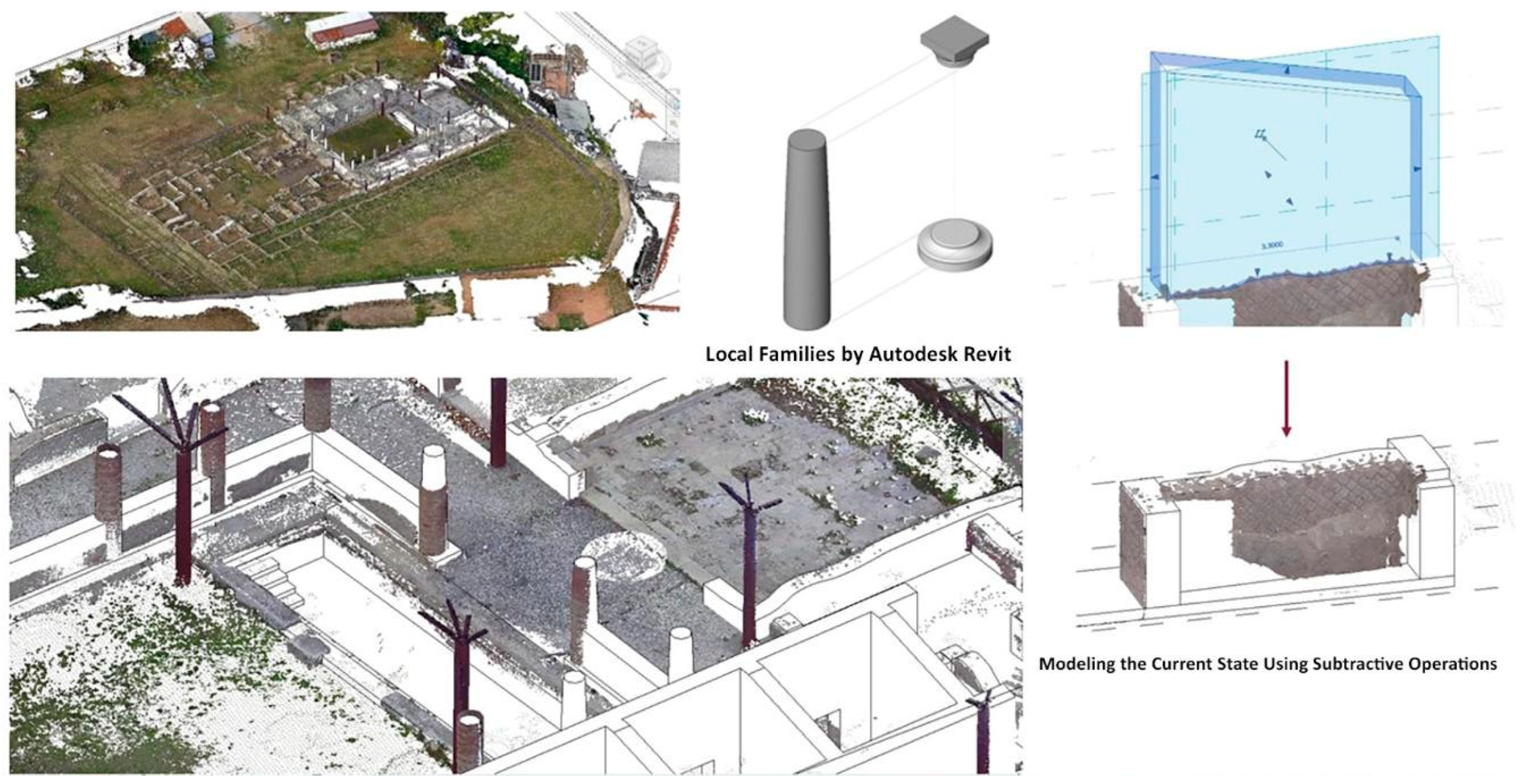
2.3. Scan-to-BIM Architectural Modelling
3. Results
3.1. Geometric Documentation
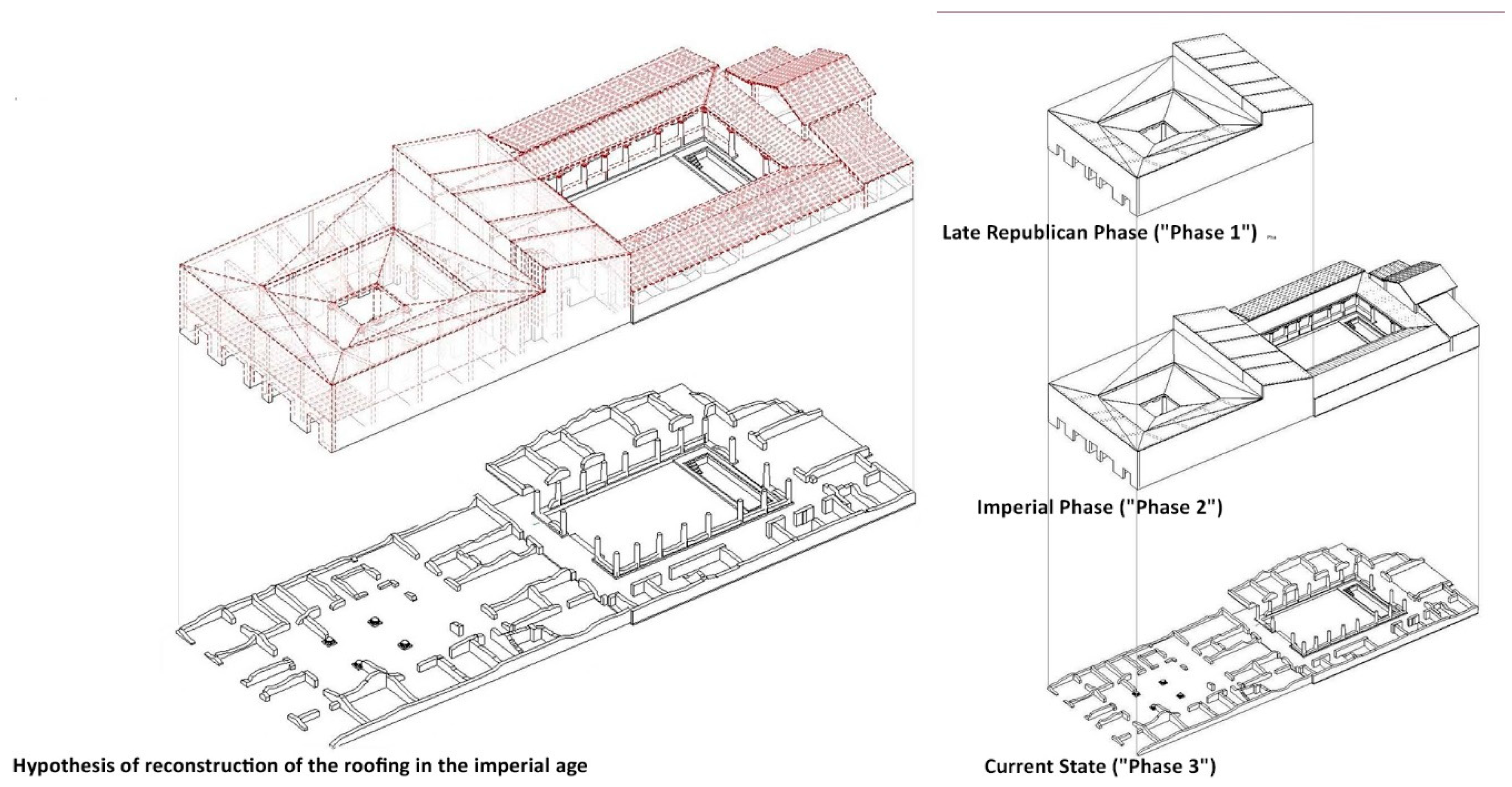
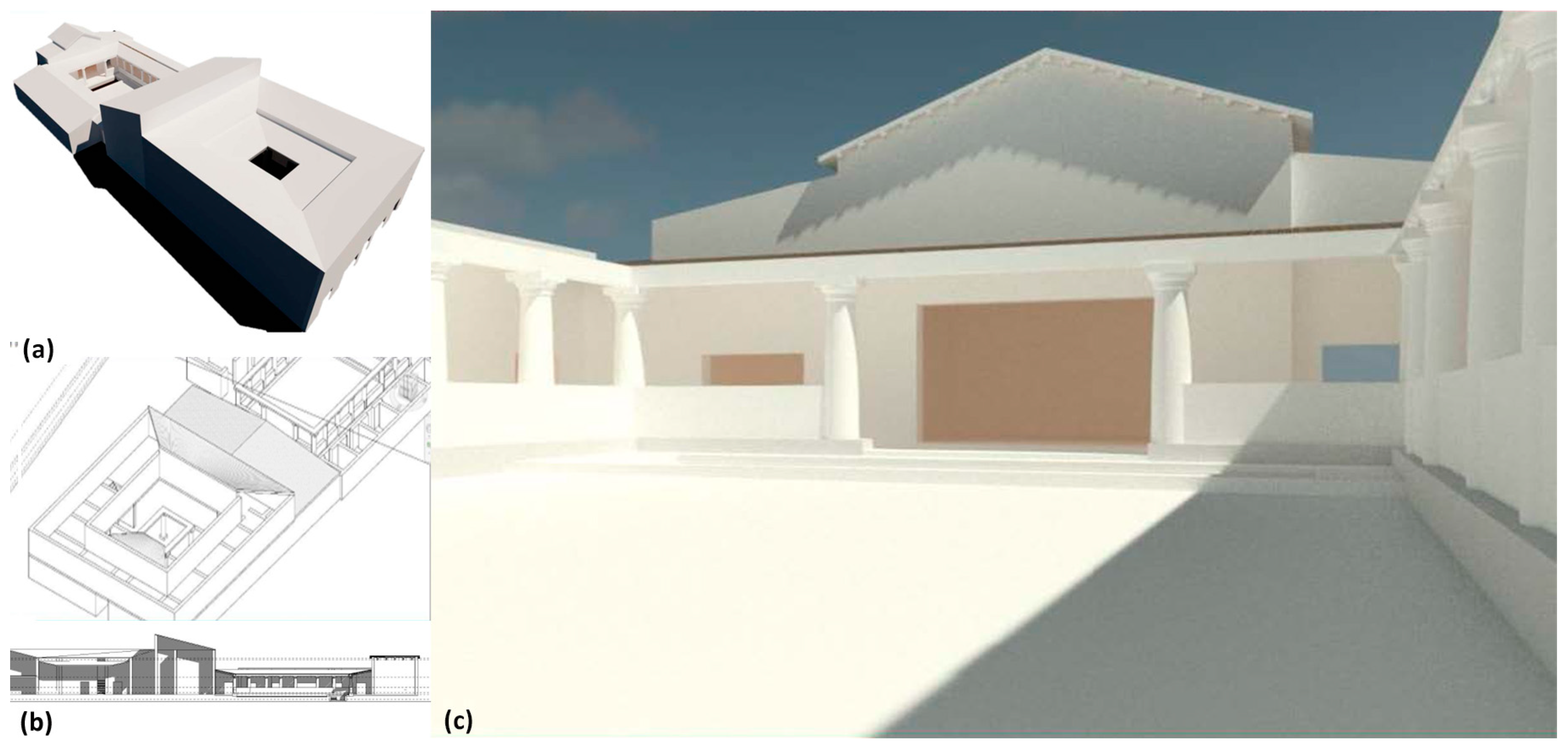
3.2. Multidisciplinary Documentation Data and HBIM Creation: Reconstruction Hypothesis
- Late Republican phase (“Phase 1”): This phase corresponds to the initial construction campaign centred on the atrium and the southern section of the domus. The original core exemplifies the atrium-style typology, featuring the vestibulum, cavum aedium, and impluvium. The construction techniques and proportions are consistent with Late Republican Roman residential architecture and align with Vitruvian principles.
- Imperial phase (“Phase 2”): This phase represents a significant architectural expansion, introducing the peristyle and surrounding rooms. The reconfiguration increased spatial complexity with the addition of representational spaces such as the alae and triclinium. The design proportions adhere to Vitruvian guidelines, underscoring the influence of De Architectura in shaping the domus’ architecture. With the onset of the crisis that brings a slow but steady depopulation of the Civita, the rooms of the domus cease to have a living and organic function, with them being split up, closed, and re-functionalised, and each one being destined for different production or storage activities; in this context, the conclusion of the domus’s living history can be identified.
- Current state (“Phase 3”): This phase captures the present condition of the domus, shaped by centuries of alterations, demolitions, and interventions. Excavation campaigns provided critical data for reconstructing the building’s evolutionary trajectory and documenting its current conservation state.
4. Discussion and Conclusions
Author Contributions
Funding
Data Availability Statement
Acknowledgments
Conflicts of Interest
References
- Colucci, E.; de Ruvo, V.; Lingua, A.; Matrone, F.; Rizzo, G. HBIM-GIS Integration: From IFC to CityGML Standard for Damaged Cultural Heritage in a Multiscale 3D GIS. Appl. Sci. 2020, 10, 1356. [Google Scholar] [CrossRef]
- Bianchini, C.; Inglese, C.; Ippolito, A.; Maiorino, D.; Senatore, L.J. Building Information Modeling (BIM): Great Misunderstanding or Potential Opportunities for the Design Disciplines? In Handbook of Research on Emerging Technologies for Digital Preservation and Information Modeling; Ippolito, A., Cigola, M., Eds.; IGI Global: Hershey, PA, USA, 2017; pp. 67–90. ISBN 9781522506805. [Google Scholar]
- Stanga, C.; Banfi, F.; Roascio, S. Enhancing Building Archaeology: Drawing, UAV Photogrammetry and Scan-to-BIM-to-VR Process of Ancient Roman Ruins. Drones 2023, 7, 521. [Google Scholar] [CrossRef]
- Grimaldi, M.; Giordano, C.; Graziuso, G.; Barba, S.; Fasolino, I. A GIS-BIM Approach for the Evaluation of Urban Transformations. A Methodological Proposal. WSEAS Trans. Environ. Dev. 2022, 18, 247–254. [Google Scholar] [CrossRef]
- Tsilimantou, E.; Delegou, E.T.; Nikitakos, I.A.; Ioannidis, C.; Moropoulou, A. GIS and BIM as Integrated Digital Environments for Modeling and Monitoring of Historic Buildings. Appl. Sci. 2020, 10, 1078. [Google Scholar] [CrossRef]
- Dore, C.; Murphy, M. Integration of Historic Building Information Modeling (HBIM) and 3D GIS for Recording and Managing Cultural Heritage Sites. In Proceedings of the 2012 18th International Conference on Virtual Systems and Multimedia, Milan, Italy, 2–5 September 2012; pp. 369–376. [Google Scholar]
- Bruno, N.; Rechichi, F.; Achille, C.; Zerbi, A.; Roncella, R.; Fassi, F. Integration of Historical GIS Data in a HBIM System. Int. Arch. Photogramm. Remote Sens. Spat. Inf. Sci. 2020, 43, 427–434. [Google Scholar] [CrossRef]
- Pepe, M.; Palumbo, D.; Dewedar, A.K.H.; Spacone, E. Toward to Combination of GIS-HBIM Models for Multiscale Representation and Management of Historic Center. Heritage 2024, 7, 6966–6980. [Google Scholar] [CrossRef]
- De Vita, C.B.; Limongiello, M.; Musmeci, D.; Santoriello, A. Tra Aerofotointerpretazione e Indagini Sul Campo: Linee Di Ricerca per La Ricostruzione Dell’insediamento Di Nuceriola (Benevento, Italia). J. Rom. Archaeol. 2023, 36, 126–156. [Google Scholar] [CrossRef]
- Bagnolo, V.; Argiolas, R.; Cuccu, A. HBIM for Archaeological Sites: From Sfm Based Survey to Algorithmic Modeling. In ISPRS Annals of the Photogrammetry, Remote Sensing and Spatial Information Sciences; Copernicus GmbH: Gottingen, Germany, 2019; Volume 42, pp. 57–63. [Google Scholar]
- Colosi, F.; Fangi, G.; Gabrielli, R.; Orazi, R.; Angelini, A.; Bozzi, C.A. Planning the Archaeological Park of Chan Chan (Peru) by Means of Satellite Images, GIS and Photogrammetry. J. Cult. Herit. 2009, 10, e27–e34. [Google Scholar] [CrossRef]
- Barba, S.; di Filippo, A.; Cotella, V.A.; Ferreyra, C. BIM Reverse Modelling Process for the Documentation of Villa Rufolo in Ravello. Disegnarecon 2021, 14, 1. [Google Scholar] [CrossRef]
- Intignano, M.; Biancardo, S.A.; Oreto, C.; Viscione, N.; Veropalumbo, R.; Russo, F.; Ausiello, G.; Dell’acqua, G. A Scan-to-bim Methodology Applied to Stone Pavements in Archaeological Sites. Heritage 2021, 4, 3032–3049. [Google Scholar] [CrossRef]
- Picone, R. Universal Design and Interoperable Digital Platforms between Conservation and New Fruition Opportunities. The Case Study of Arianna’s Domus in Pompeii. In Studies in Health Technology and Informatics; IOS Press BV: Amsterdam, The Netherlands, 2022; Volume 297, pp. 459–466. [Google Scholar]
- Chiabrando, F.; Sammartano, G.; Spanò, A. Historical Buildings Models and Their Handling via 3d Survey: From Points Clouds to User-Oriented Hbim. Int. Arch. Photogramm. Remote Sens. Spat. Inf. Sci. 2016, 41, 633–640. [Google Scholar] [CrossRef]
- Ronzino, P.; Acconcia, V.; Falcone, A. Towards the Integration of Spatial Data through the Italian Geoportal for Archaeological Resources. In Proceedings of the 2018 3rd Digital Heritage International Congress (DigitalHERITAGE) Held Jointly with 2018 24th International Conference on Virtual Systems & Multimedia (VSMM 2018), San Francisco, CA, USA, 26–30 October 2018; pp. 1–5. [Google Scholar]
- Sanseverino, A.; Messina, B.; Limongiello, M.; Guida, C.G. An HBIM Methodology for the Accurate and Georeferenced Reconstruction of Urban Contexts Surveyed by UAV: The Case of the Castle of Charles V. Remote Sens. 2022, 14, 3688. [Google Scholar] [CrossRef]
- Santoriello, A. Abellinum, Ricerche e Studi Sull’antico Centro Dell’Irpinia. Un Quadro Di Sintesi per Nuove Prospettive Di Ricerca. Ann. Archeol. E Stor. Antica 2023, 29, 71–88. [Google Scholar]
- Musmeci, D. Abellinum, La Vita Di Una Città. Note Di Sintesi e Nuovi Dati. Ann. Di Archeol. E Stor. Antica 2023, 29, 89–96. [Google Scholar]
- Antinozzi, S.; di Filippo, A.; Musmeci, D. Immersive Photographic Environments as Interactive Repositories for Preservation, Data Collection and Dissemination of Cultural Assets. Heritage 2022, 5, 1659–1675. [Google Scholar] [CrossRef]
- Colucci Pescatori, G. Evidenze Archeologiche in Irpinia. In La Romanisation Du Samnium Aux IIe et Ier Siècles Av. J.-C.; Actes du Colloque International: Naples, Italy, 1988; pp. 85–122. [Google Scholar]
- Fariello, M. Atripalda. In Proceedings of the XVIII Convegno di Studi sulla Magna Grecia, Taranto, Italy, 8–12 October 1978; pp. 313–316. [Google Scholar]
- Musmeci, D. Sui Sistemi Difensivi in Irpinia (IV-I Sec. a.C.). Un Quadro Di Sintesi Tra Dati Archeologici e «architettura Rappresentata». Otium. Archeol. Cult. Mondo Antico 2024, 15, 1–84. [Google Scholar] [CrossRef]
- Fariello Sarno, M. Abellinum Romana II. In L’Irpinia Antica; Pescatori Colucci, G., Ed.; Sellino & Barra Editors: Pratola Serra, Italy, 1996; pp. 113–128. [Google Scholar]
- Pescatori Colucci, G. Abellinum Romana I. In L’Irpinia Antica, Storia Illustrata di Avellino e Dell’irpinia; Pescatori Colucci, G., Ed.; Sellino & Barra Editori: Pratola Serra, Italy, 1996; Volume 1, pp. 97–112. [Google Scholar]
- Nava, M.L. Attività Della Soprintendenza per i Beni Archeologici Di Salerno, Avellino, Benevento e Caserta. In Proceedings of the XLIX Convegno di Studi sulla Magna Grecia, Taranto, Italy, 24–28 September 2009; pp. 741–746. [Google Scholar]
- Colucci Pescatori, G. Per Una Storia Archeologica Dell’Irpinia. In Studi Sull’irpinia Antica; Visconti, A., Lanzillo, M., Eds.; Tiotinx Edizioni: Napoli, Italy, 2021; pp. 149–204. [Google Scholar]
- Colucci Pescatori, G. Osservazioni Su Abellinum Tardo-Antica e Sull_eruzione Del 472 d.C.; Publications du Centre Jean Bérard: Napoli, Italia, 1986. [Google Scholar]
- Pagano, S.; Germinario, C.; Alberghina, M.F.; Covolan, M.; Mercurio, M.; Musmeci, D.; Piovesan, R.; Santoriello, A.; Schiavone, S.; Grifa, C. Multilayer Technology of Decorated Plasters from the Domus of Marcus Vipsanus Primigenius at Abellinum (Campania Region, Southern Italy): An Analytical Approach. Minerals 2022, 12, 1487. [Google Scholar] [CrossRef]
- Parrinello, S.; Picchio, F. Digital Strategies to Enhance Cultural Heritage Routes: From Integrated Survey to Digital Twins of Different European Architectural Scenarios. Drones 2023, 7, 576. [Google Scholar] [CrossRef]
- Butzer, K.W. Archaeology as Human Ecology: Method and Theory for a Contextual Approach; Cambridge University Press: Cambridge, UK, 1982; ISBN 9780521288774. [Google Scholar]
- Clarke, D.L. Analytical Archaeology; Routledge: London, UK, 1968. [Google Scholar]
- Campana, S. Carta Archeologica Della Provincia Di Siena. Volume XII. Montalcino; Nuova Immagine Editrice: Siena, Italia, 2013. [Google Scholar]
- Kokalj, Ž.; Hesse, R. Airborne Laser Scanning Raster Data Visualization: A Guide to Good Practice; Založba ZRC: Ljubljana, Slovenia, 2017; Volume 14. [Google Scholar]
- Saygi, G.; Agugiaro, G.; Hamamcıoğlu-Turan, M.; Remondino, F. Evaluation of GIS and BIM Roles for the Information Management of Historical Buildings. ISPRS Ann. Photogramm. Remote Sens. Spat. Inf. Sci. 2013, II-5/W1, 283–288. [Google Scholar] [CrossRef]
- Carandini, A.; D’Alessio, M.T.; Di Giuseppe, H. La Fattoria e La Villa Dell’Auditorium Nel Quartiere Flaminio Di Roma; L’Erma di Bretschneider: Roma, Italy, 2006; Volume 16. [Google Scholar]
- Lucchi, E.; Agliata, R. HBIM-Based Workflow for the Integration of Advanced Photovoltaic Systems in Historical Buildings. J. Cult. Herit. 2023, 64, 301–314. [Google Scholar] [CrossRef]
- Parrinello, S.; Dell’Amico, A. From Survey to Parametric Models: HBIM Systems for Enrichment of Cultural Heritage Management. In From Building Information Modelling to Mixed Reality; Bolognesi, C., Villa, D., Eds.; Springer International Publishing: Cham, Germany, 2021; pp. 89–107. [Google Scholar]
- Francesco, F.; Mandelli, A.; Frisoli, A.; Mandelli, A.; Terenzi, S.; Farella, E.; Fassi, F.; Achille. VR for Cultural Heritage. In Augmented Reality, Virtual Reality, and Computer Graphics; De Paolis, L.T., Mongelli, A., Eds.; Springer International Publishing: Cham, Germany, 2016; pp. 139–157. [Google Scholar]
- Murphy, M.; Meegan, E.; Keenaghan, G.; Chenaux, A.; Corns, A.; Fai, S.; Chow, L.; Zheng, Y.; Dore, C.; Scandurra, S.; et al. Shape Grammar Libraries of European Classical Architectural Elements for Historic Bim. Int. Arch. Photogramm. Remote Sens. Spat. Inf. Sci. 2021, 46, 479–486. [Google Scholar] [CrossRef]


Disclaimer/Publisher’s Note: The statements, opinions and data contained in all publications are solely those of the individual author(s) and contributor(s) and not of MDPI and/or the editor(s). MDPI and/or the editor(s) disclaim responsibility for any injury to people or property resulting from any ideas, methods, instructions or products referred to in the content. |
© 2025 by the authors. Licensee MDPI, Basel, Switzerland. This article is an open access article distributed under the terms and conditions of the Creative Commons Attribution (CC BY) license (https://creativecommons.org/licenses/by/4.0/).
Share and Cite
Limongiello, M.; Musmeci, D.; Radaelli, L.; Chiumiento, A.; di Filippo, A.; Limongiello, I. Parametric GIS and HBIM for Archaeological Site Management and Historic Reconstruction Through 3D Survey Integration. Remote Sens. 2025, 17, 984. https://doi.org/10.3390/rs17060984
Limongiello M, Musmeci D, Radaelli L, Chiumiento A, di Filippo A, Limongiello I. Parametric GIS and HBIM for Archaeological Site Management and Historic Reconstruction Through 3D Survey Integration. Remote Sensing. 2025; 17(6):984. https://doi.org/10.3390/rs17060984
Chicago/Turabian StyleLimongiello, Marco, Daniela Musmeci, Lorenzo Radaelli, Antonio Chiumiento, Andrea di Filippo, and Ilaria Limongiello. 2025. "Parametric GIS and HBIM for Archaeological Site Management and Historic Reconstruction Through 3D Survey Integration" Remote Sensing 17, no. 6: 984. https://doi.org/10.3390/rs17060984
APA StyleLimongiello, M., Musmeci, D., Radaelli, L., Chiumiento, A., di Filippo, A., & Limongiello, I. (2025). Parametric GIS and HBIM for Archaeological Site Management and Historic Reconstruction Through 3D Survey Integration. Remote Sensing, 17(6), 984. https://doi.org/10.3390/rs17060984