Review

Use of Tropospheric Delay in GNSS-Based Climate Monitoring—A Review

by
Aleksandra Maciejewska
Department of Integrated Geodesy and Cartography, AGH University of Krakow, Al. Mickiewicza 30, 30-059 Krakow, Poland
Remote Sens. 2025, 17(9), 1501; https://doi.org/10.3390/rs17091501
Submission received: 20 March 2025 / Revised: 21 April 2025 / Accepted: 22 April 2025 / Published: 24 April 2025
(This article belongs to the Special Issue Recent Progress in Monitoring the Troposphere with GNSS Techniques)

Abstract

:
The troposphere is a key component of the Earth’s climate system, modulating weather patterns and global temperatures through intricate interactions between water vapor, atmospheric pressure, and temperature. Nevertheless, the effective long-term monitoring of tropospheric variations continues to represent a significant challenge in the realm of climate science. While conventional methods such as radiosondes and satellite observations yield valuable data, they frequently face constraints related to temporal resolution, spatial coverage, or weather-dependent variations. In recent years, Global Navigation Satellite System (GNSS) meteorology has emerged as a promising alternative, offering continuous, high-precision atmospheric measurements. The objective of this review is to assess the application of GNSS tropospheric components in climate monitoring. Specifically, the following objectives are pursued: (1) examine how GNSS-derived ZTD, ZWD, and IWV reflect climate variability and long-term trends; (2) compare GNSS-based climate measurements with reanalysis and satellite datasets; (3) discuss the challenges and limitations of using GNSS for climate studies; (4) highlight future developments, including multi-GNSS integration and AI-driven climate data analysis.

1. Introduction

Climate monitoring is crucial for understanding the long-term changes occurring in the Earth’s atmosphere, especially in connection with anthropogenic factors and global warming. The troposphere, the lowest layer of the atmosphere, plays a critical role in regulating weather patterns, global temperature, and controlling moisture distribution in the Earth’s climate system [1,2,3,4]. Monitoring tropospheric conditions over extended periods is critically important for assessing climate variability, extreme weather trends, and future projections. Among the most salient atmospheric parameters in the domain of climate studies is water vapor, which functions as a key driver of the greenhouse effect and the hydrological cycle [5,6,7,8,9]. Although present in relatively low concentrations, water vapor plays a major role in atmospheric energy transfer in the atmosphere, as well as cloud formation, precipitation, and radiative forcing [10,11,12,13,14]. Nevertheless, the accurate measurement of tropospheric water vapor and other atmospheric components has proven to be a formidable challenge, largely due to the limitations inherent in conventional observation techniques [15,16,17,18].
Traditional methods employed for the purpose of atmospheric monitoring encompass the use of radiosondes, ground-based radiometers, and satellite remote sensing. The primary advantage of radiosondes is that they ensure vertical profiles of temperature, pressure, and humidity, yet this approach is hindered by their reliance on balloon launches, which, at operational weather stations, typically occur only twice a day [19,20,21,22,23,24]. Satellite instruments such as the Moderate Resolution Imaging Spectroradiometer (MODIS), the Atmospheric Infra-Red Sounder (AIRS), and the Global Ozone Monitoring Experiment-2 (GOME-2) provide large-scale observables of water vapor [25,26,27]. However, the effectiveness of these technologies is often constrained by factors including cloud cover, orbital limitations, and retrieval uncertainties. While these methods have contributed significantly to atmospheric research, they frequently lack the requisite precision, continuity, and global coverage necessary for long-term climate monitoring. Considering these challenges, alternative approaches have been investigated to enhance atmospheric observations, particularly through the implementation of Global Navigation Satellite System (GNSS) meteorology [28,29,30,31,32,33,34].
The GNSS, initially developed for the purpose of positioning and navigation, has evolved into a significant tool within the fields of atmospheric and climate sciences. When electromagnetic signals are transmitted from satellites to ground-based receivers, they undergo a delay due to the atmosphere, particularly in the troposphere [35,36]. This delay, known as tropospheric delay, consists of the Zenith Tropospheric (or Total) Delay (ZTD), which can be further divided into the Zenith Hydrostatic Delay (ZHD), caused by dry atmospheric gases such as oxygen and nitrogen, and the Zenith Wet Delay (ZWD), which is directly related to the water vapor content, making up only about 10–15% of the ZTD [37,38]:
Z T D = Z H D + Z W D
This means that the importance of water vapor lies more in its variability, which complicates modeling, rather than in its absolute contribution to the delay. A thorough analysis of these GNSS-derived delays can yield valuable insights into atmospheric moisture and other tropospheric properties. A prominent parameter obtained from GNSS meteorology is Integrated/Precipitable Water Vapor (IWV/PWV), which quantifies the total water vapor content within a vertical atmospheric column and can be calculated using the following formula [39]:
I W V = Z W D 10 6 ρ w R w k 3 T m + k 2 k 1 M w M d
where
ρ w —the density of liquid water;
R w —the gas constant of water vapor;
k 1 —77.6890 ± 0.015 K/hPa;
k 2 —71.2952 ± 10 K/hPa;
k 3 —375 463 ± 3000 K2/hPa;
M d —molar mass of dry air;
M w —molar mass of wet air;
T m —mean temperature along the GNSS signal propagation path in the troposphere.
IVW and PWV stand for the same information. However, the PWV value is adjusted by water density and finally expressed in millimeters [40]. In contrast to radiosondes and radiometers, the GNSS provides continuous, all-weather measurements with high temporal resolution, thereby making it a promising tool for climate monitoring [41,42,43,44,45].
Despite the extensive utilization of GNSS meteorology in short-term weather forecasting and numerical weather prediction (NWP) models, its potential for long-term climate studies remains underutilized [46,47,48]. However, recent studies show that GNSS tropospheric delay trends could serve as indicators of climate variability, providing insights into atmospheric moisture changes over time [49,50,51,52]. Despite these potential applications, several challenges remain in integrating GNSS data into climate research. Firstly, the global distribution of GNSS stations is uneven, with some regions having dense coverage while others, particularly in developing countries and remote areas, lack sufficient data. This can limit the spatial representativeness of GNSS-derived climate trends. Secondly, variations in the processing of GNSS data, such as the use of different mapping functions and temperature conversion models, can introduce biases and inconsistencies in long-term datasets. Thirdly, while reanalysis models, including ECMWF Reanalysis v5 (ERA5) and Modern-Era Retrospective Analysis for Research and Applications v2 (MERRA-2), provide valuable climate records, their integration with the tropospheric products derived from the GNSS requires further validation and standardization [50,53,54,55]. Addressing these issues is critical to ensuring the effective use of GNSS data for long-term climate studies.
Given the growing recognition of the GNSS as a valuable tool for atmospheric studies, this review aims to assess the application of GNSS-derived tropospheric components in climate monitoring. This paper is structured as follows: Section 2 introduces the key GNSS tropospheric components and their relevance to climate monitoring. Section 3 examines long-term climate trends derived from GNSS data, discusses the applications of GNSS-derived tropospheric data in climate research, and explores future developments in GNSS-based climate monitoring, including multi-GNSS integration and AI-driven analysis techniques. Finally, Section 4 concludes with a summary of key findings and recommendations for future research. The present review aims to provide a substantial overview of the role of GNSS tropospheric components in climate monitoring. In doing so, it offers novel insights into their potential applications and guides future research efforts in this emerging field.

2. GNSS Tropospheric Products

2.1. Zenith Troposheric Delay Components: ZTD, ZHD, and ZWD

The propagation of GNSS signals through the Earth’s atmosphere introduces significant errors due to atmospheric refraction. One of the most critical components of these errors is the tropospheric delay, which directly affects the accuracy of GNSS-based positioning and remote sensing applications.
The initial steps in the field of near real-time (NRT) and real-time (RT) analyses of the troposphere were made more than a decade ago. The first estimations concerned not only using additional meteorological data [23,56,57,58,59] but also solely GNSS observables [60,61,62]. After that, the research was focused on the application of the relatively innovative Precise Point Positioning (PPP) technique [63] and combining it with NRT, RT, and the numerical weather model [64,65,66,67,68,69].
The study by Ding et al. [64] evaluated the RT tropospheric delay estimation using GNSS PPP. A modified version of the PPP-WIZARD software processed observations incorporating data from the GPS, GLONASS, and Galileo. The experiment, which was conducted over a period of 30 days, analyzed the initialization time and accuracy of ZTD estimated across 20 global stations. The obtained results indicated that GPS-only solutions outperform GLONASS-only ones, while multi-GNSS integration enhanced convergence speed. Notably, the Ambiguity Resolution (AR) process in PPP significantly enhanced the accuracy of ZTD, reducing errors to an average of 8 mm with an initialization time of approximately 8.5 min. Comparisons with final troposphere products and radiosonde data confirmed the reliability of the proposed RT method for meteorological applications, particularly in nowcasting. The research highlighted the viability of GNSS-derived RT troposphere estimation for atmospheric studies. Lu et al. [68] proposed a sophisticated methodology for RT tropospheric delay retrieval using multi-GNSS Precise Point Positioning–Ambiguity Resolution (PPP-AR). Utilizing observations from 30 Multi-GNSS Experiment (MGEX) stations, the study evaluated the accuracy and efficiency of the proposed technique against the final troposphere products from the Center for Orbit Determination in Europe (CODE), the U.S. Naval Observatory (USNO), and the European Centre for Medium-Range Weather Forecasts (ECMWF). The findings revealed that the multi-GNSS PPP-AR method enhanced ZTD estimation accuracy by 16.7% and 31.7% in comparison to GPS-only solutions, attaining an average accuracy of 4.5 mm and 7.1 mm relative to CODE and USNO, respectively. The method also significantly reduced the initialization time by 50.7%. These findings underscore the potential of real-time multi-GNSS PPP-AR for enhancing meteorological applications, particularly for nowcasting and severe weather monitoring.
Hadas et al. [70] presented a thorough evaluation of RT ZTD estimation using GNSS, addressing significant advancements in processing strategies. The authors emphasized that despite the establishment of the IGS Real-Time Service in 2013, there has been only a marginal enhancement in the accuracy of RT ZTD, which typically ranges from 5 to 18 mm. The study explored the impacts of various processing parameters, including GNSS selection, inter-system weighting, elevation-dependent weighting, and gradient estimation. A newly proposed advanced strategy, incorporating multi-GNSS AR, has been demonstrated to reduce ZTD errors by 41% and improve accuracy by 17% relative to IGS final products (Figure 1). Furthermore, the study validated the latitude and seasonal dependence of ZTD accuracy.
Another case [20] concerned an improved strategy for modeling ZHD and weighted mean temperature (Tm) using GNSS and radiosonde data in conjunction with the GPT3 model and a multi-order Fourier function. Based on the investigation of seasonal variations in ZHD and Tm in the Yangtze River Delta region for the period between 2016 and 2020, the paper identified periodic inaccuracies in the GPT3 model. To maximize accuracy, the authors proposed the use of optimized ZHD and Tm models with the application of a third-order Fourier function, which the authors extensively evaluated with respect to in situ meteorological data at GNSS stations as well as data derived from radiosondes. The improved ZHD model correctly reduced the mean bias to −0.1 mm with an RMS error of 0.5 mm, while the improved Tm model minimized the mean bias to −0.6 K with an RMS error of 2.7 K—significantly surpassing GPT3 results. These improvements enabled more accurate estimates of PWV, providing significant improvements for high-precision meteorological and climatological applications, including satellite geodesy and atmospheric remote sensing.
Wilgan et al. [71] analyzed the integration of advanced multi-GNSS tropospheric parameters, including ZTDs, tropospheric gradients, and slant total delays (STDs). The analysis used observations from the GPS, GLONASS, and Galileo constellations. The analysis was carried out with the EPOS.P8 software, developed at GFZ Potsdam, to compare GNSS parameters with ECMWF ERA5 reanalysis data. The study’s findings revealed that all three GNSS configurations (GPS only, GPS–GLONASS, and GPS–GLONASS–Galileo) demonstrate strong agreement with ERA5, exhibiting biases of approximately 2 mm and standard deviations of 8.5 mm for ZTDs. Tropospheric gradients exhibited negligible biases with standard deviations of 0.4 mm, while standard deviations of STDs averaged at 26 mm, with an average bias of 4 mm. The enhanced observational geometry, particularly for low elevation angles, and the improvement in numerical weather prediction models that multiple GNSS constellations provided are noteworthy.
However, in recent years, experiments have been performed concerning creating ZTD models and interpolation methods for local or regional areas [72,73,74,75,76,77,78]. Xia et al. [73], in their work, established a high-accuracy real-time ZTD model for China by integrating data from over 500 GNSS stations and ERA5 reanalysis data. The model incorporated an elevation normalization approach (ENM) with annual, semiannual, and daily terms for unifying ZTD values across different elevations. A Gaussian-weighted distance function was optimized for interpolation to enhance the precision of ZTD estimates at grid points. The model, developed on a 1° × 1° grid, demonstrated a mean deviation of better than −0.09 cm and a root mean square error (RMSE) of less than 1.44 cm when evaluated against post-processed GNSS ZTD estimates (Figure 2). When employed in conjunction with PPP, the model has been shown to expedite convergence time in the vertical component by 37.4% and 38.6% at 95% and 68% confidence levels, respectively.
Recent advancements have demonstrated the potential of integrating reanalysis datasets with GNSS observations to improve the accuracy of tropospheric delay estimation, especially in challenging terrains. For instance, Lu et al. [77] developed a tropospheric delay model that combines ERA5 reanalysis data with GNSS-derived ZWDs from the Continuously Operating Reference Stations (CORS) network in the mountainous regions of eastern Australia. This integration capitalized on the high spatial resolution and uniform distribution of ERA5, complemented by the superior accuracy of GNSS-derived delays. This approach effectively mitigated the limitations of spatial interpolation over complex terrains with sparse station distribution and significant elevation variations. The proposed model demonstrated enhanced ZWD accuracy, achieving up to a 19.1% enhancement in mountainous eastern Australia compared to conventional CORS interpolation. Furthermore, the integration model facilitated accelerated PPP convergence and enhanced positional accuracy, with an improvement of up to 18.6% in the vertical component. This underscored the model’s capacity to refine atmospheric delay interpolation. Interpolating ZTD over areas with extensive spatial coverage and high elevation changes remains challenging with traditional approaches such as polynomial interpolation (POLI) and spherical harmonic interpolation (SHI). To address these challenges, a high-precision ZTD interpolation (HPZI) method was proposed, integrating GNSS-determined ZTD measurements with ERA5 reanalysis data. This method enhanced the separation and elimination of ZHD and ZWD by incorporating height correction models and enhancing interpolation at two reference planes with heights of 2500 m and 4400 m. Validation with 96 GNSS stations across the Qinghai–Tibet region indicated the superior performance of HPZI compared with the traditional approach, with RMSE values of 15.9 mm and 15.6 mm, respectively (Figure 3). The findings substantiated this method’s viability in enhancing GNSS-based atmosphere monitoring, particularly in regions characterized by intricate topography [78].

2.2. IWV/PWV: Estimation and Applications

Concurrently, with the advancement of satellite systems, there was an expansion in research in the domain of GNSS meteorology that went beyond the tropospheric delays to encompass investigations into atmospheric water vapor content. In particular, the use of GNSS-derived PWV has emerged as a key method for RT atmospheric monitoring, precipitation forecasting, and the development of optimized estimation techniques.
Wang and Zhang [79] were among the first to present a global, 2-hourly dataset of PWV derived from GPS measurements using the International GNSS Service (IGS) tropospheric products from 1997 to 2006. The dataset, covering 80 to 370 stations and augmented by the US SuomiNet (169 stations from 2003 to 2006), was employed for the evaluation of the radiosonde and reanalysis of the PWV data. They highlighted significant diurnal sampling errors in radiosonde data, reaching 10–15% for once-daily observations. Comparison with three reanalysis datasets (NCEP-NCAR, ERA-40, JRA) showed that elevation differences between reanalysis grid points and GPS stations cause PWV discrepancies, with correlation coefficients exceeding 0.84. An analysis of diurnal variations revealed peak-to-peak PWV amplitudes of 0.66 mm globally, 0.53 mm in the northern hemisphere, and 1.11 mm in the southern hemisphere. The peak occurred from noon to late evening, with significant seasonal and regional variability. Nevertheless, the calculation of the PWV value was further refined through the incorporation of RT/NRT estimation [41,80,81,82,83,84] and weather forecasting [31,43,44,85].
Building on this foundation, several studies have explored the value of GNSS-PWV data in nowcasting and precipitation forecasting. Li et al. [31] proposed a novel model for rain forecasting with the assistance of GNSS-PWV data. Utilizing a comprehensive analysis of a nine-year dataset (2010–2018) from 66 GNSS stations dispersed throughout the United States, the authors identified the absolute PWV value, the PWV increase, and the maximum hourly PWV increase as the top three predictive factors. To ascertain the most suitable threshold values for these variables, the researchers evaluated the critical success index and true skill statistic (TSS). Their findings indicated that the TSS offered superior predictability. The model’s validity was substantiated through the utilization of a two-year dataset (2019–2020), which revealed a probability of detection ranging from 73% to 97% (average: 87%) and a false alarm rate from 26% to 77% (average: 53%). The findings indicated that the model performs better in humid than arid environments. Wang et al. [86] presented a pioneering approach to dynamically map the movement of landfalling atmospheric rivers (ARs) over Southern California using high-rate GPS data from 79 stations. By deriving ZTD at 1 Hz, they constructed AR arrival time isochrones that reveal the southeastward movement of three ARs in January 2017, each traversing the region within ~10 hr. Critically, they justified using ZTD variations rather than PWV by confirming a strong correlation between the two, as found in their own study and later confirmed by Guo et al. [43]. This methodological choice allowed the precise spatiotemporal tracking of AR motion, with evidence of topographic modulation—ZTD isochrones were narrow over the peninsular ranges, indicating slower AR propagation. Notably, rapid AR motion near the Salton Sea correlated with high hourly precipitation (up to 13 mm h−1), supporting a robust relationship between isochrone spacing and precipitation intensity. Guo et al. [43] examined the impact of internal and external factors on GNSS-derived PWV for nowcasting. Based on observations from the BJFS station in Beijing, the study implemented Pearson correlation analysis to obtain the correlations between PWV and key meteorological parameters, such as ZTD, ZHD, ZWD, surface temperature (Ts), and pressure. The findings of the study indicated a strong correlation between PWV and ZTD (r = 0.9860), thereby substantiating the notion that ZTD serves as an effective indicator for short-term PWV variations. The study further demonstrated that variations in ZTD can forecast precipitation events with an 88.24% success rate, underscoring its potential for short-term weather forecasting. Furthermore, the study examined the impact of external factors, specifically the concentrations of PM2.5 during haze events, and demonstrated a strong relationship between GNSS-PWV/ZTD and air pollution concentrations. These findings underscored the potential of GNSS observations in haze monitoring, particularly in regions with limited conventional meteorological infrastructure.
Parallel to its use in forecasting, there has been considerable progress in refining the technical retrieval of ZTD and PWV. Xu et al. [82] conducted a study on real-time ZTD/PWV recovery using PPP with broadcast ephemerides (BE-PPP) as a viable alternative for traditional RT-PPP. The study validated GPS/Galileo observations from 80 IGS stations over a 30-day period for ZTD recovery and 20 EPN stations for PWV estimation. The findings, when validated with IGS final tropospheric products, radiosonde observations, and ERA5 reanalysis, demonstrated that BE-PPP was as precise as RT-PPP. The standard deviation of the BE-PPP ZTD was 1.07 cm, which was marginally larger than the 0.6 cm standard deviation of the RT-PPP. The PWV recovery had an STD of 1.69 mm (BE-PPP) compared to 0.96 mm (RT-PPP) when validated with ERA5 (Figure 4). When validated with radiosonde, the BE-PPP PWV STD was 3.09 mm, which was compatible with the requirement for numerical weather prediction accuracy. The study identified BE-PPP as a reliable supplement to RT-PPP, ensuring continuity in ZTD/PWV retrievals in the event of a disruption in the network and complementing the GNSS-based monitoring of the atmosphere.
In terms of regional-scale implementation, the establishment of an NRT GNSS-based IWV monitoring network for South America represented a substantial advancement in atmospheric observation. The system utilized existing geodetic and meteorological networks to generate hourly ZTD and IWV estimates for a vast region extending from central Brazil to the Antarctic Peninsula. This approach, which integrated the GNSS with surface meteorological measurements, presented a cost-effective alternative to conventional radiosonde measurements. A comprehensive validation (April 2018–March 2020) against independent GNSS-derived products, ECMWF ERA5 reanalysis data, radiosonde measurements, and AIRS measurements was conducted to confirm the high quality of the NRT products and their applicability for NWP use (Figure 5). A case study involving a mesoscale convective system further demonstrated the system’s capacity to identify rapidly evolving atmospheric behavior, thereby underscoring its value for meteorological and climate science research [84].

3. GNSS-Based Climate Monitoring

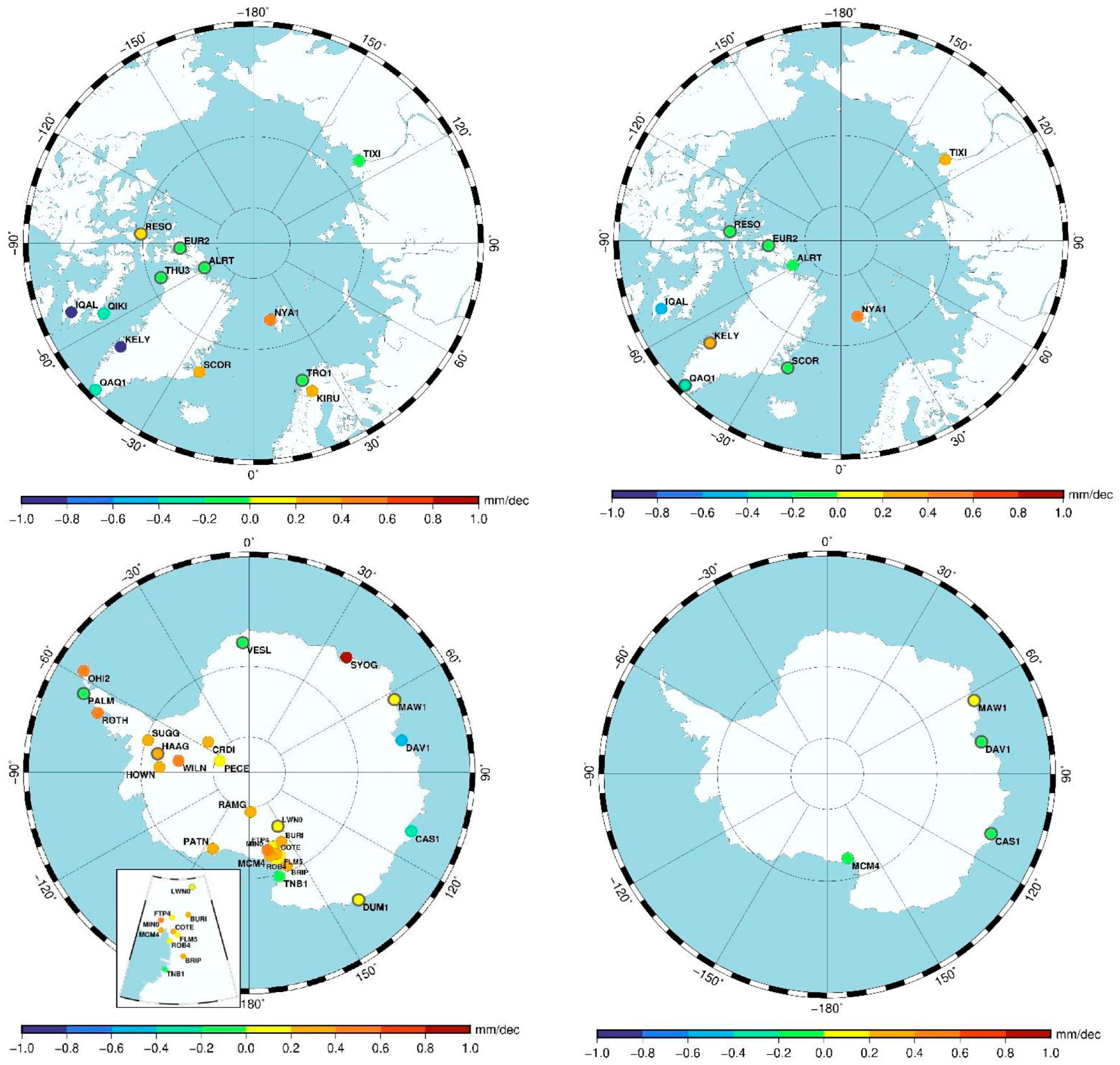
3.1. Climate Trends from GNSS

The long-term GNSS monitoring of ZTD and PWV is valuable for climate trend information, particularly for tracking changes in atmospheric water vapor. Because PWV is strongly correlated with surface temperature and humidity, GNSS observations allow the monitoring of long-term changes in regional and global moisture content. With GNSS datasets, researchers have been able to observe increasing PWV trends in many areas, consistent with increased temperatures and more active hydrological cycles [50,87,88]. The effects of climate change on atmospheric water vapor, extreme weather events, and precipitation variability at high spatial and temporal resolution can be quantified by examining multi-year GNSS records [4,20,40,52,89,90,91,92,93].
Patel and Kuttippurath [4] investigated the long-term trend in water vapor in the troposphere and its radiative effect on global warming. They employed satellite, radiosonde, and reanalysis records for the years 1980 to 2020. Their findings indicated that the global water vapor content in the troposphere is increasing at a rate of 0.025 to 0.1 kg/m2 per year, with the most pronounced growth observed in the Arctic region due to its accelerated warming (Figure 6). The mean water vapor content per year ranged from 5 to 60 kg/m2, with the maximum values observed in summer reaching 65 kg/m2 and decreasing to 5–20 kg/m2 in winter, apart from tropical regions. The trends in specific humidity were most pronounced at 1000 hPa in tropical regions, exhibiting an annual increase of 0.015 g/kg. This positive trend extended to most regions of the troposphere. The radiative effect resulting from rising water vapor was estimated to range from −5 to −70 W/m2 at the surface, with the maximum effects observed in tropical regions. Projections indicated that under a high-emissions scenario, polar region water vapor in the troposphere may double by the year 2100, thereby further accelerating global warming.
Negusini et al. [90] conducted a study of polar atmospheric water vapor variability, employing GNSS and radiosonde observations to compare the PWV from GNSS trends with the PWV from radiosondes and ERA-Interim. Utilizing a 20-year record from over 40 geodetic stations, the authors reported excellent correlation coefficients (0.96–0.98) and minimal RMSE ≤ 1 mm, thereby substantiating the reliability of PWV estimates derived from the GNSS. Positive PWV trends were identified at Arctic stations in the vicinity of the Atlantic, while negative trends were observed in Greenland and North America (Figure 7). The PWV obtained from GPS trends exhibited heterogeneity in Antarctica, with positive values in the West Antarctic sector and deep negative trends in some parts of East Antarctica. Generally, PWV retrieved from the RS trends was found to be insignificant. The research confirmed the GNSS as an efficient technique for monitoring atmospheric moisture, particularly in regions with a poor density of available data, to be used in conjunction with conventional meteorological methods. This enhanced the role of the GNSS in the trend analysis of climatology, providing insights into long-term hydrological and atmospheric changes resulting from climate fluctuations.

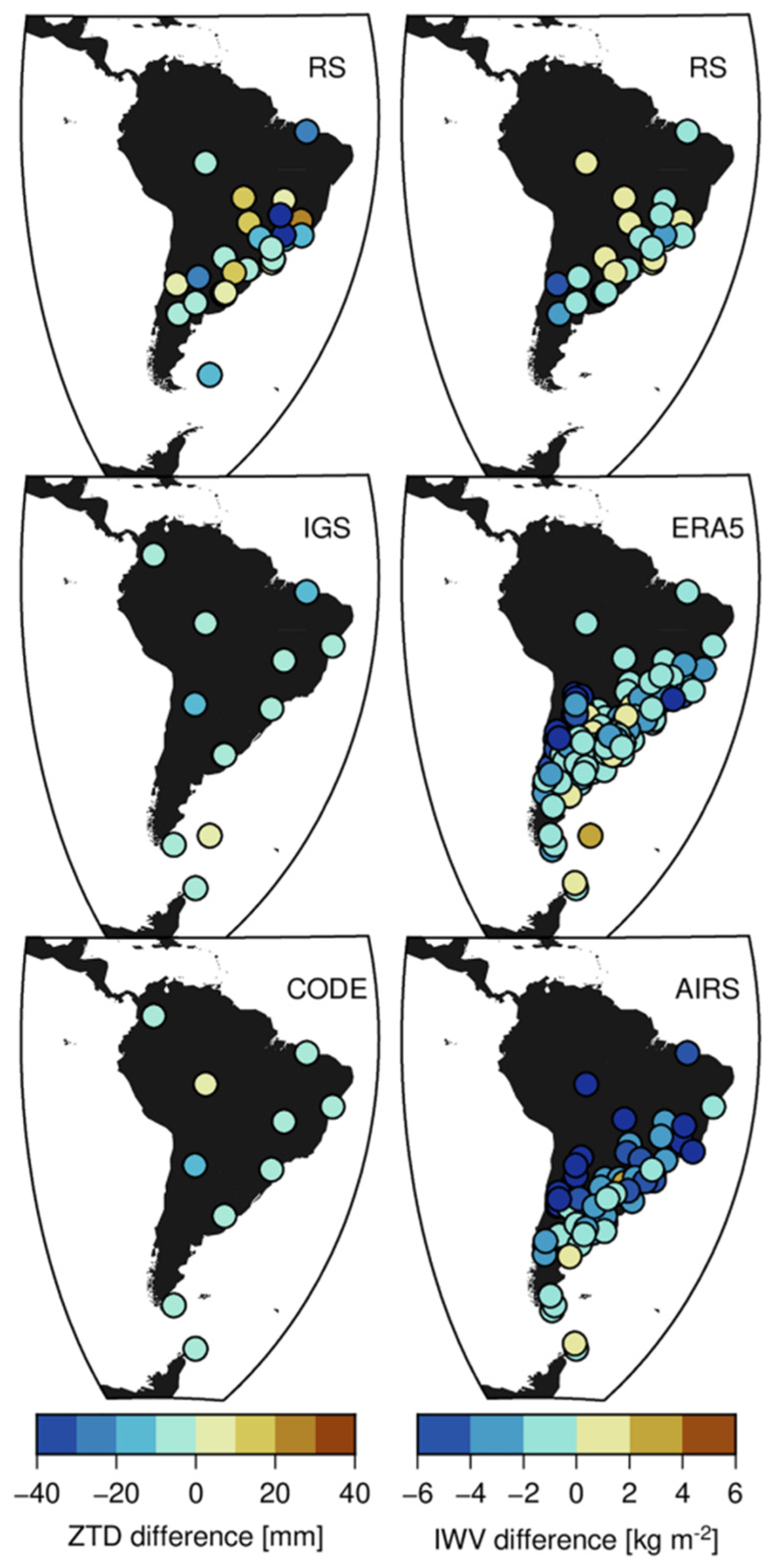
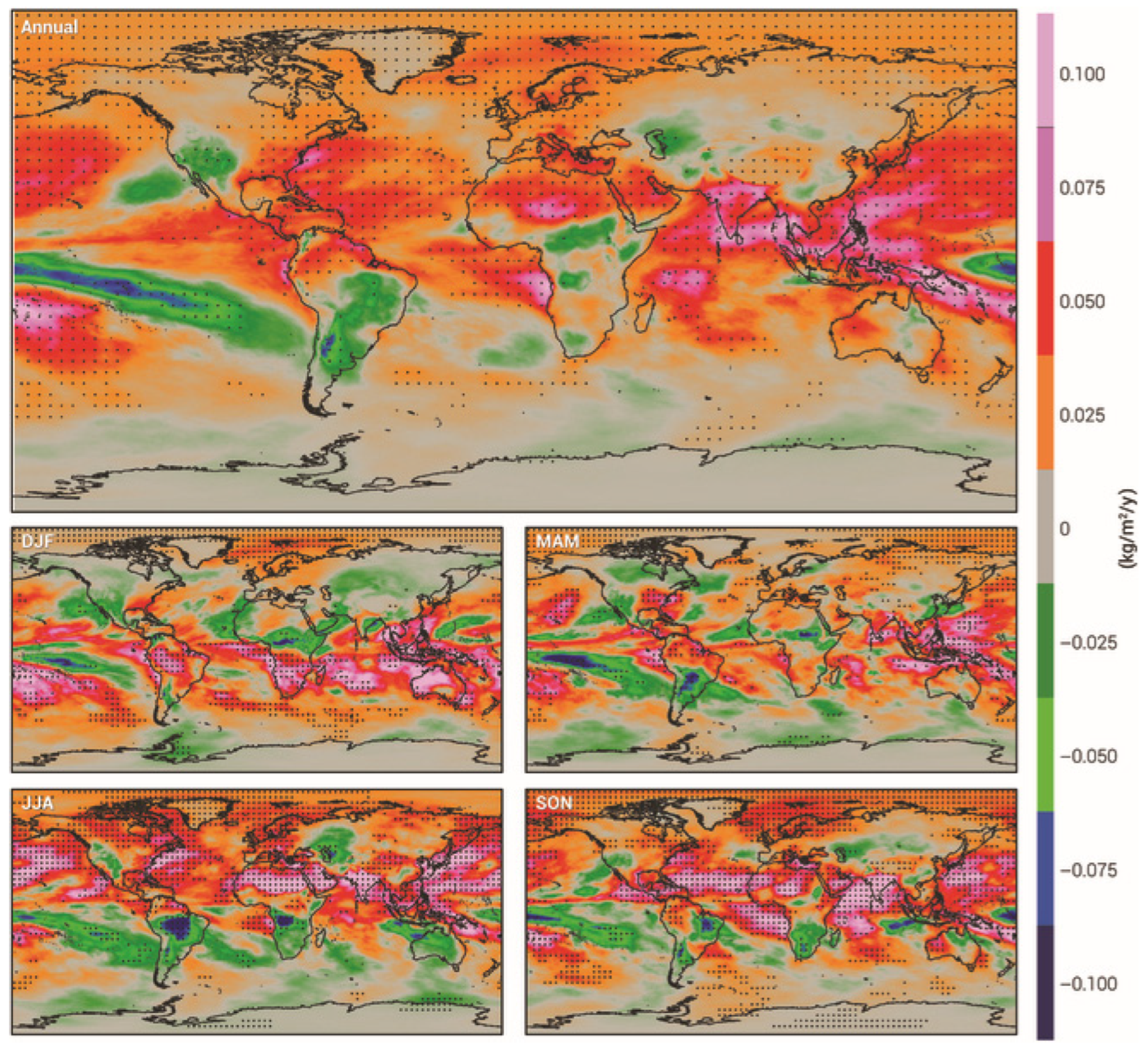
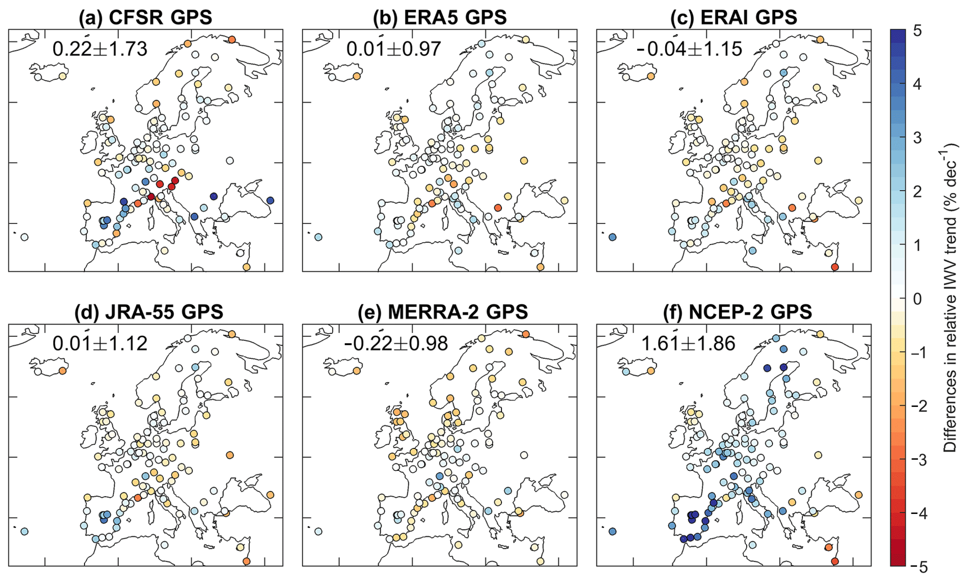
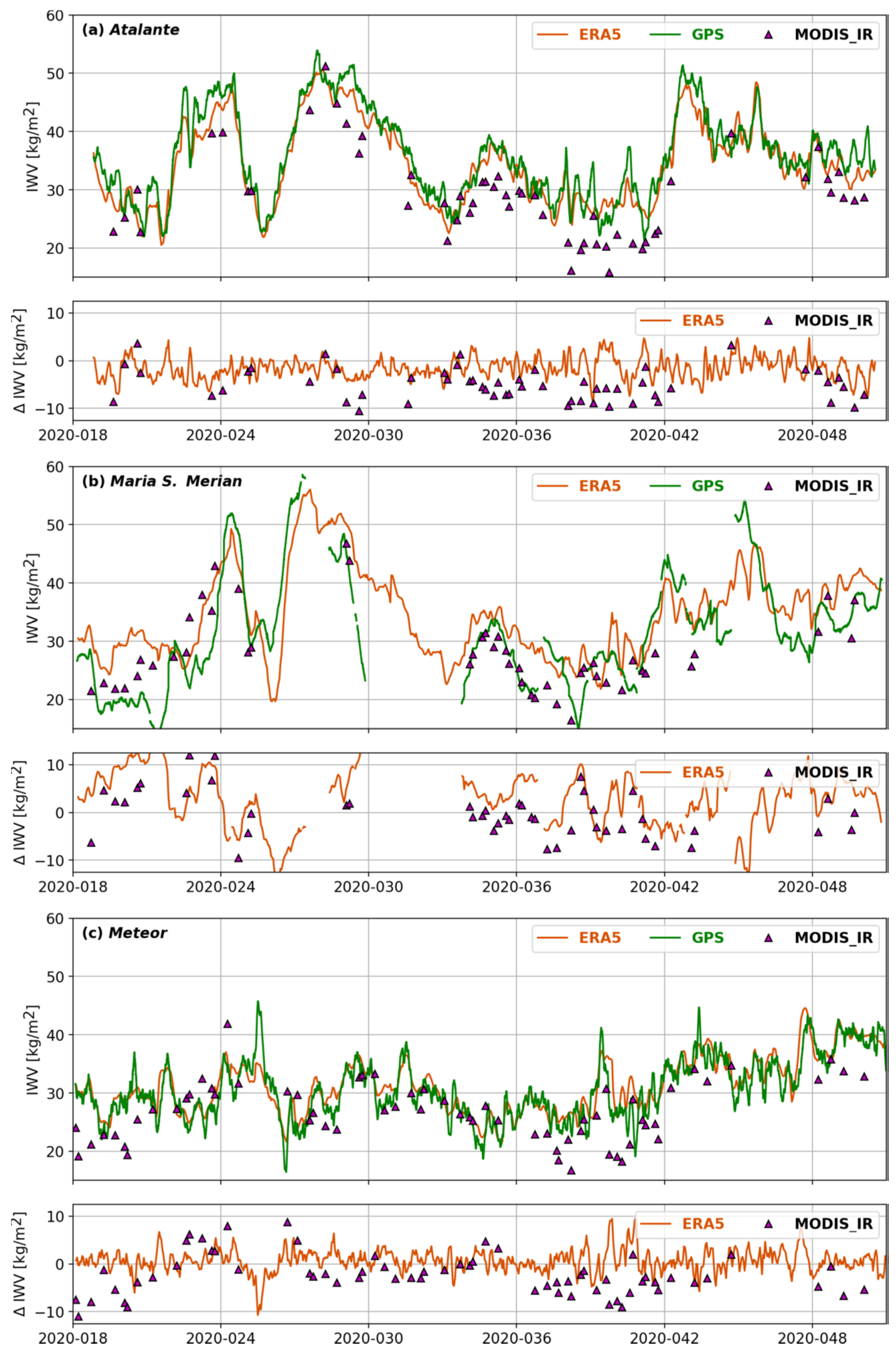
3.2. Integrating GNSS-Derived Water Vapor with Reanalysis Data for Climate Monitoring

Reanalysis datasets are employed as a valuable reference for the validation of GNSS-derived tropospheric products, offering spatiotemporally consistent atmospheric parameters. The integration of observational data with numerical weather models, as represented by reanalysis products such as ERA5, ERA-Interim, and MERRA-2, provides a homogeneous, long-term series of atmospheric parameters. Numerous studies have compared GNSS-based retrievals with reanalysis outputs to assess agreement across diverse climatic regions. This section presents the most relevant findings of recent studies, with an examination of the strengths and weaknesses of GNSS tropospheric products when validated against global reanalysis datasets [14,47,48,51,52,53,69,71,74,80,89,90,91,92,93].
The study [50] utilized two novel atmospheric reanalyses, namely ERA-Interim and MERRA-2, along with ground-based GPS observations, to examine trends and interannual variability in IWV. The study’s findings, based on the 1980–2016 period, revealed a general consistency in the distributions and interannual variability of IWV. However, a slight moist bias was observed in the extratropics and a dry bias in the tropics in the ERA-Interim compared to the GPS. MERRA-2 generally showed a more pronounced global moistening trend than ERA-Interim, particularly in the southern hemisphere. A thorough examination of the trend analysis revealed significant discrepancies in regions with inadequate in situ observations, such as Antarctica and northern Africa, where the ERA-Interim and MERRA-2 IWV trends diverge. The analysis underscored the modulating role of atmospheric circulation in dictating IWV variability, particularly in arid regions such as northern Africa and western Australia, where deviation from Clausius–Clapeyron scaling becomes evident. The analysis underscored the necessity of incorporating water vapor observations into reanalyses and identified GPS observations as the optimal benchmark for evaluating climate trends. Reanalysis datasets, however, offer global IWV fields with consistent spatiotemporal resolution but are subject to uncertainties due to differences in the assimilated input data, assimilation schemes, and physical parameterizations. Yuan et al. [55], in their study, utilized over two decades (1994–2018) of GPS-derived IWV at 108 stations across Europe to assess the consistency among the six most widely used reanalysis datasets: ERA5, ERA-Interim, JRA-55, MERRA-2, CFSR, and NCEP-2. Of the reanalyses, ERA5 demonstrated the most consistency with the GPS in depicting the diurnal, seasonal, and long-term variations in IWV, albeit with artificial shifts in its diurnal cycle due to assimilation edge effects. While ERA5 demonstrated an adequate representation of the trend in IWV, significant discrepancies were identified in CFSR and NCEP-2, particularly in southern Europe, hindering their suitability for analyzing climate trends. Figure 8 shows that ERA5 has the strongest agreement with the GPS in terms of IWV trends, with a minimal mean difference of 0.01% per decade and a low standard deviation of 0.97% per decade, indicating a significant improvement over its predecessor. JRA-55 shows a similarly low mean trend difference of 0.01% per decade, but with a slightly higher variability (1.12%). In contrast, MERRA-2 underestimates GPS trends by an average of 0.22% per decade, while CFSR overestimates them by the same margin. The figure also highlights the high standard deviation of CFSR trend differences (1.73% per decade), largely driven by discrepancies ranging from −5.1% to 4.9% in southern Europe, suggesting that CFSR data in this region must be used cautiously in climate trend analyses. The findings underscored the value of GPS IWV as an independent and reliable dataset for the validation of reanalysis, leading to a more accurate representation of atmospheric moisture and its role in weather and climate processes.
Yadav et al. [92] conducted an examination into the performance of ERA5 reanalysis data against GNSS-GPS-derived IWV for India. Utilizing the hourly estimates of IWV at 18 GNSS stations over a year, the examination systematically cross-checked the diurnal, seasonal, and space variations. The diurnal anomalies in IWV exhibited a range from −0.25 to 0.30 cm, with afternoon maxima and seasonality observed at most stations. The seasonal fluctuations in IWV exhibited summer monsoon maxima (3.88–6.29 cm) and winter minima (0.94–3.76 cm), attributable to the advection of moisture from the Arabian Sea and the local processes of convection. A comparison with ERA5 data yielded a high correlation coefficient (0.93–0.99), an RMSE of 0.21–0.38 cm, and a mean bias of −0.15 ± 0.21 cm. The findings of the study demonstrated the efficacy of ERA5 in capturing variations in IWV and its potential to enhance rainfall forecasts in regions with limited GNSS networks.
While the majority of GNSS-based IWV validation studies have focused on continental regions, recent research has extended this analysis to marine environments. The objective of these studies is to assess the performance of reanalysis over oceans, where data availability is limited, and satellite or shipborne GNSS retrievals offer an alternative means of IWV estimation. In a recent study, Bosser et al. [94] compared shipborne GNSS-derived IWV retrievals with ERA5 reanalysis and MODIS infrared (MODIS_IR) products during the 2020 EUREC4A campaign. The GNSS IWV retrievals conducted by research vessels (R/Vs) Atalante and R/V Meteor exhibited a concurrence with ERA5, exhibiting mean biases of −1.62 kg/m2 and +0.65 kg/m2, respectively, along with an RMS difference of approximately 2.3 kg/m2 (Figure 9). R/V Maria S. Merian showed higher RMS differences of 6 kg/m2 due to multipath effects. Larger discrepancies were observed with MODIS_IR, with RMS differences ranging from 5 to 7 kg/m2, representing increased uncertainties in satellite-based IWV retrievals for tropical oceans. The study also identified spatial and temporal biases in ERA5, including artificial shifts in diurnal variations due to assimilation effects.
Overall, the comparative analysis of GNSS-derived IWV with various reanalysis datasets consistently demonstrates the reliability of GNSS observations in a variety of geographic and climatic contexts. Studies have identified ERA5 as the most accurate and consistent reanalysis product, particularly with respect to seasonal and diurnal variability. However, regional biases and assimilation-related anomalies persist. GNSS observations are particularly valuable in regions with limited instrumentation, such as the tropics and the southern hemisphere, and are often considered the standard for validating long-term atmospheric moisture trends. It is noteworthy that discrepancies tend to increase in data-sparse environments, over oceans, or in regions with complex terrain, thereby emphasizing the complementary strengths of the GNSS and reanalysis. The integration of GNSS observations into climate datasets has been demonstrated to enhance spatial resolution, reduce uncertainty, and improve the characterization of IWV trends on both regional and global scales [95,96,97].
GNSS tomography is a technique that is used to reconstruct the three-dimensional distribution of atmospheric water vapor. This is achieved by analyzing slant wet delays from ground-based GNSS observations. This technique transforms the observed delays into wet refractivity fields, which are critical for comprehending atmospheric dynamics. A notable advantage of tomography over single-station retrievals is its ability to provide vertically and horizontally continuous spatial information. This method is particularly valuable in densely instrumented regions, where it can capture the fine-scale structures of the troposphere. Consequently, GNSS tomography has emerged as a pivotal instrument in the fields of meteorology, climate monitoring, and environmental geodesy. Xia et al. [98] propose a novel method, integrating ground-based GNSS tomography, GNSS radio occultation (RO), and radiosonde data. This approach enhances the three-dimensional retrieval of atmospheric wet refractivity, which is subsequently employed to derive temperature profiles and UHII values. To validate the approach, the authors conducted a case study using Hong Kong as a model. They compared the results with synoptic temperature records from five stations in 2020. The optimized tomography model exhibited a 16.5% enhancement in wet refractivity accuracy compared to conventional methods and achieved a temperature estimation accuracy of better than 1.35 K below 600 m. Furthermore, the root mean square deviation between UHII values derived from GNSS and meteorological data was approximately 1.20 K at a 95% confidence level. This integrated geodetic approach underscores the potential of GNSS tomography for near-real-time urban climate analysis, particularly in the context of variable seasonal water vapor conditions.

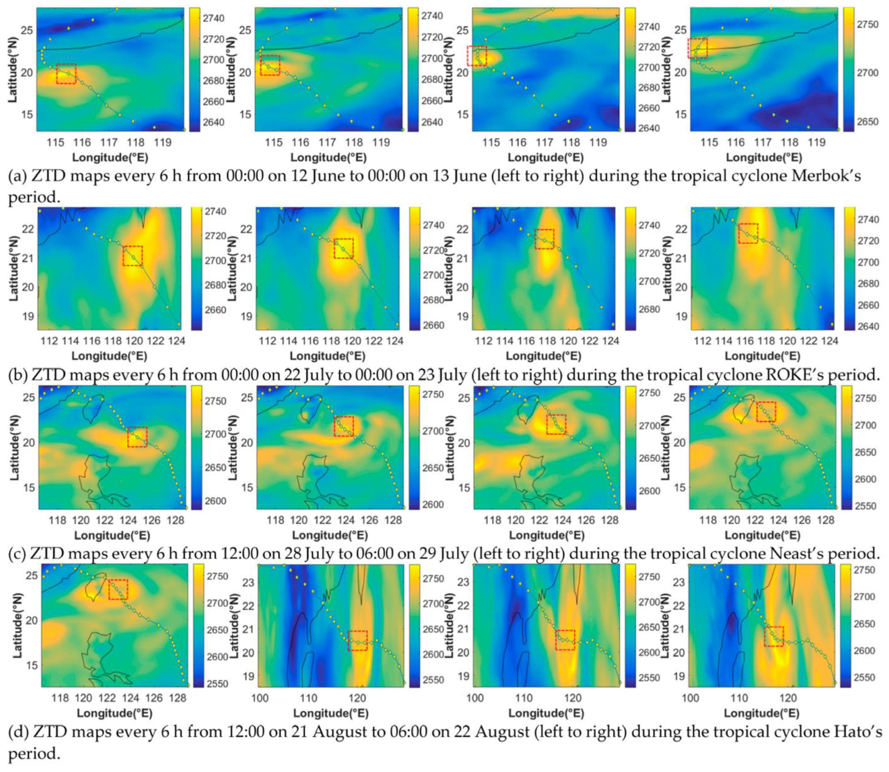
3.3. Extreme Weather Events

Extreme weather events, including but not limited to hurricanes, heavy rainfall, thunderstorms, and heatwaves, pose significant challenges to atmospheric monitoring and forecasting. These events are frequently marked by accelerated fluctuations in atmospheric water vapor, temperature, and pressure, which in turn affect the propagation of GNSS signals. Consequently, GNSS tropospheric products, such as ZTD, ZWD, and IWV have emerged as valuable tools for studying these extreme phenomena. These products offer high temporal and spatial resolution, facilitating the real-time monitoring and prediction of severe weather conditions. This section explores how extreme weather events impact GNSS signal propagation, the role of GNSS-derived tropospheric parameters in extreme weather detection, and recent advancements in using GNSS data for early warning systems and climate studies [47,52,69,81,99,100,101,102,103].
Rohm et al. [47] explored the use of GNSS-derived tropospheric products, specifically ZTD and IWV, for improving weather prediction. The research evaluated different GNSS data processing strategies, including Double-Differencing (DD) with short and long baselines and PPP, to determine the most reliable method for tropospheric delay estimation under extreme weather conditions. The findings indicated that DD short-baseline solutions provide the most robust and accurate ZTD/IWV estimates, with biases as low as −2.7 to −0.8 mm for ZTD and errors under 3 mm for IWV. Furthermore, GNSS-based tropospheric products contribute significantly to NWP models, enhancing the precision of real-time forecasting. The incorporation of GNSS meteorology into early warning systems has the potential to enhance their efficacy, thereby contributing to disaster preparedness and the mitigation of the consequences of extreme weather events.
The study [52] presented the variability of IWV, estimated using GPS measurements, during various stages of the Indian summer monsoon over Hyderabad. By examining data from 2014 and 2015, the study established correlations between IWV and key atmospheric variables, such as surface temperature and precipitation efficiency (P.E). The findings revealed a positive correlation between IWV and surface temperature under normal conditions. However, this relationship turned out to be negative during monsoon months, likely due to rainfall-induced cooling. Furthermore, the study underscored that IWV alone did not directly determine precipitation efficiency, emphasizing the necessity of dynamic mechanisms to facilitate condensation and rainfall formation. The analysis of diurnal variations in IWV during active and break monsoon spells further demonstrated that break spells exhibit higher amplitude oscillations than active spells.
Zhao et al. [99] presented a refined real-time tropospheric estimation strategy for severe weather monitoring, achieving a tropospheric accuracy of 8.77 mm using Precise Point Positioning. Their study, which was based on the July 2021 Henan rainstorm, demonstrates a high correlation (≥0.47) between PWV and extreme rainfall, with PWV values exceeding 50 mm before heavy rain events and dropping to around 35 mm post-rainfall. The estimated PWV from GNSS data aligned with ERA5 reanalysis, showing a standard deviation of 3 mm. The methodology employed, incorporating a sine2-type weighting function and a three-fold down-weighting for GLONASS/Galileo/BDS observations, enhances coordinate accuracy by 28.5% horizontally and 19.2% vertically. While PWV changes exhibited a close correlation with precipitation, horizontal gradients remained within ±4 mm, indicating atmospheric asymmetry rather than direct rainfall correlation. The findings underscored the potential of GNSS-based tropospheric monitoring to enhance the accuracy of extreme weather forecasting and early warning systems.
Li et al. [101] analyzed the relationship between GNSS-derived PWV and extreme weather events, particularly heavy precipitation in Hong Kong from 2010 to 2019. Their study’s findings indicated that prior to extreme rainfall events, there was a pronounced increase in PWV, subsequently followed by a precipitous decline. This phenomenon signified a substantial accumulation of moisture and a rapid process of condensation. During extreme events, the PWV decrement rate could reach up to 5.85 mm/h, indicating the imminent occurrence of heavy precipitation. Utilizing their five-predictor model, they achieved 189 out of 198 successful predictions of extreme rainfall events, with an average lead time of 5.15 h. In comparison to conventional methods, the proposed model exhibited a 32.9% reduction in false alarms, thereby enhancing the reliability of forecasts (Figure 10). The new model significantly reduced the number of incorrect predictions to 77, compared to 346 for the traditional method, resulting in a significant decrease in the FAR score from 61.8% to 28.9%. Despite this improvement, the POD scores of both methods remained comparable at 95% and 96%, with some cases showing perfect detection of heavy precipitation events. A closer look at the 77 false alarms shows that 54.5% corresponded to moderate precipitation and 23.4% to light precipitation within the following 12 h, while only 17 cases showed no precipitation. A notable extreme event that was analyzed was triggered by the tropical storm “Bebinca”. In this case, PWV spiked from 46.72 mm to 74.34 mm in 20 h before sharply declining, aligning with peak rainfall intensity above 25 mm/h.
Typhoons are among the most destructive natural phenomena affecting coastal and island regions, particularly in East and Southeast Asia. The development of these storms is driven by intricate interactions between oceanic heat, atmospheric moisture, and dynamic wind fields, frequently resulting in substantial socioeconomic and environmental ramifications. The accurate monitoring and prediction of typhoon behavior remain critical challenges in atmospheric sciences and geodetic remote sensing. He et al. [104] explored the utilization of GNSS-derived PWV for the RT characterization of Super Typhoon Mangkhut in Hong Kong. GNSS signals from ten CORS were processed using Bernese v5.2, achieving PWV accuracy with RMS differences below 2 mm compared to radiosonde data. The PWV time series exhibited substantial increases, with peak values reaching 77.8 mm, closely aligned with typhoon landfall. A significant correlation was identified between PWV and wind speed (r = 0.76), suggesting a dynamic relationship between moisture transport and typhoon intensity. A novel approach was developed to estimate typhoon movement direction and velocity using PWV arrival times across stations, validated against official meteorological data. Spatial PWV distributions, interpolated via Kriging, further confirmed the coherence between water vapor transport and typhoon trajectory. These findings underscore the potential of GNSS-PWV for short-term forecasting and early warning applications in coastal regions exposed to tropical cyclones, offering high temporal and spatial resolution. Lian et al. [105] proposed a novel methodology for monitoring the movement of tropical cyclones using GNSS-derived ZTD, emphasizing its potential as an alternative to PWV. The proposed method, designated as the TDOZA (Time Difference of ZTD Arrival), was evaluated through a series of tests utilizing ERA5-reanalysis ZTD data. Its performance was then validated against IGS post-processed ZTD and RS-derived PWV data. The ERA5-ZTD exhibited a mean bias of 6.4 mm, an RMS of 17.1 mm, and a standard deviation of 16.5 mm compared to IGS-ZTD, and it achieved a high mean correlation coefficient of 0.951 with radiosonde PWV, confirming its reliability. In Figure 11, the red dotted frame marks the central region of the tropical cyclone, where ZTD values are significantly higher than in the surrounding areas. Figure 11a–d shows that the movement of the yellow circle aligns with the trajectory of the cyclone, reflecting the spatial evolution of ZTD as the storm advances and retreats. This pattern—caused by elevated ZWD from moisture-laden air—demonstrates that ZTD can effectively track the direction of tropical cyclone movement, consistent with previous findings based on PWV analysis. The TDOZA model was applied to four tropical cyclones (Merbok, ROKE, Neast, and Hato) and successfully tracked movement velocities with a mean absolute deviation of 2.55 km/h and a relative error of 10.0%. These findings underscore the TDOZA model’s capacity to discern the spatiotemporal dynamics of tropical cyclones, thereby serving as an effective geodetic proxy for storm path prediction.
Zhang et al. [106] proposed an adaptive-degree layered function-based tomography (ALFT) method for GNSS tropospheric tomography. This method was developed for the purpose of improving the retrieval of 3D water vapor fields, particularly during severe weather events like typhoons. The efficacy of the proposed method was evaluated using data from 12 GNSS stations in Hong Kong during August 2017, when the city experienced typhoons Hato and Pakhar, which recorded peak daily rainfalls of 165.3 mm and 98.3 mm, respectively. The ALFT method was compared with radiosonde and ERA5 references. The method demonstrated a mean root mean square error (RMSE) of 0.81 kg/m3, representing a 34% improvement over the conventional function-based tomography (CFT) model (RMSE = 1.22 kg/m3). In the lower atmospheric layers (0–4 km), where water vapor is densest, ALFT reduced the mean ERA5-based difference from 0.85 kg/m3 to 0.57 kg/m3. These findings underscore ALFT’s augmented capacity to discern fine-scale vertical and horizontal moisture variability, particularly in dynamic meteorological contexts associated with typhoons. Furthermore, Zhang et al. [107] have introduced a novel multi-resolution GNSS tomography (MRGT) method tailored to the vertical and horizontal heterogeneity of atmospheric water vapor, particularly under extreme weather conditions such as typhoons. Utilizing GNSS and radiosonde data collected in Hong Kong during June–July 2015—a period marked by multiple rainstorms and typhoon influences—the authors demonstrated that the MRGT method outperformed conventional single-resolution tomography (SRGT). Specifically, the MRGT approach led to an 11.8% reduction in the RMSE of water vapor density profiles, with an average RMSE of 1.34 g/m3 compared to 1.52 g/m3 for SRGT. Furthermore, under conditions of rainfall with hourly intensities ranging from 4 to 12 mm, MRGT demonstrated a superior ability to accurately reconstruct vertical water vapor profiles, exhibiting a stronger correlation with radiosonde data compared to SRGT. Notably, the MRGT_865 scheme yielded the lowest slant water vapor RMSE of 4.45 mm. Figure 12 shows a comparison of the four SRGT schemes with the MRGT models, which revealed that the latter achieved higher accuracy, resulting in a reduction in the overall RMSE from 1.52 g/m3 to 1.34 g/m3—an enhancement of 11.8%. Despite having a lower horizontal resolution than MRGT_765, SRGT_6 produced a greater number of voxels but lower accuracy. Conversely, MRGT_765 effectively balanced voxel distribution by concentrating the resolution in the lower troposphere without significantly increasing the voxel count. A similar phenomenon was observed with MRGT_876 and MRGT_875, which, despite having fewer voxels (638 and 559, respectively) than SRGT_8 (896), demonstrated enhanced performance through a reduction in resolution in the mid-to-upper layers. This observation underscores the efficacy and precision of the MRGT approach. These findings underscore MRGT’s efficacy in assessing tropospheric moisture dynamics during typhoon-induced atmospheric disturbances.

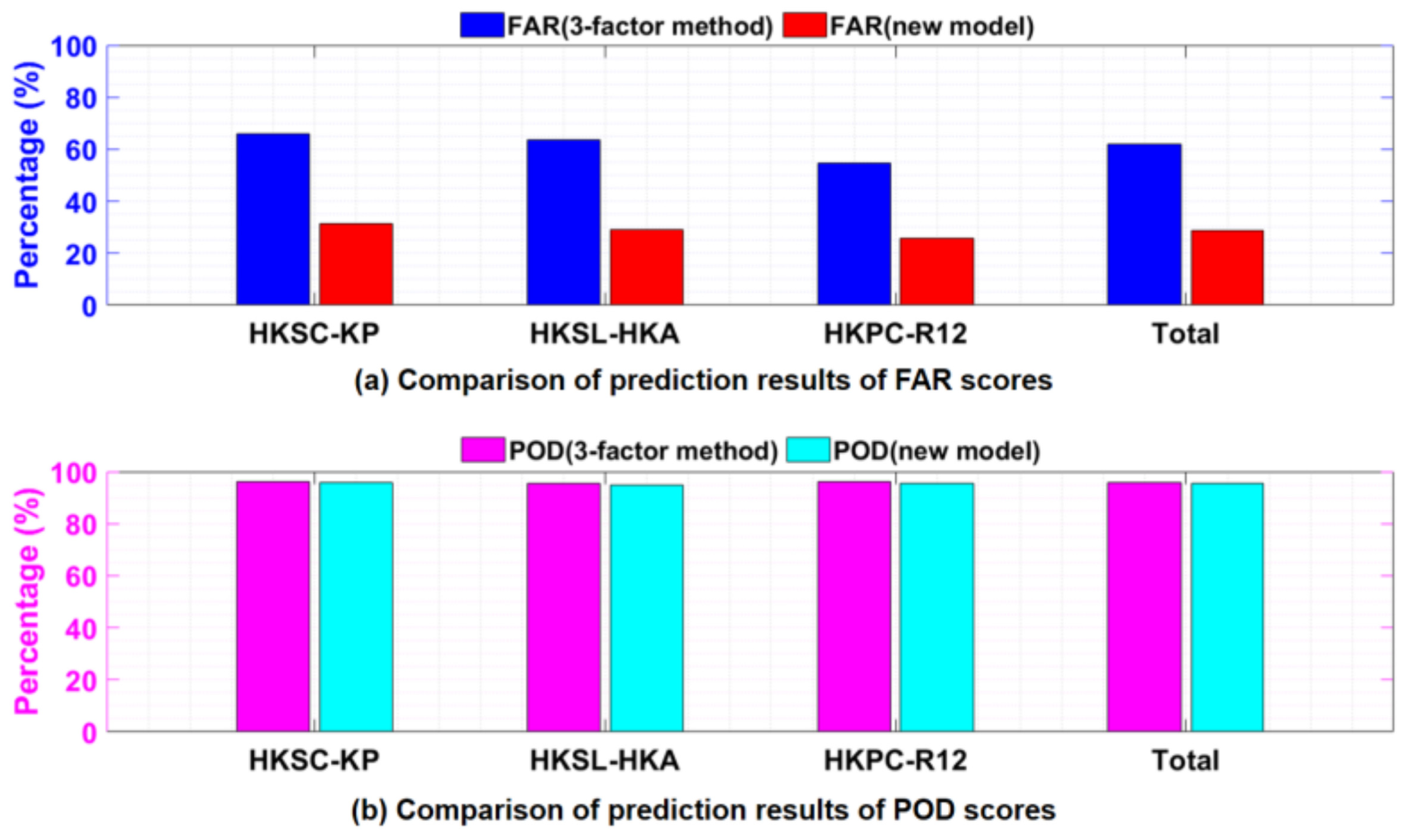
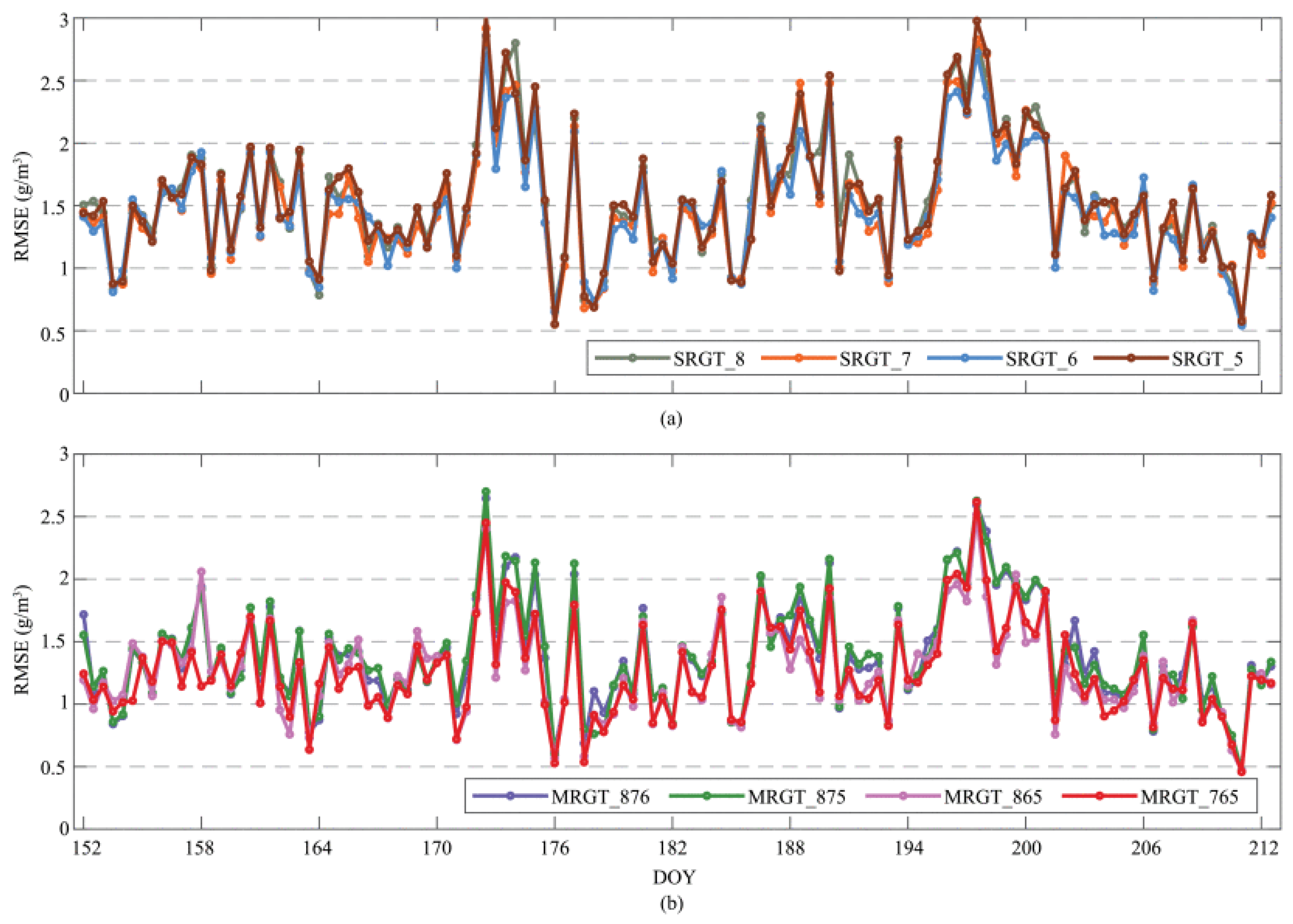
3.4. AI and Machine Learning

The advent of artificial intelligence (AI) and machine learning (ML) has precipitated a paradigm shift in the analysis of GNSS-derived tropospheric products, thereby enhancing the accuracy, automation, and predictive capabilities of climate monitoring. Conventionally, the processing of GNSS tropospheric data relies on deterministic models and statistical techniques, which, while efficacious, frequently encounter challenges due to nonlinear atmospheric variability and voluminous datasets. Conversely, AI and ML techniques, such as neural networks, deep learning, and ensemble learning, have emerged as potent tools for detecting patterns, optimizing data assimilation, and enhancing numerical weather prediction models. These approaches facilitate the identification of long-term climate trends, the assessment of extreme weather events, and the refinement of GNSS-based water vapor retrieval, thereby enhancing the comprehension of climate dynamics. This chapter explores recent advancements in AI-driven GNSS tropospheric studies, highlights key algorithms used in atmospheric modeling, and discusses their implications for climate research and forecasting [43,90,97,98,99,100,101,102,103,104,105,106,107,108,109,110,111,112,113,114,115,116,117,118,119].
Selbesoglu’s investigation [108] focused on the prediction of ZWD using an artificial neural network model that integrates GNSS and meteorological data. The study, conducted using data from the Austrian GNSS network (EPOSA), aims to enhance real-time weather forecasting by accurately estimating ZWD. The neural network model was trained using temperature, pressure, and relative humidity data from the New Austrian Meteorological Measuring Network (TAWES). The model’s performance was assessed through the analysis of validation results, which demonstrated its capacity to predict ZWD up to six hours in advance with an RMSE of 1.5 cm. This enhancement in accuracy surpassed that of conventional empirical models. The prediction error demonstrated seasonality, exhibiting higher accuracy in dry periods (0.80 cm RMSE) compared to humid conditions (1.58 cm RMSE). The findings demonstrated that neural network-based tropospheric delay estimation significantly enhanced GNSS meteorology applications, contributing to more accurate weather forecasts and extreme weather monitoring. Aichinger-Rosenberger et al. [115] presented an ML-based approach for detecting and predicting Alpine Foehn wind events using GNSS tropospheric products. The study, conducted at the Altdorf station in Switzerland, utilized 11 years (2010–2020) of GNSS-derived tropospheric parameters from the Automated GNSS Network in Switzerland (AGNES), along with meteorological Foehn observations. The authors of the study evaluated various classification algorithms and determined that Gradient Boosting (GB) and Support Vector Classifier (SVC) algorithms yielded optimal results, with probability of detection values ranging from 75% to 80% and false detection rates consistently below 2%. The model developed by the authors effectively identifies key predictors, including ZWD differences and tropospheric gradients, which exhibit a strong correlation with Foehn events. The incorporation of high-altitude stations and the reprocessing of GNSS products has been identified to enhance prediction accuracy. Notably, the incorporation of NRT data, despite its degradation of performance, demonstrates considerable promise for operational forecasting applications.
Haji-Aghajany et al. [111] presented an ML-based tropospheric delay prediction method to enhance RT-PPP under extreme weather conditions. Their study employed long short-term memory (LSTM) networks in conjunction with a genetic algorithm (GA) optimizer to predict wet refractivity in GNSS tomography. The prediction was made using datasets from Poland (rain bands) and California (storm events). The predicted wet refractivity was then incorporated into the tropospheric delay estimation via ray-tracing techniques, thereby enhancing the accuracy of PPP. A comparative analysis of three PPP setups was conducted: the first was the Com-PPP (standard method), the second was the Ray-PPP (using ray-tracing delays), and the third was the Dif-PPP (difference between estimated and GNSS-derived delays). The analysis revealed that Dif-PPP exhibits substantial enhancements, with a reduction in mean absolute error (MAE) ranging from 8% to 33% in static mode and a decrease in up-component convergence time by 6% to 17% in kinematic mode (Figure 13). The study’s findings underscore the significance of extreme weather conditions, which introduce substantial horizontal and vertical gradients in tropospheric delays. These gradients can be effectively mitigated by ML-based tomography.
Benevides et al. [117] have developed a neural network-based methodology for short-term intense rainfall forecasting using GNSS-derived PWV and meteorological data. Their study, which was based on five years (2011–2015) of data from a GNSS station in Lisbon, Portugal, integrates PWV with surface pressure, temperature, relative humidity, and cloud top measurements from SEVIRI satellite data. The study employed a nonlinear autoregressive exogenous (NARX) neural network model, which enhanced the prediction of hourly rainfall while significantly reducing false positive rates compared to traditional GNSS-PWV-based forecasting methods. The optimized neural network model attained a classification accuracy of 64% for intense rainfall events, accompanied by a false positive rate as low as 22%. In Figure 14, the model presents hourly rainfall forecasts derived from artificial neural networks alongside in situ measurements. The analysis reveals a strong correlation coefficient of 0.83, particularly for low-intensity events (<5 mm/h). While the model demonstrates proficiency in capturing general rainfall trends throughout 2015, it exhibits a tendency to underestimate higher intensity events and displays an increasing discrepancy with rising rainfall values. The analysis reveals seasonal patterns, with drier conditions from July to September and higher rainfall in January, April, and October, the latter of which displays notable noise around zero. The findings further demonstrated a nearly 100% success rate in differentiating between rain and no-rain conditions, underscoring the efficacy of AI-driven GNSS meteorology for extreme weather forecasting. Haji-Aghajany et al. [110] proposed a novel ensemble forecasting approach for 3D wet refractivity prediction using GNSS troposphere tomography integrated with machine learning techniques. To model tropospheric variations, LSTM networks were employed, with optimization via genetic algorithms (GAs). To enhance ensemble prediction, generative adversarial networks (GANs) were utilized to generate realistic time series. When applied to two climatically distinct regions, Poland and California, the method achieved RMSE values of 2.58–3.63 ppm and 2.29–3.18 ppm, respectively, for 1–3 h forecasts. Ensemble predictions further reduced the RMSE to 2.04–0.61 ppm across altitude layers, outperforming deterministic methods. Optimal classification thresholds were determined to be 0.41 (Poland) and 0.52 (California), yielding precision and sensitivity values of up to 0.993 and 0.982, respectively. These findings underscore the method’s robustness in forecasting tropospheric conditions across varying altitudes and climates, thereby enhancing GNSS-based meteorology with high-resolution, probabilistic predictions.

4. Conclusions

The increasing importance of climate monitoring in the context of global warming and anthropogenic climate change requires the continuous development of observational techniques. The troposphere, being the lowest layer of the atmosphere, plays a critical role in regulating weather patterns, global temperature distribution, and the hydrological cycle. Water vapor exerts a substantial influence on atmospheric energy transfer, cloud formation, and precipitation processes; consequently, its accurate measurement remains a cornerstone of climate sciences. However, traditional observation methods, including radiosondes, radiometers, and satellite-based remote sensing, exhibit notable limitations in terms of temporal resolution, spatial coverage, and susceptibility to weather-dependent variations. Consequently, there has been a growing and necessary effort to explore alternative techniques, with the aim of enhancing atmospheric monitoring capabilities. Through the analysis of the tropospheric delay experienced by GNSS signals as they traverse from satellites to ground-based receivers, researchers can derive critical atmospheric variables, including ZTD, ZWD, and IWV. A distinguishing feature of the GNSS is its capacity to provide continuous, all-weather observations with high temporal resolution, a capability that renders it particularly well suited for long-term climate studies. For instance, GNSS networks have the capacity to provide atmospheric measurements at intervals as brief as five minutes, in contrast to the 12 h interval typical of radiosonde launches. This provides significantly higher temporal resolution. This advantage places the GNSS in a unique position to complement and, in some cases, outperform traditional observation methods.
Despite these advantages, the interpretation of GNSS-derived climate signals remains subjected to several considerations. For instance, regional variations in GNSS station density can impact the representativeness of climate trends derived from GNSS data. While densely instrumented regions, such as Europe and North America, benefit from extensive GNSS networks, data coverage remains sparse in remote and developing regions. To illustrate, Europe hosts over 25% of all GNSS ground stations, while Sub-Saharan Africa accounts for less than 3%, highlighting a stark disparity in observational infrastructure. This imbalance presents a structural challenge to the equitable application of GNSS technology in global climate science. Addressing this issue requires international collaboration to expand GNSS infrastructure and improve data availability across diverse geographic settings. Furthermore, the presence of uncertainties in GNSS-based climate records can be attributed to variations in data processing methodologies, including differences in mapping functions, temperature conversion models, and tropospheric delay estimation techniques. These inconsistencies introduce a non-trivial risk of bias in long-term climate analysis and emphasize the need for rigorous methodological standardization. To ensure the consistency and reliability of GNSS-derived climate datasets, it is essential to standardize data processing protocols and implement robust calibration procedures. Comparative analyses between GNSS-based climate observations and other atmospheric datasets have highlighted both the strengths and limitations of GNSS meteorology. On the one hand, GNSS-derived IWV has been shown to exhibit strong agreement with reanalysis products such as ERA5 and MERRA-2. In certain instances, the correlation coefficients between GNSS-derived IWV and ERA5 have been observed to exceed 0.95, thereby validating the method’s efficacy in moisture retrieval across a diverse spectrum of climatic conditions. This convergence lends credibility to GNSS-derived moisture estimates and validates their broader potential utility for climate monitoring.
In consideration of prospects, a series of pivotal advancements are anticipated to enhance the role of GNSS meteorology in climate research. The integration of multi-GNSS data from multiple satellite systems offers the potential to improve spatial and temporal coverage, thereby strengthening the robustness of GNSS-derived climate records. Furthermore, advancements in AI and ML techniques are creating new opportunities for the analysis of large-scale atmospheric datasets. Specifically, AI-driven approaches hold the potential to automate the detection of climate trends, enhance data quality control procedures, and optimize GNSS signal processing techniques. When effectively implemented, these innovations could significantly accelerate both the scale and precision of climate analysis using the GNSS.
In summary, GNSS meteorology is a powerful tool for climate monitoring, offering continuous, high-precision measurements of atmospheric parameters. The analysis of GNSS-derived ZTD, ZWD, and IWV has yielded valuable and credible insights into climate variability, with demonstrated correlations to temperature trends, precipitation patterns, and large-scale climate oscillations that reinforce GNSS’s scientific value. Comparisons with reanalysis and satellite datasets have not only affirmed the reliability of GNSS-based climate observations but also revealed key areas where methodological refinement and data integration are still urgently needed. Despite its strong potential for long-term climate studies, GNSS meteorology still faces critical challenges, notably the uneven global station distribution and the lack of standardized data processing protocols, which risk undermining data consistency. Addressing these challenges necessitates sustained investment in GNSS infrastructure and collaborative research, as well as the strategic integration of emerging technologies, such as artificial intelligence and multi-GNSSs, to fully realize the potential of GNSS meteorology. The efficacy of GNSS meteorology in advancing climate science is contingent on the community’s ability to address these structural and methodological challenges. The demonstrated strengths of the GNSS, when coupled with evolving technical innovations, position it not merely as a supportive tool, but as a potentially central component of global climate monitoring frameworks.

Funding

This research received financing through the option of OPEN ACCESS, publications in commercial scientific journals of high IF, and subsidizing journals published by AGH University of Krakow by Excellence Initiative—research university program (Action 9) (research subvention no. 16.16.150.545).

Data Availability Statement

No new data were created or analyzed in this study. Data sharing is not applicable to this article.

Conflicts of Interest

The author declares no conflicts of interest.

References

  1. Speight, J.G. Natural Water Remediation; Elsevier: Amsterdam, The Netherlands, 2020; ISBN 9780128038109. [Google Scholar]
  2. Holton, J.; Hakim, G. An Introduction to Dynamic Meteorology; Elsevier: Amsterdam, The Netherlands, 2013; ISBN 9780123848666. [Google Scholar]
  3. Colman, R.A. Climate Radiative Feedbacks and Adjustments at the Earth’s Surface. J. Geophys. Res. Atmos. 2015, 120, 3173–3182. [Google Scholar] [CrossRef]
  4. Patel, V.K.; Kuttippurath, J. Increase in Tropospheric Water Vapor Amplifies Global Warming and Climate Change. Ocean-Land-Atmos. Res. 2023, 2, 15. [Google Scholar] [CrossRef]
  5. Peixóto, J.P.; Oort, A.H. The Atmospheric Branch of the Hydrological Cycle and Climate. In Variations in the Global Water Budget; Springer: Dordrecht, The Netherlands, 1983; pp. 5–65. [Google Scholar]
  6. Acker, J.; Williams, R.; Chiu, L.; Ardanuy, P.; Miller, S.; Schueler, C.; Vachon, P.W.; Manore, M. Remote Sensing from Satellites. In Encyclopedia of Physical Science and Technology; Elsevier: Amsterdam, The Netherlands, 2003; pp. 161–202. [Google Scholar]
  7. Rasmussen, R.; Khalil, M. The Behavior of Trace Gases in the Troposphere. Sci. Total Environ. 1986, 48, 169–186. [Google Scholar] [CrossRef]
  8. Held, I.M.; Soden, B.J. Robust Responses of the Hydrological Cycle to Global Warming. J. Clim. 2006, 19, 5686–5699. [Google Scholar] [CrossRef]
  9. Dai, A. Recent Climatology, Variability, and Trends in Global Surface Humidity. J. Clim. 2006, 19, 3589–3606. [Google Scholar] [CrossRef]
  10. Bony, S.; Stevens, B.; Frierson, D.M.W.; Jakob, C.; Kageyama, M.; Pincus, R.; Shepherd, T.G.; Sherwood, S.C.; Siebesma, A.P.; Sobel, A.H.; et al. Clouds, Circulation and Climate Sensitivity. Nat. Geosci. 2015, 8, 261–268. [Google Scholar] [CrossRef]
  11. Haji-Aghajany, S.; Amerian, Y.; Amiri-Simkooei, A. Function-Based Troposphere Tomography Technique for Optimal Downscaling of Precipitation. Remote Sens. 2022, 14, 2548. [Google Scholar] [CrossRef]
  12. Gauss, M.; Myhre, G.; Pitari, G.; Prather, M.J.; Isaksen, I.S.A.; Berntsen, T.K.; Brasseur, G.P.; Dentener, F.J.; Derwent, R.G.; Hauglustaine, D.A.; et al. Radiative Forcing in the 21st Century Due to Ozone Changes in the Troposphere and the Lower Stratosphere. J. Geophys. Res. Atmos. 2003, 108, 2624. [Google Scholar] [CrossRef]
  13. Jeevanjee, N.; Romps, D.M. Mean Precipitation Change from a Deepening Troposphere. Proc. Natl. Acad. Sci. USA 2018, 115, 11465–11470. [Google Scholar] [CrossRef]
  14. Guo, Z.; Wang, L.; Liu, D.; Han, T.; Bao, R. Circulation Patterns in the Middle and Upper Troposphere and Their Relationships with Summer Precipitation in the Jianghuai River Basin. Int. J. Climatol. 2024, 44, 887–901. [Google Scholar] [CrossRef]
  15. Pincus, R.; Beljaars, A.; Buehler, S.A.; Kirchengast, G.; Ladstaedter, F.; Whitaker, J.S. The Representation of Tropospheric Water Vapor Over Low-Latitude Oceans in (Re-)Analysis: Errors, Impacts, and the Ability to Exploit Current and Prospective Observations. Surv. Geophys. 2017, 38, 1399–1423. [Google Scholar] [CrossRef]
  16. Sherwood, S.C.; Roca, R.; Weckwerth, T.M.; Andronova, N.G. Tropospheric Water Vapor, Convection, and Climate. Rev. Geophys. 2010, 48, RG2001. [Google Scholar] [CrossRef]
  17. Jin, X.; Liu, X.; Guo, J.; Zhou, M.; Wu, K. A Novel All-Weather Method to Determine Deflection of the Vertical by Combining 3D Laser Tracking Free-Fall and Multi-GNSS Baselines. Remote Sens. 2022, 14, 4156. [Google Scholar] [CrossRef]
  18. Nehrir, A.R.; Kiemle, C.; Lebsock, M.D.; Kirchengast, G.; Buehler, S.A.; Löhnert, U.; Liu, C.-L.; Hargrave, P.C.; Barrera-Verdejo, M.; Winker, D.M. Emerging Technologies and Synergies for Airborne and Space-Based Measurements of Water Vapor Profiles. Surv. Geophys. 2017, 38, 1445–1482. [Google Scholar] [CrossRef] [PubMed]
  19. Antuña-Marrero, J.C.; Román, R.; Cachorro, V.E.; Mateos, D.; Toledano, C.; Calle, A.; Antuña-Sánchez, J.C.; Vaquero-Martínez, J.; Antón, M.; de Frutos Baraja, Á.M. Integrated Water Vapor over the Arctic: Comparison between Radiosondes and Sun Photometer Observations. Atmos. Res. 2022, 270, 106059. [Google Scholar] [CrossRef]
  20. Li, L.; Gao, Y.; Xu, S.; Lu, H.; He, Q.; Yu, H. The New Improved ZHD and Weighted Mean Temperature Models Based on GNSS and Radiosonde Data Using GPT3 and Fourier Function. Atmosphere 2022, 13, 1648. [Google Scholar] [CrossRef]
  21. Feng, P.; Li, F.; Yan, J.; Zhang, F.; Barriot, J.P. Assessment of the Accuracy of the Saastamoinen Model and Vmf1/Vmf3 Mapping Functions with Respect to Ray-Tracing from Radiosonde Data in the Framework of Gnss Meteorology. Remote Sens. 2020, 12, 3337. [Google Scholar] [CrossRef]
  22. Xia, P.; Cai, C.; Liu, Z. GNSS Troposphere Tomography Based on Two-Step Reconstructions Using GPS Observations and COSMIC Profiles. Ann. Geophys. 2013, 31, 1805–1815. [Google Scholar] [CrossRef]
  23. Li, X.; Zus, F.; Lu, C.; Dick, G.; Ning, T.; Ge, M.; Wickert, J.; Schuh, H. Retrieving of Atmospheric Parameters from Multi-GNSS in Real Time: Validation with Water Vapor Radiometer and Numerical Weather Model. J. Geophys. Res. 2015, 120, 7189–7204. [Google Scholar] [CrossRef]
  24. Vaquero-Martínez, J.; Antón, M.; Costa, M.J.; Bortoli, D.; Navas-Guzmán, F.; Alados-Arboledas, L. Microwave Radiometer, Sun-Photometer and GNSS Multi-Comparison of Integrated Water Vapor in Southwestern Europe. Atmos. Res. 2023, 287, 106698. [Google Scholar] [CrossRef]
  25. Vaquero-Martínez, J.; Antón, M.; Ortiz de Galisteo, J.P.; Cachorro, V.E.; Álvarez-Zapatero, P.; Román, R.; Loyola, D.; Costa, M.J.; Wang, H.; Abad, G.G.; et al. Inter-Comparison of Integrated Water Vapor from Satellite Instruments Using Reference GPS Data at the Iberian Peninsula. Remote Sens. Environ. 2018, 204, 729–740. [Google Scholar] [CrossRef]
  26. Xie, Y.; Li, Z.; Hou, W.; Guang, J.; Ma, Y.; Wang, Y.; Wang, S.; Yang, D. Validation of FY-3D MERSI-2 Precipitable Water Vapor (PWV) Datasets Using Ground-Based PWV Data from AERONET. Remote Sens. 2021, 13, 3246. [Google Scholar] [CrossRef]
  27. Chan, K.L.; Valks, P.; Heue, K.-P.; Lutz, R.; Hedelt, P.; Loyola, D.; Pinardi, G.; Van Roozendael, M.; Hendrick, F.; Wagner, T.; et al. Global Ozone Monitoring Experiment-2 (GOME-2) Daily and Monthly Level-3 Products of Atmospheric Trace Gas Columns. Earth Syst. Sci. Data 2023, 15, 1831–1870. [Google Scholar] [CrossRef]
  28. Guerova, G.; Simeonov, T. GNSS Monitoring of the Troposphere (GNSS-M). In Global Navigation Satellite System Monitoring of the Atmosphere; Elsevier: Amsterdam, The Netherlands, 2022; pp. 41–63. [Google Scholar]
  29. Vaquero-Martínez, J.; Antón, M. Review on the Role of Gnss Meteorology in Monitoring Water Vapor for Atmospheric Physics. Remote Sens. 2021, 13, 2287. [Google Scholar] [CrossRef]
  30. Ning, T.; Wang, J.; Elgered, G.; Dick, G.; Wickert, J.; Bradke, M.; Sommer, M.; Querel, R.; Smale, D. The Uncertainty of the Atmospheric Integrated Water Vapour Estimated from GNSS Observations. Atmos. Meas. Tech. 2016, 9, 79–92. [Google Scholar] [CrossRef]
  31. Li, L.; Zhang, K.; Wu, S.; Li, H.; Wang, X.; Hu, A.; Li, W.; Fu, E.; Zhang, M.; Shen, Z. An Improved Method for Rainfall Forecast Based on GNSS-PWV. Remote Sens. 2022, 14, 4280. [Google Scholar] [CrossRef]
  32. Bosser, P.; Bock, O. IWV Retrieval from Ground GNSS Receivers during NAWDEX. Adv. Geosci. 2021, 55, 13–22. [Google Scholar] [CrossRef]
  33. Tralli, D.M.; Lichten, S.M. Stochastic Estimation of Tropospheric Path Delays in Global Positioning System Geodetic Measurements. Bull. Géodésique 1990, 64, 127–159. [Google Scholar] [CrossRef]
  34. Bevis, M.; Businger, S.; Herring, T.A.; Rocken, C.; Anthes, R.A.; Ware, R.H. GPS Meteorology: Remote Sensing of Atmospheric Water Vapor Using the Global Positioning System. J. Geophys. Res. Atmos. 1992, 97, 15787–15801. [Google Scholar] [CrossRef]
  35. Picquenard, A. Tropospheric Propagation. In Radio Wave Propagation; Macmillan Education: London, UK, 1974; pp. 13–53. [Google Scholar]
  36. Hobiger, T.; Jakowski, N. Atmospheric Signal Propagation. In Springer Handbook of Global Navigation Satellite Systems; Springer International Publishing: Cham, Switzerland, 2017; pp. 165–193. [Google Scholar]
  37. Stoew, B.; Elgered, G. Characterization of Atmospheric Parameters Using a Ground Based GPS Network in North Europe. J. Meteorol. Soc. Jpn. Ser. II 2004, 82, 587–596. [Google Scholar] [CrossRef]
  38. Davis, J.L.; Herring, T.A.; Shapiro, I.I.; Rogers, A.E.E.; Elgered, G. Geodesy by Radio Interferometry: Effects of Atmospheric Modeling Errors on Estimates of Baseline Length. Radio Sci. 1985, 20, 1593–1607. [Google Scholar] [CrossRef]
  39. Marut, G.; Hadas, T.; Kaplon, J.; Trzcina, E.; Rohm, W. Monitoring the Water Vapor Content at High Spatio-Temporal Resolution Using a Network of Low-Cost Multi-GNSS Receivers. IEEE Trans. Geosci. Remote Sens. 2022, 60, 5804614. [Google Scholar] [CrossRef]
  40. Baldysz, Z.; Nykiel, G.; Figurski, M.; Araszkiewicz, A. Assessment of the Impact of GNSS Processing Strategies on the Long-Term Parameters of 20 Years IWV Time Series. Remote Sens. 2018, 10, 496. [Google Scholar] [CrossRef]
  41. Hordyniec, P.; Bosy, J.; Rohm, W. Assessment of Errors in Precipitable Water Data Derived from Global Navigation Satellite System Observations. J. Atmos. Sol.-Terr. Phys. 2015, 129, 69–77. [Google Scholar] [CrossRef]
  42. Benvenuto, L.; Dabove, P.; Ferrando, I.; Sguerso, D. Preliminary Results on Tropospheric Ztd Estimation by Smartphone. Remote Sens. 2021, 13, 4567. [Google Scholar] [CrossRef]
  43. Guo, M.; Zhang, H.; Xia, P. Exploration and Analysis of the Factors Influencing GNSS PWV for Nowcasting Applications. Adv. Space Res. 2021, 67, 3960–3978. [Google Scholar] [CrossRef]
  44. Sapucci, L.F.; Machado, L.A.T.; de Souza, E.M.; Campos, T.B. Global Positioning System Precipitable Water Vapour (GPS-PWV) Jumps before Intense Rain Events: A Potential Application to Nowcasting. Meteorol. Appl. 2019, 26, 49–63. [Google Scholar] [CrossRef]
  45. Shi, J.; Li, X.; Li, L.; Ouyang, C.; Xu, C. An Efficient Deep Learning-Based Troposphere ZTD Dataset Generation Method for Massive GNSS CORS Stations. IEEE Trans. Geosci. Remote Sens. 2023, 61, 5801311. [Google Scholar] [CrossRef]
  46. Gendt, G.; Dick, G.; Reigber, C.; Tomassini, M.; Liu, Y.; Ramatschi, M. Near Real Time GPS Water Vapor Monitoring for Numerical Weather Prediction in Germany. J. Meteorol. Soc. Jpn. 2004, 82, 361–370. [Google Scholar] [CrossRef]
  47. Rohm, W.; Yuan, Y.; Biadeglgne, B.; Zhang, K.; Marshall, J. Le Ground-Based GNSS ZTD/IWV Estimation System for Numerical Weather Prediction in Challenging Weather Conditions. Atmos. Res. 2014, 138, 414–426. [Google Scholar] [CrossRef]
  48. Trzcina, E.; Rohm, W. Estimation of 3D Wet Refractivity by Tomography, Combining GNSS and NWP Data: First Results from Assimilation of Wet Refractivity into NWP. Q. J. R. Meteorol. Soc. 2019, 145, 1034–1051. [Google Scholar] [CrossRef]
  49. Makama, E.K.; Lim, H.S. Variability and Trend in Integrated Water Vapour from ERA-Interim and IGRA2 Observations over Peninsular Malaysia. Atmosphere 2020, 11, 1012. [Google Scholar] [CrossRef]
  50. Parracho, A.C.; Bock, O.; Bastin, S. Global IWV Trends and Variability in Atmospheric Reanalyses and GPS Observations. Atmos. Chem. Phys. 2018, 18, 16213–16237. [Google Scholar] [CrossRef]
  51. Sun, Z.; Zhang, B.; Yao, Y. A Global Model for Estimating Tropospheric Delay and Weighted Mean Temperature Developed with Atmospheric Reanalysis Data from 1979 to 2017. Remote Sens. 2019, 11, 1893. [Google Scholar] [CrossRef]
  52. Jadala, N.B.; Sridhar, M.; Dutta, G.; Yousuf, M.; Reddy, Y.K. Integrated Water Vapor during Active and Break Spells of Monsoon and Its Relationship with Temperature, Precipitation and Precipitation Efficiency over a Tropical Site. Geod. Geodyn. 2022, 13, 238–246. [Google Scholar] [CrossRef]
  53. Guo, L.; Huang, L.; Li, J.; Liu, L.; Huang, L.; Fu, B.; Xie, S.; He, H.; Ren, C. A Comprehensive Evaluation of Key Tropospheric Parameters from Era5 and Merra-2 Reanalysis Products Using Radiosonde Data and Gnss Measurements. Remote Sens. 2021, 13, 8. [Google Scholar] [CrossRef]
  54. Huang, L.; Wang, X.; Xiong, S.; Li, J.; Liu, L.; Mo, Z.; Fu, B.; He, H. High-Precision GNSS PWV Retrieval Using Dense GNSS Sites and in-Situ Meteorological Observations for the Evaluation of MERRA-2 and ERA5 Reanalysis Products over China. Atmos. Res. 2022, 276, 106247. [Google Scholar] [CrossRef]
  55. Yuan, P.; Van Malderen, R.; Yin, X.; Vogelmann, H.; Jiang, W.; Awange, J.; Heck, B.; Kutterer, H. Characterisations of Europe’s Integrated Water Vapour and Assessments of Atmospheric Reanalyses Using More than 2 Decades of Ground-Based GPS. Atmos. Chem. Phys. 2023, 23, 3517–3541. [Google Scholar] [CrossRef]
  56. Bosy, J.; Kaplon, J.; Rohm, W.; Sierny, J.; Hadas, T. Near Real-Time Estimation of Water Vapour in the Troposphere Using Ground GNSS and the Meteorological Data. Ann. Geophys. 2012, 30, 1379–1391. [Google Scholar] [CrossRef]
  57. Zhang, D.; Guo, J.; Chen, M.; Shi, J.; Zhou, L. Quantitative Assessment of Meteorological and Tropospheric Zenith Hydrostatic Delay Models. Adv. Space Res. 2016, 58, 1033–1043. [Google Scholar] [CrossRef]
  58. Wilgan, K.; Hurter, F.; Geiger, A.; Rohm, W.; Bosy, J. Tropospheric Refractivity and Zenith Path Delays from Least-Squares Collocation of Meteorological and GNSS Data. J. Geod. 2017, 91, 117–134. [Google Scholar] [CrossRef]
  59. Kačmařík, M.; Douša, J.; Dick, G.; Zus, F.; Brenot, H.; Möller, G.; Pottiaux, E.; Kapłon, J.; Hordyniec, P.; Václavovic, P.; et al. Inter-Technique Validation of Tropospheric Slant Total Delays. Atmos. Meas. Tech. 2017, 10, 2183–2208. [Google Scholar] [CrossRef]
  60. Hadas, T.; Kaplon, J.; Bosy, J.; Sierny, J.; Wilgan, K. Near-Real-Time Regional Troposphere Models for the GNSS Precise Point Positioning Technique. Meas. Sci. Technol. 2013, 24, 055003. [Google Scholar] [CrossRef]
  61. Fernandes, M.J.; Pires, N.; Lázaro, C.; Nunes, A.L. Tropospheric Delays from GNSS for Application in Coastal Altimetry. Adv. Space Res. 2013, 51, 1352–1368. [Google Scholar] [CrossRef]
  62. Rohm, W.; Zhang, K.; Bosy, J. Limited Constraint, Robust Kalman Filtering for GNSS Troposphere Tomography. Atmos. Meas. Tech. 2014, 7, 1475–1486. [Google Scholar] [CrossRef]
  63. Zumberge, J.F.; Heflin, M.B.; Jefferson, D.C.; Watkins, M.M.; Webb, F.H. Precise Point Positioning for the Efficient and Robust Analysis of GPS Data from Large Networks. J. Geophys. Res. Solid Earth 1997, 102, 5005–5017. [Google Scholar] [CrossRef]
  64. Ding, W.; Teferle, F.N.; Kazmierski, K.; Laurichesse, D.; Yuan, Y. An Evaluation of Real-Time Troposphere Estimation Based on GNSS Precise Point Positioning. J. Geophys. Res. 2017, 122, 2779–2790. [Google Scholar] [CrossRef]
  65. Lu, C.; Chen, X.; Liu, G.; Dick, G.; Wickert, J.; Jiang, X.; Zheng, K.; Schuh, H. Real-Time Tropospheric Delays Retrieved from Multi-GNSS Observations and IGS Real-Time Product Streams. Remote Sens. 2017, 9, 1317. [Google Scholar] [CrossRef]
  66. Mendez Astudillo, J.; Lau, L.; Tang, Y.-T.; Moore, T. Analysing the Zenith Tropospheric Delay Estimates in On-Line Precise Point Positioning (PPP) Services and PPP Software Packages. Sensors 2018, 18, 580. [Google Scholar] [CrossRef]
  67. Zhao, Q.; Yao, Y.; Yao, W.; Li, Z. Real-Time Precise Point Positioning-Based Zenith Tropospheric Delay for Precipitation Forecasting. Sci. Rep. 2018, 8, 7939. [Google Scholar] [CrossRef]
  68. Lu, C.; Li, X.; Cheng, J.; Dick, G.; Ge, M.; Wickert, J.; Schuh, H. Real-Time Tropospheric Delay Retrieval from Multi-GNSS PPP Ambiguity Resolution: Validation with Final Troposphere Products and a Numerical Weather Model. Remote Sens. 2018, 10, 481. [Google Scholar] [CrossRef]
  69. Tunalı, E.; Özlüdemir, M.T. GNSS PPP with Different Troposphere Models during Severe Weather Conditions. GPS Solut. 2019, 23, 82. [Google Scholar] [CrossRef]
  70. Hadas, T.; Hobiger, T.; Hordyniec, P. Considering Different Recent Advancements in GNSS on Real-Time Zenith Troposphere Estimates. GPS Solut. 2020, 24, 99. [Google Scholar] [CrossRef]
  71. Wilgan, K.; Dick, G.; Zus, F.; Wickert, J. Towards Operational Multi-GNSS Tropospheric Products at GFZ Potsdam. Atmos. Meas. Tech. 2022, 15, 21–39. [Google Scholar] [CrossRef]
  72. Zhao, Q.; Su, J.; Xu, C.; Yao, Y.; Zhang, X.; Wu, J. High-Precision ZTD Model of Altitude-Related Correction. IEEE J. Sel. Top. Appl. Earth Obs. Remote Sens. 2023, 16, 609–621. [Google Scholar] [CrossRef]
  73. Xia, P.; Tong, M.; Ye, S.; Qian, J.; Fangxin, H. Establishing a High-Precision Real-Time ZTD Model of China with GPS and ERA5 Historical Data and Its Application in PPP. GPS Solut. 2023, 27, 2. [Google Scholar] [CrossRef]
  74. Trzcina, E.; Rohm, W.; Smolak, K. Parameterisation of the GNSS Troposphere Tomography Domain with Optimisation of the Nodes’ Distribution. J. Geod. 2023, 97, 2. [Google Scholar] [CrossRef]
  75. Barba, P.; Ramírez-Zelaya, J.; Jiménez, V.; Rosado, B.; Jaramillo, E.; Moreno, M.; Berrocoso, M. Tropospheric and Ionospheric Modeling Using GNSS Time Series in Volcanic Eruptions (La Palma, 2021). Eng. Proc. 2023, 39, 9047. [Google Scholar] [CrossRef]
  76. Douša, J.; Václavovic, P.; Zhao, L.; Kačmařík, M. New Adaptable All-in-One Strategy for Estimating Advanced Tropospheric Parameters and Using Real-Time Orbits and Clocks. Remote Sens. 2018, 10, 232. [Google Scholar] [CrossRef]
  77. Lu, C.; Zhong, Y.; Wu, Z.; Zheng, Y.; Wang, Q. A Tropospheric Delay Model to Integrate ERA5 and GNSS Reference Network for Mountainous Areas: Application to Precise Point Positioning. GPS Solut. 2023, 27, 81. [Google Scholar] [CrossRef]
  78. Zhao, Q.; Wang, W.; Li, Z.; Du, Z.; Yang, P.; Yao, W.; Yao, Y. A High-Precision ZTD Interpolation Method Considering Large Area and Height Differences. GPS Solut. 2024, 28, 4. [Google Scholar] [CrossRef]
  79. Wang, J.; Zhang, L. Climate Applications of a Global, 2-Hourly Atmospheric Precipitable Water Dataset Derived from IGS Tropospheric Products. J. Geod. 2009, 83, 209–217. [Google Scholar] [CrossRef]
  80. Yuan, Y.; Zhang, K.; Rohm, W.; Choy, S.; Norman, R.; Wang, C.S. Real-Time Retrieval of Precipitable Water Vapor from GPS Precise Point Positioning. J. Geophys. Res. Atmos. 2014, 119, 10044–10057. [Google Scholar] [CrossRef]
  81. Shi, J.; Xu, C.; Guo, J.; Gao, Y. Real-Time GPS Precise Point Positioning-Based Precipitable Water Vapor Estimation for Rainfall Monitoring and Forecasting. IEEE Trans. Geosci. Remote Sens. 2015, 53, 3452–3459. [Google Scholar] [CrossRef]
  82. Xu, Z.; Liu, S.; Xu, Y.; Tang, L.; Yang, N.; Zhang, G. GNSS Real-Time ZTD/PWV Retrieval Based on PPP with Broadcast Ephemerides. Atmosphere 2024, 15, 1030. [Google Scholar] [CrossRef]
  83. Sun, P.; Zhang, K.; Wu, S.; Wan, M.; Lin, Y. Retrieving Precipitable Water Vapor from Real-Time Precise Point Positioning Using VMF1/VMF3 Forecasting Products. Remote Sens. 2021, 13, 3245. [Google Scholar] [CrossRef]
  84. Aragón Paz, J.M.; Mendoza, L.P.O.; Fernández, L.I. Near-Real-Time GNSS Tropospheric IWV Monitoring System for South America. GPS Solut. 2023, 27, 93. [Google Scholar] [CrossRef]
  85. Manandhar, S.; Lee, Y.H.; Meng, Y.S. GPS-PWV Based Improved Long-Term Rainfall Prediction Algorithm for Tropical Regions. Remote Sens. 2019, 11, 2643. [Google Scholar] [CrossRef]
  86. Wang, M.; Wang, J.; Bock, Y.; Liang, H.; Dong, D.; Fang, P. Dynamic Mapping of the Movement of Landfalling Atmospheric Rivers Over Southern California with GPS Data. Geophys. Res. Lett. 2019, 46, 3551–3559. [Google Scholar] [CrossRef]
  87. Kim, H.D.; Kim, K.-H. Analysis of Rip Current Characteristics Using Dye Tracking Method. Atmosphere 2021, 12, 719. [Google Scholar] [CrossRef]
  88. Liu, Y.; Chen, X.; Li, Q.; Yang, J.; Li, L.; Wang, T. Impact of Different Microphysics and Cumulus Parameterizations in WRF for Heavy Rainfall Simulations in the Central Segment of the Tianshan Mountains, China. Atmos. Res. 2020, 244, 105052. [Google Scholar] [CrossRef]
  89. Jadala, N.B.; Sridhar, M.; Dashora, N.; Dutta, G. Annual, Seasonal and Diurnal Variations of Integrated Water Vapor Using GPS Observations over Hyderabad, a Tropical Station. Adv. Space Res. 2020, 65, 529–540. [Google Scholar] [CrossRef]
  90. Negusini, M.; Petkov, B.H.; Tornatore, V.; Barindelli, S.; Martelli, L.; Sarti, P.; Tomasi, C. Water Vapour Assessment Using GNSS and Radiosondes over Polar Regions and Estimation of Climatological Trends from Long-Term Time Series Analysis. Remote Sens. 2021, 13, 4871. [Google Scholar] [CrossRef]
  91. Ning, T.; Elgered, G. Trends in the Atmospheric Water Vapour Estimated from GPS Data for Different Elevation Cutoff Angles. Atmos. Meas. Tech. Discuss. 2018, preprint. [Google Scholar]
  92. Yadav, R.; Giri, R.K.; Puviarasan, N.; Bhan, S.C. Annual, Seasonal, Monthly & Diurnal IPWV Analysis and Precipitation Forecasting over the Indian Subcontinent Based on Monthly Thresholds of Ground-Based GNSS-IPWV. Adv. Space Res. 2022, 70, 3122–3136. [Google Scholar] [CrossRef]
  93. Ding, J.; Chen, J. Assessment of Empirical Troposphere Model GPT3 Based on NGL’s Global Troposphere Products. Sensors 2020, 20, 3631. [Google Scholar] [CrossRef]
  94. Bosser, P.; Bock, O.; Flamant, C.; Bony, S.; Speich, S. Integrated Water Vapour Content Retrievals from Ship-Borne GNSS Receivers during Eurec4a. Earth Syst. Sci. Data 2021, 13, 1499–1517. [Google Scholar] [CrossRef]
  95. Chen, B.; Yu, W.; Wang, W.; Zhang, Z.; Dai, W. A Global Assessment of Precipitable Water Vapor Derived From GNSS Zenith Tropospheric Delays With ERA5, NCEP FNL, and NCEP GFS Products. Earth Space Sci. 2021, 8, e2021EA001796. [Google Scholar] [CrossRef]
  96. Li, S.; Xu, T.; Jiang, N.; Yang, H.; Wang, S.; Zhang, Z. Regional Zenith Tropospheric Delay Modeling Based on Least Squares Support Vector Machine Using Gnss and Era5 Data. Remote Sens. 2021, 13, 1004. [Google Scholar] [CrossRef]
  97. Kannemadugu, H.B.S.; Ranganathan, K.; Gharai, B.; MVR, S. GNSS-GPS Derived Integrated Water Vapor and Performance Assessment of ERA-5 Data over India. J. Atmos. Sol.-Terr. Phys. 2022, 227, 105807. [Google Scholar] [CrossRef]
  98. Xia, P.; Peng, W.; Yuan, P.; Ye, S. Monitoring Urban Heat Island Intensity Based on GNSS Tomography Technique. J. Geod. 2024, 98, 1. [Google Scholar] [CrossRef]
  99. Zhao, L.; Cui, M.; Song, J. An Improved Strategy for Real-Time Troposphere Estimation and Its Application in the Severe Weather Event Monitoring. Atmosphere 2022, 14, 46. [Google Scholar] [CrossRef]
  100. Hordyniec, P.; Kaplon, J.; Rohm, W.; Kryza, M. Residuals of Tropospheric Delays from GNSS Data and Ray-Tracing as a Potential Indicator of Rain and Clouds. Remote Sens. 2018, 10, 1917. [Google Scholar] [CrossRef]
  101. Li, H.; Wang, X.; Wu, S.; Zhang, K.; Chen, X.; Qiu, C.; Zhang, S.; Zhang, J.; Xie, M.; Li, L. Development of an Improved Model for Prediction of Short-Term Heavy Precipitation Based on Gnss-Derived Pwv. Remote Sens. 2020, 12, 4101. [Google Scholar] [CrossRef]
  102. Hanna, N.; Trzcina, E.; Möller, G.; Rohm, W.; Weber, R. Assimilation of GNSS Tomography Products into the Weather Research and Forecasting Model Using Radio Occultation Data Assimilation Operator. Atmos. Meas. Tech. 2019, 12, 4829–4848. [Google Scholar] [CrossRef]
  103. Chang, C.-C.; Yang, S.-C. Impact of Assimilating Formosat-7/COSMIC-II GNSS Radio Occultation Data on Heavy Rainfall Prediction in Taiwan. Terr. Atmos. Ocean. Sci. 2022, 33, 7. [Google Scholar] [CrossRef]
  104. He, Q.; Zhang, K.; Wu, S.; Zhao, Q.; Wang, X.; Shen, Z.; Li, L.; Wan, M.; Liu, X. Real-Time GNSS-Derived PWV for Typhoon Characterizations: A Case Study for Super Typhoon Mangkhut in Hong Kong. Remote Sens. 2019, 12, 104. [Google Scholar] [CrossRef]
  105. Lian, D.; He, Q.; Li, L.; Zhang, K.; Fu, E.; Li, G.; Wang, R.; Gao, B.; Song, K. A Novel Method for Monitoring Tropical Cyclones’ Movement Using GNSS Zenith Tropospheric Delay. Remote Sens. 2023, 15, 3247. [Google Scholar] [CrossRef]
  106. Zhang, W.; Zhang, S.; Moeller, G.; Qi, M.; Ding, N. An Adaptive-Degree Layered Function-Based Method to GNSS Tropospheric Tomography. GPS Solut. 2023, 27, 67. [Google Scholar] [CrossRef]
  107. Zhang, W.; Moller, G.; Zheng, N.; Zhang, S.; Qi, M.; Wang, M. A New Multi-Resolution GNSS Tomography Method Based on Atmospheric Water Vapor Distributions. IEEE Trans. Geosci. Remote Sens. 2024, 62, 4102314. [Google Scholar] [CrossRef]
  108. Selbesoglu, M.O. Prediction of Tropospheric Wet Delay by an Artificial Neural Network Model Based on Meteorological and GNSS Data. Eng. Sci. Technol. Int. J. 2020, 23, 967–972. [Google Scholar] [CrossRef]
  109. Yang, P.; Zhao, Q.; Li, Z.; Yao, W.; Yao, Y. High Temporal Resolution Global PWV Dataset of 2005–2016 by Using a Neural Network Approach to Determine the Mean Temperature of the Atmosphere. Adv. Space Res. 2021, 67, 3087–3097. [Google Scholar] [CrossRef]
  110. Haji-Aghajany, S.; Rohm, W.; Kryza, M.; Smolak, K. Machine Learning-Based Wet Refractivity Prediction Through GNSS Troposphere Tomography for Ensemble Troposphere Conditions Forecasting. IEEE Trans. Geosci. Remote Sens. 2024, 62, 4106118. [Google Scholar] [CrossRef]
  111. Haji-Aghajany, S.; Rohm, W.; Hadas, T.; Bosy, J. Machine Learning-Based Tropospheric Delay Prediction for Real-Time Precise Point Positioning under Extreme Weather Conditions. GPS Solut. 2025, 29, 36. [Google Scholar] [CrossRef]
  112. Łoś, M.; Smolak, K.; Guerova, G.; Rohm, W. GNSS-Based Machine Learning Storm Nowcasting. Remote Sens. 2020, 12, 2536. [Google Scholar] [CrossRef]
  113. Bisht, D.S.; Rao, T.N.; Rao, N.R.; Chandrakanth, S.V.; Sharma, A. Prediction of Integrated Water Vapor Using a Machine Learning Technique. IEEE Geosci. Remote Sens. Lett. 2022, 19, 1006705. [Google Scholar] [CrossRef]
  114. Ghaffari Razin, M.R.; Voosoghi, B. Modeling of Precipitable Water Vapor from GPS Observations Using Machine Learning and Tomography Methods. Adv. Space Res. 2022, 69, 2671–2681. [Google Scholar] [CrossRef]
  115. Aichinger-Rosenberger, M.; Brockmann, E.; Crocetti, L.; Soja, B.; Moeller, G. Machine Learning-Based Prediction of Alpine Foehn Events Using GNSS Troposphere Products: First Results for Altdorf, Switzerland. Atmos. Meas. Tech. 2022, 15, 5821–5839. [Google Scholar] [CrossRef]
  116. Shamshiri, R.; Motagh, M.; Nahavandchi, H.; Haghshenas Haghighi, M.; Hoseini, M. Improving Tropospheric Corrections on Large-Scale Sentinel-1 Interferograms Using a Machine Learning Approach for Integration with GNSS-Derived Zenith Total Delay (ZTD). Remote Sens. Environ. 2020, 239, 111608. [Google Scholar] [CrossRef]
  117. Benevides, P.; Catalao, J.; Nico, G. Neural Network Approach to Forecast Hourly Intense Rainfall Using GNSS Precipitable Water Vapor and Meteorological Sensors. Remote Sens. 2019, 11, 966. [Google Scholar] [CrossRef]
  118. Liu, C.; Yao, Y.; Xu, C. Conventional and Neural Network-Based Water Vapor Density Model for GNSS Troposphere Tomography. GPS Solut. 2022, 26, 4. [Google Scholar] [CrossRef]
  119. Selbesoglu, M.O. Spatial Interpolation of GNSS Troposphere Wet Delay by a Newly Designed Artificial Neural Network Model. Appl. Sci. 2019, 9, 4688. [Google Scholar] [CrossRef]
Figure 1. Comparison of RT ZTD obtained with common and advanced strategies against IGS final product (top) and global forecast system model (bottom) [70].
Remotesensing 17 01501 g001
Figure 2. Deviation between ZTD value derived from the model and in post-processing in mainland China [73].
Remotesensing 17 01501 g002
Figure 3. Averaged RMS and bias of proposed HPZI method for 96 GNSS stations at the height plane of 2500 m (left) and 4400 m (right), where the first three rows represent the RMS and bias of the HPZI, POLI, and SHI methods, respectively [78].
Remotesensing 17 01501 g003
Figure 4. Mean value (a) and STD (b) of the PWV differences for BE-PPP and RT-PPP with regard to radiosondes at 20 EPN stations during a 30-day period [82].
Remotesensing 17 01501 g004
Figure 5. The spatial distribution of the mean differences in the ZTD and IWV estimates given by MAGGIA, with respect to the independent datasets employed, between April 2018 and March 2020 [84].
Remotesensing 17 01501 g005
Figure 6. Distribution of annual and seasonal (e.g., winter (DJF), spring (MAM), summer (JJA), and autumn (SON) for the northern hemisphere) water vapor trends derived from ERA5 for the period of 1980–2020. Hatched regions indicate the statistical significance at the 95% certainty interval [4].
Remotesensing 17 01501 g006
Figure 7. The magnitude of the long-term linear trend value of PWV is presented from two distinct perspectives: GNSS (left) and radiosondes (right). The analysis focuses specifically on the Arctic (upper) and Antarctic (lower) regions. The color of the circles corresponds to the trend value indicated by the color scale, while all the circles with a gray border indicate stations where the trend was found to be insignificant [90].
Remotesensing 17 01501 g007
Figure 8. Comparison of the relative IWV trend differences (percent per decade) for various reanalyses with respect to the GPS. The numbers in each subplot indicate the mean value and standard deviation of the associated relative IWV trend differences [55].
Remotesensing 17 01501 g008
Figure 9. IWV time series from GNSS, ERA5, and MODIS_IR (top panel) and differences with respect to GNSS (ERA5 or MODIS_IR—GNSS) (bottom panel) for the three R/Vs [94].
Remotesensing 17 01501 g009
Figure 10. The comparison of prediction results of false alarm rate (a) and probability of detection (b) scores from the new model and the 3-factor method at each station [101].
Remotesensing 17 01501 g010
Figure 11. Spatial distributions of ZTD on the route of four tropical cyclones, Merbok (a), ROKE (b), Neast (c) and Hato (d), during the four tropical cyclones’ periods. The red dotted frame indicates the central area of the tropical cyclones [105].
Remotesensing 17 01501 g011
Figure 12. Comparison of the daily RMSE of the tomography results from (a) SRGT and (b) MRGT methods during the tomographic periods [107].
Remotesensing 17 01501 g012
Figure 13. Convergence time of different methods in kinematic PPP mode (green: Dif-PPP and blue: Ray-PPP) [111].
Remotesensing 17 01501 g013
Figure 14. Linear fitting between the predicted rain values from the neural network and the observed rain values, in units of mm/h, for the year 2015 (a). The same comparison is illustrated for all values of the year 2015, organized by time (b). Results correspond to the best score for 100 runs with the initial network parameters [117].
Remotesensing 17 01501 g014
Disclaimer/Publisher’s Note: The statements, opinions and data contained in all publications are solely those of the individual author(s) and contributor(s) and not of MDPI and/or the editor(s). MDPI and/or the editor(s) disclaim responsibility for any injury to people or property resulting from any ideas, methods, instructions or products referred to in the content.

