Article

Effects of Deep Learning Observation Operators in Direct Radiance Assimilation of Microwave Radiation Imager in Land Surface Models


1
State Key Laboratory of Climate System Prediction and Risk Management/Key Laboratory of Meteorological Disaster, Ministry of Education/Collaborative Innovation Center on Forecast and Evaluation of Meteorological Disasters, Nanjing University of Information Science and Technology, Nanjing 210044, China
2
School of Atmospheric Sciences, Nanjing University of Information Science and Technology, Nanjing 210044, China
3
The CMA Earth System Modeling and Prediction Centre, China Meteorological Administration, Beijing 100081, China
4
The State Key Laboratory of Severe Weather, Chinese Academy of Meteorological Sciences, Beijing 100081, China
5
School of Mathematics and Statistics, Nanjing University of Information Science and Technology, Nanjing 210044, China
6
School of Information and Communication Engineering, University of Electronic Science and Technology of China, Chengdu 611731, China
*
Author to whom correspondence should be addressed.
Remote Sens. 2026, 18(16), 2781; https://doi.org/10.3390/rs18162781
Submission received: 23 June 2026 / Revised: 4 August 2026 / Accepted: 12 August 2026 / Published: 17 August 2026
(This article belongs to the Section Remote Sensing in Geology, Geomorphology and Hydrology)

Highlights

What are the main findings?
  • Given prominent biases in traditional physical CMEM radiative transfer operators caused by uncertain surface emissivity, we introduce an MLP surrogate model to achieve direct FY-3D MWRI brightness temperature assimilation without explicit surface emissivity computation.
  • The MLP assimilation scheme reduces soil moisture simulation errors by 8.3% over semidesert and 10.2% over grassland; compared with the control experiment and CMEM scheme, the correlation coefficients against in situ observations increase by 53.9% and 63.8% in semidesert regions, respectively.
What are the implications of the main findings?
  • The MLP scheme produces stable soil moisture corrections across semidesert, grassland, and agricultural land with complex underlying surfaces and maintains a lower soil moisture standard deviation throughout one-week forecasts.
  • The MLP assimilation application achieves significant soil moisture optimization in key regions including the Loess Plateau, central Xinjiang, Henan, and Anhui, which verifies the practicality of the MLP model acting as an observation operator for microwave radiance assimilation.

Abstract

Soil moisture is a key forecast variable of land surface models. Direct assimilation of microwave brightness temperature data to optimize soil moisture initial fields is an effective approach to improve the simulation accuracy of soil moisture. However, most existing direct assimilation methods adopt physical radiative transfer models as observation operators, and their complex parametric errors greatly restrict the improvement in assimilation performance. This study introduces a high-precision MLP (Multilayer Perceptron)-based surrogate radiative transfer model as the observation operator. Combined with the Simplified Extended Kalman Filter (SEKF), it develops a direct radiance data assimilation system for the Common Land Model (CoLM). Assimilation experiments are conducted using brightness temperature data from the Microwave Radiation Imager (MWRI) onboard the FY-3D satellite. Their performance over China’s land areas is systematically assessed through comparison with the assimilation scheme based on the Community Microwave Emission Model (CMEM). The results show that the MLP-based assimilation scheme can effectively improve soil moisture simulation accuracy, yet the improvement varies across vegetation types: grassland areas achieve the largest error reduction (10.2%), while semidesert areas present the most prominent increase in the correlation coefficient (53.9%). Compared with the CMEM scheme, the MLP scheme exhibits better error stability and produces generally improved assimilation effects; specifically, in semidesert areas, the error decreases by 9.4%, and the correlation coefficient increases by 62.8%. This study demonstrates that deep learning-based observation operators have strong application potential for land surface data assimilation under complex physical mechanisms.

1. Introduction

Soil moisture plays a critical role in land–atmosphere interactions. By modulating the partitioning of surface sensible and latent heat fluxes, it alters evapotranspiration, runoff generation, and water–heat transport, thereby exerting substantial impacts on weather and climate predictions [1,2,3]. Land surface model simulations constitute a primary means of projecting future soil moisture states. Incorporating observational information into land surface models via data assimilation to optimize initial conditions represents an important approach for improving simulation and forecast accuracy [4,5,6,7,8].
Accurate observational information is the primary source of performance improvements in data assimilation. However, conventional in situ measurements are severely limited for land surface assimilation needs due to the high spatial heterogeneity of soil moisture. With the advancement of satellite remote sensing, assimilating remotely sensed data to optimize initial fields has become standard practice. Two main assimilation schemes are commonly used at present: indirect assimilation, which incorporates microwave-retrieved land surface products [9,10,11,12], and direct assimilation, which employs an observation operator to transform background state variables into brightness temperature and directly assimilates satellite brightness temperature observations [1,13,14,15,16]. Indirect assimilation, valued for its simplicity and directness [15,17,18,19], was the first scheme to gain widespread application and substantially improved the forecast performance of land surface models. However, with the refinement of land surface models and advances in data assimilation techniques, the limitations of indirect assimilation have gradually become apparent: the retrieval process introduces errors originating from auxiliary datasets, which markedly amplifies uncertainties in retrieval errors and impairs the stability of assimilation performance [5,20]. Meanwhile, processing delays associated with retrieved products degrade the timeliness of operational data assimilation. In contrast, the direct assimilation of brightness temperature skips the complex retrieval process and thus allows for more effective control of observational errors [21]. Given this merit, studies concerning the direct assimilation of satellite radiance observations have attracted extensive attention [1,5,6,8,22,23,24,25,26,27]. Numerous scientists have further improved the assimilation performance of brightness temperature data via key technical optimizations [28,29,30] and the synergistic assimilation of multi-satellite datasets [31].
Although assimilating satellite brightness temperature data can refine the initial states of land surface models, substantial uncertainties still persist [15]. In direct radiance assimilation, the observation operator serves as a critical link between model state variables and observed brightness temperature [14], and its accuracy directly determines assimilation performance. Observation operators are generally built upon physical radiative transfer models, such as the CMEM (Community Microwave Emission Model), CRTM (Community Radiative Transfer Model), RTTOV (Radiative Transfer Model for TIROS Operational Vertical Sounder), and ARMS (Advanced Radiative Transfer Modeling System) [8,23,32,33,34,35]. Nevertheless, conventional physical radiative transfer models require abundant ancillary data, among which the uncertainties associated with land surface emissivity stand out most prominently. Direct observational measurements of surface emissivity are lacking [32]. Although numerous studies have developed surface emissivity estimation models [36,37,38,39], significant biases remain in simulated emissivity values owing to the intricate, variable nature of land surface media and the absence of key input parameters, including vegetation conditions, soil moisture and surface roughness [40].
Advances in deep learning provide alternative observation operators for assimilation research [41,42,43]. To mitigate biases induced by land surface emissivity errors, Li et al. [44] constructed an observation operator based on a Multilayer Perceptron (MLP) for data assimilation that does not explicitly incorporate land surface emissivity. By learning the inherent statistical dependencies among surface radiative variables, the model implicitly captures the influence of surface emissivity on brightness temperature. It effectively suppresses errors due to surface emissivity uncertainties and markedly enhances the accuracy of brightness temperature simulations. Nevertheless, their work validated the model’s performance only under offline simulation conditions. Of even greater importance is how to apply this high-precision observation operator to practical land surface assimilation to further improve assimilation performance. Building upon the aforementioned offline modeling research, this study seeks to incorporate the MLP model into the SEKF framework and establish a direct radiance assimilation system that couples the CoLM, the MLP observation operator, and the Simplified Extended Kalman Filter (SEKF) method. For comparison, parallel experiments are conducted using the physical CMEM observation operator. This work quantitatively assesses the effectiveness of the MLP operator in improving the direct assimilation of FY-3D Microwave Radiation Imager (MWRI) brightness temperature, as well as the simulation and forecasting of soil moisture.
The remainder of this paper is organized as follows: Section 2 introduces the data used in this study and their preprocessing procedures. Section 3 describes the models employed, including the MLP model, the CMEM used for comparison, and the assimilation system framework. Section 4 details the experimental design, outlining the specific construction details of the assimilation system and the configuration of different experimental schemes. Section 5 systematically analyzes the assimilation impact, focusing on evaluating the overall effectiveness of the MLP assimilation system and comparing the simulation performance of MLP and the CMEM as observation operators. Section 6 presents the assimilation results through typical case studies and statistical analysis. Section 7 summarizes the main conclusions and discusses future research directions.

2. Data Description

2.1. FY-3D/MWRI Brightness Temperature Data

This study used brightness temperature (TB) observations from the Microwave Radiation Imager (MWRI) aboard the Fengyun-3D (FY-3D) meteorological satellite. FY-3D is a Chinese second-generation polar-orbiting meteorological satellite operating in an afternoon orbit. Its primary passive microwave sensor, the MWRI, is a conically scanning, multi-frequency, dual-polarized radiometer with a swath width of approximately 1400 km. It measures at five frequencies: 10.65, 18.7, 23.8, 36.5, and 89.0 GHz. The TB data are preprocessed and calibrated to meet operational standards, with absolute calibration accuracy better than 2.0 K. The surface spatial resolution of the selected 10.65 GHz channel in this study is 51 km × 85 km.
Low-frequency microwave observations have favorable penetration capability and respond more pronouncedly to variations in soil volumetric water content. Compared with horizontal polarization, vertically polarized microwaves are less sensitive to surface roughness and are subject to less interference from vegetation and complex terrain, enabling them to reflect the radiative characteristics of the underlying surface more stably [22]. Given these advantages, the 10.65 GHz vertically polarized brightness temperature is selected for the subsequent assimilation simulation experiments. For this preliminary analysis, this study prioritized the assimilation of daytime observations. Daytime solar radiation enhances the surface thermal emission signal, allowing the MLP model to more clearly capture the nonlinear relationships between TB and land surface parameters and achieve higher TB simulation accuracy [44]. Daytime samples are identified by converting the observation UTC time to Local Solar Time (LST) using the formula L S T = U T C + Longitude 15 ° ; samples with LST between 6:00 and 18:00 are classified as daytime.

2.2. ERA5 Reanalysis Datasets

Forcing data for this study were obtained from two ERA5 products: total column cloud liquid water, vegetation type, vegetation cover, and soil type were drawn from the global ERA5 reanalysis (spatial resolution: 0.25° × 0.25°); 2 m air temperature, 10 m wind components, land surface temperature, and surface soil temperature (0 to 7 cm) were taken from the ERA5-Land reanalysis. ERA5-Land provides high-resolution land surface fields at a spatial resolution of 0.1° × 0.1°, achieved through an advanced land surface model configuration explicitly optimized to represent key land surface processes. From the ERA5 soil type classification, we derive volumetric sand and clay fractions to characterize soil texture. All forcing variables are spatially interpolated to the FY-3D/MWRI observation pixel centers using nearest-neighbor interpolation before assimilation.
To categorize the underlying surface, we aggregated the original ERA5 vegetation types into nine primary classes based on the provided global vegetation labels (Table 1). High vegetation types are merged as follows: evergreen and deciduous needleleaf forests into “Needleleaf Forest”; evergreen and deciduous broadleaf forests into “Broadleaf Forest”; and wetland forest/woodland and broken forest into “Mixed Forest”. For low vegetation types, grassland and tall grass were combined into “Grassland”; crops and irrigated crops were merged into “Agricultural Lands”; while semidesert, tundra, and bogs and marshes remained independent categories. Evergreen and deciduous shrubs were merged into “Shrubs”. This classification scheme was used to input observation data into the pre-trained MLP model by land cover type for type-specific brightness temperature (TB) simulations.

2.3. In Situ Soil Moisture Observations

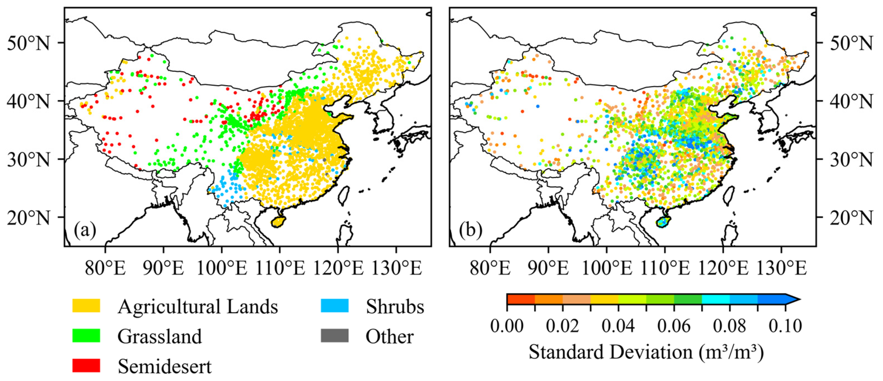
To objectively evaluate the performance of the soil moisture assimilation system, this study employed in situ soil moisture observations from ground-based stations that are temporally and spatially coincident with satellite overpasses as an independent validation benchmark. Hourly volumetric soil moisture measurements at the 0–10 cm depth layer from 2878 automatic soil moisture monitoring stations—operated by the National Meteorological Information Center (NMIC) of the China Meteorological Administration (CMA)—were used; soil moisture values extracted from these data served as quantitative references for validation. The spatial distribution of these stations is illustrated in Figure 1. Classification of the observation stations based on ERA5 vegetation types reveals that the underlying surface across China’s land domain is predominantly characterized by four types: agricultural land, grassland, semidesert, and shrubland (Figure 1a). To reveal the spatiotemporal discrepancies between in situ observations and CoLM simulations, the standard deviation of temporal errors between model-simulated and observed soil moisture was calculated at each station for July 2022. This metric quantifies the model’s capability to reproduce the temporal dynamics of observed soil moisture. Its spatial distribution is shown in Figure 1b. Statistical results grouped by vegetation type show that shrub stations exhibit the highest mean standard deviation (0.0541 m3/m3), followed by agricultural land stations (0.0521 m3/m3). Grassland and other vegetation types show moderate mean errors, while semidesert stations exhibit the lowest mean standard deviation (0.0314 m3/m3). These marked differences in simulation errors across vegetation types indicate that surface vegetation conditions significantly affect the CoLM’s ability to capture the temporal evolution of soil moisture. For systematic validation and analysis, this study primarily utilized observations from June to July 2022.

2.4. Data Preprocessing

To construct the input dataset for the assimilation system, this study conducted systematic preprocessing of multi-source data, including FY-3D/MWRI satellite brightness temperatures. First, land-based observations were extracted using the land mask provided by the FY-3D satellite (manufactured by China Aerospace Science and Technology Corporation, Beijing, China). Subsequently, rigorous geolocation quality control was performed: data from the five edge pixels of each scanning swath and all pixels within 50 km inland from land–water boundaries were excluded to mitigate edge effects and interference from mixed land–water pixels. Based on this, the nearest neighbor interpolation method was employed to match variables from the ERA5 reanalysis data—including 2 m air temperature, wind speed, liquid water content, and vegetation type—to the screened FY-3D observations. Furthermore, to eliminate the influence of clouds on surface microwave radiative transfer, the interpolated ERA5 cloud liquid water path (LWP) was used as a cloud detection indicator. Observations with LWP values exceeding 0.01 kg/m2 were identified as cloud-affected and excluded from the assimilation [45].
According to the design of the assimilation system, assimilation updates were performed at 00:00, 06:00, 12:00, and 18:00 UTC each day. To align with this scheme, input datasets within a 6 h window centered on each assimilation time were aggregated into a single analysis sample.

3. Model Description

3.1. The Common Land Model (CoLM)

Land surface process models provide a mathematical framework for simulating the physical exchanges of water and energy between the land surface and the atmosphere [46]. The Common Land Model (CoLM) adopted in this study is widely regarded as one of the most reliable and comprehensive land surface models [47,48]. The CoLM discretizes the soil column into multiple vertical layers, enabling high-resolution representation of soil moisture profiles. It explicitly represents key hydrological and biophysical processes—including precipitation infiltration, surface evaporation, vegetation transpiration, and surface and subsurface runoff. Furthermore, through an improved soil parameterization scheme that accounts for soil organic matter content, the CoLM refines the estimation of soil hydraulic and thermal properties, thereby improving the simulation fidelity.
The CoLM requires high-quality meteorological forcing data and static soil parameters for reliable operation. Meteorological forcing data are typically derived from atmospheric reanalysis products or in situ observations and include near-surface wind speed, 2 m air temperature, 2 m specific humidity, surface pressure, precipitation rate, and downward shortwave and longwave radiation [47,49]. In offline model evaluation, global reanalysis datasets—including ERA-Interim and ERA5—as well as high-resolution regional products such as the China Meteorological Forcing Dataset (CMFD) are commonly used as meteorological forcing [47,50]. Static soil parameters are drawn from global soil databases, notably the Global Soil Data Set for Earth System Modeling (GSDE) [51], to ensure the physical realism and cross-study comparability of simulations. In this study, the CoLM is forced exclusively by the ERA5 global atmospheric reanalysis dataset.
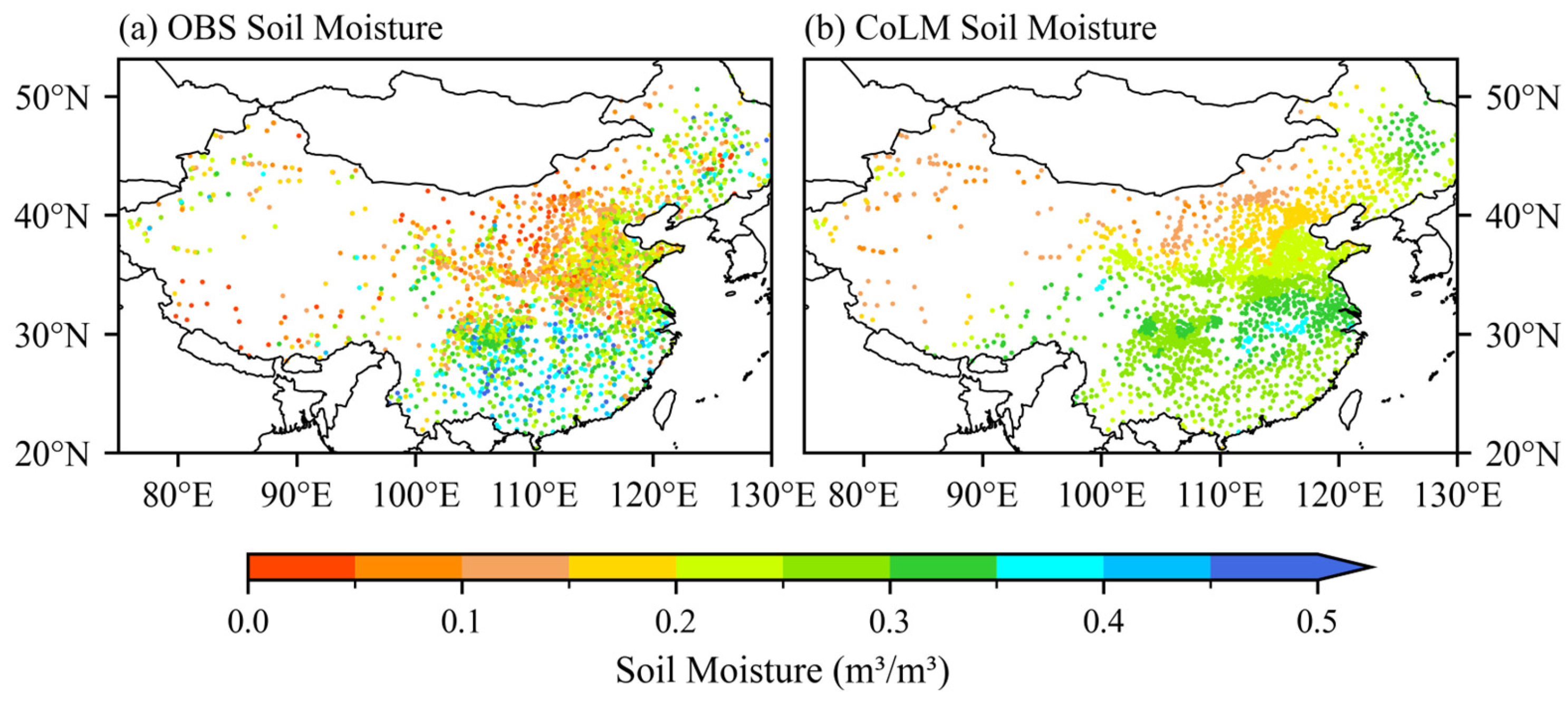
Figure 2 shows the 30-day average spatial distribution of volumetric soil moisture in the 0–10 cm soil layer, simulated by the Common Land Model (CoLM), compared with in situ observations from 2878 national meteorological stations. Observations reveal a spatial pattern characterized by “wet conditions in southern China and dry conditions in northern China, with wetter conditions in eastern regions and drier conditions in western regions”: soil moisture is generally high in southern regions such as the middle and lower reaches of the Yangtze River and South China (frequently exceeding 0.30 m3/m3), while northern regions such as western Inner Mongolia and Tibet are relatively dry (often below 0.15 m3/m3, with local areas below 0.05 m3/m3). The CoLM not only reproduces this wet–dry spatial pattern with reasonable fidelity but also captures the pronounced east–west gradient in soil moisture—from humid eastern regions to arid western regions—thereby demonstrating its capability to represent the large-scale spatial structure of soil moisture. However, localized biases persist in magnitude: simulated values are systematically higher in North China (115°E, 37°N) and the eastern Tibetan Plateau (94°E, 33°N), while underestimations occur at stations in East China (118°E, 30°N) and parts of South China (112°E, 25°N).

3.2. CMEM Radiative Transfer Model

This study employed the Community Microwave Emission Modeling platform (CMEM), a land surface microwave radiative transfer model developed under the leadership of the European Centre for Medium-Range Weather Forecasts (ECMWF), as the observation operator for comparative experiments [15]. The CMEM is specifically designed to simulate brightness temperature (TB) across the 1–20 GHz frequency range for diverse land surface conditions under varying polarization states (vertical/horizontal) and observation geometries (e.g., incidence angle, azimuth). As one of the most widely adopted and physically comprehensive radiative transfer models in soil moisture and land surface remote sensing, the CMEM explicitly represents radiative transfer processes over heterogeneous surfaces—including bare soil, vegetated canopies, snow, ice, and open water—while rigorously accounting for the coupled effects of atmospheric attenuation, sensor frequency, polarization, and viewing geometry on the simulated TB signal.
The CMEM employs a modular architecture that enables flexible selection of parameterization schemes for atmospheric contributions, soil emissivity, and vegetation emissivity. Given the focus of this study on summer season surface soil moisture, snow-related processes were explicitly disabled in the model configuration. The specific setup was as follows: (i) the Dobson dielectric mixing model [52,53] was applied to compute the complex dielectric constant of moist soil, consistent with the satellite observation frequency; (ii) the Fresnel reflectivity model [54] was used to derive surface emissivity under the assumption of a smooth, homogeneous interface; (iii) surface roughness effects were corrected using the semi-empirical Wegmueller model [55]; (iv) vegetation opacity was estimated via the geometric-optics-based Wegmueller model [56]; (v) atmospheric attenuation and emission were simulated using the Ulaby radiative transfer formulation [57]; and (vi) surface soil temperature was adopted as the effective physical temperature of the soil layer, while near-surface air temperature was used as a physically justified proxy for canopy temperature.

3.3. MLP Model

Uncertainty in land surface emissivity is a critical factor constraining the effectiveness of land surface radiance brightness temperature assimilation. Conventional observation operators, which heavily rely on this uncertain parameter, suffer from limited simulation accuracy. To overcome this dependency, Li et al. [44] developed an observation operator based on a Multilayer Perceptron (MLP) that achieves efficient and high-accuracy simulation of brightness temperature across different vegetation types without requiring explicit land surface emissivity.
The observation operator adopts a modeling strategy that groups vegetation types and distinguishes between daytime and nighttime conditions. Leveraging the strong nonlinear mapping capability of the MLP network, it learns the implicit physical relationships between brightness temperature and a suite of surface and environmental variables, such as surface temperature, wind speed, soil moisture, and satellite geometric parameters. This approach eliminates the explicit dependence on the surface emissivity parameter. Only the MLP submodel tailored to summer daytime conditions is used in subsequent experiments. The network consists of one input layer, three hidden layers and one output layer. The number of neurons in the three hidden layers is set to 100, 100, and 50. All hidden layers employ the Rectified Linear Unit (ReLU) as the activation function. The model incorporates ten input variables, including surface thermal and moisture conditions, near-surface wind fields, and satellite and solar geometric parameters; a detailed list is shown in Table 2. All input features are normalized using the mean–standard deviation method. During model training, the mean squared error (MSE) is used as the loss function, and the stochastic gradient descent (SGD) optimizer is adopted for training. After training, the network weights achieving the minimum error on the validation set were selected as the final model. Training samples were taken from July to August 2022. The dataset was randomly split into training and validation sets at a ratio of 7:3. Data from June 2022 were used solely for independent model testing and were not involved in model training or parameter tuning.
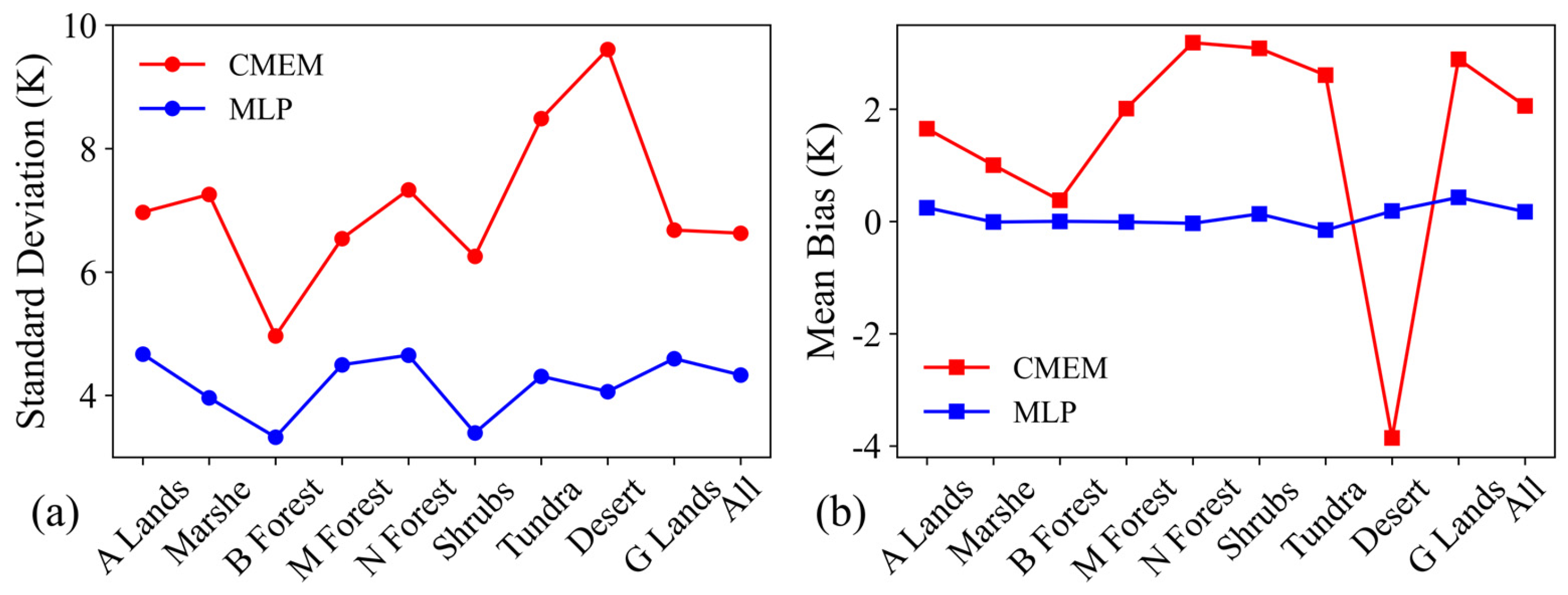
Brightness temperature simulation evaluations for the FY-3D/MWRI 10.65 GHz vertically polarized channel using samples from July to August 2022 indicate that the MLP model achieves remarkably better simulation accuracy than the conventional CMEM under daytime conditions for most vegetation types (Figure 3). The overall standard deviation decreases from 6.63 to 4.33 K, and the mean bias reduces from 2.06 to 0.17 K. Obvious improvements are also found over semidesert, where traditional models suffer the largest errors due to high sensitivity to surface emissivity; the standard deviation drops from 9.60 to 4.06 K, and the mean bias changes from −3.86 to 0.18 K. Furthermore, the mean biases of the two models under different vegetation types are adopted as respective bias correction coefficients in subsequent experiments.

3.4. SEKF Assimilation Method

The Simplified Extended Kalman Filter (SEKF) is a computationally efficient variant of the linearized Extended Kalman Filter (EKF) that links observations to prognostic variables via the observation operator H, thereby supporting point-wise data assimilation [58,59,60]. The state variable update is formulated as follows:
x a = x b + K [ y o H ( x b ) ]
where x denotes the state variable; x a and x b represent the analysis and background fields, respectively; y o is the observation vector; H is the nonlinear observation operator mapping state variables from model space to observation space; and H ( x b ) represents the simulated observation vector. The Kalman gain matrix K weights the contributions of model state and observations:
K = B H T ( H B H T + R ) 1
where H is the Jacobian matrix of the observation operator and HT its transpose; B and R denote the background and observation error covariance matrices, respectively, quantifying their respective uncertainties. The Jacobian matrix H reflects the sensitivity of brightness temperature to infinitesimal perturbations in soil moisture within the top three soil layers. In this study, H is computed numerically using the finite difference method:
H = H ( x + δ x ) H ( x ) δ x
That is, H is derived by applying an infinitesimal perturbation δx to the soil moisture in the background state vector and computing the resulting change in simulated brightness temperature via the observation operator.

3.5. Land Surface Data Assimilation System

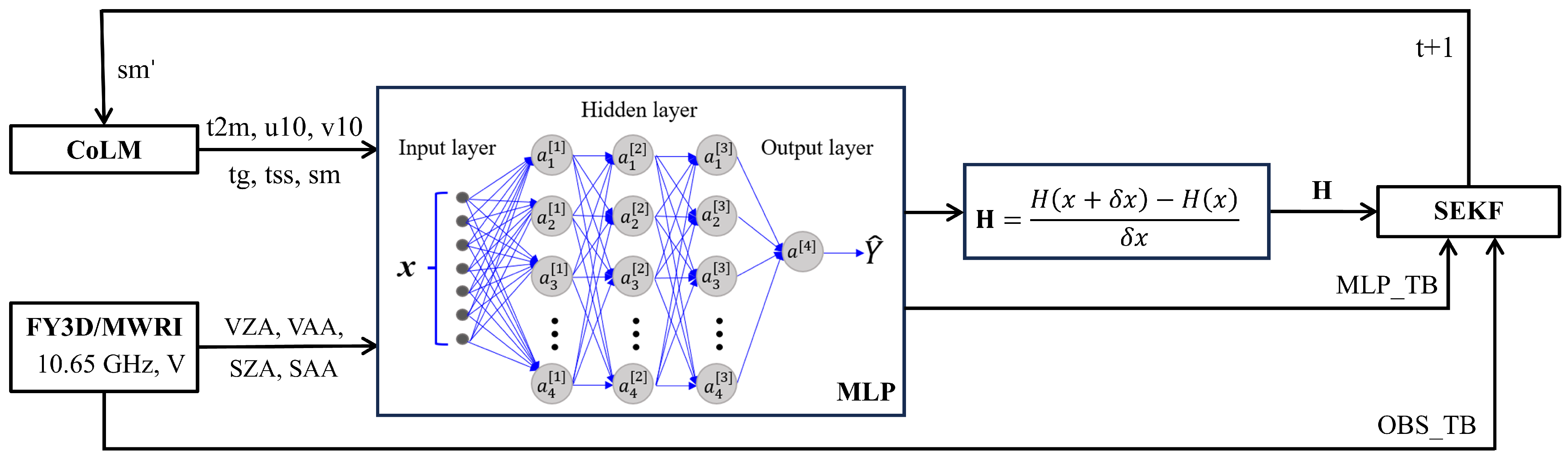
Built upon the CoLM and SEKF assimilation framework, this study implemented two land surface data assimilation systems: one employing the MLP observation operator and the other the CMEM observation operator (hereafter referred to as the MLP and CMEM schemes, respectively). Both systems use CoLM-simulated fields as the background state and assimilate satellite observations via the SEKF to update soil moisture. The technical framework of the assimilation system based on the MLP model is illustrated in Figure 4.
During the assimilation process, model-simulated soil moisture is first interpolated to satellite observation points. The difference between observed and simulated brightness temperatures is then calculated to derive the observation increment. Subsequently, a regional averaging method is used to re-interpolate this increment field back to the model grid; for example, for each model grid cell as the center, all observation points within a range of twice the grid spacing are searched, and the arithmetic mean of their observation increments is computed for assimilation updates. This method effectively reduces errors introduced by directly interpolating observed brightness temperatures to the model grid and better preserves the original observation information.

4. Numerical Experiments

4.1. Sensitivity Test of Observation Operator

In SEKF assimilation systems, it is necessary to define the adjoint matrix of the observation operator, which is usually obtained by transposing the observation operator matrix. Therefore, the observation operator matrix must be computed first. The observation operator is a nonlinear function, and its matrix representation can only capture its linearized component. Here, the linearized operator matrix is typically obtained via perturbation experiments involving two perturbed versions of the observation operator [5]. The experiment uses the model simulation output at 06:00 UTC on 2 June 2022 as the reference state (denoted as x b ) and applies a suite of small, symmetric positive and negative perturbations—ranging in amplitude from 10 7 to 10 2 —to the soil moisture variable, thereby generating the corresponding perturbed states x b + and x b . After inputting these states into the CMEM and MLP surrogate model, the reference brightness temperature, the positively perturbed brightness temperature T B p e r t + , and the negatively perturbed brightness temperature T B p e r t are obtained for each model. Based on these results, the forward difference H + and the backward difference H of this observation operator are computed as approximations of the following tangent–linear operator:
H + = [ T B p e r t + T B n o ] / p e r t
H = [ T B p e r t T B n o ] / p e r t
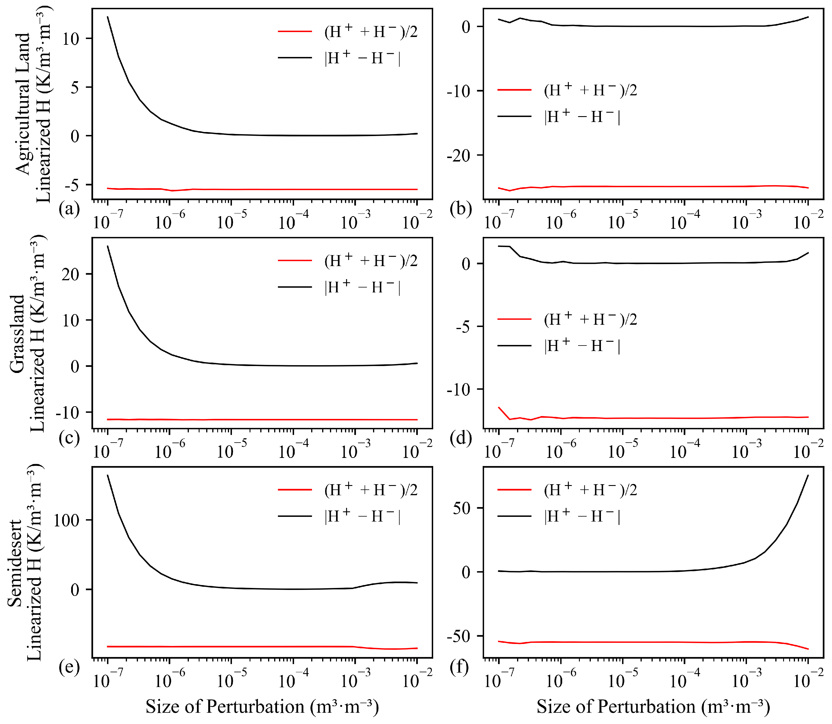
where H + quantifies the output change rate of the observation operator after applying a positive perturbation to the background state, and H measures that after applying a negative perturbation; p e r t denotes the imposed perturbation magnitude. Mathematically, H + and H are numerical approximations of the tangent–linear operator (i.e., the Jacobian matrix) of the observation operator in the reference state. If the MLP model is continuously differentiable in a neighborhood of the reference state, then its response gradients to perturbations along distinct directions must be consistent; this consistency implies that H + and H are nearly identical. Stability is assessed against two core criteria: first, as the perturbation magnitude decreases, H + H should approach 0, indicating differentiability, while ( H + + H ) / 2 should converge to a stable value, ensuring a reliable tangent–linear approximation [5].
Figure 5 shows the sensitivity responses of the two observation operators to three typical underlying surfaces: agricultural land, grassland, and semidesert. The red and black solid lines correspond, respectively, to the curves of the mean ( H + + H ) / 2 and absolute difference H + H , serving as functions of perturbation magnitude (the same convention applies throughout). Figure 5 shows that the perturbation responses of the CMEM exhibit relatively consistent piecewise characteristics across the different underlying surfaces. At the minimal perturbation magnitude ( 10 7 ), the asymmetry curves all show high initial values, rapidly decay as the perturbation increases, and then quickly approach 0. Within the range of 10 6 to 10 2 , the asymmetry and corresponding mean values of the CMEM remain stable, with no noticeable increase as perturbation magnitude grows. Among the three surfaces, semidesert exhibits significantly higher asymmetric response intensity under small perturbations than agricultural land or grassland, indicating the most pronounced nonlinear behavior; in contrast, the response curves for agricultural land and grassland are flatter, reflecting higher overall stability compared with semidesert. Moreover, the mean response (red solid line) for semidesert is significantly higher than that of the other two surface types and attains the highest response intensity overall. For the MLP observation operator, stability is well maintained over the moderate-perturbation interval: within the magnitude range 10 6 to 10 3 , H + H approaches zero and ( H + + H ) / 2 converges to a stable value, satisfying the stability criterion [5]. When the perturbation exceeds 10 3 , nonlinear effects become markedly enhanced; when it is too small (e.g., less than 10 6 ), numerical roundoff errors may dominate. Across the full perturbation range, agricultural land and grassland demonstrate relatively strong overall stability, with minimal variation in their central response values; agricultural land also maintains stability under moderate and small perturbations, with only a sharp rise in sensitivity observed under strong disturbances. Semidesert displays the highest perturbation sensitivity among the three surface types, showing the most significant asymmetric response intensity, yet the values are still substantially lower than the corresponding values for the CMEM.
Based on the above sensitivity analysis results, this study determined the optimal perturbation magnitude ranges for the two observation operators tailored to each vegetation type. For the CMEM, the perturbation magnitude was set to 10 3 for agricultural land and grassland (with good overall stability), and for semidesert, it was set to 10 4 (more sensitive to perturbations). For the MLP observation operator, the perturbation magnitude was set to 10 4 for agricultural land and grassland, where stability is maintained over the moderate-perturbation interval; for semidesert, it was set to 10 5 , as this surface type exhibits the strongest perturbation sensitivity among the three and responds with pronounced nonlinear behavior under large perturbations.

4.2. Error Setting

Specifying the observation and background error covariance matrices is a core step governing the quality of the analysis field in a data assimilation system. The observation error covariance matrix R quantifies the uncertainty inherent in observational data, whereas the background error covariance matrix B characterizes the uncertainty associated with the model forecast state.
To objectively and quantitatively assess the error characteristics of the two observation operators, this study conducted systematic statistical validation of the biases between satellite-observed brightness temperatures and those simulated by the MLP model and the CMEM—separately for each vegetation type. The results indicate that model errors varied across different vegetation types. To accurately reflect the total observational uncertainty under various scenarios, it is necessary to set observation errors separately for each vegetation type. Accounting for the combined contributions of instrumental noise, forward model approximation errors, and other unquantified sources, the MLP model’s observation errors were set to values slightly exceeding the standard deviation of the corresponding vegetation type-specific bias (Table 3), thereby ensuring robust representation of observational uncertainty under diverse vegetation conditions. In contrast, the CMEM employed a uniform observation error of 8 K—chosen to be marginally larger than the overall bias standard deviation—to facilitate direct comparison.
Meanwhile, this study used the CoLM-simulated soil moisture from the top three layers as the background state for assimilation. Based on the statistical characteristics of historical CoLM simulations, the background error standard deviations were set to 0.17 m3/m3 for the first layer and 0.16 m3/m3 for the second and third layers. These background errors reflect the long-term bias in soil moisture from the free-run CoLM simulations. In this study, free-run outputs of the CoLM from July to August 2022 were used, with ERA5 reanalysis soil moisture data serving as the reference. The root mean square error (RMSE) between model simulations and ERA5 datasets was calculated for each grid cell. Subsequently, the RMSE values for all grids within the same vegetation type were averaged, yielding the vegetation-dependent background errors for each soil layer. To ensure a fair performance comparison between the MLP and CMEM assimilation systems, identical background states and background error specifications were applied to both systems.

4.3. Quality Control

To ensure the reliability of assimilation system inputs, this study implemented an additional quality control step on the simulated brightness temperature data, building upon preliminary systematic preprocessing. The preliminary preprocessing had already removed contamination from observational edge effects, sea–land mixed pixels, and cloud-affected observations—achieved through geographic positioning screening, sea–land boundary masking, and cloud detection. Subsequently, a threshold-based outlier detection method was applied: samples for which the absolute observation increment (i.e., the difference between observed and background-simulated brightness temperatures) exceeded twice the standard deviation of all increments were flagged as outliers and excluded. This step effectively removed highly biased or high-variance samples that could otherwise degrade assimilation performance, thereby yielding a higher-quality observational dataset for assimilation.
The same unified quality control procedure was applied to the MLP and CMEM assimilation systems to ensure consistent input data quality across experiments.

4.4. Experimental Design

The assimilation period spanned from 00:00 UTC on 2 June 2022 to 00:00 UTC on 2 July 2022, with assimilation cycles executed every 6 h—yielding a total of 120 analysis times. Following this, one-week forecast experiments covering the period 2–9 July 2022 were conducted. Using soil moisture from the top three CoLM layers as the background state, the assimilation system first mapped it to radiometric brightness temperature via the respective observation operator, then fused satellite-observed brightness temperatures using the SEKF to achieve layer-resolved soil moisture updates. Assimilation updates were only conducted at times with valid FY-3D satellite observations. During periods without satellite observations, only forward model integration was carried out, and no observational constraints were applied.
Three comparative experiments were conducted (Table 4): (1) the control experiment (CTL), in which no data assimilation was performed, and the CoLM ran freely; (2) the MLP assimilation experiment, employing the MLP observation operator; and (3) the CMEM assimilation experiment, which substituted the CMEM observation operator for MLP while retaining all other assimilation configurations—including background state, error specifications, quality control, and SEKF settings—identical to those in the MLP experiment.

5. Analysis of Numerical Results

5.1. Analysis of Assimilation Improvement Effects

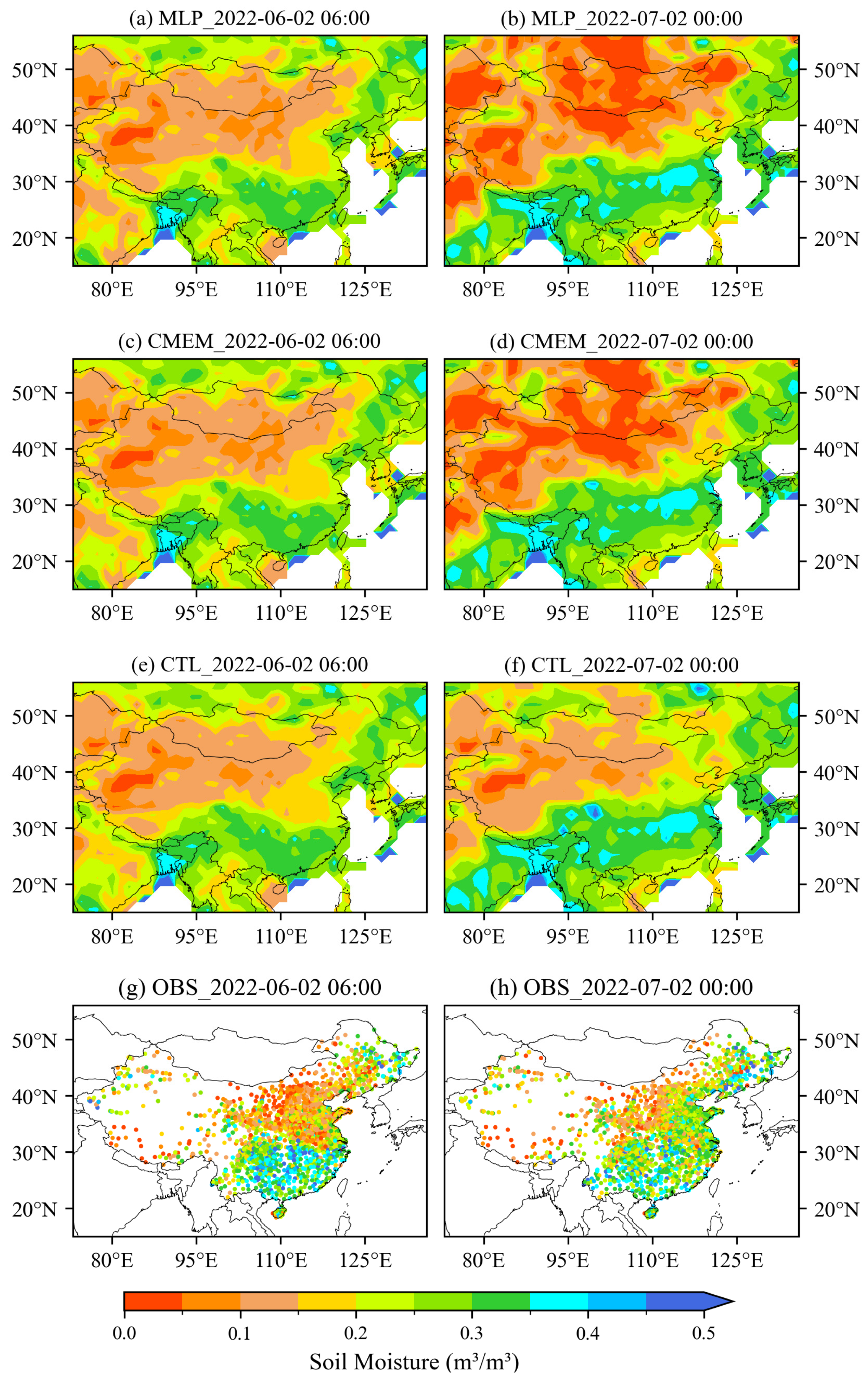
Figure 6 shows the spatial distribution of the top three layers’ average soil moisture at the beginning and end of the assimilation period for the three experimental groups (CTL, MLP, and CMEM) and the station observations. At the start of the assimilation period, observed soil moisture exhibits a distinct spatial gradient, with higher values in the southeast and lower values in the northwest. The Northeast Plain (127°E, 45°N) and southern regions (113°E, 27°N) are the main wet centers, with maximum volumetric soil moisture exceeding 0.4 m3/m3; the Tibetan Plateau (85°E, 32°N), Inner Mongolia Plateau (110°E, 41°N), Loess Plateau (107°E, 37°N), and the northern part of the North China Plain (117°E, 39°N) constitute extensive dry centers, with soil moisture generally below 0.15 m3/m3 and the driest areas on the Tibetan Plateau and Inner Mongolia Plateau even falling below 0.05 m3/m3. All three experimental groups reproduce the spatial locations of the main wet and dry areas, with deviations only in magnitude: for dry areas such as the Inner Mongolia Plateau, the simulated results are significantly higher than the actual observations; for wet areas such as the Northeast Plain, the simulated results are notably lower than the observed values, overall exhibiting a characteristic of “wetter in dry areas and drier in wet areas”.
At the end of the assimilation period, the spatial pattern of the observed values still maintains the overall distribution characteristics of wet southeast and dry northwest, but the specific structure has undergone significant adjustments: the extent of dry areas in the northern region has substantially reduced and contracted northward, with northern North China transitioning from dry to wet; the extent of the wet center in the Northeast Plain has increased, and its intensity has strengthened, while the humidity in the main wet areas of the south has weakened compared with the initial state. Compared with the CTL experiment, both assimilation experiments significantly improve the simulation of soil moisture spatial structure. In dry regions—including the Inner Mongolia Plateau and the Loess Plateau—the spatial extents simulated by all three experiments broadly agree with observations. However, the assimilation experiments better capture drought intensity: simulated values are consistently below 0.10 m3/m3, with local minima dropping below 0.05 m3/m3, whereas CTL overestimates soil moisture, yielding values predominantly between 0.10 and 0.20 m3/m3. In the humid Northeast Plain, both assimilation experiments successfully reproduce the spatial structure of the wet center.
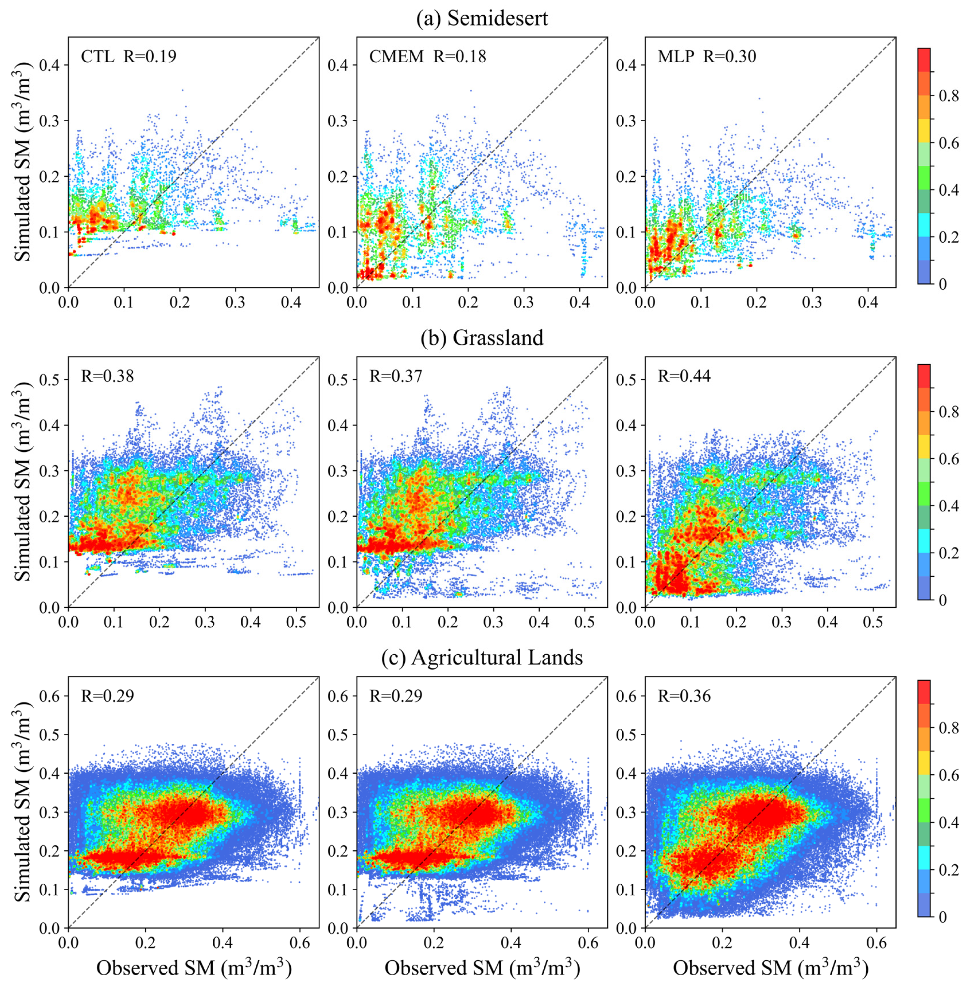
To further quantitatively evaluate the performance of assimilation schemes adopting different observation operators over diverse underlying surfaces, scatter plots comparing simulated soil moisture from three experiments with in situ station observations are displayed for three vegetation types with abundant samples (Figure 7). The figure shows that although certain errors exist in simulated soil moisture under all three vegetation types, the CTL experiment shows evident positive bias, especially in regions with low observed soil moisture. In comparison, the CMEM experiment can reduce the positive bias to some extent over semidesert areas, while its improvement effect is obviously weak for grassland and agricultural lands. The MLP assimilation experiment delivers distinct improvements in soil moisture simulations for all vegetation types. Assimilated soil moisture achieves better consistency with observations, which is more pronounced under conditions where soil moisture is less than 0.2 m3/m3, and the overall correlation coefficients are higher than those of the CTL and CMEM assimilation experiments.

5.2. Evaluation of Assimilation Improvement Effects Using MLP

To evaluate the effectiveness of the MLP-based assimilation system, this study compares the MLP experiment (with assimilation) against the CTL experiment (without assimilation). Soil moisture outputs from all experiments are vertically integrated into an equivalent 0 to 10 cm layer via thickness-weighted averaging to facilitate direct comparison against in situ station observations.
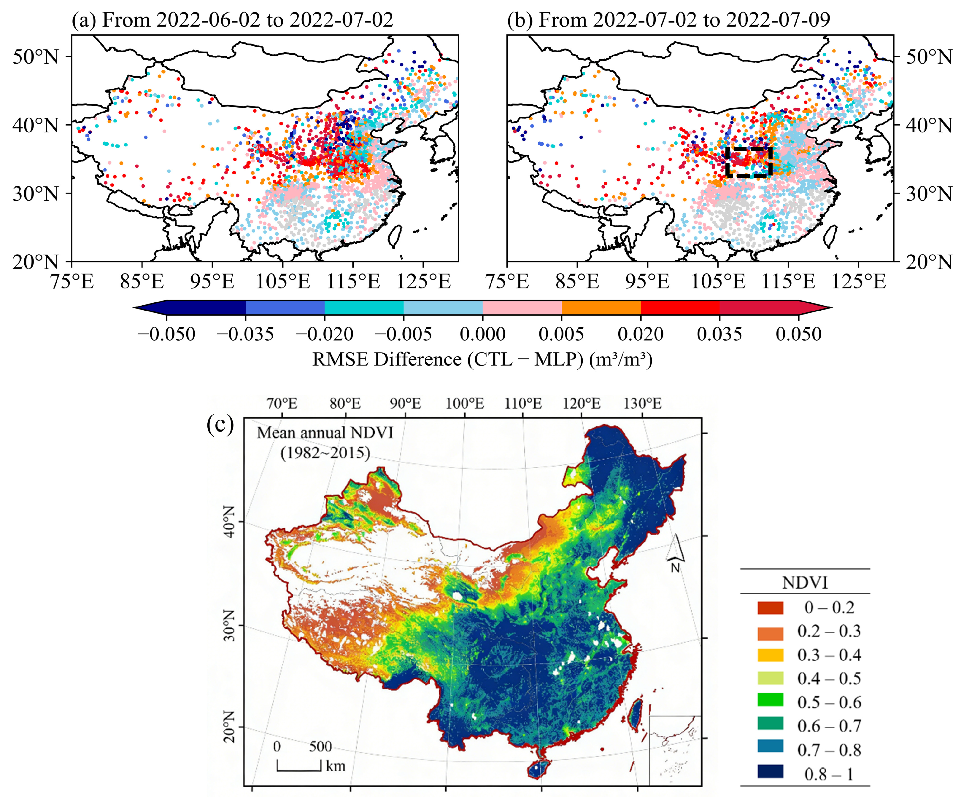
Figure 8a shows the spatial distribution of RMSE differences (CTL minus MLP) for surface soil moisture during the assimilation period. Across most regions, the differences are positive, indicating that the assimilation system effectively reduced simulation errors over most regions. Areas with significant error reduction (i.e., positive RMSE differences) are mainly concentrated in the Tibetan Plateau (92°E, 32°N), Loess Plateau (107°E, 37°N), Henan Province (113°E, 33°N), and northern Anhui Province (116°E, 31°N). Among the evaluated regions, the Loess Plateau shows the most pronounced improvement: the RMSE in the MLP experiment decreases by more than 0.04 m3/m3 relative to CTL. In contrast, improvements are marginal in the Northeast Plain, North China, and South China, which may be related to regional vegetation coverage. To clarify the causes of these differences, Figure 8c presents the spatial distribution of the annual mean Normalized Difference Vegetation Index (NDVI) over China [61,62], with vegetation coverage classified into five categories: low [0, 0.2), moderately low [0.2, 0.4), moderate [0.4, 0.6), moderately high [0.6, 0.8), and high [0.8, 1]. Regions such as Northeast and Southeast China are predominantly characterized by high vegetation coverage, while the Inner Mongolia Plateau and Loess Plateau are mainly covered by moderately low vegetation, and areas such as the Taklamakan Desert and western Tibetan Plateau exhibit low vegetation coverage [45,46]. In the Loess Plateau and surrounding areas such as Henan, vegetation is relatively sparse, leading to a stronger direct sensitivity of brightness temperature to soil moisture and reduced microwave signal attenuation by the vegetation layer. Consequently, the assimilation system more effectively exploits observational information to correct the model state. In contrast, regions including Northeast China and the southeastern coastal areas are predominantly covered by dense forests in summer, where abundant vegetation enhances vegetation emission and diminishes the direct sensitivity of brightness temperature to soil moisture, thereby limiting the assimilation system’s ability to optimize soil moisture estimates.
To assess the persistence of assimilation effects, a one-week forecast evaluation was conducted immediately after the assimilation period (2–9 July 2022) (Table 3). Figure 8b shows the spatial distribution of RMSE differences in surface soil moisture between the two experimental groups during the forecast period. The results indicate that the positive impact of assimilation attenuates in spatial extent and magnitude; however, the Loess Plateau, which exhibited the largest assimilation improvement, still maintains a statistically significant advantage. One week after assimilation ceased, the RMSE in the MLP experiment over this region was still more than 0.02 m3/m3 lower than that in the CTL experiment, indicating robust persistence of the assimilation benefit. Furthermore, the negative assimilation impacts observed in North China and South China were also alleviated. These spatial differences are closely linked to underlying surface vegetation and land surface conditions. In the Loess Plateau, where vegetation is sparse, soil moisture dynamics are dominated by slow physical processes such as evaporation, leading to low temporal variability and enabling the assimilated state to persist more effectively during the forecast period. In contrast, in regions such as South China, where vegetation is abundant, active energy and water exchange between vegetation and the atmosphere continuously modulates soil moisture, thereby diminishing the persistence of assimilation effects. Thus, the vegetation characteristics and land surface conditions of the underlying surface determine not only the magnitude of assimilation improvement during the analysis phase but also the persistence of its benefits during the forecast phase.
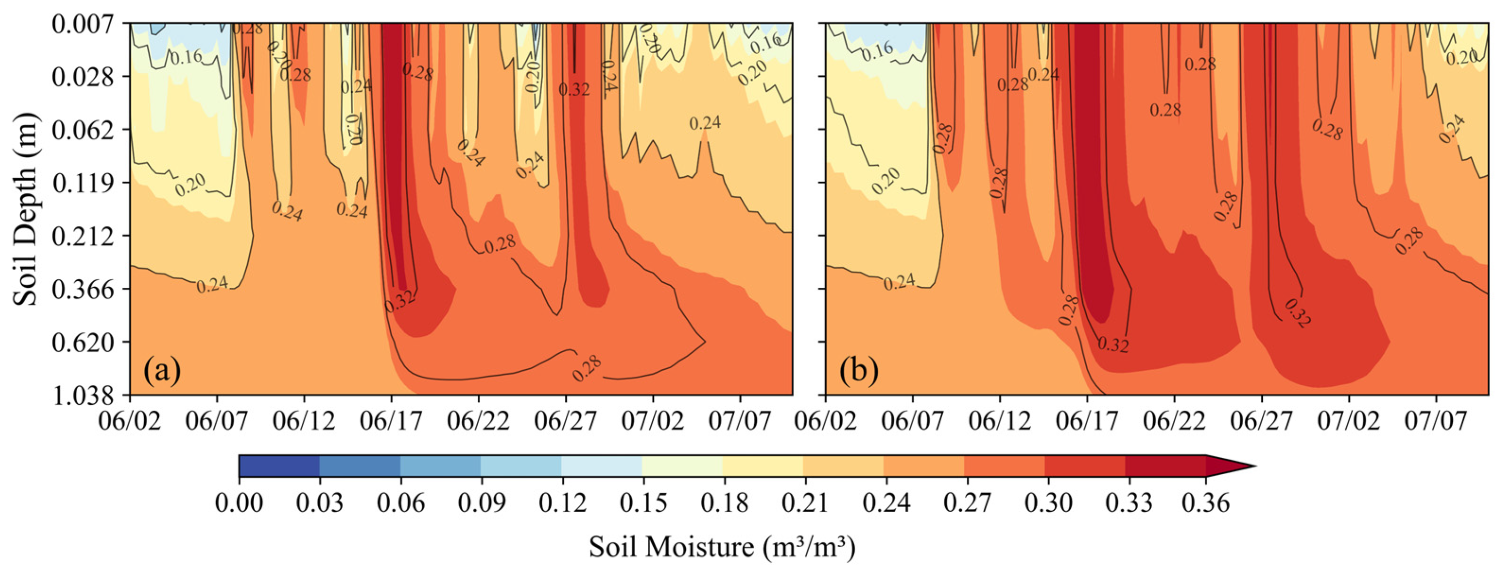
Figure 9 displays the vertical cross-sections of soil moisture from the two experiments (CTL and MLP) over the region 32–35°N, 106–110°E. The figure shows two distinct events of significant surface soil moisture increase occurred in this region around 17 June and 27 June. The moistening signals propagated rapidly downward to soil layers above 30 cm as the model integrated, gradually extending their influence to deeper layers. Continuous land surface assimilation exerted an overall reducing effect on soil moisture in this region: in the CTL experiment (Figure 9b), the elevated soil moisture persisted and continued to affect the region, whereas in the MLP experiment (Figure 9a), the assimilation quickly introduced moisture adjustment information into the surface layer, effectively weakening the impact of the two surface moistening events on deep soil. Notably, this assimilation effect remained evident in the simulation of deep soil moisture after 1 July. While this analysis confirms the capacity of land surface assimilation to adjust deep soil moisture, the validity of the assimilation effects requires further verification with actual observational data in subsequent studies.

5.3. Comparison of Performance Between MLP and CMEM Observation Operators

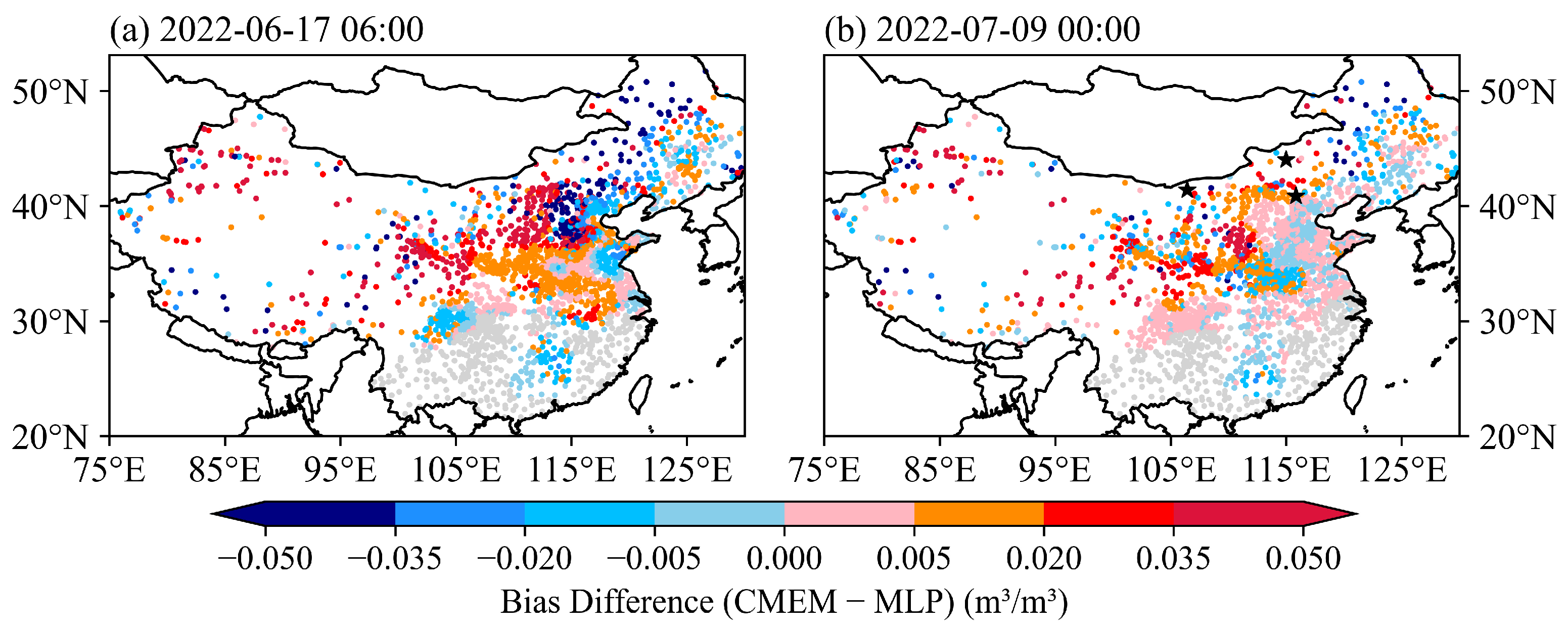
Figure 10 presents the spatial distribution of the difference in absolute simulation error between the CMEM and MLP experiments (CMEM−MLP) at 06:00 on 17 June 2022 during the assimilation phase (Figure 10a) and 00:00 on 9 July 2022 during the forecast phase (Figure 10b). During the assimilation phase (Figure 10a), the MLP scheme exhibits obvious advantages, with the averaged difference in simulation error reaching 0.0042 m3/m3. The fraction of areas where MLP performs better (stations with smaller simulation errors for MLP) accounts for 52%, notably higher than that for the CMEM (33%). This demonstrates that the MLP model achieves comparable performance to the well-established physical model in assimilating observational information. Spatially, regions with prominent improvements in the MLP experiment (positive error differences) are mainly distributed across most of Xinjiang, eastern Qinghai, northern Sichuan, the Loess Plateau, Henan, and Anhui. These areas feature relatively sparse vegetation coverage, and soil moisture responds sensitively and directly to variations in microwave brightness temperature. Since the MLP model avoids physical parameterization of surface emissivity, it eliminates errors originating from the uncertainty of emissivity estimation in the CMEM. In contrast, the MLP and CMEM experiments deliver generally similar performance over the southern North China Plain and southeastern China, largely owing to diverse and dense vegetation that induces strong emission and attenuation of microwave signals.
During the forecast phase (Figure 10b), the robustness advantage of the MLP scheme becomes more pronounced, with the proportion of regions where MLP performs better expanding to 56%, while the proportion where the CMEM outperforms MLP decreases to 29%. The regions where the MLP experiment continues to show improvement remain concentrated in areas with relatively simple underlying surface structures, such as the Loess Plateau and central Xinjiang, where the response of soil moisture to microwave signals is relatively stable, allowing the assimilation impact to maintain good persistence.

6. Analysis of Temporal Variations in Assimilation Impact

6.1. Case Analysis of Soil Moisture Stations

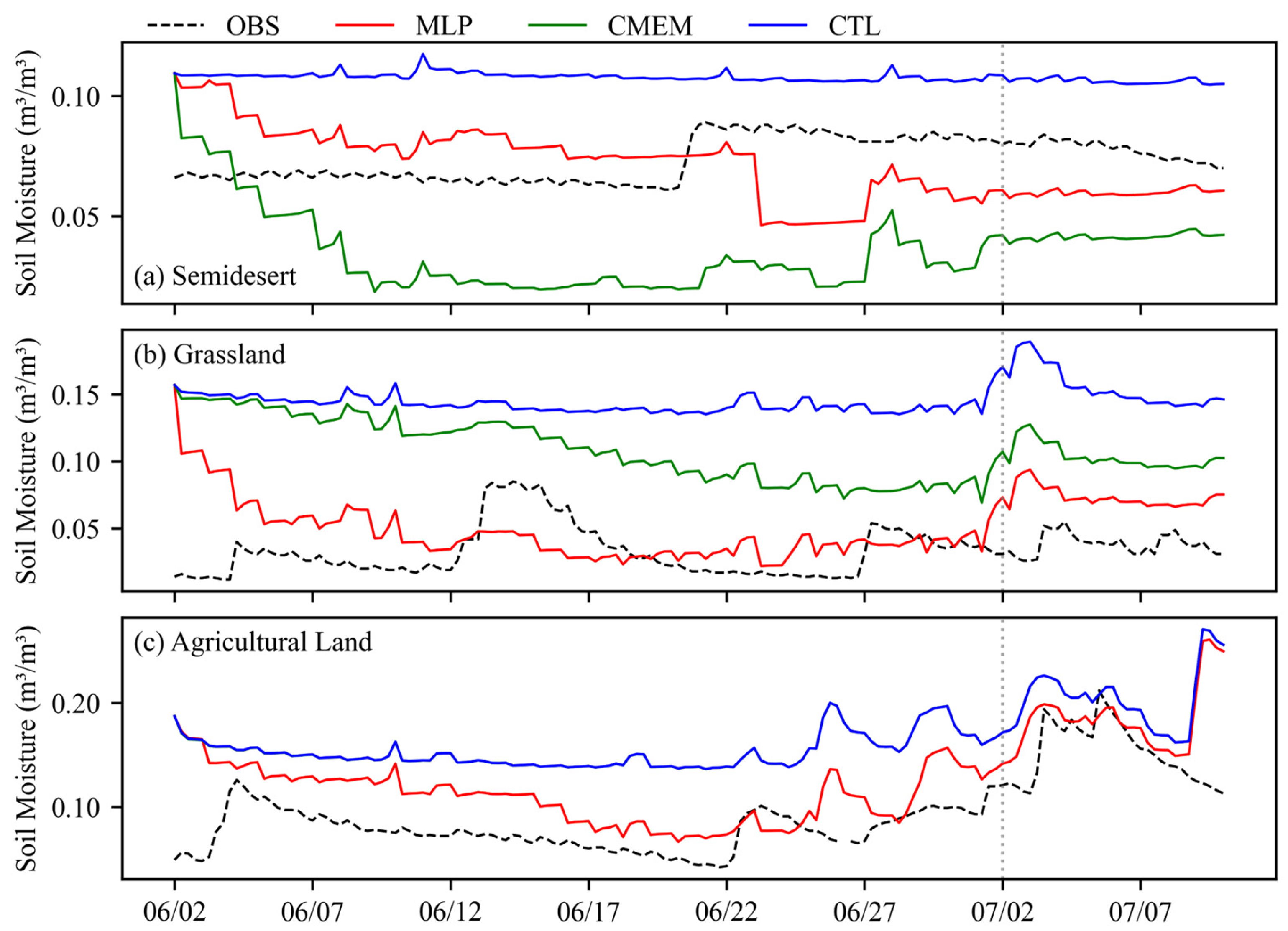
To systematically examine how assimilation effects vary with underlying surface types, three representative stations located on semidesert, grassland, and agricultural land (geographical locations shown in Figure 10b) were selected for case studies. Time series of observed and simulated soil moisture at each station are presented in Figure 11. Initially, the model-simulated soil moisture in all three experiments exhibited a wet bias relative to observations. In the CTL experiment, this bias persisted throughout the simulation period due to the absence of observational constraints, resulting in poor representation of temporal soil moisture dynamics. In contrast, after assimilation, the responses of the two experimental groups differed significantly across underlying surfaces.
At the semidesert station (Figure 11a), the initial soil moisture exhibited a wet bias of approximately 0.05 m3/m3 relative to observations. In the CMEM assimilation experiment, this bias was corrected within two days, achieving the closest agreement with observed values first. This indicates a rapid response to strong brightness temperature signals under dry surface conditions. However, the system then continuously over-adjusted, causing soil moisture to remain persistently below the observations and form a stable dry bias with an average deviation of −0.03 m3/m3. This may be attributed to limited temporal responsiveness of the CMEM to soil moisture changes, for example, the land surface emissivity model’s insensitivity to small soil moisture variations. In contrast, the MLP assimilation experiment initially adjusted more slowly but gradually converged toward the observed values during the second week of assimilation and subsequently fluctuated narrowly around the observations, maintaining a state closest to the observations even during the subsequent forecast period, thereby demonstrating superior long-term stability and adaptability.
Figure 11b presents the results for the grassland site with relatively slow soil moisture changes. The initial soil moisture at this site showed a wet bias of approximately 0.14 m3/m3 relative to observations. Although the CMEM assimilation experiment slowly approached the observations, its adjustment magnitude was limited, and it ultimately failed to effectively correct the model’s inherent wet bias. In contrast, the MLP assimilation experiment gradually adjusted to near the observed values within about one week, and then maintained stability while responding to short-term observational variations. This indicates that the statistical model retains a certain capacity for soil moisture information extraction and assimilation even under vegetation influence.
Figure 11c presents the results for the agricultural land site with denser vegetation. The initial wet bias at this site was approximately 0.15 m3/m3 relative to observations. The CMEM assimilation experiment performed highly similarly to the control experiment at this site (blue and green lines overlapping), indicating weak assimilation influence and failure to correct the model’s wet bias. In contrast, after adjusting to near the observed values, the MLP assimilation experiment fluctuated more stably around the observations without systematic deviation. It also maintained assimilation influence for approximately one week during the subsequent forecast phase, demonstrating better state retention and adaptability.

6.2. Analysis of Mean Error Characteristics

Previous studies have shown that due to the complex underlying surface environment in high-altitude regions (e.g., the Tibetan Plateau) and the significant errors in the background field data used to train the MLP model in such areas, the MLP model exhibits noticeable biases and suboptimal performance in brightness temperature simulations [37]. To ensure the reliability and representativeness of quantitative statistical results and to avoid interference from systematic errors in high-altitude regions on the overall assessment, only stations east of 100°E were selected for the analysis in this section, enabling an objective comparison of the performance differences between the MLP assimilation scheme, the CMEM assimilation scheme, and the control experiment (CTL) in soil moisture simulation.
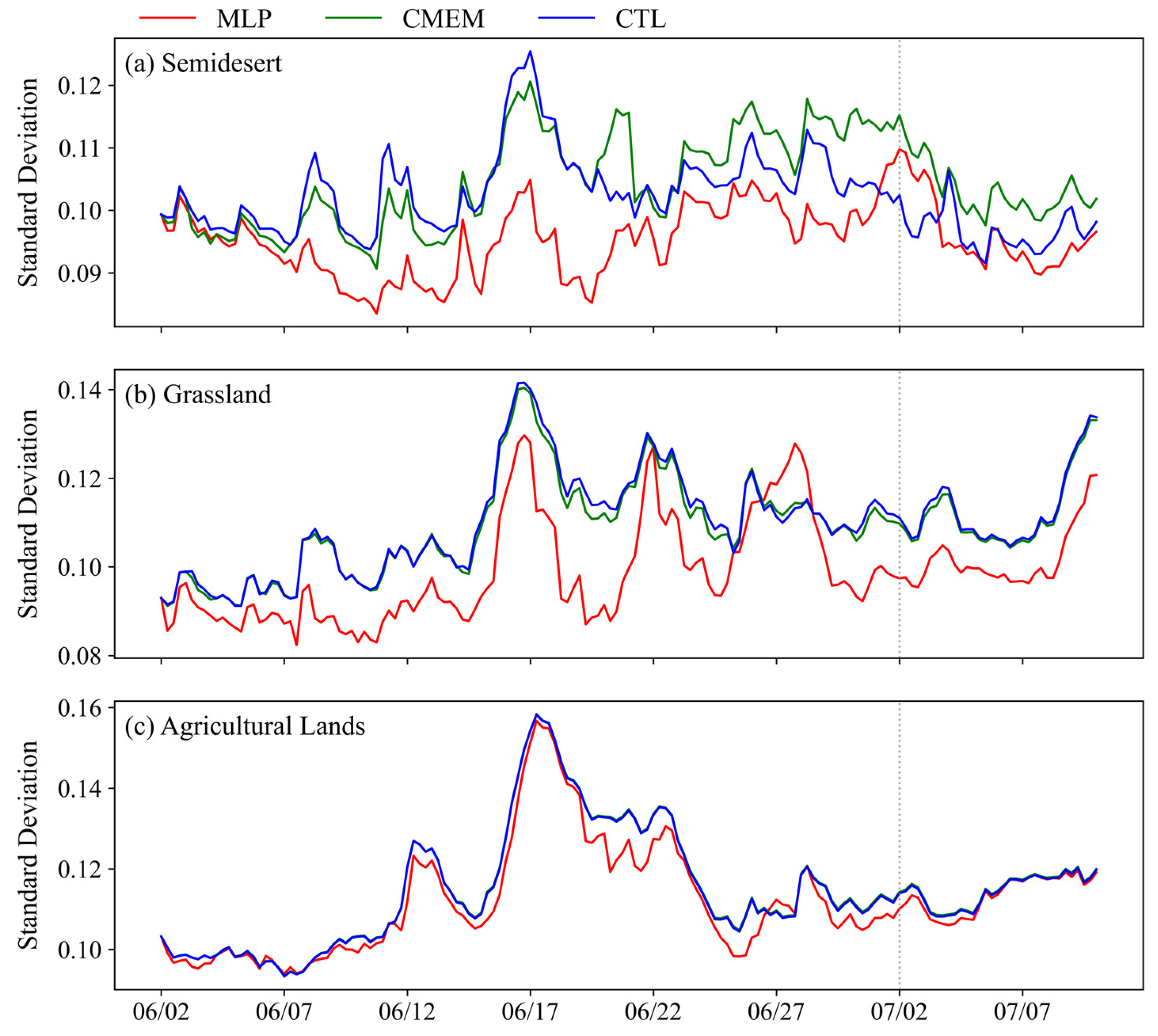
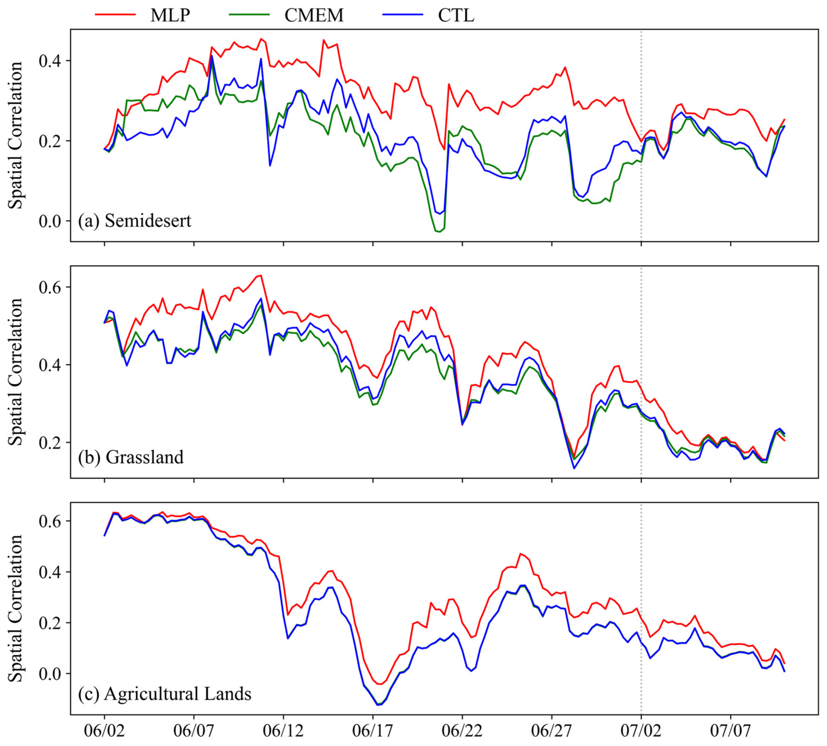
Figure 12 and Figure 13 show the temporal evolution of the standard deviation and correlation coefficient, respectively, for soil moisture from the MLP assimilation experiment, CMEM assimilation experiment, and CTL experiment, all evaluated against observations under the three vegetation cover conditions described above. Land surface assimilation yielded the greatest improvement in semidesert regions (Figure 12a and Figure 13a). The CTL experiment maintained a relatively steady standard deviation within 0.1 to 0.13 m3/m3. In the CMEM experiment, the improvement effect was relatively obvious at the initial stage of assimilation, with the standard deviation and correlation coefficient being better than those of the CTL experiment. However, this improvement gradually diminished as assimilation progressed, likely due to increasing background field accuracy, which reduces the relative benefit of assimilation. In contrast, MLP consistently achieved a lower standard deviation and higher correlation coefficient than CTL throughout assimilation and into the forecast period. This may be attributed to the fact that land surface emissivity in semidesert areas is highly susceptible to factors such as soil texture, surface roughness, and instantaneous water content, leading to substantial fluctuations and making errors difficult to control in the CMEM, thereby preventing the assimilation advantage from being sustained or even manifested. The MLP model, however, does not require land surface emissivity as input, and thus avoids error propagation from these sources entirely. Consequently, in semidesert regions, MLP-simulated soil moisture values demonstrate significantly better stability and spatial correlation than the CMEM assimilation experiment and CTL experiment, representing the most prominent improvement.
Compared with semidesert stations, the underlying surfaces at grassland and agricultural land stations are more heterogeneous. At grassland stations (Figure 12b and Figure 13b), overall dispersion was marginally higher than at semidesert stations. The CMEM experiment reduced the standard deviation relative to the CTL only sporadically—primarily during early assimilation—and showed negligible improvement in spatial structure, as indicated by the correlation coefficient. In contrast, the MLP experiment sustained a consistently lower standard deviation than the CTL and CMEM throughout the assimilation period; its correlation coefficient remained the highest across all time steps, and the assimilation-induced improvement persisted for approximately five days into the forecast period. Cropland stations (Figure 12c and Figure 13c) feature the most heterogeneous underlying surfaces. Here, the CTL experiment exhibited the largest dispersion and strongest temporal fluctuations. The CMEM standard deviation closely tracked that of the CTL—with minimal separation—whereas MLP maintained a robustly lower standard deviation and achieved a substantially improved correlation coefficient. Critically, the assimilation benefit from MLP extended for nearly one week into the forecast period, underscoring its stable and reliable performance under complex vegetated conditions.

7. Conclusions

Soil moisture is a key parameter in land surface processes and holds significant importance for numerical weather prediction and climate forecasting. Direct assimilation based on microwave brightness temperature is an effective approach for optimizing the initial field of soil moisture. However, traditional methods rely on physical radiative transfer models, and the uncertainties inherent in their land surface parameterization limit the effectiveness of assimilation. To address this issue, this study introduced an observation operator based on the MLP method and another based on the CMEM. Coupled with the SEKF assimilation method, two direct microwave brightness temperature assimilation systems applicable to the CoLM were constructed, and the improvements to the CoLM background field through the assimilation of FY-3D/MWRI brightness temperature data were evaluated.
Evaluations based on in situ station data indicate that the MLP assimilation scheme can effectively optimize the simulation of surface soil moisture under different vegetation covers across Chinese land areas while also exerting positive adjustments on deeper soil moisture. By effectively circumventing the challenges associated with land surface emissivity estimation, the MLP model generally reduces simulation errors across the study region, with the most prominent optimization effects observed in bare soil and grassland areas, where errors decreased by 8.3% and 10.2%, respectively. Even in cropland areas characterized by more complex vegetation, the MLP scheme remains capable of effectively utilizing brightness temperature observations to achieve stable improvements in soil moisture simulation. Furthermore, following assimilation with the MLP scheme, the correlation coefficients with observed values increased across all cases, with the most significant enhancement occurring in bare soil regions, where improvements of 53.9% and 63.8% were achieved relative to the control experiment and the CMEM scheme, respectively.
The improvement effects of the MLP assimilation scheme decayed with increasing forecast lead time, yet persisted robustly within core influence regions. Over the one-week forecast period, the magnitude and statistical significance of the improvements gradually diminished; however, the MLP scheme maintained a lower soil moisture standard deviation than the control experiment across key regions—including the Loess Plateau—indicating sustained stabilization of the initial soil moisture field. Furthermore, across all three vegetation types, the MLP experiment consistently yielded the highest correlation coefficients among the three experiments, confirming its superior ability to enhance the spatial coherence of soil moisture simulations and improve agreement between simulated fields and in situ observations.
However, notable regional differences exist in the assimilation effectiveness of the MLP scheme. Improvements are more evident in areas such as central Xinjiang, the Loess Plateau, Henan, and Anhui, while the effects are relatively limited in certain regions with complex underlying surfaces or high altitudes. Consequently, the universality of the current single-operator assimilation scheme remains insufficient. Moreover, this study mainly focuses on the FY-3D/MWRI instrument, and brightness temperature from the 10.65 GHz (X-band) vertically polarized channel is adopted for direct radiance assimilation experiments. This frequency exhibits satisfactory observational capability over deserts and sparsely vegetated regions but is susceptible to scattering attenuation caused by dense vegetation. In comparison, L-band microwaves have stronger penetration capacity and weaker vegetation interference, with higher sensitivity to soil moisture variations under diverse vegetation and surface conditions. Future work will therefore focus on developing a multi-operator collaborative assimilation framework, aiming to achieve more stable and universally applicable improvements in soil moisture simulation across China by integrating the advantages of different observation operators. Furthermore, the model will be extended to L-band observations, and a multi-frequency joint assimilation scheme will be constructed to mitigate the coverage limitations of single-satellite data and further improve soil moisture simulation accuracy over complex underlying surfaces.

Author Contributions

Conceptualization, Z.Q., J.L., Y.H. and M.T.; methodology, Z.Q., J.L., Y.H., M.T. and W.L.; software, Z.Q. and W.L.; validation, Z.Q. and W.L.; formal analysis, W.L.; investigation, W.L.; resources, Z.Q., J.L., Y.H. and M.T.; data curation, W.L.; writing—original draft preparation, W.L.; writing—review and editing, Z.Q., J.L., Y.H., M.T. and W.L.; visualization, W.L.; supervision, Z.Q.; project administration, Z.Q. and J.L.; funding acquisition, Z.Q. and J.L. All authors have read and agreed to the published version of the manuscript.

Funding

This research was jointly supported by the National Natural Science Foundation of China (Grants No. U2442218 and No. 42375004) and the Hainan Li’an Education, Science and Technology Innovation Joint Project (Grant No. ZDYF2025(LALH)005).

Data Availability Statement

The input data used in this study are publicly available from the following sources: ERA5 and ERA5-Land datasets are freely available at https://doi.org/10.24381/cds.e2161bac and https://doi.org/10.24381/cds.adbb2d47. FY-3D/MWRI brightness temperature data are provided by the Fengyun Satellite Data Service (https://satellite.nsmc.org.cn/DataPortal/en/home/index.html, accessed on 26 April 2025). The 2014 release of the CoLM assimilation system source codes, preprocessing scripts, and all model outputs produced in this work have been deposited in the permanent Zenodo repository with the DOI https://doi.org/10.5281/zenodo.19342894 (Li, 2026). All data and code necessary to reproduce the findings are accessible as described above.

Acknowledgments

The numerical calculations in this paper have been carried out on the supercomputing system in the Supercomputing Center of the Nanjing University of Information Science & Technology.

Conflicts of Interest

The authors declare no conflicts of interest.

References

  1. Jia, B.H.; Xie, Z.H.; Tian, X.J.; Shi, C. A soil moisture assimilation scheme based on the ensemble Kalman filter using microwave brightness temperature. Sci. China Ser. D-Earth Sci. 2009, 52, 1835–1848. [Google Scholar] [CrossRef] [Scilit]
  2. Seneviratne, S.I.; Corti, T.; Davin, E.L.; Hirschi, M.; Jaeger, E.B.; Lehner, I.; Orlowsky, B.; Teuling, A.J. Investigating soil moisture–climate interactions in a changing climate: A review. Earth-Sci. Rev. 2010, 99, 125–161. [Google Scholar] [CrossRef] [Scilit]
  3. Ni-Meister, W.; Walker, J.; Houser, P. Soil moisture initialization for climate prediction: Characterization of model and observation errors. J. Geophys. Res. 2005, 110, 1–14. [Google Scholar] [CrossRef] [Scilit]
  4. de Rosnay, P.; Drusch, M.; Vasiljevic, D.; Balsamo, G.; Albergel, C.; Isaksen, L. A simplified Extended Kalman Filter for the global operational soil moisture analysis at ECMWF. Q. J. R. Meteorol. Soc. 2013, 139, 1199–1213. [Google Scholar] [CrossRef] [Scilit]
  5. Muñoz-Sabater, J. Incorporation of passive microwave brightness temperatures in the ECMWF soil moisture analysis. Remote Sens. 2015, 7, 5758–5784. [Google Scholar] [CrossRef] [Scilit]
  6. Muñoz-Sabatera, J.; Lawrencea, H.; Albergelb, C.; Rosnay, P.; Isaksena, L.; Mecklenburgc, S.; Kerrd, Y.; Drusche, M.; de Rosnaya, P. Assimilation of SMOS brightness temperatures in the ECMWF Integrated Forecasting System. Q. J. R. Meteorol. Soc. 2019, 145, 2524–2548. [Google Scholar] [CrossRef] [Scilit]
  7. Milbrandt, J.A.; Bélair, S.; Faucher, M.; Vallée, M.; Carrera, M.L.; Glazer, A. The Pan-Canadian High Resolution (2.5 km) Deterministic Prediction System. Weather Forecast. 2016, 31, 1791–1816. [Google Scholar] [CrossRef] [Scilit]
  8. Carrera, M.L.; Bilodeau, B.; Bélair, S.; Abrahamowicz, M.; Russell, A.; Wang, X. Assimilation of Passive L-band Microwave Brightness Temperatures in the Canadian Land Data Assimilation System: Impacts on Short-Range Warm Season Numerical Weather Prediction. J. Hydrometeorol. 2019, 20, 1053–1079. [Google Scholar] [CrossRef] [Scilit]
  9. Shi, C.X.; Xie, Z.H.; Qian, H.; Liu, H. China land soil moisture EnKF data assimilation based on satellite remote sensing data. Sci. China Earth Sci. 2011, 54, 1430–1440. [Google Scholar] [CrossRef] [Scilit]
  10. Liu, D.; Mishra, A.K. Performance of AMSR-E soil moisture data assimilation in CLM4.5 model for monitoring hydrologic fluxes at global scale. J. Hydrol. 2017, 547, 67–79. [Google Scholar] [CrossRef] [Scilit]
  11. Gómez, B.; Charlton-Pérez, C.L.; Lewis, H.; Candy, B. The Met Office operational soil moisture analysis system. Remote Sens. 2020, 12, 3691. [Google Scholar] [CrossRef] [Scilit]
  12. Yin, J.; Zhan, X.; Barlage, M.; Kumar, S.; Fox, A.; Albergel, C.; Hain, C.R.; Ferraro, R.R.; Liu, J. Assimilation of Blended Satellite Soil Moisture Data Products to Further Improve Noah-MP Model Skills. J. Hydrol. 2023, 621, 129596. [Google Scholar] [CrossRef] [Scilit]
  13. Tian, X.; Xie, Z.; Dai, A.; Jia, B.; Shi, C. A microwave land data assimilation system: Scheme and preliminary evaluation over China. J. Geophys. Res. 2010, 115, D21113. [Google Scholar] [CrossRef] [Scilit]
  14. Han, X.; Hendricks Franssen, H.-J.; Li, X.; Zhang, Y.; Montzka, C.; Vereecken, H. Joint assimilation of surface temperature and L-band microwave brightness temperature in land data assimilation. Vadose Zone J. 2013, 12, 1–16. [Google Scholar] [CrossRef] [Scilit]
  15. De Lannoy, G.J.M.; de Rosnay, P.; Reichle, R.H. Soil moisture data assimilation. In Handbook of Hydrometeorological Ensemble Forecasting; Duan, Q., Pappenberger, F., Thielen, J., Wood, A., Cloke, H., Schaake, J., Eds.; Springer: Berlin/Heidelberg, Germany, 2015; pp. 1–43. [Google Scholar] [CrossRef] [Scilit]
  16. Gruber, A.; Reichle, R.H. Uncertainty estimation for SMAP Level-1 brightness temperature assimilation at different timescales. IEEE J. Sel. Top. Appl. Earth Obs. Remote Sens. 2022, 15, 9127–9145. [Google Scholar] [CrossRef] [Scilit]
  17. Drusch, M. Initializing numerical weather prediction models with satellite-derived surface soil moisture: Data assimilation experiments with ECMWF’s Integrated Forecast System and the TMI soil moisture data set. J. Geophys. Res. 2007, 112, D03102. [Google Scholar] [CrossRef] [Scilit]
  18. Scipal, K.; Drusch, M.; Wagner, W. Assimilation of a ERS scatterometer derived soil moisture index in the ECMWF numerical weather prediction system. Adv. Water Resour. 2008, 31, 1101–1112. [Google Scholar] [CrossRef] [Scilit]
  19. Draper, C.S.; Mahfouf, J.-F.; Walker, J.P. An EKF assimilation of AMSR-E soil moisture into the ISBA land surface scheme. J. Geophys. Res. 2009, 114, D20104. [Google Scholar] [CrossRef] [Scilit]
  20. De Lannoy, G.J.M.; Reichle, R.H. Assimilation of SMOS brightness temperatures or soil moisture retrievals into a land surface model. Hydrol. Earth Syst. Sci. 2016, 20, 4895–4911. [Google Scholar] [CrossRef] [Scilit]
  21. Lu, Y.; Steele-Dunne, S.C.; De Lannoy, G.J.M. Improving Soil Moisture and Surface Turbulent Heat Flux Estimates by Assimilation of SMAP Brightness Temperatures or Soil Moisture Retrievals and GOES Land Surface Temperature Retrievals. J. Hydrometeorol. 2020, 21, 183–203. [Google Scholar] [CrossRef] [Scilit]
  22. Zhao, L.; Yang, K.; Qin, J.; Chen, Y. Optimal exploitation of AMSR-E signals for improving soil moisture estimation through land data assimilation. IEEE Trans. Geosci. Remote Sens. 2013, 51, 399–410. [Google Scholar] [CrossRef]
  23. Carrera, M.L.; Bélair, S.; Bilodeau, B. The Canadian Land Data Assimilation System (CaLDAS): Description and Synthetic Evaluation Study. J. Hydrometeorol. 2015, 16, 1293–1314. [Google Scholar] [CrossRef] [Scilit]
  24. Lievens, H.; Martens, B.; Verhoest, N.E.C.; Hahn, S.; Reichle, R.H.; Miralles, D.G. Assimilation of global radar backscatter and radiometer brightness temperature observations to improve soil moisture and land evaporation estimates. Remote Sens. Environ. 2017, 189, 194–210. [Google Scholar] [CrossRef] [Scilit]
  25. Reichle, R.H.; Zhang, S.Q.; Liu, Q.; Draper, C.S.; Kolassa, J.; Todling, R. Assimilation of SMAP brightness temperature observations in the GEOS land–atmosphere data assimilation system. IEEE J. Sel. Top. Appl. Earth Obs. Remote Sens. 2021, 14, 10628–10643. [Google Scholar] [CrossRef] [Scilit] [PubMed]
  26. Yang, Y.; Shi, C. The impact of soil moisture initialization on the direct assimilation of satellite radiance data. Chin. J. Atmos. Sci. 2015, 39, 37–46. [Google Scholar] [CrossRef]
  27. Crow, W.T.; Gomez, C.A.; Sabater, J.M.; Holmes, T.; Hain, C.R.; Lei, F.; Dong, J.; Alfieri, J.G.; Anderson, M.C. Soil Moisture–Evapotranspiration Overcoupling and L-Band Brightness Temperature Assimilation: Sources and Forecast Implications. J. Hydrometeorol. 2020, 21, 2359–2374. [Google Scholar] [CrossRef] [Scilit]
  28. Fairbairn, D.; Barbu, A.L.; Mahfouf, J.-F.; Calvet, J.-C.; Gelati, E. Comparing the ensemble and extended Kalman filters for in situ soil moisture assimilation with contrasting conditions. Hydrol. Earth Syst. Sci. 2015, 19, 4811–4830. [Google Scholar] [CrossRef] [Scilit]
  29. Muñoz-Sabater, J.; de Rosnay, P.; Albergel, C.; Isaksen, L. Sensitivity of soil moisture analyses to contrasting background and observation error scenarios. Water 2018, 10, 890. [Google Scholar] [CrossRef] [Scilit]
  30. Zhao, L.; Yang, Z.; Hoar, T.J. Global Soil Moisture Estimation by Assimilating AMSR-E Brightness Temperatures in a Coupled CLM4–RTM–DART System. J. Hydrometeorol. 2016, 17, 2431–2454. [Google Scholar] [CrossRef] [Scilit]
  31. Fox, A.M.; Reichle, R.H.; Liu, Q. Assimilation of ASCAT Soil Moisture and SMAP Brightness Temperature Observations into the NASA GEOS Land Data Assimilation System. J. Hydrometeorol. 2025, 26, 1237–1259. [Google Scholar] [CrossRef] [Scilit]
  32. Jia, B.; Tian, X.; Xie, Z.; Liu, J.; Shi, C. Assimilation of microwave brightness temperature in a land data assimilation system with multi-observation operators. J. Geophys. Res. Atmos. 2013, 118, 3972–3985. [Google Scholar] [CrossRef] [Scilit]
  33. Saunders, R.; Hocking, J.; Turner, E.; Rayer, P.; Rundle, D.; Brunel, P.; Vidot, J.; Roquet, P.; Matricardi, M.; Geer, A.; et al. An update on the RTTOV fast radiative transfer model (currently at version 12). Geosci. Model Dev. 2018, 11, 2717–2737. [Google Scholar] [CrossRef] [Scilit]
  34. Yang, J.; Ding, S.; Dong, P.; Bi, L.; Yi, B. Advanced radiative transfer modeling system developed for satellite data assimilation and remote sensing applications. J. Quant. Spectrosc. Radiat. Transf. 2020, 251, 107043. [Google Scholar] [CrossRef] [Scilit]
  35. Luo, T.L.; Ma, S.; Zhang, W.M.; Li, J.; Zhang, P.; Yin, R.Y. Assimilation of MetOp-C AMSU-A data using the ARMS as an observation operator in the YH4DVAR system. J. Meteorol. Res. 2025, 39, 252–271. [Google Scholar] [CrossRef] [Scilit]
  36. Tian, Y.; Peters-Lidard, C.D.; Harrison, K.W.; You, Y.; Ringerud, S.; Kumar, S.; Turk, F.J. An examination of methods for estimating land surface microwave emissivity. J. Geophys. Res. Atmos. 2015, 120, 11114–11128. [Google Scholar] [CrossRef] [Scilit]
  37. Lu, H.; Yang, K.; Koike, T.; Zhao, L.; Qin, J. An improvement of the radiative transfer model component of a land data assimilation system and its validation on different land characteristics. Remote Sens. 2015, 7, 6358–6379. [Google Scholar] [CrossRef] [Scilit]
  38. Liu, W.; Cheng, J. Retrieval of 1 km resolution mid-infrared land surface emissivity combining nighttime MODIS mid- and thermal-infrared data. J. Geophys. Res. Atmos. 2025, 130, e2025JD043643. [Google Scholar] [CrossRef] [Scilit]
  39. Karbou, F.; Prigent, C.; Eymard, L.; Pardo, J.R. Microwave land emissivity calculations using AMSU measurements. IEEE Trans. Geosci. Remote Sens. 2005, 43, 948–959. [Google Scholar] [CrossRef]
  40. Karbou, F. Treatment of surface emissivity for satellite microwave data assimilation. In Proceedings of the Seminar on Recent Developments in the Use of Satellite Observations in Numerical Weather Prediction, Reading, UK, 3–7 September 2007; pp. 167–185. [Google Scholar]
  41. Ukkonen, P. Exploring pathways to more accurate machine learning emulation of atmospheric radiative transfer. J. Adv. Model. Earth Syst. 2022, 14, e2021MS002875. [Google Scholar] [CrossRef] [Scilit]
  42. Liang, J.; Terasaki, K.; Miyoshi, T. A machine learning approach to the observation operator for satellite radiance data assimilation. J. Meteorol. Soc. Jpn. 2023, 101, 79–95. [Google Scholar] [CrossRef] [Scilit]
  43. Li, J.; Guan, Y.; Lu, Q.; Bao, Y.; Wu, C.; Xu, C. Retrieval of desert microwave land surface emissivity based on machine learning algorithms. Remote Sens. 2024, 16, 89. [Google Scholar] [CrossRef] [Scilit]
  44. Li, Y.T.; Ge, S.R.; Tang, F.; Tian, M.; Qin, Z.K.; Huang, Y. Development and preliminary evaluation of a land surface brightness temperature simulation model for microwave radiometer based on MLP neural network. Acta Meteorol. Sin. 2026, 84, 1–20. [Google Scholar] [CrossRef]
  45. Shen, W. Research on Soil Moisture Image Assimilation Method Based on CoLM Model. Doctoral Dissertation, Nanjing University of Information Science and Technology, Nanjing, China, 2024. [Google Scholar]
  46. Lan, X.; Guo, Z.; Tian, Y.; Lei, X.; Wang, J. Review in soil moisture remote sensing estimation based on data assimilation. Adv. Earth Sci. 2015, 30, 668–679. [Google Scholar] [CrossRef]
  47. Dai, Y.; Zeng, X.; Dickinson, R.E.; Baker, I.; Bonan, G.B.; Bosilovich, M.G.; Denning, A.S.; Dirmeyer, P.A.; Houser, P.R.; Niu, G.; et al. The Common Land Model. Bull. Am. Meteorol. Soc. 2003, 84, 1013–1024. [Google Scholar] [CrossRef] [Scilit]
  48. Dai, Y.; Dickinson, R.E.; Wang, Y. A Two-Big-Leaf Model for Canopy Temperature, Photosynthesis, and Stomatal Conductance. J. Clim. 2004, 17, 2281–2299. [Google Scholar] [CrossRef] [Scilit]
  49. Zheng, J.; Xie, Z.; Dai, Y.; Yuan, X.; Bi, X. Coupling of the common land model (CoLM) with the regional climate model (RegCM3) and its preliminary validation. Chin. J. Atmos. Sci. 2009, 33, 737–750. [Google Scholar] [CrossRef]
  50. Chen, Y.; Yang, K.; He, J.; Qin, J.; Shi, J.; Du, J.; He, Q. Improving land surface temperature modeling for dry land of China. J. Geophys. Res. Atmos. 2011, 116, D20104. [Google Scholar] [CrossRef] [Scilit]
  51. Shangguan, W.; Dai, Y.; Duan, Q.; Liu, B.; Yuan, H. A global soil data set for earth system modeling. J. Adv. Model. Earth Syst. 2014, 6, 249–263. [Google Scholar] [CrossRef] [Scilit]
  52. Dobson, M.C.; Ulaby, F.T.; Hallikainen, M.T.; El-Rayes, M.A. Microwave Dielectric Behavior of Wet Soil-Part II: Dielectric Mixing Models. IEEE Trans. Geosci. Remote Sens. 1985, 23, 35–46. [Google Scholar] [CrossRef] [Scilit]
  53. Peplinski, N.R.; Ulaby, F.T.; Dobson, M.C. Dielectric properties of soils in the 0.3–1.3-GHz range. IEEE Trans. Geosci. Remote Sens. 1995, 33, 803–807, Correction in IEEE Trans. Geosci. Remote Sens. 1995, 33, 1340. https://doi.org/10.1109/TGRS.1995.477193. [Google Scholar] [CrossRef] [Scilit]
  54. Njoku, E.G.; Kong, J.-A. Theory for passive microwave remote sensing of near-surface soil moisture. J. Geophys. Res. 1977, 82, 3108–3118. [Google Scholar] [CrossRef] [Scilit]
  55. Wegmüller, U.; Mätzler, C. Rough bare soil reflectivity model. IEEE Trans. Geosci. Remote Sens. 1999, 37, 1391–1395. [Google Scholar] [CrossRef] [Scilit]
  56. Wegmüller, U.; Mätzler, C.; Njoku, E. Canopy opacity models. In Passive Microwave Remote Sensing of Land-Atmosphere Interactions; VSP: Zeist, The Netherlands, 1995; pp. 375–387. [Google Scholar] [CrossRef] [Scilit]
  57. Ulaby, F.T.; Moore, R.K.; Fung, A.K. Microwave Remote Sensing: Active and Passive; Addison-Wesley: Reading, MA, USA, 1981; Volume 1. [Google Scholar]
  58. Hess, R. Assimilation of Screen-Level Observations by Variational Soil Moisture Analysis. Meteorol. Atmos. Phys. 2001, 77, 145–154. [Google Scholar] [CrossRef] [Scilit]
  59. Balsamo, G.; Bouyssel, F.; Noilhan, J. A Simplified Bi-Dimensional Variational Analysis of Soil Moisture from Screen-Level Observations in a Mesoscale Numerical Weather-Prediction Model. Q. J. R. Meteorol. Soc. 2004, 130, 895–915. [Google Scholar] [CrossRef] [Scilit]
  60. Mahfouf, J.-F.; Bergaoui, K.; Draper, C.; Bouyssel, F.; Taillefer, F.; Taseva, L. A Comparison of Two Off-Line Soil Analysis Schemes for Assimilation of Screen Level Observations. J. Geophys. Res. 2009, 114, D08105. [Google Scholar] [CrossRef] [Scilit]
  61. Jiang, P. Analysis of Vegetation Coverage Change and Its Sensitivity to Climate Change in China from 1982 to 2015. Master’s Thesis, Lanzhou University, Lanzhou, China, 2022. [Google Scholar]
  62. Xu, Y.; Zhang, R.Z.; Guo, B. Spatiotemporal variations of 2000–2020 vegetation in China and their time-lag responses to climate. Remote Sens. Nat. Resour. 2025, 37, 254–266. [Google Scholar] [CrossRef]
Figure 1. (a) The spatial distribution of automatic soil moisture observation stations across China and their classification based on ERA5 vegetation types. Yellow dots represent agricultural lands, green dots denote grasslands, red dots represent semidesert, blue dots indicate shrubs, and gray dots correspond to a small number of other vegetation types. (b) The spatial distribution of the standard deviation of errors between CoLM-simulated and in situ observed 0–10 cm soil moisture in July 2022.
Remotesensing 18 02781 g001
Figure 2. A comparison of the 30-day (July 2022) averaged spatial distribution of 0–10 cm volumetric soil moisture between (a) nationwide in situ station observations and (b) CoLM simulations.
Remotesensing 18 02781 g002
Figure 3. A comparison of CMEM and MLP performance in simulating brightness temperature across different vegetation types: (a) standard deviation; (b) bias.
Remotesensing 18 02781 g003
Figure 4. Flowchart of MLP-based land surface assimilation system.
Remotesensing 18 02781 g004
Figure 5. A comparison of sensitivity tests of CMEM and MLP operators under different vegetation types. The left column shows perturbation tests for the CMEM, and the right column shows perturbation tests for the MLP operator; (a,b) are agricultural land, (c,d) are grassland, and (e,f) are semidesert. The red and black solid lines represent the variations in ( H + + H ) / 2 and H + H with perturbation magnitude for each vegetation type, respectively.
Remotesensing 18 02781 g005
Figure 6. The spatial distribution of soil moisture in the top three soil layers simulated by the CoLM for the three experimental groups and observed at stations at the start (06:00 UTC, 2 June 2022) and end (00:00 UTC, 2 July 2022) of the assimilation period.
Remotesensing 18 02781 g006
Figure 7. A scatter plot comparison between station-observed 0–10 cm volumetric soil moisture (x-axis) and simulated soil moisture (y-axis) from CTL, CMEM, and MLP experiments for different vegetation types over the assimilation period (00:00 2 June–00:00 2 July). Color indicates point density: blue represents low density and red denotes high density, with the color bar scaled by density percentiles. (a) Semidesert stations; (b) grassland stations; (c) agricultural land stations.
Remotesensing 18 02781 g007
Figure 8. The spatial distribution of RMSE differences in shallow soil moisture (0–10 cm) between the CTL and MLP experiments during the assimilation and forecast phases. Panel (a) shows the assimilation phase from 06:00 UTC on 2 June 2022 to 00:00 UTC on 2 July 2022; panel (b) shows the one-week forecast phase from 00:00 UTC on 2 July 2022 to 00:00 UTC on 9 July 2022. The black dashed boxes in panel (b) indicate the spatial extents of the vertical cross-sections presented in Figure 9. Panel (c) shows the spatial distribution of the annual mean Normalized Difference Vegetation Index (NDVI) over China for the period 1982–2015 [61].
Remotesensing 18 02781 g008
Figure 9. Vertical cross-sections of soil moisture from the CTL and MLP experiments over the Loess Plateau region (32–35°N, 106–110°E). Panel (a) shows the MLP assimilation experiment; panel (b) shows the control experiment (CTL).
Remotesensing 18 02781 g009
Figure 10. The spatial distribution of the differences in the absolute simulation error of shallow-layer (0–10 cm) soil moisture between the CMEM and MLP experiments at (a) 06:00 UTC on 17 June 2022 during the assimilation phase and (b) 00:00 UTC on 9 July 2022 during the forecast phase. Black pentagrams in panel (b) denote the locations of three typical stations selected for subsequent case analysis.
Remotesensing 18 02781 g010
Figure 11. A comparison of soil moisture time series at three representative sites: (a) the semidesert site (106.41°E, 41.40°N), (b) the grassland site (115.00°E, 44.02°N), and (c) the agricultural land site (115.83°E, 40.88°N). In the figure, the black dashed line denotes observations, the red solid line shows MLP assimilation results, the green solid line shows CMEM assimilation results, and the blue solid line shows control experiment (CTL) results.
Remotesensing 18 02781 g011
Figure 12. Temporal variation curves of the standard deviation between simulated soil moisture from the three experimental groups and station observations at (a) the semidesert station, (b) the grassland station, and (c) the agricultural land station. The red solid line represents MLP assimilation results, the green solid line represents CMEM assimilation results, and the blue solid line represents control experiment (CTL) results.
Remotesensing 18 02781 g012
Figure 13. Temporal variation curves of the correlation coefficient between simulated soil moisture from the three experimental groups and station observations at (a) the semidesert station, (b) the grassland station, and (c) the agricultural land station. The red solid line represents MLP assimilation results, the green solid line represents CMEM assimilation results, and the blue solid line represents control experiment (CTL) results.
Remotesensing 18 02781 g013
Table 1. The correspondence between original ERA5 vegetation types and the merged classification scheme used in this study.
ERA5 Land Cover TypeMerged Land Cover Type
3Evergreen needleleaf treesNeedleleaf forest
4Deciduous needleleaf trees
5Deciduous broadleaf treesBroadleaf forest
6Evergreen broadleaf trees
18Mixed forest/woodlandMixed forest
19Interrupted forest
9TundraTundra
2GrassGrassland
7Tall grass
1CropsAgricultural Lands
10Irrigated crops
11SemidesertSemidesert
13Bogs and marshesBogs and marshes
16Evergreen shrubsShrubs
17Deciduous shrubs
Table 2. Input variables of MLP model.
Input VariablesAbbreviationUnit
12 m temperaturet2mK
210 m u-component of windu10m/s
310 m v-component of windv10m/s
4Ground surface temperaturetgK
5Soil temperaturetssK
6Soil moisturesmm3/m3
7Sensor zenithVZAdegree
8Sensor azimuthVAAdegree
9Solar zenithSZAdegree
10Solar azimuthSAAdegree
Table 3. Standard deviations and corresponding observation errors of MLP model under different vegetation types.
MLPCMEM
Vegetation TypeStdErrorStdError
Needleleaf forest4.655.07.338.0
Broadleaf forest3.323.54.968.0
Mixed forest4.505.06.548.0
Tundra4.314.58.488.0
Grassland4.605.06.688.0
Agricultural lands4.675.06.968.0
Semidesert4.064.09.608.0
Bogs and marshes3.964.07.258.0
Shrubs3.393.56.258.0
All4.335.06.638.0
Table 4. Experimental configurations for assimilation and forecast phases.
AssimilationExp NameBg FieldObs OpAssim Method
2 June 00:00–2 July 00:00CTL CoLM SMNoneNone
Ass_MLP MLP SEKF
Ass_CMEMCMEM SEKF
ForecastExp NameInitial Field
2 July 00:00–9 July 00:00CTL From CTL
Fcst_MLPFrom Ass_MLP
Fcst_CMEM From Ass_CMEM
Disclaimer/Publisher’s Note: The statements, opinions and data contained in all publications are solely those of the individual author(s) and contributor(s) and not of MDPI and/or the editor(s). MDPI and/or the editor(s) disclaim responsibility for any injury to people or property resulting from any ideas, methods, instructions or products referred to in the content.