Article

Soil Moisture Retrieval Based on Multi-Temporal Dual-Polarization Brightness Temperature Parameterization

by
Xiangdong Qin
1,
Zhiguo Pang
1,2,*,
Jingxuan Lu
1,2,
June Fu
1,2,
Minghan Sun
1 and
Zhuoyue Zhou
1
1
State Key Laboratory of Simulation and Regulation of Water Cycle in River Basin, China Institute of Water Resources and Hydropower Research, Beijing 100038, China
2
Innovation Center on Flood and Drought Disaster Prevention and Reduction of the Ministry of Water Resources, Beijing 100038, China
*
Author to whom correspondence should be addressed.
Remote Sens. 2026, 18(17), 3048; https://doi.org/10.3390/rs18173048
Submission received: 24 July 2026 / Revised: 3 September 2026 / Accepted: 4 September 2026 / Published: 7 September 2026
(This article belongs to the Section Environmental Remote Sensing)

Highlights

What are the main findings?
  • A multi-temporal brightness temperature constraint strategy enables dynamic estimation of vegetation single-scattering albedo and soil surface roughness parameters for passive microwave soil moisture retrieval.
  • In the study area, the proposed method achieved one of the best retrieval performances among the evaluated soil moisture products and better captured soil moisture spatial gradients.
What are the implications of the main findings?
  • Dynamic parameter estimation reduces the dependence of passive microwave soil moisture retrieval on fixed empirical parameters and improves the physical consistency of forward-model parameters.
  • The proposed framework provides a practical approach for parameter determination in passive microwave soil moisture retrieval and has the potential to improve retrieval performance under diverse surface conditions.

Abstract

Soil moisture is a critical state variable in land–atmosphere interactions and the hydrological cycle. Owing to its all-weather and all-day observation capability, passive microwave remote sensing has become an important technique for regional soil moisture monitoring. However, most existing passive microwave soil moisture retrieval methods rely on fixed empirical parameters to characterize vegetation single-scattering albedo and soil surface roughness, which may not fully account for variations in surface conditions across different regions and seasons, thereby affecting retrieval accuracy. To address this issue, this study proposes a method for jointly constraining key parameters of the forward model for passive microwave soil moisture retrieval using multi-temporal brightness temperature observations. The vegetation single-scattering albedo ( ω ) and soil surface roughness parameter ( r o u ) are determined from multi-temporal brightness temperature information, and soil moisture is subsequently retrieved based on the optimized parameters. The Shandian River Basin was selected as the study area, and soil moisture retrievals were conducted using SMAP SPL3SMP brightness temperature data from 2019 to 2024. The retrieval results were evaluated using ground-based observations and compared with existing soil moisture products. The results show that: (1) The proposed parameterization method is theoretically capable of identifying the vegetation single-scattering albedo and soil surface roughness parameter across their respective parameter ranges. Based on the parameterization results in the study area, the vegetation single-scattering albedo exhibits a pronounced and relatively consistent annual pattern, with a temporal trend generally consistent with previous studies, whereas the intra-annual variation in the soil surface roughness parameter is not pronounced and cannot be reliably identified from the current results. (2) Validation against the ground-based soil moisture observation network shows that the proposed method achieves an overall RMSE, ubRMSE, MRE, and Bias of 0.0678, 0.0505, 0.3085, and −0.0453, respectively, and generally outperforms the DCA and SCA products. Compared with MCCA, the proposed method has a slightly higher ubRMSE (0.0505 vs. 0.0496) but a Bias closer to zero (−0.0453 vs. −0.0504). Consequently, its overall RMSE is lower than that of MCCA (0.0678 vs. 0.0707). These results suggest that the proposed method has the potential to reduce systematic errors while maintaining a level of random error comparable to that of existing products. (3) Spatial analysis demonstrates that the retrieved soil moisture patterns are consistent with the general spatial distribution characteristics of the study area. Compared with the MCCA, DCA, SCA-H, and SCA-V products, the proposed method exhibits stronger spatial gradients and provides clearer differentiation among regions with different moisture conditions. Overall, the proposed multi-temporal brightness temperature constraint method demonstrates good feasibility for passive microwave soil moisture retrieval and provides a new technical approach for determining key parameters in the forward model.

1. Introduction

Soil moisture, defined as the water content in the vadose zone of the soil, is a key state variable in land surface water and energy processes. It has significant impacts on land–atmosphere interactions [1,2], weather forecasting [3], agricultural production [4,5], and flood warning systems [6]. Accurately obtaining soil moisture information at regional and global scales is therefore of great importance for understanding land surface processes and supporting related applications.
At present, soil moisture monitoring methods mainly include in situ observations and remote sensing retrievals. In situ monitoring provides high-precision, point-scale observations through the deployment of soil moisture sensors at the ground surface; however, its spatial representativeness is limited, and large-scale deployment and maintenance are costly, making it difficult to meet monitoring requirements at regional and global scales. In contrast, remote sensing retrieval methods rely on ground-based or spaceborne sensors to acquire surface observation signals, offering the advantages of wide spatial coverage, stable observation periods, and relatively low cost. Although the sensing depth is limited (generally less than 5 cm), remote sensing has become the primary means of obtaining large-scale soil moisture information. Among these approaches, passive microwave remote sensing, which uses surface brightness temperature as the direct observable, is widely applied in regional- and global-scale soil moisture retrieval studies because of its insensitivity to clouds and precipitation and its strong sensitivity to surface moisture variations.
Current passive microwave soil moisture retrieval methods mainly include Single-Channel Algorithm (SCA) [7], Multi-Frequency Iterative Algorithm (MFI) [8,9], Dual-Channel Algorithm (DCA) [10], Land Surface Parameter Retrieval Model (LPRM) [11], and Multi-Channel Collaborative Algorithm (MCCA) [12]. These methods establish physical relationships between soil moisture and brightness temperature signals by integrating dielectric mixing models, Fresnel equations, surface roughness models, and radiative transfer models. Among them, the SCA progressively corrects single-polarization surface brightness temperatures to retrieve soil moisture through model-based functional relationships, whereas the other methods generally adopt a combination of forward brightness temperature simulation and iterative optimization to perform soil moisture retrieval. However, in practical applications, these methods generally rely on several key environmental parameters, including vegetation optical depth, vegetation single-scattering albedo, soil surface roughness, soil temperature, and vegetation temperature. Some of these parameters are difficult to obtain directly or determine accurately, introducing considerable uncertainty into the soil moisture retrieval process.
To address the difficulty of directly obtaining model parameters, previous studies have proposed various parameterization strategies. On the one hand, some methods reduce the uncertainty associated with unknown parameters by increasing the number of forward simulation channels and simultaneously optimizing multiple parameters, such as soil temperature and vegetation optical depth [8]. On the other hand, many studies rely on mature external data products or simplified assumptions to supplement unknown parameters. For example, soil temperature is commonly obtained from the reanalysis products of the European Centre for Medium-Range Weather Forecasts (ECMWF) [13], or the assumption of equal soil and vegetation temperatures is introduced to reduce the number of unknown model parameters [14,15]. However, for vegetation single-scattering albedo and soil surface roughness, mature and reliable independent data products are still unavailable. Consequently, existing global soil moisture retrieval algorithms generally treat these parameters as temporally invariant and use the same parameter values for a given pixel over one year or even longer periods, or assign fixed empirical values according to land cover types [16,17]. Although these treatments ensure the stability of the retrieval model and satisfy the computational efficiency requirements of global-scale soil moisture retrieval, they fail to capture the temporal variability of the parameters associated with changes in land surface conditions and therefore limit the capability of the model parameters to represent the actual land surface state.
To address the above issues, this study proposes a parameter estimation method for vegetation single-scattering albedo and soil surface roughness based on multi-temporal dual-polarized brightness temperature observations. The proposed method jointly estimates vegetation single-scattering albedo and soil surface roughness using multiple dual-polarized brightness temperature observations acquired at adjacent times within a monthly period. The estimated parameters are then applied to soil moisture retrieval during the corresponding period. On this basis, a single-parameter optimization algorithm is employed to iteratively retrieve soil moisture. While retaining the assumption of relative parameter stability, the proposed method further accounts for the temporal variability of the model parameters, providing greater flexibility in model parameterization while reducing the dependence on external auxiliary data and empirical parameter settings. Finally, the proposed method is validated in the Shandian River Basin, and the retrieved soil moisture is evaluated against in situ soil moisture observations and other high-quality soil moisture products to assess its effectiveness and applicability.

2. Study Area and Data

2.1. Study Area

The Shandian River is located in the upper reaches of the Luan River, spanning Inner Mongolia and Hebei Province. It has a total length of approximately 250 km and a drainage area of about 4000 km2, and is situated between 115°05′E–117°05′E and 41°00′N–42°05′N. The location of the basin is shown in Figure 1. The basin has a typical temperate continental grassland climate, characterized by cold winters, hot summers, large diurnal temperature variations, and relatively low annual precipitation with pronounced seasonal variability. The terrain of the Shandian River Basin is higher in the west and lower in the east, and the land cover is dominated by grassland and farmland. A total of 34 soil moisture observation stations are distributed within the basin, forming a multi-scale soil moisture validation network at three spatial scales: small (10 km), medium (25 km), and large (50 km). The in situ measurements provided by this network offer valuable data for validating the results of this study.

2.2. Data and Preprocessing

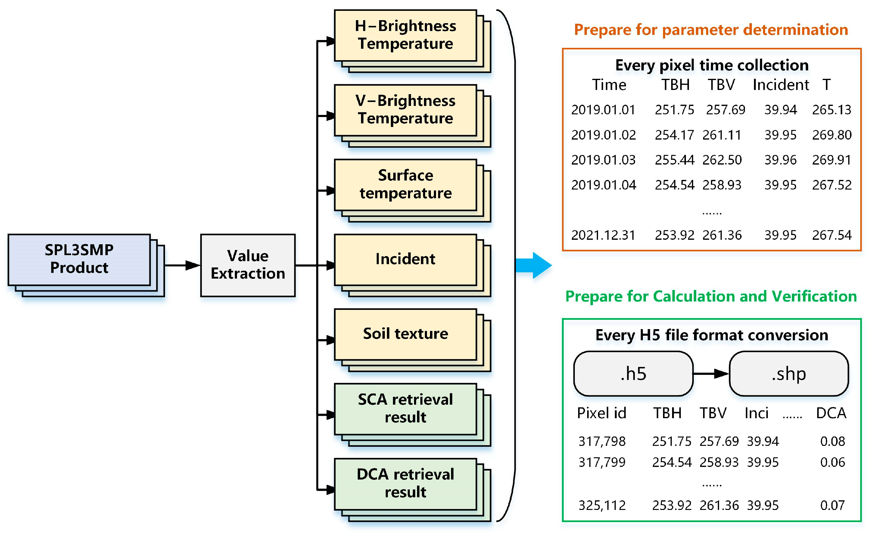
This study utilized the SMAP Level-3 Radiometer Global Daily 36 km EASE-Grid Soil Moisture Product (SPL3SMP) provided by the Soil Moisture Active Passive (SMAP) mission of the National Aeronautics and Space Administration (NASA). The product is generated from L-band passive microwave observations acquired by the SMAP radiometer. The orbital-scale soil moisture retrievals are obtained using the official SMAP soil moisture retrieval algorithms and further processed through daily compositing to generate global daily soil moisture estimates. The dataset is projected onto the Equal-Area Scalable Earth Grid Version 2.0 (EASE-Grid 2.0) with a spatial resolution of 36 km. The SPL3SMP product includes soil moisture retrievals from the DCA and the Single Channel Algorithm (SCA-H and SCA-V) for both morning (AM) and afternoon (PM) overpasses. It also provides auxiliary variables, including horizontally and vertically polarized brightness temperatures (H/V), observation incidence angle, surface temperature, and quality control flags. Among these variables, the brightness temperature and incidence angle information provide important observational constraints for physical-model-based soil moisture retrieval. The dataset is stored in HDF5 and can be accessed through the National Snow and Ice Data Center (NSIDC) and NASA Earthdata Search platforms. To support subsequent analyses, the SMAP L3 dataset was preprocessed through variable extraction and spatial matching, and the detailed procedure is illustrated in Figure 2.
In addition to the SMAP SPL3SMP product, the MCCA soil moisture product, generated using the Multi-Channel Collaborative Algorithm (MCCA) [18], was also collected. This dataset [19] was obtained from the National Tibetan Plateau Data Center (TPDC) and was used for comparison with the retrieval results of the proposed method and the SMAP official products.
The in situ data used in this study were obtained from the Shandian River Basin Soil Temperature and Moisture Wireless Sensor Network Dataset (2019–2025) [20], which is publicly available from the National Tibetan Plateau Data Center. The dataset consists of 34 automatic monitoring stations distributed across the basin and provides continuous soil temperature and moisture observations at 10–15 min intervals. Measurements are available at depths of 3, 5, 10, 20 and 50 cm. In this study, the 5 cm soil moisture observations were selected as the ground reference for validating the SMAP surface soil moisture retrievals, following the commonly adopted depth in SMAP calibration and validation and L-band satellite soil moisture validation studies [21,22]. Although the effective sensing depth of L-band observations varies with soil moisture conditions and does not strictly correspond to 5 cm, the 5 cm observations provide a consistent and widely used reference for SMAP validation.

3. Method

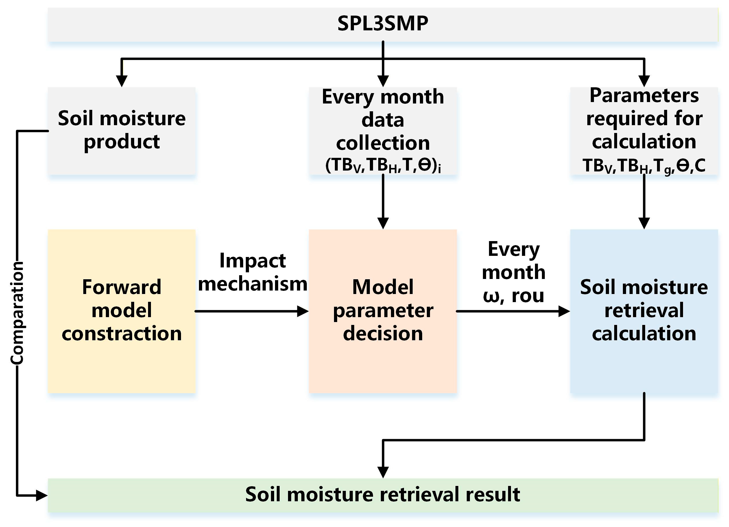
The proposed method consists of three main steps: forward model construction, model parameter determination, and soil moisture retrieval. The overall process is shown in Figure 3.

3.1. Forward Model Construction

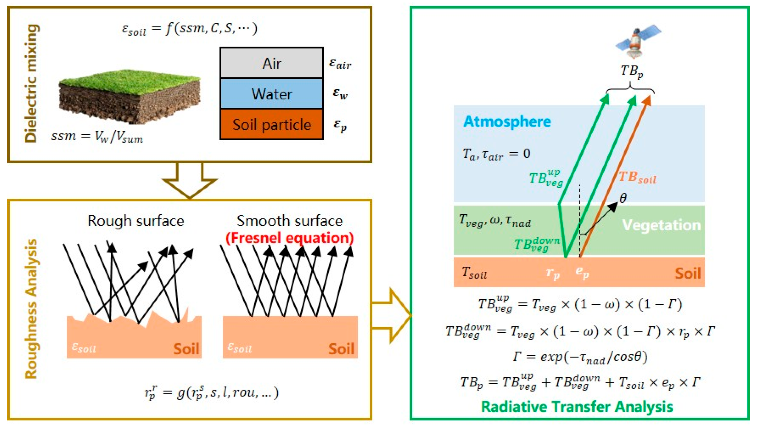
A forward model for passive microwave soil moisture retrieval was developed by integrating a soil dielectric mixing model, a surface roughness model, and a radiative transfer model. The model describes the physical relationship between soil moisture and land surface brightness temperature, and the overall workflow is illustrated in Figure 4.
The soil dielectric constant is a key parameter linking soil moisture variations with microwave responses. Existing soil dielectric mixing models mainly include the Topp model [23], Wang model [24], Dobson model [25], and Mironov model [26], which characterize variations in soil dielectric properties as functions of soil moisture and soil texture parameters. Among these models, the Mironov model is based on physical dielectric mixing theory and exhibits high accuracy and applicability under different soil types and moisture conditions [27]. Therefore, the Mironov model was adopted in this study to calculate the soil dielectric constant. Considering that the SMAP sensor operates at the L-band frequency, the modified parameters proposed for the L-band in [28] were applied for calculation.
{ ε = n s 2 ( s s m , C , T s ) k s 2 ( s s m , C , T s )     ε = 2 n s ( s s m , C , T s ) k s ( s s m , C , T s )
In the equation, ε and ε represent the real and imaginary parts of the complex soil dielectric constant, respectively; s s m denotes soil moisture content; C represents the percentage of clay content; and T s indicates soil temperature.
Based on the obtained soil dielectric constant, the reflectivity of the smooth soil surface can be calculated using the Fresnel equations, as shown in Equations (2) and (3). However, surface roughness alters microwave scattering characteristics; therefore, roughness correction is required to modify the smooth surface reflectivity. Since SMAP operates at the L-band frequency, the cross-polarization conversion between horizontal and vertical polarizations caused by surface roughness is relatively weak and can generally be neglected. Therefore, the Hp roughness model developed for the L-band was adopted to correct the soil surface reflectivity, and its expression is given as Equation (4).
r H s = | c o s θ ε s i n 2 θ c o s θ + ε s i n 2 θ | 2
r V s = | ε c o s θ ε s i n 2 θ ε c o s θ + ε s i n 2 θ | 2
r p = r p s × H p
H p = A 1 , p e x p ( A 2 , p × r o u 2 + A 3 , p × r o u )
A i , p = a i , p , 1 × θ 2 + a i , p , 2 × θ + a i , p , 3
In the equations, r H s and r V s denote the reflectance of the horizontally and vertically polarized smooth soil surfaces, respectively; θ is the incidence angle; r p represents the reflectance of the p -polarized rough soil surface; H p is the roughness correction parameter, calculated as shown in (5); r o u is the roughness slope parameter used to characterize the geometric roughness of the soil surface, defined as s 2 / l , where s denotes the root-mean-square (RMS) surface height and l denotes the correlation length; A 1 , p , A 2 , p and A 3 , p are intermediate parameters related to the incidence angle, calculated as shown in (6); and a i , p , 1 , a i , p , 2 and a i , p , 3 are empirical coefficients listed in Table 1, whose values are taken from [29].
After obtaining the rough soil surface reflectivity, the radiative transfer model was further used to describe the effects of the soil–vegetation system on microwave radiation transfer. Since L-band microwave signals exhibit strong atmospheric penetration capability, atmospheric attenuation is generally ignored. Therefore, the τ ω radiative transfer model was adopted to establish the relationship between rough soil surface reflectivity and observed brightness temperature, which is expressed as follows:
T B p = T s e p Γ + T v ( 1 ω ) ( 1 Γ ) + T v ( 1 ω ) ( 1 Γ ) Γ r p
Γ = e x p ( τ n a d / c o s θ )
In the equation, T B p represents the land surface brightness temperature, where the subscript p denotes the polarization; T s and T v are the soil and vegetation temperatures, respectively. Since vegetation temperature is generally unavailable and treating it as an independent variable would increase the number of unknown model parameters, a simplification is commonly adopted in soil moisture retrieval studies. Moreover, the SMAP overpass occurs at approximately 6:00 a.m. and 6:00 p.m. local solar time, when the temperature difference between the soil and vegetation is typically small. Therefore, this study assumes that the soil and vegetation temperatures are equal, i.e., T s = T v = T g . The parameter ω is the vegetation single-scattering albedo; Γ denotes the vegetation transmissivity, calculated as shown in Equation (8); τ n a d is the nadir vegetation optical depth; θ is the incidence angle; and e p is the p-polarized emissivity of the rough soil surface, which is commonly assumed to satisfy e p + r p = 1 in soil moisture retrieval studies.
By combining Equations (1)–(8), the functional relationship between soil moisture and surface brightness temperature can be derived, as expressed in Equations (9) and (10).
T B H = T g ( 1 r H ( ε ( s s m , C , T g ) , θ , r o u ) ) Γ ( τ , θ ) + T g ( 1 ω ) Γ ( τ , θ ) + T g ( 1 ω ) ( 1 Γ ( τ , θ ) ) Γ ( τ , θ ) r H ( ε ( s s m , C , T g ) ,   θ , r o u )
T B V = T g ( 1 r V ( ε ( s s m , C , T g ) , θ , r o u ) ) Γ ( τ , θ ) + T g ( 1 ω ) Γ ( τ , θ ) + T g ( 1 ω ) ( 1 Γ ( τ , θ ) ) Γ ( τ , θ ) r V ( ε ( s s m , C , T g ) , θ , r o u )

3.2. Method for Determining Model Parameters

After constructing the forward model, the collected multi-source auxiliary datasets were integrated into the model. The dual-polarized brightness temperatures, incidence angle, land surface temperature, and soil texture parameters were regarded as known inputs. Therefore, the remaining unknown variables in the forward model include surface soil moisture ( s s m ), vegetation optical depth ( τ ), soil surface roughness parameter ( r o u ), and vegetation single-scattering albedo ( ω ). Among them, s s m and τ are the target variables for soil moisture retrieval, whereas r o u and ω are model parameters. Accurate determination of these parameters is essential for reliable retrieval of soil moisture and vegetation optical depth.
Because regional-scale, long-term observations of soil surface roughness and vegetation single-scattering albedo are generally unavailable, existing passive microwave soil moisture retrieval algorithms generally treat them as priori fixed parameters to reduce the number of unknown variables and improve computational efficiency. For example, in single-channel algorithms, dual-channel algorithms, and multi-channel algorithms, r o u and ω are commonly assumed to remain constant over relatively long periods (e.g., annual scales). However, actual surface conditions are affected by precipitation, vegetation growth, and land surface changes, resulting in temporal variations in soil roughness and vegetation scattering characteristics. Therefore, long-term fixed parameters may not fully represent dynamic surface conditions. Considering that both parameters are expected to remain relatively stable within a short time window, this study assumes that r o u and ω are approximately constant within one month and updates them on a monthly basis rather than using conventional long-term fixed values, thereby improving the adaptability of the forward model to temporal variations in surface conditions.
Based on this assumption, multi-temporal observations within the same time window share identical r o u and ω values, allowing multiple brightness temperature observations to provide joint constraints on these parameters. By extending Equations (9) and (10) to the entire parameter estimation period, a multi-temporal joint equation system can be established, as shown in Equation (11).
{ T B H , 1 = T g , 1 ( 1 r H ( ε 1 , θ 1 , r o u ) ) Γ + T g , 1 ( 1 ω ) Γ ( τ 1 , θ 1 ) + T g , 1 ( 1 ω ) ( 1 Γ ( τ 1 , θ 1 ) ) Γ ( τ 1 , θ 1 ) r H ( ε 1 , θ 1 , r o u ) T B V , 1 = T g , 1 ( 1 r V ( ε 1 , θ 1 , r o u ) ) Γ ( τ 1 , θ 1 ) + T g , 1 ( 1 ω ) Γ ( τ 1 , θ 1 ) + T g , 1 ( 1 ω ) ( 1 Γ ( τ 1 , θ 1 ) ) Γ ( τ 1 , θ 1 ) r V ( ε 1 , θ 1 , r o u ) T B H , n = T g , n ( 1 r H ( ε n , θ n , r o u ) ) Γ ( τ n , θ n ) + T g , n ( 1 ω ) Γ ( τ n , θ n ) + T g , n ( 1 ω ) ( 1 Γ ( τ n , θ n ) ) Γ ( τ n , θ n ) r H ( ε n , θ n , r o u ) T B V , n = T g , n ( 1 r V ( ε n , θ n , r o u ) ) Γ ( τ n , θ n ) + T g , n ( 1 ω ) Γ ( τ n , θ n ) + T g , n ( 1 ω ) ( 1 Γ ( τ n , θ n ) ) Γ ( τ n , θ n ) r V ( ε n , θ n , r o u )
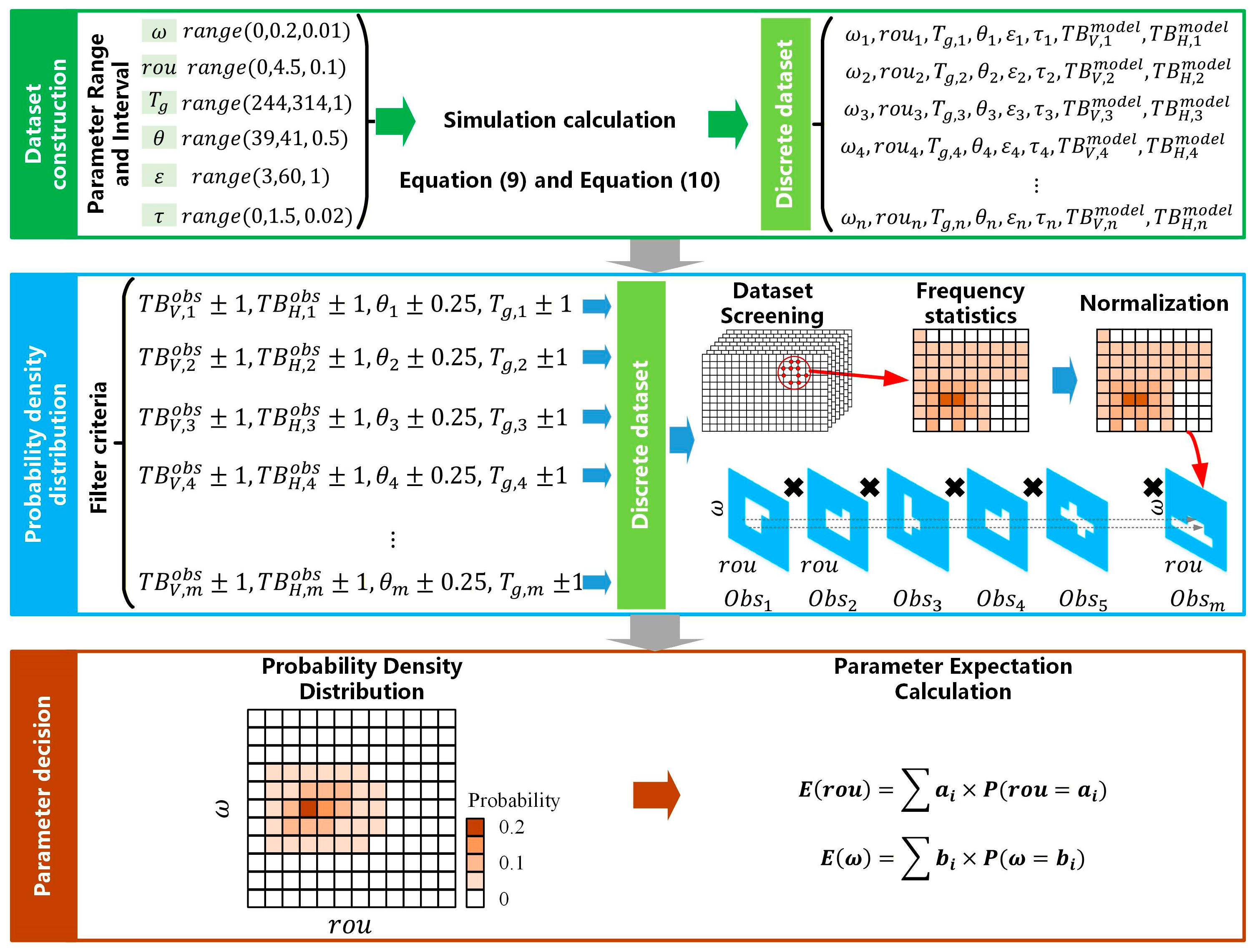
Although multi-temporal observations increase model constraints and improve parameter estimation stability, the equation system remains underdetermined because unknown variables such as soil dielectric constant and vegetation optical depth are still involved at each observation time. Therefore, r o u and ω cannot be directly solved using conventional analytical methods. To address this issue, a method combining a discrete parameter space and probabilistic statistics was proposed in this study to jointly determine the soil surface roughness parameter and vegetation single-scattering albedo. The overall procedure is illustrated in Figure 5.
First, ε , τ , r o u , ω , T g , and θ are defined as the dimensions of the discrete parameter space. The variation range of each parameter is predefined by considering its physical meaning, the applicable range of the forward model, and computational efficiency, as summarized in Table 2. To ensure that the parameter space adequately covers the conditions that may occur in practical applications, the ranges are determined with reference to relevant observations and previous studies. Specifically, the range of surface temperature is determined based on the global extremes (excluding Antarctica) reported by existing land surface temperature products; the incidence-angle range is defined according to the actual observation geometry of SMAP; and the ranges of τ , ω , and r o u are determined with reference to the global parameter-estimation results reported in [18], covering their observed extreme values. Based on these ranges, the intervals between adjacent parameter values are selected by balancing the resolution of parameter sampling and computational efficiency, thereby ensuring sufficient coverage of the parameter space while avoiding unnecessary computational costs. Subsequently, the dual-polarized brightness temperatures corresponding to all parameter combinations are simulated according to Equations (9) and (10), and a discrete dataset consisting of { T B V , i m o d e l , T B H , i m o d e l } is constructed.
Then, multi-temporal observations within the parameter estimation window, including T B V o b s , T B H o b s , T g o b s , and θ o b s , were used to filter the discrete simulation dataset. Specifically, data points satisfying the following conditions were retained: T B V o b s ± σ T B V , T B H o b s ± σ T B H , T g o b s ± σ T g , θ o b s ± σ θ . where σ represents the allowable uncertainty. In this study, σ T B V = σ T B H = σ T g = 1 K and σ θ = 0.25 ° . For each observation, the selected data points were projected into the r o u ω parameter space. The occurrence frequency of different parameter combinations was counted and normalized to obtain the probability distributions of r o u and ω under the constraint of each observation. Since satisfying multiple independent observations simultaneously is equivalent to satisfying the joint constraints of individual observations, the probability distributions derived from different observations were combined according to the probability multiplication principle, as expressed in Equation (12). Finally, the joint probability distribution of r o u and ω under multi-temporal constraints was obtained.
P ( r o u , ω | o b s 1 , o b s n ) = P ( r o u , ω | o b s i )
Finally, the marginal probability distributions of the soil surface roughness parameter ( r o u ) and vegetation single-scattering albedo ( ω ) were derived from their joint probability distribution, and the expected value of each parameter was calculated as its corresponding parameter estimate.
Notably, to reduce the influence of a small number of large-error observations among multiple remote sensing observations acquired within the same period, 10% of the observations were randomly excluded before each parameter estimation, and the above procedure was repeated 30 times. Finally, the mean of the parameter estimates obtained from the 30 repetitions was taken as the final parameter estimate to reduce the influence of anomalous observations.

3.3. Soil Moisture Retrieval Calculation

Based on the above parameter determination method, a set of soil surface roughness parameter ( r o u ) and vegetation single-scattering albedo ( ω ) values was determined for each month and subsequently treated as fixed model parameters for all soil moisture retrievals within that month. After obtaining r o u and ω , they were substituted into Equations (9) and (10). For each remote sensing observation, the dual-polarized brightness temperatures, land surface temperature, and incidence angle were known variables. Therefore, only surface soil moisture ( s s m ) and vegetation optical depth ( τ ) remained as unknown parameters. However, Equations (9) and (10) form a highly nonlinear coupled equation system, making analytical solutions difficult to obtain. Therefore, numerical optimization methods are required for parameter estimation.
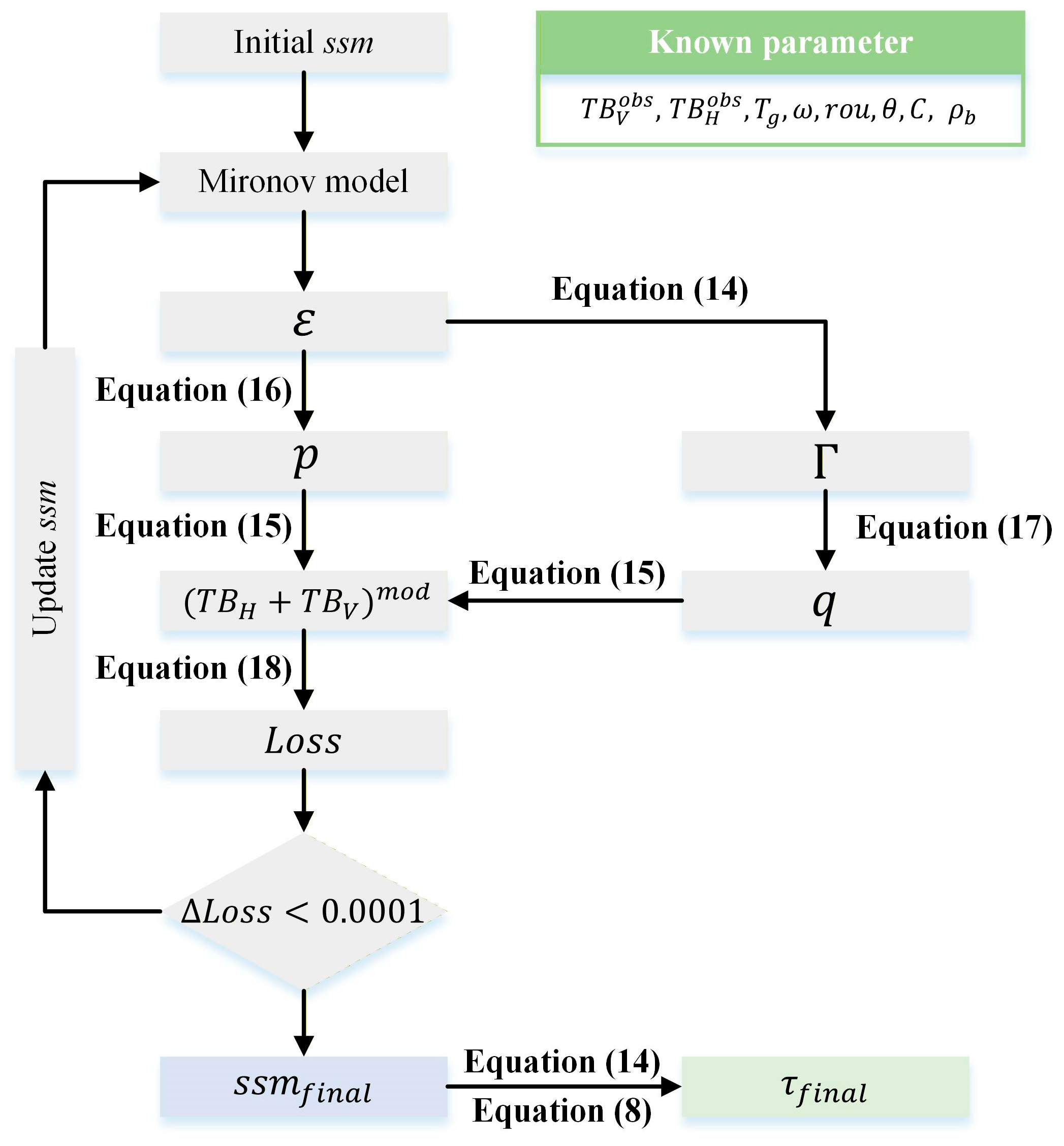
Traditional methods generally treat s s m and τ as jointly optimized variables and iteratively solve them by constructing a cost function between simulated and observed brightness temperatures. However, the strong nonlinear coupling among multiple parameters may reduce parameter estimation stability and increase computational complexity. Therefore, a single-parameter optimization strategy was adopted in this study to transform the original two-parameter retrieval problem into a single-parameter optimization problem dependent only on surface soil moisture. Specifically, under the conditions that dual-polarized brightness temperatures, land surface temperature, incidence angle, r o u , and ω are known, the horizontal polarization brightness temperature equation (Equation (9)) was rearranged into a quadratic equation with respect to vegetation transmissivity Γ, as shown in Equation (13). By solving this equation, the functional relationship between vegetation transmissivity Γ and soil dielectric constant ε was established. Furthermore, based on the Mironov dielectric mixing model, the relationship between soil dielectric constant ε and surface soil moisture was obtained, thereby establishing the constraint relationship between Γ and s s m . Consequently, vegetation optical depth τ was no longer treated as an independent optimization variable but was indirectly determined by s s m . This transformation converted the original two-parameter joint optimization problem into a single-parameter optimization problem, improving model stability and computational efficiency.
{ T B H = a Γ 2 + b Γ + c a = T g ( 1 ω ) r H ( ε ,   θ ,   r o u ) b = ω T g ( 1 r H ( ε ,   θ ,   r o u ) ) c = T g ( 1 ω )
Γ = b ± b 2 4 a c 2 a
Furthermore, by applying summation and subtraction operations to Equations (9) and (10), and incorporating the established Γ ε s s m relationship, the functional relationship between the sum and difference in dual-polarized brightness temperatures and s s m was constructed, as shown in Equation (15). Based on this relationship, cost functions were established using the simulated and observed dual-polarized brightness temperature sums and differences, as expressed in Equation (18).
T B H + T B V = ( T B V T B H ) × p + q
p = 2 r H ( ε ( s s m ) , θ , r o u ) r V ( ε ( s s m ) , θ , r o u ) r H ( ε ( s s m ) , θ , r o u ) r V ( ε ( s s m ) , θ , r o u )
q = 2 T g ( 1 ω ) ( 1 Γ ) ( 1 + Γ )
L o s s = [ ( T B V o b s T B H o b s ) × p + q ( T B V o b s + T B H o b s ) ] 2
Finally, the s s m corresponding to the minimum value of the cost function was obtained through iterative optimization and regarded as the final retrieval result. Meanwhile, the corresponding τ was further calculated based on Equations (8) and (14). The overall optimization procedure of soil moisture retrieval is illustrated in Figure 6.

4. Results

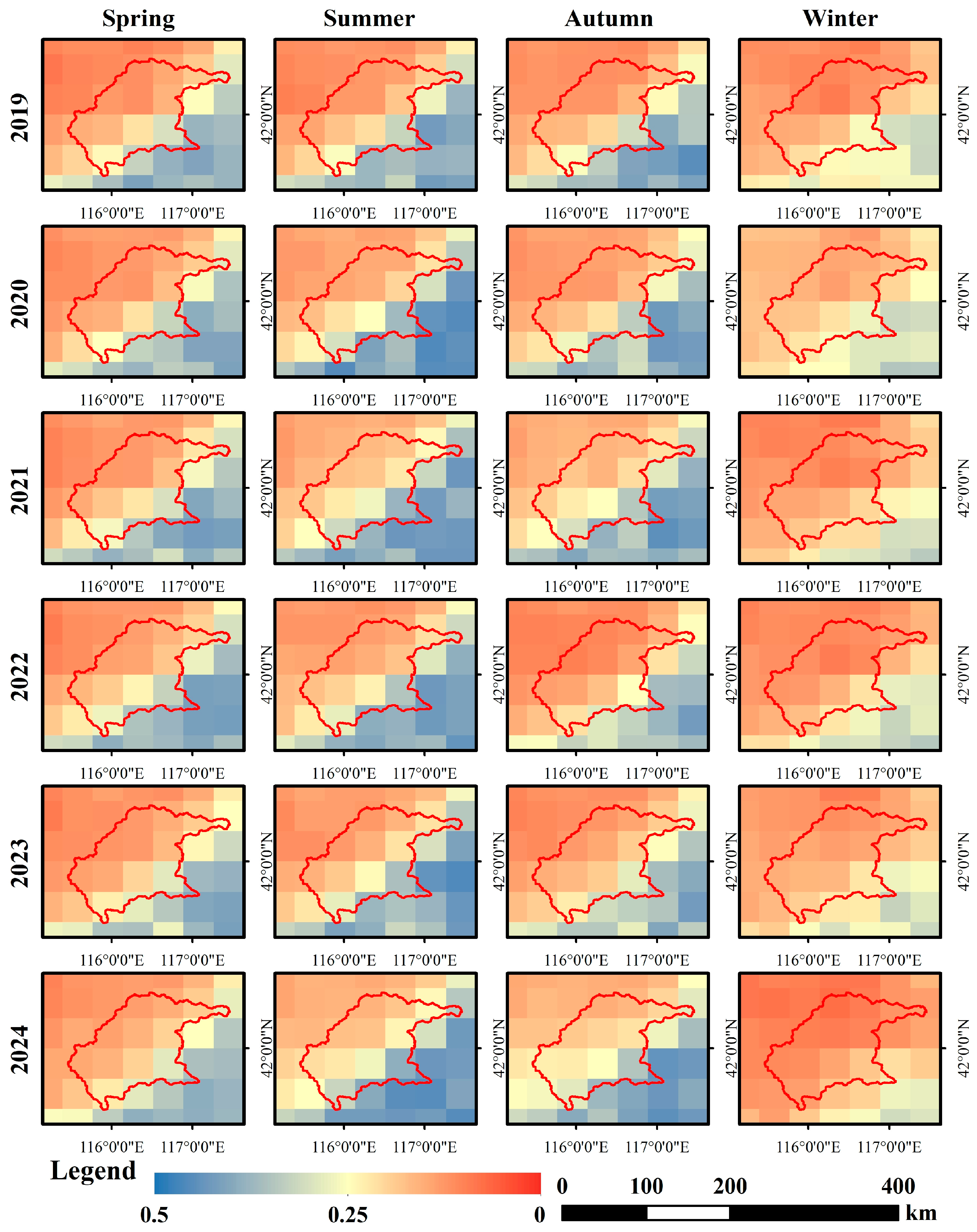
To evaluate the effectiveness of the proposed soil moisture retrieval method, SMAP SPL3SMP products from 2019 to 2024 were used to perform soil moisture retrieval experiments in the Shandian River Basin. Based on the proposed parameter determination method and single-parameter iterative retrieval algorithm, temporal soil moisture results were obtained and further aggregated into monthly and seasonal averages. The spatial distributions of soil moisture for spring, summer, autumn, and winter during 2019–2024 are presented in Figure 7.
As shown in Figure 7, the spatial distributions of soil moisture remained generally consistent across different years and seasons, and the retrieval results exhibited good spatial continuity. Spatially, soil moisture showed an overall increasing pattern from northwest to southeast, with relatively lower values in the upstream region and higher values in the downstream region. Regarding seasonal variations, similar patterns were observed among different years, with higher soil moisture values in summer, lower values in winter, and transitional conditions in spring and autumn.
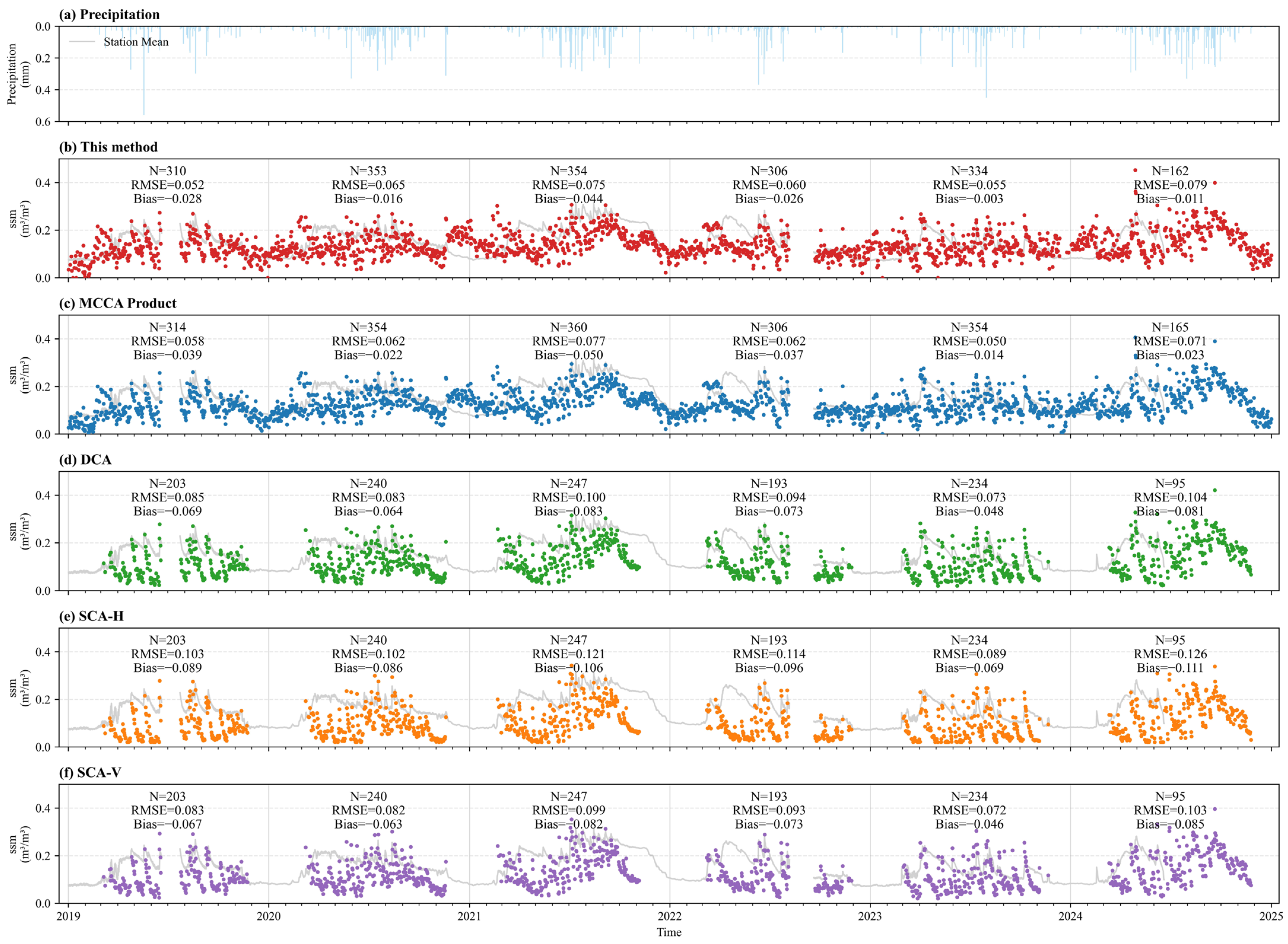
Figure 8 presents the time series comparison between different soil moisture retrieval methods and ground observations within a representative grid cell with relatively high ground-observation coverage in the study area during 2019–2024. The selected grid cell contains 14 ground-based monitoring stations. To reduce the effects of anomalous station observations and temporal differences around the satellite overpass, station observations within ±1 h of the satellite overpass time were selected, and anomalous measurements were excluded. The valid station observations were then averaged to obtain a pixel-scale ground-based soil moisture reference, which was compared with the corresponding remotely sensed retrievals. The gray curves represent the 5 cm soil moisture observations from the ground-based monitoring network, while the colored scatter points represent the retrieval results from the proposed method, the official SMAP products (DCA, SCA-H, and SCA-V), and the MCCA product. The number of valid matched samples (N), root mean square error (RMSE), and bias (Bias) for each year are also provided. The time series results show that the soil moisture variations retrieved by different methods were generally consistent, indicating that all methods were able to capture the temporal dynamics of soil moisture in the study area. However, differences existed among the accuracy metrics of different methods. The proposed method achieved relatively lower RMSE and Bias values in most years, with better accuracy metrics than DCA, SCA-H, and SCA-V, while maintaining comparable performance with the MCCA product.
Furthermore, to ensure a consistent evaluation basis among different methods, only the common valid matched samples shared by all methods were selected for statistical analysis, and the results are presented in Table 3. Under the unified sample condition, the RMSE, MRE, and Bias values of the proposed method were 0.0678, 0.3085, and −0.0453, respectively, achieving better evaluation metrics than those of MCCA, DCA, SCA-H, and SCA-V products.

5. Discussion

5.1. Method Verification and Parameter Variation Analysis

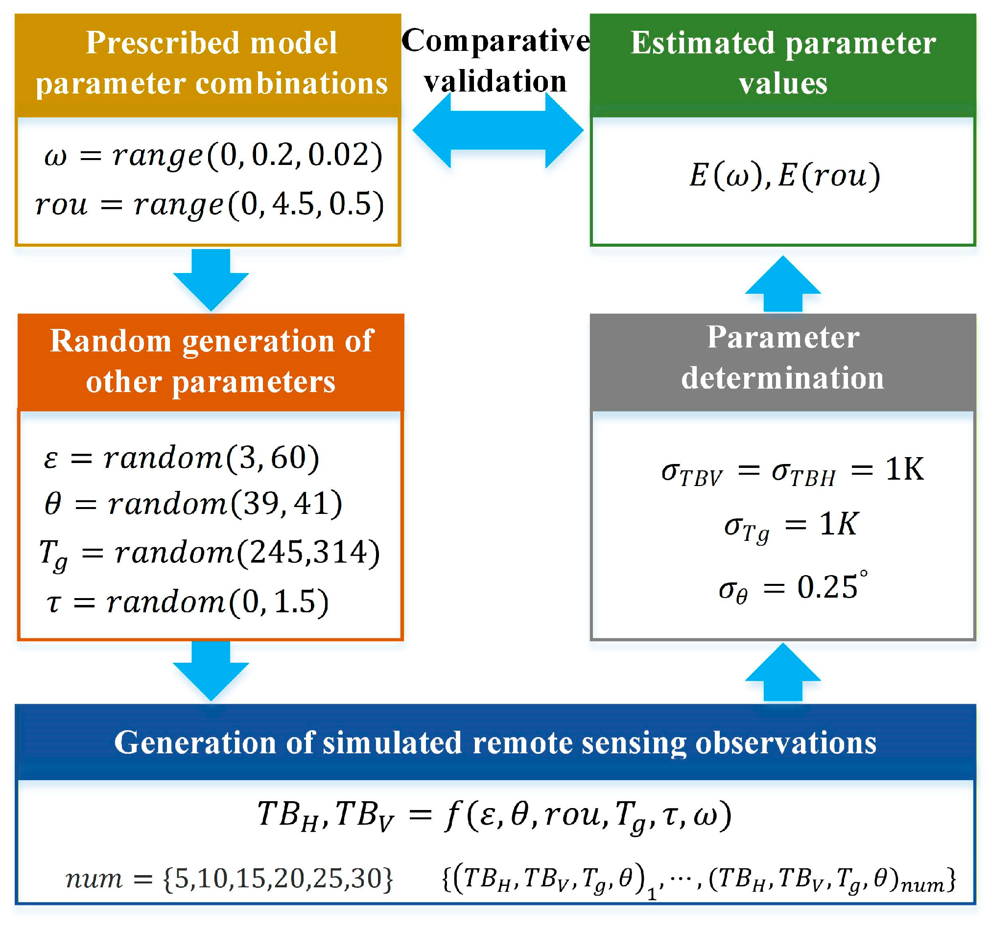
To evaluate the accuracy of the parameter estimation method, a hypothetical validation experiment was designed in the absence of measured reference parameters. First, multiple combinations of the soil surface roughness parameter and vegetation single-scattering albedo were prescribed within their respective predefined ranges. Meanwhile, multiple sets of simulated state parameters were randomly generated within the specified ranges of incidence angle, land surface temperature, soil moisture, and vegetation optical depth. These parameter combinations were then used as inputs to the forward model to simulate dual-polarization brightness temperatures. The simulated brightness temperatures were subsequently treated as observations and input into the proposed parameter estimation method to retrieve the soil surface roughness parameter and vegetation single-scattering albedo. The retrieved parameters were compared with their initially prescribed values, and the corresponding accuracy metrics were calculated based on 30 repeated experiments to evaluate the performance of the parameter estimation method. The overall workflow of the validation experiment is shown in Figure 9.
The validation results are presented in Table 4. From the results, it can be seen that: (1) the proposed method has a good capability for parameter identification. Considering the overall variation ranges of the two parameters, the RMSE values of r o u and ω remain below 0.6 and 0.01, respectively, even with only five observations, indicating that the method can effectively identify variations in both parameters over relatively broad ranges under limited-observation conditions; (2) the estimation accuracy of ω is generally higher than that of r o u , which may be related to their different pathways of influence in the model. Specifically, ω directly participates in the vegetation radiative transfer process and affects brightness temperature, whereas r o u affects brightness temperature indirectly through its influence on soil reflectivity or emissivity. Therefore, the estimation accuracy of ω is relatively higher; and (3) increasing the number of observations can substantially improve the estimation accuracy of both parameters, but the improvement exhibits a diminishing-return characteristic. As the number of observations increases from 5 to 30, both the RMSE and MRE of r o u and ω continuously decrease, indicating that additional multi-temporal observations provide stronger constraints on the parameter estimates. However, once the number of observations reaches 20, further increasing the number of observations yields relatively limited improvements in estimation accuracy.
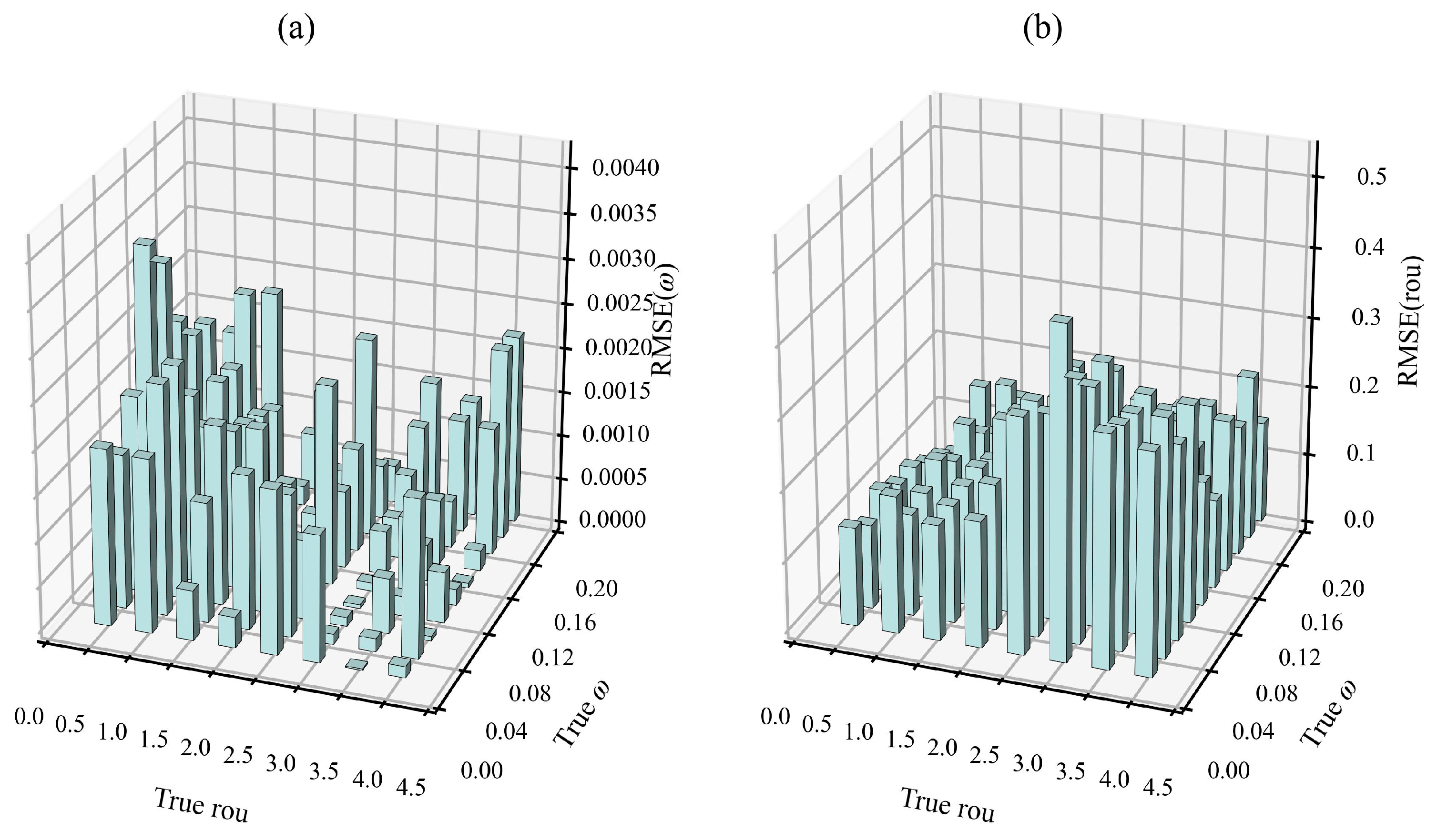
The study area is located in the mid-latitude region. According to the statistics of this study, more than 25 SMAP observations are available in most months. Figure 10 presents the estimation accuracy of the proposed method for different combinations of ω and r o u under 25 observations. The results show that the estimation accuracy varies to some extent across different parameter combinations, but no distinct regions of estimation failure are observed. For ω , the overall RMSE is approximately 0.0015, with the relatively higher local errors remaining below 0.004. For r o u , the overall RMSE is approximately 0.2147, with the maximum local error remaining below 0.45. These results indicate that although the estimation accuracy varies with the location of the true parameter values within the parameter space, the overall errors remain within an acceptable range, demonstrating relatively stable parameter estimation performance under the actual observation conditions in the study area.
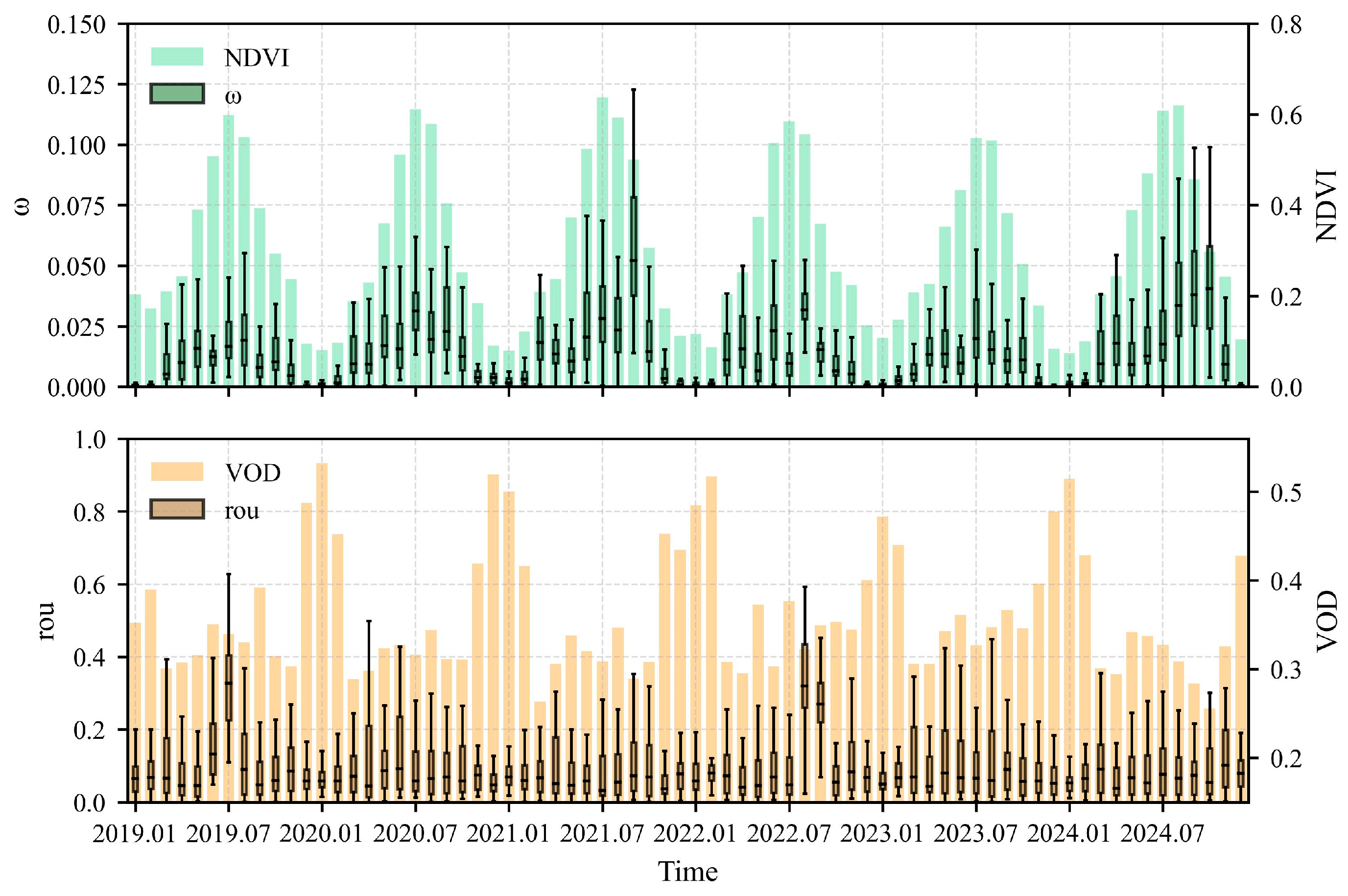
Following the validation of the parameter estimation method, the temporal variability of the key parameters in the forward model for soil moisture retrieval was further analyzed. The monthly ω and r o u estimated for the Shandian River Basin and its surrounding pixels during 2019–2024 were statistically analyzed. Their temporal variations were illustrated using monthly boxplots, as shown in Figure 11.
As shown in Figure 11, the retrieved ω in the study area exhibits distinct intra-annual variability. Based on the monthly mean values, ω shows an intra-annual variation of approximately 0.02 across different years, which is substantially larger than the estimation error of the parameterization method. This indicates that the observed variation is not primarily attributable to parameter estimation error, but reflects pronounced seasonal variability in ω , demonstrating that the proposed method is capable of effectively detecting the intra-annual dynamics of this parameter. Furthermore, ω exhibits a relatively consistent seasonal pattern during 2019–2024, remaining at a low level in winter, increasing gradually in spring, reaching higher values in summer, and declining rapidly in autumn. This pattern is broadly consistent with the seasonal variation in ω reported for grasslands in [30], providing further support for the reasonableness of the ω estimates obtained in this study. Despite the consistency in seasonal variation, the absolute values of ω estimated in this study are generally lower than those reported in [30]. This discrepancy may be related to differences in the study regions and parameterization approaches. On the one hand, [30] conducted a global-scale parameterization of ω , but no corresponding valid parameterization results were obtained for the present study region because of the relatively large uncertainty in the vegetation height data. Therefore, the study regions considered in the two studies are not completely consistent. On the other hand, the parameterization procedures differ substantially. Ref. [30] used the MT-DCA soil moisture product, vegetation height, and other parameters as known inputs and iteratively optimized ω by minimizing the discrepancy between forward-simulated and observed brightness temperatures, whereas the method proposed in this study estimates ω from multi-temporal brightness temperatures without prior knowledge of soil moisture. Consequently, differences in the input data and their potential systematic errors may result in differences in the absolute magnitude of ω estimated by the two approaches, while their seasonal variation patterns remain reasonably consistent. In addition, the ω values adopted by the MCCA method in the study area were further examined [18]. The results show that the ω values adopted by MCCA are also lower than the fixed values of 0.05 and 0.07 used by the conventional SMAP SCA and DCAs, respectively, and generally remain below 0.05, providing further support for the reasonableness of the ω estimates obtained in this study. However, a lower ω reduces the relative contribution of the vegetation scattering term to the observed brightness temperature and correspondingly increases the relative contribution of soil emission, which may consequently lead to higher retrieved soil moisture values.
In contrast, the soil surface roughness parameter ( r o u ) does not exhibit a pronounced seasonal variation. As shown in Figure 11, except for June-July 2019 and August-September 2022, r o u generally remains within a relatively stable range across different years. The number of valid SMAP observations in these anomalous months was relatively small, with fewer than 10 observations in most months. Under a limited number of observations, the parameterization error of r o u may exceed 0.4, whereas r o u mainly varies within the range of 0–0.2 throughout the year. Therefore, the estimates for these anomalous months may have been affected by insufficient observations and relatively large parameterization errors and cannot reliably characterize the seasonal variation in r o u . These months were therefore excluded from the subsequent analysis. After excluding the above anomalous months, the variation in r o u across different years is generally around 0.1. In contrast, under 25 observations and within the ranges of ω and r o u in the study area, the RMSE of the parameterization method is approximately 0.2. Therefore, the observed variation in r o u is smaller than the parameterization error of the method itself, indicating that the current parameterization results are insufficient to reliably identify the seasonal variation in r o u . In other words, the results do not necessarily indicate that r o u remains constant throughout the year; rather, its potential seasonal variation may be masked by parameter-estimation uncertainty. From a physical perspective, previous studies have shown that soil surface roughness is not strictly a static parameter and may vary with soil moisture, rainfall, and soil management activities [31,32]. Therefore, under the relatively wet conditions in summer, r o u would theoretically be expected to be lower than under the relatively dry conditions in winter. However, this seasonal pattern is not clearly reflected in the results obtained in this study. This difference may be related to the underlying surface characteristics of the study area, the magnitude of the actual roughness variation, and the temporal scale used to characterize the parameter. Study [32] mainly focused on croplands, where roughness variation was strongly affected by periodic agricultural activities such as tillage and harvesting. In contrast, the Shandian River Basin is predominantly covered by grassland, with grassland accounting for more than 85% of most pixels, and is subject to relatively limited periodic tillage disturbance. Therefore, the actual seasonal variation in roughness may be relatively small. In addition, the r o u parameter used in this study is defined as the slope parameter s 2 / l , which is not exactly equivalent to the roughness parameters used in previous studies; thus, the absolute parameter values should not be directly compared across studies. Finally, some roughness variations reported in previous studies occurred over short time scales following rainfall events, whereas r o u in this study was jointly parameterized using multiple SMAP observations within each month. The monthly parameterization may therefore further weaken such short-term variations. Therefore, the lack of pronounced seasonal variation in r o u in the current results should not be interpreted as evidence that soil surface roughness does not vary seasonally. Rather, it is more likely attributable to the combined effects of relatively small actual variations, parameterization uncertainty, and the monthly temporal scale used for parameter characterization.
In addition, the vegetation optical depth (VOD) retrieved in this study generally exhibits a reasonable seasonal variation pattern during summer, but an anomalous increase occurs in winter. Further analysis indicates that this anomaly is mainly associated with snow cover in the study area. Because of the low winter temperatures, snow cover can persist for relatively long periods in the study area, whereas the effects of snow on surface microwave brightness temperatures were not explicitly considered in the modeling process of this study. Consequently, the effects of snow on the observed brightness temperatures may have been partially attributed to the vegetation term, resulting in anomalously high VOD estimates during winter. Therefore, the effects of snow cover should be further considered in the modeling and soil moisture retrieval under winter conditions in future studies.
Overall, the theoretical validation experiments demonstrate that the proposed multi-temporal brightness temperature constraint method is theoretically capable of simultaneously estimating ω and r o u , effectively identifying variations in both parameters over a relatively wide range. The parameterization accuracy further improves with an increasing number of observations. Based on the parameterization results obtained by applying the proposed method to multi-temporal brightness temperatures in the study area during 2019–2024, ω exhibits relatively consistent and pronounced seasonal variations, with its intra-annual variation substantially exceeding the parameterization error, indicating that the proposed method is capable of detecting the intra-annual dynamics of ω . In contrast, the intra-annual variation in r o u is not pronounced, which may be influenced by the relatively large parameterization error, as well as the land-surface characteristics of the study area and the monthly temporal scale used for parameter characterization. Overall, neither parameter exhibits obvious nonphysical temporal fluctuations, indicating that the proposed multi-temporal brightness temperature constraint can, to some extent, derive model parameters with reasonable physical consistency and provide parameter support for passive microwave soil moisture retrieval.

5.2. Comparison and Analysis of Inversion Results

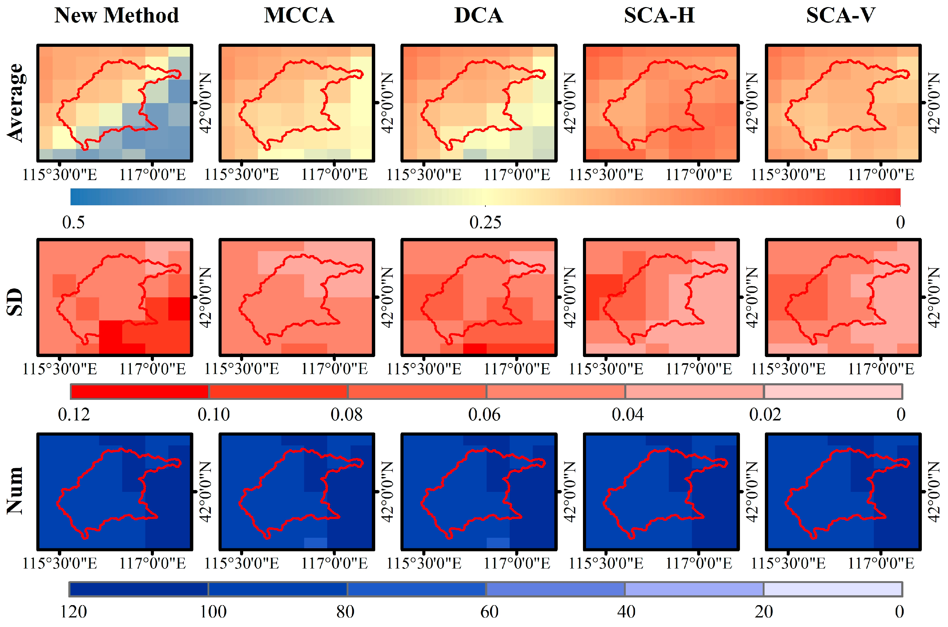
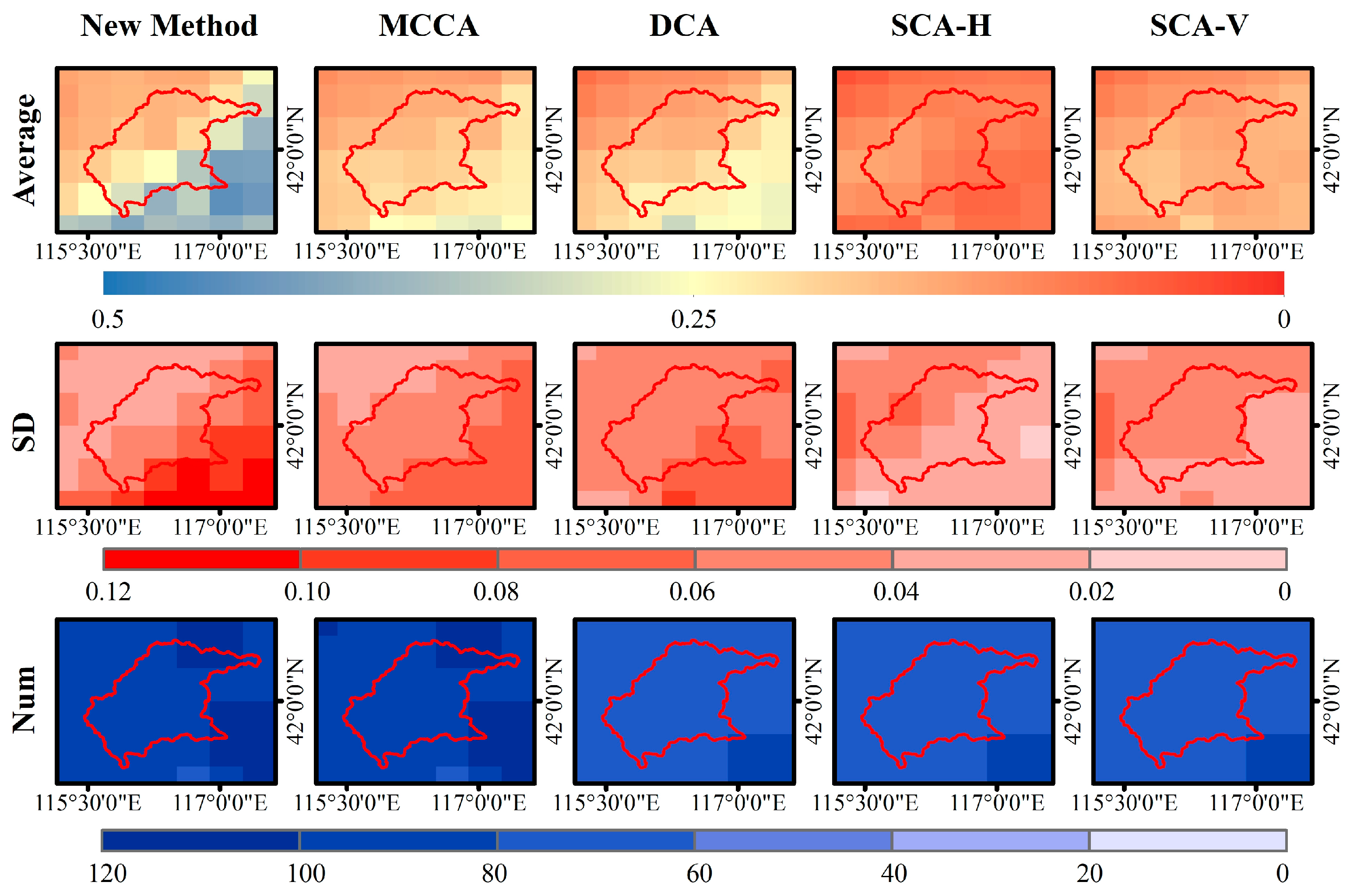
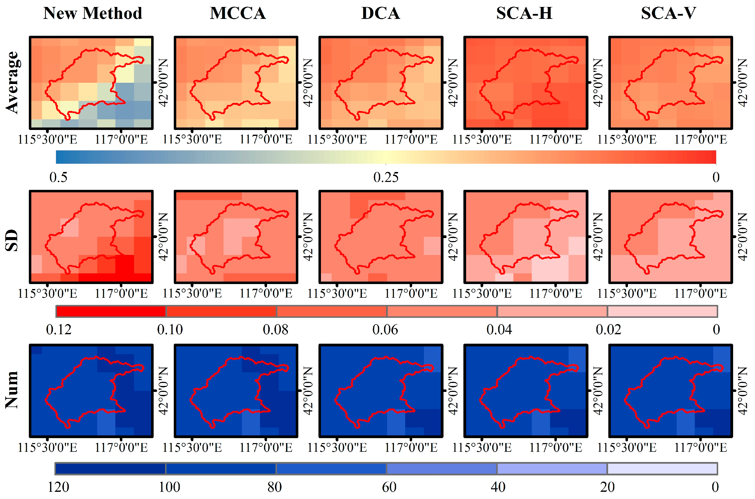
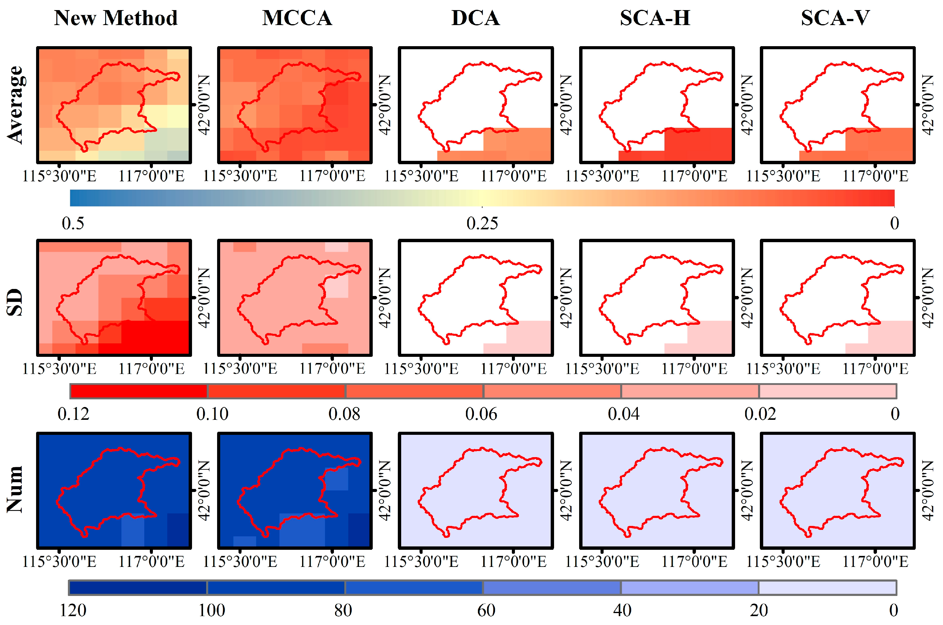
To compare the proposed method with existing soil moisture products, the year 2021, which has relatively complete brightness temperature observations, was selected for analysis. Seasonal mean, standard deviation (SD), and the number of valid retrievals were calculated for each retrieval method. The seasonal mean was used to characterize the spatial distribution of soil moisture, the seasonal standard deviation was used to quantify the temporal variability of the retrievals within each season, and the number of valid retrievals was used to evaluate the capability of each method to provide successful retrievals across the study area. The corresponding results for spring, summer, autumn, and winter are presented in Figure 12, Figure 13, Figure 14 and Figure 15.
Figure 12, Figure 13, Figure 14 and Figure 15 illustrate the spatial distributions of soil moisture retrieved by different methods. Overall, the proposed method exhibits spatial patterns similar to those of the MCCA and DCA products during spring, summer, and autumn, with lower soil moisture in the northwestern part of the basin and higher values in the southeastern part. In addition, soil moisture generally reaches its maximum in summer and minimum in winter. In contrast, the SCA-H and SCA-V products show much weaker spatial gradients and relatively homogeneous spatial distributions, resulting in limited capability to represent the spatial heterogeneity of soil moisture across the study area.
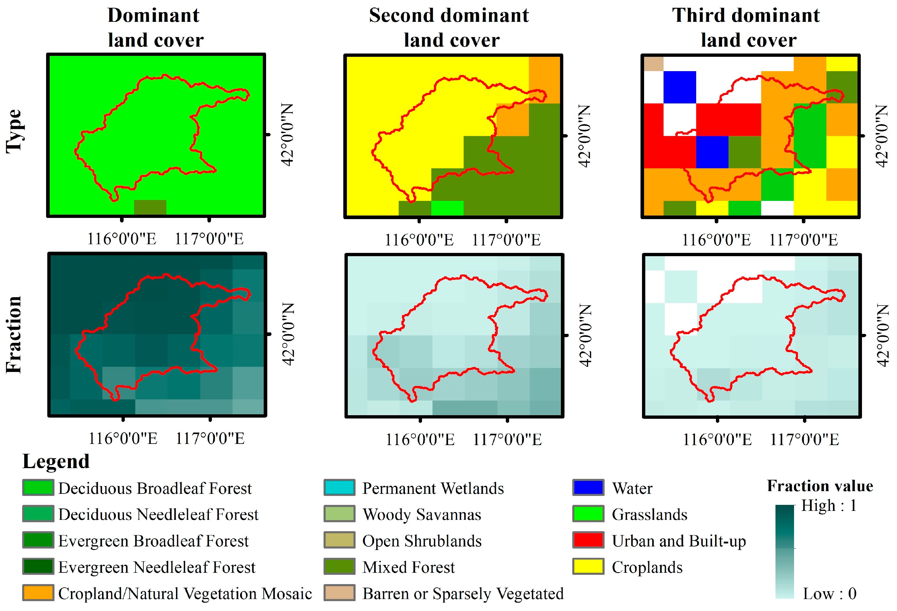
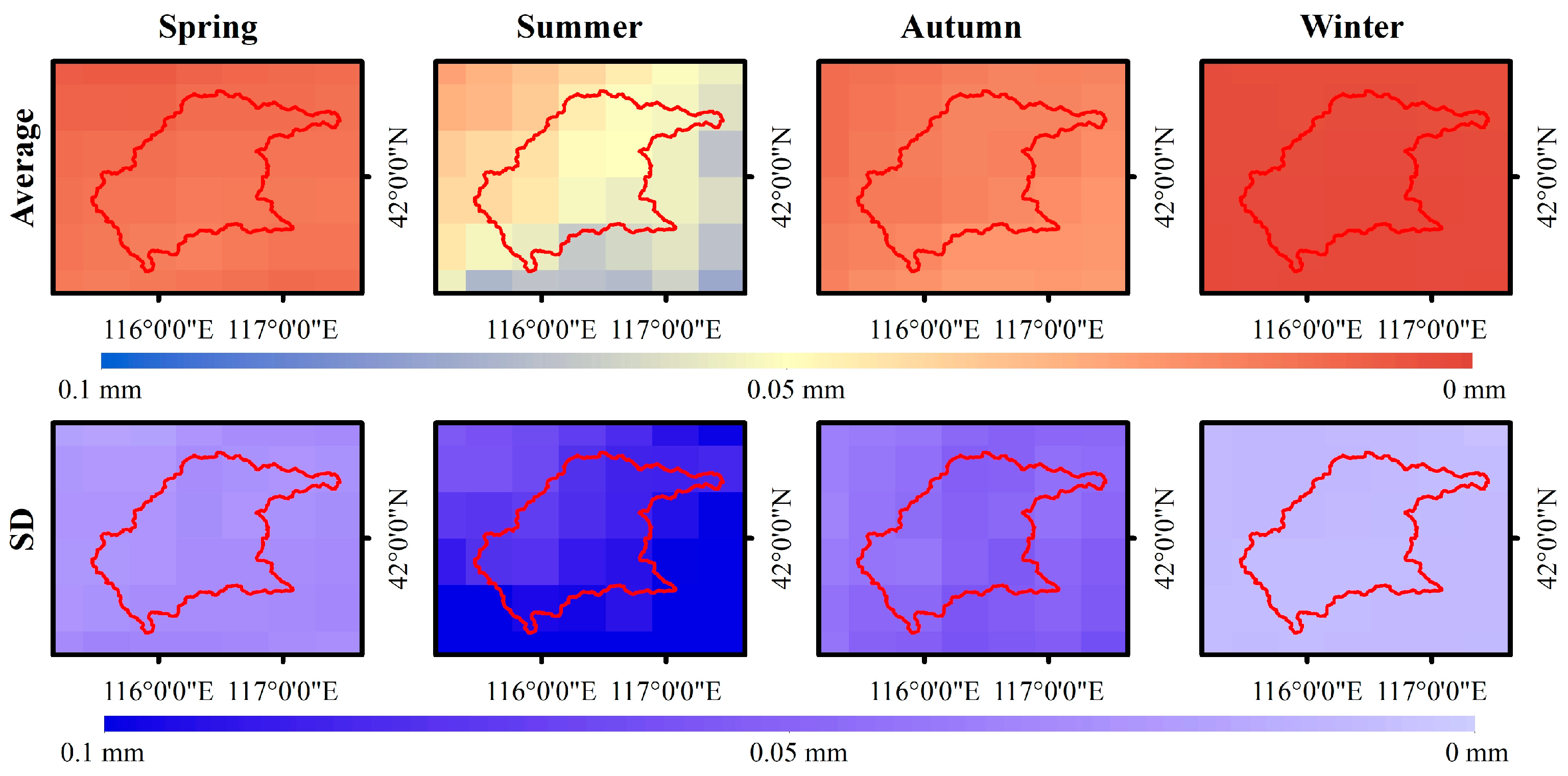
Combined with the land-use map (Figure 16) and the spatial distribution of seasonal mean precipitation (Figure 17), it can be observed that the northwestern part of the basin is mainly covered by grassland and cropland, whereas the southeastern part contains a considerable proportion of mixed forest and is located within the downstream catchment area. Consequently, the southeastern region generally exhibits denser vegetation cover and greater soil water storage capacity. Moreover, seasonal precipitation during summer and autumn also shows a northwest-to-southeast increasing pattern, which is consistent with the spatial distribution of soil moisture. Therefore, the spatial patterns derived from the proposed method, MCCA, and DCA correspond well with the topography, vegetation, and precipitation characteristics of the study area, demonstrating good physical consistency. During winter, the valid retrieval coverage of the DCA, SCA-H, and SCA-V products is limited, whereas only the MCCA product provides complete coverage over the entire basin. Compared with the proposed method, the MCCA product retrieves relatively lower soil moisture in the southeastern region, resulting in a winter spatial pattern that differs from those observed during the other three seasons. Considering that the downstream region is characterized by favorable vegetation cover, greater water storage capacity, and catchment conditions, the relatively wetter conditions retrieved by the proposed method in southeastern areas during winter are more consistent with the actual land surface characteristics of the study area.
A further comparison reveals that the proposed method produces results similar to other products in the relatively dry northwestern region but retrieves generally higher soil moisture in the wetter southeastern region. Consequently, the spatial gradient between dry and wet regions becomes more pronounced, leading to enhanced representation of soil moisture spatial heterogeneity. By comparison, particularly for the SCA-H and SCA-V products, the contrast between regions with different moisture conditions is relatively weak, exhibiting a pronounced spatial homogenization effect. It should be noted that the proposed method still tends to overestimate soil moisture in wet regions, especially in the southeastern part of the basin. According to the parameter analysis, this behavior may be related to the relatively low vegetation single-scattering albedo ( ω ) estimated in this study. A smaller ω may alter the balance between the vegetation scattering term and the soil emission term in the τ ω radiative transfer model, causing the retrieval algorithm to favor relatively higher soil moisture estimates. In addition, differences among retrieval methods in surface roughness parameterization, vegetation parameterization, and dielectric models may also contribute to the discrepancies in the retrieved soil moisture, while their relative contributions require further investigation.
The spatial distribution of seasonal standard deviation also shows differences among the products. Nevertheless, the proposed method exhibits spatial patterns similar to those of the MCCA and DCA products, with relatively small standard deviations in the northwestern region and larger values in the southeastern region. Combined with the seasonal mean soil moisture distribution, the southeastern region generally maintains higher soil moisture levels and experiences stronger variability due to the combined effects of precipitation recharge, evapotranspiration, and runoff convergence. Consequently, seasonal fluctuations are more pronounced in this region. These results indicate that the proposed method is capable of reasonably characterizing both the spatial distribution and temporal variability of soil moisture.
Overall, the proposed method shows good agreement with the MCCA and DCA products in terms of both the overall spatial distribution and temporal variation in soil moisture, while producing more pronounced spatial gradients that better distinguish regions with different moisture conditions and more effectively represent the spatial heterogeneity of soil moisture. Although a certain degree of overestimation remains in wet regions, the retrieved spatial patterns are generally consistent with the natural environmental characteristics of the study area, suggesting that the proposed multi-temporal brightness temperature-constrained parameter determination strategy is applicable for soil moisture retrieval. However, the current parameter determination strategy still has limitations under high soil moisture conditions and requires further refinement.

6. Conclusions

This study proposes a soil moisture retrieval method by jointly constraining the key parameters of the forward model for passive microwave soil moisture retrieval using multi-temporal brightness temperature observations. The proposed method estimates the vegetation single-scattering albedo ( ω ) and soil surface roughness parameter ( r o u ) from multi-temporal brightness temperature observations, thereby reducing the dependence of the forward model on fixed empirical parameters and providing a new approach for determining key parameters in passive microwave soil moisture retrieval. Soil moisture retrieval and validation were conducted over the Shandian River Basin using SMAP SPL3SMP brightness temperature data collected during 2019–2024. The main conclusions are as follows.
  • The proposed parameterization method is theoretically capable of identifying the vegetation single-scattering albedo ( ω ) and soil surface roughness parameter ( r o u ) within their respective parameter ranges, with parameterization accuracy improving as the number of observations increases. The parameterization results based on multi-temporal brightness temperatures in the study area during 2019–2024 show that ω exhibits a pronounced and relatively consistent annual pattern, with a temporal trend generally consistent with previous studies, whereas the intra-annual variation in r o u is less pronounced and cannot be reliably identified from the current parameterization results, possibly due to parameterization uncertainty, the underlying surface characteristics, and the monthly temporal scale used for parameter characterization. Overall, neither parameter exhibits obvious nonphysical temporal fluctuations, indicating that the proposed method can derive model parameters with reasonable physical consistency and provide parameter support for passive microwave soil moisture retrieval.
  • The proposed method provides reliable soil moisture retrievals, with an overall RMSE, ubRMSE, MRE, and Bias of 0.0678, 0.0505, 0.3085, and −0.0453, respectively, based on validation against the ground-based soil moisture observation network. Its retrieval accuracy is superior to that of the DCA and SCA products and generally comparable to that of the MCCA product. Although the ubRMSE is slightly higher than that of MCCA (0.0496), the proposed method exhibits a smaller systematic error, with a Bias closer to zero, resulting in a lower overall RMSE than MCCA (0.0707).
  • In terms of spatial distribution, the proposed method produces spatial patterns generally consistent with those of the MCCA and DCA products, reproducing the dry conditions in the northwestern part of the basin and the relatively wet conditions in the southeastern part while exhibiting more pronounced soil moisture gradients and spatial heterogeneity. The spatial distribution of seasonal standard deviation is also generally consistent with those of the MCCA and DCA products, indicating that the proposed method reasonably captures the temporal variability of soil moisture. Nevertheless, soil moisture is still overestimated in relatively wet regions, suggesting that the current parameterization scheme and forward model require further improvement under high soil moisture conditions.
In summary, the proposed method enables the parameterization of key parameters in the forward model for passive microwave soil moisture retrieval using multi-temporal brightness temperature observations, thereby reducing the reliance on fixed empirical parameters. The theoretical validation and practical application results jointly demonstrate that multi-temporal brightness temperature constraint is a feasible strategy for model parameter determination. The proposed method achieves soil moisture retrieval accuracy generally comparable to that of existing SMAP products, while providing an improved representation of spatial gradients and heterogeneity in soil moisture across the study area. This study provides a new technical approach for determining key parameters in forward models for passive microwave soil moisture retrieval. Future work will focus on further improving the parameterization scheme under high soil moisture conditions, developing a more comprehensive forward model for snow-covered and frozen-soil conditions, and conducting validation across more regions and longer observation periods to further enhance the applicability and retrieval accuracy of the proposed method under different climatic conditions and complex land surface environments.

Author Contributions

Conceptualization, X.Q., J.L. and Z.P.; methodology, X.Q.; software, X.Q.; validation, X.Q.; formal analysis, X.Q.; investigation, X.Q.; resources, Z.P.; data curation, X.Q., J.F., M.S. and Z.Z.; writing—original draft preparation, X.Q.; writing—review and editing, Z.P. and J.L.; visualization, X.Q.; supervision, Z.P. and J.L.; project administration, Z.P.; funding acquisition, Z.P. All authors have read and agreed to the published version of the manuscript.

Funding

This research was funded by Beijing Natural Science Foundation–Fengtai Innovation Joint Fund Project, grant number L241046 and National Natural Science Foundation of China, grant number 51779269.

Data Availability Statement

The SMAP SPL3SMP data used in this study are publicly available from the NASA National Snow and Ice Data Center (NSIDC) (https://nsidc.org, accessed on 23 June 2026.). The MCCA soil moisture product is available from the National Tibetan Plateau Data Center (https://data.tpdc.ac.cn, accessed on 20 October 2025.). The data generated during the current study are available from the corresponding author upon reasonable request.

Acknowledgments

During the preparation of this manuscript, the authors used ChatGPT (GPT-5.6) to assist with language polishing and grammar refinement. All outputs were carefully reviewed and edited by the authors, who take full responsibility for the content of this manuscript.

Conflicts of Interest

The authors declare no conflict of interest.

Abbreviations

The following abbreviations are used in this manuscript:
SCASingle-Channel Algorithm
MFIMulti-Frequency Iterative Algorithm
DCADual-Channel Algorithm
LPRMLand Surface Parameter Retrieval Model
MCCAMulti-Channel Collaborative Algorithm

References

  1. Yoon, D.; Kang, T.; Cha, D.H.; Song, C.K.; Lee, M.I.; Min, K.H.; Kim, J.; Chun, J.A.; Seo, E. Role of land–atmosphere interaction in the 2016 Northeast Asia heat wave: Impact of soil moisture initialization. J. Geophys. Res. Atmos. 2023, 128, e2022JD037718. [Google Scholar] [CrossRef] [Scilit]
  2. Zhu, C.; Li, S.; Hagan, D.F.T.; Wei, X.; Feng, D.; Lu, J.; Ullah, W.; Wang, G. Long-Term Characteristics of Surface Soil Moisture over the Tibetan Plateau and Its Response to Climate Change. Remote Sens. 2023, 15, 4414. [Google Scholar] [CrossRef] [Scilit]
  3. Liu, W.; Zhang, Q.; Li, C.; Xu, L.; Xiao, W. The influence of soil moisture on convective activity: A review. Theor. Appl. Climatol. 2022, 149, 221–232. [Google Scholar] [CrossRef] [Scilit]
  4. Cao, M.; Chen, M.; Liu, J.; Liu, Y. Assessing the performance of satellite soil moisture on agricultural drought monitoring in the North China Plain. Agric. Water Manag. 2022, 263, 107450. [Google Scholar] [CrossRef] [Scilit]
  5. Guimarães, N.; Fraga, H.; Fonseca, A.; Pacheco, F.; Fernandes, L.F.; Moura, J.P.; Carlos, C.; Pereira, L.; Jurado, J.M.; Negri, S.; et al. High-Resolution Soil Surface Moisture Projections for European Perennial Crops: A Machine Learning Framework Integrating Sentinel-1 and CMIP6 Climate Scenarios. Remote Sens. 2026, 18, 1902. [Google Scholar] [CrossRef] [Scilit]
  6. Yang, H.; Zhang, X.; Yuan, Z.; Hong, X.; Yao, L.; Zhang, X. Investigating the effects of spatial heterogeneity of multi-source profile soil moisture on spatial–temporal processes of high-resolution floods. J. Hydrol. 2025, 652, 132672. [Google Scholar] [CrossRef] [Scilit]
  7. Jackson, T.J. III Measuring surface soil moisture using passive microwave remote sensing. Hydrol. Process. 1993, 7, 139–152. [Google Scholar] [CrossRef] [Scilit]
  8. Njoku, E.G.; Li, L. Retrieval of land surface parameters using passive microwave measurements at 6–18 GHz. IEEE Trans. Geosci. Remote Sens. 1999, 37, 79–93. [Google Scholar] [CrossRef] [Scilit]
  9. Njoku, E.G.; Jackson, T.J.; Lakshmi, V.; Chan, T.K.; Nghiem, S.V. Soil moisture retrieval from AMSR-E. IEEE Trans. Geosci. Remote Sens. 2003, 41, 215–229. [Google Scholar] [CrossRef] [Scilit]
  10. O’Neill, P.; Bindlish, R.; Chan, S.; Chaubell, S.; Colliander, A.; Njoku, E.; Jackson, T. SMAP Level 2 & 3 Soil Moisture (Passive) Data Products: Algorithm Theoretical Basis Document; Jet Propulsion Laboratory, California Institute of Technology: Pasadena, CA, USA, 2021; Available online: https://nsidc.org/sites/default/files/l2_sm_p_atbd_rev_g_final_oct2021_0.pdf (accessed on 20 January 2026).
  11. Owe, M.; De Jeu, R.; Walker, J. A methodology for surface soil moisture and vegetation optical depth retrieval using the microwave polarization difference index. IEEE Trans. Geosci. Remote Sens. 2001, 39, 1643–1654. [Google Scholar] [CrossRef] [Scilit]
  12. Zhao, T.; Shi, J.; Entekhabi, D.; Jackson, T.J.; Hu, L.; Peng, Z.; Yao, P.; Li, S.; Kang, C.S. Retrievals of soil moisture and vegetation optical depth using a multi-channel collaborative algorithm. Remote Sens. Environ. 2021, 257, 112321. [Google Scholar] [CrossRef] [Scilit]
  13. Schalie, R.; Kerr, Y.H.; Wignerond, J.P.; Rodriguez-Fernandez, N.J.; Al-Yaari, A.; De Jeu, R.A.M. Global SMOS soil moisture retrievals from the land parameter retrieval model. Int. J. Appl. Earth Obs. Geoinf. 2016, 45, 125–134. [Google Scholar] [CrossRef] [Scilit]
  14. Njoku, E.G.; Chan, S.K. Vegetation and surface roughness effects on AMSR-E land observations. Remote Sens. Environ. 2006, 100, 190–199. [Google Scholar] [CrossRef] [Scilit]
  15. Wang, C.; Yang, N.; Zhao, T.; Xue, H.; Peng, Z.; Zheng, J.; Pan, J.; Yao, P.; Gao, X.; Yan, H.; et al. All-Season Liquid Soil Moisture Retrieval From SMAP. IEEE J. Sel. Top. Appl. Earth Obs. Remote Sens. 2024, 17, 8258–8270. [Google Scholar] [CrossRef] [Scilit]
  16. Fernandez-Moran, R.; Wigneron, J.P.; De Lannoy, G.; Lopez-Baeza, E.; Parrens, M.; Mialon, A.; Mahmoodi, A.; Al-Yaari, A.; Bircher, S.; Al Bitar, A.; et al. A new calibration of the effective scattering albedo and soil roughness parameters in the SMOS SM retrieval algorithm. Int. J. Appl. Earth Obs. Geoinf. 2017, 62, 27–38. [Google Scholar] [CrossRef] [Scilit]
  17. Zhang, R.; Nayak, A.; Houtz, D.; Watts, A.; Soltanaghai, E.; Alipour, M. Evaluation of soil moisture retrievals from a portable L-band microwave radiometer. Remote Sens. 2024, 16, 4596. [Google Scholar] [CrossRef] [Scilit]
  18. Peng, Z.; Zhao, T.; Shi, J.; Hu, L.; Rodríguez-Fernández, N.J.; Wigneron, J.P.; Jackson, T.J.; Walker, J.P.; Cosh, M.H.; Yang, K.; et al. First mapping of polarization-dependent vegetation optical depth and soil moisture from SMAP L-band radiometry. Remote Sens. Environ. 2024, 302, 113970. [Google Scholar] [CrossRef] [Scilit]
  19. Zhao, T.; Peng, Z.; Yao, P.; Shi, J. SMAP Soil Moisture and Vegetation Optical Depth Product Using MCCA (2015–2024); National Tibetan Plateau/Third Pole Environment Data Center: Beijing, China, 2022. [Google Scholar] [CrossRef]
  20. Zhao, T.; Ji, D.; Jiang, L.; Cui, Q.; Chen, D.; Zhang, Z.; Hu, L.; Shi, J.; Zheng, J. In-Situ Measurement Dataset of the Soil Moisture and Temperature Wireless Sensor Network Within the Shandian River Basin (2021–2025); National Tibetan Plateau/Third Pole Environment Data Center: Beijing, China, 2025. [Google Scholar] [CrossRef]
  21. Colliander, A.; Jackson, T.J.; Bindlish, R.; Chan, S.; Das, N.; Kim, S.B.; Cosh, M.H.; Dunbar, R.S.; Dang, L.; Pashaian, L.; et al. Validation of SMAP surface soil moisture products with core validation sites. Remote Sens. Environ. 2017, 191, 215–231. [Google Scholar] [CrossRef] [Scilit]
  22. Escorihuela, M.J.; Chanzy, A.; Wigneron, J.P.; Kerr, Y.H. Effective soil moisture sampling depth of L-band radiometry: A case study. Remote Sens. Environ. 2010, 114, 995–1001. [Google Scholar] [CrossRef] [Scilit]
  23. Topp, G.C.; Davis, J.L.; Annan, A.P. Electromagnetic determination of soil water content: Measurements in coaxial transmission lines. Water Resour. Res. 1980, 16, 574–582. [Google Scholar] [CrossRef] [Scilit]
  24. Wang, J.R.; Schmugge, T.J. An empirical model for the complex dielectric permittivity of soils as a function of water content. IEEE Trans. Geosci. Remote Sens. 1980, GE-18, 288–295. [Google Scholar] [CrossRef] [Scilit]
  25. Dobson, M.C.; Ulaby, F.T.; Hallikainen, M.T.; El-rayes, M.A. Microwave dielectric behavior of wet soil-part II: Dielectric mixing models. IEEE Trans. Geosci. Remote Sens. 1985, GE-23, 35–46. [Google Scholar] [CrossRef] [Scilit]
  26. Mironov, V.L.; Kosolapova, L.G.; Fomin, S.V. Physically and mineralogically based spectroscopic dielectric model for moist soils. IEEE Trans. Geosci. Remote Sens. 2009, 47, 2059–2070. [Google Scholar] [CrossRef] [Scilit]
  27. Mialon, A.; Richaume, P.; Leroux, D.; Bircher, S.; Al Bitar, A.; Pellarin, T.; Wigneron, J.P.; Kerr, Y. Comparison of dobson and mironov dielectric models in the SMOS soil moisture retrieval algorithm. IEEE Trans. Geosci. Remote Sens. 2015, 53, 3084–3094. [Google Scholar] [CrossRef] [Scilit]
  28. Mironov, V.L.; Kerr, Y.; Wigneron, J.P.; Kosolapova, L.; Demontoux, F. Temperature- and texture-dependent dielectric model for moist soils at 1.4 GHz. IEEE Geosci. Remote Sens. Lett. 2012, 10, 419–423. [Google Scholar] [CrossRef] [Scilit]
  29. Zhao, T.; Shi, J.; Bindlish, R.; Jackson, T.; Cosh, M.; Jiang, L.; Zhang, Z.; Lan, H. Parametric exponentially correlated surface emission model for L-band passive microwave soil moisture retrieval. Phys. Chem. Earth Parts A/B/C 2015, 83, 65–74. [Google Scholar] [CrossRef] [Scilit]
  30. Baur, M.J.; Jagdhuber, T.; Feldman, A.F.; Chaparro, D.; Piles, M.; Entekhabi, D. Time-variations of zeroth-order vegetation absorption and scattering at L-band. Remote Sens. Environ. 2021, 267, 112726. [Google Scholar] [CrossRef] [Scilit]
  31. Escorihuela, M.J.; Kerr, Y.H.; de Rosnay, P.; Wigneron, J.-P.; Calvet, J.-C.; Lemaitre, F. A simple model of the bare soil microwave emission at L-band. IEEE Trans. Geosci. Remote Sens. 2007, 45, 1978–1987. [Google Scholar] [CrossRef]
  32. Walker, V.A.; Wallace, V.; Yildirim, E.; Eichinger, W.E.; Cosh, M.H.; Hornbuckle, B.K. From field observations to temporally dynamic soil surface roughness retrievals in the US Corn Belt. Remote Sens. Environ. 2023, 287, 113458. [Google Scholar] [CrossRef] [Scilit]
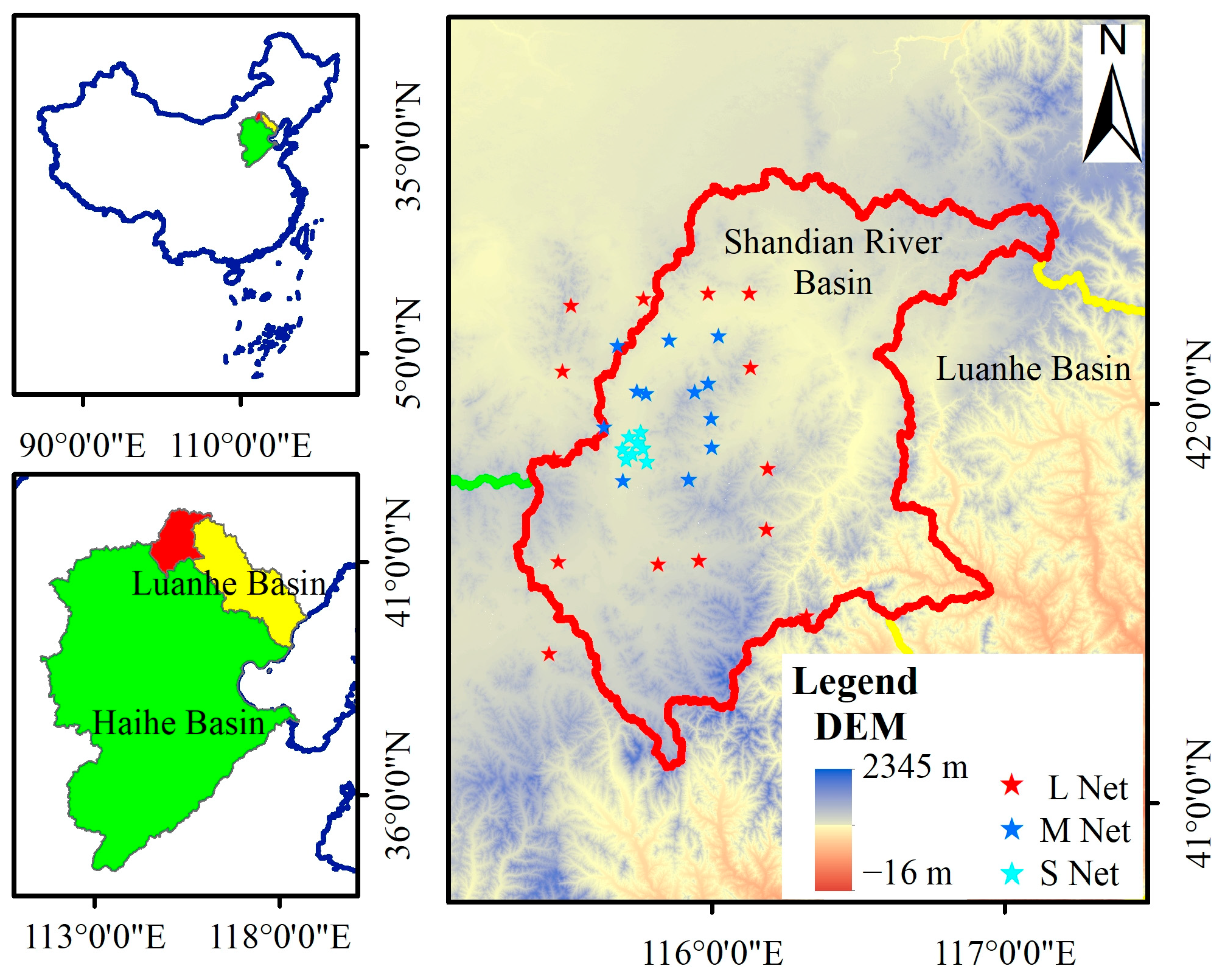
Figure 1. Location of the Shandian River Basin.
Remotesensing 18 03048 g001
Figure 2. Data Processing Flowchart.
Remotesensing 18 03048 g002
Figure 3. Soil moisture inversion method flowchart.
Remotesensing 18 03048 g003
Figure 4. Schematic diagram of forward simulation of land surface brightness temperature.
Remotesensing 18 03048 g004
Figure 5. Flowchart of Model Parameter Determination.
Remotesensing 18 03048 g005
Figure 6. Schematic diagram of the optimization framework for soil moisture retrieval.
Remotesensing 18 03048 g006
Figure 7. Seasonal average results of soil moisture retrieval in the Shandian River Basin.
Remotesensing 18 03048 g007
Figure 8. Validation of different soil moisture retrieval methods using ground-based observations in the Shandian River Basin.
Remotesensing 18 03048 g008
Figure 9. Flowchart for validating the parameter estimation method.
Remotesensing 18 03048 g009
Figure 10. Accuracy comparison chart of the method under different parameter combinations (number of observations = 25).
Remotesensing 18 03048 g010
Figure 11. Monthly variation in model parameters in the Shandian River Basin.
Remotesensing 18 03048 g011
Figure 12. Comparison chart of different soil moisture inversion methods in Spring 2021.
Remotesensing 18 03048 g012
Figure 13. Comparison chart of different soil moisture inversion methods in Summer 2021.
Remotesensing 18 03048 g013
Figure 14. Comparison chart of different soil moisture inversion methods in Autumn 2021.
Remotesensing 18 03048 g014
Figure 15. Comparison chart of different soil moisture inversion methods in Winter 2021.
Remotesensing 18 03048 g015
Figure 16. Spatial distribution of the dominant land cover type and corresponding fractional coverage in Shandian River Basin.
Remotesensing 18 03048 g016
Figure 17. Spatial Distribution of Mean Daily Precipitation in Each Season over the Shandian River Basin in 2021.
Remotesensing 18 03048 g017
Table 1. Hp roughness effect analysis model empirical parameters.
Parameter Name a 1 a 2 a 3
A 1 , H 0.068502−0.0584860.976321
A 2 , H −0.0513770.0149780.045456
A 3 , H 0.601618−0.151848−0.607679
A 1 , V 0.296412−0.1690750.993309
A 2 , V −0.049491−0.0122770.048694
A 3 , V 0.552790.086331−0.636948
Table 2. Range of variation in forward model parameters.
Parmeter NameRange of VariationStep Length
Surface temperature[245K, 314K]1K
Soil dielectric constant[3, 60]1
Incident[39°, 41°]0.5°
Vegetation optical depth[0, 1.5]0.02
Soil surface roughness[0, 4.5]0.1
Single-scattering albedo[0, 0.2]0.01
Table 3. Soil moisture retrieval accuracy validation indicators under collocated samples.
MethodYearNRMSEubRMSEMREBais
This method20192030.05620.03860.2827−0.0409
MCCA20192030.06500.04060.3258−0.0507
DCA20192030.08450.04910.4298−0.0687
SCA-H20192030.10280.05090.5428−0.0893
SCA-V20192030.08280.04840.4232−0.0672
This method20202400.06370.04440.2996−0.0457
MCCA20202400.06500.04590.3004−0.0460
DCA20202400.08270.05200.4022−0.0643
SCA-H20202400.10180.05440.5152−0.0860
SCA-V20202400.08170.05210.3994−0.0629
This method20212470.08140.04880.3323−0.0651
MCCA20212470.08400.04750.3432−0.0692
DCA20212470.10020.05640.4084−0.0828
SCA-H20212470.12120.0590.4962−0.1058
SCA-V20212470.09940.05650.4038−0.0818
This method20221930.07050.05050.3133−0.0491
MCCA20221930.07480.05100.3347−0.0547
DCA20221930.09390.05850.4451−0.0735
SCA-H20221930.11360.06040.5544−0.0962
SCA-V20221930.09290.05750.4352−0.0729
This method20232330.05410.05040.2800−0.0196
MCCA20232330.05430.04750.2868−0.0264
DCA20232330.07220.05460.4222−0.0473
SCA-H20232330.08900.05670.5401−0.0686
SCA-V20232330.07080.05440.4095−0.0453
This method2024950.08470.06250.3846−0.0572
MCCA2024950.08470.05740.3936−0.0624
DCA2024950.10390.06470.4763−0.0813
SCA-H2024950.12590.05910.5874−0.1112
SCA-V2024950.10300.05820.4755−0.0850
This methodAll12110.06780.05050.3085−0.0453
MCCAAll12110.07070.04960.3235−0.0504
DCAAll12110.08860.05650.4246−0.0683
SCA-HAll12110.10790.05820.5326−0.0908
SCA-VAll12110.08750.05580.4179−0.0674
Table 4. Parameter estimation accuracy under different numbers of observations.
Parameter Name r o u ω
RMSEMRERMSEMRE
5 observations0.56890.25500.00790.0725
10 observations0.40060.16380.00370.0325
15 observations0.29430.11870.00260.0196
20 observations0.25410.10030.00210.0136
25 observations0.21470.08630.00150.0071
30 observations0.20050.07850.00130.0060
Disclaimer/Publisher’s Note: The statements, opinions and data contained in all publications are solely those of the individual author(s) and contributor(s) and not of MDPI and/or the editor(s). MDPI and/or the editor(s) disclaim responsibility for any injury to people or property resulting from any ideas, methods, instructions or products referred to in the content.