Data Descriptor

OPMS-Seg: A UAV-Based High-Resolution Image Dataset for Semantic Segmentation of Open-Pit Coal Mine Slopes


1
College of Safety and Emergency Management and Engineering, Taiyuan University of Technology, Taiyuan 030024, China
2
Shanxi Province Engineering Research Center of Coal Mine Intelligent Equipment, Taiyuan University of Technology, Taiyuan 030024, China
3
Xinjiang Intelligent Equipment Research Institute, Aksu 843000, China
4
State Key Laboratory of Intelligent Mining Equipment Technology, Taiyuan 030032, China
5
College of Mining Engineering, Taiyuan University of Technology, Taiyuan 030024, China
6
Xinjiang Tianchi Energy Co., Ltd., Changji 831100, China
*
Author to whom correspondence should be addressed.
Remote Sens. 2026, 18(18), 3094; https://doi.org/10.3390/rs18183094
Submission received: 3 July 2026 / Revised: 29 August 2026 / Accepted: 8 September 2026 / Published: 9 September 2026
(This article belongs to the Section Earth Observation Data)

Highlights

What are the main findings?
  • We present OPMS-Seg, the first publicly available benchmark dataset for pixel-level semantic segmentation of open-pit coal mine slopes, comprising 2814 high-resolution UAV images and 15,334 polygon-based instances.
  • The dataset covers four geometric slope types (Backlight, Stepped, Rubble, and Bottom types) and provides three common annotation formats (COCO JSON, YOLO TXT, and binary PNG masks) to support a wide range of segmentation models.
What are the implications of the main findings?
  • OPMS-Seg fills the critical data gap in open-pit mine slope perception, enabling reproducible benchmarking and accelerating the development of vision-based intelligent monitoring and early deformation warning systems.
  • The dataset’s multi-format release and validated annotation quality (Cohen’s κ = 0.89, mIoU = 0.89) offer a solid foundation for future research in slope contour extraction, time-series deformation analysis, and transfer learning for mining safety applications.

Abstract

Landslides induced by slope deformation in open-pit coal mines pose significant risks to personnel safety and production continuity. Intelligent slope recognition is a prerequisite for early deformation warning, yet no publicly available segmentation dataset specifically targeting open-pit mine slopes currently exists, hindering progress in vision-based monitoring. To address this gap, we present OPMS-Seg, a benchmark dataset for semantic segmentation of open-pit mine slopes. The dataset contains 2814 UAV-captured RGB images and 15,334 polygon instances, covering four geometric slope types (Backlight, Stepped, Rubble, and Bottom types). Annotation files are provided in COCO (JSON), YOLO (TXT), and binary mask (PNG) formats to support diverse segmentation models. All annotations were validated by mining engineering experts. The dataset supports two segmentation tasks: (1) binary segmentation (slope vs. background) and (2) four-class fine-grained segmentation (distinguishing the four slope geometry types). In this paper, we present baseline results for the binary segmentation task, while the four-class task is provided as a benchmark for future research. We evaluated four classic models—U-Net, DeepLabV3+, YOLOv5-Seg, and YOLOv11-Seg—on OPMS-Seg, achieving strong performance and confirming annotation accuracy and scene representativeness. This open-access dataset is intended to accelerate intelligent monitoring, algorithm benchmarking, and low-altitude remote sensing tasks in open-pit environments.

1. Introduction

1.1. Background

With the ongoing expansion of the global economy, national and industrial energy demands continue to rise. Although the share of emerging energy sources within the global energy supply system has been increasing year by year, conventional fossil fuels remain dominant, with coal exploitation providing a primary energy supply across sectors [1]. According to extraction method, coal mining is generally categorized into open-pit and underground (shaft) mining. Open-pit mining accesses coal seams by successive removal of overburden; despite offering a more open operational environment than underground mining, the stepped, artificially steep slopes formed by repeated stripping and extraction are commonly composed of heterogeneous materials such as topsoil and rock. Under prolonged large-scale, high-intensity extraction activities and infiltration from precipitation, these slopes are highly susceptible to landslides, collapses, and other slope failures, which directly threaten on-site production equipment and personnel. Consequently, deformation monitoring of open-pit mine slopes has become a core component for ensuring extraction safety and maintaining production continuity, and its importance spans the entire life cycle of an open-pit mine.
Achieving intelligent monitoring of open-pit slopes first requires resolving the problem of high-precision visual perception within slope regions. Semantic segmentation techniques enable automatic delineation of slope contours, forming a foundation for subsequent deformation analysis aimed at early disaster forecasting, protection of personnel and equipment, optimization of mining design, and ultimately safe and efficient mine operations. With rapid advances in machine vision, image data-driven environmental perception for mining has emerged as a focal research area. In recent years, numerous scholars and practitioners have conducted in-depth studies of image segmentation algorithms across multiple open-pit mine safety monitoring scenarios and have reported substantial results. In blasting contexts, image segmentation algorithms have been applied to measurement and image analysis of the three-dimensional surface contours of blasted rock heaps [2,3]. In autonomous driving scenarios, segmentation supports identification of passable mine roads and small obstacles from the driver’s viewpoint, facilitating development of unmanned driving algorithms [4,5]. For surface information acquisition, segmentation methods enable investigation and monitoring of various land-occupation issues arising from open-pit mining activities [6]. Regarding slope rock mass characterization, these algorithms can detect weak structural planes [7], rock texture [8], and zones of change [9]. The aforementioned studies underscore the applicability of machine vision-based image segmentation to slope safety inspection; the successful deployment of models such as DeepLabV3+, U-Net, and YOLO-Seg further attests to the suitability of image segmentation algorithms for safety monitoring in open-pit mining environments.

1.2. Challenges and Data Gaps

As reviewed in Section 1.1, image segmentation algorithms have demonstrated strong potential in various open-pit mining safety scenarios. However, the development and benchmarking of such algorithms for slope-specific tasks are severely constrained by the lack of publicly available, pixel-level annotated datasets. This data gap constitutes the primary motivation for constructing OPMS-Seg.
High-quality image datasets have driven innovation and optimization of AI algorithms by providing standardized benchmark images and realistic scenarios, thereby offering strong data support for solving domain-specific problems. In recent years, computer vision datasets such as PASCAL VOC [10], ImageNet [11], Open Images [12], and COCO [13]—which cover common objects in daily life, including animals, vehicles, and furniture, as well as ports, bridges, aircraft, and ships—have played a critical role in visual tasks such as object detection and image segmentation in general scenes. Similarly, in various industrial domains, there exist mature open-source image datasets; for example, MLRSNet [14] in remote sensing, MIM4D [15] for autonomous driving, RiceSEG [16] in agriculture, and PRAD-CyC [17] in medicine each play important roles within their respective application contexts. Besides these classical open datasets, private datasets can be constructed using image-annotation tools during model training; however, such datasets typically exhibit diverse annotation formats and poor shareability, limiting their capacity to robustly advance vision models for specialized scenarios.
The DsLMF+ [18] dataset, developed in 2023 by the Xi’an University of Science and Technology team, effectively filled a gap in coal-industry datasets. DsLMF+ contains imagery of common underground coal-mining equipment—such as hydraulic supports, protector plates, and large coal blocks—and comprises more than 138,000 COCO-format label files corresponding to original images. The open release of this dataset has greatly advanced the development and practical deployment of vision models for underground coal mines. Nevertheless, open-pit mining environments are more expansive and operationally complex, such that DsLMF+ is not readily applicable to vision-model development for open-pit mines. Publicly available datasets specific to open-pit mining currently include TPSet [19], DOWHM [20], MUSeg [21], and MineSeg [22]. Table 1 shows a comparison of typical datasets for open-pit mines.

1.3. Contributions of This Work

Under the harsh conditions characteristic of open-pit coal mines—strong illumination, dust interference, and complex slope surface textures—the performance of semantic segmentation models depends critically on large-scale, high-quality datasets with pixel-level annotations. At present, there is no publicly available image segmentation dataset specifically targeting open-pit mine slope regions, which impedes reproducibility, benchmarking, and progress in related research. To address this gap, we constructed and released OPMS-Seg, a benchmark semantic segmentation dataset for open-pit mine slopes. This dataset emphasizes fine-grained annotation of slope areas and does not directly label landslide or failure zones; rather, it provides foundational perceptual data to support slope morphology recognition, contour extraction, and subsequent temporal comparison and deformation analyses such as slope angle change detection.
OPMS-Seg offers the following distinctive contributions: (1) slope focus: whereas other datasets predominantly cover overall mine scenes or tailings storage facilities, this dataset specifically targets slope regions; (2) pixel-level annotation: it provides semantic masks instead of image-level labels or bounding boxes; (3) multi-format outputs: it supports COCO (JSON), YOLO (TXT), and Mask (PNG) formats simultaneously, lowering barriers to use; (4) inclusion of complex scree-type slopes: it covers fractured rock slope surfaces, increasing the dataset’s challenge and representativeness.
Building on an analysis of general-scene image dataset composition, we collected slope images via unmanned aerial vehicles (UAVs) and produced the OPMS-Seg open-pit mine slope segmentation dataset using the Labelme annotation tool. The dataset comprises 2814 images and 15,334 polygon instances, where the source images were selected from UAV safety-inspection videos taken at five different open-pit coal mines. To broaden the dataset’s applicability, we provide label conversion scripts that transform JSON-format annotations into TXT and Mask formats, enabling segmentation tasks on mainstream YOLO-Seg-series algorithms. In addition to these two label formats, researchers can employ conversion tools to generate custom formats to facilitate downstream development for instance segmentation, semantic segmentation, panoptic segmentation, and other algorithmic tasks.
OPMS-Seg documents various dynamics and details of open-pit coal mine slopes during mining operations and is of practical significance for slope segmentation, deformation monitoring, and stability assessment using vision algorithms. Analysis of segmentation outputs can enable intelligent detection and early warning of slope deformation, thereby enhancing overall safety and automation levels at open-pit mines. The dataset also contains common open-pit mine objects such as unmanned haul trucks, haul roads, coal piles, and wheel loaders; these objects are present in the images but are not annotated in the current release. Future versions may extend the annotated categories to support multi-task learning and further expand the dataset’s industrial applicability.

2. Methods

This section describes the construction process of the OPMS-Seg dataset, including an overview of the source regions, acquisition and preprocessing of slope images, pixel-level annotation, and dataset partitioning. The dataset preparation workflow is illustrated in Figure 1.

2.1. Study Area Overview

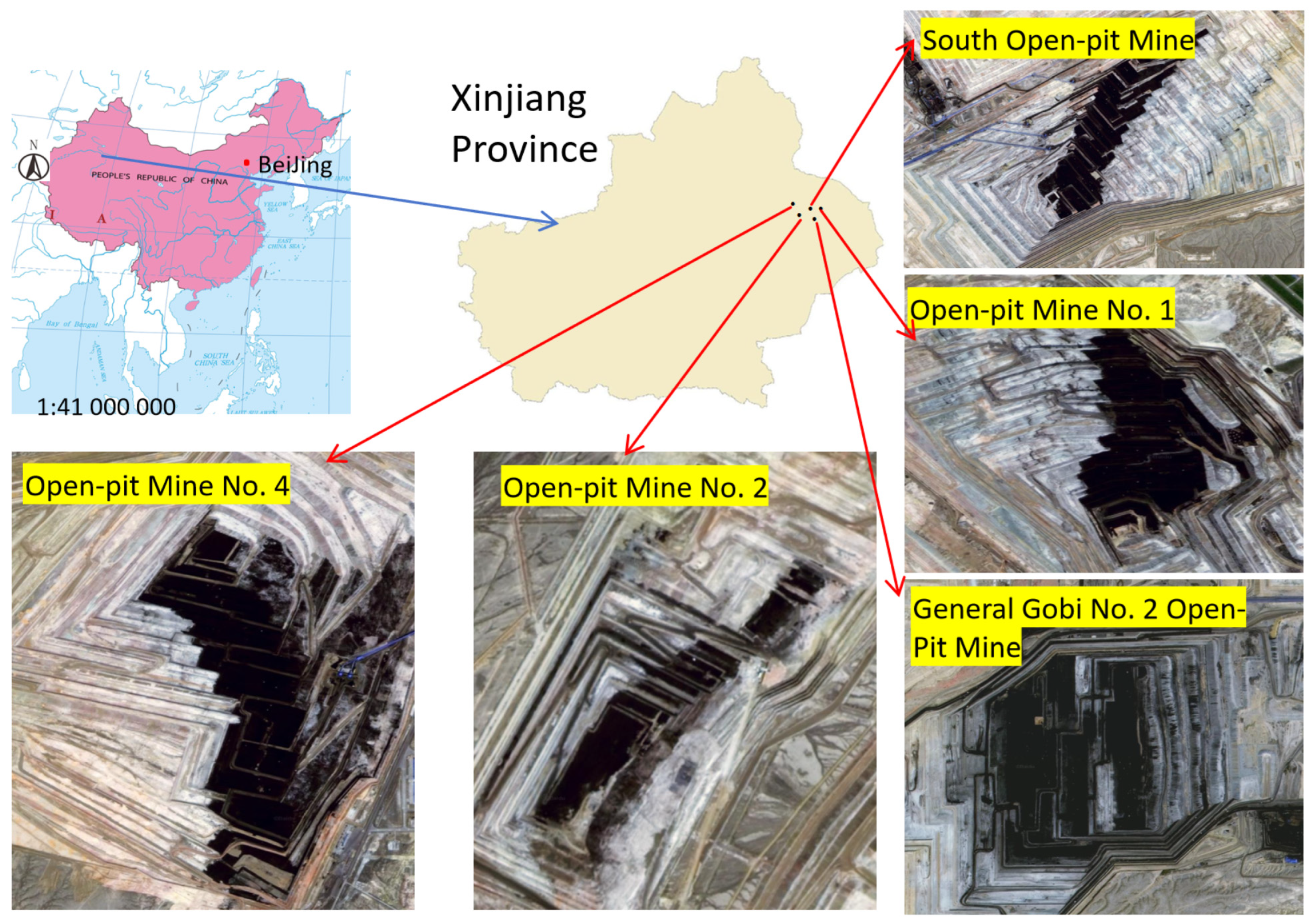
The study area covers five typical open-pit mines in the Zhundong coalfield (Xinjiang, China), located in a Gobi desert zone characterized by intense sunlight, large diurnal temperature variation, and frequent winds. These harsh conditions promote intense rock weathering and slope accidents, making the area highly representative for dataset construction. Basic information on the coal mines is summarized in Table 2.
The geographical distribution of the five selected open-pit coal mines is shown in Figure 2. These mines are located within the Zhundong coalfield (Xinjiang, China), spanning approximately 200 km from east to west and 150 km from north to south. The five mines exhibit notable differences in geomorphological characteristics: South Open-pit Mine and Open-pit Mine No. 1 are located in relatively flat Gobi desert terrain; Open-pit Mine No. 2 is situated near an ecological function zone with mild topographic undulations; Open-pit Mine No. 4 features moderate geological complexity with a thicker coal seam (average 46.79 m); and General Gobi No. 2 Open-pit Mine is located at the eastern edge of the coalfield with stable coal seam occurrence. The number of images collected from each mine ranges from 314 to 900, ensuring balanced coverage across different mining conditions. These five mines were selected because: (1) they represent the dominant mining scales (annual production: 2000–4000 × 104 t/a) in the Zhundong region; (2) they cover the full spectrum of geological complexity (simple, moderate, and complex) found in typical Xinjiang open-pit mines; and (3) they collectively exhibit the four major slope geometry types defined in Section 3.3, making them representative for constructing a generalizable slope segmentation benchmark.

2.2. Data Acquisition

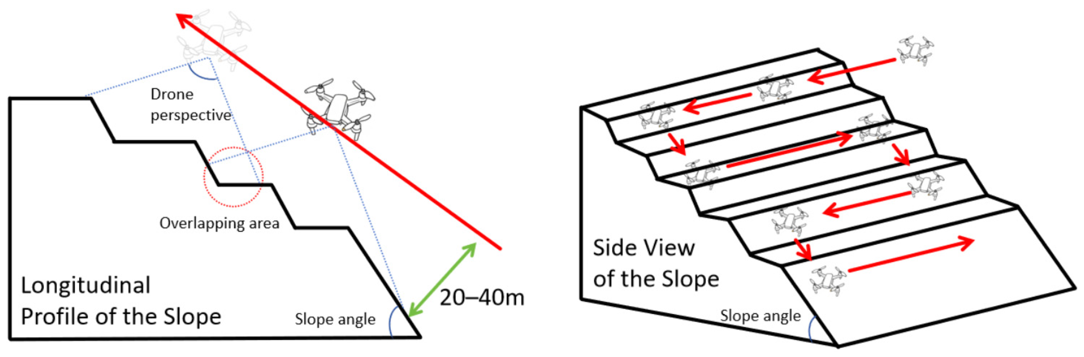
Given the safety risks of contact-based measurement and the need for cost-effective, high-frequency inspection, we employed oblique photogrammetry using a Huace BB4 Bumblebee UAV (Table 3). The UAV was configured to capture RGB video at 30 FPS (1920 × 1080 resolution) following a planned route: “surrounding all sides and gradually ascending step by step” (Figure 3). Manual mode was used for key areas (e.g., coal seam outcrops and gravel zones). Data collection occurred from May to October 2025, between 10:00 and 16:00 local time, under sunny or cloudy conditions, avoiding nighttime or rainy days. The captured 30 FPS videos were processed using a frame extraction interval of 10 frames to generate the raw image set. This interval was chosen to balance temporal coverage and data redundancy. A total of 3136 frames were initially extracted across all flight sorties. To further minimize duplication, we applied a deduplication strategy based on structural similarity (SSIM) between consecutive extracted frames. Specifically, if two consecutive frames exhibited an SSIM > 0.95, the later frame was discarded. Following this deduplication step, the initial frames were reduced to 2814 unique images.

2.3. Data Preprocessing

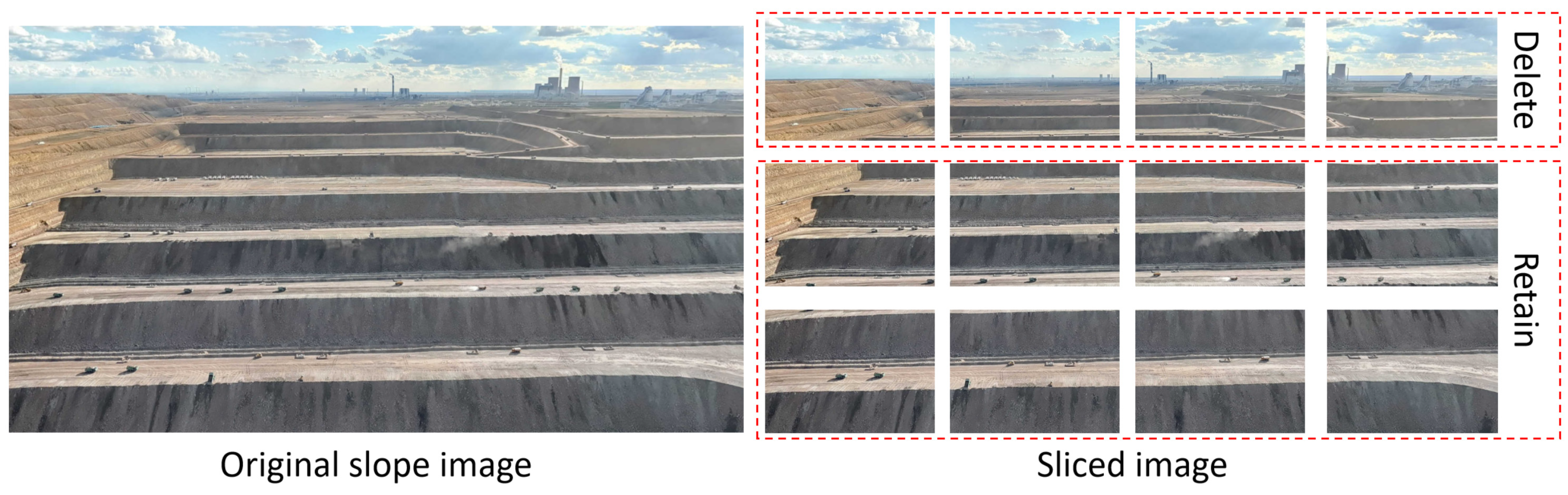
Raw UAV images are large and contain noise. We employed an equal-division cropping method (Figure 4) to split each 1920 × 1080 image into 12 sub-images of 477 × 328 pixels. This size ensures (1) complete divisibility from the original, (2) slope areas accounting for a suitable proportion for network input, and (3) compatibility with standard GPU memory. Subsequently, strict screening rules were applied to remove images where the slope proportion was <50%, images with motion blur/overexposure, repetitive content, and obstructed views. Following these criteria, 322 images were excluded, leaving 2814 valid images (Table 4).

2.4. Annotation Procedure

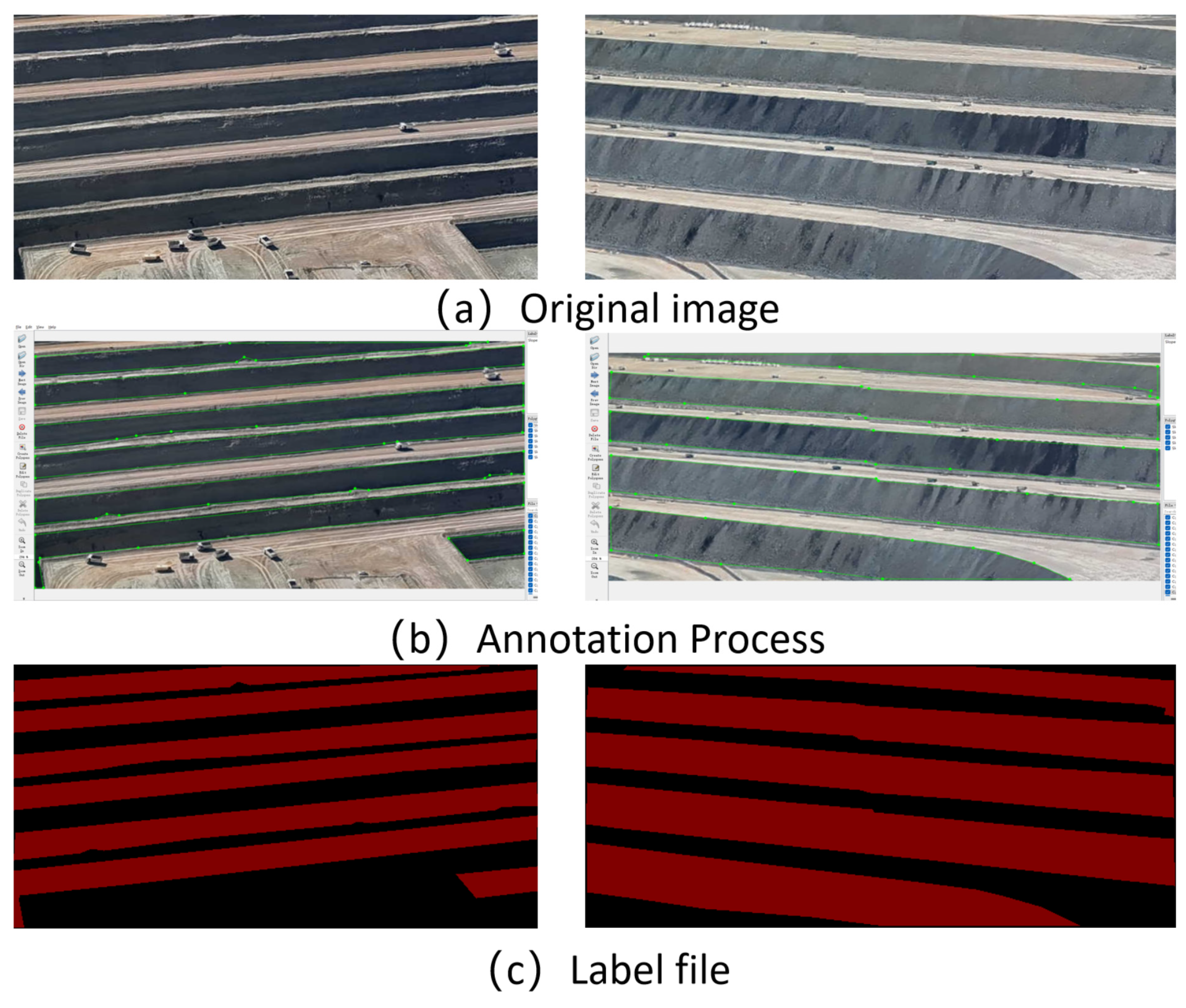
Pixel-level polygon annotation was conducted using Labelme software (version 3.16.2). A guidance group comprising university professors and mining experts trained all annotators. The annotation boundary was strictly defined: the upper boundary is the slope shoulder (edge of the haul road), and the lower boundary is the toe of the next bench. For the uppermost slope in an image, the upper boundary is defined as the visible crest line where the slope surface meets the top platform or haul road (Figure 5). For the lowermost slope, the lower boundary is defined as the visible toe line adjacent to the bottom bench or pit floor. In cases where the slope shoulder or toe is partially occluded by vegetation, equipment, or shadows, annotators delineated the boundary based on the nearest continuous visible morphological break, and such cases were flagged for expert review during the cross-check stage [23]. All non-slope areas were marked as “Background”. To ensure quality, a two-stage cross-check and three-expert review process was implemented; any discrepancies were resolved by re-annotation.
To quantitatively assess annotation consistency, we randomly selected 200 images (approximately 7% of the dataset) for independent re-annotation by three experts. The pairwise inter-annotator Agreement, measured by Cohen‘s Kappa coefficient, averaged 0.89 (range: 0.86–0.92), indicating strong agreement. The mean Intersection over Union (IoU) among annotators for the slope class was 0.91. These results confirm the high reliability and reproducibility of the labeling protocol.

2.5. Format Conversion

To enhance compatibility, we provide Python scripts (“OPMS-Seg Helper Program”) that convert the original JSON files into:
  • TXT format: For YOLOv5-Seg and YOLOv11-Seg.
  • PNG format: Binary masks (value 1 for slope, 0 for background) for DeepLabV3+ and U-Net.
These scripts are released alongside the dataset on Figshare.

3. Dataset Description

3.1. Dataset Overview

OPMS-Seg is hosted on Figshare and is freely available under the CC BY 4.0 license. It contains 2814 RGB images (1.39 GB compressed; 1.64 GB decompressed) and 15,334 polygon instances (average 5.45 instances per image). The 15,334 instances are stored across 2814 JSON files (Labelme format, one per image), 2814 TXT files (YOLO-Seg format), and 2814 PNG masks (binary format). Each image corresponds to exactly one annotation file in each format, and each annotation file contains one or more polygon instances. Table 5 provides a comprehensive summary of the dataset profile.

3.2. File Structure

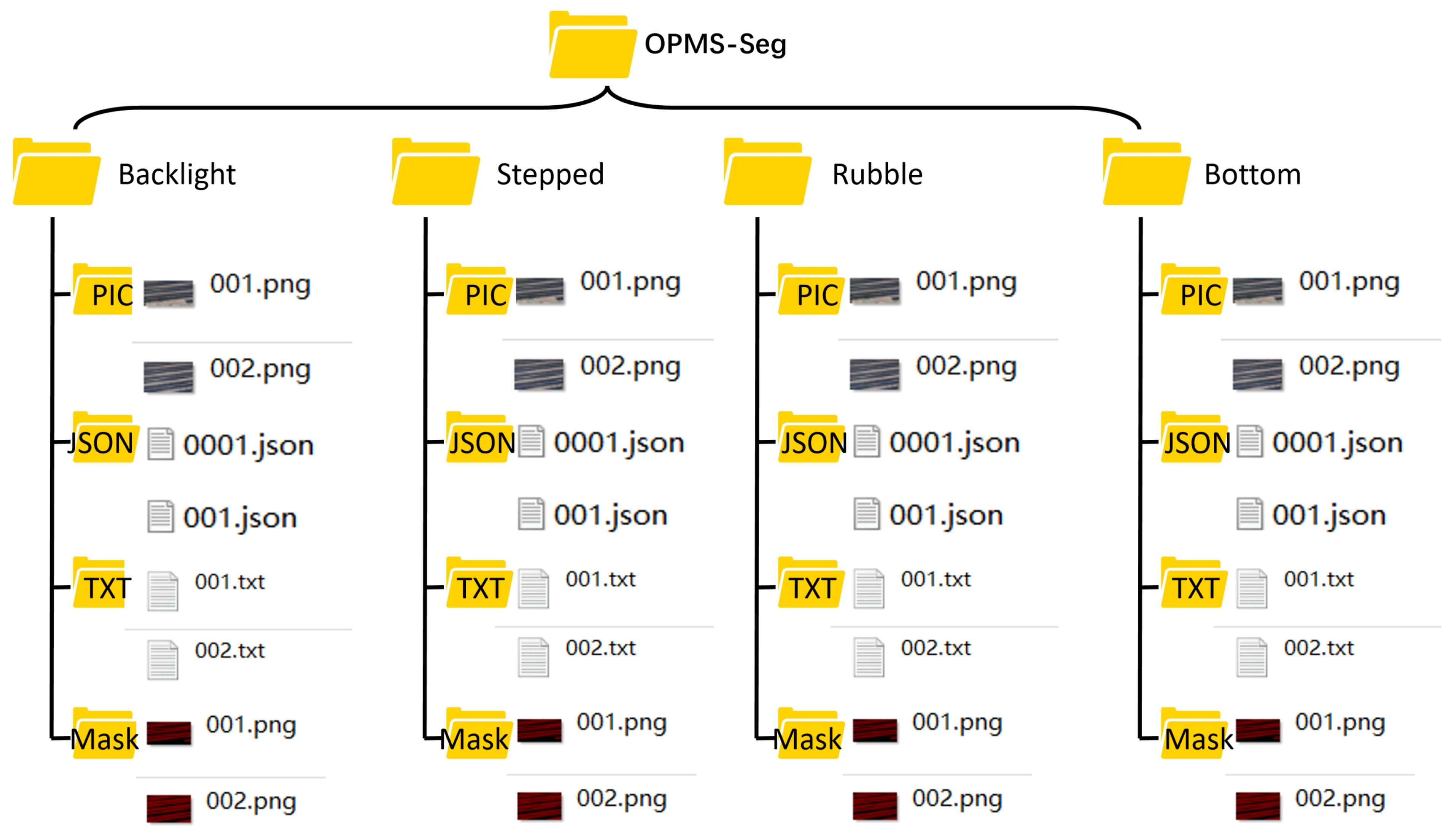
The dataset is organized into a clear directory structure for immediate usability (Figure 6). Under the root directory, four subdirectories are provided:
  • PIC/: Contains the original 477 × 328 pixel cropped images.
  • JSON/: Contains Labelme-generated JSON files (COCO format).
  • TXT/: Contains converted annotation files suitable for YOLO-series segmentation.
  • Mask/: Contains binary mask PNG files (pixel value 1 for slope) for DeepLab-series models.
All 2814 images are organized in the PIC/ directory. Each image is accompanied by one JSON file (JSON/), one TXT file (TXT/), and one PNG mask. Thus, the dataset contains 2814 JSON files, 2814 TXT files, and 2814 PNG masks, totaling 8442 annotation files. The 15,334 polygon instances are distributed across the 2814 JSON files, with an average of 5.45 instances per image (ranging from 1 to 14 instances per image, depending on the complexity of the slope scene).

3.3. Slope Type Definition and Classification

Based on macro-geometric shapes observed from UAV perspectives, the annotated slope areas are classified into four types (Table 6). This classification performs the semantic segmentation task of distinguishing forms, rather than determining stability. It is important to clarify that these four types serve two purposes: (1) as class labels for four-class semantic segmentation and (2) as a scene-level grouping scheme for dataset organization. In the current baseline experiments, we focus on the binary segmentation task (slope vs. background), as this is the most fundamental requirement for slope contour extraction. However, the four-class annotations are provided in the dataset to enable future research on fine-grained slope morphology classification. Researchers may choose to use either the binary masks (in the Mask/directory) or the four-class labels (encoded in the JSON and TXT files) depending on their task requirements.
The 50% threshold for slope area proportion was determined empirically based on preliminary experiments: when the slope region occupies less than 50% of the cropped image, the remaining area consists predominantly of sky, distant terrain, or haul roads, which contribute limited discriminative features for slope segmentation and may introduce class imbalance. This threshold ensures that each training sample contains sufficient slope pixels to enable effective feature learning, while still preserving contextual background information. A similar thresholding strategy has been adopted in prior mining-related datasets.

3.4. Dataset Partitioning

To ensure robust benchmarking while preventing data leakage, the 2814 images were split at the video-segment level rather than at the individual image level. Specifically, the UAV video recordings from each flight sortie were divided into 5-s segments. Frames were then extracted from each segment using a 10-frame interval. The extracted frames from each segment were assigned as a whole to either the training, validation, or test set, ensuring that images originating from the same video segment do not appear in more than one set.
The dataset was partitioned at the segment level using an 8:1:1 ratio, resulting in 2251 training, 282 validation, and 281 test images. The distribution across the five source mines is detailed in Table 7, ensuring proportional representation of each slope type. This video-segment-level split provides a more realistic assessment of model generalization to unseen flight missions and eliminates the risk of temporally correlated images contaminating the test set. The frame extraction interval and the SSIM-based deduplication strategy further ensure that the dataset contains minimal near-duplicate samples across the training and test splits.

3.5. Statistical Characteristics

The dataset captures significant variability in lighting conditions, ranging from strong direct sunlight to moderate overcast illumination. According to local meteorological records for the Zhundong region during the data acquisition period (May–October), the typical illuminance under clear-sky conditions ranges from 60,000 to 100,000 lux, which is representative of the harsh lighting environment in Gobi desert open-pit mines. Shadows are naturally present in the images and are retained to improve model robustness for real-world deployment. The image resolution (477 × 328) balances computational efficiency with feature representation, ensuring slope regions occupy approximately 30–70% of the image area.
The distribution of the 15,334 polygon instances across the four slope types is summarized in Table 8. As shown, the Stepped and Rubble types account for the largest shares, reflecting their prevalence in the five selected mining areas. The Backlight and Bottom types are relatively less frequent but still well represented. This distribution ensures that the dataset captures the full diversity of slope geometries while maintaining sufficient samples for each type to support effective model training and evaluation.

4. Technical Validation and User Notes

4.1. Dataset Positioning and Applicable Boundaries

It is critical to emphasize that OPMS-Seg annotates the geometric surface area of slopes (Backlight, Stepped, Rubble, Bottom) rather than directly labeling landslide zones, fractures, or unstable regions. Therefore, models trained on this dataset output slope contour and region extraction, not stability assessment conclusions.
However, this dataset serves as a robust foundation for secondary high-level applications, including:
(1)
Deformation trend inference: Comparing slope top-line position changes in time-series segmentation results.
(2)
Multi-task learning: Expanding labels to include mining trucks, roads, or coal piles.
(3)
Transfer learning benchmarks: Fine-tuning pre-trained models for mining-specific contexts.
(4)
Geological logging: Automating slope morphology identification.
We encourage researchers to build upon this dataset by adding fine-grained labels for cracks, rockfall areas, and support structures in future versions.

4.2. Experimental Setup

To validate the dataset’s usability, we benchmarked four classic segmentation models: U-Net, DeepLabV3+, YOLOv5-Seg, and YOLOv11-Seg. All experiments were conducted on Windows 11 (NVIDIA Tesla V100 32G). The software dependencies for each model are listed in Table 9. All models were trained for 300 epochs with default hyperparameters, except for minor adjustments to adapt to the dataset.
Due to the limited GPU memory (NVIDIA Quadro P620, 2GB), we adopted gradient accumulation and mixed-precision training where applicable. Specifically, U-Net and DeepLabV3+ were trained with a batch size of 4 and gradient accumulation steps of 2 (effective batch size = 8). YOLOv5-Seg and YOLOv11-Seg were trained with a batch size of 8. All models were trained for 300 epochs; the total training time was approximately 72 h for U-Net, 96 h for DeepLabV3+, and 48 h for each YOLO-Seg model.
Input images were resized to 480 × 320 for U-Net and DeepLabV3+, and to 640 × 640 for YOLO-series models, to fit the model requirements and memory constraints. We acknowledge that this resolution discrepancy may affect the fairness of cross-model comparison, as lower input resolution can intrinsically handicap dense prediction architectures like DeepLabV3+ [24]. Specifically, He et al. demonstrated that reducing feature map resolution via subsampling operations dramatically decreases estimation accuracy in semantic segmentation tasks. To mitigate this limitation, we applied the same data augmentation strategy, training epochs, and dataset partitioning to all models. Future work with larger GPU memory will adopt a unified input resolution to enable more equitable comparisons. We have explicitly noted this as a limitation in Section 4.5.

4.3. Evaluation Metrics

We adopted the mean Intersection over Union (mIoU) and mean Pixel Accuracy (mPA) as evaluation metrics, focusing on the binary classification task (slope vs. background) in the current baseline experiments. The binary masks (PNG format) in the Mask/ directory provide pixel value 1 for all slope areas (regardless of type) and 0 for background. For researchers interested in the four-class segmentation task, the JSON and TXT files contain type-specific labels, and the evaluation can be extended accordingly. mIoU is defined as
mIoU = 1 k + 1 i = 0 k T P i T P i + F P i + T N i
where T P i , F P i and F N i denote true positives, false positives, and false negatives for class ii, and NN is the number of classes (here, k = 1: slope). mPA is defined as
mPA = 1 N i = 1 N T P i T P + F P i i
Precision measures the proportion of predicted slope pixels that are correct; Recall measures the proportion of actual slope pixels that are correctly identified; F1-score is the harmonic mean of Precision and Recall; and Boundary IoU evaluates the segmentation accuracy along the slope contour boundaries. These metrics are defined as
Precision = T P T P + F P
Recall = T P T P + F N
F 1 = 2 × 1 N Precision Recall Precision + Recall
Boundry   IoU = B p r e d B g t B p r e d B g t
where B p r e d and B g t denote the boundary pixels of the predicted and ground-truth masks.

4.4. Baseline Results

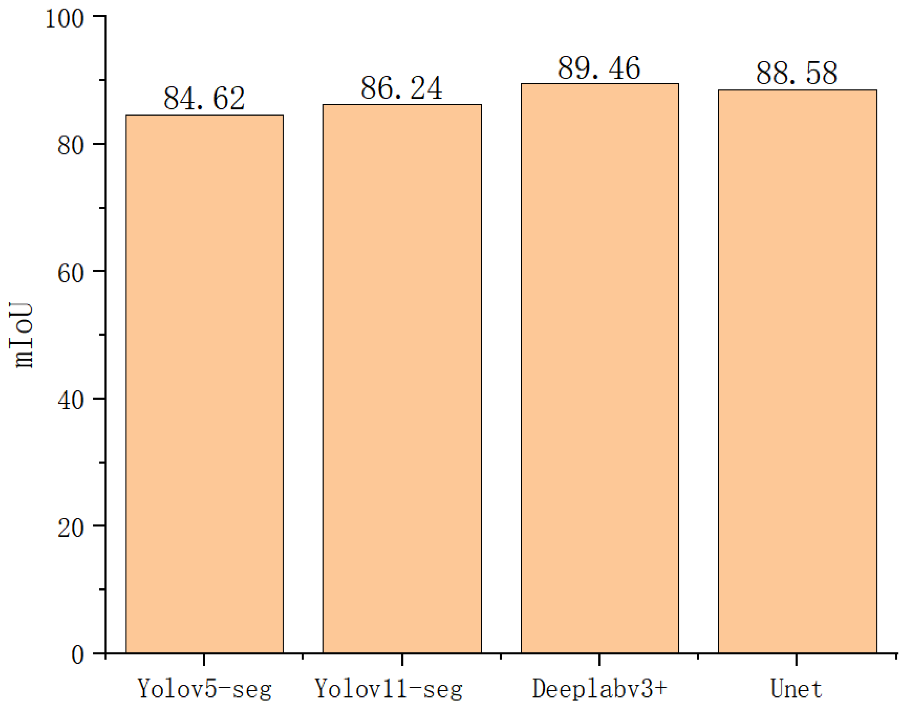
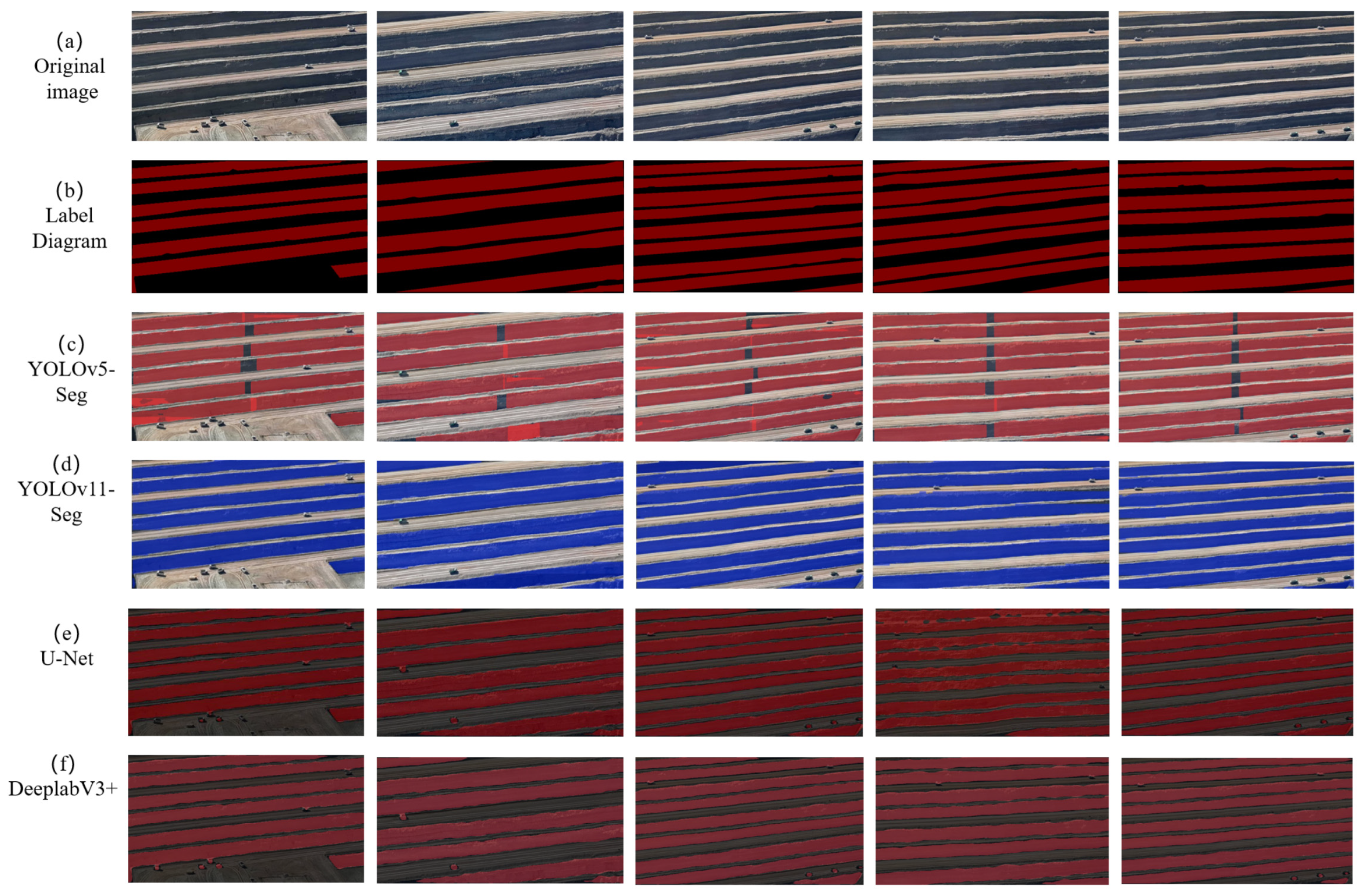
All four models were retrained on the video-segment-level split to prevent data leakage. The updated mIoU results are shown in Figure 7, and visual segmentation results are presented in Figure 8.
Importantly, under the original random image-level split, DeepLabV3+ achieved an mIoU of 97.4%, which substantially exceeded the inter-annotator agreement upper bound (IoU = 0.91)—a strong indication of data leakage. After adopting the video-segment-level split, the new mIoU for DeepLabV3+ is 89.46%, which is now consistent with the human annotation consistency upper bound (Table 10). This confirms that the previous high performance was partly attributable to data leakage, and the new results provide a more realistic and trustworthy benchmark for future algorithm comparison.
All four models still achieve strong segmentation performance under the corrected split, confirming the high quality and consistency of the annotations. The results demonstrate that OPMS-Seg is a challenging yet solvable benchmark suitable for evaluating semantic segmentation algorithms in open-pit mining environments.

4.5. Limitations and Future Work

We acknowledge the following limitations:
  • Geographic Coverage: The dataset was collected solely from the Gobi desert region of Xinjiang, China. It does not include forest-covered, high-altitude permafrost, or humid tropical slope scenes. Users applying the model to other climate zones should consider domain adaptation.
  • Shadows: We did not actively remove shadows, as they are inherent features; however, users may employ histogram equalization or Retinex-based methods if needed.
  • Hardware Constraints and Resolution Discrepancy: Due to the limited GPU memory, U-Net and DeepLabV3+ were trained at 480 × 320, while YOLO-series models used 640 × 640. As demonstrated by He et al. [24], lower input resolution can disadvantage dense prediction architectures in cross-model comparisons. Future work with larger GPU memory will adopt a unified resolution for fairer benchmarking.
  • Categories: Currently only slopes are annotated. Future versions will include labels for haul trucks, roads, and coal stockpiles to support broader multi-task learning.
  • Screening Threshold and Occlusion Handling: The 50% slope-area threshold effectively filters out irrelevant backgrounds but may introduce a selection bias against smaller or distant slope benches. Additionally, when slope boundaries were partially occluded by vegetation or equipment, annotators used the nearest visible morphological break, which may introduce subjective labeling noise in heavily occluded regions. Future work will explore boundary-aware loss functions to enhance mask edge precision.
Despite these limitations, OPMS-Seg provides a foundational data resource for slope morphology recognition and contour extraction. We envision that future expansions—including annotations for haul trucks, haul roads, coal stockpiles, and cracks—will enable multi-task learning and broader industrial applicability. We invite the community to build upon this dataset to advance high-precision perception in complex mining environments.

5. Conclusions

This paper presents OPMS-Seg, a benchmark dataset for pixel-level semantic segmentation of open-pit coal mine slopes. The dataset comprises 2814 high-resolution UAV-captured RGB images and 15,334 polygon-based annotations, covering four geometric slope types (Backlight, Stepped, Rubble, and Bottom types) collected from five representative open-pit mines in the Zhundong coalfield, Xinjiang, China. Annotations are provided in three common formats (COCO JSON, YOLO TXT, and binary PNG masks) to maximize interoperability across different segmentation frameworks.
The dataset is intended to support the following primary applications: (1) benchmarking of semantic segmentation algorithms for slope region extraction; (2) slope contour detection as a prerequisite for time-series deformation monitoring; (3) transfer learning and domain adaptation studies in mining environments; and (4) multi-task learning when combined with additional annotations for haul roads, vehicles, and coal piles in future releases.
We validated the dataset by benchmarking four classic segmentation models (U-Net, DeepLabV3+, YOLOv5-Seg, and YOLOv11-Seg), all of which achieved strong performance, confirming the high quality and consistency of the annotations.
It is important to clarify that OPMS-Seg directly supports slope recognition and contour extraction, rather than slope deformation monitoring, stability assessment, or hazard early warning. The current release provides foundational perceptual data for these higher-level tasks, which require additional temporal analysis, geological interpretation, and integration with other sensor modalities. We encourage researchers to use OPMS-Seg as a building block for developing robust vision-based monitoring systems in open-pit mining contexts.

Author Contributions

Conceptualization, Z.J. and H.W. (Hongwei Wang); methodology, L.S. and Y.G.; software, L.S.; validation, H.W. (Haoran Wang) and L.S.; formal analysis, Z.J.; investigation, Z.Y., G.H. and G.L.; resources, Y.G. and H.W. (Hongwei Wang); data curation, L.S. and Y.G.; writing—original draft preparation, L.S.; writing—review and editing, all authors; visualization, L.S.; supervision, Y.G.; project administration, H.W. (Haoran Wang); funding acquisition, Y.G. All authors have read and agreed to the published version of the manuscript.

Funding

This research was funded by the Major Science and Technology Special Project of Xinjiang Uygur Autonomous Region, grant number 2024A01003-2; and the Fundamental Research Program of Shanxi Province (Free Exploration), grant numbers 202403011242001 and 202303021212074.

Data Availability Statement

The OPMS-Seg dataset presented in this study is openly available on FigShare at: https://doi.org/10.6084/m9.figshare.31674361 (accessed on 7 September 2026). The dataset is published under the Creative Commons Attribution 4.0 International License (CC BY 4.0). The Figshare page will be updated at that time with the complete dataset title, author list, version number, keywords, description, funding information, file inventory, checksums, and license details. A properly formatted data citation will be included in the reference list of the final published version. Additionally, the supporting scripts for image cropping, file renaming, and format conversion (OPMS-Seg Helper Program) are released alongside the dataset. The open-source code used for benchmarking (DeepLabV3+, YOLOv5-Seg, and YOLOv11-Seg) is referenced in the manuscript and available via their respective public repositories.

Acknowledgments

The authors gratefully acknowledge Tianchi Energy South Open-pit Mine and other collaborating coal enterprises for providing site access and equipment support. We also extend our sincere thanks to the annotation team, reviewing experts, and instructors who contributed to the quality control process. During the preparation of this manuscript, the authors used DeepSeek-V3 (DeepSeek, 2025 version) to translate the original Chinese draft into English and to polish the language, including grammar corrections, sentence refinement, and terminology standardisation. All authors have carefully reviewed and edited the AI-generated output and take full responsibility for the scientific content and final expression of this publication.

Conflicts of Interest

Zhiyong Yang, Guilin Hu, and Guangxu Luo are employed by Xinjiang Tianchi Energy Co., Ltd. The remaining authors declare that the research was conducted in the absence of any commercial or financial relationships that could be construed as a potential conflict of interest.

References

  1. Teng, J.-W.; Qiao, Y.-H.; Song, P.-H. Analysis of exploration, potential reserves and high efficient utilization of coal in China. Chin. J. Geophys. 2016, 59, 4633–4653. [Google Scholar] [CrossRef]
  2. Thurley, M.J. Automated Image Segmentation and Analysis of Rock Piles in an Open-Pit Mine. In Proceedings of the 2013 International Conference on Digital Image Computing: Techniques and Applications (DICTA), Hobart, TAS, Australia, 26–28 November 2013; IEEE: Piscataway, NJ, USA, 2013; pp. 1–8. [Google Scholar]
  3. Liu, Y.; Li, C.; Huang, J.; Gao, M. MineSDS: A Unified Framework for Small Object Detection and Drivable Area Segmentation for Open-Pit Mining Scenario. Sensors 2023, 23, 5977. [Google Scholar] [CrossRef] [Scilit] [PubMed]
  4. Zheng, C.; Liu, L.; Meng, Y.; Wang, M.; Jiang, X. Passable Area Segmentation for Open-Pit Mine Road from Vehicle Perspective. Eng. Appl. Artif. Intell. 2024, 129, 107610. [Google Scholar] [CrossRef] [Scilit]
  5. Wang, Y.-J.; Cao, Z.; Tan, Q.-W. GPR detection of open-pit landslide. J. China Coal Soc. 2011, 36, 1093–1097. [Google Scholar]
  6. Yu, X.; Zhang, K.; Zhang, Y. Land Use Classification of Open-Pit Mine Based on Multi-Scale Segmentation and Random Forest Model. PLoS ONE 2022, 17, e0263870. [Google Scholar] [CrossRef] [Scilit] [PubMed]
  7. Niu, W.-J.; Chen, Y.-X.; He, B.-G.; Chen, G.-M.; Qiu, Z.-H.; Fan, W.-Y. Intelligent veins recognition method for slope rock mass geological images in complex background noise. Comput. Geosci. 2025, 197, 105885. [Google Scholar] [CrossRef] [Scilit]
  8. Li, L.; Li, Y.; Ai, Y.; Tian, B.; Xuanyuan, Z.; Chen, L. SegMine: A Multi-Modal Segmentation Dataset and Benchmarks for Visual Understanding in Open-Pit Mines. In Proceedings of the 2025 IEEE 28th International Conference on Intelligent Transportation Systems (ITSC), Gold Coast, Australia, 18–21 November 2025; IEEE: Piscataway, NJ, USA, 2025; pp. 2112–2119. [Google Scholar]
  9. Xiao, D.; Yin, L.; Fu, Y. Open-Pit Mine Road Extraction From High-Resolution Remote Sensing Images Using RATT-UNet. IEEE Geosci. Remote Sens. Lett. 2022, 19, 3002205. [Google Scholar] [CrossRef] [Scilit]
  10. Everingham, M.; Eslami, S.M.A.; Van Gool, L.; Williams, C.K.I.; Winn, J.; Zisserman, A. The Pascal Visual Object Classes Challenge: A Retrospective. Int. J. Comput. Vis. 2015, 111, 98–136. [Google Scholar] [CrossRef] [Scilit]
  11. Deng, J.; Dong, W.; Socher, R.; Li, L.-J.; Li, K.; Fei-Fei, L. ImageNet: A Large-Scale Hierarchical Image Database. In Proceedings of the 2009 IEEE Conference on Computer Vision and Pattern Recognition, Miami, FL, USA, 20–25 June 2009. [Google Scholar]
  12. Kuznetsova, A.; Rom, H.; Alldrin, N.; Uijlings, J.; Krasin, I.; Pont-Tuset, J.; Kamali, S.; Popov, S.; Malloci, M.; Kolesnikov, A.; et al. The Open Images Dataset V4: Unified Image Classification, Object Detection, and Visual Relationship Detection at Scale. Int. J. Comput. Vis. 2020, 128, 1956–1981. [Google Scholar] [CrossRef] [Scilit]
  13. Lin, T.-Y.; Maire, M.; Belongie, S.; Hays, J.; Perona, P.; Ramanan, D.; Dollár, P.; Zitnick, C.L. Microsoft COCO: Common Objects in Context. In Computer Vision–ECCV 2014; Fleet, D., Pajdla, T., Schiele, B., Tuytelaars, T., Eds.; Lecture Notes in Computer Science; Springer International Publishing: Cham, Switzerland, 2014; Volume 8693, pp. 740–755. ISBN 978-3-319-10601-4. [Google Scholar]
  14. Qi, X.; Zhu, P.; Wang, Y.; Zhang, L.; Peng, J.; Wu, M.; Chen, J.; Zhao, X.; Zang, N.; Mathiopoulos, P.T. MLRSNet: A Multi-Label High Spatial Resolution Remote Sensing Dataset for Semantic Scene Understanding. ISPRS J. Photogramm. Remote Sens. 2020, 169, 337–350. [Google Scholar] [CrossRef] [Scilit]
  15. Zou, J.; Liao, B.; Zhang, Q.; Liu, W.; Wang, X. MIM4D: Masked Modeling with Multi-View Video for Autonomous Driving Representation Learning. Int. J. Comput. Vis. 2025, 133, 6074–6087. [Google Scholar] [CrossRef] [Scilit]
  16. Zhou, J.; Wang, H.; Kato, Y.; Nampally, T.; Rajalakshmi, P.; Balram, M.; Katsura, K.; Lu, H.; Mu, Y.; Yang, W.; et al. Global rice multiclass segmentation dataset (RiceSEG): Comprehensive and diverse high-resolution RGB-annotated images for the development and benchmarking of rice segmentation algorithms. Plant Phenomics 2025, 7, 100099. [Google Scholar] [CrossRef] [Scilit] [PubMed]
  17. Wang, K.; Ait-Ahmad, K.; Kupp, S.; Sims, Z.; Cramer, E.; Sayar, Z.; Yu, J.; Wong, M.H.; Mills, G.B.; Eksi, S.E.; et al. UniFORM: Towards Universal ImmunoFluorescence Normalization for Multiplex Tissue Imaging. bioRxiv 2025. [Google Scholar] [CrossRef] [Scilit] [PubMed]
  18. Yang, W.; Zhang, X.; Ma, B.; Wang, Y.; Wu, Y.; Yan, J.; Liu, Y.; Zhang, C.; Wan, J.; Wang, Y.; et al. An open dataset for intelligent recognition and classification of abnormal condition in longwall mining. Sci. Data 2023, 10, 416. [Google Scholar] [CrossRef] [Scilit] [PubMed]
  19. Zhang, C.; Xing, J.; Li, J.; Du, S.; Qin, Q. A New Method for the Extraction of Tailing Ponds from Very High-Resolution Remotely Sensed Images: PSVED. Int. J. Digit. Earth 2023, 16, 2681–2703. [Google Scholar] [CrossRef] [Scilit]
  20. Zhang, X.; Chen, Y.; Han, W.; Chen, X.; Wang, S. Fine Mapping of Hubei Open Pit Mines via a Multi-Branch Global–Local-Feature-Based ConvFormer and a High-Resolution Benchmark. Int. J. Appl. Earth Obs. Geoinf. 2024, 133, 104111. [Google Scholar] [CrossRef] [Scilit]
  21. Li, S.; Kong, Q.; Gao, X.; Shi, F.; Li, L.; Zhang, Q.; Wang, P.; Yang, K. MUSeg: A Multimodal Semantic Segmentation Dataset for Complex Underground Mine Scenes. Sci. Data 2025, 12, 1160. [Google Scholar] [CrossRef] [Scilit] [PubMed]
  22. MacDonald, E.; Jacoby, D.; Coady, Y. MineSegSAT: An Automated System to Evaluate Mining Disturbed Area Extents from Sentinel-2 Imagery. arXiv 2023, arXiv:2311.01676. [Google Scholar]
  23. Kervadec, H.; Bouchtiba, J.; Desrosiers, C.; Granger, E.; Dolz, J.; Ben Ayed, I. Boundary loss for highly unbalanced segmentation. In Proceedings of the International Conference on Medical Imaging with Deep Learning (MIDL); PMLR: New York, NY, USA, 2019; pp. 285–296. [Google Scholar]
  24. He, T.; Shen, C.; Tian, Z.; Gong, D.; Sun, C.; Yan, Y. Knowledge Adaptation for Efficient Semantic Segmentation. In Proceedings of the IEEE/CVF Conference on Computer Vision and Pattern Recognition (CVPR), Long Beach, CA, USA, 15–20 June 2019; IEEE: Piscataway, NJ, USA, 2019; pp. 578–587. [Google Scholar]
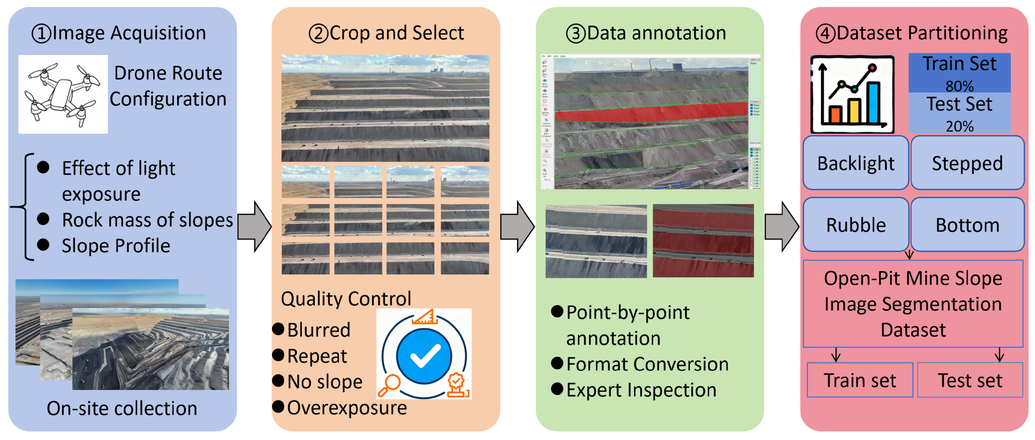
Figure 1. Preparation workflow of the OPMS-Seg dataset.
Remotesensing 18 03094 g001
Figure 2. Map Showing the Spatial Distribution of Five Open-Pit Coal Mines.
Remotesensing 18 03094 g002
Figure 3. Schematic diagram of UAV data-acquisition route. The red arrows indicate the UAV flight trajectory, and the arrowheads indicate the flight direction.
Remotesensing 18 03094 g003
Figure 4. Schematic diagram of image segmentation.
Remotesensing 18 03094 g004
Figure 5. Slope annotation process and label file.
Remotesensing 18 03094 g005
Figure 6. File structure of the OPMS-Seg dataset.
Remotesensing 18 03094 g006
Figure 7. Comparison of mIoU of four image segmentation algorithms.
Remotesensing 18 03094 g007
Figure 8. Visual comparison of binary slope segmentation results.
Remotesensing 18 03094 g008
Table 1. Overview of the Open-pit Mine Image Datasets.
Dataset NameTotal Number of ImagesTotal Number of AnnotationsNumber of CategoriesDevelopment Scenario
TPSet495349532Tailings storage facility identification
DOWHM187518751Mine area semantic segmentation
MUSeg31713171 × 215Multimodal semantic segmentation
MineSeg1341346Mine area segmentation
Table 2. Basic Information of the Five Open-pit Coal Mines.
MineSpatial LocationCoal TypeProduction Capacity (104/a)Coal Seam StrikeGeological ConditionsLatest Status
South Open-pit Mine89.2331°E,
44.8189°N
High-quality thermal coal4000Nearly east–west trending, with a gentle coal seam dipThe geological structure is simple, mining conditions are favorable, and the stripping ratio is low.In production
Open-pit Mine No. 189.1742°E,
44.9486°N
High-heat-value thermal coal3000Nearly east–west trendingGeological conditions are simple.National-level green mine
Open-pit Mine No. 289.1242°E,
44.8875°N
Non-adherent coal2000Overall trends northwest–southeast orientedThe project site is located within an ecological function zone.Phase I of the project has passed the environmental impact assessment
Open-pit Mine No. 489.0415°E,
44.8445°N
High-quality non-caking coal2300Northwest–southeast trending, coal seam stableModerate geological complexity, with an average total thickness of 46.79 m.In production
General Gobi No. 2 Open-Pit Mine89.0415°E,
44.8445°N
No. 31 Non-stick Coal2500Nearly east–west trending with a gentle dipThe geological structure is simple, and the coal seam exhibits stable storage characteristics.During production
Table 3. UAV Parameter Configuration.
Configuration CategoryParameter Values
ManufacturerShanghai Huace Navigation Technology Ltd., Shanghai, China
ModelBumblebee Quadrotor UAV BB-4 Model-PB4000658D
Maximum takeoff weight24.8 kg
Maximum endurance55 min
Flight speed6 m/s
Positioning accuracyCentimeter-level positioning accuracy
Operating environment temperature−20~50 °C
Oblique photogrammetry cameraAcquisition frequency: 30 FPS
Image resolution: 1920 × 1080
Table 4. Statistics of Image Screening.
Screening ReasonCulling Quantity
Sloped areas account for <50% of the total158
Motion blur/overexposure97
Repetition of content43
Obstacle occlusion24
Eliminate all of them322
Total number of original collections3136
Final retention2814
Table 5. OPMS-Seg Dataset Profile.
AttributeDescription
Dataset NameOPMS-Seg
Subject AreaRemote Sensing, Computer Vision, Mining Safety
Data TypeRGB Images + Semantic Segmentation Annotations
Image Format.jpg
Annotation FormatsJSON (COCO), TXT (YOLO), PNG (Binary Mask)
Data Volume1.64 GB
Total Images2814
Total Polygon Instances15,334 (average 5.45 per image)
Spatial CoverageZhundong Coalfield, Xinjiang, China (88–91°E, 44–45°N)
Temporal CoverageMay 2025–October 2025
LicenseCreative Commons Attribution 4.0 International (CC BY 4.0)
Table 6. Definition and Visual Characteristics of Slope Types.
TypeTag NameDefinitionVisual Characteristics
Backlight TypeBacklight_
Slope
A smooth, uniform slope with a near-constant inclination angle and no abrupt gradient changes. The “backlight” refers to UAV viewing conditions where the slope is illuminated from behind, enhancing boundary contrast.Straight or gently curved boundary; homogeneous surface; slope-background boundary clearly distinguishable under backlight.
Stepped TypeStepped_
Slope
A slope composed of two or more straight segments with distinctly different gradients, connected by abrupt angular changes (knickpoints), typically formed by multi-bench mining.Obvious breakpoints (knickpoints) on the slope face; polyline-shaped profile resembling stairs; flat benches clearly visible between steep segments.
Rubble TypeRubble_
Slope
A slope formed by loose, poorly sorted, angular rock fragments from frequent rockfall and debris accumulation, commonly found at active mining faces.Chaotic, rough, highly textured surface; scattered boulders, gravel, and debris piles; irregular and often indistinct boundary.
Bottom TypeBottom_
Slope
An irregular accumulation body at the toe of a bench or pit floor, formed by gravitational deposition of loose materials (rubble, soil, or coal fragments) that have slid from upper slopes. It has no distinct planar or stepped structures.Irregular, convex, or mound-shaped profile; loose, unconsolidated surface with no stratification or bench pattern; extends outward from slope toe with a gentle, variable angle.
Note: The four slope types defined in this table correspond to the four-class segmentation labels. For binary segmentation, all four types are merged into a single “slope” class.
Table 7. Distribution of Images Across Mining Areas.
Name of the Mining AreaTraining SetVerification SetTest SetIn Total
South Open-pit Mine7209090900
Open-pit Mine No. 15607070700
Open-pit Mine No. 24005050500
Open-pit Mine No. 43204040400
General Gobi No. 2 Open-Pit Mine2513231314
Total22512822812814
Table 8. Distribution of Images and Polygon Instances by Slope Type.
Slope TypeNumber of ImagesNumber of
Json
Number of
Txt
Number of
Polygon Instances
Average Instances per Image
Backlight Type31031031027158.7
Stepped Type65565565543906.7
Rubble Type14591459145967404.6
Bottom Type39039039014893.8
Total28142814281415,3345.4
Table 9. Software Dependencies for Validation Models.
DeeplabV3+YOLOv5-SegYOLOv11-Seg
PackagesVersionPackagesVersionPackagesVersion
Python3.6.13Python3.7.13Python3.8.8
Torch1.10.2Torch1.8.1Torch2.2.2
Torchaudio0.8.0Torchaudio0.8.1Torchaudio2.2.2
-0.11.3Torchvision0.9.1Torchvision0.17.2
tensorflow2.5.2Scipy1.7.3Scipy1.10.1
-2.4.0Pillow9.2.0Pillow10.3.0
Scipy1.4.1Tqdm4.64.1Tqdm4.66.2
Pillow8.2.0Pycocotools2.0.4Wheel0.41.2
Wheel0.37.1Timm0.9.12Timm1.0.7
Table 10. Comprehensive Evaluation Metrics for Baseline Models.
ModelmIo (%)mPA (%)Precision (%)Recall (%)F1Boundary IoU
YOLOv5-seg84.6289.0290.8289.4590.1787.65
YOLOv11-seg86.2490.5492.1791.7890.1487.69
Deeplabv3+89.4693.8391.8292.3792.0988.67
Unet88.5892.6592.1090.5090.8288.32
Disclaimer/Publisher’s Note: The statements, opinions and data contained in all publications are solely those of the individual author(s) and contributor(s) and not of MDPI and/or the editor(s). MDPI and/or the editor(s) disclaim responsibility for any injury to people or property resulting from any ideas, methods, instructions or products referred to in the content.