Article

Combining Satellite Remote Sensing Data with the FAO-56 Dual Approach for Water Use Mapping In Irrigated Wheat Fields of a Semi-Arid Region

by
Salah Er-Raki
1,*,
Abdelghani Chehbouni
2 and
Benoit Duchemin
2
1
FSSM-Faculty of Sciences Semlalia, Cadi Ayyad University/IRD, Avenue Prince Moulay Abdellah, BP 2390 Marrakech 40000, Morocco
2
Centre d’Etudes Spatiales de la Biosphère, Université de Toulouse, CNRS, IRD, CNES, 18 Avenue. Edouard Belin, bpi 2801, 31401 Toulouse cedex 9, France
*
Author to whom correspondence should be addressed.
Remote Sens. 2010, 2(1), 375-387; https://doi.org/10.3390/rs2010375
Submission received: 7 December 2009 / Revised: 7 January 2010 / Accepted: 18 January 2010 / Published: 20 January 2010

Abstract

:
The aim of this study was to combine the FAO-56 dual approach and remotely-sensed data for mapping water use (ETc) in irrigated wheat crops of a semi-arid region. The method is based on the relationships established between Normalized Difference Vegetation Index (NDVI) and crop biophysical variables such as basal crop coefficient, cover fraction and soil evaporation. A time series of high spatial resolution SPOT and Landsat images acquired during the 2002/2003 agricultural season has been used to generate the profiles of NDVI in each pixel that have been related to crop biophysical parameters which were used in conjunction with FAO-56 dual source approach. The obtained results showed that the spatial distribution of seasonal ETc varied between 200 and 450 mm depending to sowing date and the development of the vegetation. The validation of spatial results showed that the ETc estimated by FAO-56 corresponded well with actual ET measured by eddy covariance system over test sites of wheat, especially when soil evaporation and plant water stress are not encountered.

1. Introduction

Estimates of land surface evapotranspiration (ET) using remote sensing data are essential in effective planning of irrigation water use in arid and semiarid regions. The Haouz plain that surrounds the city of Marrakech (Central Morocco) is classified among the regions in the country facing strong water shortages. This is mainly due the combined effect of persistent drought and the increase of water demands related to increases in irrigated surfaces, urbanization and tourism recreational projects. There is thus a crucial need to develop tools for better management of irrigation water use through accurate estimates of crop water requirement (ETc) at a regional scale.
Over the last decades, several methods for estimating ET based on combination of crop modelling and remotely-sensed data have been developed. These methods ranged from simple ones such as the Vegetation Index/Temperature trapezoid [1], to complex land surface models [2]. However, due to low frequency of the required high resolution satellite data combined the intermittent presence of cloud makes these approaches of little interest for operational purposes [3].
The most common and practical approach used for estimating crop water requirement is the FAO-56 method [4]. For the operational monitoring of soil-plant water balance, the FAO-56 model is often preferred to complex soil-vegetation-atmosphere-transfer models. In the FAO-56 approach, ETc is estimated through the combination of a reference evapotranspiration (ET0) and crop coefficients. There are two different FAO-56 approaches: single and dual crop coefficients. In the single crop coefficient approach, the plant transpiration and soil evaporation are combined into a single crop coefficient (Kc). The dual crop coefficient approach uses two coefficients to separate the respective contribution of plant transpiration (Kcb) and soil evaporation (Ke).
Remotely sensed spectral reflectance may provide an indirect estimate of crop coefficient or basal crop coefficients. Indeed, several authors have shown similarity between the seasonal patterns of vegetation indices and transpiration over annual crops [5,6,7,8,9,10,11,12]. Consequently, Kc can be estimated from spectral vegetation indices since both of them are related to leaf area index and fractional ground cover [13,14,15]. In this context, several relationships between Kc and vegetation indices have been established. However, there is no agreement on the nature and generality of these relationships [16]. Some studies [6,7,8,11,14,17] have shown that these relationships are linear, but others have found non linearity relationships [9,10,12,16]. Therefore, establishing a unique relationship between crop coefficient and spectral vegetation indices is an ongoing research topic.
In this study, we focused on the FAO-56 dual crop coefficient model to derive ETc maps from remote sensing data through the use of relationships between the Normalized Difference Vegetation Index (NDVI) and crop biophysical variables such as basal crop coefficient, cover fraction. The objective is to incorporate these relationships into the FAO-56 dual crop coefficient model to derive seasonal variation of evapotranspiration maps. This approach has been previously evaluated at a local scale using local field measurements [12]. Here, our aim is to extend the approach to larger scale using NDVI data derived from SPOT and Landsat images during the 2002/2003 agricultural season. The approach is implemented over an irrigated district located in the Haouz plain, 40 km East of Marrakech (Central Morocco), as part of the SudMed project [18].

2. Materials and Methods

2.1. Study Area
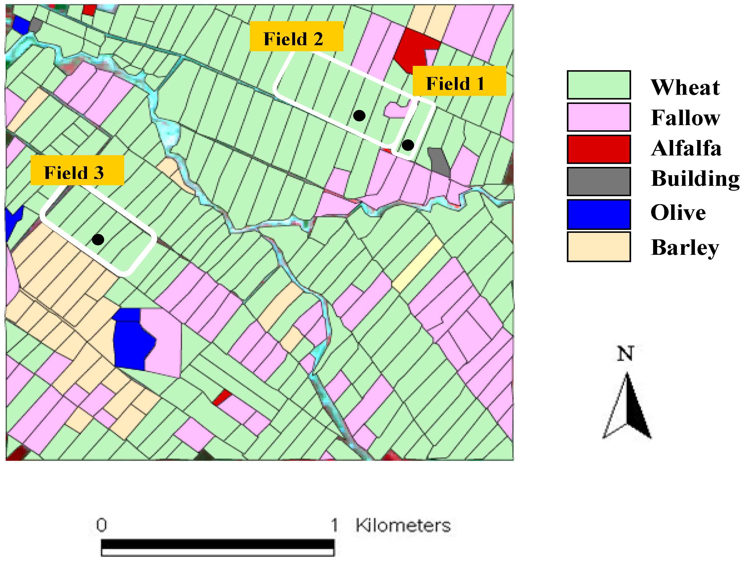
The region of interest is an irrigated area located in the Haouz plain in the centre of the Tensift basin (Central Morocco), 40 km east of Marrakech city. The climate is of semi arid Mediterranean type with an average annual precipitation of about 250 mm of which 70 % falls during winter and spring. The soil type is clay to loam. The area covers about 2,800 ha and is mostly flat. The main land cover classes are cereals; mostly wheat, then barley (Figure 1). The distribution of dam irrigation water is organized by a regional public agency (ORMVAH) together with the local farmer associations. For wheat crops during the 2002–2003 seasons, three irrigation rounds were decided on, with an amount of around 30 mm in equivalent water depth each time. Field 1 was irrigated six times using ground water. More details about the site description and experimental data are given in [11,12].
Figure 1. Land cover (coloured shapes) and location of three wheat fields (delimited with white rectangles) under study during 2002–2003 agricultural season in the Tensift AL Haouz, Marrakech, Morocco. The towers equipped with evapotranspiration measurement systems (black disks) are located in each field.
Remotesensing 02 00375 g001

2.2. Data Description

Meteorological measurements were recorded within the irrigated area using an automated weather station consisting of measurements of solar radiation, air temperature and humidity, wind speed, net radiation and rainfall. Daily averaged values of climatic data were calculated in order to compute the daily reference evapotranspiration ET0 (mm/day), according to the FAO-56 Penman-Monteith parameterization [4]. Three eddy-covariance systems were also installed over three fields of wheat to provide continuous measurements of evapotranspiration flux (Figure 1). These data were used to validate spatial ET estimates zooming on each of these fields. Detail on the climatic and flux measurements can be found in [12].
In addition of climatic and flux measurements, a time series of 20 high spatial resolution images acquired by Landsat and SPOT was collected during the growing season of wheat. Due to cloudiness or uncertainty in atmospheric corrections, only 10 images have been used in this study. These images were radiometrically calibrated and atmospherically corrected based on the reflectance of an invariant objects and transformed to NDVI maps [19]. The NDVI was derived from red and near infrared reflectances bands after resampling of the time series of images at 20 m. The geometric correction of satellite images was performed using the Ground Control Points collected during the experiment. The radiometric correction was achieved in three steps. Firstly, we corrected a “reference” image from atmospheric effects using the SMAC correction algorithm [20] and standard values of atmospheric components. Secondly, the radiometry of each image were homogenised against this reference images thanks to a set of reliable invariant features [21]. This normalisation was performed by applying linear relationships which were established on these invariants between the digital numbers of raw images and the reflectance values of the reference image. Thirdly, an additional linear correction has been applied between the satellite NDVI values and the NDVI ground measurements collected using the hand-held Cropscan MultiSpectral Radiometer [12]. This inter-calibration ensures a maximal agreement between satellite and surface NDVI values.

2.3. Model Description

The model used in this study is the FAO-56 dual crop coefficient developed by [4]. This model describes the relationship between the crop evapotranspiration under standard non-stressed conditions (ETc) and reference evapotranspiration (ET0) by separating crop coefficient (Kc) into the basal crop coefficient (Kcb) and soil water evaporation (Ke) coefficients:
ETc = (Kcb + Ke) * ET0
where ET0 is calculated at daily time step by the FAO Penman-Monteith equation (Equation 6 in FAO-56 paper). In order to integrate the remote sensing data into FAO model, the others parameters (Kcb and Ke) for the equation 1 were derived from NDVI by equations 2 and 3, respectively. More details about these equations are available in [12]. The local calibration performed in [12] was also retained here, the only difference being the source of the NDVI data (satellite or hand-held radiometer). Thus there is no contradiction to state that local calibration is necessary and to find that the same method driven by satellite data is accurate:
K c b = 1.07 * [ 1 ( N D V I max N D V I N D V I max N D V I min ) 0.84 0.54 ]
K e = 0.25 * ( 1 f c )
where NDVImin and NDVImax are the minimum and the maximum values of NDVI associated with bare soil and dense vegetation, respectively. The values 0.14 and 0.93 are used in this study. fc is the vegetation fraction cover given by [12]:
f c = 1.18 * ( N D V I N D V I min )
Equation 2 presents the general form of the equation for deriving Kcb from vegetation indices as shown by [15,16]. An empirical function between Kcb and NDVI, consisting of two regressions, has been found by [9] for cotton crops. Other authors [6,14,17,22] have found linear Kcb-VI relationships.
For Equation 3, it is a simple formalism to account for the fact that soil evaporation occurs predominantly from the exposed soil. Soil evaporation coefficient (Ke) is clearly correlated with (1-fc). This equation showed that Ke decreases with the development of crop (increase of fraction of ground cover, fc) and becomes negligible when the crop is well developed and completely covers the soil (fc = 1). The relation between Ke and (1-fc) is also modulated with the value 0.25. The value 0.25 was determined according to the figure 29 in the FAO-56 book [4] based on the observed frequency of water supply (≈10 days) and the average value of ET0 (4 mm/day) during the growing season.

3. Results and Discussion

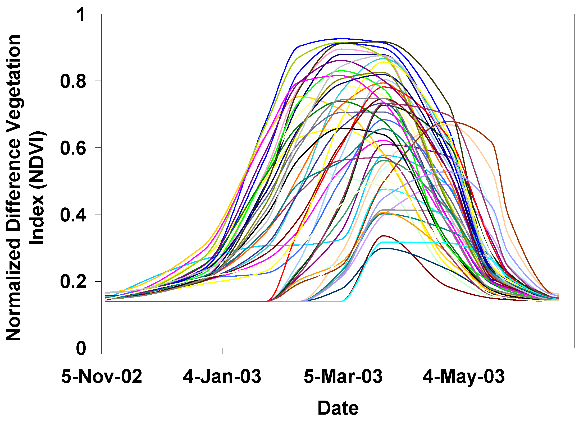
Before applying the FAO dual approach in each pixel, we masked the images to keep only wheat fields. A binary mask (wheat) was built from the land cover map [11], and was superimposed on surface NDVI images to keep only wheat pixels. After masking the wheat planting, we used an unsupervised classification method (K-means, [23]) to regroup the pixels which have similar NDVI profiles. 50 different classes were extracted (Figure 2). The principle of K-means is summarized in the Appendix.
Figure 2. Profiles of NDVI corresponding to 50 classes of winter wheat identified by K-means classification. A cubic interpolation method was used to determine the values of NDVI between two satellite overpass.
Remotesensing 02 00375 g002
The inter-class variability is due to the differences in agricultural practices (sowing date, irrigation, fertilization…). Plant sowing dates were computed based on the time profiles of NDVI (Figure 3). The sowing date is determined based on the vegetation fraction cover (fc) derived from NDVI through Equation 4. Sowing dates are determined from emergence dates (identified using a fc = 0.1 criteria) by subtracting 13 days for early sown crops and 20 days for late sown crops. The values (13 days and 20 days) were determined based on the observations in some cultivated fields. The time lag between sowing and emergence is larger for late sown crops because lower temperatures were experienced at this time of year. It can be seen in Figure 3 that there is a large spatial variability in sowing dates, with two distinct periods: early (before December 15) and late (after January 15). This was found consistent with field observations of sowing dates.
Figure 3. Map of sowing date of winter wheat. The value 1 corresponds to November 7th 2002. Note that the sowing date was calculated by subtracting 13 days for early sown crops and 20 days for late sown crops from the date corresponding to f c = 0.1.
Remotesensing 02 00375 g003
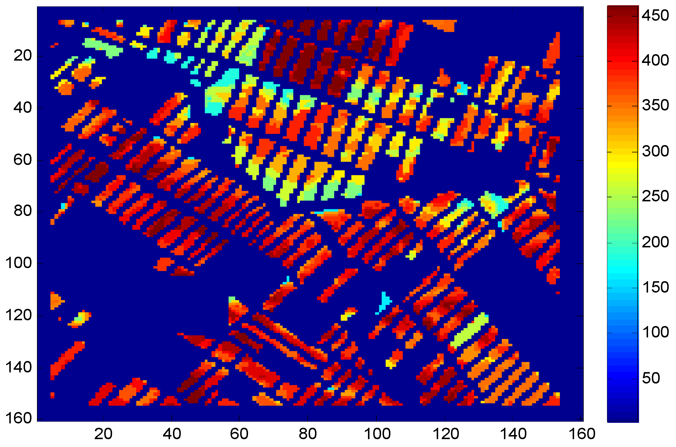
After, we derived the map of the seasonal ETc (mm) of winter wheat by cumulating daily values of ETc between sowing and full senescence stages (Figure 4). Daily crop water requirement (ETc) was calculated by multiplying daily Kc of daily ET0 (Equation 1). As mentioned above, Kc was derived through the relationships between Kcb and NDVI (Equation 2), and between Ke and NDVI (Equation 3). In addition, a cubic interpolation was used to determine the values of NDVI between two satellite overpass. Figure 4 shows that the values of seasonal ETc varied between 200 and 450 mm, with an average value of 330 mm. The observed variability of ETc can be mainly explained by two major factors. The first one is the length of crop cycle, due to differences in sowing dates. This is well captured using spectral vegetation index. The cycle is very short for the late sowing classes and larger for early sowing ones. As it can be seen in Figure 2, the amplitude of NDVI (or Kc) is lower for the late sowing classes (<0.5) and higher for early sowing classes (>0.8). This result is in agreement with other studies [24,25]. The second factor is cropping practices i.e., irrigation, application or not of nutrients, wheat variety. Globally, the obtained values of ETc are also in accordance with others studies [26,27], which found that the ETc of wheat cultivated in Morocco is around 480 mm depending to the wheat variety and sowing date. The obtained results reveal the potential of remote sensing data to estimate crop water requirements (ETc) on an operational basis and consumption at a regional scale.
Figure 4. Map of seasonal crop water requirement ETc (in mm) of winter wheat obtained by applying the FAO-56 dual approach.
Remotesensing 02 00375 g004
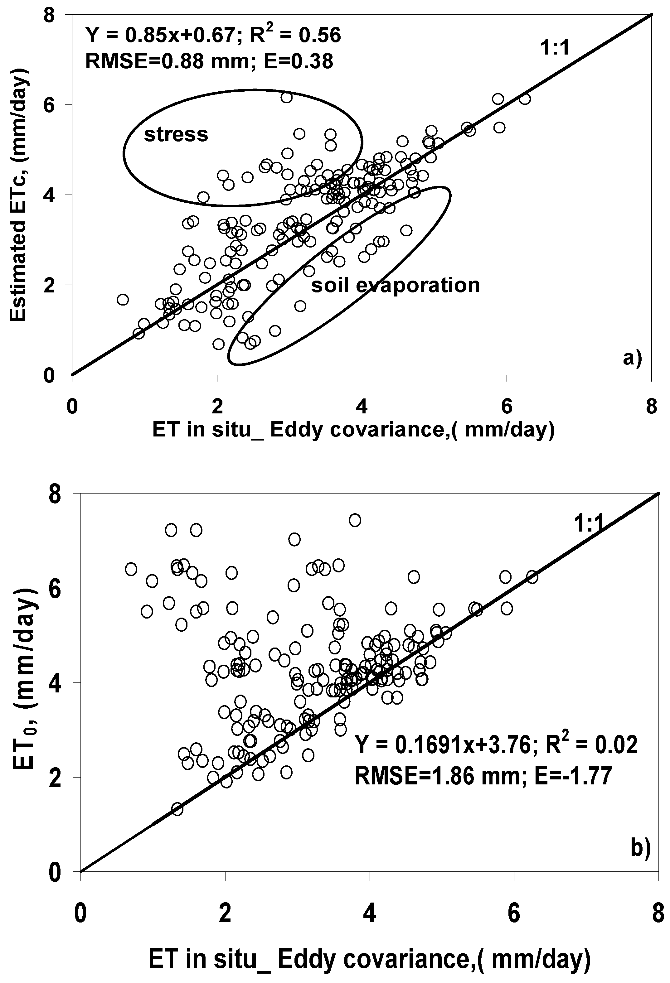
To assess the performance of the FAO-56 model, we compared ETc calculated by this approach with the measured ET over three fields of wheat (Figure 5a). According to this figure, it is safe to state that the FAO-56 correctly simulates ETc using remote sensing data. The corresponding Root Mean Square Error (RMSE) was about 0.88 mm per day can be considered acceptable regarding to the average values of ETc (about 3.6 mm per day). The coefficient of determination (R2) is around 0.5, the efficiency (E) is around 0.4 and the slope is close to 1.
However Figure 5a shows that some discrepancies between observed and simulated ET occurred under specific conditions. To identify the reasons of these discrepancies, we analysed soil moisture data collected in these fields [12]. According to soil moisture data, the model seems to over-estimate ET when the plant is stressed and under-estimate ET when the soil fully evaporates. This is because the FAO model simulates the evapotranspiration under no limiting water supply and with an average value for soil evaporation (0.25) while the measurements are for actual conditions (presence of the stress). The approximation of Ke is not satisfactory for spatial monitoring. It may vary greatly regarding the large heterogeneity in the water supply in terms of amount and periods of distribution.
In order to quantify the gain due to the driving of Kc by NDVI, the comparison between (ET0, i.e., Kc = 1) and actual ET measured at three fields of wheat using eddy covariance system has been made (Figure 5b). According to this comparison, measured ET appeared evidently overestimated and there is no clear relationship between the two variables. The coefficient of determination R2 is equal to 0.02, showing that the two variables are not linearly related. The corresponding RMSE (1.9 mm) and the efficiency (E = −1.77) are also not acceptable.
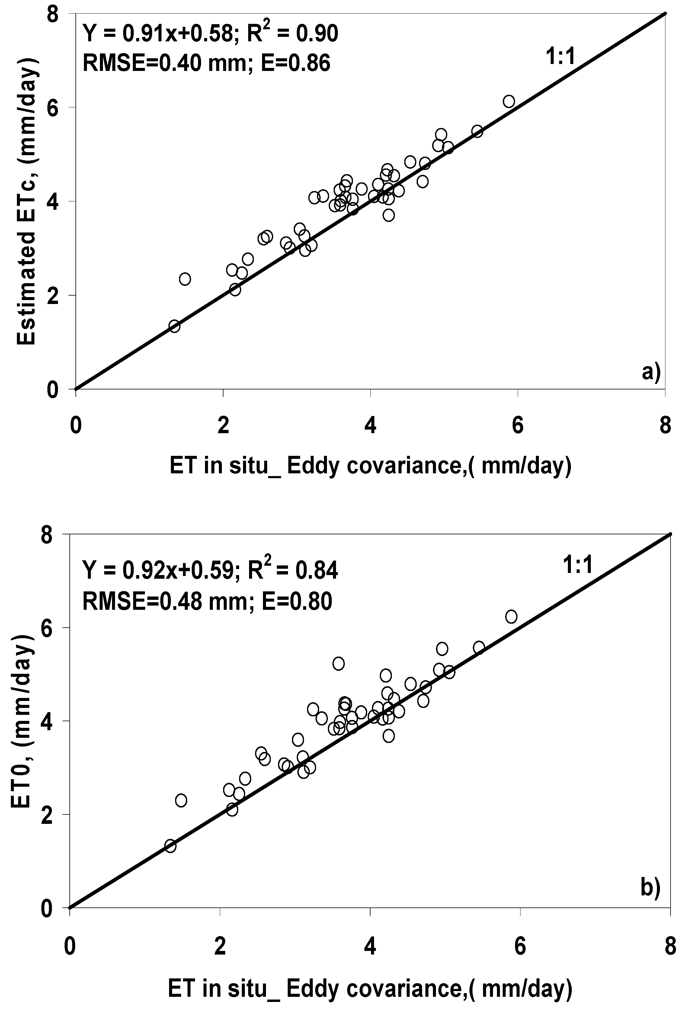
In order to test the accuracy of our approach, we compared the ETc provided by this model under standard conditions with the measurements for wheat field 1. This field was monitored during the period of maturity (high vegetation recovering, thus reduced soil evaporation) and was irrigated six times to prevent plant water stress. In this case, there is a close agreement between simulated and measured ETc (Figure 6a); the coefficient of determination and the efficiency are larger than 0.85 and the RMSE is around 0.40 mm per day.
Figure 5. Scatter plot between daily estimated evapotranspiration (ETc) by the FAO-56 dual approach (Figure 5a), reference ET0 (Figure 5b), and measured actual (ET) by Eddy covariance technique over three fields of wheat in the Tensift basin (center of Morocco). The graph includes the 1:1 line.
Remotesensing 02 00375 g005
Knowing that the Kc values of the mature wheat under standard non-stressed conditions are close to 1 [4], it is of interest to check this and to quantify also the contribution of Kc in calculating crop evapotarnspiration (ETc). For this purpose, we plotted (ET0, i.e., Kc = 1) against actual ET measured over field 1 under standard conditions (Figure 6b). This comparison revealed practically perfect agreement almost similarly to figure 6a (R2 = 0.84, with E = 0.80 and RMSE = 0.48 mm) between the two variables, justifying that the contribution of Kc was minimal since the crop is mature and moisture is unlimited. This is in agreement with other studies (e.g., [10,12]) when they found that the Kc derived from NDVI was quasi-equal to 1 for the mature wheat developed under standards conditions. The difference is the source of NDVI data; the ground remotely-sensed measurements have been used for deriving Kc instead of satellite remote sensing data used in this study.
Figure 6. Same as Figure 5, but for one field (field 1) of mature wheat under standard conditions (no stress) and the soil evaporation was negligible.
Remotesensing 02 00375 g006
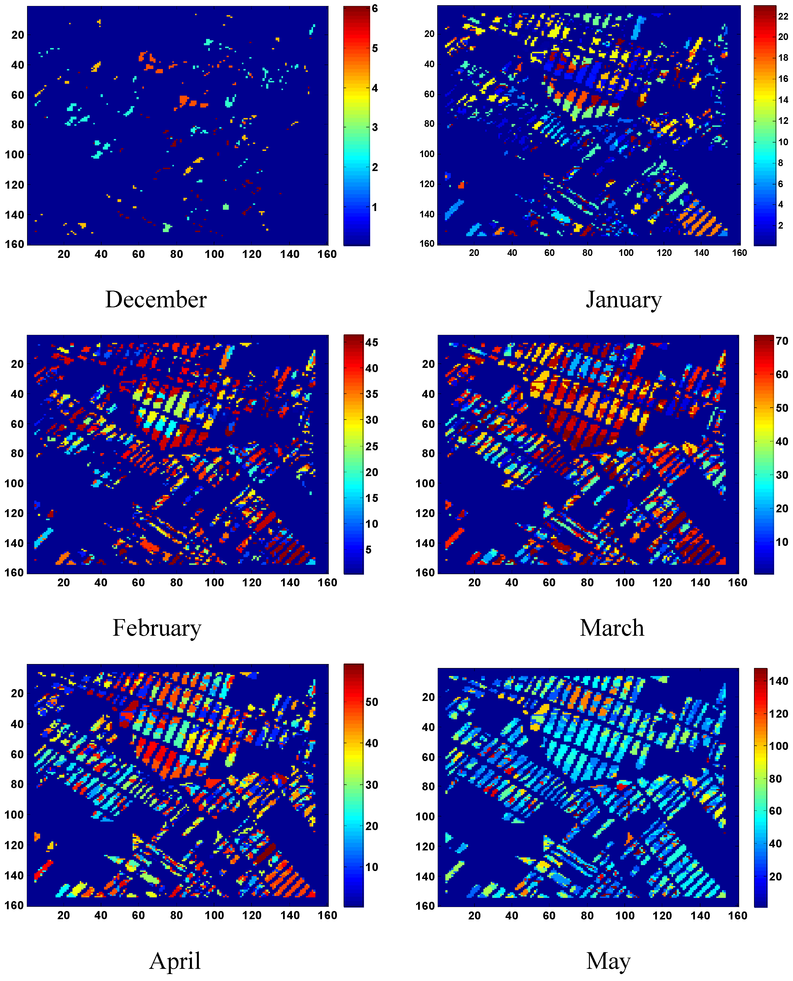
Based on the calculation of ETc, the amount of irrigation needed for the wheat was derived as the difference between ETc and precipitation. The spatial and temporal distributed of irrigation needs was presented in Figure 7. Temporally, the irrigation amount appears the largest in March and April when it is the peak period of winter wheat development and the reference evapotranspiration begins to be large. It is the smallest in December and May, when winter wheat was in the initial and senescence stages. The obtained cumulative amount of irrigation needs during the whole growing season varied between 50 and 220 mm, depending of sowing date. This value is centered on (about 135 mm) the amount which has been supplied during this agricultural season by the regional office which is in charge of the distribution of dam water for irrigation. Maps of irrigations could be used by farmers to assist in water management and irrigation scheduling potentially saving water and improving yield.
Figure 7. Spatial and temporal distribution of irrigation amount (mm) of winter wheat in the Tensift ALHaouz basin during 2002–2003 growing season.
Remotesensing 02 00375 g007

4. Conclusions and Perspectives

This study showed that how remote sensing data can be integrated in FAO dual approach for mapping water use (ETc) of wheat crop in semi arid region. The method consists of linking the main crop biophysical parameters (basal crop coefficient, cover fraction) to the Normalized Difference Vegetation Index (NDVI). The results showed that remote sensing estimates of ETc compare very satisfactorily with ground measurements, especially when the soil evaporation and plant water stress are negligible. The RMSE between measured and estimated ET was about 0.40 mm per day.
For actual estimates of ET, developments should be done to get information about plant water stress. Additional information such as surface temperature (which is the most indicator of the stress) from TIR sensors can be very useful. In the near future we apply spatially an innovative approach tested at local scale by [28]. It consists of assimilating daily ET from TIR data combined to an energy balance model into FAO approach. Finally, it should be noted that our approach was tested only for the wheat crop. The method should be tested over an extended spatially distributed dataset with different crops.

5. Acknowledgements

This study was conducted within the Framework of the Sudmed project with a strong support of IRD (Institut de Recherche pour le Développement) and UCAM (Université Cadi Ayyad de Marrakech). Additional funding was provided by AUF (‘the Action de Recherche du Réseau Télédétection de l’Agence Universitaire de la Francophonie’) through 2092 RR 915 contract. The authors are grateful to ORMVAH (‘Office Regional de Mise en Valeur Agricole du Haouz’, Marrakech, Morocco) for its technical help in collecting field data. French CNRS-PNTS and CNES-ISIS programs are acknowledged for their support. The authors also thank three anonymous reviewers and the editor for their insightful comments.

References

  1. Moran, M.S.; Clarke, T.R.; Inoue, Y.; Vidal, A. Estimating crop water deficit using the relation between surface-air temperature and spectral vegetation index. Remote Sens. Environ. 1994, 49, 246–263. [Google Scholar] [CrossRef]
  2. Bastiaanssen, W.G.M. SEBAL-based sensible and latent heat fluxes in the irrigated Gediz Basin, Turkey. J. Hydrol. 2000, 229, 87–100. [Google Scholar] [CrossRef]
  3. Takeuchi, W.; Tamura, M.; Yasuoka, Y. Estimation of methane emission from West Siberian wetland by scaling technique between NOAA AVHRR and SPOT HRV. Remote Sens. Environ. 2003, 85, 9–21. [Google Scholar] [CrossRef]
  4. Allen, R.G.; Pereira, L.S.; Raes, D.; Smith, M. Crop Evapotranspiration: Guidelines for Computing Crop Water Requirements; FAO Irrigation and Drainage Paper 56; FAO: Rome, Italy, 1998; p. 300. [Google Scholar]
  5. Jackson, R.D.; Idso, S.B.; Reginato, R.J.; Pinter, P.J., Jr. Remotely sensed crop temperatures and reflectances as inputs to irrigation scheduling. In Irrigation and Drainage: Today’s Challenges; ASCE: New York, NY, USA, 1980; pp. 390–397. [Google Scholar]
  6. Bausch, W.C.; Neale, C.M.U. Crop coefficients derived from reflected canopy radiation: a concept. Trans. ASAE 1987, 30, 703–709. [Google Scholar] [CrossRef]
  7. Bausch, W.C. Soil background effects on reflectance-based crop coefficients for corn. Remote Sens. Environ. 1993, 46, 213–222. [Google Scholar] [CrossRef]
  8. Bausch, W.C. Remote sensing of crop coefficients for improving the irrigation scheduling of corn. Agr. Water Manage. 1995, 27, 55–68. [Google Scholar] [CrossRef]
  9. Hunsaker, D.J.; Pinter, P.J., Jr.; Barnes, E.M.; Kimball, B.A. Estimating cotton evapotranspiration crop coefficients with a multispectral vegetation index. Irrig. Sci. 2003, 22, 95–104. [Google Scholar] [CrossRef]
  10. Hunsaker, D.J.; Pinter, P.J., Jr.; Kimball, B.A. Wheat basal crop coefficients determined by normalized difference vegetation index. Irrig. Sci. 2005, 24, 1–14. [Google Scholar] [CrossRef]
  11. Duchemin, B.; Hadria, R.; Er-Raki, S.; Boulet, G.; Maisongrande, P.; Chehbouni, A.; Escadafal, R.; Ezzahar, J.; Hoedjes, J.; Karrou, H.; Khabba, S.; Mougenot, B.; Olioso, A.; Rodriguez, J.-C.; Simonneaux, V. Monitoring wheat phenology and irrigation in Central Morocco: on the use of relationship between evapotranspiration, crops coefficients, leaf area index and remotely-sensed vegetation indices. Agr. Water Manage. 2006, 79, 1–27. [Google Scholar] [CrossRef]
  12. Er-Raki, S.; Chehbouni, A.; Guemouria, N.; Duchemin, B.; Ezzahar, J.; Hadria, R. Combining FAO-56 model and ground-based remote sensing to estimate water consumptions of wheat crops in a semi-arid region. Agr. Water Manage. 2007, 87, 41–54. [Google Scholar] [CrossRef]
  13. Heilman, J.L.; Heilman, W.E.; Moore, D.G. Evaluating the crop coefficient using spectrales reflectance. Agron. J. 1982, 74, 967–971. [Google Scholar] [CrossRef]
  14. Neale, C.M.U.; Bausch, W.C.; Heerman, D.F. Development of reflectance-based crop coefficients for corn. Trans. ASAE 1989, 32, 1891–1899. [Google Scholar] [CrossRef]
  15. Choudhury, B.J.; Ahmed, N.U.; Idso, S.B.; Reginato, R.J.; Daughtry, C.S.T. Relations between evaporation coefficients and vegetation indices studies by model simulations. Remote Sens. Environ. 1994, 50, 1–17. [Google Scholar] [CrossRef]
  16. Gonzalez-Dugo, M.P.; Mateos, L. Spectral vegetation indices for benchmarking water productivity of irrigated cotton and sugarbeet crops. Agr. Water Manage. 2008, 95, 48–58. [Google Scholar] [CrossRef]
  17. Gonzalez-Piqueras, J.; Calera Belmonte, A.; Gilabert, M.A.; Cuesta García, A.; De la Cruz Tercero, F. Estimation of crop coefficients by means of optimized vegetation indices for corn. In Proceedings of the SPIE Congress, Barcelona, Spain, September, 2003; pp. 110–118.
  18. Chehbouni, A.; Escadafal, R.; Boulet, G.; Duchemin, B.; Simonneaux, V.; Dedieu, G.; Mougenot, B.; Khabba, S.; Kharrou, H.; Merlin, O.; Chaponnière, A.; Ezzahar, J.; Er-Raki, S.; Hoedjes, J.; Hadria, R.; Abourida, H.; Cheggour, A.; Raibi, F.; Hanich, L.; Guemouria, N.; Chehbouni, Ah.; Lahrouni, A.; Olioso, A.; Jacob, F.; Sobrino, J. The use of remotely sensed data for integrated hydrological modeling in arid and semi-arid regions: the SUDMED program. Int. J. Remote Sens. 2008, 29, 5161–5181. [Google Scholar] [CrossRef] [Green Version]
  19. Simonneaux, V.; Duchemin, B.; Helson, D.; Er-Raki, S.; Olioso, A.; Chehbouni, A. The use of high-resolution image time series for crop classification and evapotranspiration estimate over an irrigated area in central Morocco. Int. J. Remote Sens. 2007, 29, 95–116. [Google Scholar] [CrossRef] [Green Version]
  20. Rahman, H.; Dedieu, G. SMAC: a simplified method for the atmospheric correction of satellite measurements in the solar spectrum. Int. J. Remote Sens. 1994, 15, 123–143. [Google Scholar] [CrossRef]
  21. Schott, J.R.; Salvaggio, C.; Volchock, W.J. Radiometric scene normalization using pseudo invariant features. Remote Sens. Environ. 1988, 26, 1–16. [Google Scholar] [CrossRef]
  22. D’Urso, G.; Calera Belmonte, A. Operative approaches to determine crop water requirements from earth observation data: methodologies and applications. In Earth Observation for Vegetation Monitoring and Water Management; D’Urso, G., Jochum, M.A.O., Moreno, J., Eds.; American Institute of Physics: Melville, NY, USA, 2006; pp. 14–25. [Google Scholar]
  23. MacQueen, J.B. Some methods for classification and analysis of multivariate observations. In Proceedings of Fifth Berkeley Symposium on Mathematical Statistics and Probability, Berkeley, CA, USA; 1967; pp. 281–297. [Google Scholar]
  24. Duchemin, B.; Er-Raki, S.; Gentine, P.; Maisongrande, P.; Coret, L.; Boulet, G.; Rodriguez, J.-C.; Simonneaux, V.; Chehbouni, A.; Dedieu, G.; Guemouria, N. Estimating Cereal Evapotranspiration using a Simple Model driven by Satellite Data. In Proceding of IEEE International Geoscience and Remote Sensing Symposium, Toulouse, France, 2003; pp. 21–25.
  25. Er-Raki, S.; Chehbouni, A.; Guemouria, N.; Duchemin, B.; Ezzahar, J.; Hadria, R.; BenHadj, I. Driven FAO-56 dual crop coefficient approach with remotely-sensed data for estimating water consumptions of wheat crops in a semi-arid region. In Second Recent Advances in Quantitative Remote Sensing; Sobrino, J.A., Ed.; Universitat de Valencia: Valencia, Spain, 2006; pp. 431–437. [Google Scholar]
  26. Bamouh, A. Effets d'une sécheresse en début de cycle sur l'élaboration du rendement du blé tendre "Nesma 149"; Mémoire de Troisième Cycle, Institut Agronomique et Vétérinaire Hassan II: Rabat, Morocco, 1981. [Google Scholar]
  27. Elqortobi, A. Simulation du déficit hydrique et prédiction des rendements des céréales d’automne; Mémoire de 3éme cycle Agronomie, Département d’agronomie, IAV Hassan II: Rabat, Morocco, 1987. [Google Scholar]
  28. Er-Raki, S.; Chehbouni, A.; Hoedjes, J.; Ezzahar, J.; Duchemin, B.; Jacob, F. Improvement of FAO-56 method for olive orchards through sequential assimilation of thermal infrared based estimates of ET. Agr. Water Manage. 2008, 95, 309–321. [Google Scholar] [CrossRef]

Appendix: K-means Method

An unsupervised classification method (K-means, [23]) has been used to regroup the pixels which have similar NDVI profiles. The principle of K-means is summarized in the following steps:
  • Step 1: choose randomly k centers of classes
  • Step 2: Assign to k centers each object to the group that has the closest centroid.
  • Step 3: Recalculate the positions of the centroids.
  • Step 4: If the positions of the centroids didn't change go to the next step, else go to Step 2.
  • Step 5: End.
In order to find good groups, the distance intra groups (intra) must be minimized, and the distance inter groups (inter) must be maximized.
i n t r a = 1 N i = 1 k x C j x z j 2
i n t e r = m i n ( z i z j 2 )
where N: Number of elements; Zi: Centre of group i.