
Habitat Mapping and Quality Assessment of NATURA 2000 Heathland Using Airborne Imaging Spectroscopy

 , , ,
, , , 
 ,
, 
Abstract
:
1. Introduction
2. Materials and Methods
2.1. Study Area
2.2. Datasets
2.2.1. Ground Reference Data
2.2.2. Imaging Spectroscopy Data
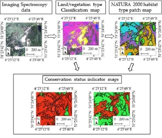
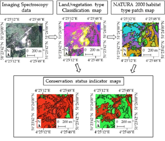
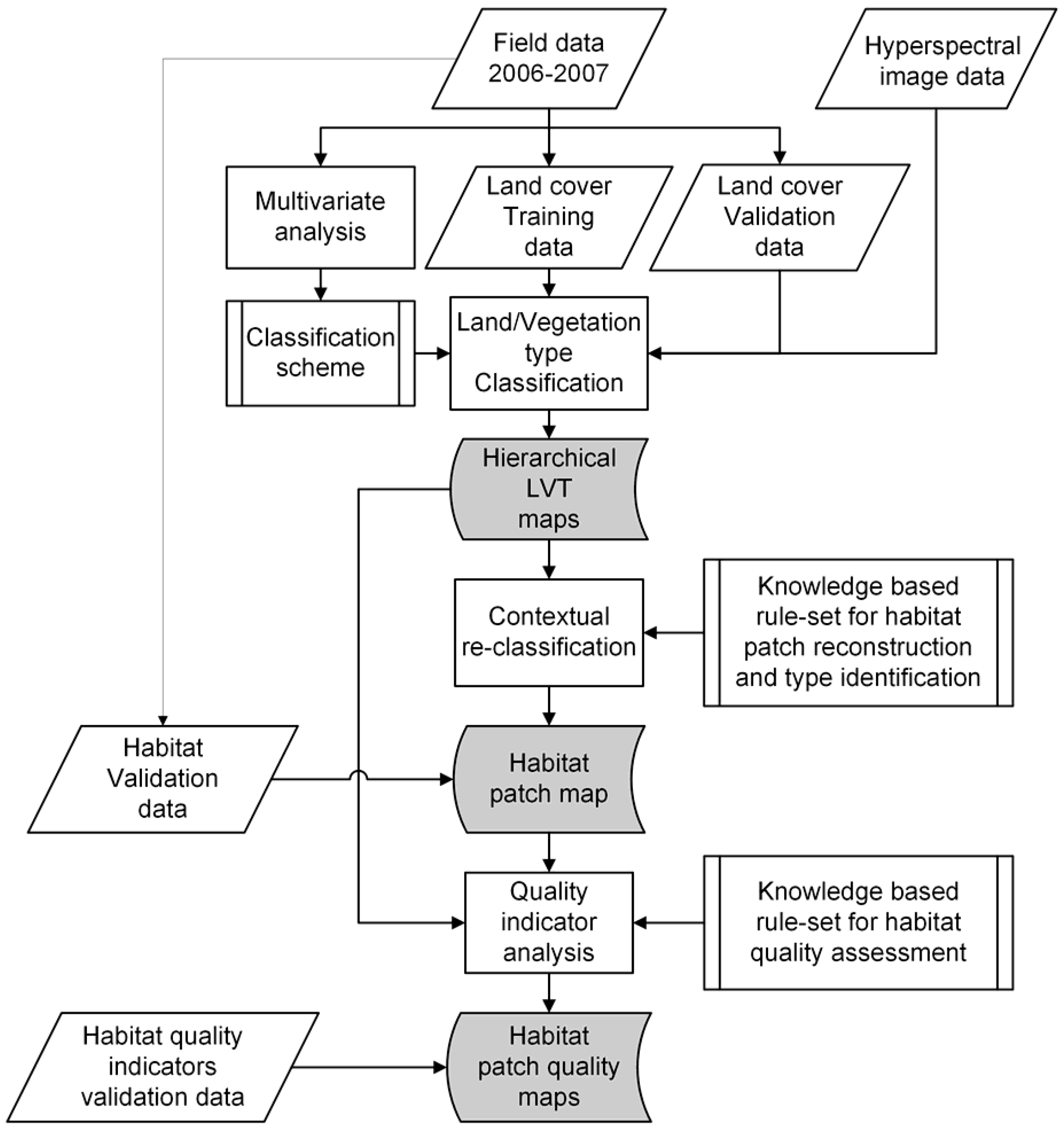
2.3. Method Overview
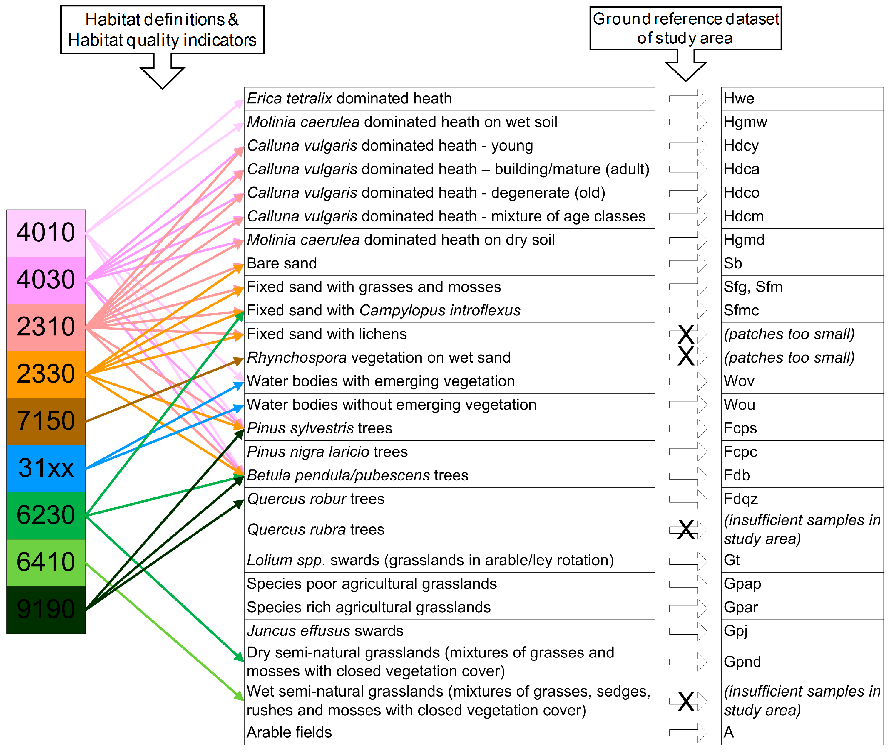
2.4. Design of a Dedicated Hierarchical LVT Classification Scheme
2.5. Land/Vegetation Type Classification
2.6. Habitat Patch Mapping
2.7. Habitat Type Identification
2.8. Assessment of Habitat Quality
2.9. Method Implementation
3. Results
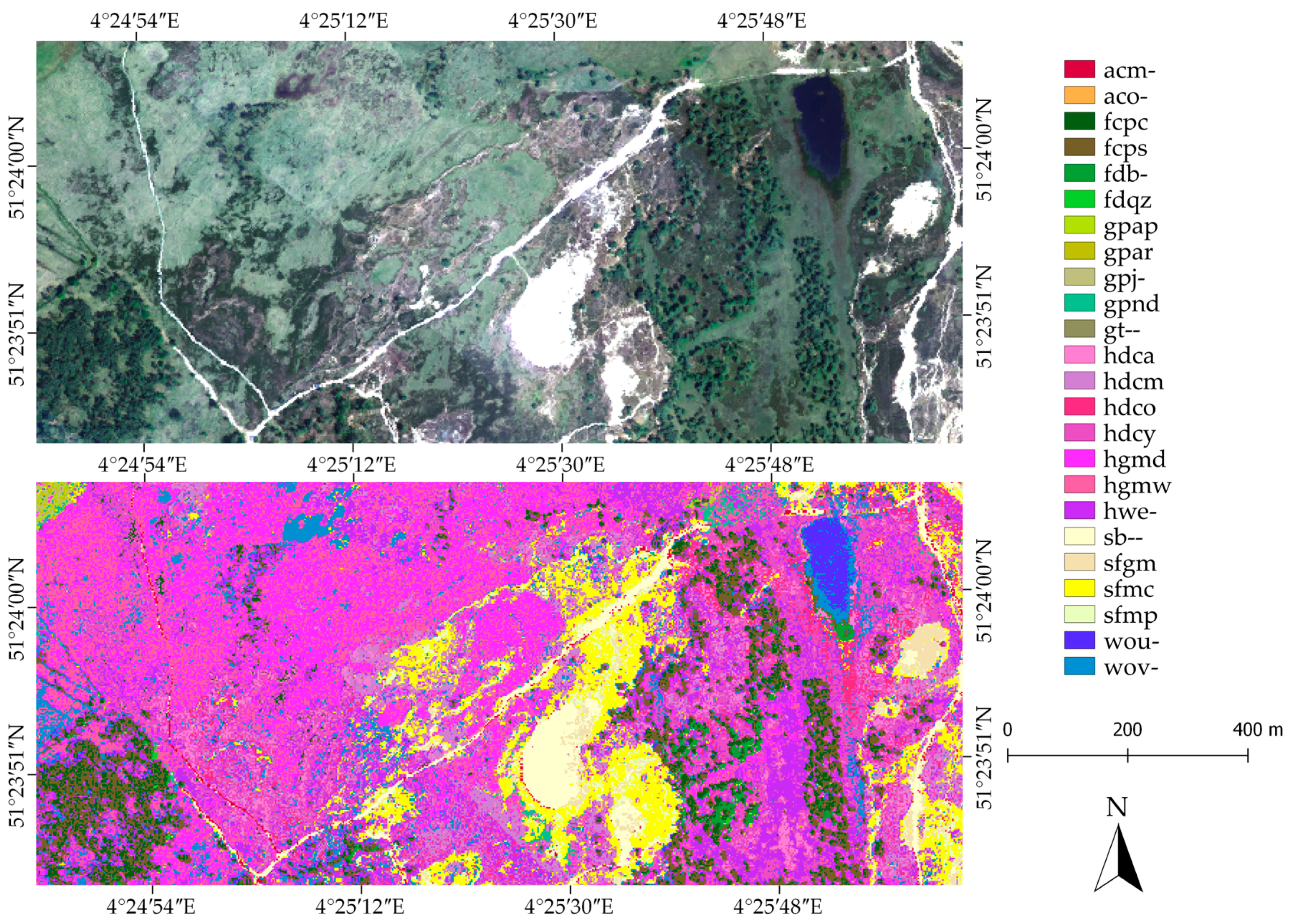
3.1. Land/Vegetation Type Classification Results
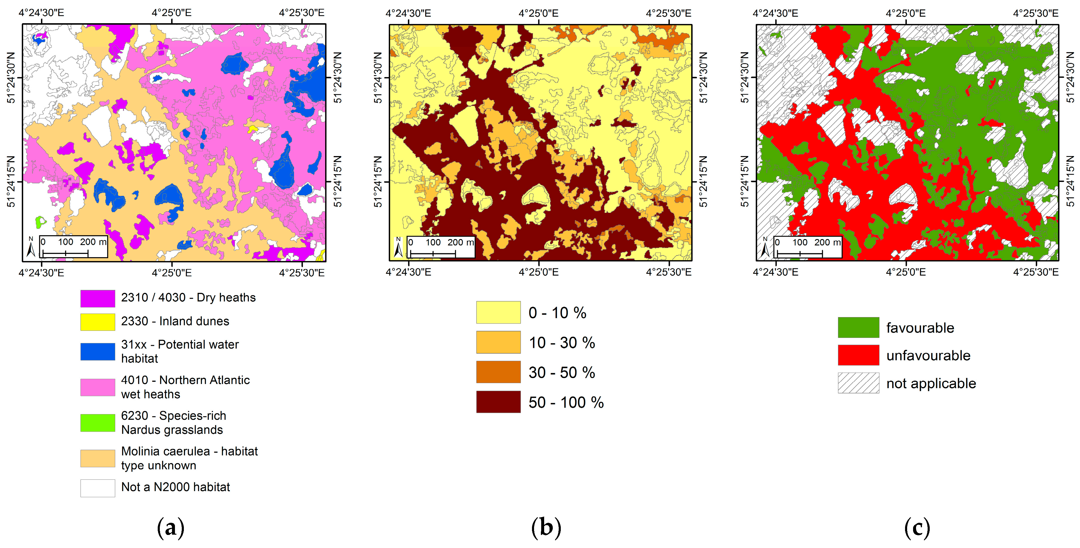
3.2. Habitat Type Patch Map Results
3.3. Assessment of Habitat Quality at the Patch Level
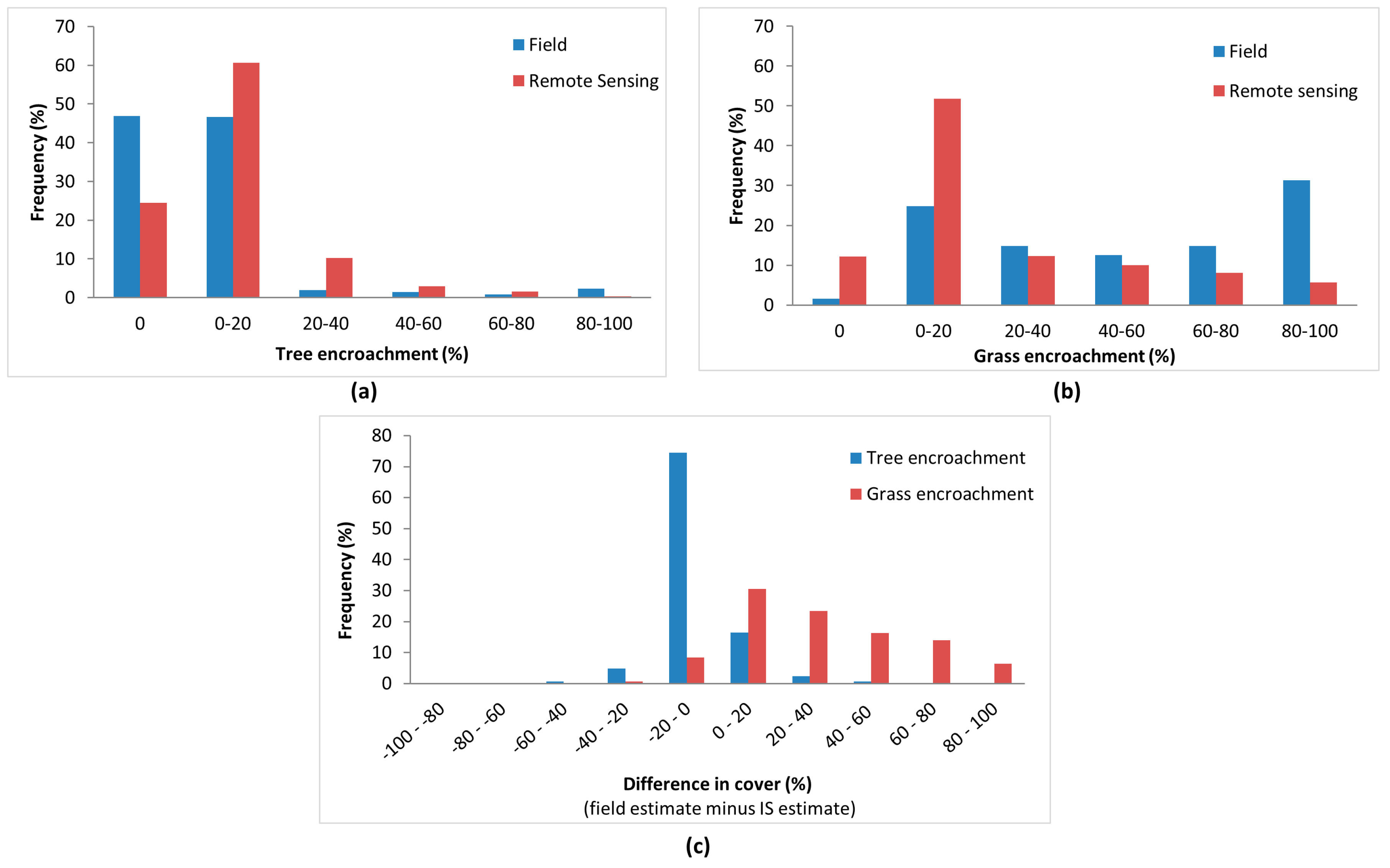
4. Discussion
5. Conclusions
Supplementary Materials
Acknowledgments
Author Contributions
Conflicts of Interest
References
- Council Directive 92/43/EEC of 21 May 1992 on the conservation of natural habitats and of wild fauna and flora. Off. J. Eur. Union 1992, L 206, 7–50.
- Council Directive 79/409/EEC of 2 April 1979 on the conservation of wild birds. Off. J. Eur. Union 1979, L 103, 1–18.
- Vanden Borre, J.; Paelinckx, D.; Mücher, C.A.; Kooistra, L.; Haest, B.; de Blust, G.; Schmidt, A.M. Integrating remote sensing in Natura 2000 habitat monitoring: Prospects on the way forward. J. Nat. Conserv. 2011, 19, 116–125. [Google Scholar] [CrossRef]
- Evans, D. The habitats of the European Union Habitats Directive. Biol. Environ. Proc. R. Irish Acad. 2006, 106, 167–173. [Google Scholar] [CrossRef]
- Bock, M.; Xofis, P.; Mitchley, J.; Rossner, G.; Wissen, M. Object-oriented methods for habitat mapping at multiple scales–Case studies from Northern Germany and Wye Downs, UK. J. Nat. Conserv. 2005, 13, 75–89. [Google Scholar] [CrossRef]
- Förster, M.; Frick, A.; Walentowski, H.; Kleinschmit, B. Approaches to utilising QuickBird data for the monitoring of NATURA 2000 habitats. Commun. Ecol. 2008, 9, 155–168. [Google Scholar] [CrossRef]
- Bobbink, R.; Hornung, M.; Roelofs, J.G.M. The effect of air-borne nitrogen pollutants on species diversity in natural and semi-natural European vegetation. J. Ecol. 1998, 86, 717–738. [Google Scholar] [CrossRef]
- Riksen, M.; Ketner-Oostra, R.; Turnhout, C.; Nijssen, M.; Goossens, D.; Jungerius, P.D.; Spaan, W. Will We Lose the Last Active Inland Drift Sands of Western Europe? The Origin and Development of the Inland Drift-sand Ecotype in the Netherlands. Landsc. Ecol. 2006, 21, 431–447. [Google Scholar] [CrossRef]
- Strange, N.; Jacobsen, J.B.; Thorsen, B.J.; Tarp, P. Value for money: Protecting endangered species on Danish heathland. Environ. Manag. 2007, 40, 761–774. [Google Scholar] [CrossRef] [PubMed]
- De Blust, G. Heathland, an ever changing landscape. In Europe’s Living Landscapes. Essays on Exploring Our Identity in the Countryside; Pedroli, B., Van Doorn, A., De Blust, G., Paracchini, M.L., Wascher, D., Bunce, F., Eds.; Landscape Europe & KNNV Publishing: Wageningen & Zeist, The Netherlands, 2007; pp. 178–192. [Google Scholar]
- Webb, N.R. The traditional management of European heathlands. J. Appl. Ecol. 1998, 35, 987–990. [Google Scholar] [CrossRef]
- Zlinszky, A.; Heilmeier, H.; Balzter, H.; Czúcz, B.; Pfeifer, N. Remote sensing and GIS for habitat quality monitoring: New approaches and future research. Remote Sens. 2015, 7, 7987–7994. [Google Scholar] [CrossRef] [Green Version]
- Nagendra, H.; Rocchini, D. High resolution satellite imagery for tropical biodiversity studies: The devil is in the detail. Biodivers. Conserv. 2008, 17, 3431–3442. [Google Scholar] [CrossRef]
- Burai, P.; Deák, B.; Valkó, O.; Tomor, T. Classification of Herbaceous Vegetation Using Airborne Hyperspectral Imagery. Remote Sens. 2015, 7, 2046–2066. [Google Scholar] [CrossRef]
- Nagendra, H.; Lucas, R.M.; Honrado, J.P.; Jongman, R.H.G.; Tarantino, C.; Adamo, M.; Mairota, P. Remote sensing for conservation monitoring: Assessing protected areas, habitat extent, habitat condition, species diversity, and threats. Ecol. Indic. 2013, 33, 45–59. [Google Scholar] [CrossRef]
- Skowronek, S.; Asner, G.P.; Feilhauer, H. Performance of one-class classifiers for invasive species mapping using airborne imaging spectroscopy. Ecol. Inform. 2017, 37, 66–76. [Google Scholar] [CrossRef]
- Skowronek, S.; Ewald, M.; Isermann, M.; van de Kerchove, R.; Lenoir, J.; Aerts, R.; Warrie, J.; Hattab, T.; Honnay, O.; Schmidtlein, S.; et al. Mapping an invasive bryophyte species using hyperspectral remote sensing data. Biol. Invasions 2016, 19, 1–16. [Google Scholar] [CrossRef]
- Oldeland, J.; Dorigo, W.; Wesuls, D.; Jürgens, N. Mapping bush encroaching species by seasonal differences in hyperspectral imagery. Remote Sens. 2010, 2, 1416–1438. [Google Scholar] [CrossRef]
- Möckel, T.; Dalmayne, J.; Schmid, B.; Prentice, H.; Hall, K. Airborne Hyperspectral Data Predict Fine-Scale Plant Species Diversity in Grazed Dry Grasslands. Remote Sens. 2016, 8, 133. [Google Scholar] [CrossRef]
- Schmidt, J.; Fassnacht, F.E.; Lausch, A.; Schmidtlein, S. Assessing the functional signature of heathland landscapes via hyperspectral remote sensing. Ecol. Indic. 2017, 73, 505–512. [Google Scholar] [CrossRef]
- Harris, A.; Charnock, R.; Lucas, R.M. Hyperspectral remote sensing of peatland floristic gradients. Remote Sens. Environ. 2015, 162, 99–111. [Google Scholar] [CrossRef]
- Stenzel, S.; Feilhauer, H.; Mack, B.; Metz, A.; Schmidtlein, S. Remote sensing of scattered natura 2000 habitats using a one-class classifier. Int. J. Appl. Earth Obs. Geoinf. 2014, 33, 211–217. [Google Scholar] [CrossRef]
- Feilhauer, H.; Dahlke, C.; Doktor, D.; Lausch, A.; Schmidtlein, S.; Schulz, G.; Stenzel, S. Mapping the local variability of Natura 2000 habitats with remote sensing. Appl. Veg. Sci. 2014, 17, 765–779. [Google Scholar] [CrossRef]
- Zlinszky, A.; Deák, B.; Kania, A.; Schroiff, A.; Pfeifer, N. Mapping Natura 2000 Habitat Conservation Status in a Pannonic Salt Steppe with Airborne Laser Scanning. Remote Sens. 2015, 7, 2991–3019. [Google Scholar] [CrossRef] [Green Version]
- Simonson, W.D.; Allen, H.D.; Coomes, D.A. Remotely sensed indicators of forest conservation status: Case study from a Natura 2000 site in southern Portugal. Ecol. Indic. 2013, 24, 636–647. [Google Scholar] [CrossRef]
- Delalieux, S.; Somers, B.; Haest, B.; Spanhove, T.; Vanden Borre, J.; Mücher, C.A.; Vanden Borre, J.; Mücher, C.A. Heathland conservation status mapping through integration of hyperspectral mixture analysis and decision tree classifiers. Remote Sens. Environ. 2012, 126, 222–231. [Google Scholar] [CrossRef]
- Spanhove, T.; Vanden Borre, J.; Delalieux, S.; Haest, B.; Paelinckx, D. Can remote sensing estimate fine-scale quality indicators of natural habitats? Ecol. Indic. 2012, 18, 403–412. [Google Scholar] [CrossRef]
- Mücher, C.A.; Kooistra, L.; Vermeulen, M.; Vanden Borre, J.; Haest, B.; Haveman, R. Quantifying structure of Natura 2000 heathland habitats using spectral mixture analysis and segmentation techniques on hyperspectral imagery. Ecol. Indic. 2013, 33, 71–81. [Google Scholar] [CrossRef]
- Neumann, C.; Weiss, G.; Schmidtlein, S.; Itzerott, S.; Lausch, A.; Doktor, D.; Brell, M. Gradient-Based Assessment of Habitat Quality for Spectral Ecosystem Monitoring. Remote Sens. 2015, 7, 2871–2898. [Google Scholar] [CrossRef]
- Haest, B.; Thoonen, G.; Vanden Borre, J.; Spanhove, T.; Delalieux, S.; Bertels, L.; Kooistra, L.; Mücher, C.A.; Scheunders, P. An object-based approach to quantity and quality assessment of heathland habitats in the framework of Natura 2000 using hyperspectral airborne AHS images. In The International Archives of the Photogrammetry, Remote Sensing and Spatial Information Sciences; International Society for Photogrammetry and Remote Sensing: Hannover, Germany, 2010; Volume XXXVIII-4/C7, pp. 1–6. [Google Scholar]
- De Blust, G.; Slootmaekers, M. De Kalmthoutse Heide; Davidsfonds: Leuven, Belgium, 1997. [Google Scholar]
- Jacquemyn, H.; Brys, R.; Neubert, M.G. Fire increases invasive spread of Molinia caerulea mainly through changes in demographic parameters. Ecol. Appl. 2005, 15, 2097–2108. [Google Scholar] [CrossRef]
- Louette, G.; De Knijf, G.; Anselin, A.; Devos, K.; Vermeersch, G.; Pollet, M.; Van Hove, M.; Paelinckx, D. Actualisatie van de Europese Standaardgegevensformulieren voor Vlaanderen in Uitvoering van de Europese Habitat- en Vogelrichtlijn. Rapport INBO.R.2015.7125262; Instituut voor Natuur- en Bosonderzoek: Brussels, Belgium, 2015. [Google Scholar]
- Bunce, R.G.H.; Bogers, M.M.B.; Evans, D.; Halada, L.; Jongman, R.H.G.; Mucher, C.A.; Bauch, B.; de Blust, G.; Parr, T.W.; Olsvig-Whittaker, L. The significance of habitats as indicators of biodiversity and their links to species. Ecol. Indic. 2013, 33, 19–25. [Google Scholar] [CrossRef]
- Bunce, R.G.H.; Metzger, M.J.; Jongman, R.H.G.; Brandt, J.; De Blust, G.; Elena-Rossello, R.; Groom, G.B.; Halada, L.; Hofer, G.; Howard, D.C.; et al. A standardized procedure for surveillance and monitoring European habitats and provision of spatial data. Landsc. Ecol. 2008, 23, 11–25. [Google Scholar] [CrossRef]
- Biesemans, J.; Sterckx, S.; Knaeps, E.; Vreys, K.; Adriaensen, S.; Hooyberghs, J.; Meuleman, K.; Kempeneers, P.; Deronde, B.; Everaerts, J.; et al. Image processing workflows for airborne remote sensing. In Proceedings of the 5th EARSEL Workshop on Imaging Spectroscopy, Bruges, Belgium, 23–25 April 2007.
- Biesemans, J.; Verbeke, B.; Vanderstraete, T.; van Der Linden, S.; van Camp, N. Prototype Workflow in Support of GRB Mutation and Anomaly Detection in the Framework of the GRB Update Process—Technical Report; Agentschap Geografische Informatie Vlaanderen: Brussels, Belgium, 2008. [Google Scholar]
- Ellmauer, T. Entwicklung von Kriterien, Indikatoren und Schwellenwerten zur Beurteilung des Erhaltungszustandes der Natura 2000-Schutzgüter. Band 3: Lebensraumtypen des Anhangs I der Fauna-Flora-Habitat-Richtlinie; Umweltbundesamt: Vienna, Austria, 2005. [Google Scholar]
- Heutz, G.; Paelinckx, D. Natura 2000 Habitats: Doelen en Staat van Instandhouding: Versie 1.0 (ontwerp) Onderzoeksverslag; Instituut voor Natuur- en Bosonderzoek: Brussels, Belgium, 2005. [Google Scholar]
- Verbücheln, G.; Börth, M.; Hinterlang, D.; Hübner, T.; Michels, C.; Neitzke, A.; König, H.; Pardey, A.; Raabe, U.; Röös, M.; et al. Anleitung zur Bewertung des Erhaltungszustandes von FFH-Lebensraumtypen; Landesanstalt für Ökologie, Bodenordnung und Forsten Nordrhein Westfalen: Recklinghausen, Germany, 2002. [Google Scholar]
- Søgaard, B.; Skov, F.; Ejrnæs, R.; Pihl, S.; Fredshavn, J.R.; Nielsen, K.E.; Clausen, P.; Laursen, K.; Bregnballe, T.; Madsen, J.; et al. Criteria for favourable conservation status in Denmark. Natural habitat types and species covered by the EEC Habitats Directive and birds covered by the EEC Birds Directive; National Environmental Research Institute: Aarhus, Denmark, 2007. [Google Scholar]
- European Commission. Interpretation Manual of European Union Habitats–EUR27; European Commission, Directorate-General Environment: Brussels, Belgium, 2007. [Google Scholar]
- Janssen, J.A.M.; Schaminée, J.H.J. Europese Natuur in Nederland: Habitattypen; KNNV Uitgeverij: Utrecht, The Netherlands, 2003. [Google Scholar]
- Sterckx, G.; Paelinckx, D.; Decleer, K.; De Saeger, S.; Provoost, S.; Denys, L.; Packet, J.; Wouters, J.; Demolder, H.; Thomaes, A.; et al. Habitattypen Bijlage 1 Habitatrichtlijn. In Europees Beschermde Natuur in Vlaanderen en het Belgisch Deel van de Noordzee. Habitattypen/Dier- en Plantensoorten; Decleer, K., Ed.; Research Institute for Nature and Forest: Brussels, Belgium, 2007; pp. 59–359. [Google Scholar]
- T’jollyn, F.; Bosch, H.; Demolder, H.; De Saeger, S.; Leyssen, A.; Thomaes, A.; Wouters, J.; Paelinckx, D.; Hoffman, M. Ontwikkeling van Criteria voor de Beoordeling van de Lokale Staat van Instandhouding van de Natura 2000 Habitattypen. Versie 2.0; Instituut voor Natuur- en Bosonderzoek: Brussels, Belgium, 2009. [Google Scholar]
- Hill, M.O.; Smilauer, P. TWINSPAN for Windows Version 2.3; Centre for Ecology and Hydrology: Huntingdon, UK; University of South Bohemia: Ceske Budejovice, Czech Republic, 2005. [Google Scholar]
- McCune, B.; Mefford, M.J. PC-ORD. Multivariate Analysis of Ecological Data. Version 5.12; MjM Software Design: Gleneden Beach, USA, 2006. [Google Scholar]
- Fisher, R.A. The use of multiple measurements in taxonomic problems. Ann. Eugen. 1936, 7, 179–188. [Google Scholar] [CrossRef]
- Pudil, P.; Novovičová, J.; Kittler, J. Floating search methods in feature selection. Pattern Recognit. Lett. 1994, 15, 1119–1125. [Google Scholar] [CrossRef]
- De Saeger, S.; Oosterlynck, P.; Guelinckx, R.; Paelinckx, D. BWK en Habitatkartering, een Praktische Handleiding. Deel 1: Methodologie: Karteerregels, Karteringseenheden en Hoofdsleutel. Versie1, maart 2016. Rapport INBO.R.2016.1161360; Instituut voor Natuur- en Bosonderzoek: Brussels, Belgium, 2016. [Google Scholar]
- Raunkiaer, C. The Life Forms of Plants and Statistical Plant Geography; Being the Collected Papers of C. Raunkiaer; Oxford University Press: Oxford, UK, 1934. [Google Scholar]
- Bunce, R.G.H.; Bogers, M.B.B.; Roche, P.; Walczak, M.; Geijzendorffer, I.R.; Jongman, R.H.G. Manual for Habitat and Vegetation Surveillance and Monitoring. Temperate, Mediterranean and Desert Biomes; Alterra Report 2154; Alterra: Wageningen, The Netherlands, 2011. [Google Scholar]
- Bunce, R.G.H.; Groom, G.B.; Jongman, R.H.G.; Padoa-Schioppa, E. Handbook for Surveillance and Monitoring of European Habitats; Alterra Report 1219; Alterra: Wageningen, The Netherlands, 2005. [Google Scholar]
- De Saeger, S.; Paelinckx, D.; Demolder, H.; Denys, L.; Packet, J.; Thomaes, A.; Vandekerkhove, K. Sleutel voor het Karteren van NATURA2000 Habitattypen in Vlaanderen, Grotendeels Vertrekkende van de Karteringseenheden van de Biologische Waarderingskaart, versie 5; Instituut voor Natuur- en Bosonderzoek: Brussels, Belgium, 2008. [Google Scholar]
- Kontula, T.; Raunio, A. New method and criteria for national assessments of threatened habitat types. Biodivers. Conserv. 2009, 18, 3861–3876. [Google Scholar] [CrossRef]
- Duin, R.P.W.; Juszczak, P.; Paclik, P.; Pekalska, E.; de Ridder, D.; Tax, D.M.J.; Verzakov, S. PRTools4.1, A Matlab Toolbox for Pattern Recognition; Delft University of Technology: Delft, The Netherlands, 2007. [Google Scholar]
- Hearn, S.M.; Healey, J.R.; McDonald, M.A.; Turner, A.J.; Wong, J.L.G.; Stewart, G.B. The repeatability of vegetation classification and mapping. J. Environ. Manag. 2011, 92, 1174–1184. [Google Scholar] [CrossRef] [PubMed]
- Vittoz, P.; Guisan, A. How reliable is the monitoring of permanent vegetation plots? A test with multiple observers. J. Veg. Sci. 2007, 18, 413–422. [Google Scholar] [CrossRef]
- Madonsela, S.; Cho, M.A.; Mathieu, R.; Mutanga, O.; Ramoelo, A.; Kaszta, Ż.; Van De Kerchove, R.; Wolff, E. Multi-phenology WorldView-2 imagery improves remote sensing of savannah tree species. Int. J. Appl. Earth Obs. Geoinf. 2017, 58, 65–73. [Google Scholar] [CrossRef]
- Yu, Q.; Gong, P.; Clinton, N.; Biging, G.; Kelly, M.; Schirokauer, D. Object-based Detailed Vegetation Classification with Airborne High Spatial Resolution Remote Sensing Imagery. Photogramm. Eng. Remote Sens. 2006, 72, 799–811. [Google Scholar] [CrossRef]
- Luft, L.; Neumann, C.; Freude, M.; Blaum, N.; Jeltsch, F. Hyperspectral modeling of ecological indicators - A new approach for monitoring former military training areas. Ecol. Indic. 2014, 46, 264–285. [Google Scholar] [CrossRef]
- Jacobs, J.-P.; Thoonen, G.; Tuia, D.; Camps-valls, G.; Haest, B.; Scheunders, P. Domain adaptation with hidden Markov Random Fields. In Proceedings of the IEEE International Geoscience and Remote Sensing Symposium, IGARSS 2013, Melbourne, Australia, 21–26 July 2013.


| Habitats Directive Habitat Code | Habitat Type | Areal Cover (Hectare) [33] |
|---|---|---|
| 2310 | Dry sand heaths with Calluna and Genista | ca. 250 ha |
| 2330 | Inland dunes with open Corynephorus and Agrostis grasslands | ca. 40 ha |
| 4010 | Northern Atlantic wet heaths with Erica tetralix | ca. 450 ha |
| 4030 | European dry heaths | ca. 60 ha |
| Level 1 | Level 2 | Level 3 | Level 4 | ||||
|---|---|---|---|---|---|---|---|
| H | Heathland | Hd | Dry heathland | Hdc | Calluna-dominated heathland | Hdcy | Calluna-stand of predominantly young age |
| Hdca | Calluna-stand of predominantly adult age | ||||||
| Hdco | Calluna-stand of predominantly old age (open) | ||||||
| Hdcm | Calluna-stand of 2 or 3 mixed age classes | ||||||
| Hw | Wet heathland | Hwe | Erica-dominated heathland | Hwe- | Erica-dominated heathland | ||
| Hg | Grass-encroached heathland | Hgm | Molinia-dominated heathland | Hgmd | Molinia-stand on dry soil | ||
| Hgmw | Molinia-stand on moist (wet) soil | ||||||
| G | Grassland | Gt | Temporary grassland | Gt- | Temporary grassland | Gt-- | Temporary grassland |
| Gp | Permanent grassland | Gpa | Permanent grassland in intensive agricultural use | Gpap | Species-poor permanent agricultural grassland | ||
| Gpar | Species-rich permanent agricultural grassland | ||||||
| Gpn | Permanent grassland with semi-natural vegetation | Gpnd | Dry semi-natural permanent grassland | ||||
| Gpj | Juncus effusus-dominated grassland | Gpj- | Juncus effusus-dominated grassland | ||||
| F | Forest | Fc | Coniferous forest | Fcp | Pine (Pinus sp.) forest | Fcpc | Corsican pine (Pinus nigra laricio) |
| Fcps | Scots pine (Pinus sylvestris) | ||||||
| Fd | Deciduous forest | Fdb | Birch (Betula sp.) forest | Fdb- | Birch (Betula pendula/pubescens) | ||
| Fdq | Oak (Quercus sp.) forest | Fdqz | Pedunculate oak (Quercus robur) | ||||
| S | Sand dune | Sb | Bare sand | Sb- | Bare sand | Sb-- | Bare sand |
| Sf | Fixed sand dune | Sfg | Sand dune with grasses as important fixators | Sfgm | Sand dune fixed by grasses and mosses | ||
| Sfm | Sand dune with mosses as dominating fixators | Sfmc | Fixed sand dune with predominantly Campylopus introflexus | ||||
| Sfmp | Fixed sand dune with predominantly Polytrichum piliferum | ||||||
| W | Water body | Wo | Oligotrophic water body | Wov | Shallow, vegetated oligotrophic water body (banks of pools) | Wov- | Shallow, vegetated oligotrophic water body (banks of pools) |
| Wou | Unvegetated (deep) oligotrophic water (centre of pools) | Wou- | Unvegetated (deep) oligotrophic water (centre of pools) | ||||
| A | Arable fields | Ac | Arable field with crop | Acm | Arable field—maize | Acm- | Arable field—maize |
| Aco | Arable field—other crops | Aco- | Arable field—other crops | ||||
| Super-Category | Life Form | Full Name | Explanation/Examples |
|---|---|---|---|
| SPV | Sparsely vegetated | Less than 30% vegetation cover | |
| AQU | Aquatic | Permanent water bodies | |
| TER | Terrestrial | Bare ground (sand) | |
| CUL | Cultivated | Cultivated land | |
| CRO | Herbaceous crops | e.g., Maize | |
| HER | Herbaceous | Non-woody vegetation | |
| HEL | Helophytes | Plants that grow in waterlogged conditions e.g., Juncus effusus | |
| LHE | Leafy hemicryptophytes | Biannual or perennial broadleaved herbaceous plant species (‘forbs’) | |
| CHE | Caespitose hemicryptophytes | Perennial monocotyledonous grasses, sedges and rushes e.g., Molinia caerulea | |
| CRY | Cryptogams | Bryophytes and lichens e.g., Campylopus introflexus | |
| TRS | Trees and shrubs | Woody vegetation | |
| SCH/EVR | Shrubby chamaephytes (evergreen) | Undershrubs with height 5 to 30 cm. e.g., Erica tetralix, young Calluna vulgaris | |
| LPH/EVR | Low phanerophytes (evergreen) | Low shrubs, buds between 30 and 60 cm. e.g., adult Calluna vulgaris | |
| FPH/CON | Forest phanerophytes (coniferous) | Coniferous trees between 5 and 40 m. e.g., Pinus sylvestris | |
| FPH/DEC | Forest phanerophytes (winter deciduous) | Broadleaved, winter deciduous trees between 5 and 40 m. e.g., Quercus robur |
| CRO | FPH_CON | FPH_DEC | LPH_EVR | SCH_EVR | CHE | CRY | HEL | TER | AQU | LHE | |
|---|---|---|---|---|---|---|---|---|---|---|---|
| Acm_ | 100 | ||||||||||
| Aco_ | 100 | ||||||||||
| Fcpc | 50 | 50 | |||||||||
| Fcps | 50 | 50 | |||||||||
| Fdb_ | 70 | 30 | |||||||||
| Fdqz | 100 | ||||||||||
| Gpap | 80 | 20 | |||||||||
| Gpar | 50 | 50 | |||||||||
| Gpj_ | 50 | 50 | |||||||||
| Gpnd | 50 | 50 | |||||||||
| Gt__ | 100 | ||||||||||
| Hdca | 80 | 10 | 10 | ||||||||
| Hdcm | 80 | 10 | 10 | ||||||||
| Hdco | 60 | 10 | 30 | ||||||||
| Hdcy | 80 | 10 | 10 | ||||||||
| Hgmd | 100 | ||||||||||
| Hgmw | 100 | ||||||||||
| Hwe_ | 50 | 50 | |||||||||
| Sb__ | 100 | ||||||||||
| Sfgm | 10 | 60 | 30 | ||||||||
| Sfmc | 80 | 20 | |||||||||
| Sfmp | 80 | 20 | |||||||||
| Wou_ | 100 | ||||||||||
| Wov_ | 30 | 70 |
| Definitions | SPV | = | AQU | + | TER | |||||||
| FPH | = | FPH_CON | + | FPH_DEC | ||||||||
| TRS | = | FPH_CON | + | FPH_DEC | + | LPH_EVR | + | SCH_EVR | ||||
| HER | = | HEL | + | LHE | + | CHE | + | CRY | ||||
| Life Form | Rule | General Habitat Category (GHC) 1 | Rule | |||||||||
| CRO × 100 | >50 | Unspecified | ||||||||||
| SPV × 100 | >=30 | Highest (e.g., AQU, TER) | ||||||||||
| Highest_2ndHighest (e.g., AQU/TER, TER/AQU) | ||||||||||||
| TRS × 100 | >=30 | FirstNonZero_Highest (e.g., FPH_CON) | ||||||||||
| FirstNonZero_ HighestNonZero/2ndHighestNonZero (DEC, EVR, CON) (e.g., FPH_DEC/CON) | ||||||||||||
| >=30 | Unspecified | |||||||||||
| <30 | Highest (e.g., CHE, CRY) | |||||||||||
| Highest_2ndHighest (e.g., CHE/LHE) | ||||||||||||
| Habitat | 2310 | 2330 | 4010 | 4030 |
|---|---|---|---|---|
| H | 30–100 | 0–50 | 70–100 | 50–100 |
| Hd | 0–100 | 0–50 | 0–50 | 0–100 |
| Hw | 0–50 | 0–10 | 0–100 | 0–50 |
| Hg | 0–50 | 0–50 | 0–50 | 0–50 |
| Hgmw | 0–30 | 0–10 | 0–50 | 0–30 |
| Hgmd | 0–50 | 0–50 | 0–30 | 0–50 |
| S | 0–70 | 0–100 | 0–10 | 0–30 |
| G | 0–70 | 0–100 | 0–10 | 0–30 |
| Gpnd | 0–70 | 0–100 | 0–10 | 0–30 |
| Gpj | 0–10 | 0–10 | 0–10 | 0–10 |
| Gpa | 0–10 | 0–10 | 0–10 | 0–10 |
| Gt | 0–10 | 0–10 | 0–10 | 0–10 |
| S + Gpnd | 0–70 | 50–100 | 0–10 | 0–30 |
| F | 0–30 | 0–15 | 0–30 | 0–30 |
| W | 0–10 | 0–10 | 0–30 | 0–10 |
| A | 0–10 | 0–10 | 0–10 | 0–10 |
| Hw − Hd | negative | negative | positive | negative |
| minimum patch size (m2) | 400 | 400 | 400 | 400 |
| Level | Number of Classes | Non-Hierarchical | Hierarchical L1 → L4 | Hierarchical L2 → L4 | |||
|---|---|---|---|---|---|---|---|
| OA (%) | Kappa | OA (%) | Kappa | OA (%) | Kappa | ||
| 1 | 6 | 93.82 | 0.93 | 93.82 | 0.93 | - | - |
| 2 | 11 | 91.68 | 0.91 | 90.19 | 0.89 | 91.68 | 0.91 |
| 3 | 17 | 88.17 | 0.87 | 87.10 | 0.86 | 88.59 | 0.88 |
| 4 | 24 | 81.77 | 0.80 | 81.24 | 0.80 | 82.84 | 0.82 |
| Level 2 | Level 3 | Level 4 | |||||||||
|---|---|---|---|---|---|---|---|---|---|---|---|
| Class | # of Reference Plots | UA | PA | Class | # of Reference Plots | UA | PA | Class | # of Reference Plots | UA | PA |
| Ac | 133 | 96.77 | 90.23 | Acm | 98 | 87.62 | 93.88 | Acm- | 98 | 87.62 | 93.88 |
| Aco | 35 | 100.00 | 54.29 | Aco- | 35 | 100.00 | 54.29 | ||||
| Fc | 97 | 93.75 | 92.78 | Fcp | 97 | 93.75 | 92.78 | Fcpc | 44 | 70.21 | 75.00 |
| Fcps | 53 | 79.59 | 73.58 | ||||||||
| Fd | 80 | 93.90 | 96.25 | Fdb | 32 | 90.63 | 90.63 | Fdb- | 32 | 90.63 | 90.63 |
| Fdq | 48 | 94.00 | 97.92 | Fdqz | 48 | 94.00 | 97.92 | ||||
| Gp | 66 | 91.07 | 77.27 | Gpa | 25 | 62.50 | 60.00 | Gpap | 12 | 50.00 | 41.67 |
| Gpar | 13 | 35.71 | 38.46 | ||||||||
| Gpj | 18 | 54.55 | 33.33 | Gpj- | 18 | 54.55 | 33.33 | ||||
| Gpn | 23 | 90.48 | 82.61 | Gpnd | 23 | 90.48 | 82.61 | ||||
| Gt | 97 | 94.90 | 95.88 | Gt- | 97 | 94.90 | 95.88 | Gt-- | 97 | 94.90 | 95.88 |
| Hd | 84 | 85.39 | 90.48 | Hdc | 84 | 85.39 | 90.48 | Hdca | 28 | 68.97 | 71.43 |
| Hdcm | 23 | 60.00 | 65.22 | ||||||||
| Hdco | 8 | 44.44 | 50.00 | ||||||||
| Hdcy | 25 | 65.38 | 68.00 | ||||||||
| Hg | 25 | 85.19 | 92.00 | Hgm | 25 | 85.19 | 92.00 | Hgmd | 15 | 68.75 | 73.33 |
| Hgmw | 10 | 72.73 | 80.00 | ||||||||
| Hw | 88 | 84.09 | 84.09 | Hwe | 88 | 84.09 | 84.09 | Hwe- | 88 | 84.09 | 84.09 |
| Sb | 104 | 96.08 | 94.23 | Sb- | 104 | 96.08 | 94.23 | Sb-- | 104 | 96.08 | 94.23 |
| Sf | 62 | 89.39 | 95.16 | Sfg | 14 | 76.92 | 71.43 | Sfgm | 14 | 76.92 | 71.43 |
| Sfm | 48 | 86.79 | 95.83 | Sfmc | 40 | 77.08 | 92.50 | ||||
| Sfmp | 8 | 40.00 | 25.00 | ||||||||
| Wo | 102 | 90.00 | 97.06 | Wou | 45 | 84.62 | 97.78 | Wou- | 45 | 84.62 | 97.78 |
| Wov | 57 | 86.21 | 87.72 | Wov- | 57 | 86.21 | 87.72 | ||||
| Total: | 938 | Total: | 938 | Total: | 938 | ||||||
| Reference Data | Classified Data | |||||||||||||||||||||||||
|---|---|---|---|---|---|---|---|---|---|---|---|---|---|---|---|---|---|---|---|---|---|---|---|---|---|---|
| Acm- | Aco- | Fcpc | Fcps | Fdb- | Fdqz | Gpap | Gpar | Gpj- | Gpnd | Gt-- | Hdca | Hdcm | Hdco | Hdcy | Hgmd | Hgmw | Hwe- | Sb-- | Sfgm | Sfmc | Sfmp | Wou- | Wov- | Total | PA | |
| Acm- | 92 | 0 | 0 | 0 | 0 | 0 | 0 | 0 | 0 | 0 | 1 | 0 | 0 | 0 | 0 | 0 | 1 | 0 | 2 | 0 | 0 | 0 | 1 | 1 | 98 | 93.88 |
| Aco- | 9 | 19 | 1 | 0 | 0 | 3 | 0 | 1 | 0 | 0 | 0 | 0 | 0 | 0 | 0 | 1 | 0 | 0 | 0 | 0 | 0 | 0 | 0 | 1 | 35 | 54.29 |
| Fcpc | 0 | 0 | 33 | 8 | 1 | 0 | 0 | 0 | 0 | 0 | 0 | 0 | 0 | 0 | 0 | 0 | 0 | 1 | 0 | 0 | 0 | 0 | 1 | 0 | 44 | 75.00 |
| Fcps | 0 | 0 | 10 | 39 | 0 | 0 | 0 | 0 | 0 | 0 | 0 | 0 | 0 | 0 | 0 | 0 | 0 | 4 | 0 | 0 | 0 | 0 | 0 | 0 | 53 | 73.58 |
| Fdb- | 0 | 0 | 3 | 0 | 29 | 0 | 0 | 0 | 0 | 0 | 0 | 0 | 0 | 0 | 0 | 0 | 0 | 0 | 0 | 0 | 0 | 0 | 0 | 0 | 32 | 90.63 |
| Fdqz | 0 | 0 | 0 | 0 | 1 | 47 | 0 | 0 | 0 | 0 | 0 | 0 | 0 | 0 | 0 | 0 | 0 | 0 | 0 | 0 | 0 | 0 | 0 | 0 | 48 | 97.92 |
| Gpap | 0 | 0 | 0 | 0 | 0 | 0 | 5 | 2 | 0 | 1 | 4 | 0 | 0 | 0 | 0 | 0 | 0 | 0 | 0 | 0 | 0 | 0 | 0 | 0 | 12 | 41.67 |
| Gpar | 0 | 0 | 0 | 0 | 1 | 0 | 3 | 5 | 4 | 0 | 0 | 0 | 0 | 0 | 0 | 0 | 0 | 0 | 0 | 0 | 0 | 0 | 0 | 0 | 13 | 38.46 |
| Gpj- | 0 | 0 | 0 | 1 | 0 | 0 | 1 | 4 | 6 | 0 | 0 | 0 | 0 | 0 | 0 | 0 | 0 | 1 | 0 | 0 | 2 | 0 | 0 | 3 | 18 | 33.33 |
| Gpnd | 0 | 0 | 0 | 0 | 0 | 0 | 1 | 0 | 0 | 19 | 0 | 0 | 0 | 0 | 1 | 0 | 0 | 1 | 0 | 1 | 0 | 0 | 0 | 0 | 23 | 82.61 |
| Gt-- | 0 | 0 | 0 | 0 | 0 | 0 | 0 | 2 | 0 | 0 | 93 | 0 | 0 | 0 | 0 | 1 | 0 | 0 | 0 | 0 | 0 | 0 | 1 | 0 | 97 | 95.88 |
| Hdca | 0 | 0 | 0 | 0 | 0 | 0 | 0 | 0 | 0 | 0 | 0 | 20 | 5 | 1 | 1 | 0 | 0 | 1 | 0 | 0 | 0 | 0 | 0 | 0 | 28 | 71.43 |
| Hdcm | 0 | 0 | 0 | 0 | 0 | 0 | 0 | 0 | 0 | 0 | 0 | 4 | 15 | 0 | 3 | 0 | 0 | 1 | 0 | 0 | 0 | 0 | 0 | 0 | 23 | 65.22 |
| Hdco | 0 | 0 | 0 | 0 | 0 | 0 | 0 | 0 | 0 | 0 | 0 | 0 | 1 | 4 | 0 | 0 | 0 | 1 | 0 | 0 | 1 | 0 | 0 | 1 | 8 | 50.00 |
| Hdcy | 0 | 0 | 0 | 0 | 0 | 0 | 0 | 0 | 1 | 0 | 0 | 2 | 3 | 0 | 17 | 0 | 0 | 2 | 0 | 0 | 0 | 0 | 0 | 0 | 25 | 68.00 |
| Hgmd | 0 | 0 | 0 | 0 | 0 | 0 | 0 | 0 | 0 | 0 | 0 | 0 | 0 | 0 | 0 | 11 | 2 | 1 | 0 | 0 | 0 | 0 | 0 | 1 | 15 | 73.33 |
| Hgmw | 0 | 0 | 0 | 0 | 0 | 0 | 0 | 0 | 0 | 0 | 0 | 0 | 0 | 0 | 0 | 2 | 8 | 0 | 0 | 0 | 0 | 0 | 0 | 0 | 10 | 80.00 |
| Hwe- | 0 | 0 | 0 | 0 | 0 | 0 | 0 | 0 | 0 | 0 | 0 | 3 | 1 | 3 | 4 | 1 | 0 | 74 | 0 | 0 | 1 | 0 | 0 | 1 | 88 | 84.09 |
| Sb-- | 4 | 0 | 0 | 0 | 0 | 0 | 0 | 0 | 0 | 0 | 0 | 0 | 0 | 0 | 0 | 0 | 0 | 0 | 98 | 1 | 1 | 0 | 0 | 0 | 104 | 94.23 |
| Sfgm | 0 | 0 | 0 | 0 | 0 | 0 | 0 | 0 | 0 | 0 | 0 | 0 | 0 | 0 | 0 | 0 | 0 | 0 | 2 | 10 | 1 | 1 | 0 | 0 | 14 | 71.43 |
| Sfmc | 0 | 0 | 0 | 0 | 0 | 0 | 0 | 0 | 0 | 0 | 0 | 0 | 0 | 1 | 0 | 0 | 0 | 0 | 0 | 0 | 37 | 2 | 0 | 0 | 40 | 92.50 |
| Sfmp | 0 | 0 | 0 | 0 | 0 | 0 | 0 | 0 | 0 | 0 | 0 | 0 | 0 | 0 | 0 | 0 | 0 | 0 | 0 | 1 | 5 | 2 | 0 | 0 | 8 | 25.00 |
| Wou- | 0 | 0 | 0 | 0 | 0 | 0 | 0 | 0 | 0 | 1 | 0 | 0 | 0 | 0 | 0 | 0 | 0 | 0 | 0 | 0 | 0 | 0 | 44 | 0 | 45 | 97.78 |
| Wov- | 0 | 0 | 0 | 1 | 0 | 0 | 0 | 0 | 0 | 0 | 0 | 0 | 0 | 0 | 0 | 0 | 0 | 1 | 0 | 0 | 0 | 0 | 5 | 50 | 57 | 87.72 |
| Total | 105 | 19 | 47 | 49 | 32 | 50 | 10 | 14 | 11 | 21 | 98 | 29 | 25 | 9 | 26 | 16 | 11 | 88 | 102 | 13 | 48 | 5 | 52 | 58 | ||
| UA | 87.62 | 100.00 | 70.21 | 79.59 | 90.63 | 94.00 | 50.00 | 35.71 | 54.55 | 90.48 | 94.90 | 68.97 | 60.00 | 44.44 | 65.38 | 68.75 | 72.73 | 84.09 | 96.08 | 76.92 | 77.08 | 40.00 | 84.62 | 86.21 | ||
| Mapped | |||||||
|---|---|---|---|---|---|---|---|
| Field | No N2000 Habitat | 2310 | 2330 | 4010 | 4030 | # of Reference Plots | PA (%) |
| No N2000 Habitat | 542 | 1 | 4 | 3 | 0 | 550 | 98.55 |
| 2310 | 3 | 48 | 2 | 13 | 0 | 66 | 72.73 |
| 2330 | 24 | 9 | 143 | 1 | 0 | 177 | 80.79 |
| 4010 | 6 | 12 | 0 | 81 | 0 | 99 | 81.82 |
| 4030 | 15 | 0 | 3 | 3 | 25 | 46 | 54.35 |
| # of reference plots | 590 | 70 | 152 | 101 | 25 | 938 | |
| UA (%) | 91.86 | 68.57 | 94.08 | 80.20 | 100.00 | OA = | 89.45% |
© 2017 by the authors. Licensee MDPI, Basel, Switzerland. This article is an open access article distributed under the terms and conditions of the Creative Commons Attribution (CC BY) license ( http://creativecommons.org/licenses/by/4.0/).
Share and Cite
Haest, B.; Vanden Borre, J.; Spanhove, T.; Thoonen, G.; Delalieux, S.; Kooistra, L.; Mücher, C.A.; Paelinckx, D.; Scheunders, P.; Kempeneers, P. Habitat Mapping and Quality Assessment of NATURA 2000 Heathland Using Airborne Imaging Spectroscopy. Remote Sens. 2017, 9, 266. https://doi.org/10.3390/rs9030266
Haest B, Vanden Borre J, Spanhove T, Thoonen G, Delalieux S, Kooistra L, Mücher CA, Paelinckx D, Scheunders P, Kempeneers P. Habitat Mapping and Quality Assessment of NATURA 2000 Heathland Using Airborne Imaging Spectroscopy. Remote Sensing. 2017; 9(3):266. https://doi.org/10.3390/rs9030266
Chicago/Turabian StyleHaest, Birgen, Jeroen Vanden Borre, Toon Spanhove, Guy Thoonen, Stephanie Delalieux, Lammert Kooistra, Caspar A. Mücher, Desiré Paelinckx, Paul Scheunders, and Pieter Kempeneers. 2017. "Habitat Mapping and Quality Assessment of NATURA 2000 Heathland Using Airborne Imaging Spectroscopy" Remote Sensing 9, no. 3: 266. https://doi.org/10.3390/rs9030266
APA StyleHaest, B., Vanden Borre, J., Spanhove, T., Thoonen, G., Delalieux, S., Kooistra, L., Mücher, C. A., Paelinckx, D., Scheunders, P., & Kempeneers, P. (2017). Habitat Mapping and Quality Assessment of NATURA 2000 Heathland Using Airborne Imaging Spectroscopy. Remote Sensing, 9(3), 266. https://doi.org/10.3390/rs9030266