
Complementary Use of Ground-Based Proximal Sensing and Airborne/Spaceborne Remote Sensing Techniques in Precision Agriculture: A Systematic Review

 ,
, 
 , and
, and 
Abstract
:1. Introduction
- RQ1 What are the challenges of the three technologies that this work deals with?
- RQ2 How can these three technologies be used in a complementary way so as to facilitate the transition to Agriculture 4.0?
2. Overview of Sensing Technologies
2.1. Ground-Based Sensing
2.2. Remote Sensing Techniques
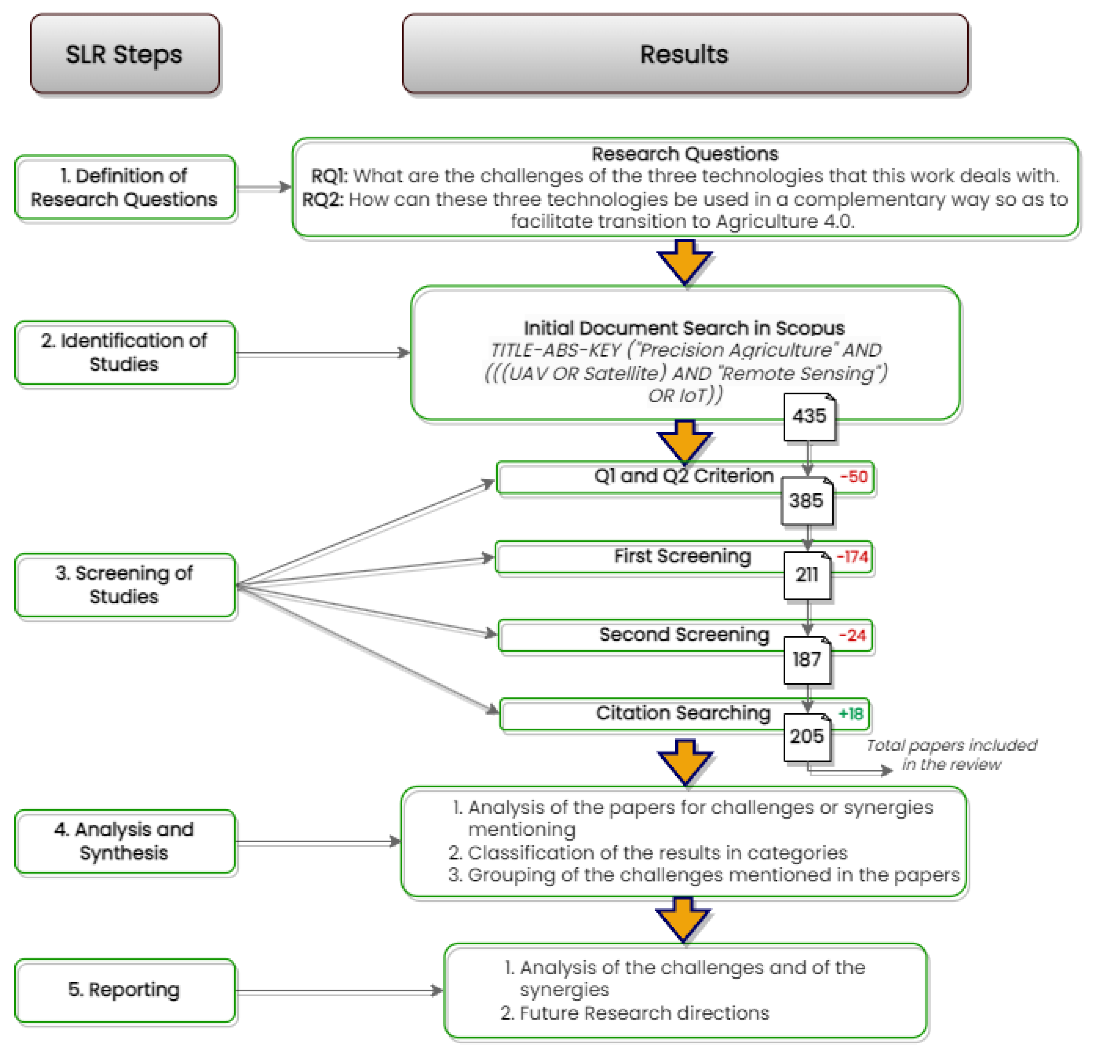
3. Methodology
TITLE-ABS-KEY (“Precision Agriculture” AND (((UAV OR Satellite) AND “Remote Sensing”) OR IoT))
- Should be written in English,
- Should be published after 2017,
- Should be published in Q1 and Q2 journals.
4. Results
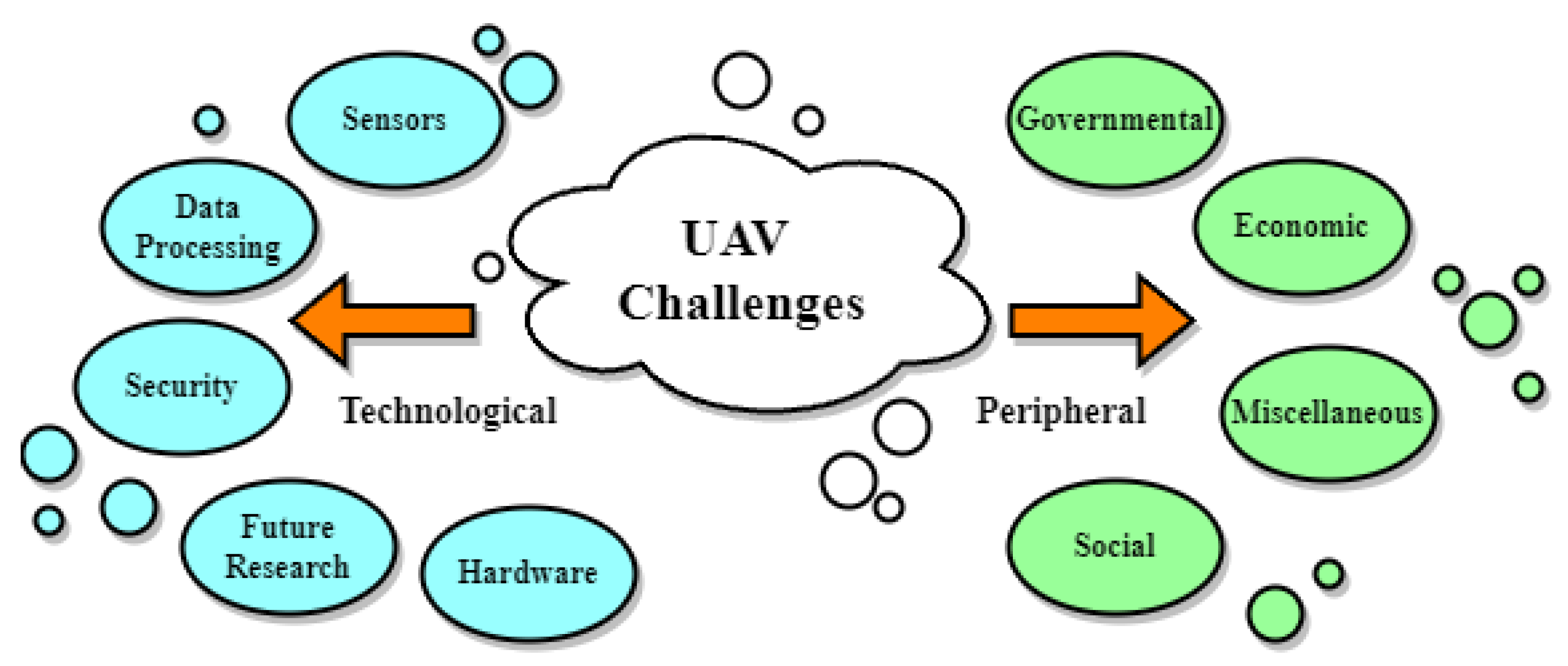
4.1. UAV Challenges
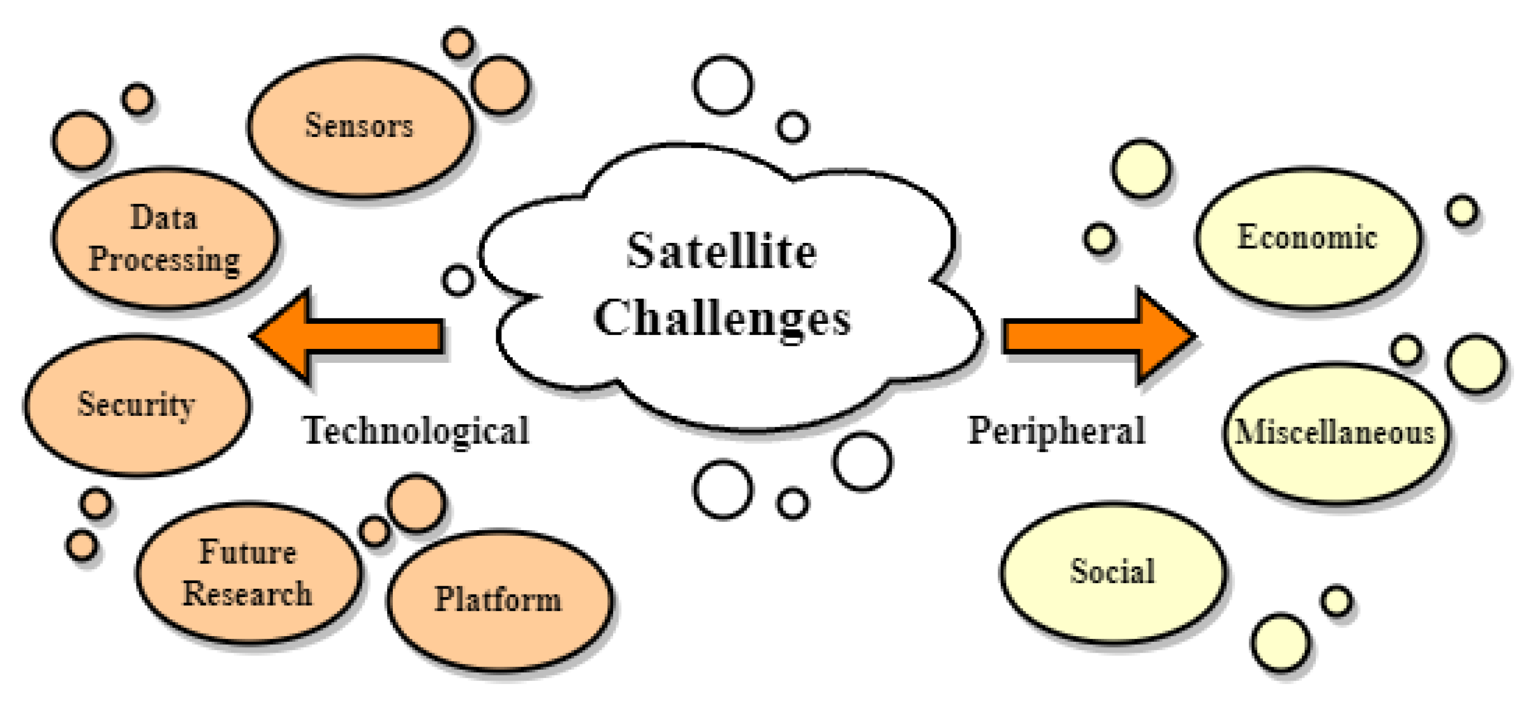
4.2. Satellite Challenges
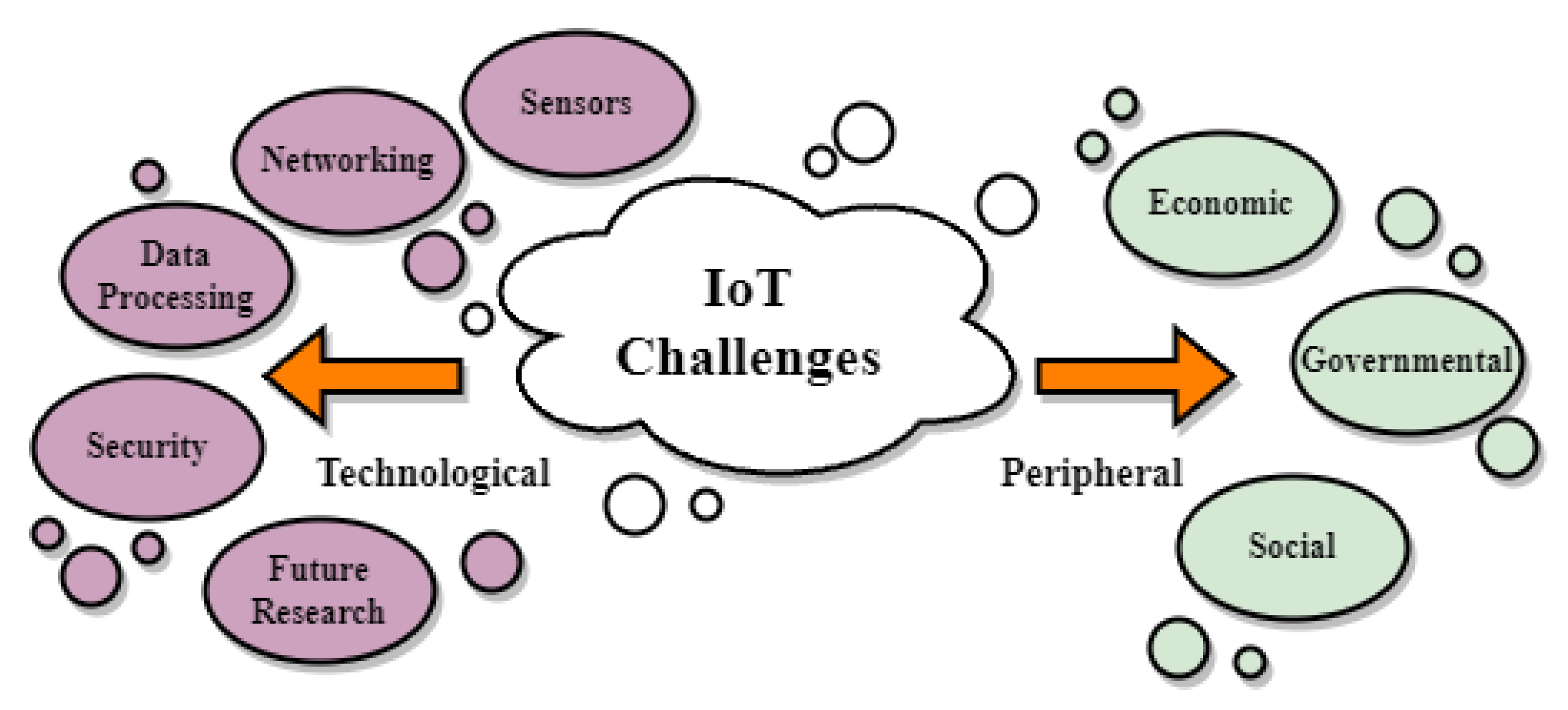
4.3. IoT Challenges
4.4. Synergies Mentioned in the Literature
5. Discussion
6. Conclusions
- Satellite is the broadest of the three technologies, providing ample farm coverage and good image detail. Cost-wise, it is the least risky source of PA data out of the three technologies, but it is also the slowest to provide usable results.
- UAVs have great flexibility and the capability to provide very specific information, but they are costly when applied to large farms, while also requiring a risky upfront investment from farmers. Their ability to analyze crops in very fine detail allows them to deal with specialized problems such as diseases or wild weeds. Still, using them is far from a standardized procedure, and more research is needed to establish the UAVs as a definitive solution.
- IoT provides the most specific information, as it can be tailored to the particular crop and farm. Moreover, it takes the smallest amount of time for data processing and has the unique potential of constant field monitoring. Its high specialization comes at the cost of reduced flexibility and area coverage.
- The review process included reviewing 24 use cases of synergies in the domain of agriculture between the technologies in question. Open challenges setting the ground for future research include data privacy issues, large data volumes, data fusion, farmers’ acquaintance with the technology, and lack of standardization. Taking steps toward addressing such challenges could facilitate further synergies and help the agricultural domain advance toward the Agriculture 4.0 paradigm.
Author Contributions
Funding
Data Availability Statement
Conflicts of Interest
Abbreviations
| UAV | Unmanned Aerial Vehicle |
| IoT | Internet of Things |
| WSN | Wireless Sensor Network |
| PA | Precision Agriculture |
| IIoT | Industrial Internet of Things |
| ETO | Evapotranspiration |
| UN | United Nations |
| FAO | Food and Agriculture Organization |
| LVDT | Linear Variable Differential Transformer |
| LiDAR | Light Detection and Ranging |
| DSS | Decision Support System |
| LoRAWAN | Long Range Wide Area Network |
| NB-IoT | Narrow Band IoT |
| RGB | Red-Green-Blue |
| NIR | Near Infrared |
| IR | Infrared |
| MS | Multispectral |
| HS | Hyperspectral |
| LAI | Leaf Area Index |
| NDVI | Normalized Difference Vegetation Index |
| ML | Machine Learning |
| VHR | Very High Resolution |
| SfM | Structure from Motion |
| PRISMA | Preferred Reporting Items for Systematic Reviews and Meta-Analyses |
References
- De Clercq, M.; Vats, A.; Biel, A. Agriculture 4.0: The future of farming technology. In Proceedings of the World Government Summit, Dubai, United Arab Emirates, 17 January 2018; pp. 11–13. [Google Scholar]
- Leakey, R.R. Addressing the causes of land degradation, food/nutritional insecurity and poverty: A new approach to agricultural intensification in the tropics and sub-tropics. In Trade and Environment Review 2013: Wake Up Before it is too Late: Make Agriculture Truly Sustainable Now for Food Security in a Changing Climate; UN Publication: Geneva, Switzerland, 2013. [Google Scholar]
- Ray, D.K.; West, P.C.; Clark, M.; Gerber, J.S.; Prishchepov, A.V.; Chatterjee, S. Climate change has likely already affected global food production. PLoS ONE 2019, 14, e0217148. [Google Scholar] [CrossRef] [PubMed]
- Caldeira, C.; De Laurentiis, V.; Corrado, S.; van Holsteijn, F.; Sala, S. Quantification of food waste per product group along the food supply chain in the European Union: A mass flow analysis. Resour. Conserv. Recycl. 2019, 149, 479–488. [Google Scholar] [CrossRef]
- Rose, D.C.; Chilvers, J. Agriculture 4.0: Broadening responsible innovation in an era of smart farming. Front. Sustain. Food Syst. 2018, 2, 87. [Google Scholar] [CrossRef] [Green Version]
- Liu, Y.; Ma, X.; Shu, L.; Hancke, G.P.; Abu-Mahfouz, A.M. From Industry 4.0 to Agriculture 4.0: Current status, enabling technologies, and research challenges. IEEE Trans. Ind. Inform. 2020, 17, 4322–4334. [Google Scholar] [CrossRef]
- Mylonas, G.; Kalogeras, A.; Kalogeras, G.; Anagnostopoulos, C.; Alexakos, C.; Muñoz, L. Digital twins from smart manufacturing to smart cities: A survey. IEEE Access 2021, 9, 143222–143249. [Google Scholar] [CrossRef]
- Kalogeras, A.P.; Rivano, H.; Ferrarini, L.; Alexakos, C.; Iova, O.; Rastegarpour, S.; Mbacké, A.A. Cyber physical systems and Internet of Things: Emerging paradigms on smart cities. In Proceedings of the 2019 First International Conference on Societal Automation (SA), Krakow, Poland, 4–6 September 2019; pp. 1–13. [Google Scholar]
- Koulamas, C.; Kalogeras, A. Cyber-physical systems and digital twins in the industrial internet of things [cyber-physical systems]. Computer 2018, 51, 95–98. [Google Scholar] [CrossRef]
- Kalogeras, G.; Anagnostopoulos, C.; Alexakos, C.; Kalogeras, A.; Mylonas, G. Cyber Physical Systems for Smarter Society: A use case in the manufacturing sector. In Proceedings of the 2021 IEEE International Conference on Smart Internet of Things (SmartIoT), Jeju, Republic of Korea, 13–15 August 2021; pp. 371–376. [Google Scholar]
- Fountas, S.; Aggelopoulou, K.; Gemtos, T.A. Precision agriculture: Crop management for improved productivity and reduced environmental impact or improved sustainability. In Supply Chain Management for Sustainable Food Networks; John Wiley & Sons: Hoboken, NJ, USA, 2015; pp. 41–65. [Google Scholar]
- Roma, E.; Catania, P. Precision Oliviculture: Research Topics, Challenges, and Opportunities—A Review. Remote Sens. 2022, 14, 1668. [Google Scholar] [CrossRef]
- Alexakos, C.; Kalogeras, A.P. Internet of Things integration to a multi agent system based manufacturing environment. In Proceedings of the 2015 IEEE 20th Conference on Emerging Technologies & Factory Automation (ETFA), Luxembourg, 8–11 September 2015; pp. 1–8. [Google Scholar]
- Alexakos, C.; Anagnostopoulos, C.; Kalogeras, A.P. Integrating IoT to manufacturing processes utilizing semantics. In Proceedings of the 2016 IEEE 14th International Conference on Industrial Informatics (INDIN), Poitiers, France, 19–21 July 2016; pp. 154–159. [Google Scholar]
- Lalos, A.S.; Kalogeras, A.P.; Koulamas, C.; Tselios, C.; Alexakos, C.; Serpanos, D. Secure and safe iiot systems via machine and deep learning approaches. In Security and Quality in Cyber-Physical Systems Engineering; Springer: Cham, Switerland, 2019; pp. 443–470. [Google Scholar]
- Kandris, D.; Nakas, C.; Vomvas, D.; Koulouras, G. Applications of wireless sensor networks: An up-to-date survey. Appl. Syst. Innov. 2020, 3, 14. [Google Scholar] [CrossRef] [Green Version]
- Rossel, R.V.; Behrens, T. Using data mining to model and interpret soil diffuse reflectance spectra. Geoderma 2010, 158, 46–54. [Google Scholar] [CrossRef]
- Pallottino, F.; Antonucci, F.; Costa, C.; Bisaglia, C.; Figorilli, S.; Menesatti, P. Optoelectronic proximal sensing vehicle-mounted technologies in precision agriculture: A review. Comput. Electron. Agric. 2019, 162, 859–873. [Google Scholar] [CrossRef]
- Shafi, U.; Mumtaz, R.; García-Nieto, J.; Hassan, S.A.; Zaidi, S.A.R.; Iqbal, N. Precision agriculture techniques and practices: From considerations to applications. Sensors 2019, 19, 3796. [Google Scholar] [CrossRef] [Green Version]
- Babaeian, E.; Sadeghi, M.; Jones, S.B.; Montzka, C.; Vereecken, H.; Tuller, M. Ground, proximal, and satellite remote sensing of soil moisture. Rev. Geophys. 2019, 57, 530–616. [Google Scholar] [CrossRef] [Green Version]
- Adams, R.M.; Hurd, B.H.; Lenhart, S.; Leary, N. Effects of global climate change on agriculture: An interpretative review. Clim. Res. 1998, 11, 19–30. [Google Scholar] [CrossRef] [Green Version]
- Decoteau, D. Plant Physiology: Environmental Factors and Photosynthesis; Department of Horticulture, Pennsylvania State University: State College, PA, USA, 1998. [Google Scholar]
- Allen, R.G.; Pereira, L.S.; Raes, D.; Smith, M. Crop Evapotranspiration-Guidelines for Computing Crop Water Requirements-FAO Irrigation and Drainage Paper 56; FAO: Rome, Italy,, 1998; Volume 300, p. D05109. [Google Scholar]
- Strand, J.F. Some agrometeorological aspects of pest and disease management for the 21st century. Agric. For. Meteorol. 2000, 103, 73–82. [Google Scholar] [CrossRef]
- Scalisi, A.; Bresilla, K.; Simões Grilo, F. Continuous determination of fruit tree water-status by plant-based sensors. Italus Hortus 2017, 24, 39–50. [Google Scholar] [CrossRef]
- Morandi, B.; Manfrini, L.; Zibordi, M.; Noferini, M.; Fiori, G.; Grappadelli, L.C. A low-cost device for accurate and continuous measurements of fruit diameter. HortScience 2007, 42, 1380–1382. [Google Scholar] [CrossRef] [Green Version]
- Carella, A.; Gianguzzi, G.; Scalisi, A.; Farina, V.; Inglese, P.; Bianco, R.L. Fruit Growth Stage Transitions in Two Mango Cultivars Grown in a Mediterranean Environment. Plants 2021, 10, 1332. [Google Scholar] [CrossRef] [PubMed]
- Hornero, G.; Gaitán-Pitre, J.E.; Serrano-Finetti, E.; Casas, O.; Pallas-Areny, R. A novel low-cost smart leaf wetness sensor. Comput. Electron. Agric. 2017, 143, 286–292. [Google Scholar] [CrossRef] [Green Version]
- Karpyshev, P.; Ilin, V.; Kalinov, I.; Petrovsky, A.; Tsetserukou, D. Autonomous mobile robot for apple plant disease detection based on cnn and multi-spectral vision system. In Proceedings of the 2021 IEEE/SICE international symposium on system integration (SII), Virtual, 11–14 January 2021; pp. 157–162. [Google Scholar]
- Cardim Ferreira Lima, M.; Krus, A.; Valero, C.; Barrientos, A.; Del Cerro, J.; Roldán-Gómez, J.J. Monitoring plant status and fertilization strategy through multispectral images. Sensors 2020, 20, 435. [Google Scholar] [CrossRef] [Green Version]
- Vidoni, R.; Gallo, R.; Ristorto, G.; Carabin, G.; Mazzetto, F.; Scalera, L.; Gasparetto, A. ByeLab: An agricultural mobile robot prototype for proximal sensing and precision farming. In Proceedings of the ASME International Mechanical Engineering Congress and Exposition, Tampa, FL, USA, 3–9 November 2017; American Society of Mechanical Engineers: New York, NY, USA, 2017; Volume 58370, p. V04AT05A057. [Google Scholar]
- Anderson, V.; Leung, A.C.; Mehdipoor, H.; Jänicke, B.; Milošević, D.; Oliveira, A.; Manavvi, S.; Kabano, P.; Dzyuban, Y.; Aguilar, R.; et al. Technological opportunities for sensing of the health effects of weather and climate change: A state-of-the-art-review. Int. J. Biometeorol. 2021, 65, 779–803. [Google Scholar] [CrossRef]
- Ji, W.; Li, L.; Zhou, W. Design and implementation of a RFID reader/router in RFID-WSN hybrid system. Future Internet 2018, 10, 106. [Google Scholar] [CrossRef] [Green Version]
- Kocakulak, M.; Butun, I. An overview of Wireless Sensor Networks towards internet of things. In Proceedings of the 2017 IEEE 7th annual computing and communication workshop and conference (CCWC), Las Vegas, NV, USA, 9–11 January 2017; pp. 1–6. [Google Scholar]
- Mekonnen, Y.; Namuduri, S.; Burton, L.; Sarwat, A.; Bhansali, S. Machine learning techniques in wireless sensor network based precision agriculture. J. Electrochem. Soc. 2019, 167, 037522. [Google Scholar] [CrossRef]
- Haxhibeqiri, J.; De Poorter, E.; Moerman, I.; Hoebeke, J. A survey of LoRaWAN for IoT: From technology to application. Sensors 2018, 18, 3995. [Google Scholar] [CrossRef] [PubMed] [Green Version]
- Martinez, B.; Adelantado, F.; Bartoli, A.; Vilajosana, X. Exploring the performance boundaries of NB-IoT. IEEE Internet Things J. 2019, 6, 5702–5712. [Google Scholar] [CrossRef] [Green Version]
- Lavric, A.; Petrariu, A.I.; Popa, V. SigFox communication protocol: The new era of IoT? In Proceedings of the 2019 international conference on sensing and instrumentation in IoT Era (ISSI), Lisbon, Portugal, 29–30 August 2019; pp. 1–4. [Google Scholar]
- Borkar, S.R. Long-term evolution for machines (LTE-M). In LPWAN Technologies for IoT and M2M Applications; Elsevier: Amsterdam, The Netherlands, 2020; pp. 145–166. [Google Scholar]
- Aldahdouh, K.A.; Darabkh, K.A.; Al-Sit, W. A survey of 5G emerging wireless technologies featuring LoRaWAN, Sigfox, NB-IoT and LTE-M. In Proceedings of the 2019 International Conference on Wireless Communications Signal Processing and Networking (WiSPNET), Chennai, India, 21–23 March 2019; pp. 561–566. [Google Scholar]
- Milics, G. Application of uavs in precision agriculture. In International Climate Protection; Springer: Berlin/Heidelberg, Germany, 2019; pp. 93–97. [Google Scholar]
- Maltamo, M.; Næsset, E.; Vauhkonen, J. Forestry applications of airborne laser scanning. Concepts Case Stud. Manag. Ecosys 2014, 27, 460. [Google Scholar]
- Tsouros, D.C.; Bibi, S.; Sarigiannidis, P.G. A review on UAV-based applications for precision agriculture. Information 2019, 10, 349. [Google Scholar] [CrossRef] [Green Version]
- dos Santos Ferreira, A.; Freitas, D.M.; da Silva, G.G.; Pistori, H.; Folhes, M.T. Weed detection in soybean crops using ConvNets. Comput. Electron. Agric. 2017, 143, 314–324. [Google Scholar] [CrossRef]
- Quebrajo, L.; Perez-Ruiz, M.; Pérez-Urrestarazu, L.; Martínez, G.; Egea, G. Linking thermal imaging and soil remote sensing to enhance irrigation management of sugar beet. Biosyst. Eng. 2018, 165, 77–87. [Google Scholar] [CrossRef]
- Garre, P.; Harish, A. Autonomous agricultural pesticide spraying uav. In Proceedings of the IOP Conference Series: Materials Science and Engineering; IOP Publishing: Bristol, UK, 2018; Volume 455, p. 012030. [Google Scholar]
- Kerkech, M.; Hafiane, A.; Canals, R. Deep leaning approach with colorimetric spaces and vegetation indices for vine diseases detection in UAV images. Comput. Electron. Agric. 2018, 155, 237–243. [Google Scholar] [CrossRef]
- del Cerro, J.; Cruz Ulloa, C.; Barrientos, A.; de León Rivas, J. Unmanned aerial vehicles in agriculture: A survey. Agronomy 2021, 11, 203. [Google Scholar] [CrossRef]
- Lal, R. 16 Challenges and Opportunities in Precision Agriculture. Soil-Specif. Farming Precis. Agric. 2015, 22, 391. [Google Scholar]
- Teke, M.; Deveci, H.S.; Haliloğlu, O.; Gürbüz, S.Z.; Sakarya, U. A short survey of hyperspectral remote sensing applications in agriculture. In Proceedings of the 2013 6th international conference on recent advances in space technologies (RAST), Istanbul, Turkey, 12–14 June 2013; pp. 171–176. [Google Scholar]
- Sishodia, R.P.; Ray, R.L.; Singh, S.K. Applications of remote sensing in precision agriculture: A review. Remote Sens. 2020, 12, 3136. [Google Scholar] [CrossRef]
- López-Granados, F.; Jurado-Expósito, M.; Alamo, S.; Garcıa-Torres, L. Leaf nutrient spatial variability and site-specific fertilization maps within olive (Olea europaea L.) orchards. Eur. J. Agron. 2004, 21, 209–222. [Google Scholar] [CrossRef]
- Noori, O.; Panda, S.S. Site-specific management of common olive: Remote sensing, geospatial, and advanced image processing applications. Comput. Electron. Agric. 2016, 127, 680–689. [Google Scholar] [CrossRef]
- Van Evert, F.K.; Gaitán-Cremaschi, D.; Fountas, S.; Kempenaar, C. Can precision agriculture increase the profitability and sustainability of the production of potatoes and olives? Sustainability 2017, 9, 1863. [Google Scholar] [CrossRef] [Green Version]
- Page, M.J.; McKenzie, J.E.; Bossuyt, P.M.; Boutron, I.; Hoffmann, T.C.; Mulrow, C.D.; Shamseer, L.; Tetzlaff, J.M.; Akl, E.A.; Brennan, S.E.; et al. The PRISMA 2020 statement: An updated guideline for reporting systematic reviews. Int. J. Surg. 2021, 88, 105906. [Google Scholar] [CrossRef]
- Wang, T.; Liu, Y.; Wang, M.; Fan, Q.; Tian, H.; Qiao, X.; Li, Y. Applications of UAS in crop biomass monitoring: A review. Front. Plant Sci. 2021, 12, 616689. [Google Scholar] [CrossRef]
- Manfreda, S.; McCabe, M.F.; Miller, P.E.; Lucas, R.; Pajuelo Madrigal, V.; Mallinis, G.; Ben Dor, E.; Helman, D.; Estes, L.; Ciraolo, G.; et al. On the use of unmanned aerial systems for environmental monitoring. Remote Sens. 2018, 10, 641. [Google Scholar] [CrossRef] [Green Version]
- Ezenne, G.; Jupp, L.; Mantel, S.; Tanner, J. Current and potential capabilities of UAS for crop water productivity in precision agriculture. Agric. Water Manag. 2019, 218, 158–164. [Google Scholar] [CrossRef]
- Niu, H.; Hollenbeck, D.; Zhao, T.; Wang, D.; Chen, Y. Evapotranspiration estimation with small UAVs in precision agriculture. Sensors 2020, 20, 6427. [Google Scholar] [CrossRef]
- Pereira, F.d.S.; de Lima, J.; Freitas, R.; Dos Reis, A.A.; do Amaral, L.R.; Figueiredo, G.K.D.A.; Lamparelli, R.A.; Magalhães, P.S.G. Nitrogen variability assessment of pasture fields under an integrated crop-livestock system using UAV, PlanetScope, and Sentinel-2 data. Comput. Electron. Agric. 2022, 193, 106645. [Google Scholar] [CrossRef]
- Veysi, S.; Naseri, A.A.; Hamzeh, S. Relationship between field measurement of soil moisture in the effective depth of sugarcane root zone and extracted indices from spectral reflectance of optical/thermal bands of multispectral satellite images. J. Indian Soc. Remote Sens. 2020, 48, 1035–1044. [Google Scholar] [CrossRef]
- Sun, C.; Zhou, J.; Ma, Y.; Xu, Y.; Pan, B.; Zhang, Z. A review of remote sensing for potato traits characterization in precision agriculture. Front. Plant Sci. 2022, 13, 871859. [Google Scholar] [CrossRef] [PubMed]
- Günder, M.; Ispizua Yamati, F.R.; Kierdorf, J.; Roscher, R.; Mahlein, A.K.; Bauckhage, C. Agricultural plant cataloging and establishment of a data framework from UAV-based crop images by computer vision. GigaScience 2022, 11, giac054. [Google Scholar] [CrossRef]
- Panday, U.S.; Pratihast, A.K.; Aryal, J.; Kayastha, R.B. A review on drone-based data solutions for cereal crops. Drones 2020, 4, 41. [Google Scholar] [CrossRef]
- Vlachopoulos, O.; Leblon, B.; Wang, J.; Haddadi, A.; LaRocque, A.; Patterson, G. Evaluation of Crop Health Status With UAS Multispectral Imagery. IEEE J. Sel. Top. Appl. Earth Obs. Remote Sens. 2021, 15, 297–308. [Google Scholar] [CrossRef]
- Bahuguna, S.; Anchal, S.; Guleria, D.; Devi, M.; Meenakshi; Kumar, D.; Kumar, R.; Murthy, P.; Kumar, A. Unmanned aerial vehicle-based multispectral remote sensing for commercially important aromatic crops in India for its efficient monitoring and management. J. Indian Soc. Remote Sens. 2022, 50, 397–407. [Google Scholar] [CrossRef]
- Thilakarathna, M.S.; Raizada, M.N. Challenges in using precision agriculture to optimize symbiotic nitrogen fixation in legumes: Progress, limitations, and future improvements needed in diagnostic testing. Agronomy 2018, 8, 78. [Google Scholar] [CrossRef] [Green Version]
- Luo, S.; Jiang, X.; Yang, K.; Li, Y.; Fang, S. Multispectral remote sensing for accurate acquisition of rice phenotypes: Impacts of radiometric calibration and unmanned aerial vehicle flying altitudes. Front. Plant Sci. 2022, 13, 958106. [Google Scholar] [CrossRef]
- Hunt, E.R.; Horneck, D.A.; Spinelli, C.B.; Turner, R.W.; Bruce, A.E.; Gadler, D.J.; Brungardt, J.J.; Hamm, P.B. Monitoring nitrogen status of potatoes using small unmanned aerial vehicles. Precis. Agric. 2018, 19, 314–333. [Google Scholar] [CrossRef]
- Di Gennaro, S.F.; Toscano, P.; Gatti, M.; Poni, S.; Berton, A.; Matese, A. Spectral Comparison of UAV-Based Hyper and Multispectral Cameras for Precision Viticulture. Remote Sens. 2022, 14, 449. [Google Scholar] [CrossRef]
- Barbosa Júnior, M.R.; Moreira, B.R.d.A.; Brito Filho, A.L.d.; Tedesco, D.; Shiratsuchi, L.S.; Silva, R.P.d. UAVs to Monitor and Manage Sugarcane: Integrative Review. Agronomy 2022, 12, 661. [Google Scholar] [CrossRef]
- Martos, V.; Ahmad, A.; Cartujo, P.; Ordoñez, J. Ensuring agricultural sustainability through remote sensing in the era of agriculture 5.0. Appl. Sci. 2021, 11, 5911. [Google Scholar] [CrossRef]
- Velusamy, P.; Rajendran, S.; Mahendran, R.K.; Naseer, S.; Shafiq, M.; Choi, J.G. Unmanned Aerial Vehicles (UAV) in precision agriculture: Applications and challenges. Energies 2021, 15, 217. [Google Scholar] [CrossRef]
- Rasmussen, J.; Azim, S.; Boldsen, S.K.; Nitschke, T.; Jensen, S.M.; Nielsen, J.; Christensen, S. The challenge of reproducing remote sensing data from satellites and unmanned aerial vehicles (UAVs) in the context of management zones and precision agriculture. Precis. Agric. 2021, 22, 834–851. [Google Scholar] [CrossRef]
- Aliane, N.; Muñoz, C.Q.G.; Sánchez-Soriano, J. Web and MATLAB-Based Platform for UAV Flight Management and Multispectral Image Processing. Sensors 2022, 22, 4243. [Google Scholar] [CrossRef]
- Mateo-Aroca, A.; García-Mateos, G.; Ruiz-Canales, A.; Molina-García-Pardo, J.M.; Molina-Martínez, J.M. Remote image capture system to improve aerial supervision for precision irrigation in agriculture. Water 2019, 11, 255. [Google Scholar] [CrossRef] [Green Version]
- Donmez, C.; Villi, O.; Berberoglu, S.; Cilek, A. Computer vision-based citrus tree detection in a cultivated environment using UAV imagery. Comput. Electron. Agric. 2021, 187, 106273. [Google Scholar] [CrossRef]
- Peprah, C.O.; Yamashita, M.; Yamaguchi, T.; Sekino, R.; Takano, K.; Katsura, K. Spatio-temporal estimation of biomass growth in rice using canopy surface model from unmanned aerial vehicle images. Remote Sens. 2021, 13, 2388. [Google Scholar] [CrossRef]
- Radoglou-Grammatikis, P.; Sarigiannidis, P.; Lagkas, T.; Moscholios, I. A compilation of UAV applications for precision agriculture. Comput. Netw. 2020, 172, 107148. [Google Scholar] [CrossRef]
- Köppl, C.J.; Malureanu, R.; Dam-Hansen, C.; Wang, S.; Jin, H.; Barchiesi, S.; Sandí, J.M.S.; Munoz-Carpena, R.; Johnson, M.; Durán-Quesada, A.M.; et al. Hyperspectral reflectance measurements from UAS under intermittent clouds: Correcting irradiance measurements for sensor tilt. Remote Sens. Environ. 2021, 267, 112719. [Google Scholar] [CrossRef]
- Rejeb, A.; Abdollahi, A.; Rejeb, K.; Treiblmaier, H. Drones in agriculture: A review and bibliometric analysis. Comput. Electron. Agric. 2022, 198, 107017. [Google Scholar] [CrossRef]
- Yang, S.; Yang, X.; Mo, J. The application of unmanned aircraft systems to plant protection in China. Precis. Agric. 2018, 19, 278–292. [Google Scholar] [CrossRef]
- Jafarbiglu, H.; Pourreza, A. A comprehensive review of remote sensing platforms, sensors, and applications in nut crops. Comput. Electron. Agric. 2022, 197, 106844. [Google Scholar] [CrossRef]
- Yang, C. High resolution satellite imaging sensors for precision agriculture. Front. Agric. Sci. Eng. 2018, 5, 393–405. [Google Scholar] [CrossRef] [Green Version]
- Crucil, G.; Castaldi, F.; Aldana-Jague, E.; van Wesemael, B.; Macdonald, A.; Van Oost, K. Assessing the performance of UAS-compatible multispectral and hyperspectral sensors for soil organic carbon prediction. Sustainability 2019, 11, 1889. [Google Scholar] [CrossRef] [Green Version]
- Hassler, S.C.; Baysal-Gurel, F. Unmanned aircraft system (UAS) technology and applications in agriculture. Agronomy 2019, 9, 618. [Google Scholar] [CrossRef] [Green Version]
- Srivastava, K.; Bhutoria, A.J.; Sharma, J.K.; Sinha, A.; Pandey, P.C. UAVs technology for the development of GUI based application for precision agriculture and environmental research. Remote Sens. Appl. Soc. Environ. 2019, 16, 100258. [Google Scholar] [CrossRef]
- Wang, T.; Mei, X.; Thomasson, J.A.; Yang, C.; Han, X.; Yadav, P.K.; Shi, Y. GIS-based volunteer cotton habitat prediction and plant-level detection with UAV remote sensing. Comput. Electron. Agric. 2022, 193, 106629. [Google Scholar] [CrossRef]
- El Hoummaidi, L.; Larabi, A.; Alam, K. Using unmanned aerial systems and deep learning for agriculture mapping in Dubai. Heliyon 2021, 7, e08154. [Google Scholar] [CrossRef] [PubMed]
- Isorna Llerena, F.; Fernandez Barranco, A.; Bogeat, J.A.; Segura, F.; Andújar, J.M. Converting a Fixed-Wing Internal Combustion Engine RPAS into an Electric Lithium-Ion Battery-Driven RPAS. Appl. Sci. 2020, 10, 1573. [Google Scholar] [CrossRef] [Green Version]
- Singh, P.K.; Sharma, A. An intelligent WSN-UAV-based IoT framework for precision agriculture application. Comput. Electr. Eng. 2022, 100, 107912. [Google Scholar] [CrossRef]
- Hu, P.; Chapman, S.C.; Zheng, B. Coupling of machine learning methods to improve estimation of ground coverage from unmanned aerial vehicle (UAV) imagery for high-throughput phenotyping of crops. Funct. Plant Biol. 2021, 48, 766–779. [Google Scholar] [CrossRef] [PubMed]
- Hunt, E.R., Jr.; Stern, A.J. Evaluation of incident light sensors on unmanned aircraft for calculation of spectral reflectance. Remote Sens. 2019, 11, 2622. [Google Scholar] [CrossRef] [Green Version]
- Potgieter, A.B.; Zhao, Y.; Zarco-Tejada, P.J.; Chenu, K.; Zhang, Y.; Porker, K.; Biddulph, B.; Dang, Y.P.; Neale, T.; Roosta, F.; et al. Evolution and application of digital technologies to predict crop type and crop phenology in agriculture. Silico Plants 2021, 3, diab017. [Google Scholar] [CrossRef]
- Vélez, S.; Poblete-Echeverría, C.; Rubio, J.A.; Barajas, E. Estimation of Leaf Area Index in vineyards by analysing projected shadows using UAV imagery. OENO One 2021, 55, 159–180. [Google Scholar] [CrossRef]
- Popescu, D.; Stoican, F.; Stamatescu, G.; Ichim, L.; Dragana, C. Advanced UAV–WSN system for intelligent monitoring in precision agriculture. Sensors 2020, 20, 817. [Google Scholar] [CrossRef] [Green Version]
- Zhang, C.; Valente, J.; Kooistra, L.; Guo, L.; Wang, W. Orchard management with small unmanned aerial vehicles: A survey of sensing and analysis approaches. Precis. Agric. 2021, 22, 2007–2052. [Google Scholar] [CrossRef]
- Li, L.; Zheng, X.; Zhao, K.; Li, X.; Meng, Z.; Su, C. Potential Evaluation of High Spatial Resolution Multi-Spectral Images Based on Unmanned Aerial Vehicle in Accurate Recognition of Crop Types. J. Indian Soc. Remote Sens. 2020, 48, 1471–1478. [Google Scholar] [CrossRef]
- Tetila, E.C.; Machado, B.B.; Astolfi, G.; de Souza Belete, N.A.; Amorim, W.P.; Roel, A.R.; Pistori, H. Detection and classification of soybean pests using deep learning with UAV images. Comput. Electron. Agric. 2020, 179, 105836. [Google Scholar] [CrossRef]
- Bagha, H.; Yavari, A.; Georgakopoulos, D. Hybrid Sensing Platform for IoT-Based Precision Agriculture. Future Internet 2022, 14, 233. [Google Scholar] [CrossRef]
- Mohidem, N.A.; Che’Ya, N.N.; Juraimi, A.S.; Fazlil Ilahi, W.F.; Mohd Roslim, M.H.; Sulaiman, N.; Saberioon, M.; Mohd Noor, N. How can unmanned aerial vehicles be used for detecting weeds in agricultural fields? Agriculture 2021, 11, 1004. [Google Scholar] [CrossRef]
- Kerkech, M.; Hafiane, A.; Canals, R. VddNet: Vine disease detection network based on multispectral images and depth map. Remote Sens. 2020, 12, 3305. [Google Scholar] [CrossRef]
- Hunt, E.R., Jr.; Daughtry, C.S. What good are unmanned aircraft systems for agricultural remote sensing and precision agriculture? Int. J. Remote Sens. 2018, 39, 5345–5376. [Google Scholar] [CrossRef] [Green Version]
- Osco, L.P.; de Arruda, M.d.S.; Gonçalves, D.N.; Dias, A.; Batistoti, J.; de Souza, M.; Gomes, F.D.G.; Ramos, A.P.M.; de Castro Jorge, L.A.; Liesenberg, V.; et al. A CNN approach to simultaneously count plants and detect plantation-rows from UAV imagery. ISPRS J. Photogramm. Remote Sens. 2021, 174, 1–17. [Google Scholar] [CrossRef]
- Huang, Y.; Chen, Z.X.; Tao, Y.; Huang, X.Z.; Gu, X.F. Agricultural remote sensing big data: Management and applications. J. Integr. Agric. 2018, 17, 1915–1931. [Google Scholar] [CrossRef]
- Tetila, E.C.; Machado, B.B.; Menezes, G.K.; Oliveira, A.d.S.; Alvarez, M.; Amorim, W.P.; Belete, N.A.D.S.; Da Silva, G.G.; Pistori, H. Automatic recognition of soybean leaf diseases using UAV images and deep convolutional neural networks. IEEE Geosci. Remote Sens. Lett. 2019, 17, 903–907. [Google Scholar] [CrossRef]
- Illana Rico, S.; Martínez Gila, D.M.; Cano Marchal, P.; Gómez Ortega, J. Automatic Detection of Olive Tree Canopies for Groves with Thick Plant Cover on the Ground. Sensors 2022, 22, 6219. [Google Scholar] [CrossRef]
- Kutugata, M.; Hu, C.; Sapkota, B.; Bagavathiannan, M. Seed rain potential in late-season weed escapes can be estimated using remote sensing. Weed Sci. 2021, 69, 653–659. [Google Scholar] [CrossRef]
- Ampatzidis, Y.; Partel, V. UAV-based high throughput phenotyping in citrus utilizing multispectral imaging and artificial intelligence. Remote Sens. 2019, 11, 410. [Google Scholar] [CrossRef] [Green Version]
- Csillik, O.; Cherbini, J.; Johnson, R.; Lyons, A.; Kelly, M. Identification of citrus trees from unmanned aerial vehicle imagery using convolutional neural networks. Drones 2018, 2, 39. [Google Scholar] [CrossRef] [Green Version]
- Donati, C.; Mammarella, M.; Comba, L.; Biglia, A.; Gay, P.; Dabbene, F. 3D Distance Filter for the Autonomous Navigation of UAVs in Agricultural Scenarios. Remote Sens. 2022, 14, 1374. [Google Scholar] [CrossRef]
- González-García, J.; Swenson, R.L.; Gómez-Espinosa, A. Real-time kinematics applied at unmanned aerial vehicles positioning for orthophotography in precision agriculture. Comput. Electron. Agric. 2020, 177, 105695. [Google Scholar] [CrossRef]
- Khun, K.; Tremblay, N.; Panneton, B.; Vigneault, P.; Lord, E.; Cavayas, F.; Codjia, C. Use of oblique RGB imagery and apparent surface area of plants for early estimation of above-ground corn biomass. Remote Sens. 2021, 13, 4032. [Google Scholar] [CrossRef]
- Simic Milas, A.; Romanko, M.; Reil, P.; Abeysinghe, T.; Marambe, A. The importance of leaf area index in mapping chlorophyll content of corn under different agricultural treatments using UAV images. Int. J. Remote Sens. 2018, 39, 5415–5431. [Google Scholar] [CrossRef]
- Zhang, T.; Yang, Z.; Xu, Z.; Li, J. Wheat Yellow Rust Severity Detection by Efficient DF-UNet and UAV Multispectral Imagery. IEEE Sens. J. 2022, 22, 9057–9068. [Google Scholar] [CrossRef]
- Zhang, J.; Wang, C.; Yang, C.; Xie, T.; Jiang, Z.; Hu, T.; Luo, Z.; Zhou, G.; Xie, J. Assessing the Effect of Real Spatial Resolution of In Situ UAV Multispectral Images on Seedling Rapeseed Growth Monitoring. Remote Sens. 2020, 12, 1207. [Google Scholar] [CrossRef] [Green Version]
- Zhao, H.; Yang, Y.; Yang, C.; Song, R.; Guo, W. Evaluation of spatial resolution on crop disease detection based on multiscale images and category variance ratio. Comput. Electron. Agric. 2023, 207, 107743. [Google Scholar] [CrossRef]
- Ahmad, A.; Ordoñez, J.; Cartujo, P.; Martos, V. Remotely piloted aircraft (RPA) in agriculture: A pursuit of sustainability. Agronomy 2020, 11, 7. [Google Scholar] [CrossRef]
- Comba, L.; Biglia, A.; Aimonino, D.R.; Gay, P. Unsupervised detection of vineyards by 3D point-cloud UAV photogrammetry for precision agriculture. Comput. Electron. Agric. 2018, 155, 84–95. [Google Scholar] [CrossRef]
- Zhang, F.; Hassanzadeh, A.; Kikkert, J.; Pethybridge, S.J.; van Aardt, J. Comparison of UAS-based structure-from-motion and LiDAR for structural characterization of short broadacre crops. Remote Sens. 2021, 13, 3975. [Google Scholar] [CrossRef]
- Yang, C. Remote sensing and precision agriculture technologies for crop disease detection and management with a practical application example. Engineering 2020, 6, 528–532. [Google Scholar] [CrossRef]
- Zhu, W.; Rezaei, E.E.; Nouri, H.; Sun, Z.; Li, J.; Yu, D.; Siebert, S. UAV-based indicators of crop growth are robust for distinct water and nutrient management but vary between crop development phases. Field Crops Res. 2022, 284, 108582. [Google Scholar] [CrossRef]
- Liu, J.; Xiang, J.; Jin, Y.; Liu, R.; Yan, J.; Wang, L. Boost Precision Agriculture with Unmanned Aerial Vehicle Remote Sensing and Edge Intelligence: A Survey. Remote Sens. 2021, 13, 4387. [Google Scholar] [CrossRef]
- Latif, M.A.; Cheema, M.J.M.; Saleem, M.F.; Maqsood, M. Mapping wheat response to variations in N, P, Zn, and irrigation using an unmanned aerial vehicle. Int. J. Remote Sens. 2018, 39, 7172–7188. [Google Scholar] [CrossRef]
- Näsi, R.; Viljanen, N.; Kaivosoja, J.; Alhonoja, K.; Hakala, T.; Markelin, L.; Honkavaara, E. Estimating biomass and nitrogen amount of barley and grass using UAV and aircraft based spectral and photogrammetric 3D features. Remote Sens. 2018, 10, 1082. [Google Scholar] [CrossRef] [Green Version]
- Yu, J.; Wang, J.; Leblon, B. Evaluation of Soil Properties, Topographic Metrics, Plant Height, and Unmanned Aerial Vehicle Multispectral Imagery Using Machine Learning Methods to Estimate Canopy Nitrogen Weight in Corn. Remote Sens. 2021, 13, 3105. [Google Scholar] [CrossRef]
- Shaikh, T.A.; Rasool, T.; Lone, F.R. Towards leveraging the role of machine learning and artificial intelligence in precision agriculture and smart farming. Comput. Electron. Agric. 2022, 198, 107119. [Google Scholar] [CrossRef]
- Bellis, E.S.; Hashem, A.A.; Causey, J.L.; Runkle, B.R.; Moreno-García, B.; Burns, B.W.; Green, V.S.; Burcham, T.N.; Reba, M.L.; Huang, X. Detecting Intra-Field Variation in Rice Yield with Unmanned Aerial Vehicle Imagery and Deep Learning. Front. Plant Sci. 2022, 13, 716506. [Google Scholar] [CrossRef]
- Siok, K.; Jenerowicz, A.; Ewiak, I. A simulation approach to the spectral quality of multispectral images enhancement. Comput. Electron. Agric. 2020, 174, 105432. [Google Scholar] [CrossRef]
- Peter, B.G.; Messina, J.P.; Carroll, J.W.; Zhi, J.; Chimonyo, V.; Lin, S.; Snapp, S.S. Multi-spatial resolution satellite and sUAS imagery for precision agriculture on smallholder farms in Malawi. Photogramm. Eng. Remote Sens. 2020, 86, 107–119. [Google Scholar] [CrossRef]
- Morais, R.; Silva, N.; Mendes, J.; Adão, T.; Pádua, L.; López-Riquelme, J.A.; Pavón-Pulido, N.; Sousa, J.J.; Peres, E. Mysense: A comprehensive data management environment to improve precision agriculture practices. Comput. Electron. Agric. 2019, 162, 882–894. [Google Scholar] [CrossRef]
- Li, M.; Shamshiri, R.R.; Weltzien, C.; Schirrmann, M. Crop Monitoring Using Sentinel-2 and UAV Multispectral Imagery: A Comparison Case Study in Northeastern Germany. Remote Sens. 2022, 14, 4426. [Google Scholar] [CrossRef]
- Singh, A.P.; Yerudkar, A.; Mariani, V.; Iannelli, L.; Glielmo, L. A Bibliometric Review of the Use of Unmanned Aerial Vehicles in Precision Agriculture and Precision Viticulture for Sensing Applications. Remote Sens. 2022, 14, 1604. [Google Scholar] [CrossRef]
- Gilliot, J.M.; Hadjar, D.; Michelin, J. Potential of Ultra-High-Resolution UAV Images with Centimeter GNSS Positioning for Plant Scale Crop Monitoring. Remote Sens. 2022, 14, 2391. [Google Scholar] [CrossRef]
- Chen, A.; Orlov-Levin, V.; Meron, M. Applying high-resolution visible-channel aerial imaging of crop canopy to precision irrigation management. Agric. Water Manag. 2019, 216, 196–205. [Google Scholar] [CrossRef]
- Mazzia, V.; Comba, L.; Khaliq, A.; Chiaberge, M.; Gay, P. UAV and machine learning based refinement of a satellite-driven vegetation index for precision agriculture. Sensors 2020, 20, 2530. [Google Scholar] [CrossRef]
- Nidamanuri, R.R.; Jayakumari, R.; Ramiya, A.M.; Astor, T.; Wachendorf, M.; Buerkert, A. High-resolution multispectral imagery and LiDAR point cloud fusion for the discrimination and biophysical characterisation of vegetable crops at different levels of nitrogen. Biosyst. Eng. 2022, 222, 177–195. [Google Scholar] [CrossRef]
- Heim, R.H.; Wright, I.J.; Scarth, P.; Carnegie, A.J.; Taylor, D.; Oldeland, J. Multispectral, aerial disease detection for myrtle rust (Austropuccinia psidii) on a lemon myrtle plantation. Drones 2019, 3, 25. [Google Scholar] [CrossRef] [Green Version]
- Guan, Z.; Abd-Elrahman, A.; Fan, Z.; Whitaker, V.M.; Wilkinson, B. Modeling strawberry biomass and leaf area using object-based analysis of high-resolution images. ISPRS J. Photogramm. Remote Sens. 2020, 163, 171–186. [Google Scholar] [CrossRef]
- Nguyen, L.H.; Robinson, S.; Galpern, P. Medium-resolution multispectral satellite imagery in precision agriculture: Mapping precision canola (Brassica napus L.) yield using Sentinel-2 time series. Precis. Agric. 2022, 23, 1051–1071. [Google Scholar] [CrossRef]
- Řezník, T.; Pavelka, T.; Herman, L.; Lukas, V.; Širůček, P.; Leitgeb, Š.; Leitner, F. Prediction of yield productivity zones from Landsat 8 and Sentinel-2A/B and their evaluation using farm machinery measurements. Remote Sens. 2020, 12, 1917. [Google Scholar] [CrossRef]
- Marshall, A.; Turner, K.; Richards, C.; Foth, M.; Dezuanni, M. Critical factors of digital AgTech adoption on Australian farms: From digital to data divide. Inf. Commun. Soc. 2022, 25, 868–886. [Google Scholar] [CrossRef]
- Chemura, A.; Mutanga, O.; Odindi, J.; Kutywayo, D. Mapping spatial variability of foliar nitrogen in coffee (Coffea arabica L.) plantations with multispectral Sentinel-2 MSI data. ISPRS J. Photogramm. Remote Sens. 2018, 138, 1–11. [Google Scholar] [CrossRef]
- Segarra, J.; Buchaillot, M.L.; Araus, J.L.; Kefauver, S.C. Remote sensing for precision agriculture: Sentinel-2 improved features and applications. Agronomy 2020, 10, 641. [Google Scholar] [CrossRef]
- Cavaliere, D.; Senatore, S. Incremental Knowledge Extraction from IoT-Based System for Anomaly Detection in Vegetation Crops. IEEE J. Sel. Top. Appl. Earth Obs. Remote Sens. 2021, 15, 876–888. [Google Scholar] [CrossRef]
- Anderson, N.; Underwood, J.; Rahman, M.; Robson, A.; Walsh, K. Estimation of fruit load in mango orchards: Tree sampling considerations and use of machine vision and satellite imagery. Precis. Agric. 2019, 20, 823–839. [Google Scholar] [CrossRef]
- Georgi, C.; Spengler, D.; Itzerott, S.; Kleinschmit, B. Automatic delineation algorithm for site-specific management zones based on satellite remote sensing data. Precisi. Agric. 2018, 19, 684–707. [Google Scholar] [CrossRef] [Green Version]
- Solano-Correa, Y.T.; Meshkini, K.; Bovolo, F.; Bruzzone, L. Automatic Large-Scale Precise Mapping and Monitoring of Agricultural Fields at Country Level With Sentinel-2 SITS. IEEE J. Sel. Top. Appl. Earth Obs. Remote Sens. 2022, 15, 3131–3145. [Google Scholar] [CrossRef]
- Bukowiecki, J.; Rose, T.; Kage, H. Sentinel-2 Data for Precision Agriculture?—A UAV-Based Assessment. Sensors 2021, 21, 2861. [Google Scholar] [CrossRef]
- Breunig, F.M.; Galvão, L.S.; Dalagnol, R.; Dauve, C.E.; Parraga, A.; Santi, A.L.; Della Flora, D.P.; Chen, S. Delineation of management zones in agricultural fields using cover–crop biomass estimates from PlanetScope data. Int. J. Appl. Earth Obs. Geoinf. 2020, 85, 102004. [Google Scholar] [CrossRef]
- Iwasaki, K.; Torita, H.; Abe, T.; Uraike, T.; Touze, M.; Fukuchi, M.; Sato, H.; Iijima, T.; Imaoka, K.; Igawa, H. Spatial pattern of windbreak effects on maize growth evaluated by an unmanned aerial vehicle in Hokkaido, northern Japan. Agrofor. Syst. 2019, 93, 1133–1145. [Google Scholar] [CrossRef]
- Silvero, N.E.Q.; Demattê, J.A.M.; Amorim, M.T.A.; dos Santos, N.V.; Rizzo, R.; Safanelli, J.L.; Poppiel, R.R.; de Sousa Mendes, W.; Bonfatti, B.R. Soil variability and quantification based on Sentinel-2 and Landsat-8 bare soil images: A comparison. Remote Sens. Environ. 2021, 252, 112117. [Google Scholar] [CrossRef]
- Gómez, D.; Salvador, P.; Sanz, J.; Casanova, J.L. Potato yield prediction using machine learning techniques and sentinel 2 data. Remote Sens. 2019, 11, 1745. [Google Scholar] [CrossRef] [Green Version]
- De la Casa, A.; Ovando, G.; Bressanini, L.; Martínez, J.; Díaz, G.; Miranda, C. Soybean crop coverage estimation from NDVI images with different spatial resolution to evaluate yield variability in a plot. ISPRS J. Photogramm. Remote Sens. 2018, 146, 531–547. [Google Scholar] [CrossRef]
- Barbanti, L.; Adroher, J.; Damian, J.M.; Di Virgilio, N.; Falsone, G.; Zucchelli, M.; Martelli, R. Assessing wheat spatial variation based on proximal and remote spectral vegetation indices and soil properties. Ital. J. Agron. 2018, 13, 21–30. [Google Scholar] [CrossRef] [Green Version]
- Mukherjee, A.; Misra, S.; Raghuwanshi, N.S. A survey of unmanned aerial sensing solutions in precision agriculture. J. Netw. Comput. Appl. 2019, 148, 102461. [Google Scholar] [CrossRef]
- Prey, L.; Schmidhalter, U. Simulation of satellite reflectance data using high-frequency ground based hyperspectral canopy measurements for in-season estimation of grain yield and grain nitrogen status in winter wheat. ISPRS J. Photogramm. Remote Sens. 2019, 149, 176–187. [Google Scholar] [CrossRef]
- Marin, D.B.; Ferraz, G.A.e.S.; Santana, L.S.; Barbosa, B.D.S.; Barata, R.A.P.; Osco, L.P.; Ramos, A.P.M.; Guimarães, P.H.S. Detecting coffee leaf rust with UAV-based vegetation indices and decision tree machine learning models. Comput. Electron. Agric. 2021, 190, 106476. [Google Scholar] [CrossRef]
- Fahey, T.; Pham, H.; Gardi, A.; Sabatini, R.; Stefanelli, D.; Goodwin, I.; Lamb, D.W. Active and passive electro-optical sensors for health assessment in food crops. Sensors 2020, 21, 171. [Google Scholar] [CrossRef]
- Hernández-López, D.; Piedelobo, L.; Moreno, M.A.; Chakhar, A.; Ortega-Terol, D.; González-Aguilera, D. Design of a Local Nested Grid for the Optimal Combined Use of Landsat 8 and Sentinel 2 Data. Remote Sens. 2021, 13, 1546. [Google Scholar] [CrossRef]
- Rasmussen, J.; Azim, S.; Nielsen, J. Pre-harvest weed mapping of Cirsium arvense L. based on free satellite imagery–The importance of weed aggregation and image resolution. Eur. J. Agron. 2021, 130, 126373. [Google Scholar] [CrossRef]
- Hänel, T.; Jarmer, T.; Aschenbruck, N. Learning a Transform Base for the Multi-to Hyperspectral Sensor Network with K-SVD. Sensors 2021, 21, 7296. [Google Scholar] [CrossRef]
- Altobelli, F.; Lall, U.; Dalla Marta, A.; Caracciolo, F.; Cicia, G.; D’Urso, G.; Del Giudice, T. Willingness of farmers to pay for satellite-based irrigation advisory services: A southern Italy experience. J. Agric. Sci. 2018, 156, 723–730. [Google Scholar] [CrossRef]
- Vallentin, C.; Harfenmeister, K.; Itzerott, S.; Kleinschmit, B.; Conrad, C.; Spengler, D. Suitability of satellite remote sensing data for yield estimation in northeast Germany. Precisi. Agric. 2022, 23, 52–82. [Google Scholar] [CrossRef]
- Ruan, J.; Jiang, H.; Zhu, C.; Hu, X.; Shi, Y.; Liu, T.; Rao, W.; Chan, F.T.S. Agriculture IoT: Emerging trends, cooperation networks, and outlook. IEEE Wirel. Commun. 2019, 26, 56–63. [Google Scholar] [CrossRef]
- Chamara, N.; Islam, M.D.; Bai, G.F.; Shi, Y.; Ge, Y. Ag-IoT for crop and environment monitoring: Past, present, and future. Agric. Syst. 2022, 203, 103497. [Google Scholar] [CrossRef]
- Maraveas, C.; Piromalis, D.; Arvanitis, K.; Bartzanas, T.; Loukatos, D. Applications of IoT for optimized greenhouse environment and resources management. Comput. Electron. Agric. 2022, 198, 106993. [Google Scholar] [CrossRef]
- Torky, M.; Hassanein, A.E. Integrating blockchain and the internet of things in precision agriculture: Analysis, opportunities, and challenges. Comput. Electron. Agric. 2020, 178, 105476. [Google Scholar] [CrossRef]
- Li, W.; Awais, M.; Ru, W.; Shi, W.; Ajmal, M.; Uddin, S.; Liu, C. Review of sensor network-based irrigation systems using IoT and remote sensing. Adv. Meteorol. 2020, 2020, 8396164. [Google Scholar] [CrossRef]
- Dasgupta, I.; Saha, J.; Venkatasubbu, P.; Ramasubramanian, P. AI Crop predictor and weed detector using wireless technologies: A smart application for farmers. Arab. J. Sci. Eng. 2020, 45, 11115–11127. [Google Scholar] [CrossRef]
- Tang, Y.; Dananjayan, S.; Hou, C.; Guo, Q.; Luo, S.; He, Y. A survey on the 5G network and its impact on agriculture: Challenges and opportunities. Comput. Electron. Agric. 2021, 180, 105895. [Google Scholar] [CrossRef]
- Guillén-Navarro, M.A.; Martínez-España, R.; Bueno-Crespo, A.; Morales-García, J.; Ayuso, B.; Cecilia, J.M. A decision support system for water optimization in anti-frost techniques by sprinklers. Sensors 2020, 20, 7129. [Google Scholar] [CrossRef] [PubMed]
- Ahmed, N.; De, D.; Hussain, I. Internet of Things (IoT) for smart precision agriculture and farming in rural areas. IEEE Internet Things J. 2018, 5, 4890–4899. [Google Scholar] [CrossRef]
- Sophocleous, M.; Karkotis, A.; Georgiou, J. A versatile, stand-alone, in-field sensor node for implementation in precision agriculture. IEEE J. Emerg. Sel. Top. Circuits Syst. 2021, 11, 449–457. [Google Scholar] [CrossRef]
- Lloret, J.; Sendra, S.; Garcia, L.; Jimenez, J.M. A Wireless Sensor Network Deployment for Soil Moisture Monitoring in Precision Agriculture. Sensors 2021, 21, 7243. [Google Scholar] [CrossRef]
- Phupattanasilp, P.; Tong, S.R. Augmented reality in the integrative internet of things (AR-IoT): Application for precision farming. Sustainability 2019, 11, 2658. [Google Scholar] [CrossRef] [Green Version]
- Tsipis, A.; Papamichail, A.; Koufoudakis, G.; Tsoumanis, G.; Polykalas, S.E.; Oikonomou, K. Latency-adjustable cloud/fog computing architecture for time-sensitive environmental monitoring in olive groves. AgriEngineering 2020, 2, 175–205. [Google Scholar] [CrossRef] [Green Version]
- Agrawal, H.; Dhall, R.; Iyer, K.; Chetlapalli, V. An improved energy efficient system for IoT enabled precision agriculture. J. Ambient Intell. Humaniz. Comput. 2020, 11, 2337–2348. [Google Scholar] [CrossRef]
- Kour, V.P.; Arora, S. Recent developments of the internet of things in agriculture: A survey. IEEE Access 2020, 8, 129924–129957. [Google Scholar] [CrossRef]
- Castellanos, G.; Deruyck, M.; Martens, L.; Joseph, W. System assessment of WUSN using NB-IoT UAV-aided networks in potato crops. IEEE Access 2020, 8, 56823–56836. [Google Scholar] [CrossRef]
- Triantafyllou, A.; Sarigiannidis, P.; Bibi, S. Precision agriculture: A remote sensing monitoring system architecture. Information 2019, 10, 348. [Google Scholar] [CrossRef] [Green Version]
- Singh, R.K.; Berkvens, R.; Weyn, M. AgriFusion: An architecture for IoT and emerging technologies based on a precision agriculture survey. IEEE Access 2021, 9, 136253–136283. [Google Scholar] [CrossRef]
- Roy, S.K.; Misra, S.; Raghuwanshi, N.S.; Das, S.K. AgriSens: IoT-based dynamic irrigation scheduling system for water management of irrigated crops. IEEE Internet Things J. 2020, 8, 5023–5030. [Google Scholar] [CrossRef]
- Tsipis, A.; Papamichail, A.; Angelis, I.; Koufoudakis, G.; Tsoumanis, G.; Oikonomou, K. An alertness-adjustable cloud/fog IoT solution for timely environmental monitoring based on wildfire risk forecasting. Energies 2020, 13, 3693. [Google Scholar] [CrossRef]
- Abu, N.; Bukhari, W.; Ong, C.; Kassim, A.; Izzuddin, T.; Sukhaimie, M.; Norasikin, M.; Rasid, A. Internet of Things Applications in Precision Agriculture: A Review. J. Robot. Control (JRC) 2022, 3, 338–347. [Google Scholar] [CrossRef]
- Pal, P.; Sharma, R.P.; Tripathi, S.; Kumar, C.; Ramesh, D. 2.4 GHz RF received signal strength based node separation in WSN monitoring infrastructure for millet and Rice vegetation. IEEE Sens. J. 2021, 21, 18298–18306. [Google Scholar] [CrossRef]
- Zamora-Izquierdo, M.A.; Santa, J.; Martínez, J.A.; Martínez, V.; Skarmeta, A.F. Smart farming IoT platform based on edge and cloud computing. Biosyst. Eng. 2019, 177, 4–17. [Google Scholar] [CrossRef]
- Verma, P.; Bhutani, S.; Srividhya, S.; Karthikeyan, D.; Tong, C.S. Review of internet of things towards sustainable development in agriculture. J. Crit. Rev. 2019, 7, 2020. [Google Scholar]
- Koubaa, A.; Aldawood, A.; Saeed, B.; Hadid, A.; Ahmed, M.; Saad, A.; Alkhouja, H.; Ammar, A.; Alkanhal, M. Smart Palm: An IoT framework for red palm weevil early detection. Agronomy 2020, 10, 987. [Google Scholar] [CrossRef]
- Ojha, T.; Misra, S.; Raghuwanshi, N.S. Internet of things for agricultural applications: The state of the art. IEEE Internet Things J. 2021, 8, 10973–10997. [Google Scholar] [CrossRef]
- Moiroux-Arvis, L.; Cariou, C.; Chanet, J.P. Evaluation of LoRa technology in 433-MHz and 868-MHz for underground to aboveground data transmission. Comput. Electron. Agric. 2022, 194, 106770. [Google Scholar] [CrossRef]
- Khanna, A.; Kaur, S. Evolution of Internet of Things (IoT) and its significant impact in the field of Precision Agriculture. Comput. Electron. Agric. 2019, 157, 218–231. [Google Scholar] [CrossRef]
- Kulmány, I.M.; Bede-Fazekas, Á.; Beslin, A.; Giczi, Z.; Milics, G.; Kovács, B.; Kovács, M.; Ambrus, B.; Bede, L.; Vona, V. Calibration of an Arduino-based low-cost capacitive soil moisture sensor for smart agriculture. J. Hydrol. Hydromech. 2022, 70, 330–340. [Google Scholar] [CrossRef]
- Issad, H.A.; Aoudjit, R.; Rodrigues, J.J. A comprehensive review of Data Mining techniques in smart agriculture. Eng. Agric. Environ. Food 2019, 12, 511–525. [Google Scholar] [CrossRef]
- Goldstein, A.; Fink, L.; Meitin, A.; Bohadana, S.; Lutenberg, O.; Ravid, G. Applying machine learning on sensor data for irrigation recommendations: Revealing the agronomist’s tacit knowledge. Precis. Agric. 2018, 19, 421–444. [Google Scholar] [CrossRef]
- Pal, P.; Tripathi, S.; Kumar, C. Single Probe Imitation of Multi-Depth Capacitive Soil Moisture Sensor Using Bidirectional Recurrent Neural Network. IEEE Trans. Instrum. Meas. 2022, 71, 1–11. [Google Scholar] [CrossRef]
- Yan, Q.; Lou, J.; Vuran, M.C.; Irmak, S. Scalable Privacy-preserving Geo-distance Evaluation for Precision Agriculture IoT Systems. ACM Trans. Sens. Netw. (TOSN) 2021, 17, 1–30. [Google Scholar] [CrossRef]
- Bhat, S.A.; Huang, N.F.; Sofi, I.B.; Sultan, M. Agriculture-Food Supply Chain Management Based on Blockchain and IoT: A Narrative on Enterprise Blockchain Interoperability. Agriculture 2021, 12, 40. [Google Scholar] [CrossRef]
- Gupta, M.; Abdelsalam, M.; Khorsandroo, S.; Mittal, S. Security and privacy in smart farming: Challenges and opportunities. IEEE Access 2020, 8, 34564–34584. [Google Scholar] [CrossRef]
- Demestichas, K.; Peppes, N.; Alexakis, T. Survey on security threats in agricultural IoT and smart farming. Sensors 2020, 20, 6458. [Google Scholar] [CrossRef] [PubMed]
- García, L.; Parra, L.; Jimenez, J.M.; Lloret, J.; Lorenz, P. IoT-based smart irrigation systems: An overview on the recent trends on sensors and IoT systems for irrigation in precision agriculture. Sensors 2020, 20, 1042. [Google Scholar] [CrossRef] [PubMed] [Green Version]
- Ferrández-Pastor, F.J.; García-Chamizo, J.M.; Nieto-Hidalgo, M.; Mora-Martínez, J. Precision agriculture design method using a distributed computing architecture on internet of things context. Sensors 2018, 18, 1731. [Google Scholar] [CrossRef] [PubMed] [Green Version]
- Yazdinejad, A.; Zolfaghari, B.; Azmoodeh, A.; Dehghantanha, A.; Karimipour, H.; Fraser, E.; Green, A.G.; Russell, C.; Duncan, E. A review on security of smart farming and precision agriculture: Security aspects, attacks, threats and countermeasures. Appl. Sci. 2021, 11, 7518. [Google Scholar] [CrossRef]
- Symeonaki, E.; Arvanitis, K.; Piromalis, D. A context-aware middleware cloud approach for integrating precision farming facilities into the IoT toward agriculture 4.0. Appl. Sci. 2020, 10, 813. [Google Scholar] [CrossRef] [Green Version]
- Alfred, R.; Obit, J.H.; Chin, C.P.Y.; Haviluddin, H.; Lim, Y. Towards paddy rice smart farming: A review on big data, machine learning, and rice production tasks. IEEE Access 2021, 9, 50358–50380. [Google Scholar] [CrossRef]
- Guillén, M.A.; Llanes, A.; Imbernón, B.; Martínez-España, R.; Bueno-Crespo, A.; Cano, J.C.; Cecilia, J.M. Performance evaluation of edge-computing platforms for the prediction of low temperatures in agriculture using deep learning. J. Supercomput. 2021, 77, 818–840. [Google Scholar] [CrossRef]
- Premkumar, S.; Sigappi, A. IoT-enabled edge computing model for smart irrigation system. J. Intell. Syst. 2022, 31, 632–650. [Google Scholar] [CrossRef]
- Guardo, E.; Di Stefano, A.; La Corte, A.; Sapienza, M.; Scatà, M. A fog computing-based iot framework for precision agriculture. J. Internet Technol. 2018, 19, 1401–1411. [Google Scholar]
- Zhou, L.; Tu, W.; Wang, C.; Li, Q. A Heterogeneous Access Metamodel for Efficient IoT Remote Sensing Observation Management: Taking Precision Agriculture as an Example. IEEE Internet Things J. 2021, 9, 8616–8632. [Google Scholar] [CrossRef]
- Caruso, A.; Chessa, S.; Escolar, S.; Barba, J.; López, J.C. Collection of data with drones in precision agriculture: Analytical model and LoRa case study. IEEE Internet Things J. 2021, 8, 16692–16704. [Google Scholar] [CrossRef]
- Abunadi, I.; Rehman, A.; Haseeb, K.; Parra, L.; Lloret, J. Traffic-Aware Secured Cooperative Framework for IoT-Based Smart Monitoring in Precision Agriculture. Sensors 2022, 22, 6676. [Google Scholar] [CrossRef]
- Cubero, S.; Marco-Noales, E.; Aleixos, N.; Barbé, S.; Blasco, J. Robhortic: A field robot to detect pests and diseases in horticultural crops by proximal sensing. Agriculture 2020, 10, 276. [Google Scholar] [CrossRef]
- Kour, K.; Gupta, D.; Gupta, K.; Juneja, S.; Kaur, M.; Alharbi, A.H.; Lee, H.N. Controlling Agronomic Variables of Saffron Crop Using IoT for Sustainable Agriculture. Sustainability 2022, 14, 5607. [Google Scholar] [CrossRef]
- Khan, F.A.; Abubakar, A.; Mahmoud, M.; Al-Khasawneh, M.A.; Alarood, A.A. Cotton crop cultivation oriented semantic framework based on IoT smart farming application. Int. J. Eng. Adv. Technol. 2019, 8, 480–484. [Google Scholar]
- Suresh Kumar, K.; Balakrishnan, S.; Janet, J. A cloud-based prototype for the monitoring and predicting of data in precision agriculture based on internet of everything. J. Ambient Intell. Humaniz. Comput. 2021, 12, 8719–8730. [Google Scholar] [CrossRef]
- Sharma, A.; Jain, A.; Gupta, P.; Chowdary, V. Machine learning applications for precision agriculture: A comprehensive review. IEEE Access 2020, 9, 4843–4873. [Google Scholar] [CrossRef]
- Rodríguez-Robles, J.; Martin, Á.; Martin, S.; Ruipérez-Valiente, J.A.; Castro, M. Autonomous sensor network for rural agriculture environments, low cost, and energy self-charge. Sustainability 2020, 12, 5913. [Google Scholar] [CrossRef]
- Armenta-Medina, D.; Ramirez-delReal, T.A.; Villanueva-Vásquez, D.; Mejia-Aguirre, C. Trends on advanced information and communication technologies for improving agricultural productivities: A bibliometric analysis. Agronomy 2020, 10, 1989. [Google Scholar] [CrossRef]
- Pham, V.B.; Diep, T.T.; Fock, K.; Nguyen, T.S. Using the Internet of Things to promote alternate wetting and drying irrigation for rice in Vietnam’s Mekong Delta. Agron. Sustain. Dev. 2021, 41, 1–9. [Google Scholar] [CrossRef]
- Putra, B.T.W. A new low-cost sensing system for rapid ring estimation of woody plants to support tree management. Inf. Process. Agric. 2020, 7, 369–374. [Google Scholar] [CrossRef]
- Keswani, B.; Mohapatra, A.G.; Mohanty, A.; Khanna, A.; Rodrigues, J.J.; Gupta, D.; De Albuquerque, V.H.C. Adapting weather conditions based IoT enabled smart irrigation technique in precision agriculture mechanisms. Neural Comput. Appl. 2019, 31, 277–292. [Google Scholar] [CrossRef]
- Chaganti, R.; Varadarajan, V.; Gorantla, V.S.; Gadekallu, T.R.; Ravi, V. Blockchain-Based Cloud-Enabled Security Monitoring Using Internet of Things in Smart Agriculture. Future Internet 2022, 14, 250. [Google Scholar] [CrossRef]
- López-Viana, R.; Díaz, J.; Díaz, V.H.; Martínez, J.F. Continuous delivery of customized SaaS edge applications in highly distributed IoT systems. IEEE Internet Things J. 2020, 7, 10189–10199. [Google Scholar] [CrossRef]
- Brinkhoff, J.; Dunn, B.W.; Robson, A.J. Rice nitrogen status detection using commercial-scale imagery. Int. J. Appl. Earth Obs. Geoinf. 2021, 105, 102627. [Google Scholar] [CrossRef]
- Alvarez-Vanhard, E.; Corpetti, T.; Houet, T. UAV & satellite synergies for optical remote sensing applications: A literature review. Sci. Remote Sens. 2021, 3, 100019. [Google Scholar] [CrossRef]
- Ouhami, M.; Hafiane, A.; Es-Saady, Y.; El Hajji, M.; Canals, R. Computer Vision, IoT and Data Fusion for Crop Disease Detection Using Machine Learning: A Survey and Ongoing Research. Remote Sens. 2021, 13, 2486. [Google Scholar] [CrossRef]
- Riihimäki, H.; Luoto, M.; Heiskanen, J. Estimating fractional cover of tundra vegetation at multiple scales using unmanned aerial systems and optical satellite data. Remote Sens. Environ. 2019, 224, 119–132. [Google Scholar] [CrossRef]
- Melville, B.; Fisher, A.; Lucieer, A. Ultra-high spatial resolution fractional vegetation cover from unmanned aerial multispectral imagery. Int. J. Appl. Earth Obs. Geoinf. 2019, 78, 14–24. [Google Scholar] [CrossRef]
- Nhamo, L.; Van Dijk, R.; Magidi, J.; Wiberg, D.; Tshikolomo, K. Improving the Accuracy of Remotely Sensed Irrigated Areas Using Post-Classification Enhancement Through UAV Capability. Remote Sens. 2018, 10, 712. [Google Scholar] [CrossRef] [Green Version]
- Gomez Selvaraj, M.; Vergara, A.; Montenegro, F.; Alonso Ruiz, H.; Safari, N.; Raymaekers, D.; Ocimati, W.; Ntamwira, J.; Tits, L.; Omondi, A.B.; et al. Detection of banana plants and their major diseases through aerial images and machine learning methods: A case study in DR Congo and Republic of Benin. ISPRS J. Photogramm. Remote Sens. 2020, 169, 110–124. [Google Scholar] [CrossRef]
- Zhou, X.; Yang, L.; Wang, W.; Chen, B. UAV Data as an Alternative to Field Sampling to Monitor Vineyards Using Machine Learning Based on UAV/Sentinel-2 Data Fusion. Remote Sens. 2021, 13, 457. [Google Scholar] [CrossRef]
- Mokhtari, A.; Ahmadi, A.; Daccache, A.; Drechsler, K. Actual Evapotranspiration from UAV Images: A Multi-Sensor Data Fusion Approach. Remote Sens. 2021, 13, 2315. [Google Scholar] [CrossRef]
- Maimaitijiang, M.; Sagan, V.; Sidike, P.; Daloye, A.M.; Erkbol, H.; Fritschi, F.B. Crop Monitoring Using Satellite/UAV Data Fusion and Machine Learning. Remote Sens. 2020, 12, 1357. [Google Scholar] [CrossRef]
- Zhao, Y.; Liu, L.; Xie, C.; Wang, R.; Wang, F.; Bu, Y.; Zhang, S. An effective automatic system deployed in agricultural Internet of Things using Multi-Context Fusion Network towards crop disease recognition in the wild. Appl. Soft Comput. 2020, 89, 106128. [Google Scholar] [CrossRef]
- Lin, Y.C.; Zhou, T.; Wang, T.; Crawford, M.; Ayman, H. New Orthophoto Generation Strategies from UAV and Ground Remote Sensing Platforms for High-Throughput Phenotyping. Remote Sens. 2021, 13, 860. [Google Scholar] [CrossRef]
- Cucchiaro, S.; Fallu, D.J.; Zhang, H.; Walsh, K.; Van Oost, K.; Brown, A.G.; Tarolli, P. Multiplatform-SfM and TLS Data Fusion for Monitoring Agricultural Terraces in Complex Topographic and Landcover Conditions. Remote Sens. 2020, 12, 1946. [Google Scholar] [CrossRef]
- Liu, H.; Dahlgren, R.A.; Larsen, R.E.; Devine, S.M.; Roche, L.M.; O’ Geen, A.T.; Wong, A.J.; Covello, S.; Jin, Y. Estimating Rangeland Forage Production Using Remote Sensing Data from a Small Unmanned Aerial System (sUAS) and PlanetScope Satellite. Remote Sens. 2019, 11, 595. [Google Scholar] [CrossRef] [Green Version]
- Lu, S.; Xuan, J.; Zhang, T.; Bai, X.; Tian, F.; Ortega-Farias, S. Effect of the Shadow Pixels on Evapotranspiration Inversion of Vineyard: A High-Resolution UAV-Based and Ground-Based Remote Sensing Measurements. Remote Sens. 2022, 14, 2259. [Google Scholar] [CrossRef]
- Üstündağ, B. Data Fusion in Agricultural Information Systems. In Agro-Geoinformatics: Theory and Practice; Di, L., Üstündağ, B., Eds.; Springer International Publishing: Cham, Switerland, 2021; pp. 103–141. [Google Scholar] [CrossRef]
- Pantazi, X.; Moshou, D.; Alexandridis, T.; Whetton, R.; Mouazen, A. Wheat yield prediction using machine learning and advanced sensing techniques. Comput. Electron. Agric. 2016, 121, 57–65. [Google Scholar] [CrossRef]
- Moeckel, T.; Safari, H.; Reddersen, B.; Fricke, T.; Wachendorf, M. Fusion of Ultrasonic and Spectral Sensor Data for Improving the Estimation of Biomass in Grasslands with Heterogeneous Sward Structure. Remote Sens. 2017, 9, 98. [Google Scholar] [CrossRef] [Green Version]
- De Bernardis, C.; Vicente-Guijalba, F.; Martinez-Marin, T.; Lopez-Sanchez, J.M. Contribution to Real-Time Estimation of Crop Phenological States in a Dynamical Framework Based on NDVI Time Series: Data Fusion With SAR and Temperature. IEEE J. Sel. Top. Appl. Earth Obs. Remote Sens. 2016, 9, 3512–3523. [Google Scholar] [CrossRef] [Green Version]
- Guerrero, A.; De Neve, S.; Mouazen, A.M. Data fusion approach for map-based variable-rate nitrogen fertilization in barley and wheat. Soil Tillage Res. 2021, 205, 104789. [Google Scholar] [CrossRef]


| Category | Challenge | References |
|---|---|---|
| Sensors | ||
| Geometric and radiometric challenges of current lightweight sensors | [56,57,58,59,60,61,62,63] | |
| Hyperspectral (HS) imagery | [58,64,65] | |
| Passive remote sensing challenges | [59,62,66,67,68,69,70], | |
| Impact of weather effects on picture quality | [43,64,71,72,73,74,75,76,77,78] | |
| Standardization of remote sensor calibration | [59,72,79,80] | |
| Security | ||
| Data privacy, security and governance | [64,72,81,82] | |
| Hardware | ||
| Payload limitations | [64,71,76,81,83,84,85] | |
| UAV flight time limitations | [59,64,72,76,77,79,81,83,84,86,87,88,89,90,91,92,93,94,95,96] | |
| Short battery lifespan | [71,81,90,97] | |
| Impact of weather effects on UAV stability and path planning | [57,59,76,84,86,93,94,98,99,100] | |
| Waterproof inability | [87] | |
| Difficult flight control | [66,71,76,81,87,100,101,102] | |
| Data processing | ||
| Computing complexity | [57,64,72,86,96,103,104,105] | |
| AI training and machine learning (ML) training | [72,87,89,106,107,108,109] | |
| Large data volumes | [57,81,110,111] | |
| UAV limited data-processing capabilities | [81,97,100,111] | |
| Accurate orthomosaics and georeferencing | [57,59,75,101,103,110,112,113] | |
| Crop disease profiling (general) | [82,84,103,114,115,116,117] | |
| Simplifying User Interfaces | [64,118] | |
| Interoperability | [81] | |
| 3D point clouds issues | [119] | |
| Future research | ||
| Autonomous UAVs and coordinated use of multiple UAVs | [71,79,82,97] | |
| Optimal path planning | [59,71,75,120] | |
| Limited research on UAV remote sensing | [45,64,121,122,123,124,125,126] | |
| Category | Challenge | References |
|---|---|---|
| Economic | ||
| High implementation costs | [43,56,57,62,64,71,72,73,81,82,83,86,87,94,118,127,128,129,130] | |
| High maintenance cost | [86] | |
| Unclear economic benefits | [86] | |
| Fieldwork expenses | [57] | |
| Social | ||
| Need of skills and specific way of handling for proper operation and maintenance | [43,58,64,66,71,81,100,127,131,132] | |
| Lack of awareness | [43,81,118] | |
| Lack of research for this technology | [57,97,133] | |
| Governmental | ||
| Limitations from governments and authorities | [43,57,59,64,71,72,81,82,83,86,87,88,92,93,134] | |
| Miscellaneous | ||
| Demand of an assistant operator to perform a flight | [71] | |
| Category | Challenge | References |
|---|---|---|
| Sensors | ||
| Lower spatial resolution compared to airborne images | [45,59,64,83,94,101,135,136,137,138,139,140,141] | |
| Passive remote sensing limitations | [64,67,142,143] | |
| Satellite-based active sensors bypass multiple satellite limitations but offer lower spatial resolution | [57,64] | |
| Lack of thermal bands | [144] | |
| High noise-to-signal ratio | [83,145,146,147] | |
| Security | ||
| Data privacy | [72,142] | |
| Data processing | ||
| Large data volumes | [144,148] | |
| Data processing complexity | [72,94,105] | |
| Standardization issues | [72] | |
| AI training and ML training | [72,107,121,149,150] | |
| Existence of practical prescription maps | [121] | |
| Platform | ||
| Cloudy weather | [57,67,74,81,83,94,147,149,151,152,153] | |
| Low temporal resolution | [45,57,64,67,81,135,141,145,151,154,155,156] | |
| Inflexibility to various crop monitoring schedules | [64,83] | |
| Inflexibility of satellite sensors | [129,157] | |
| Weak disease-identification capability | [138,158,159] | |
| Distribution of plants in olive groves or vineyards | [142,159,160] | |
| Limitations due to the viewing angle | [57] | |
| Future research | ||
| More research on transforming image classification maps into application maps | [121] | |
| Orthomosaic accuracy | [161] | |
| Connectivity | [142,148] | |
| Different device cooperation | [142,162] | |
| Need to make satellites more approachable for farmers | [155] | |
| Category | Challenge | References |
|---|---|---|
| Economic | ||
| High operation costs | [72,94,158,163] | |
| Cost of image acquisition | [57] | |
| Social | ||
| Hindered access | [131,142] | |
| Need for knowledge and a specific way of handling | [163] | |
| Miscellaneous | ||
| Influences of field heterogeneity | [164] | |
| Category | Challenge | References |
|---|---|---|
| Sensors | ||
| High energy consumption | [19,91,165,166,167,168,169,170,171,172,173,174,175,176,177,178,179,180,181,182] | |
| Uncertainty about the length of sensor life | [183] | |
| Sensor environmental waste | [167] | |
| Scalability issues | [35,168,172] | |
| Harsh environmental conditions | [166,175,181,184,185,186,187] | |
| Need for sensor specialization | [188,189,190] | |
| Short lifetime of underground sensors and soil interference | [67,191] | |
| Sensor field placement | [64,91,167,175,185,192] | |
| Effective sensing | [91,170,175,183,193,194,195,196] | |
| Security | ||
| Data security and governance | [165,166,168,182,190,192,194,197,198,199,200,201,202] | |
| Hacking attacks | [199,200,202,203] | |
| Data processing | ||
| Data analysis | [19,166,188,189], | |
| Data storage | [168,182,189,204,205] | |
| Computing efficiency | [91,206,207,208,209] | |
| Networking | ||
| Sensor networking | [166,168,169,177,204] | |
| Non standardized data communications | [166,175,177,179,192,209,210] | |
| Internet coverage | [19,166,175,177,184,185,192,206] | |
| WiFi and cellular network weaknesses | [167,171] | |
| Effect of vegetation on signal transmission | [175,185,186] | |
| Latency and throughput | [19,166,168,184,211] | |
| Future research | ||
| 5G challenges | [167,171] | |
| Ground robot path planning and execution | [212] | |
| Overall system automation | [177] | |
| Public availability of use cases of IoT in agriculture | [213,214,215,216] | |
| Need for more IoT devices that are approachable to farmers | [166,172] | |
| Power management | [166,190,201,217] | |
| Real-time monitoring | [162,204] | |
| Category | Challenge | References |
|---|---|---|
| Economic | ||
| High implementation costs | [64,145,165,166,179,181,182,187,188,218,219,220,221,222,223] | |
| High maintenance costs | [166] | |
| Unclear economic benefits | [167] | |
| Social | ||
| Lack of knowledge and expertise | [166,219] | |
| Lack of awareness | [167,192] | |
| Lack of research on this technology | [167,224] | |
| Hindered access | [131,179,220,222,223] | |
| Hesitance to use IoT | [165] | |
| Governmental | ||
| Data-ownership issues | [166,167] | |
| Lack of policies and regulations | [179,218] | |
| UAV Traits | Satellite Traits | Synergy Types |
|---|---|---|
| Can be deployed at will | Standard times | Synergy Type 1: UAV is deployed to circumvent satellites’ inability to capture images at will |
| Each image-gathering excursion is expensive and time-consuming | Keeps a historical record of images | Synergy Type 2: Satellite temporal records help in monitoring diseases, yield etc. across time |
| UAV higher spatial resolution but low spectral resolution | MS Satellite imagery has low spatial resolution, high spectral resolution | Synergy Type 3: Data fusion gives higher spatial resolution and higher spectral resolution than each technology on its own |
| Narrow coverage | Wide coverage | Synergy Type 4: Satellites can ease the process of the mosaicking of images acquired by UAVs, as well as the process of georeferencing |
| High capacity for object recognition | Low object-recognition capacity | Synergy Type 5: UAV data calibrate models that satellites can then use repeatedly |
| Better capacity for 3D representation | Worse capacity for 3D representation | Synergy Type 6: UAV 3D representation capabilities complementing satellite images |
| UAV/Satellite Traits | IoT Traits | Synergy Types |
|---|---|---|
| UAVs have high mobility | Low connectivity and energy shortage | Synergy Type 7: UAV as a mobile sink for sensor data |
| UAV/Satellite imagery limited to particular angles of acquisition (top-down), lower resolution than proximal sensors | Proximal imaging has higher resolution, more varied angles | Synergy Type 8: Remote and proximal data fusion eases phenotyping, canopy characterization, and digital terrain modeling |
| Wide coverage | Ground remote sensing coverage problems | Synergy Type 9: UAV/Satellite data fusion with ground pictures eases orthorectification |
| Can only employ remote sensors | A wide variety of sensors can be employed (meteorological, soil measurement sensors, etc.) | Synergy Type 10: Meteorological measurements, as well as soil measurements, can help build models that enrich and add to the value of the information provided by remote sensors |
| UAVs take only snapshots of a field | Capacity of constant field monitoring | Synergy Type 11: IoT sensors help models also extend their predictions in the temporal scale |
| Satellites keep a historical record of data | Not all ground sensors have the capacity of constant monitoring | Synergy Type 12: Satellite data archive can complement missing sensors or missing past information |
| References | Technologies | Synergy Type | Synergy Description |
|---|---|---|---|
| Siok et al., 2020 [129] | UAV, Satellite | Type 3 | This work proposes a fusion, based on pan-sharpening, of UAV RGB imagery with satellite MS imagery to achieve a result that combines the high spatial resolution of the UAV, with the high spectral resolution of the satellite. |
| Pereira et al., 2022 [60] | UAV, Satellite | Type 3 | This study fused together data from a UAV RGB camera (simulated based on an MS camera), Planetscope, and Sentinel-2 for the prediction of nitrogen variability in pasture fields. The UAV data train the model with the R, G, and B bands while the other bands are provided by the satellites. The result shows that the predictions are more accurate when UAV RGB data are combined with satellite MS data, than when each dataset, either UAV or satellite, is used on its own. |
| Mazzia et al., 2020 [136] | UAV, Satellite | Type 5 | The work suggests using high-resolution MS UAV data to train a deep neural network and then use it in tandem with moderate- or low-resolution satellite data to deal with heterogeneous crop environments such as olive orchards and vineyards. The neural network needs only one flight mission in order to classify the particularities of the field under examination, and after that, it refines all subsequent satellite images. |
| Riihimaki et al., 2019 [227] | UAV, Satellite | Type 5 | This paper studies how UAVs can be used to bridge the gap between the integration of field and satellite data. The work first creates a binary vegetation classification using UAV and second uses the classification to calculate fractional cover from grids of different satellites. |
| Melville et al., 2019 [228] | UAV, Satellite | Type 3, Type 5 | The authors of this paper apply three methods to data retrieved from satellite and UAV in a typical Australian range land environment. The first one uses downscaling between Landsat satellite maps and UAV images with a Random Forest regression model in order to predict different field parameters. The second used spectral unmixing based on endmembers identified in the multispectral imagery, while the third one used an object-based classification approach to label image segments. |
| Nhamo et al., 2018 [229] | UAV, Satellite | Type 3, Type 1 | This paper combines and analyzes imageries from Landsat 8 satellite and imageries acquired from UAVs to give a clear picture of mapped irrigated fields. |
| Selvaraj et al., 2020 [230] | UAV, Satellite | Type 5 | This work uses Random Forest and Support Vector Machine algorithms to train a model for the object recognition of banana trees and two types of diseases affecting them. The model is calibrated using high-resolution UAV and satellite data and is applied to both UAV and high-resolution satellite data with good results. Medium-resolution open-source satellite data (PlanetScope and Sentinel-2), on the other hand, is not adequate for the model to succeed in object recognition of banana canopies. |
| References | Technologies | Synergy Type | Synergy Description |
|---|---|---|---|
| Zhou, X. et al., 2021 [231] | UAV, Satellite | Type 6, Type 1 | This paper utilizes vine canopy structure information (canopy height, vegetation fraction cover) gathered from UAVs and temporal spectral information gathered from Sentinel-2 to train the following ML models: partial least squares regression, support vector regression, random forest regression, and extreme learning regression, for the prediction of disease severity and disease incidence. The results show that UAV and satellite data combined as training inputs have the best results, especially when coupled with the support vector regression algorithm. |
| Mokhtari, A. et al., 2021 [232] | UAV, Satellite | Type 3 | This work describes a method to estimate ETA through the fusion of MS UAV data and Lansat-8 data by using the TsHARP algorithm, nullifying the need for a thermal sensor onboard the UAV or on the field. |
| Maimaitijiang, M. et al., 2020 [233] | UAV, Satellite | Type 6 | This work uses MS data from VHR satellite WorldView-2 and combines them with canopy structure data derived from a cheap RGB camera mounted on a cheap UAV. Four different ML models are used to make estimations on Leaf Area Index (LAI), Aboveground Biomass (AGB), and Leaf Nitrogen Concertration (N). All ML models were trained with multispectral satellite data and structural UAV data. Then, each technology’s data were applied independently of the other, and then they were applied together. The results showed that LAI, AGB, and N estimates were worse when each technology dataset was applied independently, and they were better when the datasets were applied together. |
| Zhao, Y. et al., 2020 [234] | IoT, Remote Sening | Type 10 | Training of a feed-forward neural network with image data gathered from cameras and meteorological data gathered from ground sources, for better disease identification. The image data pass through a convolutional neural network, while the meteorological data pass through a normal feedforward neural network, and the results of those networks are combined as inputs to a final feedforward neural network. The whole arrangement of neural networks is termed Multi-Context Fusion Network (MCFN). |
| Popescu et al., 2020 [96] | IoT, UAV | Type 7 | A UAV is used as a receiver and carrier of data from IoT sensors on the field to a central processing station. The authors improved the algorithms that permeate the UAV-WSN-IoT setup and performed a real experiment on a field to prove their findings. |
| Lin et al., 2021 [235] | IoT, UAV | Type 9 | This work utilized point cloud data gathered by a UAV LiDAR sensor to ease the orthophoto generation process of images gathered by an RGB camera mounted on a ground vehicle. |
| Cucchiaro et al., 2020 [236] | IoT, UAV | Type 8 | This work fused data collected with terrestrial laser-scanning (TLS) and structure-from-motion (SfM) data collected aerially to create a digital terrain model of an agricultural terrace field with multiple steep slopes covered by vegetation. The fusion was needed in order to cover areas that each technology on its own could not. |
| Liu et al., 2019 [237] | UAV, Satellite, IoT | Type 2, Type 3, Type 8, Type 10 | The authors of this paper present a developed optimized method in order to map high-resolution forage production using multispectral remote sensing imagery. For this purpose, flights of UAVs were conducted, as were 3 m Planet Scope satellite observations. |
| References | Technologies | Synergy Type | Synergy Description |
|---|---|---|---|
| Lu et al., 2022 [238] | IoT, UAV | Type 8 | This study combined UAV-based MS, thermal imagery, and ground-based thermal imagery to provide a comprehensive assessment of shadow pixels for ETO estimation. The authors determined if the shadow pixels contained either soil or vegetation, by differentiating them based on their temperature, which was measured using ground thermal sensors. Then, by applying MS correction to the shaded vegetation pixels and incorporating them into the 3T model, they managed to improve their ETO estimates. |
| Üstundag, B. et al., 2021 [239] | IoT, Remote Sensing | Type 10, Type 12 | The authors estimated yield efficiency mapping depending on agrometeorological indices and remote sensing data as one of the data fusion examples, as well as how time delay neural networks can be used to estimate the root zone’s soil moisture. |
| Pantazi, X. et al., 2016 [240] | IoT, Satellite | Type 8 | This work used models (Cp-ANN, XY-F. SKN) based on three self-organized maps (SOMs) to associate high-resolution data on soil with isofrequency classes of wheat-yield productivity. The goal was to predict the field variation in wheat yield, based on an on-line multi-layer soil date and satellite imagery. The best result was obtained with SKN. |
| Hu, S. et al., 2021 [92] | IoT, Satellite | Type 10, Type 12 | This work used meteorological, agricultural, and remote sensing data to calculate the intrinsic quantum efficiency of spring maize according to the Vegetation Interface Processes (VIP) model. The goal was to finally make accurate predictions of yield in order to better manage the amount of water resources used for irrigation. Meteorological data are correlated with yield data and NVDI of past years to make the predictions. |
| Moeckel, T. et al, 2017 [241] | IoT, Satellite | Type 8 | The objective of this work was to discriminate crop types using ground-based hyperspectral data, airborne multispectral imagery, and fused data from the ground-based and airborne spectral measurements. |
| Nidamanuri et al., 2022 [137] | IoT, Satellite | Type 8 | This work described a method of fusing MS satellite imagery at the feature level with LiDAR sensors mounted on the ground to better achieve object recognition in remote sensing imagery. Three-dimensional clouds,. when fused with MS data at the feature level, can provide more information on the physiology of the crops, thus helping in recognizing canopies of plants, as well as plantation rows. |
| De Bernardis, C. et al., 2016 [242] | IoT, Satellite | Type 8, Type 11 | This work analyzed the use of a particle filter (PE) as a dynamical framework to incorporate different information sources (satellites and IoT), in order to improve the estimation of the phenological state of the crops. |
| Guerrero, A et al., 2021 [243] | IoT, Remote Sensing | Type 12 | This particular work considered which strategy of Variable rate N fertilization is more sound by examining a use case of two fields, one with barley and another with wheat. By fusing ground measurements using a vis-NIR sensor, with satellite NDVI measurements, and historical yield measurements, they rasterized the fields into management zones with different fertility classes. Then, they considered if they should apply more N to less fertile areas, apply more N to more fertile areas, or just apply N uniformly. Their results show that the first strategy is the strongest. |
Disclaimer/Publisher’s Note: The statements, opinions and data contained in all publications are solely those of the individual author(s) and contributor(s) and not of MDPI and/or the editor(s). MDPI and/or the editor(s) disclaim responsibility for any injury to people or property resulting from any ideas, methods, instructions or products referred to in the content. |
© 2023 by the authors. Licensee MDPI, Basel, Switzerland. This article is an open access article distributed under the terms and conditions of the Creative Commons Attribution (CC BY) license (https://creativecommons.org/licenses/by/4.0/).
Share and Cite
Alexopoulos, A.; Koutras, K.; Ali, S.B.; Puccio, S.; Carella, A.; Ottaviano, R.; Kalogeras, A. Complementary Use of Ground-Based Proximal Sensing and Airborne/Spaceborne Remote Sensing Techniques in Precision Agriculture: A Systematic Review. Agronomy 2023, 13, 1942. https://doi.org/10.3390/agronomy13071942
Alexopoulos A, Koutras K, Ali SB, Puccio S, Carella A, Ottaviano R, Kalogeras A. Complementary Use of Ground-Based Proximal Sensing and Airborne/Spaceborne Remote Sensing Techniques in Precision Agriculture: A Systematic Review. Agronomy. 2023; 13(7):1942. https://doi.org/10.3390/agronomy13071942
Chicago/Turabian StyleAlexopoulos, Angelos, Konstantinos Koutras, Sihem Ben Ali, Stefano Puccio, Alessandro Carella, Roberta Ottaviano, and Athanasios Kalogeras. 2023. "Complementary Use of Ground-Based Proximal Sensing and Airborne/Spaceborne Remote Sensing Techniques in Precision Agriculture: A Systematic Review" Agronomy 13, no. 7: 1942. https://doi.org/10.3390/agronomy13071942
APA StyleAlexopoulos, A., Koutras, K., Ali, S. B., Puccio, S., Carella, A., Ottaviano, R., & Kalogeras, A. (2023). Complementary Use of Ground-Based Proximal Sensing and Airborne/Spaceborne Remote Sensing Techniques in Precision Agriculture: A Systematic Review. Agronomy, 13(7), 1942. https://doi.org/10.3390/agronomy13071942