Article

Cultivated Land Sustainable Use Evaluation from the Perspective of the Water–Land–Energy–Food Nexus: A Case Study of the Major Grain-Producing Regions in Quzhou, China

1
Department of Water Resources, China Institute of Water Resources and Hydropower Research, Beijing 100038, China
2
Faculty of Infrastructure Engineering, Dalian University Technology, Dalian 116034, China
3
Key Laboratory of River Basin Digital Twinning of Ministry of Water Resources, Beijing 100038, China
4
College of Land Science and Technology, China Agricultural University, Beijing 100193, China
5
Key Laboratory of Agricultural Land Quality, Ministry of Natural Resources, Beijing 100193, China
*
Author to whom correspondence should be addressed.
Agronomy 2023, 13(9), 2362; https://doi.org/10.3390/agronomy13092362
Submission received: 25 July 2023 / Revised: 5 September 2023 / Accepted: 8 September 2023 / Published: 11 September 2023
(This article belongs to the Special Issue Land and Water Resources for Food and Agriculture)

Abstract

:
Cultivated land is the basis of food security and an important component of the construction of ecological civilization. The sustainable use of cultivated land is an important issue in land resource management, and it is also an inevitable factor when addressing the contradiction between food demands and resource and environmental constraints. Cultivated land use is both a food production process and a water- and energy-intensive process. Therefore, sustainable use of cultivated land is important not only for cultivated land itself but also for the associated social, economic, and ecological impacts of water and energy input. Therefore, based on the water–land–energy–food nexus, this paper carries out a theoretical analysis of cultivated land use following the element–structure–function framework and builds an evaluation framework of the sustainable use of cultivated land. Finally, this paper selects appropriate evaluation indicators to evaluate the changes in element coordination and function trade-offs of cultivated land use in Quzhou County from 2000 to 2020; analyzes the key influencing factors in detail; and proposes future development directions. The results reflect the fact that the element coordination degree showed obvious continuous decline three times in a row, then a brief rise, and it finally stabilized at a high level, whereas the synergies between the functions decreased and then increased. This means that the sustainable use level of cultivated land in Quzhou County basically presents a good trend. At present, the obstacle that is restricting the efficient use of cultivated land and sustainable development is water, which should be improved by some measures in the future. The results of this evaluation have important theoretical and practical significance for identifying the characteristics of changes in cultivated land use and for guiding future sustainable use in Quzhou County and other regions.

1. Introduction

Water, land, energy, and food are the basis for human survival and development. They are closely related to social, economic, ecological, and resource security. With the rapid growth of the global population and drastic changes in climate, humans are facing enormous pressure with regard to water, land, energy, and food security. Predictions indicate that to meet human food and animal feed needs, global food production in 2050 will need to increase by approximately 70% compared to the average of 2005–2007; land and water demands will need to increase by approximately 10% [1]; and more agricultural land will be needed to produce biofuel feedstock. It has long been recognized that the four resources of water, land, energy, and food have important impacts on sustainable development; in-depth studies of single resources have led to a gradual realization of the close and complex links between them. Only by jointly improving efficiency can we truly achieve sustainable development.
The relationship between water, energy, and food was clearly defined as a water–energy–food nexus (WEF nexus) for the first time in Bonn, Germany, in 2011. Since then, related research has continuously increased. Increasing interlinks between resources due to growing scarcities, recent supply crises, and failures of sector-driven management strategies have been regarded as the three drivers behind the emergence of thinking in terms of a nexus [2]. This thinking connects government policy, society, and business supply chains, of which the elements include the interlinkages, hotspots, and tradeoffs [3,4]. Ringlar et al. found that in addition to the nexus among water, energy, and food, land has a relationship with these three elements; thus, the authors proposed that the nexus framework should comprise water, land, energy, and food. All relevant research fields should actively participate in evaluation and decision making to maximize the efficient use of resources while avoiding inconsistencies related to their specific objectives and development strategies [5]. Gonzalez-Salazar et al. proposed that land is needed not only for food production but also for energy, and it has a mutually restrictive relationship with water [6]. Siciliano et al. found that many land requisitions are directly related to water, energy, and food production [7]. From the perspective of ecosystem services, Lotte et al. analyzed anthropogenic pressures on water, land, energy, and food in Sweden as well as the impacts these factors have on each other to better understand the pressure on resources in Sweden [8]. At present, there is a global consensus to ensure sustainable development through the integration of water, land, energy, and food to achieve security among common resources. Many scholars regard the water–land–energy–food nexus (WLEF nexus) as an analytical method and a decision-making tool to jointly improve the efficiency of multiple resources and to optimize and coordinate the interests of multiple fields [9,10,11]. This idea is also considered a win-win strategy for ensuring human well-being and achieving environmental sustainability, which is important for current and even future generations [5]. This topic has reached the forefront of and become a hot issue in international scientific research.
Qualitative and quantitative analyses of regional nexus characteristics and complexities can help to explain their correlations at a deeper level and formulate more efficient strategies for regional resource use and sustainable development [12]. However, due to the complexity of the nexus itself, it is difficult to quantitatively describe the correlation between multiple stakeholders and to obtain relevant data. Therefore, there are certain obstacles in the quantitative study of the nexus [13,14,15]. Many scholars have carried out research through intuitive descriptions of cases and comparative analyses of changes in the nexus [16,17,18,19,20,21]. Meanwhile, other scholars are actively exploring quantitative research methods. To evaluate the nexus quantitatively, many scholars have used the comprehensive evaluation index method to carry out research from different perspectives. De Strasser et al. evaluated the water–energy–food–ecosystem nexus in transboundary river basins, aiming to analyze the regional sustainable development capacity [17]. From the perspective of multifactor collaborative security, Li Xiao comprehensively considered system stability, sustainability, and coordination and built a comprehensive evaluation index to evaluate the water, energy, and food security of various provinces in China [22]. Xiang Yan analyzed the degree of suitability and satisfaction of water and cultivated land in the process of crop production in Northeast China; constructed a correlation coefficient of water, cultivated land, and grain; and proposed corresponding regulation strategies based on future predictions [23]. Based on the connotations of the WEF nexus, Zhou Luming et al. analyzed the input–output efficiency of agricultural resources in various provinces in China by using the data envelopment analysis method and found that more than half of the provinces in China had low efficiency with great potential for improvement [24]. In addition, to comprehensively evaluate the status of coordinated development, many scholars have applied the system coupling coordination degree model to study the change characteristics in the WEF nexus at different spatial scales and in different regions [25,26,27,28]. In addition, Guo Jing built a water resource abundance model to explore the impact of water on the coordination of the WEF nexus [29]. Moreover, interrelated elements constitute a complex system [30], so many scholars have used the research methods of system science to carry out quantitative research. Halbe et al. [31], Oz et al. [32], Ju Xianwei [33], Mi Hong et al. [34], and Li Guijun et al. [35] applied the system dynamics method to study the WEF nexus in different regions, such as Cyprus, Australia, China, and Beijing, China and predicted possible changes under different scenarios in the future. The quantitative study of the nexus not only helps to discern the characteristics in different regions but also provides the basis for optimal decision making based on the nexus.
In China, it is highlighted that the protection of cultivated land should be similar to the protection of pandas. However, under the high-quality development goal, this protection is not only for cultivated land but also for the optimization and protection of the whole process of cultivated land use, in which crops are produced and many energy and water resources are consumed. At the same time, there is land competition among different production objects. For regionally restricted land use systems, systematic land allocation decisions related to human needs and sustainable development goals are constrained by water, energy, and food resources. The study of cultivated land use optimization must involve the optimal allocation of related resources. With the development of a social economy, cultivated land use in China has experienced the evolution process from extensive and intensive to sustainable use. Sustainable use comes from reflection on the environmental problems caused by traditional intensive use, such as soil and water pollution and the destruction of biological habitats. This coincides with the drivers behind nexus thinking and the problem that it tries to solve, which provides a basis for the evaluation of the sustainability of cultivated land use from the perspective of a nexus. Based on the above considerations, the sustainable use of cultivated land in this paper is guided by the concept of sustainable development, a multi-objective and win-win mode of cultivated land use, in which the limited cultivated land, water, energy, and other resources are used to provide stable crop production and functional services for human beings, and which can can break through the possible negative effects of intensive use of cultivated land under the background of resource constraints.
Therefore, based on the perspective of the WLEF nexus, this study first theoretically analyzes cultivated land use following a factor–structure–function framework, then constructs an evaluation framework of sustainable use of cultivated land from the perspective of element coordination and function trade-offs. Finally, we carry out a quantitative evaluation of the sustainable use of cultivated land in the study area. This study is expected to provide a reference for the utilization and management of regional cultivated land, water resources, and energy and to help solve the conflicts between regional food production, agricultural development, and resource constraints.

2. Materials and Methods
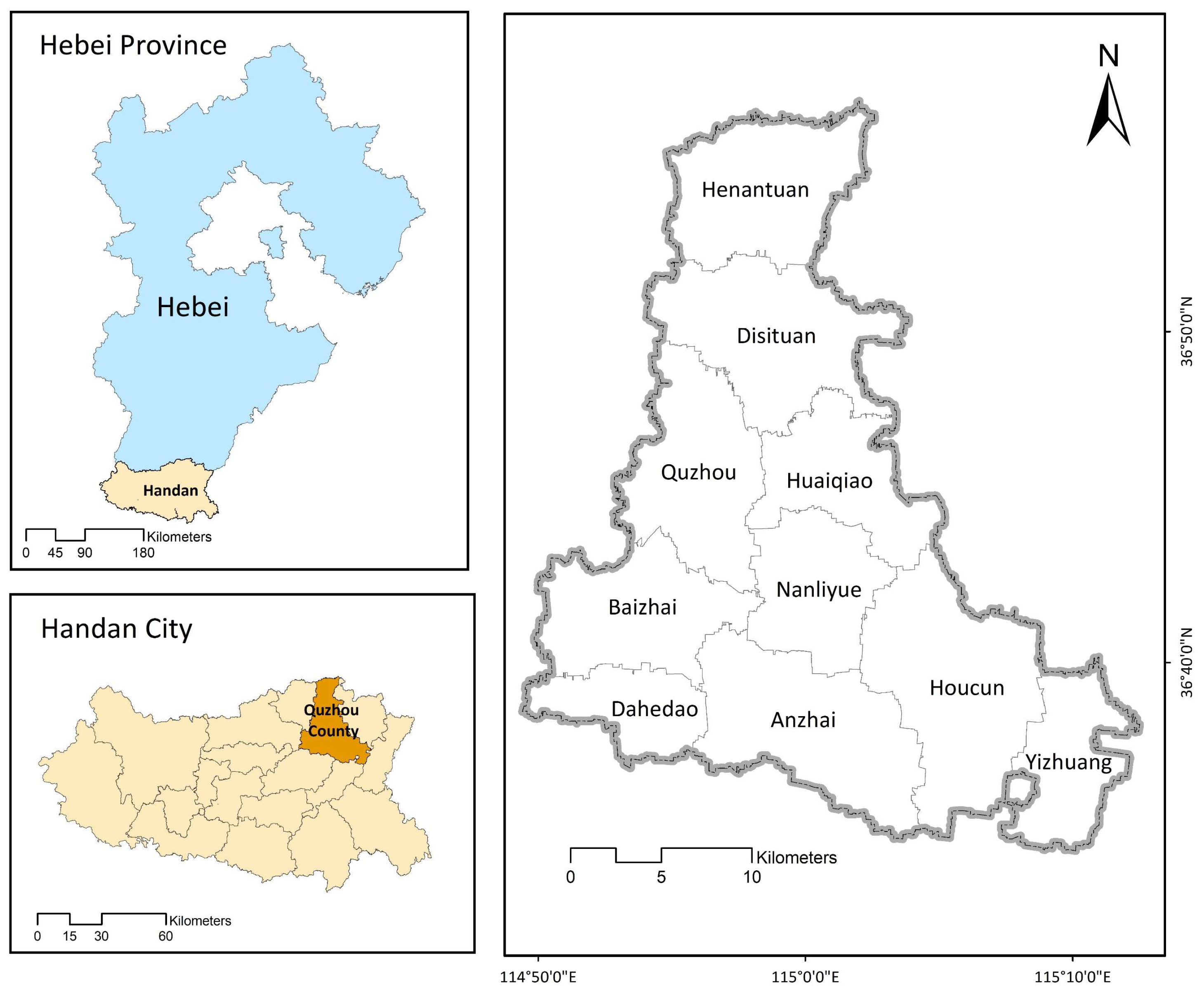
2.1. Study Area

Quzhou County (114°50′30″ E–115°13′30″ E, 36°34′45″ N-36°57′57″ N) is in Handan City, Hebei Province, China (Figure 1). It covers an area of 67,668.09 ha and consists of 10 townships. The county has a warm, temperate, semihumid, continental, monsoon climate, with an average annual average precipitation of 518.5 mm.
Quzhou County is a main grain production region, in which wheat, maize, and cotton are the main crops grown. In 2020, the cultivated land area reached 74.23%, the multiple cropping index was 1.52, and the GDP of the primary industry reached CNY 2465.48 million. In recent years, the sown areas of farm crops in Quzhou County have been relatively stable, remaining at approximately 70,000–80,000 ha. Grain crops have always dominated, accounting for an average of over 70%. In 2020, the output of grain crops reached 402,015 tons. At the same time, the output per unit area also increased to 6996.68 kg/ha in 2020. This growth is closely related to both the increase in output per unit area of various grain crops and the change in the internal planting structure of grain crops. With limited water resources, the sown areas of wheat declined with water fluctuations, whereas the sown areas of corn rose significantly. The output per unit area of corn was higher than that of wheat. Therefore, the output per unit area and total output of grain crops significantly improved. Similarly, the output per unit area and total output of cotton in 2020 also increased significantly.
The composition of water use in Quzhou County has not recently changed substantially. In 2020, the total water use in Quzhou County was 101.35 million m3, comprising 88.15 million m3, 86.98% of the total. For agricultural uses, groundwater accounted for 49.59%. However, with the surface water supply increasing in recent years, agricultural water use from surface water and groundwater sources has changed significantly. The total water use and agricultural use have essentially remained unchanged, but the proportion of groundwater in agricultural water use has clearly decreased. In the future, with the improvement of surface water supply capacity, it is expected that the water supply from groundwater will continue to decline, which will be conducive to the continuous improvement of the ecological environment in Quzhou County.
In addition, to improve crop output, farmers have invested in a large amount of production materials, mainly pesticides and chemical fertilizers. In 2020, the consumption of chemical fertilizers and pesticides in Quzhou County was 45,537 tons and 338 tons, respectively. These levels resulted in increased energy consumption and carbon emissions, affecting the regional ecological environment.
Quzhou County is not only a main grain production region but also a highly representative, intensive agricultural region in China. Cultivated land is the main land use type in Quzhou County, but in recent years, due to social and economic development, urban expansion, and construction occupation, the cultivated land area has decreased significantly. At the same time, due to the serious shortage of surface water during the peak of irrigation usage in the past, groundwater had to be mined for irrigation, leading to prominent groundwater problems. In addition, according to surveys and interviews, in order to improve crop yield, farmers invested a large amount of production materials in agricultural production, resulting in increased energy consumption and carbon emissions, which affected the regional ecological environment quality. Therefore, the question of how to alleviate the contradiction and conflict between crop production and resource constraints in Quzhou County in order to achieve sustainable utilization of cultivated land is an urgent issue. At present, the typical intensive agricultural areas represented by Quzhou County are all facing the same problem.

2.2. Data

The socioeconomic data used in this study mainly originated from the Rural Statistical Yearbooks of Hebei Province (2001–2021), the Statistical Yearbooks of Handan City (2001–2021), and the Statistical Yearbooks of Quzhou County (2000–2020), with information mainly including the total population, rural population, gross domestic produce and its composition, sown areas and output of crops, consumption of chemical fertilizers, electricity, pesticides, etc. The cultivated land area data were collected from and provided by the Department of Natural Resources of Quzhou County. Data regarding agricultural water use and its proportion of the total originated from the Water Resources Bulletins of Quzhou County (2000–2020).

2.3. Methods

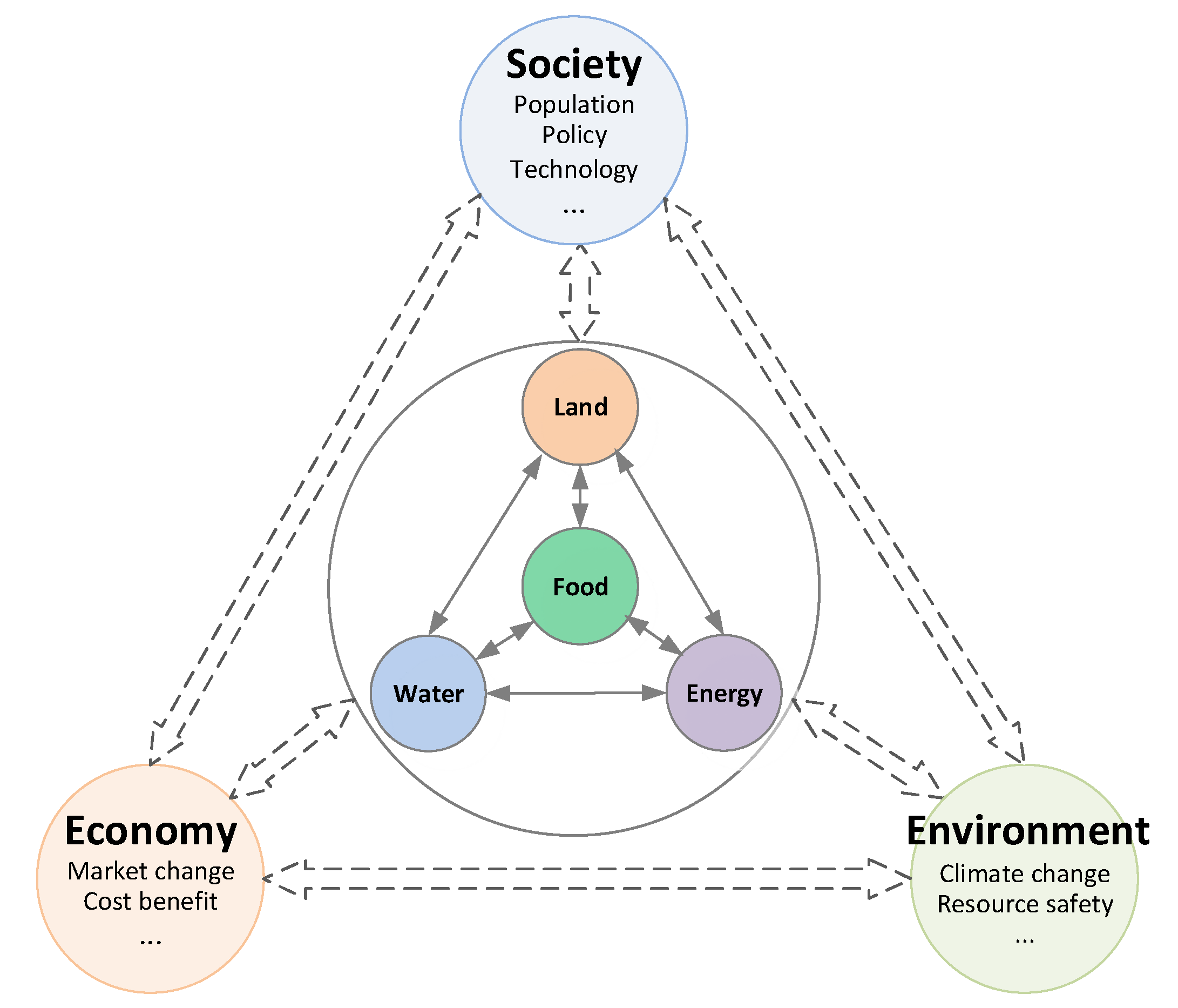
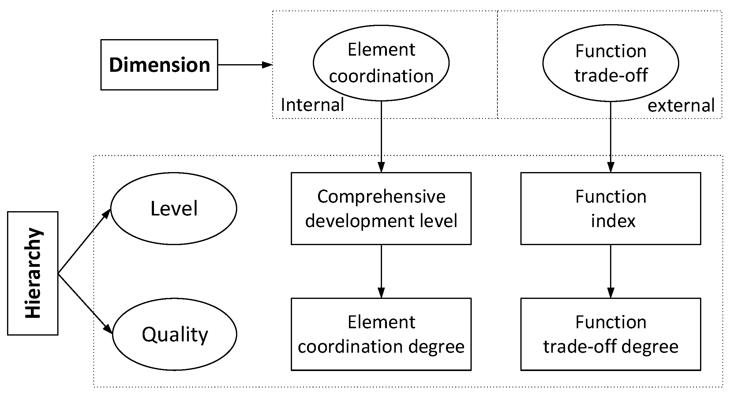
2.3.1. Theoretical Analysis and Evaluation Framework

(1)
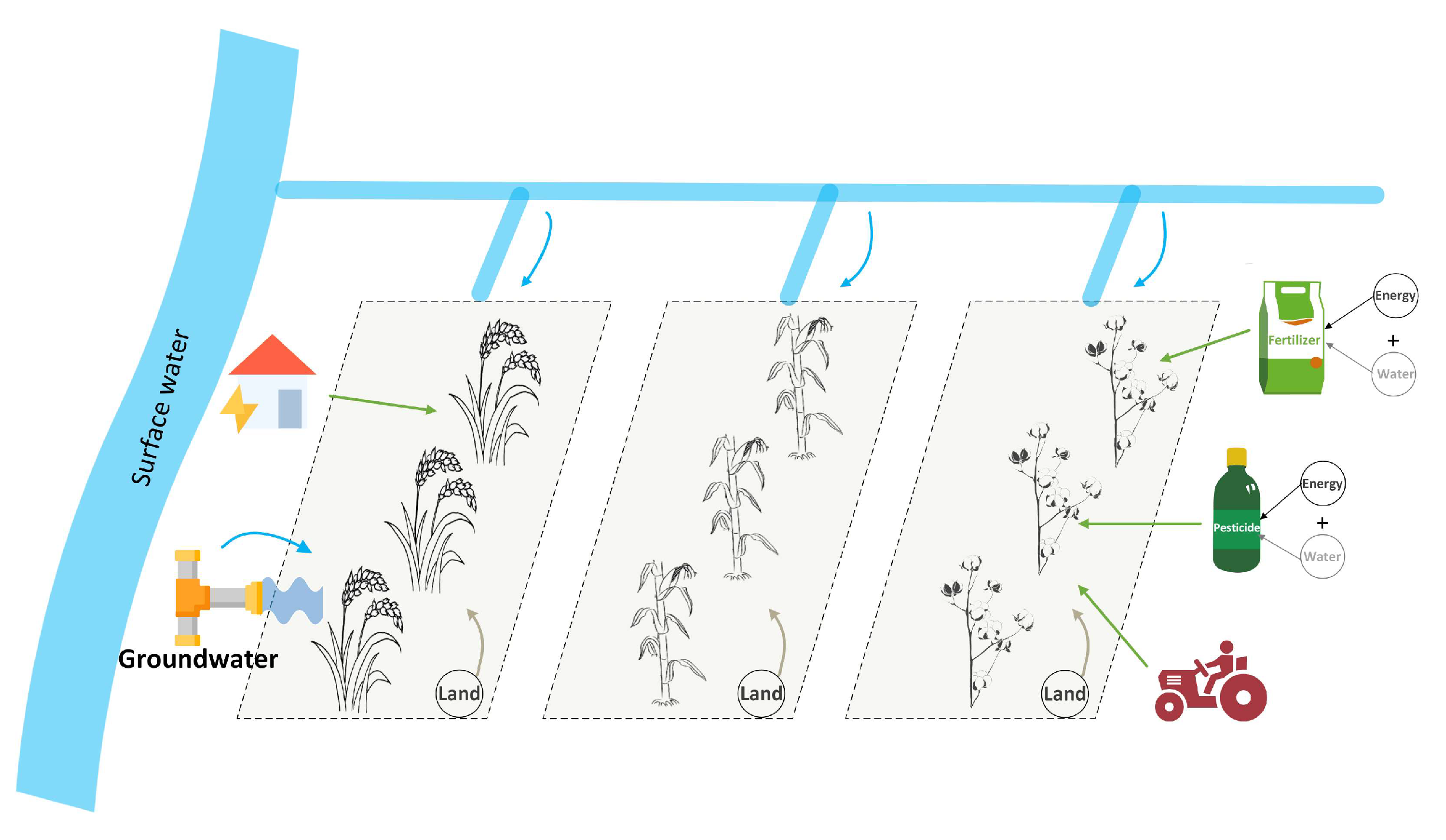
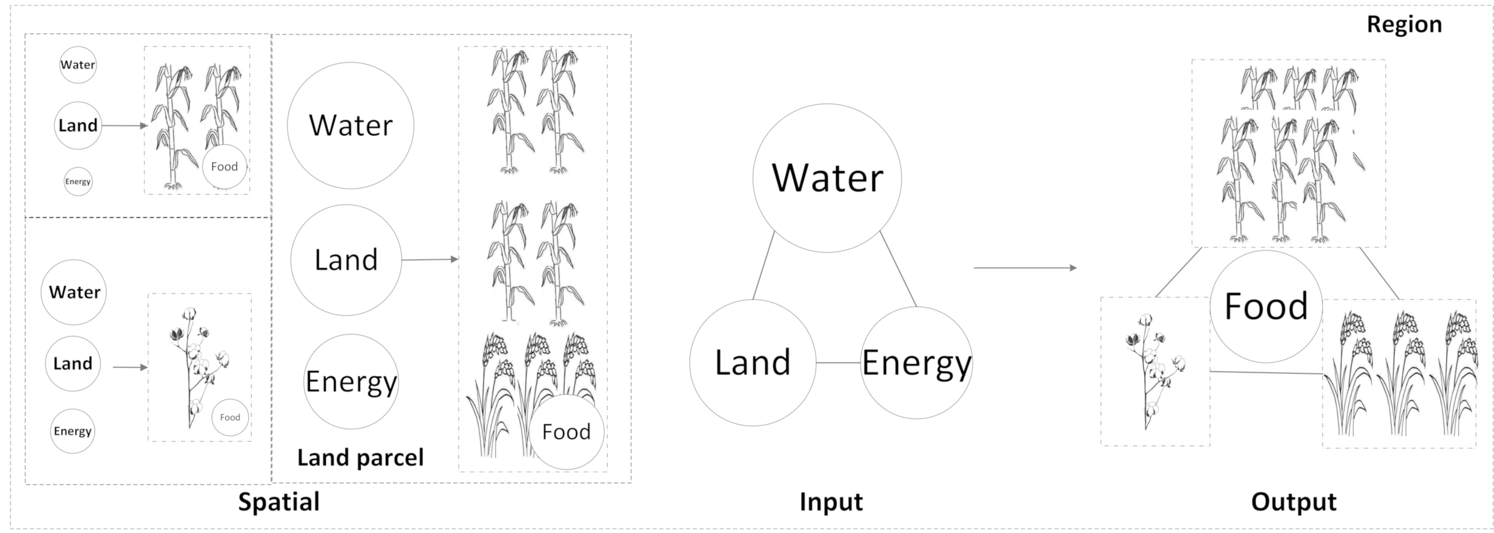
Theoretical Explanation of Cultivated Land Use from the Perspective of the WLEF Nexus
In a broad sense, the WLEF nexus refers to the complex relationships among water, land, energy, and food. These factors affect, interact with, and restrict each other and are influenced by external social, economic, and environmental influences (Figure 2). Based on the analysis of the main factor flow, the development and utilization of water resources need energy input; energy development relies on water, land, and food inputs; food production requires inputs of water, land, and energy inputs; and water and energy are necessary for land resource development and utilization. The WLEF nexus has obvious temporal-spatial distribution characteristics [24] because of the different natural, social, and economic conditions in different regions and at different times, such as climate, hydrology, soil, and scientific and technological levels of agricultural production. Water, land, energy, and food are closely related, and they interact with external social, economic, and ecological environments [36]. Only by identifying the interaction of WLEF nexus elements can we effectively balance resource shortages and high food demand. However, to apply theoretical research to practice, it is necessary to deeply study the interaction between the WLEF nexus and the external environment from a more systematic and comprehensive perspective [37,38].
Typically, cultivated land use, namely, agricultural food production, is a water- and energy-intensive process. For sustainable cultivated land utilization, solutions considering the scope of the nexus rather than individual elements can provide more sustainable sources for decisions due to the very nature of the WLEF nexus. Thus, the WLEF nexus provides a good research perspective for the study of cultivated land use. At the same time, based on the existing concept of cultivated land use and the theory of land use systems, the theoretical explanation should follow the framework of element–structure–function [39], which can provide a scientific reference for evaluating the sustainability of cultivated land use.
  • Element
In the process of cultivated land use, the main components are the inputs of water, land, and energy and the output of food. The flow process of elements is shown in Figure 3. Water input includes direct input as irrigation water and indirect input as water consumed in the production processes of pesticides and fertilizers. According to the industrial water consumption quota in Hubei, Jiangsu, and other major producing provinces, the annual water input in the production of fertilizers and pesticides in the study area is much lower than that of irrigation water, so only irrigation water input is considered in this study. The input of land resources refers to the cultivated land resources used for crop production. There are land competitions among food crops and energy crops. The crops in the study area are principally food crops. Energy input includes diesel, electricity consumed in crop production, and energy used in the production of pesticides and fertilizers. In particular, the “food” in the WLEF nexus not only refers to wheat, corn, and other food crops but also includes cotton, oil, and other cash crops, thus containing all crops produced by cultivated land.
  • Structure
Generally, the structure of the flow process is different if the arrangement of elements is different. It can also reflect the coordination degree of elements. In addition, different elements have different structural characteristics because of their own characteristics. For instance, considering source differences, the structure of water can be divided into surface water and groundwater; the structure of energy can be divided according to the different forms of energy input such as diesel, electricity, pesticides, fertilizers, etc.; and food structure can be distinguished according to different crop types. The structural characteristics of the above three elements are mainly related to quantity and proportion. Specifically, because of their fixed location and diverse functions, land resources also have the characteristics of spatial structure.
In this view, from the perspective of WLEF nexus, the structure of cultivated land use can be subdivided into input, output, and spatial structure. Input structure refers to the quantity structure of water, land, fertilizer, pesticide, diesel, and other energy element inputs. The output structure is the quantity structure of the production of different crops. Spatial structure varies based on the input–output structure at different spatial locations and thus results in different structural complexities at different scales. Specifically, the number of crop types on a cultivated land parcel is usually limited; the structure may include only input and output structures. However, on a regional basis, spatial structure should be considered. Furthermore, the structure at different scales is correlated (Figure 4).
  • Function
The multifunctionality of cultivated land includes fundamental economic, social, and ecological functions and provides a kind of objective concept. In the early period, although the food production capacity was relatively low, there was almost no conflict in the social, economic, and ecological functions due to slow population growth and low demand. Later, with the continuous increase in population, social and economic activities increased significantly, as did crop production. Crop production became dependent on large amounts of inputs such as water, cultivated land, fertilizers, and pesticides, which led to increasing pressure on resources and the environment. Then, conflicts among the social, economic, and ecological functions became increasingly obvious. It is ideal but difficult to simultaneously maximize social, economic, and ecological functions (Figure 5). Therefore, the question of how to balance the three functions should be intensively studied.
(2)
Evaluation Framework
The basis of optimal holistic decision making is a quantitative understanding of the interrelationships in the WLEF nexus related to cultivated land use. Based on the above theoretical explanation that adopts an element–structure–function framework, sustainable cultivated land utilization relies on coordinated elements, reasonable structures, and synergistic functions. This type of land utilization can be simplified to the latter two factors since the overall structure is affected by a combination of elements. Referring to the evaluation methods of system coordination and function synergy, this study built an evaluation framework for the sustainable utilization of cultivated land (Figure 6), in which element coordination and function trade-offs were considered, as were development level and quality.
The element coordination degree is determined by the development level of internal elements. The higher the development level of each element and the higher the degree of element coordination, the more reasonable and sustainable the cultivated land utilization will be. The function trade-off degree is determined by the external function index. The trade-off is a method that is widely used in the analysis of ecosystem services. The trade-off between different ecosystem services refers to the change in one service resulting from the change in another, similar to cultivated land use multifunctionality. The higher the different function indexes and function trade-off degrees are, the higher the function coordination degree, which means that cultivated land utilization will be more reasonable and sustainable.

2.3.2. Element Coordination

(1)
Evaluation Indicators of Element Coordination
In general, a scientific indicator system comprises the principles of scientificity, comprehensiveness, independence, significance, operability, etc. On the basis of the above theoretical analysis, actual conditions in the study area, and data availability, 11 indicators related to water, land, energy, and food were selected as coordination elements for a sustainable utilization evaluation of cultivated land (Table 1).
Water-related indicators include agricultural water use and its proportion, which represent the total amount of water used in the process of cultivated land use and the structure of its use, respectively. Generally, when land, energy input, and food output remain unchanged, the greater the total amount of agricultural water used, the greater the water use per unit of land or crop output, and the lower and more uncoordinated the development level of cultivated land use. Agricultural water proportion refers to the proportion of agricultural water use to total water use. With the continuous advancement of industrialization and urbanization, water demand for nonagricultural industries continues to expand. Usually, the proportion of agricultural water in developed regions is relatively low, only 13.8% in Shanghai and below 30% in Chongqing and Beijing. The higher the proportion of agricultural water is, the lower the development level of cultivated land use.
Land-related indicators mainly represent the development level from intensity and efficiency of use perspectives. Since the staple crops in Quzhou County are cotton and grain such as wheat and corn, sown grain crops and cotton are selected. The larger the sown area of grain crops and cotton and the smaller the cultivated land area are, the higher the intensity and efficiency of cultivated land, which means a higher development level of cultivated land use.
Energy-related indicators represent the main types of energy consumption in the process of cultivated land use, including direct energy consumption (agricultural diesel and electricity) and indirect energy consumption (fertilizers and pesticides). All energy consumption is calculated by the energy consumption coefficient, as shown in Table 2 [40,41]. The greater the energy consumption is, the lower the energy utilization efficiency, which means a lower development level of cultivated land use.
Food-related indicators should reflect the level of agricultural production. Since the staple crops in Quzhou County are cotton and grain such as wheat and corn, total grain output and cotton output are selected. Generally, the higher the output of grain crops or cotton is, the higher the development level of food, which means a higher development level of cultivated land use.
(2)
Evaluation Methods of Element Coordination
Data standardization: Because the dimensions of each evaluation index are not the same, to make the evaluation results comparable, range standardization is used for nondimensional indicators. The calculation formula is as follows:
Positive   indicator :     X i = x i x m i n x m a x x m i n
Negative   indicator :     X i = x m a x x i x m a x x m i n
where X i is the standardized indicator value, x i is the raw indicator value, and x m a x and x m i n are the maximum and minimum raw indicator values, respectively.
Indicator weight determination: The indicator weight represents its relative importance for the evaluated object. The methods mainly include subjective weighting, objective weighting, and combination weighting. The subjective weighting method depends on the experience of decision makers, which is strongly subjective. The objective weighting method mainly relies on the measured data and extracts effective information through certain mathematical operations to obtain the weights. If the measured data are wrong, the final evaluation result will be biased. The combination weighting method can compensate for the shortcomings of a single method.
In this study, the objective weighting method is used since the specific data are objective statistics. The advantages and disadvantages of each objective weighting method are considered, and the combination weighting method is selected; it is composed of entropy and the complex correlation coefficient and uses both different and similar information in complementary ways.
The entropy weight method makes use of different information. As the dispersion degree of an indicator becomes greater, the amount of information provided increases, that is, the corresponding indicator weight becomes greater. The specific calculation method is as follows: Supposing that there are n evaluation objects and m evaluation indicators, construct a matrix X = x i j m × n i = 1 , 2 , 3 , , m ;   j = 1 , 2 , 3 , , n .
f i j = x i j / j = 1 n x i j
H i = k j = 1 n f i j ln f i j
k = 1 / ln n
ω i 1 = 1 H i m i = 1 m H i
where ω i 1 is the entropy weight of evaluation indicator i; H i is the entropy of evaluation indicator i; k is the entropy coefficient; and f i j is the proportion of indicator i in evaluation object j, as f i j = 0 , f i j ln f i j = 0 .
The complex correlation coefficient method obtains the weight according to the correlation of indicators. The stronger the independence of the indicator is, the greater the weight. The calculation formula is as follows:
ω i 2 = 1 / R i i = 1 m 1 / R i
where ω i 2 is the complex correlation coefficient weight of indicator i, and R i is the complex correlation coefficient between indicator i and others.
The combination weighting method includes linear weighting and multiplication. In this study, the latter is selected. The calculation formula is as follows:
W i = ω i 1 ω i 2 i = 1 m ω i 1 ω i 2
where W i is the combination weight of indicator i.
For the weights of different indicators, since their importance cannot be reflected in the above evaluation indicators, a more direct subjective weighting method is adopted. By consulting numerous experts who are familiar with the actual situation in the study area, this study finally determined that water, land, energy, and food are equally important to cultivated land use.
Comprehensive development level evaluation: The comprehensive development level of cultivated land utilization is calculated by the level of all elements, which is calculated by the standardized indicator value. The calculation formula is as follows:
D L ε = i = 1 m W i X i
D L = ε = 1 4 D L ε 4
where D L ε is the comprehensive development level of each element, and D L 1 , D L 2 , D L 3 ,   and   D L 4 are the comprehensive development levels of water, land, energy, and food, respectively. W i is the weight of each evaluation indicator; DL is the comprehensive development level of cultivated land utilization.
To make the results more intuitive, the comprehensive development level is divided into four levels (Table 3).
Element coordination degree evaluation: At present, there are various methods of coordination degree evaluation, such as the development speed consistency coordination degree, the deviation coefficient minimization coordination degree, the Gini coefficient coordination degree, the distance coordination degree, and the comprehensive coordination degree evaluation model, which are closely related. It is essential to evaluate the gap between the actual and ideal states, and the ideal coordination state is assumed to be different in each method. The sustainability of cultivated land use is not a simple sum of various factors because of synergistic actions. Therefore, ignoring any factor will have a significant impact on the sustainable use of cultivated land. The comprehensive coordination degree evaluation method is selected in this study; it is based on the principle of adiabatic elimination and geometric averaging. It is assumed that the comprehensive development level of all elements reflects their coordination degree, and all elements are equally important. The calculation formula is as follows:
C = ε = 1 4 D L ε 1 / 4
where C is the element coordination degree of cultivated land use. Clearly, when the comprehensive development level of any indicator is 0, the cultivated land use is in a state of serious imbalance.
The element coordination degree ranges from 0 to 1. To facilitate the differentiation and evaluation of system coordination states, the system coordination level is divided into 6 levels, as shown in Table 4.

2.3.3. Function Trade-Off

(1)
Evaluation Indicators of Function Trade-Off
Based on the above theoretical analysis of cultivated land use function, the actual conditions in the study area, and the availability of data, a total of 9 indicators related to social, economic, and ecological functions were selected for the function trade-off of the sustainable use evaluation of cultivated land (Table 5).
Social function indicators mainly represent the guarantee of food security, the capacity of carrying rural population employment, and the impacts of these on people’s living standards. Thus, the per capita grain output, labor carrying capacity, and comparative advantage index of grain and cotton output per unit area are selected. The higher the per capita grain output is, the higher the food security for the region, thus reflecting the capacity to absorb the labor force per unit area of cultivated land. The greater the labor carrying capacity is, the greater the cultivated land employment carrying capacity for rural people. The comparative advantage index of crop output per unit area is a comprehensive reflection of the resource endowment, various material input levels, production technology, etc. The greater the comparative advantage index is, the more residents can live and work in peace and contentment. According to the staple crops in the study area, the comparative advantages of grain crops and cotton per unit yield are selected.
Economic function indicators mainly represent the ability to promote regional economic development via agricultural production; thus, the net profit of crop production and the contribution rate of agriculture are selected. Net profit reflects the level of economic output from agricultural production, in which the total cost includes land cost and production cost (input of fertilizers, pesticides, electricity, diesel, and other material costs and labor costs).
Ecological function indicators represent the influence of production factor input on the ecological environment in the process of cultivated land use. The total energy consumption, proportion of agricultural groundwater use, and net carbon sequestration are selected. Total energy consumption represents energy consumption in agricultural production. The proportion of agricultural groundwater use represents the impact on the groundwater environment. Due to the long-term overexploitation of groundwater for agricultural irrigation, the groundwater level in Quzhou County is low: in 2017, it was listed as a shallow groundwater general overexploitation area and a deep groundwater severe overexploitation area. Carbon sequestration is one of the main ecological functions of cultivated land. Photosynthesis of crops absorbs carbon, whereas crop autotrophic respiration, soil nonroot respiration, and various production activities emit carbon. Generally, the lower the total energy consumption is, the lower the proportion of agricultural groundwater use, and the larger the net carbon sequestration is, the better the ecological function of cultivated land use.
(2)
Evaluation Methods of Function Trade-Off
Function index evaluation: The function index is determined by weighted calculation of each standardized function evaluation indicator. The calculation formula is as follows:
F ε = i = 1 m W i X i
where F ε is the function index; W i   and   X i are the weight of the evaluation indicator i of each function and the standardized function evaluation indicator value, respectively, whose calculation formulas are the same as in Section 2.3.2.
Function trade-off evaluation: This study aims to analyze the changes in each function in recent years and their trade-offs. On the basis of the trade-off degree model of ecosystem services and land system functions for short-term dynamic change analysis, the calculation formula is as follows:
T D p q = F p b F p a F q b F q a
where T D p q is the trade-off degree of functions p and q ; F p b   and   F q b are the function indexes of functions p and q in year b , respectively; F p a   and   F q a are the function indexes of functions p and q in year a , respectively; and T D p q represents the degree and direction of the interaction between functions p and q . When positive, the two functions change in the same direction, indicating a cooperative relationship. When negative, the reverse change between the two functions indicates a trade-off relationship. Its absolute value represents the degree of change in function p contrasting with function q .

3. Results

3.1. Changes in the Element Coordination of Cultivated Land Use in Quzhou County

3.1.1. Changes in the Comprehensive Development Level

The comprehensive development level changes in the four elements and cultivated land use in Quzhou County from 2000 to 2020 are shown in Figure 7.
The comprehensive development level of water in Quzhou County was between 0.15 and 0.88 from 2000 to 2020, showing a state of fluctuation. In addition to the impact of agricultural production mode and scale, agricultural water consumption was affected by natural precipitation, water supply from water conservancy projects, and water allocation, which had certain uncertainties. According to changes, the comprehensive development level of water could be roughly divided into three stages: (a) From 2000 to 2005, the comprehensive development level of water was relatively high, which was fair or good. At this stage, agricultural water use was lower, and its proportion was relatively low; the production mode was low input and low output. (b) From 2005 to 2015, the comprehensive development level of water was at a relatively poor level resulting from the continuous and significant increase in grain crop sown area, irrigation water consumption per unit yield, and unit sown area. Compared with the previous stage, this stage represented a high-input and high-output production mode. (c) From 2015 to 2020, the comprehensive development level of water was better than that of the previous period, mainly because Quzhou County gradually completed the comprehensive management project of groundwater overextraction for irrigation, which improved the guarantee rate of irrigation and the utilization efficiency of irrigation water while ensuring stable output. Therefore, although the sown area of crops was still increasing and the yield per unit area was still at a high level, the irrigation water consumption per unit sown area was significantly reduced, and the comprehensive development level of water was significantly improved.
The comprehensive development level of land in Quzhou County was between 0.21 and 0.74 from 2000 to 2020, with two rapid drops followed by steady and then quick recovery, which was mainly influenced by the sown area of various crops, crop market prices, agricultural policies, etc. There were roughly three stages: (a) From 2000 to 2007, the comprehensive development level of land was first significantly reduced, influenced by the decline in wheat sowing area, which rapidly decreased from good to poor and then basically stabilized at a fair level. (b) From 2007 to 2017, the comprehensive development of land was first significantly reduced because of the decreased corn sown area, which dropped from fair to poor until 2009. Although the associated resource subsystem was still poor, the evaluation value increased year by year, and its state improved. (c) From 2017 to 2020, the comprehensive development level of land rebounded rapidly due to the obvious increase in the sown area of corn and cotton, from fair to good.
The comprehensive development level of energy in Quzhou County from 2000 to 2020 was between 0.08 and 0.78, showing a long-term fluctuation and decline and then a rapid increase in the last few years. It could be roughly divided into two stages: (a) From 2000 to 2017, the development level of energy showed a downward trend, from fair to poor. The significant increase in the consumption of electricity for irrigation, fertilizers, and pesticides for higher output contributed to the rapid growth of energy consumption. (b) From 2017 to 2020, the rapid recovery in the comprehensive energy development level benefited from measures to promote reductions in fertilizer and pesticide consumption and to increase efficiency in Quzhou County. The organization and implementation of soil testing, formula fertilization, water and fertilizer integration, and other technologies achieved remarkable results and greatly improved the comprehensive development level of energy.
The comprehensive development level of food in Quzhou County from 2000 to 2020 was between 0.15 and 0.87, showing a slight decline at first, then a gradual rise, and then most recently maintaining a stable and high level. It could be roughly divided into three stages: (a) From 2000 to 2003, the development level of food was poor and slightly decreased year by year, mainly due to the significant decline in wheat sown area and output. (b) From 2003 to 2011, it improved rapidly, from poor to excellent. The primary reasons for this increase included the rapid improvement of grain crop output per unit area and the significant expansion of corn sown area, resulting in a significant increase in the total grain output. (c) From 2011 to 2020, the comprehensive development level of food remained basically stable at a relatively high level. At this stage, the production of wheat and corn was relatively stable, whereas the comprehensive development level of food fluctuated slightly with the changes in the sowing area and output of cotton, which were obviously influenced by market price and cost.
The comprehensive development level of cultivated land use in Quzhou County from 2000 to 2020 was between 0.32 and 0.68, which was poor or fair in most years and was jointly affected by all four elements. Overall, in the early stage, the comprehensive development level of food was low; in the later stage, that of energy and land was low; and the comprehensive development level of water resources fluctuated constantly. However, in recent years, due to developments in various policies, science, and technology, the comprehensive development level of land, energy, and food has shown a positive trend, as has cultivated land use.

3.1.2. Changes in the Element Coordination Degree

The changes in the element coordination degree of cultivated land in Quzhou County from 2000 to 2020 are shown in Figure 8.
The coordination degree of cultivated land use in Quzhou County from 2000 to 2020 was low overall. Although the years of 2011 and 2018 to 2020 showed coordination, the remaining years were uncoordinated to varying degrees, among which 2009, 2014, and 2015 were severely uncoordinated. The changes in the element coordination degree indicated three obvious continuous declines and then a brief rise before the element coordination degree finally stabilized at a high level. The main elements behind the changes were different in each period; accordingly, the changes could be divided into three stages.
(a) From 2000 to 2005, the coordination degree was between 0.34 and 0.46, which was mainly affected by land changes. The comprehensive development level of water and food did not change significantly from 2000 to 2003, but that of land decreased dramatically, resulting in a continuous decline in the element coordination degree of the cultivated land, from slight to moderately uncoordinated. Then, the comprehensive development level of land and food improved slightly, and the element coordination degree recovered for a short time and reached a moderately uncoordinated state.
(b) From 2005 to 2011, the element coordination degree was between 0.29 and 0.51, which was mainly affected by water changes. During this period, both the development level of land and energy showed a change trend of first increasing and then decreasing, whereas that of food continuously increased. The water development level showed a change trend of rapidly decreasing and then rapidly increasing, which was the same as the element coordination degree of cultivated land use. The average element coordination degree in this stage was lower than that in the previous stage, and the fluctuation range was larger.
(c) From 2011 to 2020, the element coordination degree was between 0.27 and 0.67, showing a trend of slow decline at first and then rapid rise and stabilizing at a moderately uncoordinated state. During this period, except for water, the elements showed the same change trend, whereas water resource elements still showed a trend of large fluctuations due to their unique uncertainties.
Notably, after 2018, the comprehensive development levels of land, energy, and food were relatively stable and at a high level, and the element coordination level was greatly constrained by water, whose uncertainty and high volatility should be given attention.

3.2. Changes in the Function Trade-Off of Cultivated Land Use in Quzhou County

3.2.1. Changes in the Function Index

The changes in the index of different cultivated land functions in Quzhou County from 2000 to 2020 are shown in Figure 9.
The social function showed two initial decreases and then increases from 2000 to 2020, which were mainly affected by the changes in per capita grain output and the comparative advantage index of grain output. According to these changes, the social function could be divided into four stages: (a) From 2000 to 2003, the social function index was not high. Under the low-input and low-output production modes during this period, the comparative advantage of crop yield per unit area was not obvious. At the same time, the social function index decreased slightly because of the increasing population and the decreasing grain output, per capita grain output, and agricultural labor force. (b) From 2003 to 2012, the social function showed a fluctuating upward trend. At this stage, the labor carrying capacity decreased, but the total and per unit area crop output rapidly increased, which became the main reason for the changes in social function. In particular, the social function rapidly increased to 0.69 in 2012. (c) From 2012 to 2020, the social function declined with fluctuation, with an average value of 0.54, but it was still higher than the average level of the first two stages. During this period, grain production capacity was stable at a high level, but the population was still increasing, leading to a decline in per capita grain consumption. A slight decline in crop yield per unit area led to a shrinking comparative advantage. However, from 2018 to 2020, the carrying capacity of the labor force rebounded significantly, so that the social function remained stable at a medium level.
The economic function fluctuated frequently, showing a small fluctuation from 2000 to 2010 and a rapid decline from 2010 to 2020. In 2020, the total gross domestic product and the gross domestic product of agriculture in Quzhou County increased by 6.6 times and 3.3 times that in 2000, respectively. This means that the development speed of the agricultural economy was much lower than that of the national economy, and the contribution rate of agricultural development was shrinking. In general, different crop prices and costs are affected by domestic and foreign markets, subsidy policy support, climate change, and other complex reasons, which contributed to the net profit decline from 2000 to 2010. During the whole study period, the net profit was highly consistent with the change trend of the economic function, which was the key influencing factor on the economic function.
The ecological function showed a sign-shaped change from 2000 to 2020, with a rapid decline from 2000 to 2004 and a slow fluctuation from 2004 to 2020. After 2018, it increased to more than 0.6. It was at a relatively high level in the whole study period. The proportion of groundwater in irrigation water first increased and then declined with fluctuation. Irrigation water consumption is closely related to rainfall, crop planting structure, crop yield, irrigation area, etc. In the early period, due to the continuous expansion of irrigation water demand, groundwater consumption for irrigation was increasing, which led to the deterioration of the groundwater environment. To solve this problem, Quzhou County adopted a series of relevant measures, including the construction of an ecological water network, which had multiple functions, such as water storage and irrigation. The water supply of surface water continued to increase, and the proportion of groundwater in irrigation water decreased. The net carbon sequestration was affected by the changes in crop sown area, crop output, and the intensity of various production activities. Early crop output and the intensity of various production activities increased at the same time, but the increase in carbon emissions of various production activities was greater than that in crop carbon sequestration, resulting in a decrease in net carbon sequestration. Later, due to scientific and technological progress, the high-input high-output mode gradually changed to the low-input high-output mode, in which the carbon emissions of production activities decreased significantly, which had a significant positive effect on ecological functions.
A comparison of the different function indexes indicates that the changes in cultivated land use function can be divided into three stages: from 2000 to 2010, the economic function index was higher than that of social function and ecological function; from 2010 to 2017, the economic and social function index fluctuated significantly; and from 2017 to 2020, the ecological function index was higher than that of economic function and social function. This development and change were also consistent with the development stage of agriculture in most regions of China, which moved from addressing food supply deficits to increasing farmers’ incomes and then to optimizing production modes. In the early stage, to achieve a substantial increase in agricultural output and rapid development in the agricultural economy, many pesticides, fertilizers, and mulch were utilized, resulting in the deterioration of the ecological environment. However, there was a gradual realization that this agricultural development mode was not sustainable, and the focus of agriculture should be transformed from high-speed development to high-quality development. Therefore, the mode of agricultural production changed. To reduce the consumption of fertilizer and pesticides and improve their utilization efficiency, various technologies, such as soil testing, formula fertilization, green fertilizer rotation, and water and fertilizer integration, have been continuously developed. Quzhou County has achieved remarkable effects, and its ecological function has gradually improved in recent years.

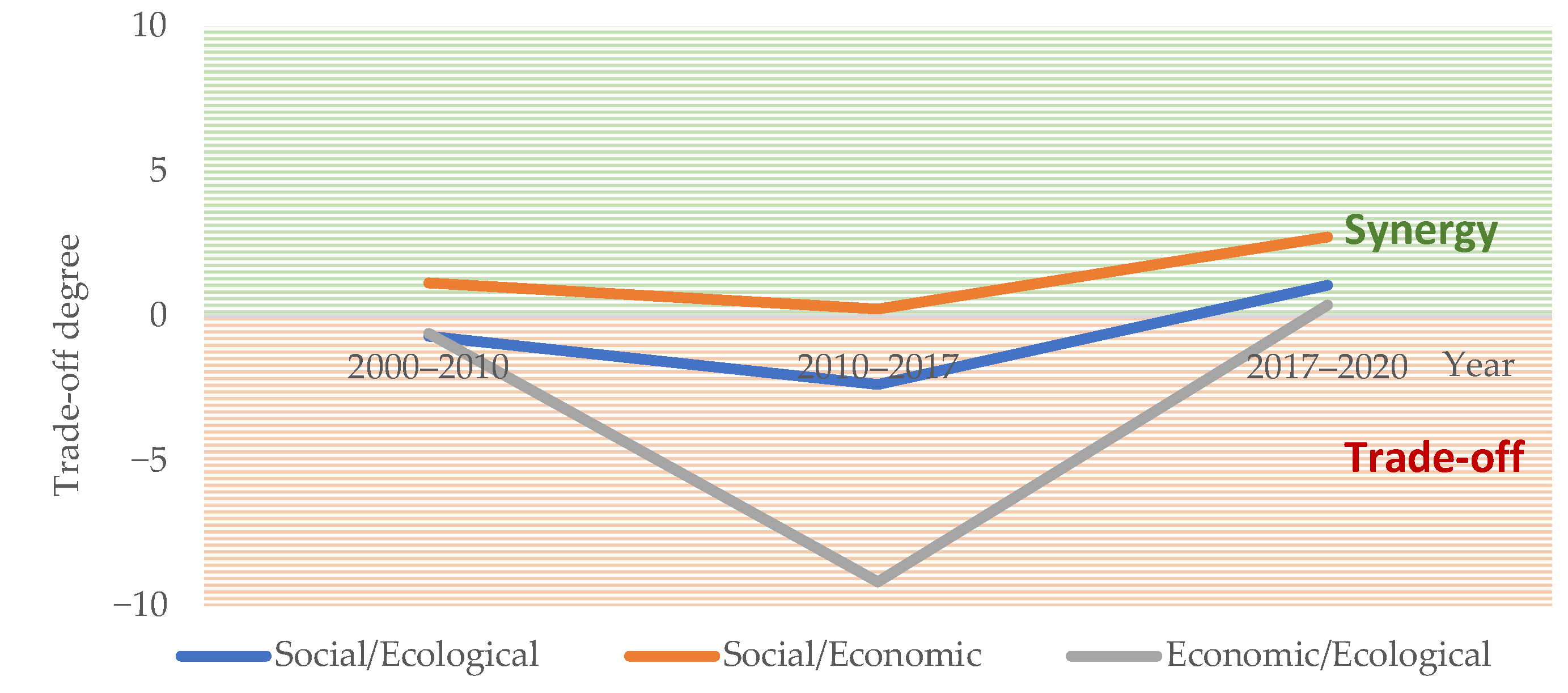
3.2.2. Changes in the Trade-Off Degree

According to the three stages of the changes in cultivated land use, the trade-off degree was calculated, and the results are shown in Figure 10.
The results show that the synergies between the three functions weakened and were then enhanced. Specifically, only the social and economic functions were synergistic all the time, which means that the function index of the two changed in the same direction. The relationships between both the social and ecological functions and the economic and ecological functions showed a change from trade-off to synergy, that is, from restriction to promotion. This was closely related to the change in the cultivated land use mode. From the low-input low-output mode to the high-input high-output mode, the social and economic functions were generally improved, but the negative impact on the ecological environment became increasingly prominent. Therefore, there was synergy between the social and economic functions but a trade-off between the social and ecological functions and the economic and ecological functions. Later, when crop production reached a certain high level, and people realized that the negative impact on the environment could not be ignored, the cultivated land use mode gradually changed to low-input and high-output. At this time, multiple functions changed to the ideal situation of balanced/increasing. As a result, the synergies between the three functions gradually increased. In conclusion, the simultaneous improvement of various functions is the key to the sustainable development of cultivated land use.

4. Discussion

The case study illustrates that the proposed evaluation framework can obtain the sustainable use level of cultivated land. Specifically, the element coordination and function trade-off are regarded as the keys to the sustainable use of cultivated land. The key elements refer to water, land, energy, and food, and the key functions include social, economic, and ecological functions.
Recent developments in the sustainable use evaluation of cultivated land have mainly taken the special situation of different study areas into account, focusing on the construction of an evaluation index system based on the understanding of sustainable use of cultivated land, and they have therefore lacked a unified evaluation framework. For example, Zhong Wen built an evaluation index system for the sustainable use of cultivated land in mountainous areas from the perspectives of ecological friendliness, economic feasibility, and social acceptability [42]. Based on the cognitive framework of “factor-function-value”, Liu Yuepeng constructed an evaluation framework of sustainable use of cultivated land, including quantitative sustainability, productivity sustainability, and ecological sustainability [43]. Xiao Lyu constructed an evaluation index system from the aspects of intensive management, high yield efficiency, non-return of the ecological environment, resource saving, and social sustainability [44]. The sustainable use of cultivated land mainly needs to consider the impact of water, soil, energy, and grain and their interlinkages on the entire cultivated land use. Therefore, Nie Yaling constructed an agricultural land evaluation index system based on the perspective of a FEW nexus, including total grain output, total energy consumption, total water consumption, total profit, and environmental penalty [45]. This was a relatively early study that applied nexus thinking to the evaluation of cultivated land use. However, the evaluation indexes were relatively specific and cannot be applied to all regions. This study laid a certain foundation for this paper to carry out an assessment of cultivated land use based on the nexus perspective. In this paper, nexus thinking is combined with the classical research framework of land use research to build a universal evaluation framework covering most of the existing results. At the same time, compared with the existing studies, considering the relevant factors separately is more conducive to the decision-making support of the corresponding management departments, which is also in line with the significance of the nexus, that is, to overcome the problem of the dissynergy of objectives of different management departments.
It is worth noting that the selection of specific indicators in the evaluation framework directly affects the scientific rationality of the evaluation results. Limited by time and data, this paper is mainly based on the theoretical analysis of cultivated land use from the perspective of the WLEF nexus and evaluates the sustainable use of cultivated land based on element coordination and function trade-offs, thus representing a new avenue of research on indicator systems for the sustainable use of cultivated land. However, the conditions of cultivated land differ among regions. Therefore, when conducting research on the sustainable use of cultivated land in other areas, the main factors influencing the development and function of regional cultivated land use factors should first be clarified, and the indicator system proposed in this paper should be optimized and adjusted. For example, for regions with different types of main crops, the comprehensive development level of food and land factors should be quantified by selecting different areas and outputs of crops sown. For southern areas with abundant water resources and better groundwater environments, the consideration of water should mainly consider surface water. Therefore, exploring a multiregional and differentiated indicator system for the sustainable use of cultivated land is an important direction for future research.
In addition, recent developments in nexus thinking have taken into account the impact of COVID-19 on the nexus in many regions [46,47,48]. This reveals that the impact of such external environmental changes may also have a corresponding impact on the change in the nexus in the process of arable land use. Thus, this will affect the sustainability of cultivated land use, and it is an area that needs more attention. There is also a good study in which Hussam Hussein and Fatine Ezbakhe focus on the operationalization of the WEM nexus in the Mediterranean region, particularly the instruments used (or intended to be used) to bridge the gap between policy discussions and implementation, and they reflect on whether the new WEM nexus is a useful framework or simply a policy buzzword [49]. This seems to question the concept of a WEM nexus, but the study does not completely deny its existence. Undoubtedly, water, employment, and migration have a certain correlation, but they are still affected by human subjective factors, as well as economic and social factors, and the WEM nexus is very hard to evaluate quantitatively. However, in the analysis of the other nexuses, such as the WLEF nexus, the correlation between elements is closer than that of the former. This also shows that in the process of analysis of the former, more factors should be considered, and the relationship is more complex, which may be one of the reasons for the conclusion of the study. In addition, research objects of the nexus are usually multi-factors, many of which may be uncertain and complicated, and the effects between factors are more complex and are more influenced by the external environment. At present, it is still difficult to analyze the nexus qualitatively or even quantitatively, which is also one of the research directions in nexus thinking proposed by many scholars for the future. In most of the current studies, certain simplifications or assumptions have been made. There is still a much research on the nexus that needs to be explored and improved upon continuously, in order to provide support for management decision making based on a systemic, interdisciplinary perspective [50].
Meanwhile, through further analysis of the element coordination and function trade-offs of cultivated land use, it is more beneficial to analyze the obstacles and to put forward countermeasures. According to the research results and the analysis of causes, the comprehensive development level of cultivated land use is affected by the development level of all four elements. In recent years, due to the development of various agricultural production policies, cultivated land protection policies, and scientific and technological levels in Quzhou County, the comprehensive development levels of water, land, energy, and food have shown a positive trend, as has cultivated land use. Notably, however, compared with the other three elements, water, due to its uncertainty and fluctuation and relatively low comprehensive development level, is still the most crucial factor in the unstable and low comprehensive development level and coordination degree of cultivated land use in Quzhou County. In addition, in recent years, the ecological function of cultivated land use in Quzhou County has shown a synergistic relationship with social and economic functions. The ecological function has been continuously improved as the supply of surface water resources has increased; this change is obvious but still weak. This function is closely related to water resource exploitation and utilization in Quzhou County.
For a long time, Quzhou County used many pumping wells to exploit groundwater for irrigation due to an inherent shortage of water resources. This long-term exploitation caused the groundwater level to drop rapidly, and concerns developed regarding the safety of the groundwater environment. In recent years, with the construction of the Handan ecological water network, the completion and implementation of the South-to-North Water Diversion Project, and other projects, the surface water supply of Quzhou County has significantly increased, and water problems have been alleviated. However, at present, Quzhou County still suffers from problems such as uneven spatial distribution or severe siltation of irrigation systems and many unconnected ponds, resulting in low utilization efficiency of surface water resources, insufficient storage, the utilization of external water and stormwater resources, and dependence on groundwater for irrigation in some areas. As a result, the recovery speed of the groundwater level has decreased, and the protection and restoration of the groundwater environment have also been directly affected. The groundwater environment also indirectly affects resource utilization and input–output efficiency in the process of cultivated land utilization; furthermore, low groundwater levels restrict efficient cultivated land use and sustainable development.
In the future, the element coordination and functional synergy of cultivated land use in Quzhou County will continue to rely on water first; this choice is influenced by continuous improvements in the comprehensive development level and stability of water and the groundwater environment via the rational layout of irrigation systems, water-saving irrigation, external water and stormwater resource utilization, as well as the combined utilization of surface water and groundwater. In particular, the optimization of irrigation water systems is conducive to good irrigation conditions, especially for surface water, which can enhance the suitability of crop planting. It also helps improve land use intensity by eliminating current water supply constraints that affect the planting of high-water consumption cash crops and the land multiple cropping index, two factors conducive to improving the carrying capacity of the labor force and increasing economic benefits. Moreover, it is essential to continue promoting efficient and technology-oriented irrigation water, fertilizer, and pesticide use to reduce the fierce contradictions between economic benefit, total yield, irrigation water productivity, ecological environmental protection, and so on, thus effectively promoting sustainable cultivated land use [51,52,53,54].

5. Conclusions

Based on the perspective of the WLEF nexus, this paper has carried out a theoretical analysis of cultivated land use following a factor–structure–function framework, built an assessment framework for the sustainable use of cultivated land, and presented element coordination and function trade-off as the keys to the sustainable use of cultivated land. Then, evaluation indexes were selected from four elements (water, land, energy, and food) and three functions (social, economic, and ecological functions); these indexes informed the evaluation method of the sustainable use of cultivated land based on the nexus.
The evaluation results showed that, affected by the changes in the comprehensive development level of water, land, energy, and food, the coordination degree of cultivated land use in Quzhou County from 2000 to 2020 showed an obvious continuous decline three times, then a brief rise, and it finally stabilized at a high level. In addition, closely related to the development and change in the mode of cultivated land use, the degree of synergy between the social, economic, and ecological functions of cultivated land use initially decreased and then gradually increased; it evolved toward an ideal situation of balanced/increasing. This means that the sustainable use level of cultivated land in Quzhou County basically presents a good trend.
By analyzing the indicators for the sustainable use of cultivated land, this paper has found that the uncertainty and high volatility of water resources have a significant influence on cultivated land use. In Quzhou County, water was the key factor affecting land input and grain output. At the moment, water is the obstacle that is restricting efficient cultivated land use and sustainable development, and this should be improved by some measures in the future. The results of this evaluation have important theoretical and practical significance for identifying the characteristics of cultivated land use change and guiding future sustainable use in Quzhou County and other regions.

Author Contributions

Conceptualization, A.C., Z.H., R.W., H.Z., J.H., R.X. and H.D.; methodology, A.C.; software, A.C.; data curation, A.C.; formal analysis and writing—original draft, A.C.; writing—review and editing, A.C., Z.H, R.W., H.Z., J.H., R.X. and H.D.; supervision, J.H. and H.D.; funding acquisition, H.Z. and H.D. All authors have read and agreed to the published version of the manuscript.

Funding

This research was funded by the National Key Research and Development Program of China (2021YFB3900602).

Data Availability Statement

Publicly available sources of the data used in this study are described in this article; for other data used, please contact the corresponding author on reasonable grounds.

Acknowledgments

The authors appreciate the insightful and constructive comments of the anonymous reviewers. The authors would also like to thank the Department of Natural Resources and Water Resources of Quzhou County for collecting the data.

Conflicts of Interest

The authors declare no conflict of interest.

References

  1. Bruinsma, J. The Resources Outlook: By How Much Do Land, Water and Crop Yields Need to Increase by 2050. In Expert Meeting on How to Feed the World in 2050; FAO: Rome, Italy, 2009. [Google Scholar]
  2. Al-Saidi, M.; Elagib, N.A. Towards understanding the integrative approach of the water, energy and food nexus. Sci. Total Environ. 2017, 574, 1131–1139. [Google Scholar] [CrossRef] [PubMed]
  3. Mohtar, R.H. The WEF Nexus Journey. Front. Sustain. Food Syst. 2022, 6, 820305. [Google Scholar] [CrossRef]
  4. Mohtar, R.H.; Daher, B. Water-Energy-Food Nexus Framework for facilitating multi-stakeholder dialogue. Water Int. 2018, 41, 655–661. [Google Scholar] [CrossRef]
  5. Ringler, C.; Bhaduri, A.; Lawford, R. The nexus across water, energy, land and food (WELF): Potential for improved resource use efficiency? Curr. Opin. Environ. Sust. 2013, 5, 617–624. [Google Scholar] [CrossRef]
  6. Gonzalez-Salazar, M.A.; Venturini, M.; Poganietz, W.; Finkenrath, M.; Kirsten, T.; Acevedo, H.; Spina, P.R. A general modeling framework to evaluate energy, economy, land-use and GHG emissions nexus for bioenergy exploitation. Appl. Energy 2016, 178, 223–249. [Google Scholar] [CrossRef]
  7. Siciliano, G.; Rulli, M.C.; D’ Odorico, P. European large-scale farmland investments and the land-water-energy-food nexus. Adv. Water Resour. 2017, 110, 579–590. [Google Scholar] [CrossRef]
  8. Van den Heuvel, L.; Blicharska, M.; Masia, S.; Sušnik, J.; Teutschbein, C. Ecosystem services in the Swedish water-energy-food-land-climate nexus: Anthropogenic pressures and physical interactions. Ecosyst. Serv. 2020, 44, 101141. [Google Scholar] [CrossRef]
  9. Sang-Hyun, L.; Makoto, T.; Rabi, H.M.; Jin-Yong, C.; Seung-Hwan, Y. An Analysis of the Water-Energy-Food-Land Requirements and CO2 Emissions for Food Security of Rice in Japan. Sustainability 2018, 10, 3354. [Google Scholar]
  10. Venghaus, S.; Märker, C.; Dieken, S.; Siekmann, F. Linking Environmental Policy Integration and the Water-Energy-Land-(Food-)Nexus: A Review of the European Union’s Energy, Water, and Agricultural Policies. Energies 2019, 12, 4446. [Google Scholar] [CrossRef]
  11. Namany, S.; Al-Ansari, T.; Govindan, R. Sustainable energy, water and food nexus systems: A focused review of decision-making tools for efficient resource management and governance. J. Clean. Prod. 2019, 225, 610–626. [Google Scholar] [CrossRef]
  12. Foran, T. Node and regime: Interdisciplinary analysis of water-energy-food nexus in the Mekong Region. Water Altern. 2015, 8, 655–674. [Google Scholar]
  13. Chang, Y.; Li, G.; Yao, Y.; Zhang, L.; Yu, C. Quantifying the water-energy-food nexus: Current status and trends. Energies 2016, 9, 65. [Google Scholar] [CrossRef]
  14. Olsson, G. Water, energy and food interactions-challenges and opportunities. Front. Environ. Sci. Eng. 2013, 7, 787–793. [Google Scholar] [CrossRef]
  15. Khan, S.; Hanjra, M.A. Footprints of water and energy inputs in food production—Global perspectives. Food Policy 2009, 34, 130–140. [Google Scholar] [CrossRef]
  16. Guillaume, J.H.A.; Kummu, M.; Eisner, S.; Varis, O. Transferable principles for managing the Nexus: Lessons from historical global water modelling of Central Asia. Water 2015, 7, 4200–4231. [Google Scholar] [CrossRef]
  17. De Strasser, L.; Lipponen, A.; Howells, M.; Stec, S.; Brethaut, C. A methodology to assess the water energy food ecosystems nexus in Transboundary River Basins. Water 2016, 8, 59. [Google Scholar] [CrossRef]
  18. Kibaroglu, A.; Gursoy, S.I. Water-energy-food nexus in a transboundary context: The Euphrates-Tigris river basin as a case study. Water Int. 2015, 40, 824–838. [Google Scholar] [CrossRef]
  19. Keskinen, M.; Someth, P.; Salmivaara, A.; Kummu, M. Water-energy-food nexus in a transboundary river basin: The case of Tonle Sap Lake, Mekong River Basin. Water 2015, 7, 5416–5436. [Google Scholar] [CrossRef]
  20. Gulati, M.; Jacobs, I.; Jooste, A.; Naidoo, D.; Fakir, S. The water-energy-food security nexus: Challenges and opportunities for food security in South Africa. Aquat. Proc. 2013, 1, 150–164. [Google Scholar] [CrossRef]
  21. Smajgl, A.; Ward, J.; Pluschke, L. The water-food-energy nexus—Realising a new paradigm. J. Hydrol. 2016, 533, 533–540. [Google Scholar] [CrossRef]
  22. Li, Y. Security Evaluation of Water-Energy-Food Nexus System in China Based on Synergetic-Symbiosis Theory. Master’s Thesis, Shandong Agricultural University, Taian, China, 2020. [Google Scholar]
  23. Xiang, Y. Study on Water-Land-Food(WLF) Nexus in Northeast China. Ph.D. Thesis, Chinese Academy of Agricultural Sciences, Beijing, China, 2020. [Google Scholar]
  24. Zhou, L.M.; Xie, X.H.; Zhu, Z.D.; Wang, L.X.; Wu, J.Y. Input-output efficiency of agricultural resources based on the water-energy-food nexus. J. Agric. Resour. Environ. 2020, 37, 875–881. [Google Scholar]
  25. Peng, S.M.; Zheng, X.K.; Wang, Y.; Jiang, G.Q. Study on water-energy-food collaborative optimization for Yellow River basin. Adv. Water Sci. 2017, 28, 681–690. [Google Scholar]
  26. Feng, Y.Z. A study on the Coupled and Coordinated Development of Water-Energy-Food System—A Case Study of Four Provinces in the Huaihe River Basin. Master’s Thesis, Nanjing Forestry University, Nanjing, China, 2020. [Google Scholar]
  27. Zhao, L.S.; Liu, S.J.; Sun, C.Z. Study on coupling and coordinated development of water-energy-food security system in Yellow River Basin. Water Resour. Prot. 2021, 37, 69–78. [Google Scholar]
  28. Bi, B.; Chen, D.; Deng, P.; Zhang, D.; Zhu, L.Y.; Zhang, P. The evolutionary characteristics analysis of coupling and coordination of regional water-energy-food. China Rural Water Hydropower 2018, 72–77. [Google Scholar]
  29. Guo, J. The Abundance and Shortage of Regional Water Resource and Its Impacts on the Coupling and Coordination Degree of Water-Energy-Food Compound System. Master’s Thesis, Northwest A & F University, Yangling, China, 2019. [Google Scholar]
  30. Stucki, V.; Sojamo, S. Nouns and numbers of the water-energy-security nexus in Central Asia. Int. J. Water Resour. Dev. 2012, 28, 399–418. [Google Scholar] [CrossRef]
  31. Halbe, J.; Pahl-Wostl, C.; Lange, M.A.; Velonis, C. Governance of transitions towards sustainable development—The water-energy-food nexus in Cyprus. Water Int. 2015, 40, 877–894. [Google Scholar] [CrossRef]
  32. Sahina, O.; Stewarta, R.A.; Richardsb, R.G. Addressing the water-energy-climate nexus conundrum: A systems approach. In Proceedings of the 7th International Congress on Environment Modelling and Software, San Diego, CA, USA, 15–19 June 2014. [Google Scholar]
  33. Ju, X.W. Research on Sustainable Development of Water, Energy and Food in China Based on System Dynamics. Master’s Thesis, China University of Petroleum, Beijing, China, 2019. [Google Scholar]
  34. Mi, H.; Zhou, W. The system simulation of China’s grain, fresh water and energy demand in the next 30 years. Popul. Econ. 2010, 31, 1–7. [Google Scholar]
  35. Li, G.J.; Li, Y.L.; Jia, X.J.; Du, L.; Huang, D.H. Establishment and simulation study of system dynamic model on sustainable development of water-energy-food nexus in Beijing. Manag. Rev. 2016, 28, 11–26. [Google Scholar]
  36. Li, G.J.; Huang, D.H.; Li, Y.L. Water-energy-food nexus (WEF-Nexus): New perspective on regional sustainable development. J. Cent. Univ. Finance Econ. 2016, 12, 76–90. [Google Scholar]
  37. Bazilian, M.; Rogner, H.; Howells, M.; Hermann, S.; Arent, D.; Gielen, D.; Steduto, P.; Mueller, A.; Komor, P.; Tol, R.S.J.; et al. Considering the energy, water and food nexus: Towards an integrated modelling approach. Energy Policy 2011, 39, 7896–7906. [Google Scholar] [CrossRef]
  38. Allouche, J.; Middleton, C.; Gyawali, D. Nexus Nirvana or Nexus Nullity? A Dynamic Approach to Security and Sustainability in the Water-Energy-Food Nexus. In STEPS Working Paper 63; STEPS Centre: Brighton, UK, 2014. [Google Scholar]
  39. Du, G.M.; Chai, L.J.; Li, Y.H. Theoretical explanation and research framework of cultivated land use system. Prog. Geogr. 2022, 41, 1288–1299. [Google Scholar] [CrossRef]
  40. Xu, J.H. A Study on the Energy Use and Energy Efficiency of Grain Production—Empirical Analyse Based on DEA. Master’s Thesis, Zhejiang University, Hangzhou, China, 2011. [Google Scholar]
  41. Zhang, R. Study on the Relationship between Grain Production and Water and Energy in Ningxia. Master’s Thesis, Xi’an University of Technology, Xi’an, China, 2019. [Google Scholar]
  42. Zhong, W. Evaluation index system and evaluation of sustainable utilization of cultivated land in the southwest frontier mountain area. Chin. J. Agric. Resour. Reg. Plan. 2018, 39, 48–53, 217. [Google Scholar]
  43. Liu, Y.P. Analysis of Spatial and Temporal Variability and Sustainability Assessment of Arable Land System in Shandong Province. Ph.D. Thesis, Shandong Agricultural University, Taian, China, 2022. [Google Scholar]
  44. Lyu, X.; Peng, W.; Niu, S.; Qu, Y.; Xin, Z. Evaluation of sustainable intensification of cultivated land use according to farming households’ livelihood types. Ecol. Indic. 2022, 138, 108848. [Google Scholar] [CrossRef]
  45. Nie, Y.; Avraamidou, S.; Xiao, X.; Pistikopoulos, E.N.; Li, J.; Zeng, Y.; Song, F.; Yu, J.; Zhu, M. A Food-Energy-Water Nexus approach for land use optimization. Sci. Total Environ. 2019, 659, 7–19. [Google Scholar] [CrossRef]
  46. Al-Saidi, M.; Hussein, H. The water-energy-food nexus and COVID-19: Towards a systematization of impacts and responses. Sci. Total Environ. 2021, 779, 146529. [Google Scholar] [CrossRef]
  47. Raya-Tapia, A.Y.; Cansino-Loeza, B.; Sánchez-Zarco, X.G.; Ramírez-Márquez, C.; Ponce-Ortega, J.M. A systematic approach for assessing water, energy and food security during the COVID-19 pandemic: Case study of Mexico. Environ. Dev. Sustain. 2022. [Google Scholar] [CrossRef]
  48. Yin, C.; Pereira, P.; Hua, T.; Liu, Y.; Zhu, J.; Zhao, W. Recover the food-energy-water nexus from COVID-19 under Sustainable Development Goals acceleration actions. Sci. Total Environ. 2022, 817, 153013. [Google Scholar] [CrossRef]
  49. Hussein, H.; Ezbakhe, F. The Water–Employment–Migration nexus: Buzzword or useful framework? Dev. Policy Rev. 2023, 41, e12676. [Google Scholar] [CrossRef]
  50. Hamidov, A.; Daedlow, K.; Webber, H.; Hussein, H.; Abdurahmanov, I.; Dolidudko, A.; Seerat, A.Y.; Solieva, U.; Woldeyohanes, T.; Helming, K. Operationalizing water-energy-food nexus research for sustainable development in social-ecological systems: An interdisciplinary learning case in Central Asia. Ecol. Soc. 2022, 27, 12. [Google Scholar] [CrossRef]
  51. Zhang, F.; Cui, N.; Guo, S.; Yue, Q.; Jiang, S.; Zhu, B.; Yu, X. Irrigation strategy optimization in irrigation districts with seasonal agricultural drought in southwest China: A copula-based stochastic multiobjective approach. Agric. Water Manag. 2023, 282, 108293. [Google Scholar] [CrossRef]
  52. Kelly, T.D.; Foster, T.; Schultz, D.M. Assessing the value of adapting irrigation strategies within the season. Agric. Water Manag. 2023, 275, 107986. [Google Scholar] [CrossRef]
  53. Zhan, X.; Shao, C.; He, R.; Shi, R. Evolution and Efficiency Assessment of Pesticide and Fertiliser Inputs to Cultivated Land in China. Int. J. Environ. Res. Public Health 2021, 18, 3771. [Google Scholar] [CrossRef] [PubMed]
  54. Xie, S.; Feng, H.; Yang, F.; Zhao, Z.; Hu, X.; Wei, C.; Liang, T.; Li, H.; Geng, Y. Does dual reduction in chemical fertilizer and pesticides improve nutrient loss and tea yield and quality? A pilot study in a green tea garden in Shaoxing, Zhejiang Province, China. Environ. Sci. Pollut. Res. 2019, 26, 2464–2476. [Google Scholar] [CrossRef] [PubMed]
Figure 1. Location of Quzhou County in Hebei Province, China.
Agronomy 13 02362 g001
Figure 2. The framework of the water–land–energy–food nexus.
Agronomy 13 02362 g002
Figure 3. Diagram of the element flow process of cultivated land use.
Agronomy 13 02362 g003
Figure 4. Diagram of the structure of the water–land–energy–food nexus system.
Agronomy 13 02362 g004
Figure 5. Diagram of the function of cultivated land use.
Agronomy 13 02362 g005
Figure 6. Evaluation framework of sustainable utilization of cultivated land.
Agronomy 13 02362 g006
Figure 7. Changes in the comprehensive development level of cultivated land use in Quzhou County from 2000 to 2020.
Agronomy 13 02362 g007
Figure 8. Changes in the coordination degree of cultivated land use in Quzhou County from 2000 to 2020.
Agronomy 13 02362 g008
Figure 9. Changes in the functional indexes of cultivated land use in Quzhou County from 2000 to 2020.
Agronomy 13 02362 g009
Figure 10. Changes in the trade-off degree of cultivated land use in Quzhou County.
Agronomy 13 02362 g010
Table 1. Indicator system for the element coordination evaluation of cultivated land use based on the WLEF nexus.
Elemental LayerIndicator SymbolIndicator NameIndicator Type
WaterA1Agricultural water useNegative
A2Proportion of agricultural water useNegative
LandB1Sown area of grain cropsPositive
B2Sown area of cottonPositive
B3Cultivated land areaNegative
EnergyC1Energy consumption of agricultural dieselNegative
C2Energy consumption of electricityNegative
C3Energy consumption of pesticideNegative
C4Energy consumption of fertilizerNegative
FoodD1Total grain outputPositive
D2Cotton outputPositive
Table 2. Energy consumption coefficients. Unit: MJ/kg; MJ/kW·h.
EnergyDieselElectricityPesticideNitrogenous FertilizerPhosphate FertilizerPotash FertilizerCompound Fertilizer
Coefficients43.5412.34100.4824.038.5912.84
Table 3. The evaluation standard of the comprehensive development level.
The Comprehensive Development Level0–0.40.4–0.60.6–0.80.8–1
ConditionPoorFairGoodExcellent
Table 4. The evaluation standard of the system coordination degree.
Coordination Degree0–0.30.3–0.40.4–0.50.5–0.60.6–0.70.7–1
ConditionSeverely uncoordinatedModerately uncoordinatedSlightly uncoordinatedBasically coordinatedModerately coordinatedHighly coordinated
Table 5. Indicator system for the functional trade-off evaluation of cultivated land use based on the WLEF nexus.
Element LayerIndicator SymbolIndicator NameIndicator TypeCalculation FormulaNote
Social functionS1Per capita grain outputPositive S 1 = D 1 P S 1 is the per capita grain output; D 1 is the total grain output; P is the total population.
S2Labor carrying capacityPositive S 2 = P 1 B 3 S 2 is the labor carrying capacity; P 1 is the rural population; B 3 is the cultivated land area.
S3Comparative advantage index of grain output per unit areaPositive S 3 = Y 1 Y G S 3 is the comparative advantage index of grain output per unit area; Y 1 is the grain output per unit area of Quzhou County; Y G is the grain output per unit area of Hebei Province.
S4Comparative advantage index of cotton output per unit areaPositive S 4 = Y 2 Y C S 4 is the comparative advantage index of cotton output per unit area; Y 2 is the cotton output per unit area of Quzhou County; Y C is the cotton output per unit area of Hebei Province.
Economic functionEn1Net profit of crop productionPositive E n 1 = E P E C E n 1 is the net profit of crop production; E P is the output value of crop production; E C is the cost of crop production.
En2Contribution rate of agriculturePositive E n 2 = P a T P E n 2 is the proportion of contribution rate of agriculture; P a is the gross domestic product of agriculture; T P is the total gross domestic product.
Ecological functionEl1Total energy consumptionNegative E l 1 = C 1 + C 2 + C 3 + C 4 E l 1   is the total energy consumption; C 1 is the energy consumption of agricultural diesel; C 2 is the energy consumption of electricity; C 3 is the energy consumption of pesticide; C 4 is the energy consumption of fertilizer.
El2Proportion of agricultural groundwater useNegative E l 2 = A U A 1 E l 2 is the proportion of agricultural groundwater use; A U   is the groundwater use for agriculture; A 1 is the agricultural water use.
El3Net carbon sequestrationPositive N C = C A C L   C A = i = 1 n C A i × Y i × 1 W i × 1 + R i / H i   C L = C L S + C L P = B 3 × c L S + i = 1 m N i × c L P i NC is the net carbon sequestration; C A is the carbon sequestration; C L is the carbon emission; C A i is the carbon content of crop i; Y i is the economic yield of crop i; W i is the moisture content of crop i; H i is the economic coefficient of crop i; R i is the root–shoot ratio of crop i; n is the types of the staple crops; n = 3; C L S is the carbon emission of soil respiration; C L P is the carbon emission of producing activities, including irrigation electricity, diesel, pesticide, and fertilizer; B 3 is the cultivated land area; c L S is the annual soil carbon emission per unit area; N i is the consumption of irrigation electricity, diesel, pesticide, and fertilizer; c L P i is the carbon emission coefficient of each producing activity; m is the types of producing activities, m = 4.
Disclaimer/Publisher’s Note: The statements, opinions and data contained in all publications are solely those of the individual author(s) and contributor(s) and not of MDPI and/or the editor(s). MDPI and/or the editor(s) disclaim responsibility for any injury to people or property resulting from any ideas, methods, instructions or products referred to in the content.

