Article

Non-Synergistic Changes in Migration Processes between Soil Salt and Water in the Salt Patch of the Coastal Saline Soil

1
College of Water Resources & Civil Engineering, China Agricultural University, Beijing 100083, China
2
CAS Engineering Laboratory for Yellow River Delta Modern Agriculture, Institute of Geographic Sciences and Natural Resources Research, Chinese Academy of Sciences, Beijing 100101, China
3
Shandong Dongying Institute of Geographic Sciences, Dongying 257000, China
4
Yellow River Estuary Land-Sea Interaction Field Research Station, Yantai Coastal Geological Survey, Yantai 264000, China
*
Authors to whom correspondence should be addressed.
These authors contributed equally to this work.
Agronomy 2023, 13(9), 2403; https://doi.org/10.3390/agronomy13092403
Submission received: 27 July 2023 / Revised: 5 September 2023 / Accepted: 12 September 2023 / Published: 18 September 2023
(This article belongs to the Section Water Use and Irrigation)

Abstract

:
Salt patches (SPs) with surface salt accumulation pose a serious threat to agriculture in coastal saline lands. However, the migration and distribution of soil water and salt in SPs remain unclear due to complex water–salt transport dynamics. In this study, we focused on typical SPs in the Yellow River Delta region and selected center site (Site 1), transition site (Site 2), edge site (Site 3), and outer site (Site 4) with varying levels of salinization. Field sampling and the HYDRUS-1D model were employed to investigate the migration process and distribution of soil water and salt in SPs, as well as the influencing factors. The results indicated significantly higher salt contents in the central sites (Site 1 and Site 2) compared to the edge sites (Site 3 and Site 4), while no significant differences were observed in soil water content. The bottom soil exhibited greater stability in terms of water and salt content compared to the surface soil. Additionally, soil water content increased with soil depth, whereas salt content decreased from Site 1 to Site 3. Interestingly, Site 4 exhibited the opposite salt distribution pattern in the whole soil depth. We observed that SPs displayed a salt aggregation structure radiating from the center to the periphery, gradually weakening in intensity. Our correlation analysis indicated that the formation of SPs may be influenced by soil particle size distribution, precipitation, and evaporation. Specifically, fine soil structure can impede the upward transport of highly mineralized groundwater, while precipitation and evaporation directly affect the leaching and upward movement of surface soil salt, resulting in uneven salt distribution in the field and the formation of SPs. These findings provide valuable theoretical and technical insights for the prevention and improvement of saline farmlands in the Yellow River Delta.

1. Introduction

Soil salinization is a significant global issue, with saline soils covering approximately 1.1 × 10⁹ hm2, accounting for 10% of the world’s arable land area [1]. In China, the total area of saline soil is approximately 3.69 × 10⁷ hm2, which represents about 5% of the available land [2]. With the growing population, addressing the scarcity of arable land resources and land salinization has become an urgent matter [3,4]. The Yellow River Delta (YRD) is rich in land resources and serves as an important reserve area, but excessive exploitation has led to significant salinization in this region [5]. Consequently, soil salinization is recognized as one of the primary factors limiting agricultural production, food security, and sustainable economic development in the YRD. A comprehensive understanding of the formation mechanism and patterns of water and salt transport in saline soils is crucial for the prevention and improvement of soil salinity [6,7]. This knowledge provides valuable guidance for the appropriate cultivation of crops and the precise implementation of agronomic measures [8]. Therefore, it is imperative to thoroughly investigate the water–salt transport mechanism of saline soils in the YRD to facilitate the development and utilization of these lands.
Defining the dynamics of water and salt transport is essential for studying the evolution and control measures of saline soil. In recent years, the theory of solute transport has been extensively applied to certain special soil conditions in areas such as the YRD, where external factors are particularly complex [9,10]. However, the dynamic patterns of water and salt transport vary in different regions due to multiple factors, including regional variations, topography, climate, soil physicochemical properties, microorganisms, and irrigation and cultivation practices, etc. [11]. Various factors contribute to soil salinization in different regions. In water-scarce areas relying on groundwater for irrigation, such as coastal areas invaded by seawater, groundwater salinity is the primary factor influencing regional soil salinization [12]. In the Inner Mongolia Loop Irrigation Area, where cultivation is frequent, groundwater mineralization is closely related to the frequency of autumn irrigation [13]. Shallow groundwater depth, under the same mineralization conditions, directly induces soil salinization [14]. In arid and semi-arid areas, soil salt is closely related to irrigation management. In agricultural areas with shallow groundwater levels, such as the San Joaquin Valley in California, climate change can increase the level of soil salt in the root zone [15]. For example, in the Yellow River irrigation area, the widespread use of river water for irrigation has led to an increase in groundwater levels and strong soil water evaporation, resulting in soil salinization in one-third of the area [16]. In the agricultural areas of northern Xinjiang, characterized by a dry and cold climate, long-term film-mulching drip irrigation and winter freezing–thawing processes play a significant role in soil salinization by promoting upward migration and concentration of salts, leading to salt accumulation in the soil [17]. In the YRD, where secondary soil salinization is worsening year by year, the shallow groundwater depth, high mineralization, and high soil clay content contribute to the widespread distribution of surface salt accumulation patches (SPs), posing a serious threat to local agricultural production. Therefore, further research is needed to understand the complex water–salt transport system in this region.
Most research on the YRD has focused on the factors influencing soil salinization, water and salt distribution patterns, and soil salt features at a large regional scale. Spatial interpolation techniques have been utilized to estimate the spatial distribution of soil salt in the YRD, revealing groundwater depth, groundwater mineralization, and vegetation cover as the main factors affecting salinity [18,19,20]. Qualitative and quantitative analyses were conducted to employ the grey correlation degree method to investigate the main influencing factors of soil salinization in the YRD [21], which include the degree of groundwater mineralization, vegetation coverage, groundwater depth, and soil particle content in decreasing order of importance. However, research at the field scale, especially concerning the heterogeneity of soil properties in heavily salinized land with and the microscale salt migration, is still limited and requires further in-depth study.
Therefore, this study aims to investigate the distribution and migration patterns of water and salt in salt patches (SPs), areas of dramatic changes in soil water and salt in the YRD, and predict trends in soil water–salt dynamics. Soil samples were collected from a typical area with salt spots near the YRD, and soil water content and salt concentration were analyzed from July 2021 to June 2022 to characterize water–salt transport characteristics. The HYDRUS -1D model was employed to simulate the soil water–salt transport process based on these findings. The results will provide a theoretical foundation for the effective development of saline lands in the YRD and the implementation of rational irrigation systems.

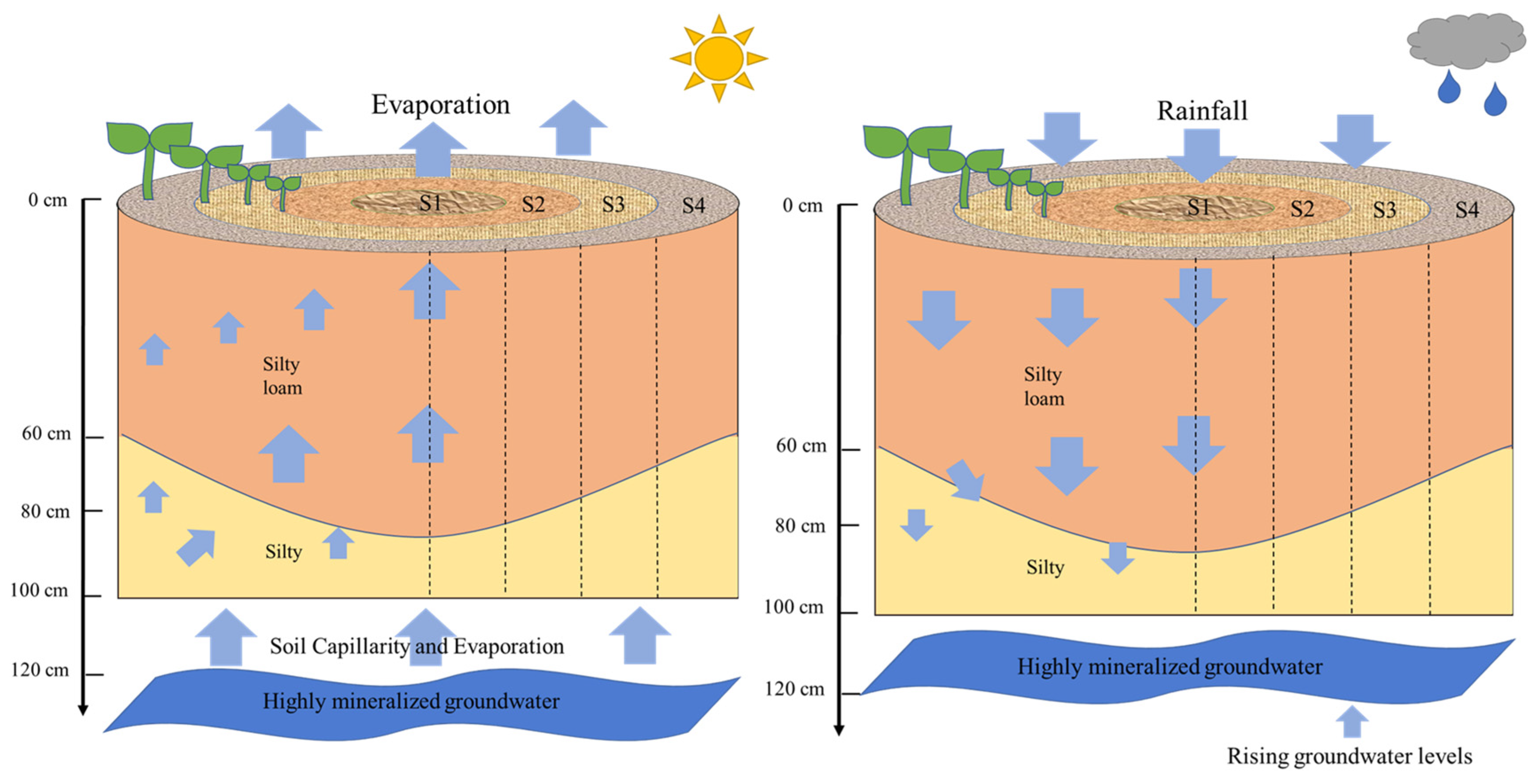
2. Materials and Methods

2.1. Experimental Site

This study was conducted at the YRD Research Centre, Chinese Academy of Sciences, located in Dongying City, Shandong Province (37°40′ N, 118°55′ E). The area experiences a warm temperate monsoon climate with an annual mean temperature of 12.6 °C [22]. The highest monthly temperature is 27.1 °C in July and the lowest is −4.1 °C in January. The annual mean wind speed is 3.2 m s−1. Precipitation is unevenly distributed throughout the year, with an average annual rainfall of approximately 556.1 mm, with 75% occurring between June and September. Evapotranspiration ranges from 1900 to 2400 mm annually, and the ratio of evapotranspiration to precipitation is approximately 3.37. Groundwater levels in this area range from 1.1 m to 2.3 m, with an average salinity of 27.55 g L−1. The predominant soil type is silty loam. The main crops cultivated in the farmland include sorghum (Sorghum bicolor), soybean (Glycine max), and corn (Zea mays). The natural vegetation is primarily composed of reeds (Phragmites australis) and tamarisk (Tamarix chinensis Lour). The high salinity of groundwater in the studied area results in the migration of salt to the soil surface through evaporation and capillary action, leading to widespread soil salinization that significantly impacts local agricultural production. The sorghum, as the single−season crops, were sown during 5−15 June without irrigation during the growth periods in the experimental site. The application amounts of fertilizers were 200 kg N hm2 and 50 kg P2O5 hm2.

2.2. Research Methodology

2.2.1. Sampling Arrangement

In the studied area, a representative SP measuring 20 m × 20 m was selected. The SP was divided into four regions based on the degree of salinization, starting from the center and moving towards the periphery. These regions were designated as the center site (Site 1), transition site (Site 2), edge site (Site 3), and outer site (Site 4). Each site was further divided into three 1 m × 1 m plots for sampling purposes (Figure 1). To establish fixed monitoring points, representative soil sampling points, reflecting the degree of salt accumulation on the surface and the vegetation cover, were selected within each plot. Stratified periodic sampling was conducted at different soil depths, with three plots set up in each region as replicates. Soil samples were collected using a 2.5 cm diameter soil auger, and samples were taken from five layers of soil depths: 0–20 cm, 20–40 cm, 40–60 cm, 60–80 cm, and 80–100 cm. Approximately 200 g of each sample was collected, sealed in sterile plastic self-sealing bags, and transported back to the laboratory for further processing. In the laboratory, soil water content, salinity, pH, and particle size were measured for each soil sample. Sampling took place on various dates: 28 July, 8 August, 16 August, 2 October, and 19 November 2021, as well as on 25 April, 2 June, and 25 June 2022. Meteorological data for the duration of this study were obtained from the meteorological station of the research center (Figure 2).

2.2.2. Sample Processing

After each soil sampling, a fresh soil sample of 20 g was taken, and the soil water content was determined using an oven-drying method. The remaining soil sample was air-dried, ground, and sieved through a 2 mm mesh to prepare an extract (soil/water, 1:5). The pH of the extract was determined using PHS-3E pH meter (Leici Instruments, Shanghai, China), and the soil electrical conductivity (EC) was measured using a conductivity meter (FE38-Standar, Mettler Toledo, Greifensee, Switzerland). To calculate the soil salt content, the equation describing the relationship between EC and salinity content was created using the mass conductivity method (R2 = 0.992; unpublished data). The total soil salt content was determined using the drying method and the EC was measured using a conductivity meter (FE38-Standar, Mettler Toledo, Greifensee, Switzerland). The formula used to convert EC to total soil salt content is expressed as follows:
S t = E C 1 : 5   ×   3.8777     0.1046
where St is the soil salt content (g kg−1); EC1:5 is the soil EC (dS m−1).
The capillary properties of soils exhibit variations due to different soil textures, thereby influencing the capillary rise height, velocity of soil water, and infiltration capacity. These factors directly impact the rate of groundwater evaporation and the dynamic characteristics of water and salt. Soil particle size of the first sample obtained was determined using a particle size analyzer (Mastersizer 2000, Malvern Instruments, Maivem, UK) and classified based on the USDA classification criteria into three categories: clay (<0.002 mm), silt (0.002–0.05 mm), and sand (0.05–2.00 mm). The soil particle size distribution is presented in Table 1.

2.3. HYDRUS-1D Model

The Hydrus model is a numerical model developed by the US Salinity Laboratory based on the SWMS model for simulating water and solute transport in saturated and unsaturated porous media. It is widely used for simulating soil water and salt transport [23].

2.3.1. Basic Equations

In accordance with Darcy’s law and the law of conservation of mass, the vertical movement of soil water in the model is described using Richard’s equation, assuming that the soil is isotropic and homogeneous. The equation is coupled with appropriate initial and boundary conditions to simulate one-dimensional water movement. To solve the equation numerically, the finite difference method is applied. The fundamental equation governing water movement in this model is expressed as follows:
θ t = z K ( h ) h z 1
where θ is the volumetric soil water content (cm3 cm−3); K ( h ) is the unsaturated hydraulic conductivity (cm d−1); h z is the hydraulic potential head gradient; and t is time (min).
Using the water movement equation as the basis and soil-soluble salts as the subject of study, the soil solute transport equation is established:
θ c t = t θ D c z   - qc
where c is the solute concentration (g kg−1). D is the hydrodynamic dispersion coefficient (cm2 d−1). q is the soil water flux coefficient (cm d−1). The equation for the characteristic soil hydrodynamic parameters, i.e., the van Genuchten–Mualem model, is based on a mathematical model to quantify the soil water movement parameters, which is expressed as follows:
Θ h = θ r + θ s - θ r ( 1 + | α h | n ) m ,   h < 0 ; θ s ,   h 0 .  
K ( h ) = K s ,   h < 0 ; K s 1 α | h | n - 1 1 + ( α | h | ) n - m } 2 ( 1 + α | h | n ) m / 2 ,   h 0 .
where θr is the residual volumetric water content of the soil (cm3 cm−3). θs is the saturated volumetric water content of the soil (cm3 cm−3). Ks is the saturated hydraulic conductivity of the soil (cm d−1). α is the inverse of the inlet suction. n is the soil pore volume size distribution index. m is the empirical fit parameter value of m = 1 − n−1.

2.3.2. Model Setting

The tested model was applied to simulate the process of soil water and salt in each region separately. The soil in the depth range of 0–100 cm was used as the simulation profile and was divided into 5 layers containing 5 lithologies, which were discretized into 100 grids at 1 cm equal intervals; the simulation period lasted from 28 July 2021 to 25 June 2022, a total of 333 days, and the time profile method was used for variable time steps. The initial time step was set to 0.001 d, the minimum step to 0.001 d, and the maximum step to 5 d. The accuracy of the soil water content iteration was 0.001 cm3 cm−3, and the accuracy of the pressure head iteration was 1 cm. The time step was adjusted according to the number of convergence iterations, i.e., the convergence of the iterations was handled with automatic control of the time step, with a minimum time step multiplication factor of 1.3 and a maximum time step multiplication factor of 0.7. The upper boundary of the model is an open atmospheric boundary, which is recharged by precipitation; therefore, the actual amount of precipitation is assigned to the upper boundary, and the lower boundary is taken to be the saturated head boundary because of the shallow depth of groundwater in the research site.

2.3.3. Parameter Rate Setting

The soil water characteristics curve of the HYDRUS model, based on the formulation proposed by Van Genuchten (1980) [24], was fitted using the soil particle size composition data for each soil layer presented in Table 1. This fitting process allowed us to determine the values of the soil hydraulic parameters, which are summarized in Table 2.

2.4. Statistical Analysis

The HYDRUS-1D model was employed to simulate the patterns of soil water and salt transport in the experimental area using observed soil water and salt data. The simulated values at different depths were compared with the measured values obtained in 2022 using t-tests. To compare the soil salt and water content among different sites within each soil layer and across different time periods, analysis of variance (ANOVA) based on the Waller–Duncan test was conducted to identify significant differences between groups. Furthermore, Pearson’s analysis was utilized to assess the correlations between the simulated soil salt content and the precipitation and evapotranspiration. Statistical significance was determined when p < 0.05 using SPSS 26.0 software (IBM, Armonk, NY, USA).

3. Results

3.1. Soil Water Dynamic Distribution in SPs

Figure 3 and Table 3 displays the average soil water content in the 0–100 cm soil layer across different regions within the SP during various periods. Throughout the entire study period, from July 2021 to June 2022, the mean soil water contents, in different locations of SPs, for Site 1, Site 2, Site 3, and Site 4 were determined to be 29.20%, 29.35%, 26.72%, and 29.63%, respectively. The corresponding standard deviations of samples during the entire periods were 3.11%, 3.09%, 3.76%, and 2.71%, respectively. Site 4 exhibited the highest soil water content and the lowest variability, while Site 3 had the lowest soil water content and the highest variability. However, there were no significant differences in the overall soil water content among Site 1 through Site 4 throughout the year (p > 0.05; Table 4). When considering each soil layer within the 0–100 cm depth, the mean soil water content values were as follows: 22.59%, 23.33%, 27.62%, 32.48%, and 37.60%. The corresponding standard deviations of each soil layer were 4.45%, 3.13%, 2.45%, 2.56%, and 3.25%, respectively. The distribution of soil water content in each site exhibited an increasing trend with increasing soil depth. The highest spatial–temporal variability in mean soil water content was observed in the layer of 0–20 cm soil depth, followed by the 80–100 cm soil depth. In the 0–60 cm soil depth, no significant differences were found in soil water content among the different sites (p > 0.05; Table 3). However, in the 60–100 cm soil depth, Site 3 exhibited a significantly lower soil water content compared to Site 1, Site 2, and Site 4 (p < 0.05; Table 3).

3.2. Soil Salt Dynamic Distribution in SPs

Figure 4 illustrates the average soil salt content in the 0–100 cm soil layer across different areas of the salt-affected soil during various periods. From July 2021 to June 2022, the mean soil salt contents of the five depths of the entire period in Site 1, Site 2, Site 3, and Site 4, respectively, were measured at 12.74‰, 14.10‰, 3.54‰, and 2.40‰. The corresponding standard deviations of the entire period were 5.01‰, 5.05‰, 1.30‰, and 0.90‰, respectively. The mean soil salt content in Site 1 and Site 2 was significantly higher than that in Site 3 and Site 4 (p < 0.05). Considering the different soil layers, the overall mean soil salt contents in the 0–100 cm soil depth of the four sites were found to be 13.01‰, 8.14‰, 6.45‰, 6.31‰, and 7.07‰, respectively. The corresponding standard deviations of the different layers were 6.76‰, 2.50‰, 2.20‰, 1.83‰, and 2.03‰, respectively. With increasing soil depth, the soil salt content initially decreased and then increased. The distribution of salt content varied among different regions in the vertical direction. Both Site 1 and Site 2 exhibited the phenomenon of salt accumulation in the surface layer (0–20 cm), with the highest and most variable salt content. As the soil depth increased, the soil salt content and variability decreased, with a slight increase observed in salinity and variability in the layer of 80–100 cm soil depth. The mean soil salt content in each soil layer of Site 3 and Site 4 was below 5‰, significantly lower than that of Site 1 and Site 2 (p < 0.05). Site 4 differed from the other sites, displaying the highest and most variable soil salt content in the 80–100 cm soil layer. The soil salt content and its variability increased with increasing soil depth from 20 to 100 cm (Figure 5).
Regarding the temporal scale, the significance levels of soil salt content varied among different sampling intervals (Table 4). In the first sampling, Site 1 and Site 2 exhibited significantly higher soil salt content compared to Site 4 (p < 0.05). In the second sampling, Site 2 had significantly higher soil salt content than other sites (p < 0.05). In the third sampling, Site 1 had significantly higher soil salt content than Site 3 and Site 4 (p < 0.05), while Site 2 had significantly higher soil salt content than Site 4 (p < 0.05). From the fourth to the eighth sampling, the soil salt content in Site 1 and Site 2 was significantly higher than that in Site 3 and Site 4 (p < 0.05), while no significant difference was observed between Site 3 and Site 4 (p > 0.05; Table 4).

3.3. Simulation of Water–Salt Dynamics

Using long-term fixed-point field experimental data and rainfall data, the HYDRUS-1D model was employed to separately simulate each site within the SP (Figure 5). The continuous simulation outputs provided a comprehensive understanding of the water–salt dynamics of saline soil throughout the year. The soil particle size distribution varied among the sites within the SP, resulting in differences in soil hydraulic parameters and reflecting distinct water–salt transport patterns. The results showed no significant difference between the simulated and measured values (p > 0.05; Table 5), indicating that the model effectively captured the dynamic distribution of water and salt in accordance with the observed values.
Overall, the soil water content and salt content in the bottom soil of the SP were found to be more stable compared to the surface soil (Figure 5). There was no significant difference in soil water content among the soil profiles of different regions (p > 0.05), with a general trend of increasing water content with soil depth and a decrease in variability. In the central region of the SP, which exhibited a higher degree of salinization, noticeable salt accumulation phenomena were observed in the surface soil layer (0–20 cm). Following heavy rainfall events, the soil salt content showed a varying degree of decrease. As the rainfall diminished after the summer period, the soil salt content at each site tended to stabilize, gradually decreasing with increasing soil depth. In Site 1 and Site 2, the soil salt content decreased with increasing soil depth, with the 0–20 cm soil layer showing high salt content and significant variation influenced by rainfall. Conversely, the salt content in the 80–100 cm soil layer remained relatively stable at around 10‰ with minimal variation. The differences in soil salt content between each layer of Site 3 and Site 4 were relatively small. Overall, the soil salt content across the SP was below 10‰, and the temporal variation in soil salt content remained within 5‰. Notably, Site 4 exhibited a distinct soil salt distribution pattern compared to other areas, with the highest soil salt content and the greatest variability observed in the bottom soil layer.

3.4. The Impact of Soil Particle Size on Salinity Levels

The physical and chemical properties of the soil in each region of the SP within the 0–100 cm soil layer are summarized in Table 1. As the soil depth increases, the proportion of sand particles initially increased and then decreased, while the proportion of silt and clay particles decreased and then increased. This indicated a gradual change in soil texture from silty loam to silty. In Site 1, Site 2, and Site 3, the soil texture distribution was consistent, with silty loam in the 0–80 cm layer and silty in the 80–100 cm layer. In contrast, the bottom soil layer (80–100 cm depth) of S4 exhibited a finer particle size distribution compared to the other regions. It had a lower proportion of coarser sand particles, accounting for approximately 10% less, and a higher proportion of smaller clay particles, accounting for approximately 5% more (Table 1). In Site 4, the soil texture was silty loam in the 0–60 cm layer and silty in the 60–100 cm layer.
By comparing and analyzing the ratio of sand to clay content in the soil with the soil salt content, a significant positive correlation was observed with a Pearson’s correlation coefficient of 0.595 (Figure 4; p < 0.01). This indicated that a decrease in clay content and/or an increase in sand content may contribute to the exacerbation of soil salinization.

3.5. The Impact of Climate on Salinity Levels

Synthesizing the monthly average meteorological parameters of the research center from July 2021 to June 2022 (Figure 6a), correlation analyses were conducted to examine the relationships between simulated salt content and precipitation, as well as evapotranspiration at different soil depths in Site 1–Site 4 (Figure 6b). The results revealed a significant negative correlation between surface (0–20 cm) soil salt content and precipitation in all sites within the SP (p < 0.05). In Site 1 and Site 2, both the 0–20 cm and 20–40 cm soil depths showed a significant negative correlation between soil salt content and precipitation (p < 0.05). In Site 3, a significant positive correlation was observed between soil salt content at depths of 20–100 cm and precipitation (p < 0.05).
The correlation between soil salt content and evaporation varied among the different sites of the SP. In Site 1 and Site 2, a significant positive correlation was observed between soil salt content at depths of 0–80 cm and evaporation (p < 0.01). In Site 3, a significant negative correlation was found between soil salt content at a depth of 0–60 cm and evaporation (p < 0.01). In Site 4, a significant negative correlation was observed between soil salt content at a depth of 0–100 cm and evaporation (p < 0.05).

4. Discussion

The results showed that the distribution patterns of soil water in the SP exhibited similarities in various regions, while the soil salt distribution differed (Figure 3 and Figure 4). The distribution patterns are as follows: Soil water increases with soil depth, with the highest variability observed in the surface soil layer (Table 3). Salt content varies among different regions within the SP, gradually decreasing from the central site towards the outer sites. Except for the peripheral region, soil salt content generally decreased with increasing soil depth, while in the peripheral site, soil salt content increases with soil depth (Figure 3 and Figure 4). The lower soil water content, higher variability, and higher soil salt content in the surface soil layer of the SP can be attributed to the soil texture in the research site [25]. The soil texture in the SP is silty loam and silty (Table 1). The bulk density increases along with the increase in soil depth in this study. This change can result in denser soil with reducing pore space; therefore, decreasing water channels, and slowing water transport rates [26]. Additionally, the surface soil undergoes elevated evaporation rates attributed to solar radiation and high temperatures [27]; thus, leading to swifter water movement within the upper loamy soil as opposed to the lower sandy loam soil [28]. The shallow groundwater depth (1.1–2.3 m) and high mineralization (27.55 g L−1) in the studied area facilitates the upward migration of salts through soil capillarity and evaporation, eventually accumulating in the surface soil. Consequently, this leads to higher salt content and greater variability in the surface soil layer, while the lower layers exhibit lower salt content and less variability.
In the horizontal direction, the SP exhibits a central accumulation pattern, gradually diminishing towards the periphery (Figure 4). This distribution pattern may be related to the local geographic environment because the YRD has been subjected to multiple flooding and erosion events, resulting in a complex profile with variations in sand, silt, and clay layers [29]. The different configurations of soil texture, including the arrangement of sand and clay particles, determine the physical properties of soil capillary and non-capillary pores, directly influencing the movement of water and salt in the soil [30]. The increased clay content and/or decreased sand content in the peripheral and outer regions of the SP may hinder the upward movement of water, thereby reducing the degree of soil salinization in the upper layers. This differs from the other coastal areas, such as the Jiangsu coastal region, where clay layers promote salt accumulation [31]. In that case, the clay layers at shallow depths impede rainwater infiltration, causing heavy rainfall capable of leaching salt to be mostly lost through surface runoff, resulting in salt accumulation in the surface soil. In contrast, in this study, silty layers are mainly distributed at deeper depths. Comparing the particle size distribution of the outer and central sites of the SP (Table 1), the bottom soil layer of the peripheral site (Site 4) has smaller sized particles, with a sand to clay ratio of only 0.2. The dense sandy loam layer hinders the direct evaporation and upwelling of highly mineralized groundwater, which tends to laterally migrate and accumulate in the central site with a higher sand to clay ratio [32]. These different water and salt processes caused by this discrepancy may be the reason for the different salt distribution in Site 4. Along with soil evaporation and lateral transport of water, salt in the soil redistributes horizontally and vertically with water, resulting in uneven distribution of soil salt in localized areas and promoting the formation of the central region with higher salt content. This study reveals the differences in water and salt distribution patterns among different sites of SPs, providing an important theoretical basis for understanding the formation of SPs.
Based on field sampling, the HYDRUS-1D model was further utilized to comprehensively understand the dynamic changes of soil water and salt (Table 5). Based on the results, both the measured and simulated water contents in the SP showed almost no significant change (Figure 5). The salt content in the central and transitional sites of the SP exhibited pronounced seasonal variations: frequent changes in summer, stability in autumn and winter, and salt accumulation in spring. The peripheral and outer sites of the SP consistently maintained lower soil salt content, with no apparent seasonal pattern (Figure 5). The main reason for the intense seasonal variations in salt content in the central and transitional sites of the SP may be attributed to the uneven seasonal distribution of precipitation in the research site, characterized by distinct rainy and dry seasons (Figure 6a). Precipitation and evaporation directly influence the leaching and upward movement of salts in the soil. As the soil depth increases, the leaching effect of rainfall on soil salt content gradually weakens (Figure 6b). Summer rainfall is concentrated with high intensity and a low evaporation/precipitation ratio, favoring soil desalination [23]. In the surface layer of soils in Site 1 and Site 2, the salt content experiences a decrease and reaches its lowest concentration as a result of leaching during the summer rainfall (Figure 5). In autumn, the soil salt content does not show significant changes, which differs from previous research results in the YRD [33]. This discrepancy may be attributed to the rise in groundwater level due to intense rainfall. However, the lower evaporation/precipitation ratio during autumn is not conducive to salt accumulation in the soil, leading to insignificant variations in salt content during autumn. In winter, as temperatures decrease, the soil enters the freeze–thaw stage, causing soil water to freeze and salt content to remain relatively stable. However, in the late stage of the freeze–thaw stage, the salt content gradually increases in severely salinized areas (Site 1 and Site 2) of the SP, while there is little increase in the less salinized areas (Site 3 and Site 4) (Figure 5). This finding is consistent with previous research, such as studies conducted in Xinjiang, China, which found that the freeze–thaw process affects salt accumulation, and the accumulation of salt is positively correlated with the initial salt content [34]. In spring, with rapidly rising temperature, less precipitation, and strong evaporation, the evaporation/precipitation ratio reaches its peak throughout the year, which corresponds to the period of salt accumulation. As mentioned earlier (Figure 6), soil structure and temperature both affect the transport of water and salt. The water and thermal conditions of the surface soil are more influenced by factors such as rainfall, atmospheric temperature, and evaporation compared to the sub-surface soil, resulting in a lag in salt content changes between the sub-surface and surface layers (Figure 6b). In comparison to the central site, the outer region of the SP exhibits no significant seasonal fluctuations in soil salt content, which remains below 10‰ throughout the year (Figure 5). From Site 1 to Site 3, a conspicuous lack of vegetation distribution is observed; conversely, Site 4 displays a sparse dispersion of vegetation. This may be due to the influence of vegetation growth (such as halophytes and weeds) in addition to climate factors, which alter the water and thermal conditions of the soil from its natural state.
In this study, we propose that the differences of subsoil texture and meteorological factors may contribute to the formation of SPs in the coastal saline region of the YRD (Figure 7). That is, the high mineralization of shallow groundwater provides the fundamental conditions for the formation of SPs, and soil texture variations and vegetation cover influence the intensity of evaporation, causing the movement of groundwater towards sites with higher evaporation rates. Additionally, the seasonal variation in the evaporation/precipitation ratio provides the driving force for the redistribution of salt within SPs, eventually leading to their formation (Figure 7). Although we have speculated on the formation mechanisms of SPs based on multiple results, further evidence is needed to support our findings. For example, it remains to be investigated whether microtopographical differences also influence the formation of SPs. Based on the aforementioned patterns, physical interventions can be implemented to improve SPs. For instance, incorporating dense barrier materials, e.g., peat below the plow layer, can alter the soils’ physical structure; increase the proportion of clay particles in the lower soil layers; enhance soil infiltration and leaching capacity; and inhibit the upward movement of salt, thereby reducing salt accumulation in the surface layer [35,36]. Furthermore, precise control of salt can also be achieved through hydraulic measures. By simulating the leaching effect of rainfall on surface soil salt content (Figure 6b), drip irrigation systems can be strategically installed in the central regions of SPs to wash out and desalinate the surface soil, thereby ensuring a suitable growth environment for crops [37]. However, it is crucial to consider the impact of hydraulic measures on local groundwater levels. In areas with shallow groundwater and high mineralization, excessive irrigation-induced leaching may exacerbate soil salinization [38]. Nevertheless, the findings of this study provide a theoretical basis for the prevention and improvement of saline–alkali land in the YRD.

5. Conclusions

The distribution of soil water in SPs was found to be similar among different sites, while the distribution of salt content varied. This gradual decrease in salt distribution from the center to the periphery and from the surface to the subsurface is likely influenced by the variation in soil particle size distribution. The uneven distribution of soil particle sizes affects the movement of water in the soil, which in turn influences the transport of salts. In the studied area, the high-mineralized groundwater tends to move towards areas with higher evaporation potential due to capillary action. This movement of groundwater, combined with the leaching effect of rainfall, leads to uneven redistribution of salts during transport. As a result, salt accumulation occurs in the surface soil, leading to the formation of the salt patch. The prevention and improvement of salt patches require further investigation and exploration. The findings of this study provide valuable theoretical and technical support for the reclamation and utilization of saline–alkali land in the YRD.

Author Contributions

Writing—review and editing, X.F., Z.L. and K.F.; validation, J.L. (Jing Li), J.L. (Jianbin Lai) and H.G.; methodology, X.F., H.G. and W.D.; data curation, X.F. and Z.L.; conceptualization, Z.S. and Z.O.; project administration, Z.L. and K.F. All authors have read and agreed to the published version of the manuscript.

Funding

This work was supported by the National Agricultural Major Science and Technology Project (No. NK2022180401-1); the Strategic Priority Research Program of Chinese Academy of Sciences (No. XDA26050202); and the National Key Research and Development Program of China (2021YFD190090503).

Data Availability Statement

The data presented in this study are available on request from the corresponding author. The data are not publicly available due to privacy restrictions.

Conflicts of Interest

The authors declare no conflict of interest.

References

  1. Wicke, B.; Smeets, E.; Dornburg, V.; Vashev, B.; Gaiser, T.; Turkenburg, W.; Faaij, A. The global technical and economic potential of bioenergy from salt-affected soils. Energ. Environ. Sci. 2022, 4, 2669–2681. [Google Scholar] [CrossRef]
  2. Ren, L.T.; Wei, T.Y.; Xie, G.H. Evaluation of energy input and output of sweet sorghum grown as a bioenergy crop on coastal saline-alkali land. Energy 2012, 47, 166–173. [Google Scholar] [CrossRef]
  3. Zhang, M.; Dong, B.; Qiao, Y.; Yang, H.; Wang, Y.; Liu, M. Effects of sub-soil plastic film mulch on soil water and salt content and water utilization by winter wheat under different soil salinities. Field Crop Res. 2018, 225, 130–140. [Google Scholar] [CrossRef]
  4. Singh, K. Microbial and enzyme activities of saline and sodic soils. Land Degrad. Dev. 2015, 27, 706–718. [Google Scholar] [CrossRef]
  5. Zhu, W.; Yang, J.; Yao, R.; Wang, X.; Xie, W.; Li, P. Nitrate leaching and NH3 volatilization during soil reclamation in the Yellow River Delta, China. Environ. Pollut. 2021, 286, 117330. [Google Scholar] [CrossRef] [PubMed]
  6. Liu, G.; Wang, C.Z.; Wang, X.H.; Huo, Z.; Liu, J. Growing season water and salt migration between abandoned lands and adjacent croplands in arid and semi-arid irrigation areas in shallow water table environments. Agric. Water Manag. 2022, 274, 107968. [Google Scholar] [CrossRef]
  7. Wen, J.S.; Juan, W.; Xiao, Y.S. Characteristics of Water and Salt Transport in Layered Soils. Adv. Mater. Res. 2012, 518, 5008–5011. [Google Scholar] [CrossRef]
  8. Scudiero, E.; Skaggs, T.H.; Corwin, D.L. Simplifying field-scale assessment of spatiotemporal changes of soil salt. Sci. Total Environ. 2017, 587–588, 273–281. [Google Scholar] [CrossRef]
  9. Heng, T.; Liao, R.; Wang, Z.; Wu, W.; Li, W.; Zhang, J. Effects of combined drip irrigation and sub-surface pipe drainage on water and salt transport of saline-alkali soil in Xinjiang, China. J. Arid Land 2018, 10, 932–945. [Google Scholar] [CrossRef]
  10. Zhu, W.; Yang, J.; Yao, R.; Xie, W.; Wang, X.; Liu, Y. Soil water-salt control and yield improvement under the effect of compound control in saline soil of the Yellow River Delta, China. Agric. Water Manag. 2022, 263, 107455. [Google Scholar] [CrossRef]
  11. Mohanavelu, A.; Naganna, S.R.; Al-Ansari, N. Irrigation induced salinity and sodicity hazards on soil and groundwater: An overview of its causes, impacts and mitigation strategies. Agriculture 2021, 11, 983. [Google Scholar] [CrossRef]
  12. Katz, D. Basin management under conditions of scarcity: The transformation of the Jordan River basin from regional water supplier to regional water importer. Water 2022, 14, 1605. [Google Scholar] [CrossRef]
  13. Liu, Y.; Wang, P.; Gojenko, B.; Yu, J.; Wei, L.; Luo, D.; Xiao, T. A review of water pollution arising from agriculture and mining activities in Central Asia: Facts, causes and effects. Environ. Pollut. 2021, 291, 118209. [Google Scholar] [CrossRef] [PubMed]
  14. Ma, J.H.; Yang, S.Q.; Shi, H.B.; Ding, X.; Han, W.; Du, L. Field scale spatiotemporal distribution and correlation analysis of water-salt in salinization irrigation district. J. Northwest A&F Univ. 2015, 43, 165–173. Available online: https://www.cabdirect.org/cabdirect/abstract/20153351025 (accessed on 30 June 2015). (In Chinses).
  15. Kondash, A.J.; Redmon, J.H.; Lambertini, E.; Feinstein, L.; Weinthal, E.; Cabrales, L.; Vengosh, A. The impact of using low-saline oilfield produced water for irrigation on water and soil quality in California. Sci. Total Environ. 2020, 733, 139392. [Google Scholar] [CrossRef]
  16. Nachshon, U. Cropland soil salinization and associated hydrology: Trends, processes and examples. Water 2018, 10, 1030. [Google Scholar] [CrossRef]
  17. Zhang, X.; Shu, C.; Wu, Y.; Ye, P.; Du, D. Advances of coupled water-heat-salt theory and test techniques for soils in cold and arid regions: A review. Geoderma 2023, 432, 116378. [Google Scholar] [CrossRef]
  18. Zong, R.; Han, Y.; Tan, M.; Zou, R.; Wang, Z. Migration characteristics of soil salinity in saline-sodic cotton field with different reclamation time in non-irrigation season. Agric. Water Manag. 2022, 263, 107440. [Google Scholar] [CrossRef]
  19. Yang, J.; Yao, R. Spatial Variability of Soil Water and Salt Characteristics in the Yellow River Delta. Sci. Geogr. Sin. 2007, 27, 348–353. (In Chinses) [Google Scholar] [CrossRef]
  20. Yao, R.; Yang, J.; Liu, G.; Zou, P. Spatial variability of soil salt in characteristic field of the Yellow River Delta. Trans. CSAE 2006, 22, 61–66. (In Chinses) [Google Scholar]
  21. Wang, Z.; Zhao, G.; Gao, M.; Jiang, S.; Chang, C.; Jia, J. Characteristis of Soil Water and Salt Spatial Variations in the Spring Season in Typical Yellow River Delta Areas of Kenli County, China. J. Agric. Resour. Environ. 2015, 32, 154–161. (In Chinses) [Google Scholar] [CrossRef]
  22. Han, G.; Sun, B.; Chu, X.; Xing, Q.; Song, W.; Xia, J. Precipitation events reduce soil respiration in a coastal wetland based on four year continuous field measurements. Agric. For. Meteorol. 2018, 256, 292–303. [Google Scholar] [CrossRef]
  23. He, K.; Yang, Y.; Yang, Y.; Chen, S.; Hu, Q.; Liu, X.; Gao, F. HYDRUS simulation of sustainable brackish water irrigation in a winter wheat-summer maize rotation system in the North China Plain. Water 2017, 9, 536. [Google Scholar] [CrossRef]
  24. Van Genuchten, M.T. A closed-form equation for predicting the hydraulic conductivity of unsaturated soils. Soil Sci. Soc. Am. J. 1980, 44, 892–898. [Google Scholar] [CrossRef]
  25. Zhao, X.; Xu, H.; Zhang, P.; Fu, J.; Bai, Y. Soil water, salt, and groundwater characteristics in shelterbelts with no irrigation for several years in an extremely arid area. Environ. Monit. Assess. 2013, 185, 10091–10100. [Google Scholar] [CrossRef]
  26. Wu, P.; Wu, X.; Wang, Y.; Xu, H.; Owens, G. Towards sustainable saline agriculture: Interfacial solar evaporation for simultaneous seawater desalination and saline soil remediation. Water Res. 2022, 212, 118099. [Google Scholar] [CrossRef]
  27. Lin, B. The role of agroforestry in reducing water loss through soil evaporation and crop transpiration in coffee agroecosystems. Agric. For. Meteorol. 2010, 150, 510–518. [Google Scholar] [CrossRef]
  28. Mosquera, G.M.; Crespo, P.; Breuer, L.; Feyen, J.; Windhorst, D. Water transport and tracer mixing in volcanic ash soils at a tropical hillslope: A wet layered sloping sponge. Hydrol. Process 2020, 34, 2032–2047. [Google Scholar] [CrossRef]
  29. Zhang, S.; Zhang, Y.; Xu, J.; Guo, L.; Li, G.; Jia, Y.; Qian, L.; Wu, J.; Wen, M.; Zhu, C. In situ observations of hydro-sediment dynamics on the abandoned Diaokou lobe of the Yellow River Delta: Erosion mechanism and rate. Estuar. Coast. Shelf Sci. 2022, 277, 108065. [Google Scholar] [CrossRef]
  30. Wei, Y.; Wu, X.; Cai, C. Splash erosion of clay–sand mixtures and its relationship with soil physical properties: The effects of particle size distribution on soil structure. Catena 2015, 135, 254–262. [Google Scholar] [CrossRef]
  31. Xie, X.; Pu, L.; Zhu, M.; Xu, Y.; Wang, X. Linkage between soil salinization indicators and physicochemical properties in a long-term intensive agricultural coastal reclamation area, Eastern China. J. Soil Sediments 2019, 19, 3699–3707. [Google Scholar] [CrossRef]
  32. Dearman, T.L.; James, L.A. Patterns of legacy sediment deposits in a small South Carolina Piedmont catchment, USA. Geomorphology 2019, 343, 1–14. [Google Scholar] [CrossRef]
  33. Zhang, T.; Zeng, S.; Gao, Y.; Ouyang, Z.; Li, B.; Fang, C.; Zhao, B. Using hyperspectral vegetation indices as a proxy to monitor soil salinity. Ecol. Indic. 2011, 11, 1552–1562. [Google Scholar] [CrossRef]
  34. Li, L.; Liu, H.; He, X.; Lin, E.; Yang, G. Winter irrigation effects on soil moisture, temperature and salinity, and on cotton growth in salinized fields in northern Xinjiang, China. Sustainability 2020, 12, 7573. [Google Scholar] [CrossRef]
  35. Gardner, W.H.; Hsieh, J.C. Water Movement in Soils; Washington State University: Pullman, WA, USA, 1959. [Google Scholar]
  36. Zhang, J.; Wang, Q.; Shan, Y.; Guo, Y.; Mu, W.; Wei, K.; Sun, Y. Effect of sodium carboxymethyl cellulose on water and salt transport characteristics of saline–alkali soil in Xinjiang, China. Polymers 2022, 14, 2884. [Google Scholar] [CrossRef]
  37. Mukhopadhyay, R.; Sarkar, B.; Jat, H.S.; Sharma, P.C.; Bolan, N.S. Soil salinity under climate change: Challenges for sustainable agriculture and food security. J. Environ. Manag. 2021, 280, 111736. [Google Scholar] [CrossRef] [PubMed]
  38. Mlih, R.; Bol, R.; Amelung, W.; Brahim, N. Soil organic matter amendments in date palm groves of the Middle Eastern and North African region: A mini-review. J. Arid Land 2016, 8, 77–92. [Google Scholar] [CrossRef]
Figure 1. Schematic diagram of the sample site.
Agronomy 13 02403 g001
Figure 2. Daily precipitation and sampling time during the period of this study.
Agronomy 13 02403 g002
Figure 3. The soil water distribution during the observation period.
Agronomy 13 02403 g003
Figure 4. The soil salt distribution during the observation period.
Agronomy 13 02403 g004
Figure 5. Simulated and measured values of water content and salinity in different sites. The green line indicates a heavy rainfall event (daily rainfall greater than 30 mm).
Agronomy 13 02403 g005
Figure 6. (a) The 15−day pattern of precipitation, reference evapotranspiration, and mean temperature during the experimental periods. (b) Pearson’s correlations between simulated salt content with precipitation and evapotranspiration at different soil depths in S1−S4. Symbols * and ** represent significant levels at 0.05 and 0.01, respectively.
Agronomy 13 02403 g006
Figure 7. The formation process of a salt patch (SP).
Agronomy 13 02403 g007
Table 1. Soil particle size distribution.
SiteSoil Depth (cm)pHSoil TextureSoil Particle Size Distribution (%)Sand/Clay
ClaySiltSand
Site 10~208.34Silty loam3.77461.44534.7809.22
20~408.43Silty loam3.82058.73237.4489.80
40~608.60Silty loam3.53459.49936.96810.46
60~808.52Silty loam4.65472.80922.5374.84
80~1008.55Silty7.20380.76812.0291.67
Site 20~208.34Silty loam2.62459.79437.58114.32
20~408.58Silty loam2.36252.03445.60419.31
40~608.66Silty loam4.35356.97438.6738.88
60~808.62Silty loam5.84877.29016.8622.88
80~1008.63Silty7.96383.3348.7051.09
Site 30~208.69Silty loam6.62070.74822.6313.42
20~408.80Silty loam5.76971.24122.9903.99
40~608.82Silty loam4.50262.46233.0357.34
60~808.75Silty loam5.77670.98523.2424.02
80~1008.71Silty7.59879.19113.2121.74
Site 40~208.71Silty loam6.67671.68021.6423.24
20~408.80Silty loam4.26464.58831.1477.30
40~608.79Silty loam4.52670.27825.1955.57
60~808.69Silty7.65087.1875.1620.67
80~1008.59Silty11.96785.4232.6100.22
Table 2. Soil hydraulic parameters of the research site.
SiteSoil Depth (cm) Q r Q s αn K s l
Site 10~200.03620.36010.00761.589358.020.5
20~400.03480.3540.00871.558351.890.5
40~600.03420.35020.00901.550949.530.5
60~800.04240.37340.00651.636246.360.5
80~1000.05180.40190.00611.648334.080.5
Site 20~200.03360.35530.00881.558962.080.5
20~400.03050.34950.01341.484154.560.5
40~600.03460.35080.00941.54245.260.5
60~800.04750.39020.00611.652942.130.5
80~1000.0550.41320.00621.645230.560.5
Site 30~200.04680.38750.00541.674350.020.5
20~400.04480.38150.00581.660049.420.5
40~600.03710.35620.00761.587547.610.5
60~800.04360.37290.00621.639642.110.5
80~1000.05170.39850.00601.650633.50.5
Site 40~200.04750.39010.00541.676950.020.5
20~400.03810.36230.00701.609853.960.5
40~600.04120.37070.00641.635350.430.5
60~800.05740.42960.00631.642630.110.5
80~1000.06430.43560.00621.631118.690.5
Note: Q r is saturated soil water content (cm3 cm−3); Q s is residual soil water content (cm3 cm−3); K s is saturated hydraulic conductivity (cm d−1); α is reciprocal of intake suction (cm−1); n is pore size distribution parameter; and l is pore connectivity parameter.
Table 3. Soil water and salt content in Site 1–Site 4 of the entire period of the different soil depths.
SiteSoil Depths
0–20 cm20–40 cm40–60 cm60–80 cm80–100 cm
Soil water content (%)Site 122.99 ± 3.92 a23.94 ± 3.01 a27.85 ± 1.88 a32.23 ± 2.68 a38.99 ± 4.07 a
Site 221.74 ± 3.70 a22.40 ± 2.95 a28.23 ± 3.13 a34.63 ± 2.45 a39.73 ± 3.20 a
Site 322.33 ± 5.74 a23.96 ± 3.33 a25.89 ± 3.33 a27.83 ± 3.57 b33.58 ± 2.82 b
Site 423.31 ± 4.45 a23.03 ± 3.22 a28.50 ± 1.45 a35.24 ± 1.53 a38.09 ± 2.89 a
Soil salt content (‰)Site 124.11 ± 12.79 a12.70 ± 4.55 a8.54 ± 3.05 b8.35 ± 2.14 a9.99 ± 2.52 a
Site 222.31 ± 11.12 a14.86 ± 3.74 a12.13 ± 4.16 a10.51 ± 3.07 a10.7 ± 3.14 a
Site 33.98 ± 2.42 b3.52 ± 1.15 b3.04 ± 1.03 c3.42 ± 0.90 b3.76 ± 1.00 b
Site 41.64 ± 0.71 b1.48 ± 0.54 b2.08 ± 0.57 c2.96 ± 1.19 b3.82 ± 1.47 b
Note: Data represent the mean ± SE (n = 24). The Waller–Duncan test was used with a significance level of 0.05. Different lowercase letters in the same column of the table represented significant differences of soil water content and salinity between the different groups.
Table 4. Soil water and salt content in Site 1–Site 4 of the entire period of the different sampling times.
SiteSampling Times
28 July 20218 August 202116 August 20212 October 202119 November 202125 April 20222 June 202225 June 2022
Soil water content(%)Site 129.71 ± 8.61 a32.00 ± 7.27 a26.59 ± 7.06 a29.80 ± 4.79 a30.72 ± 6.12 a30.26 ± 4.73 a28.92 ± 9.52 a25.60 ± 6.80 a
Site 228.68 ± 8.50 a28.50 ± 7.11 a30.24 ± 11.40 a31.17 ± 4.93 a31.69 ± 6.45 a30.22 ± 6.13 a28.87 ± 10.11 a25.36 ± 8.82 a
Site 326.99 ± 6.58 a26.39 ± 6.35 a24.15 ± 6.92 a31.25 ± 4.11 a29.32 ± 1.98 a29.46 ± 2.36 a23.62 ± 3.81 a22.54 ± 5.18 a
Site 428.84 ± 7.97 a29.32 ± 6.79 a26.83 ± 8.41 a33.99 ± 7.21 a31.34 ± 4.55 a30.45 ± 5.91 a27.64 ± 7.68 a28.64 ± 7.64 a
Soil salt content(‰)Site 117.51 ± 12.23 a7.21 ± 1.77 b16.34 ± 11.65 a10.88 ± 3.55 a11.70 ± 2.40 a14.75 ± 7.48 a6.47 ± 5.13 a17.04 ± 12.25 a
Site 217.56 ± 11.95 a16.02 ± 6.44 a14.64 ± 8.18 ab13.82 ± 4.26 a11.92 ± 1.92 a13.81 ± 4.99 a6.52 ± 3.23 a18.53 ± 8.15 a
Site 34.18 ± 0.41 ab3.44 ± 0.61 b4.43 ± 0.72 bc3.39 ± 1.29 b2.78 ± 0.73 b4.80 ± 2.39 b1.74 ± 0.27 b3.60 ± 1.11 b
Site 43.79 ± 1.95 b2.80 ± 1.14 b2.79 ± 0.74 c2.73 ± 1.35 b1.81 ± 1.09 b1.87 ± 1.10 b1.37 ± 0.56 b1.99 ± 0.69 b
Note: Data represent the mean ± SE (n = 15). The Waller–Duncan test was used with a significance level of 0.05. Different lowercase letters in the same column of the table have significant differences of soil water content and salinity between the different groups. Sampling times 1~8 are sampling dates: 28 July, 8 August, 16 August, 2 October, and 19 November 2021; and 25 April, 2 June, and 25 June 2022.
Table 5. p-values for t-tests of simulated and measured values at different depths.
Sitep-Values at Different Soil Depths
0–20 cm20–40 cm40–60 cm60–80 cm80–100 cmAverage
Soil water contentSite 10.43450.12160.21090.27140.16880.241
Site 20.86180.12820.10780.25440.06670.284
Site 30.55120.64610.72000.11500.10860.428
Site 40.31370.75700.10500.12520.48140.356
Soil salt contentSite 10.38510.05380.05220.12550.77740.279
Site 20.16370.05480.08230.41740.93760.331
Site 30.66110.13540.19560.87580.25780.425
Site 40.18010.01460.00170.05500.40470.131
Disclaimer/Publisher’s Note: The statements, opinions and data contained in all publications are solely those of the individual author(s) and contributor(s) and not of MDPI and/or the editor(s). MDPI and/or the editor(s) disclaim responsibility for any injury to people or property resulting from any ideas, methods, instructions or products referred to in the content.

