Abstract
Cropland is a comprehensive system influenced by the natural environment and human activities. This article collects the data of cropland use, soil, and other geographic, social and economic factors in the study area and then uses the methods of system analysis, induction and deduction to propose a new research perspective for establishing a cognitive framework and analyzing cropland resources and their functions. The framework is used to assess the rapidly urbanizing region of Guangzhou and investigate the production, ecological, and living functions provided by cropland resources. Synergistic relationships between functions are analyzed using the hot and cold spot methods. The results indicate that the production function of cropland resources in Guangzhou is good, the ecological function is favorable, and the living function is relatively low. A synergistic relationship between the three functions is observed in 91% of areas of Guangzhou, whereas a balanced relationship occurs in some areas of the southern part of Zengcheng, the northwestern and northeastern parts of Conghua, and the western part of Nansha. This research provides guidance for managing cropland resources and ensuring their sustainable utilization.
1. Introduction
As the understanding of cropland resources has improved, its connotation has been enriched and refined. The cropland resources are the embodiment of the value of cropland development and utilization under certain time, technology, and economic conditions [1,2]; it has production, ecological and economic functions [3,4]. Ridoutt and Garcia [5] outline the relationship between the production and consumption of goods and services and the demand for cropland from the perspective of cropland footprint. A cognitive approach to land resources based on patterns, processes, and services has been used to identify the relationship of land resources at multiple scales according to the coupled patterns and processes in ecological systems [6]. However, our understanding of the composition, functional values, and utilization of cropland resources is insufficient, especially the systematic analysis of the cropland’s functions and services. In essence, agricultural multifunctionality is defined as the ability to provide various products and services necessary for human survival and development [7,8]. If the cropland resources are not analyzed as a unified whole, it will make the sustainable utilization of cropland resources based on function lack of deep theoretical basis.
A functional evaluation of cropland requires the establishment of functional indicators. Early research on the evolution of cropland functions focused on specific goals or functions. Regression analysis, or landscape index analysis, was employed to evaluate the impact of the shape, proportion, and spatial configuration of cropland at different scales [9,10]. Some studies have analyzed cropland evolution using multiple dimensions, such as the extent, structure, layout, landform morphology, and quality of cropland, objectively revealing trends and patterns of cropland [11,12,13]. The functional relationships of cropland are not mutually exclusive; cooperative (synergistic) and trade-off (balanced) relationships exist [14,15]. For example, the long-term excessive application of pesticides, fertilizers and other products may lead to a decline in farmland productivity [16,17]. Therefore, an efficient evaluation of the multifunctional capacity of cropland resources and the clarification of the synergistic and balanced relationships are crucial for the sustainable utilization of cropland resources [18]. Martin-Guay et al. believe that the sustainable utilization of arable land can be achieved through a new green revolution, utilizing crop rotation and intercropping agriculture to achieve sustainable and intensive utilization of arable land resources [19].
Furthermore, in the process of exploring the evolution of cropland function, many studies have evaluated and analyzed the driving factors of functional change, the trade-off and synergy of multiple functions. For example, Mamkhezri et al. [20], using data from a panel of seventeen Asia–Pacific countries from 2000 to 2017, investigate the direct and spillover effects of economic freedom (as measured by the annual indexes developed by the Heritage Foundation) and other variables on the ecological footprint of three land-cover types: cropland, forest products, and grazing land. Peng et al. [21] assess spatial pattern and driving factors of cropland ecosystem services in a major grain-producing region: a production–living–ecology perspective. Kong et al. [22] have established a theory of cropland quality based on factor process functions to evaluate the quality of cropland and explore its development trends. Zhao et al. [23] conducted a multifunctional evaluation and functional zoning study on suburban cropland based on the MCR-InVEST model. Ishikawa [24] utilized high-resolution remote sensing images to evaluate the suitability of cropland and systematically compared its changes. Fan et al. [25] conducted spatial identification and influencing factor research on the trade-off relationship between multiple land use functions in Jiangsu Province. Qian et al. [26] used global and local spatial autocorrelation analysis and observed temporal synergy between the functions of cropland in Shenyang and Liaoning. Luo et al. [27] conducted a multifunctional evaluation of trade-off–coordination relationships, and the management and control of cropland zoning in Fujian Province were discussed. Xiong et al. [28] comprehensively evaluated the multifunctionality of cultivated land in China, revealed the spatial distribution characteristics of cultivated land production, life and ecological functions, discussed the spatial aggregation and spatial coordination of multifunctionality of cultivated land, and proposed corresponding zoning schemes. Qiu et al. [29] evaluated the multifunctional relationships of cropland in the Yahara watershed region in southern Wisconsin, USA, using factor analysis to evaluate the trade-off and synergistic relationships among multiple functions. The trade-off and synergistic relationships between the functions exhibited spatial heterogeneity and variability. Faber et al. [30] utilized the structure and process of ecosystem services for ecological risk assessment.
The elements, structure, and processes of the cropland system reflect its functionality. The combination of elements, structural conditions, and process intensity determines the functional attributes and intensity [31,32,33]. The rapid economic development in urban areas and changes in the industrial structure have resulted in significant alterations of the elements and structure of cropland resources, changes in the multifunctional service capacity, and the synergistic relationships of cropland resources [34,35,36]. It is necessary to integrate the research status and development trend of cropland resources and analyze the relationship between the elements and functions of cropland resources from a new perspective to put forward a cognitive framework for the sustainable use of cropland. This framework is applied to Guangzhou City, which is an area of rapid urbanization. An evaluation indicator system of the functions is established to reflect the evolution of cropland resources in a rapidly urbanizing area. Hotspot analysis is used to investigate the multifunctional service capacity of cropland resources, including production, ecological, and living functions, and assess the parcel-level synergistic relationships. The aim is to provide a basis for formulating efficient strategies for managing and conserving cropland resources and promoting their sustainable utilization.
2. Materials and Methods
2.1. Study Area
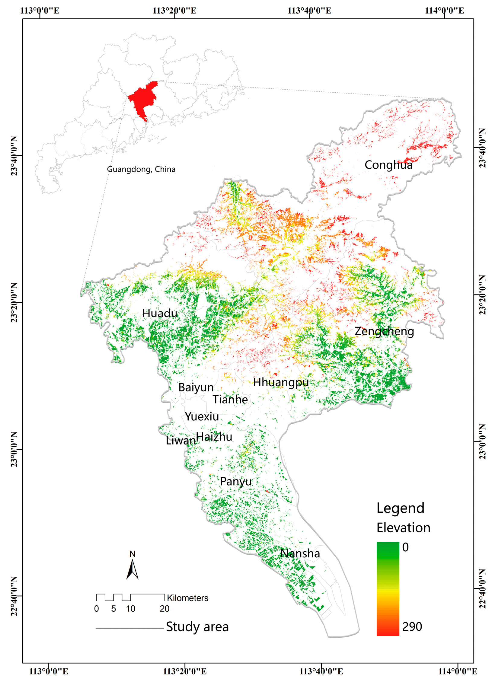
Guangzhou is located in the southern part of Guangdong Province (longitude 112°57′ to 114°3′, latitude 22°26′ to 23°56′) (Figure 1) and encompasses 11 districts, including Yuexiu, Liwan, Tianhe, Conghua, and Zengcheng. It covers an area of 7434.40 square kilometers and represents the political, economic, technological, educational, and cultural center of Guangdong Province. The terrain of Guangzhou is diverse, and the area of forest land is the largest, accounting for 39.45% of the total area of the city, followed by cropland accounting for 22.24%, water area accounting for 11.87%, urban area accounting for 10.74%, garden land accounting for 8.45%, traffic land accounting for 5.10%, unused land accounting for 2.12%, and grassland accounting for only 0.03%. The cropland in the territory is mostly paddy soil, latosolic red soil, etc., with sufficient soil fertility and rich organic matter, which is suitable for planting rice, vegetables and other crops. In 2020, the added value of Guangzhou’s primary industry will be 28.808 billion yuan, and the annual grain output will be 142,200 tons. Guangzhou is a representative of rapidly urbanizing coastal areas, resulting in the substantial transformation of cropland into urban areas. According to statistics, the area of cropland in Guangzhou decreased from nearly 1350 km2 in 2005 to 1120 km2 in 2010, then to 960 km2 in 2015, and finally to 870 km2 in 2020. The rapid economic development in the Guangzhou metropolitan area has affected traditional agricultural production, resulting in multiple functions provided by cropland and complex relationships. The sustainable utilization of arable land resources is crucial.
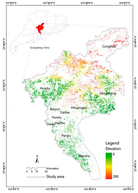
Figure 1.
Study area location.
2.2. Data Sources
2.2.1. Cropland-Use Data
Cropland-use data were obtained from the GlobeLand30 cover data website (http://www.globalcroplandcover.com) accessed on 1 June 2021. The data have a spatial resolution of 30 m and an accuracy of 85.72%. Cropland-use data for 2020 were extracted from this source. Data on irrigation, drainage, and cropland quality were acquired from government departments.
2.2.2. Soil Data
The soil data were obtained from the Guangdong Joint Fund of the National Natural Science Foundation of China, consisting of data from 738 soil samples in Guangzhou. The soil attributes included soil organic matter content, soil pH, and other data based on laboratory analyses. Digital soil mapping was used to obtain the spatial distribution of soils.
2.2.3. Other Geographic Data
The other geographic data included terrain, meteorological, and vegetation information. A digital elevation model (DEM) with a 30 m resolution was acquired from the Geographic Spatial Data Cloud website (http://www.gscloud.cn) accessed on 1 June 2021. Slope and aspect data were derived from the DEM using 3D analysis tools in ArcGIS 10.2, enabling the extraction of raster data. Meteorological data were obtained from various sources, including the National Earth System Science Data Center (http://www.geodata.cn) accessed on 2 June 2021and the Resource and Environment Science Data Center (http://www.resdc.cn) accessed on 2 June 2021. Normalized Difference Vegetation Index (NDVI) data were derived from the MOD13Q1v061 dataset, and Net Primary Productivity (NPP) data were derived from the MOD17A3HGFv061 dataset provided by the NASA Land Processes Distributed Active Archive Center.
2.2.4. Social and Economic Data
Population data were sourced from WorldPop. Data on grain production, agricultural value, production inputs (pesticide and fertilizer usage), and other statistical information were obtained from the Guangdong Provincial Rural Statistical Yearbook and the Guangzhou Statistical Yearbook.
2.3. Research Methodology
2.3.1. Cognitive Framework Based on Sustainable Utilization of Cropland
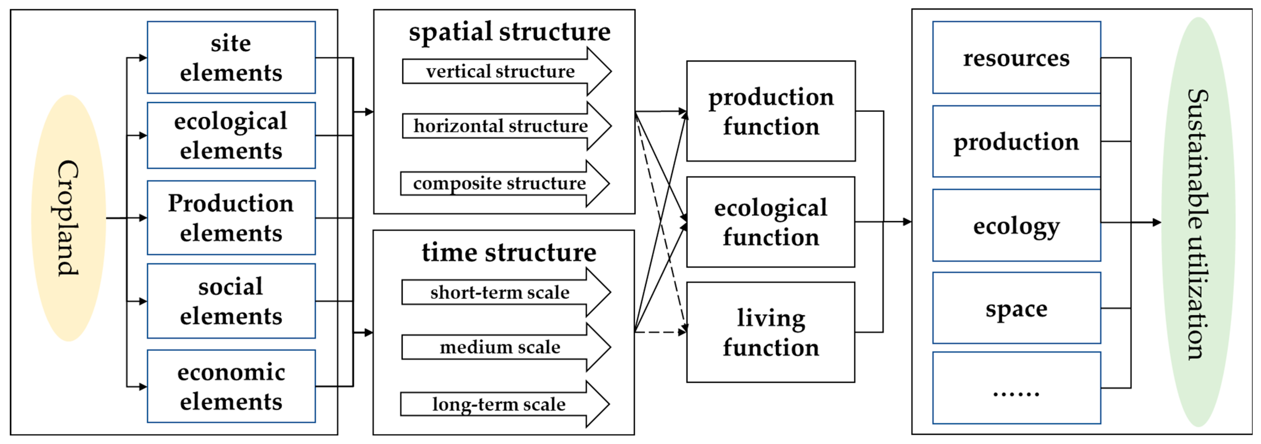
Cropland is a comprehensive system affected by the natural environment and human activities. It is affected by factors such as site, ecology, production, society, and economy. The coupling of its constituent elements and the diversity of cropland use give cropland multiple functional attributes, such as production, ecology, and life [37,38]. In this article, the cropland resources are recognized as a unified organic whole. The system analysis method is used to analyze the elements and functions of the cropland system. The inductive deduction method is used to explore the internal composition and external performance of the cropland system. The cognitive framework for the sustainable utilization of cropland resources is constructed, as shown in Figure 2.
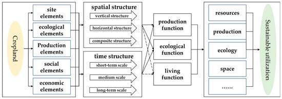
Figure 2.
Cognitive framework of sustainable utilization of cropland.
Under the combination of different elements, the production function of the cropland system is realized through the water, soil, gas, biological, and photosynthetic processes of the vertical structure of the system space, mainly including external energy inputs such as solar radiation, artificial inputs, etc., and the output process of agricultural products [35,36]. The ecological function of the system is manifested as the regulation and buffering of the cropland system and the external environment. It is mainly composed of the horizontal structure of the background elements and the ecological elements, reflecting the spatial pattern of the cropland system [39,40]. The living function reflects the social and economic value of the cropland system in a composite structure in the system, which is mainly the process of forming input and output products and services with the external environment. In the aspect of sustainable resource utilization, it includes the realization of the red line of cropland, the reduction in cropland resources, the improvement of cropland production capacity and product quality, the maintenance of ecological balance, the maintenance of ecological security, the improvement of resource management level, and the improvement of land space allocation efficiency. According to the changes in the external environment and the adjustment of human needs, it further serves the utilization and protection of resources and finally forms a harmonious and sustainable utilization of cropland systems.
2.3.2. The Multifunctional Evaluation Index System and Calculation Method of Cropland Resources
The result of a multifunctional assessment of cropland resources must be accurate and reliable. Thus, a valid indicator system is required to evaluate the results and ensure practical applicability. The proposed multifunctional assessment indicator system for cropland resources is science-based, comprehensive, and focused on practical applications.
The multifunctional assessment indicators consider the characteristics of the evolution of cropland in rapidly urbanizing areas [35,36,41]. It includes 11 indicators, such as soil pH, irrigation rate, organic matter content, grain production, and others. The indicators are listed in Table 1.

Table 1.
Multifunctional evaluation indicator system for cropland resources.
Subjective and objective weighting methods have been used to determine indicator weights. Both have advantages and limitations. This paper uses subjective analysis and objective weight assignment, i.e., the Analytic Hierarchy Process (AHP) and Entropy Method, to determine the indicator weights in the multifunctional assessment of cropland resources.
The AHP includes establishing a hierarchical structure, creating pairwise comparison matrices, hierarchical ranking, and the calculation of the consistency ratio (CR), which is the ratio of the consistency index (CI) to the random consistency index (RI):
where represents the maximum eigenvalue of the evaluation matrix, and n is the number of indicators.
The CR is defined as follows:
where represents the criterion layer weights, CI is the consistency index, and RI is the random consistency index.
The entropy method is based on the information entropy theory. It is used to determine objective weights based on the magnitude of the indicator variability. A smaller information entropy value indicates a higher degree of dispersion and more information contained in the indicators, resulting in larger weights. The calculation steps are as follows:
Data standardization involves transforming all raster data into dimensionless, standardized values. For a functional category with j indicators and i data points, the standardization is applied as follows:
where represents the standardized score of the j-th data point for indicator i. is the i-th data value for indicator j. represents all data values for indicator j.
Finally, we calculate the combined weights for each indicator. The entropy method is used to compute the difference coefficient, and the AHP is used to adjust the subjective weights, resulting in the optimized combined weights . The calculation formula is as follows:
The indicator weights are listed in Table 2.

Table 2.
Weights of multifunctional evaluation indicators for cropland resources.
2.3.3. Key Indicators for the Multifunctional Evaluation of Cropland Resources
- (1)
- Grain production volume
The NPP is used to assess crop production capacity [27] because it is a comprehensive indicator that considers the effects of natural factors, such as light, temperature, water, and soil, and human activities, and it can be estimated using remote sensing data. Therefore, this article utilizes the crop yield data from the statistical yearbook of the counties and the proportion of NPP values for each grid in the county to obtain the grain production volume [45,46]. The calculation formula is as follows:
where is the grain production volume in grid i, is the total grain production volume in region j, is the NPP value of grid i, and is the total NPP of cropland in region j.
- (2)
- Landscape fragmentation
The patch density (PD) is used to reflect the fragmentation of cropland. It indicates the intensity of human disturbances to the cropland landscape. A higher PD indicates higher fragmentation. Crops with low fragmentation indicate higher biodiversity and vice versa. High fragmentation reduces the ability of cropland to provide ecological functions. The calculation formula is as follows:
where PD represents the patch density, NP is the number of patches in the region, and A is the total area of the patches.
PD = NP − A
- (3)
- Aggregation Index
The aggregation index is a commonly used indicator in cropland scape pattern analysis. It measures the degree of concentration of cropland in a region and the spatial distribution of cropland. A higher aggregation index indicates a more concentrated spatial distribution, and a lower index suggests a more dispersed distribution. A higher aggregation index corresponds to the greater ability of cropland to provide ecological functions. The formula for calculating the aggregation index is as follows:
where AI represents the aggregation index for cropland. Xi is the area of cropland in the region, T is the total area of cropland, and n is the number of regions.
- (4)
- Environmental Load of Cropland
The environmental load refers to the input of production materials, such as chemical fertilizers, rather than organic fertilizers. When this input exceeds a threshold, environmental problems can occur, such as soil compaction and reduced biodiversity, reducing environmental quality. A high environmental load reduces the ability of cropland to provide ecological functions. We allocate the amount of chemical fertilizer usage reported in the statistical yearbook for each county to the cropland based on the grid. The formula is as follows:
where represents the environmental load of the cropland in grid i. is the amount of fertilizer usage in county j. is the area of cropland in grid i. is the total area of cropland in county j.
Based on the calculation results of the key indicators and weights mentioned above, the extreme value method is used to standardize the indicator data, and the comprehensive analysis method is used to carry out multifunctional evaluation of cropland. The calculation formula for the functional value F of cropland is as follows:
where is the evaluation of single function n (n = 1, 2, 3), the value is between 0 and 1 (the closer to 1), the better the function performance; k is the number of samples; is the weight of the pth index; and is the pth index value of the qth sample.
2.3.4. Analysis of Synergistic and Trade-Off Relationships of the Cropland’s Functions
Cold or hot spot analysis is used in geospatial information science to determine the spatial autocorrelation of geographic variables. Its advantage is that it provides accurate spatial clustering of high or low values of functions [47,48]. A hot spot with significant statistical significance is an area with high values surrounded by other elements with high values. The Getis–Ord (Gi*) index is calculated in the cold/hot spot analysis of cropland functions to determine the synergistic relationships between cropland functions. The calculation formula is as follows:
where represents the attribute value of feature j, and represents the spatial weight between features j and i.
The statistical significance of the Gi* index is assessed using the standardized Z-value. A positive Z-value and higher values indicate a tighter clustering of hotspots. Conversely, a negative Z-value and lower values suggest a tighter clustering of cold spots.
3. Results
3.1. Evaluation of Cropland Production Function
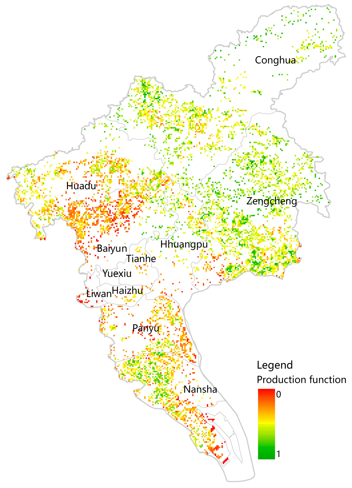
The cropland production function indicates the potential of producing food to meet the material needs for human survival and development. The evaluation results are shown in Figure 3. The proportion of the cropland production function in Guangzhou is good. Guangzhou is located in the Pearl River Delta region, which is characterized by a humid and warm climate with abundant rainfall. The predominant soil types are red soil, lateritic red soil, and clayey red soil, with a high iron content, moderate texture, deep soil layers, and fertile soil. The relatively flat terrain and favorable agricultural conditions make it suitable for cultivating subtropical crops. Areas with high production capacity are located in the Zengcheng and Conghua regions. Zengcheng and Conghua have long-term cultivation areas, benefiting from abundant rainfall and warm conditions. They possess substantial agricultural production potential. The abundant sunlight, adequate precipitation, and convenient transportation networks provide unique advantages for agricultural production. Zengcheng is renowned for its high-quality rice production and is known as the “King of Rice in China”. These regions are vital for food production in Guangdong Province. Due to accelerated urbanization, the Tianhe, Yuexiu, Liwan, Haizhu, Panyu, and Baiyun areas have experienced a significant reduction in cropland area. Zengcheng and Conghua are among the few regions with relatively stable cropland areas in Guangzhou. Their agricultural production capacity changes at a relatively slow rate, even under urbanization. However, the areas most affected by urbanization are the Nansha and Huadu districts. It is essential to strengthen the management of cropland resources in these regions to enhance their production capacity.
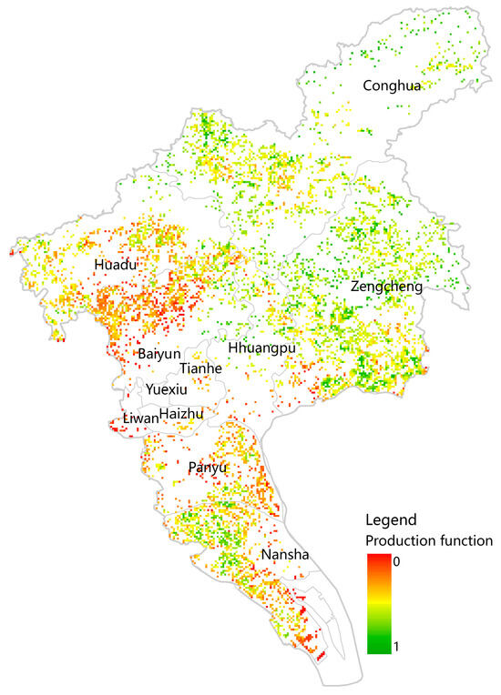
Figure 3.
Evaluation results of the cropland production function in Guangzhou.
3.2. Evaluation of Cropland Ecological Function
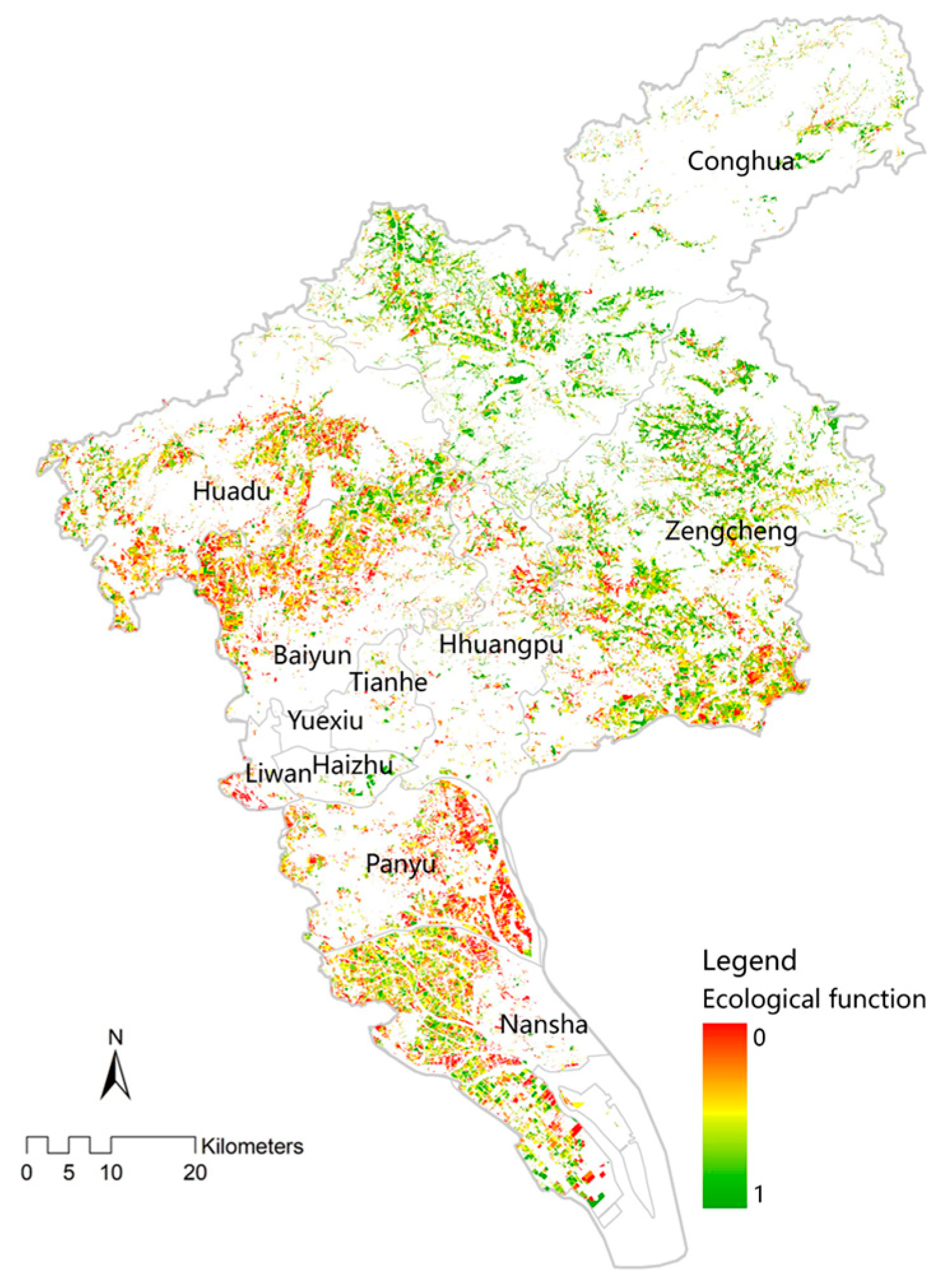
The ecological function of cropland resources refers to the physical, chemical, and biological processes contributing to a stable environment. The evaluation results of the ecological function of cropland resources in Guangzhou are shown in Figure 4. The results are favorable. This finding indicates that Guangzhou has made progress in promoting new technologies for reducing fertilizer usage and increasing efficiency despite the widespread increase in chemical fertilizers and pesticides, which has intensified the environmental load on cropland resources. This effort has contributed to the green and high-quality development of agriculture. Furthermore, Guangzhou has constructed several national wetland parks, increasing the biological diversity of cropland resources. High-value areas are concentrated in the high-altitude areas of the Zengcheng and Conghua districts and in agricultural production areas far from urban development. These areas experience less urban development, resulting in less interference from transportation networks. As a result, the degree of anthropogenic factors affecting the ecological functions of cropland resources is lower. These areas have a stronger capacity for soil carbon sequestration, higher rates of vegetation cover, and a healthier environment. Other high-value areas are distributed in the Huadu, Huangpu, and Nansha districts. The Nansha District is highly representative. As an important port area in Guangzhou, the Nansha District has a dense network of waterways, flat terrain, and excellent conditions for vegetation growth. The environment around the cropland is favorable. The Nansha District Government has constructed an urban ecological greening network composed of ecological conservation areas, landscape protection areas, and urban green network areas, and it has built the ‘world’s most livable city’. The low value areas are located in Panyu District, Baiyun District and the southern part of Zengcheng. The region is located in the suburban junction with a high degree of industrial agglomeration. A large number of people are engaged in industrial production, and agricultural production activities are reduced, resulting in low ecological function value.
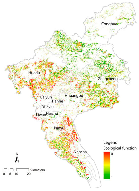
Figure 4.
Evaluation results of the cropland ecological function in Guangzhou.
3.3. Evaluation of Cropland Living Function
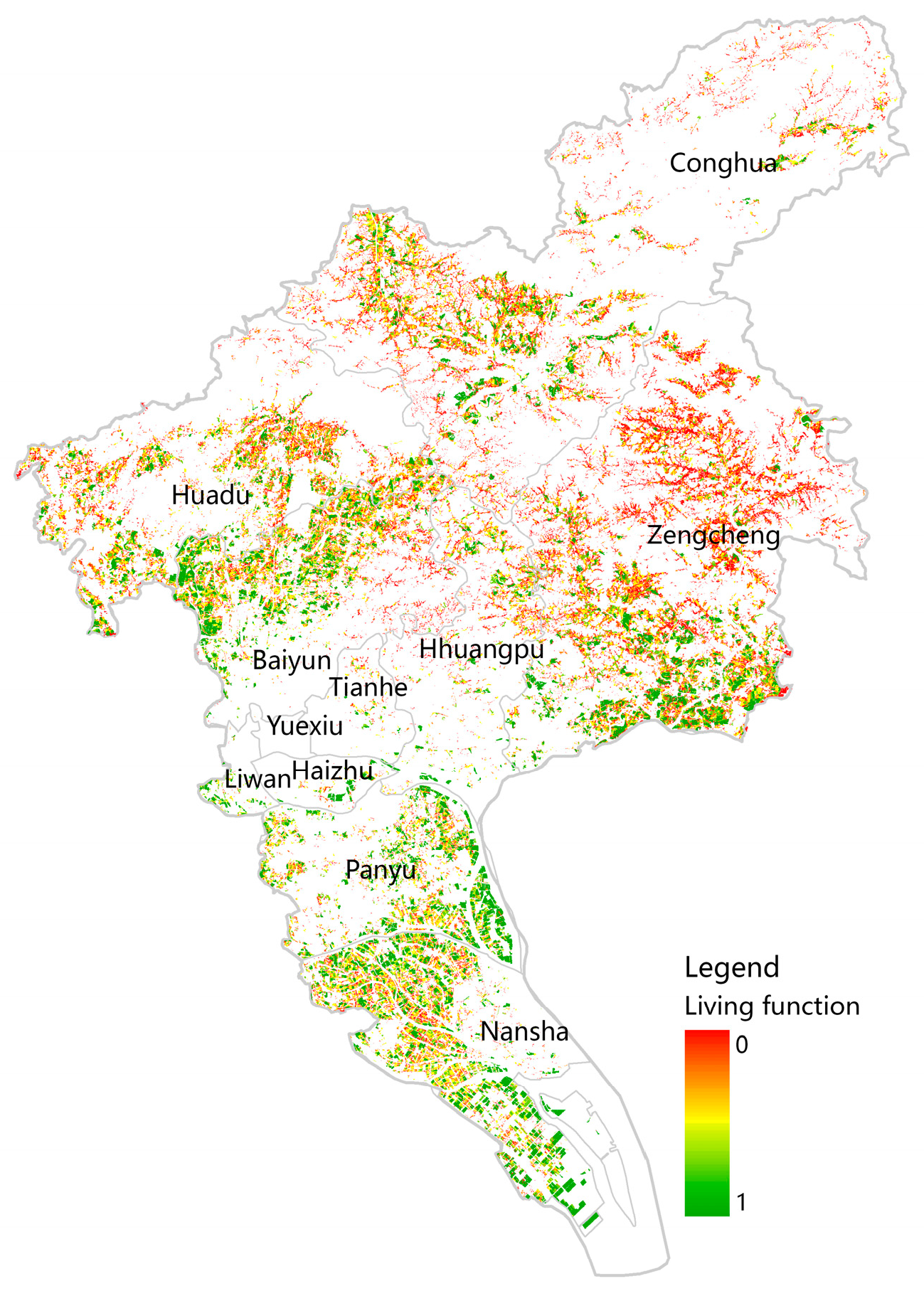
The living function of cropland represents the ability of cropland resources to maintain social stability, provide cultural products, ensure national food security, and support social stability, employment, and production in rural areas. Cultural products satisfy human cultural and spiritual needs. The evaluation results of the cropland living function in Guangzhou are shown in Figure 5. The living function is relatively low. For the traditional agricultural production areas with high altitude in Zengcheng District and Conghua District, as urbanization has increased, the ability of cropland to provide employment has decreased. Rural employment opportunities have increased, and the rural social security system has become more robust due to strong urban–rural industrial connections and a balanced and integrated industrial system between urban and rural areas. Some farmers in rural areas have left to work in urban areas, decreasing the ability of cropland to provide a living function. High-value areas for the living function of cropland resources are concentrated in the peri-urban areas, reflecting the higher demand of urban residents for cultural products from cropland resources. This is especially evident in areas close to cultural heritage sites, characteristic towns, and agricultural tourism attractions. Typical examples include the southern part of Nansha District and the southern part of Zengcheng District. These areas have experienced rapid development in rural tourism and agricultural sightseeing. Cropland-scale management has increased, allowing some farmers to stabilize their employment and income from cropland. More employment opportunities have been provided to farmers after the establishment of the Nansha National Economic and Technological Development Zone, reducing the income gap between farmers and urban residents and maintaining social stability.
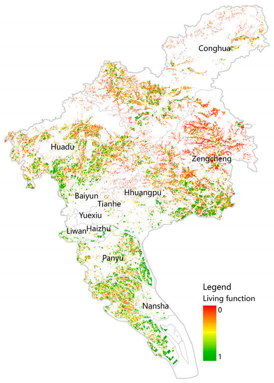
Figure 5.
Evaluation results of the cropland living function in Guangzhou.
3.4. Analysis of Synergistic and Trade-Off Relationships between the Function of Cropland Resources
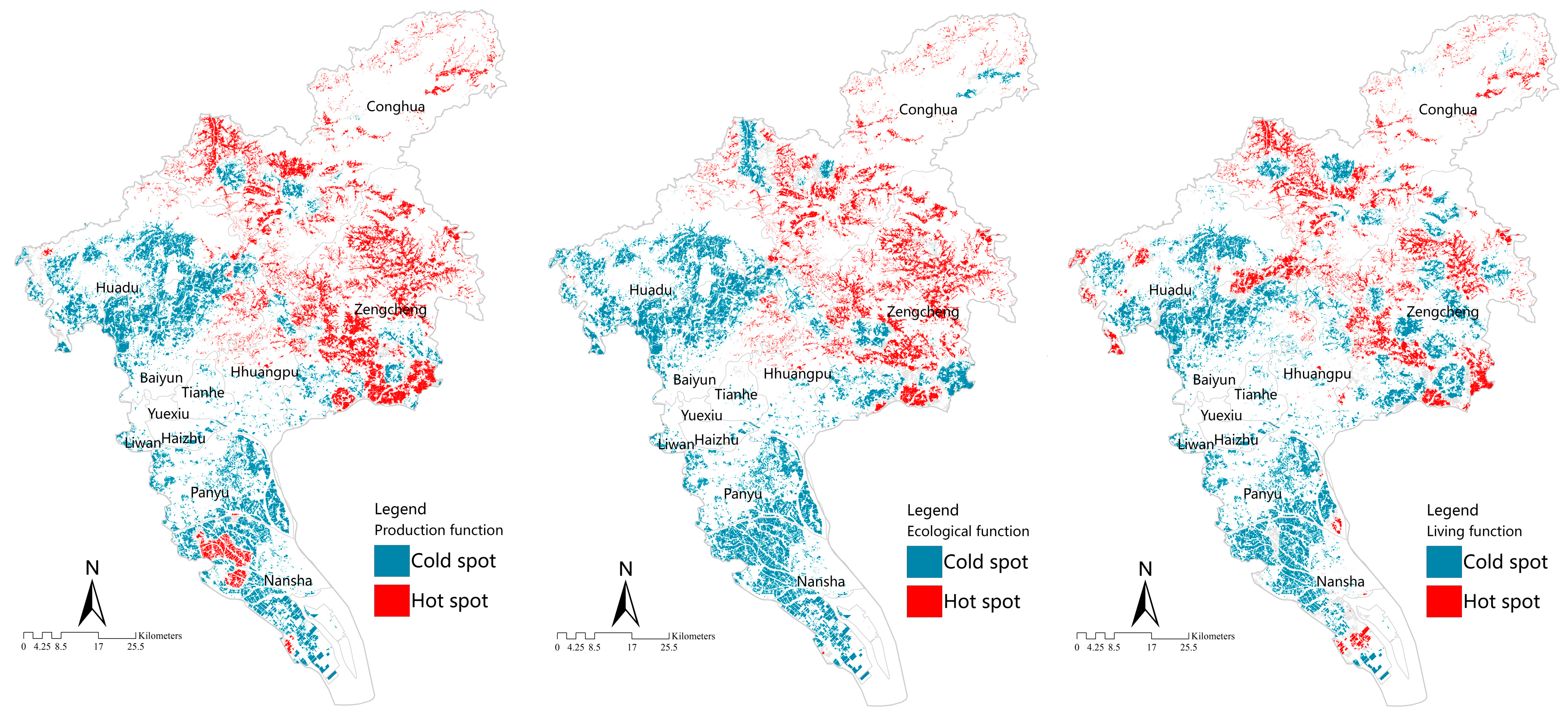
As shown in Figure 6, the spatial distribution of hot and cold spots is consistent with the production, ecological, and living functions of cropland resources. A regional gradient is observed, which is characterized by hot spots in the northeast and cold spots in the southwest. The hot spots for the production function are concentrated in the western part of the Zengcheng, Conghua, and Nansha districts, where grain production is high. In contrast, the cold spots for the production function are in the urban areas of Baiyun, Tianhe, Yuexiu, Liwan, Panyu, and Huadu districts, with extensive cropland resources. The hot spots for ecological function are observed in the Zengcheng and Conghua Districts, whereas the cold spots are clustered in areas with rapid urban development, such as Baiyun, Tianhe, Yuexiu, Liwan, Panyu, Nansha, and Huadu. The hot spots for the living function are primarily found in the western parts of Zengcheng, Conghua, and Huadu Districts and in the southern parts of the Nansha District. These results provide insights into the spatial distribution of the different functions of cropland resources in Guangzhou and their trade-off and synergy relationships.
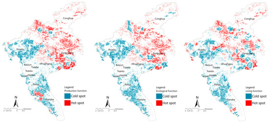
Figure 6.
Spatial distribution of cold and hot spots of cropland resources.
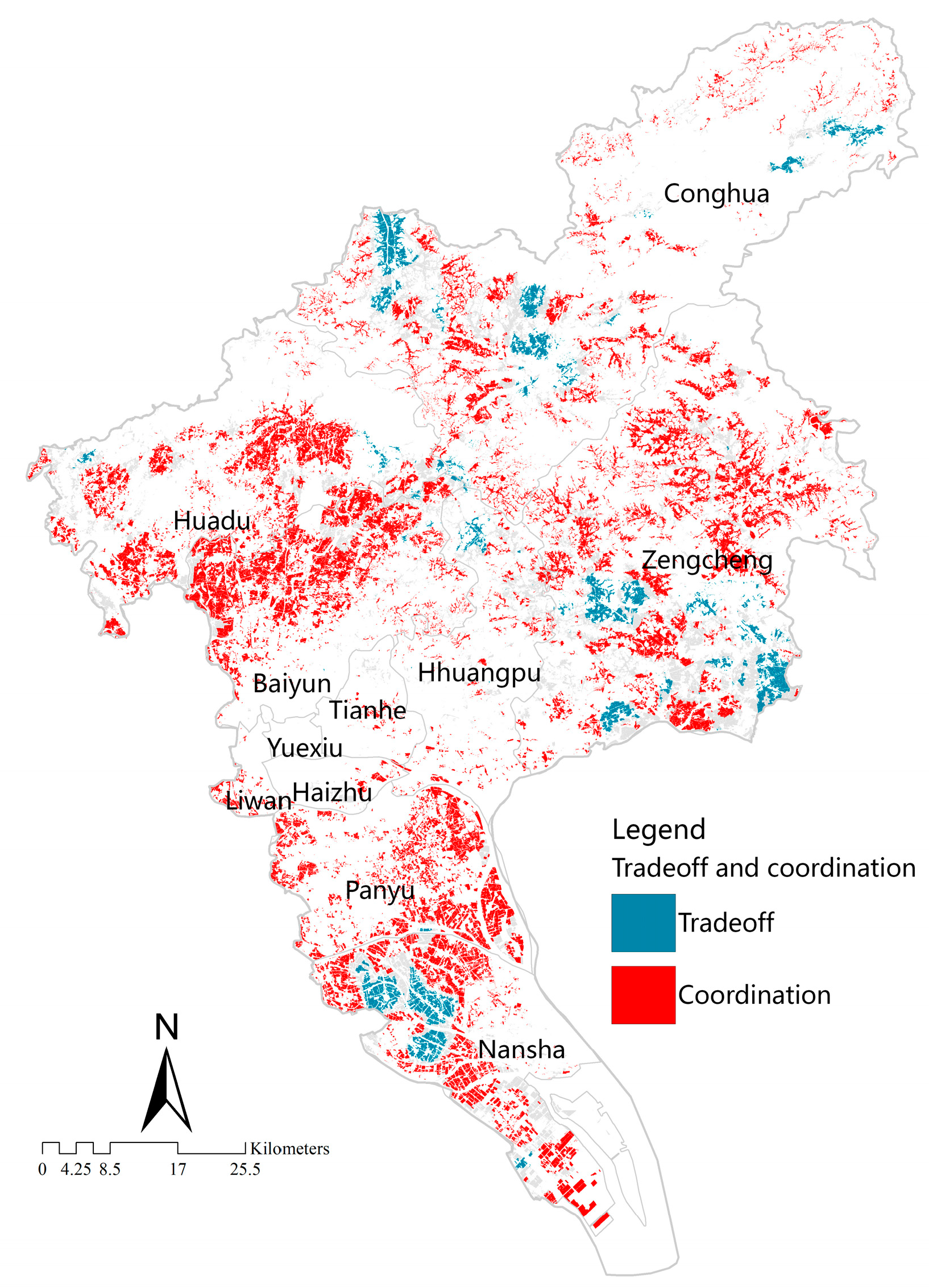
The results of the cold or hot spot analysis were overlayed, resulting in four categories: hot–hot, hot–cold, cold–hot, cold–cold (there are also areas where the cold or hot relationship is not significant; these were excluded). A trade-off relationship occurs in the hot–cold and cold–hot areas, and a synergistic relationship occurs in the hot–hot and cold–cold areas. The results are shown in Figure 7. A synergistic relationship occurs in most areas of Guangzhou (91%). Although Guangzhou is in a rapid urbanization area, which can adversely affect cropland resources, the protection of the environment is dominant. In addition to the excellent agricultural production conditions, the increase in agricultural tourism, intelligent agriculture, and other industries has resulted in more interest in the cultural value of cropland. With increased agricultural development and industrialization, the farmers around the city have been able to obtain a stable income and increase their employment opportunities. These conditions ensure agricultural production and have narrowed the income gap between farmers and urban residents, maintaining social stability. Multiple factors have contributed to this phenomenon in areas with trade-off relationships, such as the southern part of Zengcheng, the northwestern and northeastern parts of Conghua, and the western part of Nansha. The ecological function of cropland is higher in remote mountainous areas, although transportation accessibility is low, and these areas have few cropland areas. The fragmentation of cropland in high-altitude areas is not conducive to large-scale mechanized planting, resulting in low cropland productivity of cropland and a low production function. Few croplands exist in areas with high levels of economic development around the city, making it difficult for farmers to survive. Significant industrial activities and pollution have hindered the ability of cropland to provide ecological functions. Therefore, it is necessary to focus on cropland resource management and future protection strategies in the trade-off areas in order to take measures to improve and repair the cropland resources and enhance their comprehensive value.
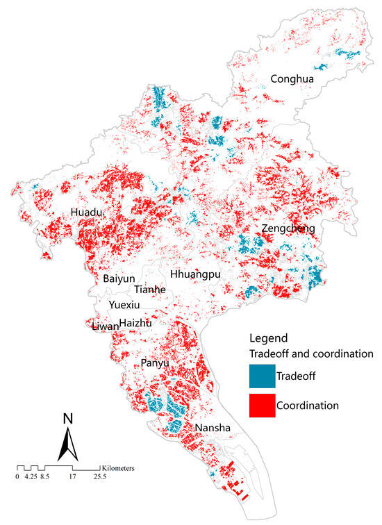
Figure 7.
Spatial distribution of multifunctional trade-off and synergistic relationships in Guangzhou.
4. Discussion
This article proposes a new research perspective to establish a cognitive framework to analyze the functions of sustainable utilization provided by cropland resources. The production, ecological, and living functions of the cropland system were investigated. The aim was to provide theoretical support for assessing the synergistic relationships among multiple functions of cropland resources. The evaluation indicators were selected based on Chinese and international research. Examples include the soil pH and organic matter content (Kong et al. [22]), irrigation rate (Zhao et al. [23]), and grain production volume (Fan et al. [25]). A combination of subjective analysis and objective weight assignment was employed using the AHP–Entropy method for assigning indicator weights. This approach ensured the objectivity and reliability of the evaluation results and has been successfully applied in similar studies [27,49], achieving satisfactory outcomes.
However, differences in the calculation methods and data sources for multifunctional evaluation indicators have resulted in numerical disparities [50,51]. The production function of cropland resources in Guangzhou is good. Our results are in good agreement with actual conditions and are similar to those of Wu [52] and others. The ecological function evaluation results of cropland resources in Guangzhou is favorable. This result can be attributed to Guangzhou City’s vigorous promotion of new technologies to reduce fertilizer use and increase efficiency, supporting the green and high-quality development of agriculture, and implementing policies such as the establishment of national wetland parks. The evaluation results for the living function of cropland resources in Guangzhou is relatively low. High-value areas are concentrated around the city, and some are located in the mountainous areas in the Conghua District and some areas of Huadu District. These findings are similar to those of Zang [44] and others. The analysis of the synergy between the multiple functions of cropland resources was based on the cognitive theory of cropland resources, which considers elements, functions, and values [4]. Using hot spot analysis to assess the spatial clustering patterns of high- and low-value areas for different functions of cropland resources, we find out that a synergistic relationship occurred in most areas of Guangzhou City, accounting for 91%. A balanced relationship was only observed in some areas of the southern part of Zengcheng District, the northwestern and northeastern parts of Conghua District, and the western part of Nansha District. In contrast to studies on ecosystem services that found a strong, balanced relationship between production and ecological functions [53,54], such as agricultural planting inhibiting ecological functions, the focus of this article was on cropland, where the production function is the most critical.
In the rapid urbanization area, the change in cropland resources is complex and unique. It is necessary to take cropland as a special resource and carry out systematic cognition and practice from the perspective of coupling, functional synergy and value service of cropland system elements. Therefore, from the new perspective of cropland resource element–function–value, this paper analyzes the cropland resource system, deconstructs the operation mechanism of cropland resources, and constructs the cognitive framework of the cropland resource system. This provides a way of thinking for the systematic understanding of cropland resources in rapid urbanization areas, and it also provides a basis for managers to scientifically guide the sustainable utilization of cropland resources. In addition, it also further enriches the cognitive theory system of cropland resources. For the weighing area, the policy suggestions for the management and protection of cropland resources in Guangzhou are put forward, which makes up for the deficiency of the application of the value-oriented management and protection strategy model in the management of cropland resources, and it can provide a reference for the management and protection of cropland resources in other rapid urbanization areas. But this article also has several limitations. The evaluation indicator system has room for improvement due to limitations in cognitive levels and data. The evaluation of multifunctionality and the analysis of the synergistic and balanced relationships among the functions of cropland can provide information on cropland zoning and management to enhance the effectiveness of land protection strategies and promote the sustainable use of cropland resources. The article was conducted at the parcel level, and the multifunctional services and synergistic and balanced relationships of cropland were assessed at the city scale. However, subsequent research is required at the county scale, focusing on different towns or villages to formulate targeted and fine-scale management strategies [55,56,57]. Additionally, this article investigated the synergistic and balanced relationship of cropland functions from a global perspective to formulate government management strategies. However, the synergistic and balanced relationships between different functions have not been discussed in sufficient detail. Future research will focus on this aspect. In general, the theoretical framework proposed in this study has a certain reference value for the management of cultivated land resources, and it can promote the sustainable utilization and protection of cultivated land resources in rapidly urbanized areas.
5. Conclusions
This article designs a cognitive framework for the sustainable utilization of cropland resources from the perspective of the system. The production, ecological, and living functions provided by cropland resources were assessed, and the synergistic and balanced relationships between the functions were determined. Guangzhou, a representative city characterized by rapid urbanization, was used as an example. Spatial and cold/hot spot analyses were conducted.
The spatial distribution of the multifunctional evaluation results of cropland resources in Guangzhou showed that the production function of cropland resources in Guangzhou is good, the ecological function is favorable, and the living function is relatively low. A synergistic relationship between the three functions occurred in most areas of Guangzhou (91%). Some areas in the south of the Zengcheng District, parts in the north-west and northeast of the Conghua District, and parts in the west of the Nansha District showed a trade-off relationship due to low transportation accessibility and few areas of cropland. The cropland in this area did not provide sufficient products. These factors should be considered when formulating management and protection strategies for cropland resources.
The orderly and stable development of the multifunctionality of cropland is the basis for ensuring the sustainable use of cropland. Therefore, in the subsequent process of cropland use, based on the framework of sustainable use, researchers should pay attention to the coupling of elements and the synergy of functions, especially in the functional synergy area. It is necessary to maintain the stability of cropland functions and prevent the degradation of functions. For the trade-off area, it is necessary to take measures to improve and repair the cropland resources and enhance their comprehensive value.
Author Contributions
Conceptualization, R.Z., X.M., Y.H., L.L., H.Y. and Y.P.; methodology, R.Z. and H.Y.; validation, R.Z. and Y.P.; formal analysis, R.Z., X.M. and H.Y.; investigation, R.Z.; resources, X.M., Y.H. and L.L.; data curation, R.Z., Y.P. and H.Y.; writing—original draft preparation, R.Z., Y.P. and H.Y.; writing—review and editing, R.Z., L.L., H.Y. and Y.P.; project administration, X.M.; funding acquisition, Y.H. All authors have read and agreed to the published version of the manuscript.
Funding
This research was funded by the National Natural Science Foundation of China (U1901601) and the Science and Technology Innovation Project by the Department of Natural Resources of Jiangxi Province (ZRKJ20222305).
Data Availability Statement
Data are contained within the article.
Acknowledgments
We greatly acknowledge Zhenhua Liu, Yongzhong Tan and Lu Wang for their strong support in the course of writing.
Conflicts of Interest
The authors declare no conflicts of interest.
References
- Tramberend, S.; Fischer, G.; Bruckner, M.; van Velthuizen, H. Our common cropland: Quantifying global agricultural land use from a consumption perspective. Ecol. Econ. 2019, 157, 332–341. [Google Scholar] [CrossRef]
- Hu, Y.; Yang, H.; Zou, R. Evolution and prospect of systematic cognition on the cultivated land resources. J. Agric. Resour. Environ. 2021, 38, 937–945. [Google Scholar]
- Eitelberg, D.A.; van Vliet, J.; Verburg, P.H. A review of global potentially available cropland estimates and their consequences for model-based assessments. Glob. Change Biol. 2015, 21, 1236–1248. [Google Scholar] [CrossRef]
- Sun, X.; Kong, X.; Wen, L. Evaluation Index System of Cultivated Land Quality and its Development Trend Based on Cultivated Land Elements. Chin. J. Soil Sci. 2019, 50, 739–747. [Google Scholar]
- Ridoutt, B.; Garcia, J.N. Cropland footprints from the perspective of productive land scarcity, malnutrition-related health impacts and biodiversity loss. J. Clean. Prod. 2020, 260, 121150. [Google Scholar] [CrossRef]
- Fu, B. Approaches and methods of comprehensive geographical research: Pattern and process coupling. Acta Geogr. Sin. 2014, 69, 1052–1059. [Google Scholar]
- Dumanski, J.; Pieri, C. Land quality indicators: Research plan. Agric. Ecosyst. Environ. 2000, 81, 93–102. [Google Scholar] [CrossRef]
- Sünnemann, M.; Beugnon, R.; Breitkreuz, C.; Buscot, F.; Cesarz, S.; Jones, A.; Lehmann, A.; Lochner, A.; Orgiazzi, A.; Reitz, T.; et al. Climate change and cropland management compromise soil integrity and multifunctionality. Commun. Earth Environ. 2023, 4, 394. [Google Scholar] [CrossRef]
- Sylla, M.; Hagemann, N.; Szewrański, S. Mapping trade-offs and synergies among peri-urban ecosystem services to address spatial policy. Environ. Sci. Policy 2020, 112, 79–90. [Google Scholar] [CrossRef]
- Sun, X.; Kong, X.; Wen, L. Research on the cultivated land quality evaluation index system based on cultivated land elements and its development trend. Soil Bull. 2019, 50, 241–249. [Google Scholar]
- Ceccarelli, T.; Bajocco, S.; Luigi, P.L.; Luca, S.L. Urbaniation and land take of high quality agricultural soils—Exploring long-term land use changes and land capability in northern Italy. Int. J. Environ. Res. 2013, 8, 181–192. [Google Scholar]
- Duan, J.; Liu, S.; Li, P. Article on Research Progress and Directions of Land Functions. China Land Sci. 2020, 34, 8–16. [Google Scholar]
- Su, C.; Fu, B. Discussion on Links Among Landscape Pattern, Ecological Process, and Ecological Services. Chin. J. Nat. 2012, 34, 277–283. [Google Scholar]
- Lin, X.; Hu, Y.; Wang, G.; Fan, S. Analysis of functional connection and spatial pattern of Pearl River Delta urban agglomeration base on multi-element factor flows. World Reg. Stud. 2020, 29, 536–548. [Google Scholar]
- Tong, Q.; Chi, B. Multi-dimension Analysis of Cultivated Land Change Based on Land Use Spatial-temporal Database. Geospat. Inf. 2016, 14, 85–96. [Google Scholar]
- Karamesouti, M.; Detsis, V.; Kounalaki, A.; Vasiliou, P.; Salvati, L.; Kosmas, C. Land-use and land degradation processes affecting soil resources: Evidence from a traditional Mediterranean cropland (Greece). Catena 2015, 132, 45–55. [Google Scholar] [CrossRef]
- Kooch, Y.; Ghorbanzadeh, N.; Kuzyakov, Y.; Praeg, N.; Ghaderi, E. Investigation of the effects of the conversion of forests and rangeland to cropland on fertility and soil functions in mountainous semi-arid landscape. Catena 2022, 210, 105951. [Google Scholar] [CrossRef]
- Godfray, H.C.J.; Beddington, J.R.; Crute, I.R.; Haddad, L.; Lawrence, D.; Muir, J.F.; Pretty, J.; Robinson, S.; Thomas, S.M.; Toulmin, C. Food security: The challenge of feeding 9 billion people. Science 2010, 327, 812–818. [Google Scholar] [CrossRef]
- Martin-Guay, M.-O.; Paquette, A.; Dupras, J.; Rivest, D. The new Green Revolution: Sustainable intensification of agriculture by intercropping. Sci. Total Environ. 2017, 615, 767–772. [Google Scholar] [CrossRef]
- Mamkhezri, J.; Muhamad, G.M.; Khezri, M. Assessing the spatial effects of economic freedom on forest-products, grazing-land, and cropland footprints: The case of Asia-Pacific countries. J. Environ. Manag. 2022, 316, 115274. [Google Scholar] [CrossRef]
- Peng, H.; Zhang, X.; Ren, W.; He, J. Spatial pattern and driving factors of cropland ecosystem services in a major grain-producing region: A production-living-ecology perspective. Ecol. Indic. 2023, 155, 111024. [Google Scholar] [CrossRef]
- Xin, Y.; Kong, X.; Yun, W. Design and Application of Multi-functional Evaluation Index System for Cultivated Land in Metropolitan Fringe of Beijing: A Case Article in Daxing District. China Land Sci. 2017, 31, 77–87. [Google Scholar]
- Wang, R.; Zhao, X.; Zhao, L.; Guo, X. Multi-function evaluation and functional zoning of suburban cultivated land using MCR-InVEST model. Trans. Chin. Soc. Agric. Eng. 2022, 38, 209–219. [Google Scholar]
- Ishikawa, Y.; Yamazaki, D. Global high-resolution estimation of cropland suitability and its comparative analysis to actual cropland distribution. Hydrol. Res. Lett. 2021, 15, 9–15. [Google Scholar] [CrossRef]
- Fan, Y.; Gan, L.; Hong, C.; Jessup, L.H.; Jin, X.; Pijanowski, B.C.; Sun, Y.; Lv, L. Spatial identification and determinants of trade-offs among multiple land use functions in Jiangsu province, China. Sci. Total Environ. 2021, 772, 145022. [Google Scholar] [CrossRef]
- Qian, F.; Chi, Y.; Lai, R. Spatiotemporal characteristics analysis of multifunctional cultivated land: A case-article in Shenyang, northeast China. Land Degrad. Dev. 2020, 31, 1812–1822. [Google Scholar] [CrossRef]
- Luo, S.; Lai, Q.; Wang, X. Control and management of cropland regionalization in Fujian Province of China using multi-functional evaluation and trade-off-synergy relationships. Trans. Chin. Soc. Agric. Eng. 2023, 39, 271–280. [Google Scholar]
- Xiong, C.; Zhang, Y.; Wang, Y.; Luan, Q.; Liu, X. Multi-function Evaluation and Zoning Control of Cultivated Land in China. China Land Sci. 2021, 35, 104–114. [Google Scholar]
- Qiu, J.; Turner, M. Spatial interactions among ecological services in an urbanizing agricultural watershed. Proc. Natl. Acad. Sci. USA 2013, 110, 12149–12154. [Google Scholar] [CrossRef]
- Faber, J.H.; Van, W.J. Elaborations on the use of the ecosystem services concept for application in ecological risk assessment for soils. Sci. Total Environ. 2012, 415, 3–8. [Google Scholar] [CrossRef]
- Gao, X.; Song, Z.; Li, C. Spatial differentiation characteristics of cultivated land multifunctional value under urban-rural gradient. Trans. Chin. Soc. Agric. Eng. 2021, 37, 251–259. [Google Scholar]
- Asgarian, A.; Soffianian, A.; Pourmanafi, S.; Bodaghabad, M.B. Evaluating the spatial effectiveness of alternative urban growth scenarios in protecting cropland resources: A case of mixed agricultural-urbanized landscape in central Iran. Sustain. Cities Soc. 2018, 43, 197–207. [Google Scholar] [CrossRef]
- Nándor, C.; Brigitta, S.; Tamás, H.; Annamária, L.; Judit, M.; László, P.; Gábor, S.; Katalin, T.; Gergely, T. Cropland Productivity Evaluation: A 100 m Resolution Country Assessment Combining Earth Observation and Direct Measurements. Remote Sens. 2023, 15, 1236. [Google Scholar]
- Crookston, B.S.; Yost, M.A.; Bowman, M.; Veum, K.; Cardon, G.; Norton, J. Soil health spatial-temporal variation influence soil security on Midwestern, US farms. Soil Secur. 2021, 3, 100005. [Google Scholar] [CrossRef]
- Su, L.; Liu, Z.; Hu, Y. Spatiotemporal distribution characteristics and evolution law of cultivated land resources in Guangzhou in recent 20 years. Jiangsu J. Agric. Sci. 2023, 39, 978–988. [Google Scholar]
- Wang, D.; Yang, H.; Hu, Y.; Zhu, A.X.; Mao, X. Analyzing Spatiotemporal Characteristics of Cultivated Land Fragmentation and Their Influencing Factors in a Rapidly Developing Region: A Case Article in Guangdong Province, China. Land 2022, 11, 1750. [Google Scholar] [CrossRef]
- Valera, C.A.; Junior, R.V.; Varandas, S.G.P.; Fernandes, L.F.S.; Pacheco, F.A.L. The role of environmental land use conflicts in soil fertility: A study on the Uberaba River basin, Brazil. Sci. Total Environ. 2016, 562, 463–473. [Google Scholar] [CrossRef]
- Salomon, M.; Watts-Williams, S.; McLaughlin, M.; Cavagnaro, T. Spatiotemporal dynamics of soil health in urban agriculture. Sci. Total Environ. 2022, 805, 150224. [Google Scholar] [CrossRef]
- Costanza, R.; d’Arge, R.; de Groot, R.; Farber, S.; Grasso, M.; Hannon, B.; Limburg, K.; Naeem, S.; O’Neill, R.V.; Paruelo, J.; et al. The value of the world’s ecosystem services and natural capital. Nature 1997, 387, 253–260. [Google Scholar] [CrossRef]
- Kienast, F.; Bolliger, J.; Potschin, M.; de Groot, R.S.; Verburg, P.H.; Heller, I.; Wascher, D.; Haines-Young, R. Assessing landscape functions with broad-scale environmental data: Insights gained from a prototype development for Europe. Environ. Manag. 2009, 44, 1099–1120. [Google Scholar] [CrossRef]
- Wang, F.; Dong, Y. Spatial differences and influencing factors of land use function in Guangzhou. Resour. Sci. 2015, 37, 2179–2192. [Google Scholar]
- Zhang, Y.; Long, H.; Tu, S.; Ge, D.; Ma, L.; Wang, L. Spatial identification of land use functions and their tradeoffs/synergies in china: Implications for sustainable land management. Ecol. Indic. 2019, 107, 105550. [Google Scholar] [CrossRef]
- Peng, J.; Yang, Y.; Liu, Y.; Du, Y.; Meersmans, J.; Qiu, S. Linking ecosystem services and circuit theory to identify ecological security patterns. Sci. Total Environ. 2018, 644, 781–790. [Google Scholar] [CrossRef] [PubMed]
- Tang, C.; Zang, J. Multi-functional evaluation of cultivated land and an analysis of the temporal and spatial evolution of Guangzhou in the new era. J. Agric. Resour. Environ. 2021, 38, 332–343. [Google Scholar]
- Zou, L.; Li, Y.; Liu, Y.; Wang, J. Theory building and empirical research of production-living-ecological function of cultivated land based on the elements. Geogr. Res. 2021, 40, 839–855. [Google Scholar]
- Sun, X.; Li, F. Spatiotemporal assessment and trade-offs of multiple ecological services based on land use changes in Zengcheng, China. Sci. Total Env. 2017, 609, 1569–1581. [Google Scholar] [CrossRef]
- Li, F.; Qin, Z.; Liu, X.; Chen, Z.; Wei, X.; Zhang, Q.; Lei, M. Grain production space reconstruction and land system function tradeoffs in China. Geogr. Sustain. 2021, 2, 22–30. [Google Scholar] [CrossRef]
- Xu, Z.; Peng, J.; Dong, J.; Liu, Y.; Liu, Q.; Lyu, D.; Qiao, R.; Zhang, Z. Spatial correlation between the changes of ecological service supply and demand: An ecological zoning approach. Landsc. Urban Plan. 2022, 217, 104258. [Google Scholar] [CrossRef]
- Dong, P.; Zhao, H. Article on Trade off and Synergy Relationship of Cultivated Land Multifunction: A Case of Qingpu District, Shanghai. Resour. Environ. Yangtze Basin 2019, 28, 368–375. [Google Scholar]
- Liu, C.; Xu, Y.; Liu, Y.; Sun, P. Research on Land Use Functions Classification and Evaluation System Based on System Theory. Acta Sci. Nat. Univ. Pekin. 2018, 54, 181–188. [Google Scholar]
- Huang, A.; Xu, Y.; Hao, J.; Sun, P.; Liu, C.; Zheng, W. Research progress and prospects on land use multifunctionality evaluation. Chin. Land Sci. 2017, 31, 88–97. [Google Scholar]
- Wu, D.; Liu, Y.; Zhang, X.; He, Y. Analysis of cultivated land function evaluation in Guangzhou from 1990 to 2014. China Agric. Resour. Zoning 2019, 40, 64–72. [Google Scholar]
- Zhang, X.; Jin, X.; Liang, X.; Ren, J.; Han, B.; Liu, J.; Fan, Y.; Zhou, Y. Implications of land sparing and sharing for maintaining regional ecological services: An empirical article from a suitable area for agricultural production in China. Sci. Total Environ. 2022, 820, 153330. [Google Scholar] [CrossRef] [PubMed]
- Fang, Y.; Wang, J.; Kong, X.; Rongtao, W.U.; Baolian, L.I.; Liu, J. Trade-off relation Measurement and Zoning Optimization of Multi-functionality of Cultivated Land Use: A Case Article of Henan Province. China Land Sci. 2018, 32, 57–64. [Google Scholar]
- Prochazka, P.; Maitah, M.; Mullen, K.J.; Honig, V.; Soukupova, J.; Zamkova, M.; Rojik, S.; Smutka, L.; Cabelkova, I.; Hinke, J.; et al. Factors Influencing Farm-Land Value in the Czech Republic. Agronomy 2023, 13, 892. [Google Scholar] [CrossRef]
- Maharjan, B.; Das, S.; Acharya, B.S. Soil Health Gap: A concept to establish a benchmark for soil health management. Glob. Ecol. Conserv. 2020, 23, e01116. [Google Scholar] [CrossRef]
- Okolo, C.C.; Dippold, M.A.; Gebresamuel, G.; Zenebe, A.; Haile, M.; Bore, E. Assessing the sustainability of land use management of northern Ethiopian drylands by various indicators for soil health. Ecol. Indic. 2020, 112, 106092. [Google Scholar] [CrossRef]
Disclaimer/Publisher’s Note: The statements, opinions and data contained in all publications are solely those of the individual author(s) and contributor(s) and not of MDPI and/or the editor(s). MDPI and/or the editor(s) disclaim responsibility for any injury to people or property resulting from any ideas, methods, instructions or products referred to in the content. |
© 2024 by the authors. Licensee MDPI, Basel, Switzerland. This article is an open access article distributed under the terms and conditions of the Creative Commons Attribution (CC BY) license (https://creativecommons.org/licenses/by/4.0/).

