Article

Soil Erosion Characteristics of the Agricultural Terrace Induced by Heavy Rainfalls on Chinese Loess Plateau: A Case Study

1
School of Land Engineering, Chang’an University, Xi’an 710054, China
2
State Key Laboratory of Soil Erosion and Dryland Farming on the Loess Plateau, Institute of Water and Soil Conservation, Northwest A&F University, Yangling 712100, China
3
Institute of Soil and Water Conservation, Chinese Academy of Sciences and Ministry of Water Resources, Yangling 712100, China
4
Shaanxi Huadi Survey and Design Consulting Co., Ltd., Xi’an 710016, China
*
Author to whom correspondence should be addressed.
Agronomy 2024, 14(8), 1840; https://doi.org/10.3390/agronomy14081840
Submission received: 22 July 2024 / Revised: 15 August 2024 / Accepted: 16 August 2024 / Published: 20 August 2024
(This article belongs to the Section Soil and Plant Nutrition)

Abstract

:
Terrace erosion has become increasingly pronounced due to the rising incidence of heavy rainfalls resulting from global climate change; however, the processes and mechanisms governing erosion of loess terraces during such events remain poorly understood. A field investigation was performed following a heavy rainfall event in the Tangjiahe Basin to examine the soil erosion characteristics of loess terraces subjected to heavy rainfall events. The results show that various types of erosion occurred on the terraced fields, including rill, gully, and scour hole in water erosion, and sink hole, collapse, and shallow landslide in gravity erosion. Rill erosion and shallow landslide erosion exhibited the highest frequency of occurrence on the new and old terraces, respectively. The erosion moduli of the gully, scour hole, and sink hole on the new terraces were 171.0%, 119.5%, and 308.7% greater than those on the old terraces, respectively. In contrast, lower moduli of collapse and landslide were observed on the new terraces in comparison to the old terraces, reflecting reductions of 34.2% and 23.4%, respectively. Furthermore, the modulus of water erosion (32,102 t/km2) was 4.5 times that of gravity erosion on the new terraces. Conversely, on the old terrace, the modulus of gravity erosion (8804.1 t/km2) exceeded that of water erosion by 14.5%. Gully erosion and collapse dominated the erosion processes, contributing 67.8% and 9.4% to soil erosion on the new terraces and 38.7% and 34.0%, respectively, on the old terraces. In the study area, the new terraces experienced significantly greater erosion (39,252 t/km2) compared to the old terraces (16,491 t/km2). Plastic film mulching, loose and bare ridges and walls, inclined terrace platforms, and high terrace walls, as well as the developing flow paths, might be the key factors promoting the severe erosion of the terraces during heavy rainfall. Improvements in terrace design, construction technologies, temporary protective measures, agricultural techniques, and management strategies could enhance the prevention of soil erosion on terraces during heavy rainfall events.

1. Introduction

Terraces are essential for mitigating soil erosion, promoting water conservation, and enhancing agricultural productivity in numerous mountainous regions worldwide. They significantly reduce runoff and sediment by more than 42% and 52%, respectively, while also improving soil moisture content and grain yields by 13% and 45%, respectively [1,2]. However, the increased frequency of heavy rainfall events due to global climate change has resulted in more frequent instances of erosion in terraced fields, especially for poor-quality terraces. It has been reported that the local erosion modulus of terraced fields in small watersheds on the Loess Plateau can be more than 5.0 × 10⁴ t km−2 during intense rainfalls [3,4,5]. Soil erosion in terraced fields leads to land destruction and degradation, intensifies sediment yield in watersheds, and disturbs local ecological systems, presenting a significant threat to the protection of farmland, sustainable agriculture, and food security.
Terracing reshapes the slope topography to decrease slope gradient and length, reducing the outflow volume by intercepting runoff, altering the flow path of runoff, and decreasing the hydrological connectivity to encourage it to infiltrate [6,7,8]. As a result, terracing diminishes the erosive effects of rainfall and runoff. Consequently, terraces help to conserve soil and water, maintain soil fertility, and improve agricultural productivity [1]. Generally, the soil and water conservation benefits of terraces are closely related to rainfall characteristics and the quality of the terraces themselves [9]. When rainfall intensity is low, terraces can reduce peak flow and total runoff by over 55%, but their effectiveness diminishes when rainfall and intensity are high [10]. As rainfall volume and intensity exceed certain thresholds, the benefits of water and sediment reduction in horizontal terraces decrease with increasing rainfall parameters [9]. When rainfall further strengthens, extensive runoff occurs in terraced areas, leading to the continuous accumulation and connection of runoff, resulting in severe erosion and damage to terraces [5]. For terraces of poor quality, including improper design, inadequate soil construction intensity, poor management, and abandonment, erosion and damage to the terraces worsen, especially under extremely heavy rainfall [1]. Wei et al. [11] even pointed out that improperly designed terraced systems even had a soil conservation effect less than no terracing at all. Poorly designed terraces may not only be ineffective but may even aggravate gully erosion. Wen et al. [12] showed that improper terrace design caused runoff concentration along terraces and ridges, which resulted in gully incisions due to the overtopping of terraces at low spots or due to the uncontrolled release of concentrated flow to adjoining unterraced hillslopes in the black soil region of northeast China. Moreover, terrace failure has been widely reported worldwide, and landslides and mass movements caused by poorly designed terraces are frequent [13,14]. Lesschen et al. [14] indicated that land abandonment, steeper terrace slope, loam texture, valley-bottom position, and shrubs on the terrace wall increased the risk of terrace failure in the Mediterranean. Soil erosion, based on an event basis, at the foot of an abandoned terrace slope was reported to be approximately 100 times higher than that of semi-natural hillslopes [15].
Previous studies have primarily revealed the soil erosion characteristics of terraces under heavy rainfall events. On the Chinese Loess Plateau, Guo et al. [3] investigated the damage to horizontal terraced fields under an extreme rainfall event in the Chabagou watershed and concluded that crust removal of the terrace wall, collapse, ridge damage, and hole development of the terrace surface were the main damage types to the terrace. Moreover, Yang et al. [4] analyzed the typical rainstorm erosion and flood disaster in 2022 and found that the terraces were prone to collapse, and the erosion of newly built terraces was much more severe than that of old terraces. Furthermore, Chen et al. [16] provided erosion budgets for three representative catchments following an exceptional rainstorm event and found that terrace and check-dam collapses contributed 33  ±  4% to sediment sources. In East China, Lin et al. [17] investigated the ratio of the length of the destroyed terrace ridge to the total length of the terrace ridge in Linqu, Shandong Province, after a heavy rainfall event and found that the average rate was approximately 4%. In the hilly region of South China, it was reported that the soil loss of orchard terraces under extreme rainfall was 11.5 times that under ordinary rainfall at a plot scale [18]. In Italy, Andrea et al. [19] concluded that the density of shallow landslides and the frequency of erosional processes were higher in terraced areas compared to other land-use classes induced by heavy rainfall. Additionally, Okajima and Nishiwaki [20] studied the damage to stone walls in terraced fields in northwestern Kumamoto City and found that more collapses tended to occur on the slope facing the wind direction in heavy rainfall when hourly precipitation was over 20 mm. In mountain and hilly regions of the Mediterranean basin, Moreno-De-Las-Heras et al. [21] demonstrated that, in humid terraced landscapes characterized by high hillslope gradients and terrace risers, the most devastating effects of mass movements took place in the form of debris slips and terrace cascading landslides triggered by extreme rainfall. Accordingly, serious terrace erosion with various erosion types is triggered by heavy rainfalls in various regions worldwide. Scholars have quantified terrace erosion through field measurements after heavy rainfalls; they evaluated the terrace erosion modulus in the study areas based on the erosion volumes, bulk densities of eroded soils, and survey areas [3,5,16,22,23]. The various types of erosion occur on different planes on terraces, which restricts the direct application of remote sensing and geographic information system. Therefore, sampling surveys with careful measurements are essential and always conducted to evaluate the volumes, intensities, and modulus of terrace erosion triggered by heavy rainfalls. Chen et al. [16] have discussed the uncertainty of the field measurements in their study and indicated their erosion intensities estimates were of acceptable accuracy and representative of the actual erosion intensities linked to the heavy rainfall. Careful sampling surveys make it possible for quantifications of terrace erosion to better understand terrace damages under heavy rainfalls. There is a large area of old terraces on the Chinese Loess Plateau. Moreover, the area of newly built terraces through machinery has been increasing in recent years. However, it is unclear, under heavy rainfalls, the types of terrace erosion and their morphology, erosion moduli, and proportions of erosion on new and old terraces. The erosion processes and mechanisms of loess terraces under heavy rainfall are still poorly understood.
Therefore, a field investigation was conducted in the terraced fields of Tangjiahe Basin in Xiji County, Ningxia, after a heavy rainfall event in mid-July 2022. We investigated erosion types and their occurrence sites on terraces, carefully measured their morphologies, evaluated the erosion modulus of each erosion type, and tried to explore the factors promoting erosion of the terraces. We aim to clarify the erosion laws on the terraces and contribute to better management of agricultural terraces. This study might provide a theoretical basis for the erosion prevention of terraces, optimizing terrace construction, promoting rural revitalization, and the high-quality development of the Yellow River basin.

2. Methodology

2.1. Study Area

The study area is located in the Tangjiahe Basin (105°48′46″–106°04′00″ E, 35°43′51″–35°47′29″ N) of Xiji County, Guyuan City, Ningxia Hui Autonomous Region (Figure 1). The basin is located on the right bank of the Hulu River as a secondary tributary of the Yellow River. The Tangjiahe Basin belongs to the temperate semi-arid continental climate zone, with an average annual rainfall of 365 mm, of which 71% is from June to September. The main soil is Quaternary loess with a deep soil layer of more than 20 m thickness, and the soil particles are mainly coarse silt, belonging to medium and light loam, suitable for cultivation. The area of terraced fields in the Tangjiahe Basin is 38.40 km2, accounting for approximately 90% of the total arable land and 50% of the total area of the basin. The land use is mainly dominated by terraces with green corn.
The construction of high-standard terraces and the renovation of old terraces were carried out in the Tangjiahe Basin between 2020 and 2022. Some of the old terraces and original slopes were transformed into high-standard-level terraces using mechanical methods. The new terraces were designed to defend against the heaviest rainfall with a maximum 6 h precipitation that occurs once every 20 years and were constructed on sloping land with gradients ranging from 5° to 15°. In addition, the renovation of terraces targeted the currently cultivated old terraces built before 2015 with terrace heights below 2 m, widths less than 10 m, and lower elevations. The newly constructed high-standard terraces have heights of terrace walls less than 4 m and terrace platforms with widths greater than 15 m and uneven height differences of less than 0.1 m at a horizontal slope not exceeding 1/100. Moreover, the terrace ridge has a top width of 30 cm, a base width of 90 cm, and a height of 30 cm.

2.2. The Heavy Rainfall Event

From July 13 to 16, 2022, localized heavy rainfall occurred in Malian and Shizi Towns of Xiji County. The rainfall stations of Tangzhuang and Shizi reservoir (Figure 1c) recorded the greatest maximum 24 h precipitations (113.2 mm and 124.8 mm) among the rainfall stations in or near the Tangjiahe Basin. The two rainfall stations recorded maximum 1 h, 3 h, and 6 h precipitations of 61.0 and 43.6 mm, 97.6 and 91.6 mm, and 106.4 and 115.8 mm, respectively. The maximum 6 h precipitations recorded by the Tangzhuang and Shizi reservoir stations have recurrence intervals exceeding once in fifty years and a century, respectively [24,25] which were much greater than the designed precipitation that the terraces defended against in the study area. The heavy rainfall concentrated mainly in the upper and middle reaches of the Tangjiahe Basin, where the check dams at the outlet of the Wushicha, Lianjiacha, Xiemazu, Zhujiawan, and Hainanwan watersheds were destroyed or overtopped by runoff. Therefore, those 5 watersheds were chosen to investigate their terrace erosion (Figure 1c).

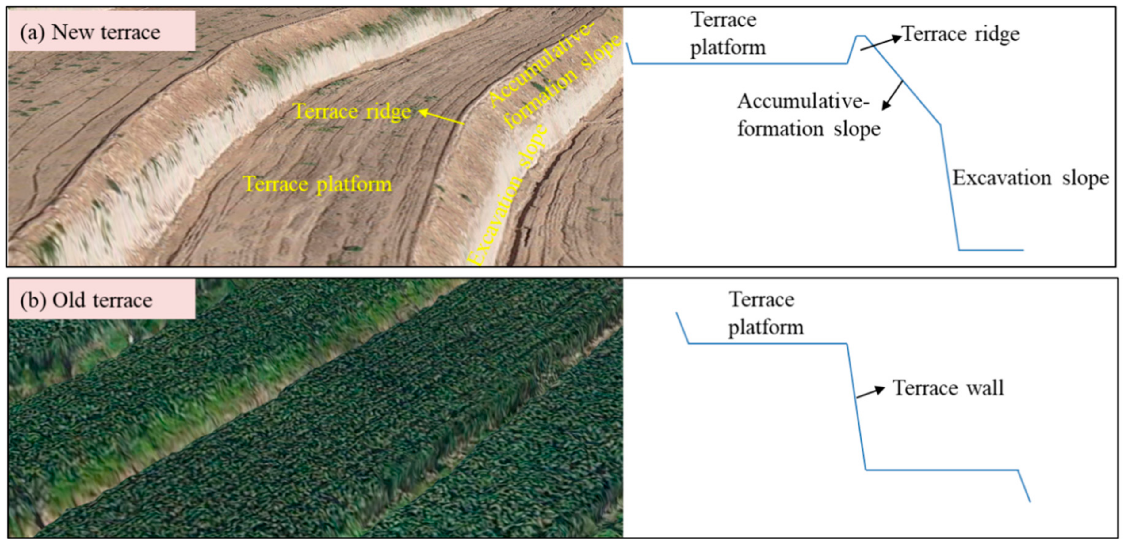
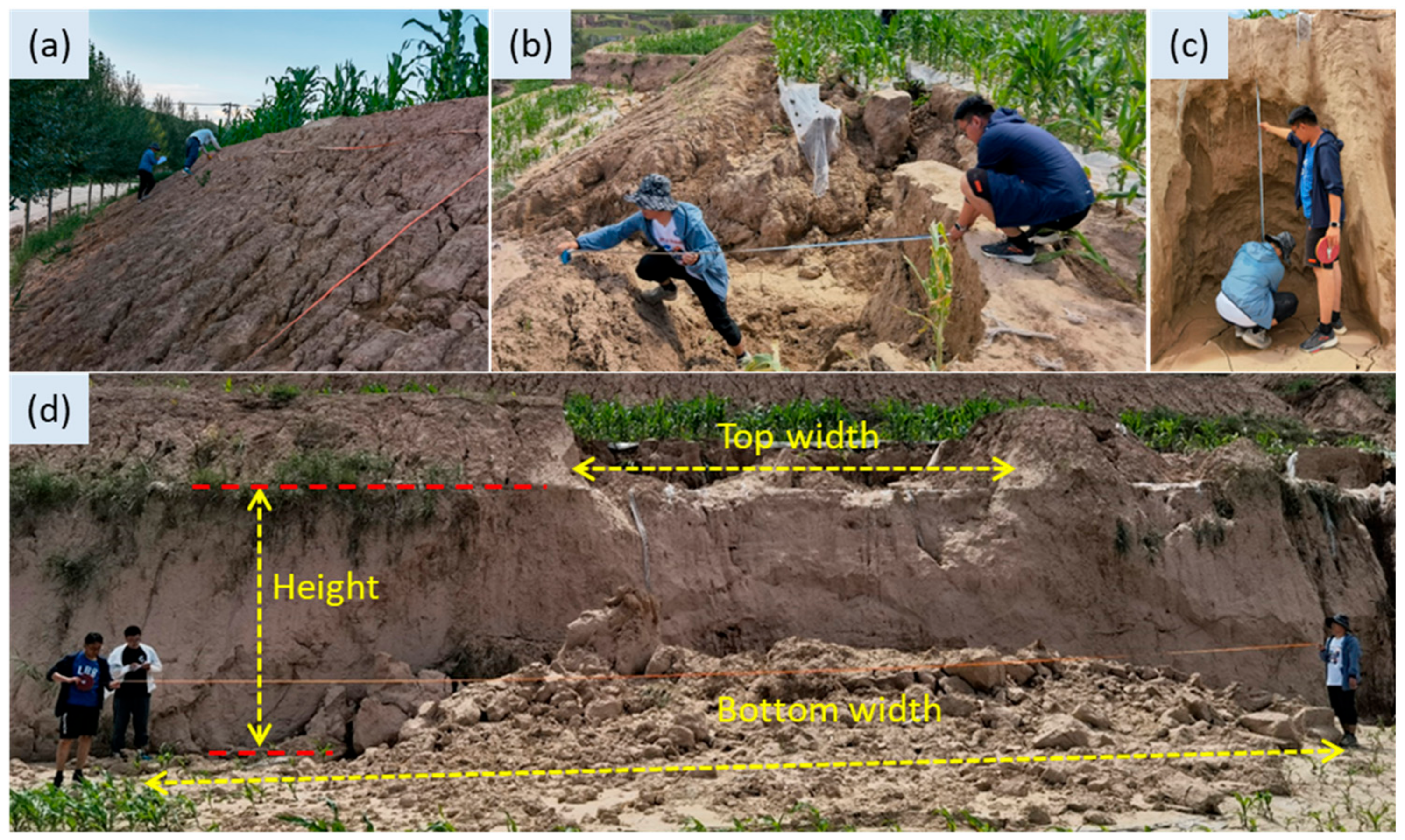
2.3. Investigation Methods

Figure 2 shows the flowchart of this study.
Firstly, drone photogrammetry was conducted to obtain the orthophotos of each watershed. The image interpretation was primarily used to determine the distribution of terraced fields in the 5 watersheds, recognize the new and old terraces, and analyze their areas and area proportions. As shown in Table 1, the areas of the terraced fields in each small watershed ranged from 0.49 to 2.04 km2, accounting for 48.9% to 85.1% of the watershed area.
The manual field survey was conducted to investigate soil erosion types, erosion morphology, and erosion amounts of the terraces. Six sample areas, including 3 with new terraces and 3 with old terraces, were randomly selected in each watershed. In particular, 4 sample areas with old terraces were selected in the Hainanwan watershed since there were no new terraces in the watershed. Figure 3 shows the structures of the new and old terraces. The new terrace has a platform, ridge, and composite wall with a bare accumulative-formation slope and excavation slope, whereas the old terrace has a terrace platform and a single wall covered by grass (Artemisia gmelinii Weber ex Stechm. Agropyron cristatum (L.) Gaertn.) without a ridge. For each sample area, 3 sample plots (each plot includes a terrace platform and a terrace wall with or without a ridge) were selected at the top, middle, and bottom of the terraced slope for field investigation. A total of 84 sample plots from the 28 sample areas (Figure 1c) of the terraced field were chosen, with 36 sample plots of new terraces and 48 plots of old terraces. For each sample plot, the width and length of the terrace platform, the slope gradient, and the height of the terrace wall, as well as the soil bulk densities of different structural units of each sample plot, were measured. Moreover, terrace conditions such as crop planting and management, for instance, plastic film mulching, were recorded.

2.4. Eroison Types Recognition and Morphology Measurements

We interviewed locals in the study area and managers of the terrace fields, and be aware that both the new and old terraces suffered very slight erosion before the heavy rainfall. Most of the terraces are being used for agricultural production (green corn) and are under good management. Especially, the new terraces exhibited good effectiveness in water and soil conservation under ordinary rainfall. Therefore, we could conclude that the obvious erosion features on the terraces were mainly triggered by this heavy rainfall.
Rills, gullies, scour holes, collapses, sink holes, and shallow landslides widely occurred on the terraces in the study area. Rills are defined as small, intermittent watercourses with steep sides caused by overland flow. Rills often have a width and depth of <20 cm and are always parallel or dendritic on a slope [26]. Gullies, including ephemeral and permanent gullies, are incised erosion features caused by concentrated flow, with sidewalls and/or head scarps on average > 0.2 m deep and a cross-sectional area of > 929 cm2 (1 ft2) [27]. Ephemeral gullies can generally be removed but permanent gullies can’t be removed by conventional tillage methods [28]. Scour holes are erosive features, also named “regressive alcoves”, on drop walls caused by drop water from upstream areas [29,30]. Collapse refers to the soil body falling down suddenly because of pressure or having no strength or support, and the collapsed block is fully separated from a steep sloped face [31]. Sink holes are surface depressions caused by the collapse of underground openings or voids created due to underground piping or tunneling [32]. Shallow landslides refer to soils slipping down as a whole along a weak belt and generally have dimensions of less than 2.0 m deep and volumes ranging from a few to several hundred cubic meters in widespread steep hillslopes [33].
For each sample plot, the erosion types were first identified, and their positions and numbers of the erosion spots were then recorded. The erosion morphology of each eroded spot was measured with a steel ruler and tape measure for each erosion type (Figure 4). Morphological indicators to be measured and the volumetric formula for each eroded spot were determined according to the shape of the spot. For example, the shapes of representative cross-sections of rills or gullies (“V” or “U”) should be recognized first, and then we determined whether the bottom width should be measured and used proper formulas to calculate their volumes. Additionally, cross-sections always vary along a gully, and the width, depth, and volume of a gully were segmentally measured and calculated. Rills were measured in three evenly distributed quadrats on the terrace platform or wall. The eroded spots of other types of erosion features on each sample plot were measured one by one, and we then calculated the total volume of each type of erosion. The heights, widths, and depths of scour holes were measured, where the height represents the height of the upper boundary of scour hole (Figure 4c). For collapse or landslide, its width and height were measured as shown in Figure 4d. The length and width of the mouth of scour hole and the depth of scour hole were measured regardless of undetectable erosion underground.

2.5. Data Analysis

For each erosion type on the new or old terraces, its soil erosion modulus can be calculated as follows:
E ( i ) = j = 1 j = n ( V ( i ) j × ρ s ) / j = 1 j = n A j
where E(i) is the erosion modulus of the ith erosion type, t km−2; V(i)j is the erosion volume of the ith erosion type on the jth strip of terraced field, m3; ρs is the soil bulk density of the terraces, which was set to 1.2 × 10³ kg/m3 [3]; n is the total number of strips of investigated new or old terraces. Aj is the area of the jth strip of terraced field, m2.
The soil erosion modulus in the study area can be calculated as follows:
E = i = 1 i = m E ( i )
E a v e r . = E N e w × p N e w + E O l d × p O l d
where E is the erosion modulus of the new or old terraces, t/km2; m is the number of erosion types; Eaver. is the average erosion modulus in the study area, t/km2; ENew and EOld represent the erosion modulus of the new and old terraces; pNew and pOld are the area proportions of the new and old terraces in the Tangjiahe Basin, %.

3. Results

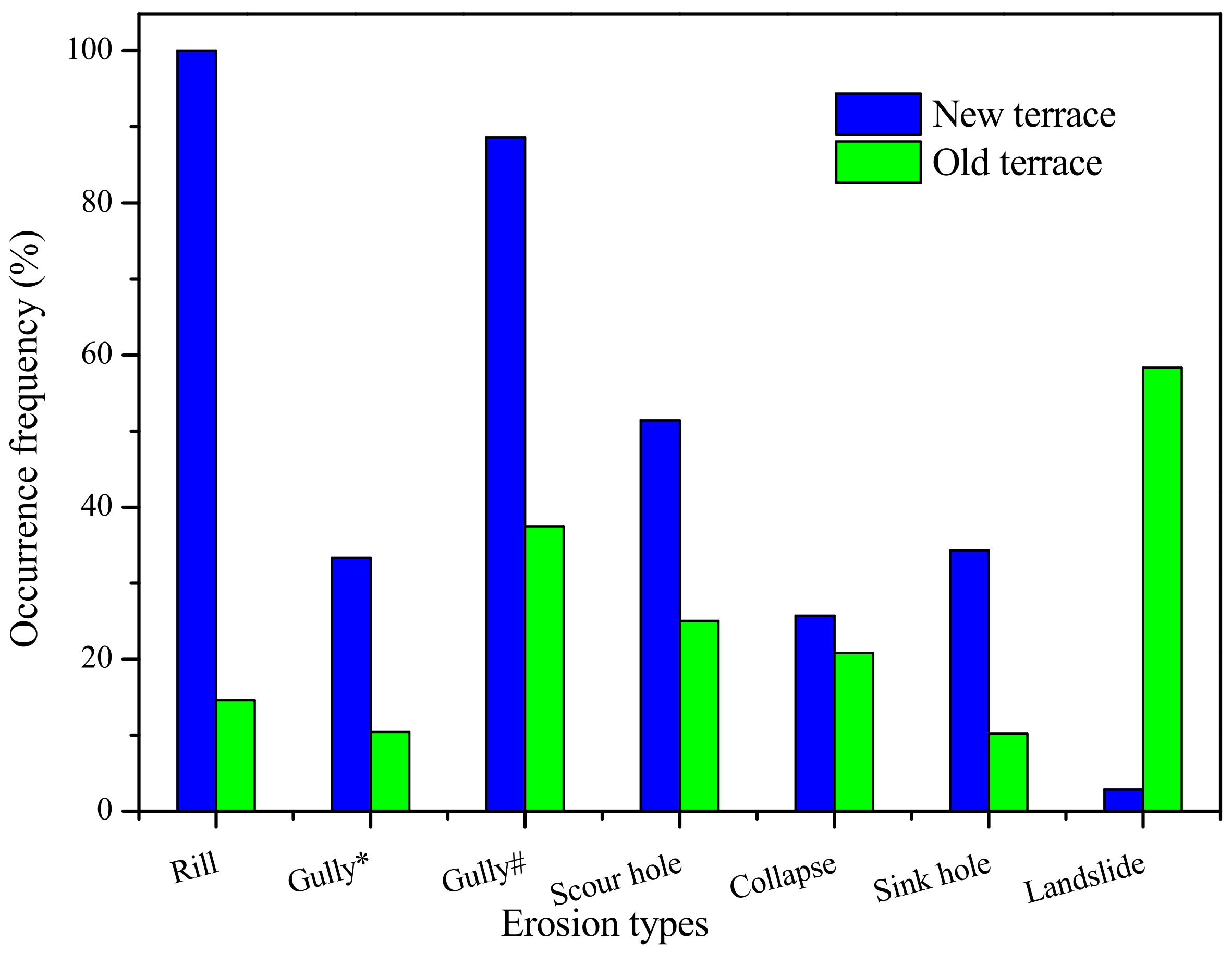
3.1. Terrace Erosion Types and Occurrence Frequencies

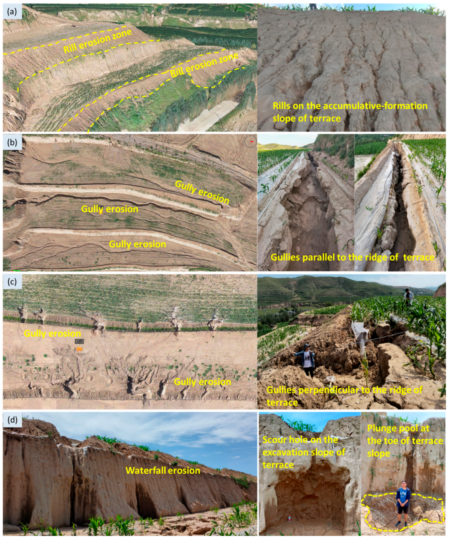
3.1.1. Water Erosion

Figure 5 shows the observed typical water erosion types on the terrace. Water erosion, such as rill, gully, and scour hole, occurred widely. Rill erosion was widely distributed on the accumulative-formation slopes of the new terraces (Figure 5a), and each new terrace field had a rill erosion zone with dense rills (Figure 6), but rills distributed sporadically on the excavation slopes of the new terraces and could be ignored. Moreover, only a few rills were found on the old terraces, with an occurrence frequency of 14.6%. Gully erosion occurred on the terrace platform with the gullies approximately parallel to the terrace ridge (Figure 5b) or on the terrace platform and slope with the gullies approximately perpendicular to the terrace ridge (Figure 5c). The former gullies had an occurrence frequency of 33.3% and 10.4% on the new terrace and old terrace, respectively, while the latter had a higher occurrence frequency of 88.6% and 37.5% (Figure 6). The gullies had an occurrence frequency on the new terrace 2–3 times higher than that on the old terraces. Waterfall erosion occurred on the old terrace slopes or the new excavation slopes. On the new terrace, waterfall erosion was generally connected to the gullies approximately perpendicular to the terrace ridge, forming flutes (vertically elongated grooves, generally tapering towards the top that furrows into the terrace wall) or scour holes on the terrace slope and plunge pools at the toe of the terrace slope (Figure 5d). The scour hole had an occurrence frequency of 51.4% on the new terrace, which was 2 times higher than that (25.0%) on the old terrace (Figure 6). The plunge pools were commonly inconspicuous due to sediment deposition.

3.1.2. Gravity Erosion

Figure 7 shows the gravity erosion types on the terraces. Collapse, sink hole, and landslide were observed in the study area. Collapse occurred on the terrace slope and had a greater occurrence frequency of 25.7% on the new terraces than on the old terraces (20.8%) (Figure 6). The large-scale collapse not only destroyed the terrace wall but also crushed and buried the crop and platform area of the lower stripe of the terrace (Figure 7a). Sink hole occurred on the terrace platform (Figure 7b), observed near the terrace ridge, on the middle platform, or near the toe of the terrace slope. The single sink hole was more common than multiple beaded sink holes. The sink hole had a higher occurrence frequency of 34.3% on the new terrace, which was 3 times that (10.2%) on the old terrace (Figure 6). The landslide occurred on the terrace walls, especially on the steep slopes covered by grass of old terraces as the shallow landslide (Figure 7c). The shallow landslide had an occurrence frequency of 58.3% on the old terraces. Only one landslide was found on a new terrace with a great height of more than 15 m and a big mass of accumulative soil on the terrace slope.

3.2. Terrace Erosion Morphology

3.2.1. Water Erosion Morphology

The morphological indicators of the rills, gullies, and scour holes are shown in Figure 8.
The rills on the accumulative-formation slope of the new terraces had a length, width, depth, and density varying from 1.4–9.3 m, 0.04–0.14 m, 0.03–0.18 m, and 1.5–3.1 number/m, with averages of 4.2 m, 0.09 m, 0.10 m, and 2.16/m, respectively (Figure 8a). The average length, width, depth, and density of rills on the new terraces were 4.3, 1.3, 1.9, and 19.1 times those on the old terraces, respectively.
The gullies approximately parallel to the terrace ridge on the new terraces had a length, width, and depth ranging from 1.0–90.0 m, 0.2–5.1 m, and 0.2–2.5 m, respectively. There were some wide and shallow gullies distributed on the platform of the new terraces. The average length, width, and depth of the gullies on the new terraces were 16.7 m, 1.4 m, and 0.4 m and were 6.2, 2.1, and 1.3 times those of the same type of gullies on the old terraces, respectively. The gullies perpendicular to the terrace ridge had an average length, width, and depth of 4.1 m, 1.4 m, and 0.8 m, respectively, which was 51.4%, 30.2%, and 21.6% greater than those of the same type of gullies on the old terraces. Furthermore, the gullies parallel to the terrace ridge had a much greater length, similar width, and lower depth compared with those of the gullies perpendicular to the terrace ridge on the new terraces. The lengths of the two types of gullies varied in large varieties and had lots of outliers in the box plots. This indicates that some gullies developed to a very large size; for instance, some gullies developed through or nearly through the whole terraces in the width or length directions of the terraces.
The scour hole on the new terraces had a height, width, and depth varying from 0.5–6.9 m, 0.5–3.0 m, and 0.3–2.3 m with averages of 2.9 m, 1.3 m, and 1.0 m, respectively. The scour hole on the old terraces had a smaller size, with the average height, width, and depth being 25.7%, 10.7%, and 33.1% lower than those on the new terraces.

3.2.2. Gravity Erosion Morphology

The morphological indicators of the collapses, sink holes, and landslides are shown in Figure 9. The collapses that occurred on the new terraces had a width, height, and thickness ranging from 0.5–17.4 m, 0.1–5.2 m, and 0.1–3.1 m, with averages of 4.8 m, 0.8 m, and 0.9 m, respectively. The collapses on the old terraces had a greater width with a maximum of 21.9 m and an average of 8.6 m, and a lower height and thickness with reductions by 23.0% and 29.5% of the averages compared with those on the new terraces. The sink holes were shaped like ellipses and had lengths, widths, and depths varying from 0.5–8.1 m, 0.5–4.0 m, and 0.3–4.1 m, with averages of 0.8 m, 1.6 m, and 1.2 m on the new terraces, respectively. The average length, width, and depth of the sink holes on the old terraces were 65.1%, 54.1%, and 20.7% lower than those on the new terraces. In terms of the landslide, the width, height, and thickness of the shallow landslides on the old terraces were in the ranges of 0.9–5.8 m, 1.7–3.5 m, and 0.1–0.4 m, with averages of 2.8 m, 2.4 m, and 0.2 m, respectively. The only landslide found on the new terrace had a much greater size, with a 5.3 m width, 19.1 m height, and 1.2 m thickness.

3.3. Erosion Modulus and Proportions of Each Erosion Type

3.3.1. The Erosion Modulus

Figure 10 shows the soil erosion moduli of different types of erosion on the new and old terraces. On the new terraces, the rill, gully, scour hole erosion, collapse, sink hole, and landslide had moduli of 2303 t/km2, 26,621 t/km2, and 3179 t/km2, 3684 t/km2, 1556 t/km2, and 1910 t/km2, respectively. The gullies approximately perpendicular to the terrace ridge had the greatest modulus (17,493 t/km2), which was 91.7% greater than the gullies approximately parallel to the terrace ridge. Moreover, the modulus of the water erosion (32,102 t/km2) was 4.5 times that of the gravity erosion.
On the old terraces, only a few rills were found; the rill erosion volume on the old terraces was low and unnoticeable. The erosion moduli of the gully, scour hole, collapse, sink hole, and landslide were 6513 t/km2, 1173 t/km2, and 5601 t/km2, 709 t/km2, and 2494 t/km2, respectively. The gullies approximately perpendicular to the terrace ridge had the greatest modulus (6375 t/km2), while the gullies approximately parallel to the terrace ridge had the lowest erosion modulus (the rill erosion can be ignored). Moreover, the modulus of the gravity erosion (8804 t/km2) was 14.5% greater than that of the water erosion. Furthermore, the gully, scour hole erosion, and sink hole on the new terraces had a greater erosion modulus than those on the old terraces, with increases of 171.0%, 119.5%, and 308.7%, respectively. Lower moduli of the collapse and landslide were found on the new terraces compared with those on the old terraces, with reductions of 34.2% and 23.4%.

3.3.2. The Erosion Proportions

Figure 11 shows the soil erosion proportions for each erosion type. On the new terraces, the gully erosion dominated the terrace erosion with a proportion of 67.8%, in which the erosion from the gullies approximately perpendicular to the terrace ridge had the greatest proportion of 44.6%. The rill erosion, collapse, and scour hole erosion had a proportion of less than 10% but greater than 5%, while the sink hole erosion and landslide had an erosion proportion of less than 5%. The contribution of the water erosion to the terrace erosion was 81.8%, and the water erosion dominated the terrace erosion on the new terraces.
On the old terraces, the erosion from the gullies, approximately perpendicular to the terrace ridge, dominated the terrace erosion with a proportion of 38.7%. In particular, the collapse had a similar contribution as the gully erosion to the terrace erosion, with a proportion of 34.0%. The landslide had a non-negligible contribution of more than 15% proportion. The sink hole erosion had a low proportion of 4.3%, and the contribution of the erosion from the gullies approximately parallel to the terrace ridge can be ignored. Overall, the contribution of gravity erosion to terrace erosion was 53.4%, and gravity and water erosion had a similar contribution to the terrace erosion on the old terraces.

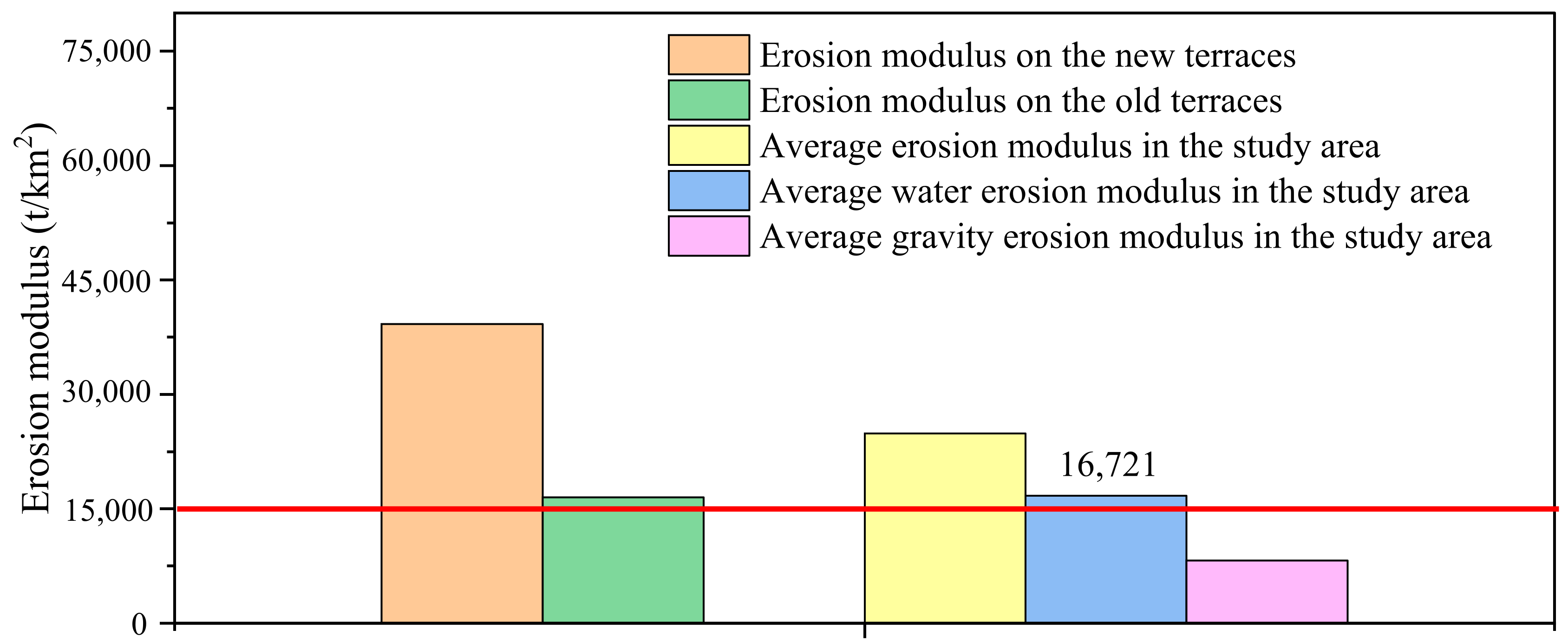
3.3.3. Erosion Moduli on the New and Old Terraces

Figure 12 shows the erosion moduli on different terraces and the average erosion modulus in the study area. The erosion modulus on the new terraces was 39,252 t/km2 and was 2.4 times that on the old terraces (16,491 t/km2). Moreover, the average erosion modulus of the study area was calculated to be 24,867 t/km2. Additionally, the average water and gravity erosion moduli in the study area were 16,721 and 8192 t/km2, respectively. Based on the grading standard of water erosion intensity, when the water erosion modulus is greater than 15,000 t/km2/a, severe water erosion is recognized. Therefore, the water erosion in the study area reached a “severe” intensity.

4. Discussion

4.1. Terrace Erosion under Heavy Rainfalls

In this study, rills, gullies, scour holes, collapses, sink holes, and landslides were widely found on the terraces, indicating that both water and gravity erosion were common, and the erosion on the terrace under heavy rainfalls was complicated and varied. Similar results were reported by previous studies conducted in different regions (Table 2). The erosion types might be mainly determined by heavy rainfall, topography, soil properties, and land cover conditions. Rills mainly developed on the bare and loose accumulative-formation slopes of terrace walls (Figure 5a), and the frequency of rill erosion was high to 100% on the new terraces. Rills are initiated when the shear stress of overland flow exceeds the critical shear stress of the soils, which depends on soil properties [26]. Rill erosion can be well controlled by terracing of the cultivated agricultural slopes [1] but could still be severe on a terrace under heavy rainfalls, especially on mechanical terraces with bare and loose walls, ridges, and platforms, exhibiting a considerable rill erosion modulus (2303 t/km2 in our study). Rills on the accumulative-formation slopes might not develop into a gully because of the limited catchment area on the terrace wall. Very few rills were found on the terrace platform because of plastic film mulching, and once the concentrated flow broke the film, a gully could rapidly develop on the terrace platform. Gully erosion was widely reported on the terraced fields under extreme rainfalls (Table 2). We defined two different types of gullies approximately parallel and perpendicular to the terrace ridge (Figure 5b,c). Those developed gullies were related to the improper terrace design that caused runoff concentration along terrace ridges and the uncontrolled release of concentrated flow over-topping of terraces at low spots or breaking the terrace ridge to the next step of the terrace [12]. Terrace-produced runoff under heavy rainfalls might concentrate in the lowest spots of the uneven terrace platform without drainage measures, resulting in a mass of rainwater ponding behind the terrace ridge and eventually incising the terrace ridge to initiate gully erosion [1]. The processes continued on the next step of the terrace and might be strengthened from the upper terrace to the lower terrace because of the increasing catchment area [23]. Moreover, gullies may develop as a consequence of overland flow concentration in the spots where the terrace wall collapsed [1]. We further found and defined an erosion type, scour holes, connecting the gullies approximately perpendicular to the terrace ridge, only occurring on the steep terrace walls (Figure 5d). Scour hole erosion on the terrace wall is driven by waterfalls (Figure 5d). The terrace riser (wall) is converted into an artificially vertical drop where the concentrated flow from the platform drops freely to form a waterfall. The waterfall scours the terrace wall to form a scour hole or flute on the wall, driven by on-wall and jet flow [30], which further destabilizes terrace walls. Gravity erosion in the study area included collapse, sink hole, and shallow landslide. Extreme rainfall may result in soil saturation and flow scouring of terrace walls, promoting terrace failure. Infiltration-induced saturation under heavy rainfalls reduced soil cohesion and increased the weight of retained soil materials, contributing to the reduction of the stability of terrace walls [1,21]. Terrace wall collapse commonly occurs in terraced fields, induced by soil strength weakening due to infiltration and steep slopes, as well as high walls [21,35]. Sink holes were distributed on the terrace platforms (Figure 6). Sink holes developed when the hanging soil body sank induced by piping and/or tunneling, which was mainly caused by the lack of soil structure and the dispersive character of the soil material on terraces [14,36]. The concentrated flow could be ponded at a lower spot on the terrace platform and might infiltrate and erode underground soil as preferential flow if the soil body of the terrace was loose with voids and cavities in it [37]. Piping and/or tunneling occurred as a consequence, and finally sink hole developed. The shallow landslide occurred on the vegetation-covered terrace walls in our study (Figure 7c), which is very different in scale from that occurred on the hillslopes with terraces reported by Agnoletti et al. [38]. Shallow landslide commonly occurs on steep vegetation-covered slopes as a saturated root-soil layer triggered by rainstorms, and vegetation might exhibit a promoting effect in its initiation [33]. Shallow landslides frequently occurred on the old terrace walls covered by grasses (Figure 6), indicating that vegetation cover reduced rill and gully erosion but might not be a sufficient measure to protect terrace walls under heavy rainfalls.
In our study, the occurrence frequencies, morphology indicators, and erosion moduli of the rill, gully, and scour hole were much greater on the new terraces than on the old terraces. On the old terraces, rill, gully, and scour erosion risks can be dramatically reduced because of the artificially meticulous construction, sufficient settlement, grass coverage of the terrace wall, and small catchment area of each step of the terraces. However, the new terraces had bare and loose soil and large catchment areas that made terrace-produced runoff more concentrated and dramatically strengthened runoff scouring. The concentrated flow on the steep, bare risers promotes gully erosion and can increase soil loss exponentially [39]. The length, modulus, and proportion of collapse were greater on the old terrace than on the new terrace in our study. This might be related to the rapid infiltration and saturation of the grass-covered wall, as well as the nearly vertical slope of the old terrace wall. Sink holes had a much greater frequency and modulus on the new terrace than those on the old terrace because the new terraces had a poorer soil structure than the old terraces. Our results further showed that the modulus of the water erosion (32,102 t/km2) was 4.5 times that of the gravity erosion on the new terraces, whereas the modulus of the gravity erosion (8804 t/km2) was 14.5% greater than that of the water erosion on the old terraces. The result on the new terraces was very different from that reported by Han et al. [22], who found that the modulus of gravity erosion in terrace land (8397 t/km2) was much greater than that of water erosion (rill/gully erosion). This is related to the following factors. The terraces investigated by Han et al. [22] had vegetation coverage of > 25%, and the water erosion was restricted because of the erosion resistance of the root-soil matrix of the terrace to concentrated flow [40]. Additionally, drainage measures and bio-embankment were applied in some terraces, which further controlled rill/gully erosion, and this is why a lower water erosion modulus was observed in Han et al. [22]. However, vegetation and other measures such as drainage channels might play limited roles in maintaining the stability of the terrace under heavy rainfall [38], and therefore a similar gravity erosion modulus was observed in our study on the old terraces. Lack of drainage measures, plastic film mulching, as well as loose and bare terrace ridges and walls on the new terraces, might be responsible for the very high water erosion modulus on the new terrace in our study, which will be discussed in detail in the following text. The erosion modulus on the new terraces (39,252 t/km2) was 2.4 times that on the old terraces (16,491 t/km2), which was supported by Yang et al. [4]. However, Guo et al. [3] and Chen et al. [16] reported opposite conclusions, stating that the erosion modulus of the old terraces was much greater than that of the new terraces (Table 2). The lack of management and vegetation measures of the old terraces in their study areas might be responsible for the very high erosion modulus [3]. Moreover, gully erosion dominated terrace erosion on the new terrace, with a proportion of 67.8%, whereas gully erosion and collapse dominated the old terrace, with proportions of 38.7% and 34.0%, respectively. Those results were supported by previous studies [4,16,22]. The results reveal the key erosion processes that should be specifically prevented during heavy rainfalls.

4.2. Factors Promoting Terrace Erosion under Heavy Rainfalls

4.2.1. Plastic Film Mulching

Plastic film mulching is extensively used to conserve moisture, enhance water and nutrient supply efficiency, and increase crop yields [41]. In the study area, most of the terraced fields were used for planting green corn with plastic film mulching (Figure 13a). 84.5% of the sample plots had been mulched with plastic film on the terrace platform. The breadth of each line of the mulching plastic film varied in a range of 0.7–0.8 m, and the distance between the two adjacent lines of the film was less than 0.2 m (Figure 13b). The two adjacent sides of the two pieces of plastic film were buried under compacted soils to stabilize the plastic film; therefore, the limited area between the two adjacent lines of the plastic film also had plastic film mulching under the soil surface. However, full plastic film mulching on terrace fields drastically reduces rainfall infiltration into the soil due to the impermeability of the plastic film [42]. Especially under heavy rainfalls, fully film mulched terrace fields experience rapid, high-intensity surface runoff, which easily forms stormflow, posing significant erosion potential on both terrace surfaces and risers [22]. Although the plastic film mulching dramatically reduced rainfall splash and rill erosion on the terrace platform, the stormflow could break through the film or down-cut into the soil between two adjacent pieces of the film and induce very severe gully erosion (Figure 5b, Figure 13a).

4.2.2. Loose and Bare Terrace Ridges and Walls

Excavation of the original slope and accumulation of the excavated soil are primarily employed for the construction of the terrace platform, ridge, and wall (Figure 14) [1]. Excavation preserves the original soil structure and compaction of the cut slope and the partial platform. However, the accumulation area, including the terrace ridge, partial platform, and wall, has loose soil due to the difficulty of compacting soil adequately near the terrace edges using heavy machinery (Figure 14). We found that the terrace ridges and the accumulative-formation slopes of the new terraces had bulk densities varying from 1.09–1.15 g cm−3 with an average of 1.11 g m−3. Moreover, the accumulative soil had a poor soil structure, failed to settle sufficiently, and even had large voids and cavities in it. Furthermore, the terrace ridge and wall were bare on the new terrace. Those make the accumulation area of the new terrace highly susceptible to water and gravity erosion under rainstorms [1,43]. Under heavy rainfalls, raindrops splashed the bare ridge and wall, and the overland runoff generated on the accumulative-formation slope induced severe rill erosion (Figure 5a). The stormflow that flowed to the inside toe of the terrace ridge soaked, saturated, and eroded the ridge soil and caused water pressure on the terrace ridge. This further weakened the erosion resistance and stability of the ridge combined with the infiltration and saturation of the rainfall [34], which promoted the destruction of certain sections of the ridge where the soil was more prone to erosion, and finally, the gullies approximately perpendicular to the terrace ridge rapidly developed (Figure 5c). Moreover, preferential flow in the large voids and cavities near the terrace ridge could cause subsurface erosion such as piping and tunneling, and the sink holes subsequently developed (Figure 7b) [37].

4.2.3. Inclined Terrace Platform and High Terrace Wall

Terraces are always constructed on steep hillslopes; thus, the terraced field surfaces are not completely level [1]. The new terrace in the study area had a platform surface with uneven height differences of less than 0.1 m at a horizontal slope not exceeding 1/100. Even so, the new terraces had a relative inclination. These inclined terraces accelerated the runoff concentration under the heavy rainstorm, which induced the development of the gullies approximately parallel to the terrace ridge (Figure 5b) [1,12]. Additionally, tall and steep terrace walls also promote the erosion of the new terrace. The new terraces had high terrace walls with heights of 2.8–4.0 m and steep walls with the gradients of the cut slopes greater than 70°. The terrace walls, which were too high on quite steep slopes, are difficult to manage and maintain [13]. The higher the terrace wall, the greater the risk of collapse [1]. Thereby, the stability of terraced walls against mass movements was reduced under higher terrace walls, and the collapse of the wall occurred frequently as a result (Figure 7a), especially under heavy rainfalls.

4.2.4. The Developing Flow and Sediment Delivery Paths

Terracing originally decreased the hydrological connectivity by increasing the infiltration of rainfall, intercepting runoff and encouraging it to infiltrate, and altering the flow path [1,7,8] for water and soil conservation purposes. However, new flow and sediment delivery paths were developing due to channel formation under heavy rainfalls, which promoted soil erosion of the terraces. There was a lack of artificial drainage channels on the terraces in the study area. Therefore, runoff concentrated at the lowest spots of each terrace platform in unpredictable paths to transform into stormflows. On the one hand, the stormflow might break the terrace ridges and flow onto the lower steps of the terraced field (Figure 15a,b). On the other hand, the stormflow might flow approximately parallel to the terrace ridge and then further concentrate onto the production roads and finally be drained through the unpaved roads with very severe gully erosion on the roads (Figure 15c,d). Generally, a combination of the above two situations was more common, forming uncontrolled channels for flood drainage and sediment transportation. The developing flow and sediment delivery paths increased the hydrological connectivity and could dramatically increase the erosion intensity of the terraces under heavy rainfalls.

5. Recommendations for Erosion Control and Terrace Management

Regional rainfall has become increasingly uneven throughout the year due to global climate change, marked by a notable rise in the frequency of heavy and extreme rainfall events in recent years [44]. It is advisable to raise the designed level of storm and other criteria appropriately for terrace construction projects to make modern terraces sustainable [1]. Terraced fields face challenges in retaining and infiltrating all surface runoff during extreme rainfall conditions, making optimization of terrace drainage essential. Therefore, enhancing the design and implementation of terrace drainage infrastructure is recommended [14]. Moreover, terrace construction techniques should be optimized to improve overall stability. For instance, during machine-based terrace construction, it is crucial to ensure a homogeneous soil structure for each layer, create a flat field surface to avoid low-lying areas, and firmly compact the terrace edges. Furthermore, agricultural techniques should be applied rationally. For example, adequate infiltration space should be provided when mulching plastic film on terrace fields to enhance rainfall infiltration rates and reduce runoff intensity. Additionally, emphasis should be placed on temporary protective measures for new terraced fields, such as the timely broadcasting of indigenous grass seeds on the slopes to promote rapid growth and establish robust grass cover on exposed terrace surfaces [14]. Initial colonization by moss and complex cover is important for the stability of terrace walls [45]. Finally, effective management and maintenance of terraces are crucial for the sustainable functioning of terraced fields [43]. Terraced fields subjected to human management exhibit minimal erosion, while those without such practices experience significant erosion and potential failure [1]. It is essential to promptly inspect and address any potential damage to terraced fields. If the terrace platform is uneven or exhibits irregular settlements, or if erosion occurs on the terraced ridges or there is a collapse of the terrace walls, appropriate measures such as soil filling, compaction, and repairs should be executed swiftly to effectively manage the risks posed by unpredictable heavy rainfall erosion.

6. Conclusions

This study investigated the characteristics of erosion in loess terraced fields subjected to heavy rainfall events. Water erosion, such as rill, gully, and scour hole erosion, and gravity erosion, such as sink hole, collapse, and shallow landslide erosion, were commonly developed. Rills and shallow landslides were the most prevalent on the new and old terraces, respectively; however, they exhibited low erosion moduli. On the new terraces, the erosion moduli of gully, scour hole, and sink hole were 171.0%, 119.5%, and 308.7% higher, whereas the erosion moduli of collapse and landslide were lower by 34.2% and 23.4%, respectively, compared to those on the old terraces. Among the various types of erosion, gully erosion demonstrated the highest modulus and proportion on the new terraces, while both gully erosion and collapse displayed similarly high moduli and proportions on the old terraces, indicating that these processes are critical to understanding erosion dynamics in loess terraces during heavy rainfall events. Water erosion was significantly more severe than gravity erosion on the new terraces. In the study area, the new terraces suffered much more severe erosion than the old terraces under heavy rainfall. The key factors promoting severe erosion of the new terraces during the heavy rainfall included the unreasonable mulching with plastic film, loose and bare ridges and walls of terrace, inclined terrace platforms and high terrace walls, as well as the developing flow and sediment delivery paths. Consequently, we recommend enhancing the standard of terrace design, optimizing construction technologies, implementing temporary protections for terrace ridges and walls, rationally utilizing agricultural techniques, and strengthening the management and maintenance of terraces for soil erosion control under heavy rainfall events.

Author Contributions

Conceptualization, H.K. and W.W.; methodology, H.K.; software, L.L.; validation, L.H.; formal analysis, H.K. and L.L.; investigation, H.K. and S.W.; resources, W.W.; data curation, S.W.; writing—original draft preparation, H.K.; writing—review and editing, W.W., L.H., L.L. and S.W.; visualization, H.K.; supervision, W.W.; project administration, W.W.; funding acquisition, H.K. and W.W. All authors have read and agreed to the published version of the manuscript.

Funding

This work was supported by the National Natural Science Foundation of China (42077079), the Natural Science Basic Research Project of Shaanxi Province (2024JC-YBQN-0295), the Opening Fund of State Key Laboratory of Soil Erosion and Dryland Farming on the Loess Plateau (F2010121002-202415), the Fundamental Research Funds for the Central Universities, CHD (300102353103), the National Key Research and Development Program of China (2023YFF1305105), and the Innovation Capability Support Program of Shaanxi (2024RS-CXTD-55).

Data Availability Statement

The data that support the findings of this study are available from the corresponding author upon reasonable request.

Acknowledgments

We greatly appreciate the careful and precise reviews by the anonymous reviewers.

Conflicts of Interest

Author Liangna Li is employed by the company Shaanxi Huadi Survey and Design Consulting Co., Ltd. The remaining authors declare that the research was conducted in the absence of any commercial or financial relationships that could be construed as a potential conflict of interest.

References

  1. Deng, C.; Zhang, G.; Liu, Y.; Nie, X.; Li, Z.; Liu, J.; Zhu, D. Advantages and disadvantages of terracing: A comprehensive review. Int. Soil Water Conserv. Res. 2021, 9, 344–359. [Google Scholar] [CrossRef]
  2. Chen, D.; Wei, W.; Chen, L. Effects of terracing practices on water erosion control in China: A meta-analysis. Earth-Sci. Rev. 2017, 173, 109–121. [Google Scholar] [CrossRef]
  3. Guo, J.; He, L.; Pei, Z.; Lv, D.; Lei, S.; Zhang, X. Investigation and Analysis of Damage of Horizontal Terraced Fields Under Extreme Rainstorm Conditions in the Loess PlateauTaking the 7·26 Torrential Rain in the Chabagou Watershed as an Example. Res. Soil Water Conserv. 2019, 26, 107–113. [Google Scholar] [CrossRef]
  4. Yang, B.; Jiao, J.; Ma, X.; Zhao, W.; Ling, Q.; Zhang, X.; Wang, F.; Han, J.; Du, P.; Cong, P.; et al. Investigation and analysis of typical rainstorm erosion and flood disaster on Loess Plateau in 2022. Bull. Soil Water Conserv. 2022, 42, 360. [Google Scholar] [CrossRef]
  5. Jia, L.; Gao, J.; Zhang, Y.; Zhang, M.; Wang, X.; Li, X. Analysis of Rainstorm Erosion Disaster in Terrace Field in Loess Hilly and Gully Region. Res. Soil Water Conserv. 2014, 21, 7–11. [Google Scholar] [CrossRef]
  6. Stavi, I.; Eldad, S.; Xu, C.; Xu, Z.; Gusarov, Y.; Haiman, M.; Argaman, E. Ancient agricultural terrace walls control floods and regulate the distribution of Asphodelus ramosus geophytes in the Israeli arid Negev. Catena 2024, 234, 107588. [Google Scholar] [CrossRef]
  7. Schilling, K.E.; Jacobson, P.J. Water and nutrient discharge to a high-value terrace-flood plain fen: Resilience and risk. Ecohydrology 2016, 9, 1196–1207. [Google Scholar] [CrossRef]
  8. Gibson, B.J.; Koch, Z.G.; Compson, B.A.; Hungate, J.C. Ecosystem responses to restored flow in a travertine river. Freshw. Sci. 2018, 37, 169–177. [Google Scholar] [CrossRef]
  9. Jiao, J.; Wang, W.; Li, J. Analysis on Soil and Water Conservation Benefits of Level Terrace Under Different Rainfall Condition in Loess Hilly Region. J. Soil Eros. Soil Water Conserv. 1999, 5, 59–63. [Google Scholar] [CrossRef]
  10. Ma, Y.; Zhang, D.; Pan, C.; Jiang, Y. Effects of terrace on the precipitation-runoff process in the Chinese loess areas and application and improvement of SCS-CN model. Trans. Chin. Soc. Agric. Eng. 2022, 38, 85–91. [Google Scholar] [CrossRef]
  11. Wei, W.; Chen, D.; Wang, L.; Daryanto, S.; Chen, L.; Yu, Y.; Lu, Y.; Sun, G.; Feng, T. Global synthesis of the classifications, distributions, benefits and issues of terracing. Earth-Sci. Rev. 2016, 159, 388–403. [Google Scholar] [CrossRef]
  12. Wen, Y.; Kasielke, T.; Li, H.; Zhang, B.; Zepp, H. May agricultural terraces induce gully erosion? A case study from the Black Soil Region of Northeast China. Sci. Total Environ. 2021, 750, 141715. [Google Scholar] [CrossRef] [PubMed]
  13. Ramos, M.C.; Cots-Folch, R.; Martínez-Casasnovas, J.A. Sustainability of modern land terracing for vineyard plantation in a Mediterranean mountain environment—The case of the Priorat region (NE Spain). Geomorphology 2007, 86, 1–11. [Google Scholar] [CrossRef]
  14. Lesschen, J.P.; Cammeraat, L.H.; Nieman, T. Erosion and terrace failure due to agricultural land abandonment in a semi-arid environment. Earth Surf. Process. Landf. 2008, 33, 1574–1584. [Google Scholar] [CrossRef]
  15. Cammeraat, E.L.H. Scale dependent thresholds in hydrological and erosion response of a semi-arid catchment in southeast Spain. Agric. Ecosyst. Environ. 2004, 104, 317–332. [Google Scholar] [CrossRef]
  16. Chen, Y.; Vanmaercke, M.; Jiao, J.; Bai, L.; Tang, B.; Wang, N.; Zhang, Y.; Wang, H. Quantifying the importance of different erosion processes and soil and water conservation measure collapses following an extreme rainstorm in the Chinese Loess Plateau. Land Degrad. Dev. 2022, 34, 403–422. [Google Scholar] [CrossRef]
  17. Lin, Z.; Liu, B.; Cong, P.; Jiao, J.; Wang, C.; Dang, W.; Xing, X. Soil and water conservation survey after a heavy storm on 10th August, 2019 in Linqu, Shandong Province. J. Soil Water Conserv. 2021, 35, 149–153. [Google Scholar] [CrossRef]
  18. Duan, J.; Liu, Y.J.; Tang, C.J.; Shi, Z.H.; Yang, J. Efficacy of orchard terrace measures to minimize water erosion caused by extreme rainfall in the hilly region of China: Long-term continuous in situ observations. J Env. Manag. 2021, 278, 111537. [Google Scholar] [CrossRef]
  19. Andrea, C.; Pierluigi, B.; Claudia, S.; Ivano, R. Relationships between geo-hydrological processes induced by heavy rainfall and land-use: The case of 25 October 2011 in the Vernazza catchment (Cinque Terre, NW Italy). J. Maps 2013, 9, 289–298. [Google Scholar] [CrossRef]
  20. Okajima, K.; Nishiwaki, S. The tendency of damage of stone walls in terrace fields in the northwestern Kumamoto City by the 2016 Kumamoto Earthquake and heavy rain in 2016 and 2006. Paddy Water Environ. 2019, 17, 231–236. [Google Scholar] [CrossRef]
  21. Moreno-de-las-Heras, M.; Lindenberger, F.; Latron, J.; Lana-Renault, N.; Llorens, P.; Arnáez, J.; Romero-Díaz, A.; Gallart, F. Hydro-geomorphological consequences of the abandonment of agricultural terraces in the Mediterranean region: Key controlling factors and landscape stability patterns. Geomorphology 2019, 333, 73–91. [Google Scholar] [CrossRef]
  22. Han, J.; Ge, W.; Hei, Z.; Cong, C.; Ma, C.; Xie, M.; Liu, B.; Feng, W.; Wang, F.; Jiao, J. Agricultural land use and management weaken the soil erosion induced by extreme rainstorms. Agric. Ecosyst. Environ. 2020, 301. [Google Scholar] [CrossRef]
  23. Li, H.; Gao, J.e.; Zhang, Y.; Bai, X.; Ssun, P.; Zhang, Y. Analysis of Yanan Extreme Rainfall Characteristics and Impacts of Erosion Disasters on Terraces. J. Soil Water Conserv. 2016, 30, 79–84. [Google Scholar] [CrossRef]
  24. Yan, S.; Li, B.; Yu, K.; Cong, P.; Dai, N. Investigation on erosion intensity of production roads under “7·13” rainstorm in 2020. Bull. Soil Water Conserv. 2022, 42, 14–22. [Google Scholar]
  25. Gao, J.; Dang, W.; Zhou, Z.; Li, X. Investigation and consideration of gravity erosion during July 15, 2022 rainstorm in Xiji County. Yellow River 2024, 46, 109–112. [Google Scholar] [CrossRef]
  26. Ou, X.; Hu, Y.; Li, X.; Guo, S.; Liu, B. Advancements and challenges in rill formation, morphology, measurement and modeling. Catena 2021, 196. [Google Scholar] [CrossRef]
  27. Poesen, J.; Nachtergaele, J.; Verstraeten, J.; Valentin, C. Gully erosion and environmental change: Importance and research needs. Catena 2003, 50, 91–133. [Google Scholar] [CrossRef]
  28. Thwaites, R.N.; Brooks, A.P.; Pietsch, T.J.; Spencer, J.R. What type of gully is that? The need for a classification of gullies. Earth Surf. Process. Landf. 2021, 47, 109–128. [Google Scholar] [CrossRef]
  29. de Oliveira, M.A.T. ‘Adhesion Flow’ and Regressive Gully-Head Expansion in Southern Brazil: Field Experiment Results. In Soil Erosion Research for the 21st Century, Proceedings of the IEEE International Symposium, Honolulu, HI, USA, 3–5 January 2001; Ascough, J.C., II, Flanagan, D.C., Eds.; American Society of Agricultural and Biological Engineers: St. Joseph, MI, USA, 2001. [Google Scholar]
  30. Kang, H.; Wang, W.; Guo, M.; Li, J.; Chen, Z.; Lou, Y.; Guo, W.; Xiao, H. Headwall scour hole erosion and overhanging mass collapse play critical roles in gully head retreat on grassland under surface flow. Geomorphology 2022, 411, 108301. [Google Scholar] [CrossRef]
  31. Xu, X.Z.; Liu, Z.Y.; Wang, W.L.; Zhang, H.W.; Yan, Q.; Zhao, C.; Guo, W.Z. Which is more hazardous: Avalanche, landslide, or mudslide? Nat. Hazards 2015, 76, 1939–1945. [Google Scholar] [CrossRef]
  32. Dave, M.; Juneja, A. Sinkholes: Trigger, Development, and Subsidence—A Review; Springer Nature: Singapore, 2023; pp. 289–296. [Google Scholar]
  33. Guo, W.-Z.; Chen, Z.-X.; Wang, W.-L.; Gao, W.-W.; Guo, M.-M.; Kang, H.-L.; Li, P.-F.; Wang, W.-X.; Zhao, M. Telling a different story: The promote role of vegetation in the initiation of shallow landslides during rainfall on the Chinese Loess Plateau. Geomorphology 2020, 350, 106879. [Google Scholar] [CrossRef]
  34. SL 190-2007; Standards for Classification and Gradation of Soil Erosion. Ministry of Water Resources of the People’s Republic of China: Beijing, China, 2008.
  35. Lasanta, T.; Arnáez, J.; Oserín, M.; Ortigosa, L.M. Marginal Lands and Erosion in Terraced Fields in the Mediterranean Mountains. Mt. Res. Dev. 2001, 21, 69–76. [Google Scholar] [CrossRef]
  36. Díaz, A.R.; Sanleandro, P.M.; Soriano, A.S.; Serrato, F.B.; Faulkner, H. The causes of piping in a set of abandoned agricultural terraces in southeast Spain. Catena 2007, 69, 282–293. [Google Scholar] [CrossRef]
  37. Zhang, Y.; Zhang, Z.; Ma, Z.; Chen, J.; Akbar, J.; Zhang, S.; Che, C.; Zhang, M.; Cerdà, A.; Lupwayi, N. A review of preferential water flow in soil science. Can. J. Soil Sci. 2018, 98, 604–618. [Google Scholar] [CrossRef]
  38. Agnoletti, M.; Errico, A.; Santoro, A.; Dani, A.; Preti, F. Terraced Landscapes and Hydrogeological Risk. Effects of Land Abandonment in Cinque Terre (Italy) during Severe Rainfall Events. Sustainability 2019, 11, 235. [Google Scholar] [CrossRef]
  39. Verheijen, F.G.A.; Jones, R.J.A.; Rickson, R.J.; Smith, C.J. Tolerable versus actual soil erosion rates in Europe. Earth-Sci. Rev. 2009, 94, 23–38. [Google Scholar] [CrossRef]
  40. Knapen, A.; Poesen, J.; Govers, G.; Gyssels, G.; Nachtergaele, J. Resistance of soils to concentrated flow erosion: A review. Earth-Sci. Rev. 2007, 80, 75–109. [Google Scholar] [CrossRef]
  41. Zhang, L.; Wei, H.; Zhang, K.; Li, Z.; Li, F.-M.; Zhang, F. Plastic film mulching increases crop yields and reduces global warming potential under future climate change. Agric. For. Meteorol. 2024, 349, 109963. [Google Scholar] [CrossRef]
  42. Zhao, Y.; Mao, X.; Li, S.; Huang, X.; Che, J.; Ma, C. A Review of Plastic Film Mulching on Water, Heat, Nitrogen Balance, and Crop Growth in Farmland in China. Agronomy 2023, 13, 2515. [Google Scholar] [CrossRef]
  43. Stanchi, S.; Freppaz, M.; Agnelli, A.; Reinsch, T.; Zanini, E. Properties, best management practices and conservation of terraced soils in Southern Europe (from Mediterranean areas to the Alps): A review. Quat. Int. 2012, 265, 90–100. [Google Scholar] [CrossRef]
  44. Yu, H.; Lu, N.; Fu, B.; Zhang, L.; Wang, M.; Tian, H. Hotspots, co-occurrence, and shifts of compound and cascading extreme climate events in Eurasian drylands. Environ. Int. 2022, 169, 107509. [Google Scholar] [CrossRef] [PubMed]
  45. Li, W.; Liu, Y.; Zheng, H.; Wu, J.; Yuan, H.; Wang, X.; Xie, W.; Qin, Y.; Zhu, H.; Nie, X.; et al. Complex vegetation patterns improve soil nutrients and maintain stoichiometric balance of terrace wall aggregates over long periods of vegetation recovery. Catena 2023, 227, 107141. [Google Scholar] [CrossRef]
Figure 1. (a) The Chinese Loess Plateau and location of Xiji County, (b) Xiji County and location of Tangjiahe Basin, and (c) the investigated watersheds in Tangjiehe Basin and locations of the samples of terraces and rainfall stations.
Agronomy 14 01840 g001
Figure 2. Flowchart of this study.
Agronomy 14 01840 g002
Figure 3. The typical structures of the (a) new terrace and (b) old terrace.
Agronomy 14 01840 g003
Figure 4. Field investigation. Measurements of the morphologies of (a) rills, (b) gully, (c) scour hole, and (d) collapse. (Taken by Wenlong Wang).
Agronomy 14 01840 g004
Figure 5. Water erosion types on the terrace included (a) rill, (b,c) gully, and (d) scour hole. (Taken by Hongliang Kang).
Agronomy 14 01840 g005
Figure 6. Occurrence frequencies of different erosion types on the new and old terraces. Note: Gully* represents the gullies approximately parallel to the terrace ridge, and Gully# represents the gullies approximately perpendicular to the terrace ridge. The same as below.
Agronomy 14 01840 g006
Figure 7. Gravity erosion types on the terrace included (a) collapse, (b) sink hole, and (c) landslide. (Taken by Hongliang Kang).
Agronomy 14 01840 g007
Figure 8. Erosion morphology of (a) rills, (b) gullies approximately parallel to the terrace ridge, (c) gullies approximately perpendicular to the terrace ridge, and (d) scour holes.
Agronomy 14 01840 g008
Figure 9. Erosion morphology of (a) collapses, (b) sink holes, and (c) landslides.
Agronomy 14 01840 g009
Figure 10. Soil erosion moduli of different erosion types.
Agronomy 14 01840 g010
Figure 11. Erosion proportions of each erosion type on the (a) new and (b) old terraces.
Agronomy 14 01840 g011
Figure 12. Erosion moduli on different terraces, average erosion modulus in the study area, and average water and gravity erosion moduli in the study area. Note: The red line represents the critical water erosion modulus (15,000 t km−2) in a year on the Loess Plateau exceeding which the water erosion was defined as erosion in severe grade [34].
Agronomy 14 01840 g012
Figure 13. (a) Plastic film mulching on the terrace platform and (b) the internal details of the film mulching. (Taken by Hongliang Kang). Note: The blue double arrow lines in (b) represent the breadths of the plastic films, and the yellow double arrow lines represent the distance between the two adjacent plastic films.
Agronomy 14 01840 g013
Figure 14. Mechanized terrace construction.
Agronomy 14 01840 g014
Figure 15. The developing flow and sediment delivery paths. (a,b) The stormflow broke the terrace ridges and flowed onto the lower step of the terraced field. (c) The stormflow flowed parallel to the terrace ridge and then further concentrated onto production roads. (d) Deep gully on an unpaved road (Taken by Hongliang Kang).
Agronomy 14 01840 g015
Table 1. The terrace information in the 5 watersheds.
WatershedWatershed Area
/km2
Terraced Area
/km2
Terrace Proportion
/%
New Terrace area/km2Old Terrace area/km2New Terrace Proportion/%Old Terrace Proportion/%
Lianjiacha1.370.6748.90.360.3153.246.8
Wushicha1.710.8549.70.260.5930.369.7
Xiemazui1.341.1485.10.510.6444.355.7
Zhujiawan2.001.1356.51.020.1190.19.9
Hainanwan3.022.0467.60.002.040.0100.0
Total9.445.8361.72.153.6936.863.2
Table 2. Erosion characteristics of terraced fields under heavy rainfalls reported in previous studies.
Research SitesEnvironmental ConditionsErosion TypesErosion Modulus/(t/km2)
or Other Erosion Characteristics
Resources
1Ansai District, Yan’an City, Shaanxi Province, ChinaLoess hilly and gully region, mid-temperate continental semi-arid monsoon climate, loessial soilSheet erosion, gully erosion, and sink hole erosion20,660 (average)
54,050 (maximum)
[5,23]
2Zizhou County, Yulin City, Shaanxi Province, ChinaLoess hilly and gully region, temperate continental monsoon climate, loessial soilSurface crust removal of the terrace wall, terrace wall collapse, ridge damage, and hole development of the terrace surface30,733 (average)
19,404 (newly machine-built terraces)
34,000–37,000 (old terraced farming, meadow fields, and forestland)
5958 (old terraced shrub field).
[3]
3Yulin, Yan’an, Lvliang City, ChinaLoess hilly and gully region, temperate continental monsoon climate, loessal soilCollapse, sink hole, and gully erosionDamage to newly built terraces was significantly greater than that of old terraces[4]
4Weifang City, Shandong
Province, China
Northern rocky mountain area of China, warm temperate monsoon subhumid continental climate, thin soils and high gravel concentrationRill, gully, and embankment collapse9490 (the total value of rill/gully erosion and collapse)
8397 (average value of gravity erosion in terrace land)
4806 (the maximal value of rill/gully erosion)
[22]
5Zizhou County, Yulin City, Shaanxi Province, ChinaLoess hilly and gully region, temperate continental monsoon climate, loessial soilRill, gully, collapse (and breach)22,991 (new terrace): 10,401 (water erosion), 11,640 (gravity erosion)
43,067 (old terrace): 1256 (water erosion), 41,811 (gravity erosion)
[16]
6Cinque Terre, Northeastern ItalyCoastal region of La Spezia Province, Mediterranean climate, stone terrace wallsLandslides, mudflows of hillslopes with terraces, and gully and rill erosion.Hundreds of shallow landslides, debris, and mudflow occurred. Several agricultural terraces failed.[38]
7Xiji County, Ningxia, ChinaHilly Loess Plateau, temperate semi-arid continental climate, loessial soilRill, gully, scour hole, collapse, sink hole, and landslide of terrace wall39,252 (new terrace)
24,867 (old terrace)
This study
Disclaimer/Publisher’s Note: The statements, opinions and data contained in all publications are solely those of the individual author(s) and contributor(s) and not of MDPI and/or the editor(s). MDPI and/or the editor(s) disclaim responsibility for any injury to people or property resulting from any ideas, methods, instructions or products referred to in the content.

