
Integration of Remote Sensing and Machine Learning for Precision Agriculture: A Comprehensive Perspective on Applications


Abstract
1. Introduction
2. Remote Sensing Technology and the Machine Learning Method
2.1. Remote Sensing Data in Precision Agriculture
2.2. Overview of the Use of ML Algorithms in Precision Agriculture
3. Integrated Application of Remote Sensing Technology and the Machine Learning Method
3.1. Agricultural Monitoring and Identification
3.2. Stress Detection of Diseases and Insect Pests
3.3. Management and Analysis of Soil and Land
3.4. Prediction and Decision Making Regarding Crop Yield
4. Discussion
4.1. Current Challenges
4.1.1. Acquisition and Processing of Multi-Source RS Data
4.1.2. Interpretability and Generalization of the Model
4.2. Prospects for the Future
4.2.1. Trend of Intelligence and Automation
4.2.2. Data Sharing and Multidisciplinary Interaction
5. Conclusions
Author Contributions
Funding
Data Availability Statement
Conflicts of Interest
References
- Tran, T.-N.-D.; Lakshmi, V. Enhancing human resilience against climate change: Assessment of hydroclimatic extremes and sea level rise impacts on the Eastern Shore of Virginia, United States. Sci. Total Environ. 2024, 947, 174289. [Google Scholar] [CrossRef] [PubMed]
- Tran, T.-N.-D.; Nguyen, B.Q.; Grodzka-Lukaszewska, M.; Sinicyn, G.; Lakshmi, V. The role of reservoirs under the impacts of climate change on the Srepok River basin, Central Highlands of Vietnam. Front. Environ. 2023, 11, 1304845. [Google Scholar] [CrossRef]
- Tran, T.-N.-D.; Tapas, M.R.; Do, S.K.; Etheridge, R.; Lakshmi, V. Investigating the impacts of climate change on hydroclimatic extremes in the Tar-Pamlico River basin, North Carolina. J. Environ. Manag. 2024, 363, 121375. [Google Scholar] [CrossRef]
- Tran, T.N.D.; Do, S.K.; Nguyen, B.Q.; Tran, V.N.; Grodzka-Łukaszewska, M.; Sinicyn, G.; Lakshmi, V. Investigating the Future Flood and Drought Shifts in the Transboundary Srepok River Basin Using CMIP6 Projections. IEEE J. Sel. Top. Appl. Earth Obs. Remote Sens. 2024, 17, 7516–7529. [Google Scholar] [CrossRef]
- Matton, N.; Canto, G.S.; Waldner, F.; Valero, S.; Morin, D.; Inglada, J.; Arias, M.; Bontemps, S.; Koetz, B.; Defourny, P. An Automated Method for Annual Cropland Mapping along the Season for Various Globally-Distributed Agrosystems Using High Spatial and Temporal Resolution Time Series. Remote Sens. 2015, 7, 13208–13232. [Google Scholar] [CrossRef]
- Alavi, M.; Albaji, M.; Golabi, M.; Ali Naseri, A.; Homayouni, S. Estimation of sugarcane evapotranspiration from remote sensing and limited meteorological variables using machine learning models. J. Hydrol. 2024, 629, 130605. [Google Scholar] [CrossRef]
- Sadiq, M.A.; Sarkar, S.K.; Raisa, S.S. Meteorological drought assessment in northern Bangladesh: A machine learning-based approach considering remote sensing indices. Ecol. Indic. 2023, 157, 111233. [Google Scholar] [CrossRef]
- Bellvert, J.; Mata, M.; Vallverdú, X.; Paris, C.; Marsal, J. Optimizing precision irrigation of a vineyard to improve water use efficiency and profitability by using a decision-oriented vine water consumption model. Precis. Agric. 2021, 22, 319–341. [Google Scholar] [CrossRef]
- Yomo, M.; Yalo, E.N.; Gnazou, M.D.-T.; Silliman, S.; Larbi, I.; Mourad, K.A. Forecasting land use and land cover dynamics using combined remote sensing, machine learning algorithm and local perception in the Agoènyivé Plateau, Togo. Remote Sens. Appl. Soc. Environ. 2023, 30, 100928. [Google Scholar] [CrossRef]
- Kumar, M.; Bhattacharya, B.K.; Pandya, M.R.; Handique, B.K. Machine learning based plot level rice lodging assessment using multi-spectral UAV remote sensing. Comput. Electron. Agric. 2024, 219, 108754. [Google Scholar] [CrossRef]
- Kganyago, M.; Adjorlolo, C.; Mhangara, P.; Tsoeleng, L. Optical remote sensing of crop biophysical and biochemical parameters: An overview of advances in sensor technologies and machine learning algorithms for precision agriculture. Comput. Electron. Agric. 2024, 218, 108730. [Google Scholar] [CrossRef]
- Petrović, B.; Bumbálek, R.; Zoubek, T.; Kuneš, R.; Smutný, L.; Bartoš, P. Application of precision agriculture technologies in Central Europe-review. J. Agric. Food Res. 2024, 15, 101048. [Google Scholar] [CrossRef]
- Mana, A.A.; Allouhi, A.; Hamrani, A.; Rehman, S.; el Jamaoui, I.; Jayachandran, K. Sustainable AI-based production agriculture: Exploring AI applications and implications in agricultural practices. Smart Agric. Technol. 2024, 7, 100416. [Google Scholar] [CrossRef]
- Brewster, C.; Roussaki, I.; Kalatzis, N.; Doolin, K.; Ellis, K. IoT in Agriculture: Designing a Europe-Wide Large-Scale Pilot. IEEE Commun. Mag. 2017, 55, 26–33. [Google Scholar] [CrossRef]
- Shuai, L.; Li, Z.; Chen, Z.; Luo, D.; Mu, J. A research review on deep learning combined with hyperspectral Imaging in multiscale agricultural sensing. Comput. Electron. Agric. 2024, 217, 108577. [Google Scholar] [CrossRef]
- Diaz-Gonzalez, F.A.; Vuelvas, J.; Correa, C.A.; Vallejo, V.E.; Patino, D. Machine learning and remote sensing techniques applied to estimate soil indicators. Review Ecol. Indic. 2022, 135, 108517. [Google Scholar] [CrossRef]
- El-Omairi, M.A.; El Garouani, A. A review on advancements in lithological mapping utilizing machine learning algorithms and remote sensing data. Heliyon 2023, 9, e20168. [Google Scholar] [CrossRef]
- Kasampalis, D.A.; Alexandridis, T.K.; Deva, C.; Challinor, A.; Moshou, D.; Zalidis, G. Contribution of Remote Sensing on Crop Models: A Review. J. Imaging 2018, 4, 52. [Google Scholar] [CrossRef]
- Tran, T.-N.-D.; Nguyen, B.Q.; Zhang, R.; Aryal, A.; Grodzka-Lukaszewska, M.; Sinicyn, G.; Lakshmi, V. Quantification of Gridded Precipitation Products for the Streamflow Simulation on the Mekong River Basin Using Rainfall Assessment Framework: A Case Study for the Srepok River Subbasin, Central Highland Vietnam. Remote Sens. 2023, 15, 1030. [Google Scholar] [CrossRef]
- Tran, T.-N.-D.; Le, M.-H.; Zhang, R.; Nguyen, B.Q.; Bolten, J.D.; Lakshmi, V. Robustness of gridded precipitation products for vietnam basins using the comprehensive assessment framework of rainfall. Atmos. Res. 2023, 293, 106923. [Google Scholar] [CrossRef]
- Tran, T.-N.-D.; Nguyen, Q.B.; Vo, N.D.; Marshall, R.; Gourbesville, P. Assessment of Terrain Scenario Impacts on Hydrological Simulation with SWAT Model. Application to Lai Giang Catchment, Vietnam. In Advances in Hydroinformatics; Springer: Singapore, 2022; pp. 1205–1222. [Google Scholar]
- Aryal, A.; Tran, T.-N.-D.; Kumar, B.; Lakshmi, V. Evaluation of Satellite-Derived Precipitation Products for Streamflow Simulation of a Mountainous Himalayan Watershed: A Study of Myagdi Khola in Kali Gandaki Basin, Nepal. Remote Sens. 2023, 15, 4762. [Google Scholar] [CrossRef]
- Mani, P.K.; Mandal, A.; Biswas, S.; Sarkar, B.; Mitran, T.; Meena, R.S. Remote Sensing and Geographic Information System: In A Tool for Precision Farming; Mitran, T., Meena, R.S., Chakraborty, A., Eds.; Geospatial Technologies for Crops and Soils; Springer: Singapore, 2021; pp. 49–111. [Google Scholar]
- Carneiro, F.M.; Filho, A.L.d.B.; Ferreira, F.M.; Junior, G.d.F.S.; Brandão, Z.N.; da Silva, R.P.; Shiratsuchi, L.S. Soil and satellite remote sensing variables importance using machine learning to predict cotton yield. Smart Agric. Technol. 2023, 5, 100292. [Google Scholar] [CrossRef]
- Morlin Carneiro, F.; Angeli Furlani, C.E.; Zerbato, C.; Candida de Menezes, P.; da Silva Gírio, L.A.; Freire de Oliveira, M. Comparison between vegetation indices for detecting spatial and temporal variabilities in soybean crop using canopy sensors. Precis. Agric. 2020, 21, 979–1007. [Google Scholar] [CrossRef]
- Ai, B.; Wen, Z.; Jiang, Y.C.; Gao, S.; Lv, G.N. Sea surface temperature inversion model for infrared remote sensing images based on deep neural network. Infrared Phys. Technol. 2019, 99, 231–239. [Google Scholar] [CrossRef]
- Zhang, W.H.; Sun, L.; Lian, L.S.; Yang, Y.K. MODIS Aerosol Optical Depth Inversion Over Urban Areas Supported by BRDF/Albedo Products. J. Indian Soc. Remote Sens. 2020, 48, 1345–1354. [Google Scholar] [CrossRef]
- Aires, F.; Pellet, V. Estimating Retrieval Errors from Neural Network Inversion Schemes—Application to the Retrieval of Temperature Profiles From IASI. IEEE Trans. Geosci. Remote Sens. 2021, 59, 6386–6396. [Google Scholar] [CrossRef]
- Liu, B.; Liu, L.; Tian, L.; Cao, W.; Zhu, Y.; Asseng, S. Post-heading heat stress and yield impact in winter wheat of China. Glob. Change Biol. 2014, 20, 372–381. [Google Scholar] [CrossRef] [PubMed]
- Akter, N.; Rafiqul Islam, M. Heat stress effects and management in wheat. A review. Agron. Sustain. Dev. 2017, 37, 37. [Google Scholar] [CrossRef]
- Wójtowicz, M.; Wójtowicz, A.; Piekarczyk, J. Application of remote sensing methods in agriculture. Commun. Biometry Crop Sci. 2016, 11, 31–50. [Google Scholar]
- Skendžić, S.; Zovko, M.; Lešić, V.; Pajač Živković, I.; Lemić, D. Detection and Evaluation of Environmental Stress in Winter Wheat Using Remote and Proximal Sensing Methods and Vegetation Indices—A review. Diversity 2023, 15, 481. [Google Scholar] [CrossRef]
- Kumar, A.S.; Reddy, A.M.; Srinivas, L.; Reddy, P.M. Assessment of Surface Water Quality in Hyderabad Lakes by Using Multivariate Statistical Techniques, Hyderabad-India. Environ. Pollut. 2015, 4, 4. [Google Scholar] [CrossRef]
- Odermatt, D.; Danne, O.; Philipson, P.; Brockmann, C. Diversity II water quality parameters from ENVISAT (2002–2012): A new global information source for lakes. Earth Syst. Sci. Data. 2018, 10, 1527–1549. [Google Scholar] [CrossRef]
- Shang, P.; Shen, F. Atmospheric Correction of Satellite GF-1/WFV Imagery and Quantitative Estimation of Suspended Particulate Matter in the Yangtze Estuary. Sensors 2016, 16, 1997. [Google Scholar] [CrossRef] [PubMed]
- Colomina, I.; Molina, P. Unmanned aerial systems for photogrammetry and remote sensing: A review. ISPRS J. Photogramm. Remote Sens. 2014, 92, 79–97. [Google Scholar] [CrossRef]
- Lee, C.-J.; Yang, M.-D.; Tseng, H.-H.; Hsu, Y.-C.; Sung, Y.; Chen, W.-L. Single-plant broccoli growth monitoring using deep learning with UAV imagery. Comput. Electron. Agric. 2023, 207, 107739. [Google Scholar] [CrossRef]
- Marques, T.; Carreira, S.; Miragaia, R.; Ramos, J.; Pereira, A. Applying deep learning to real-time UAV-based forest monitoring: Leveraging multi-sensor imagery for improved results. Expert Syst. Appl. 2024, 245, 123107. [Google Scholar] [CrossRef]
- Bah, M.D.; Hafiane, A.; Canals, R. Weeds detection in UAV imagery using SLIC and the hough transform. In Proceedings of the 7th International Conference on Image Processing Theory, Tools and Applications, Montreal, QC, Canada, 28 November–1 December 2017; pp. 1–6. [Google Scholar]
- Yang, M.-D.; Huang, K.-S.; Kuo, Y.-H.; Tsai, H.P.; Lin, L.-M. Spatial and Spectral Hybrid Image Classification for Rice Lodging Assessment through UAV Imagery. Remote Sens. 2017, 9, 583. [Google Scholar] [CrossRef]
- Yang, Q.; She, B.; Huang, L.S.; Yang, Y.Y.; Zhang, G.; Zhang, M.; Hong, Q.; Zhang, D.Y. Extraction of soybean planting area based on feature fusion technology of multi-source low altitude unmanned aerial vehicle images. Ecol. Inform. 2022, 70, 101715. [Google Scholar] [CrossRef]
- Maimaitijiang, M.; Sagan, V.; Sidike, P.; Hartling, S.; Esposito, F.; Fritschi, F.B. Soybean yield prediction from UAV using multimodal data fusion and deep learning. Remote Sens. Environ. 2020, 237, 111599. [Google Scholar] [CrossRef]
- Peng, J.B.; Wang, D.L.; Zhu, W.X.; Yang, T.; Liu, Z.; Rezaei, E.E.; Li, J.; Sun, Z.G.; Xin, X.P. Combination of UAV and deep learning to estimate wheat yield at ripening stage: The potential of phenotypic features. Int. J. Appl. Earth Obs. Geoinf. 2023, 124, 103494. [Google Scholar] [CrossRef]
- Khan, A.; Vibhute, A.D.; Mali, S.; Patil, C.H. A systematic review on hyperspectral imaging technology with a machine and deep learning methodology for agricultural applications. Ecol. Inform. 2022, 69, 101678. [Google Scholar] [CrossRef]
- Han, W.; Zhang, X.; Wang, Y.; Wang, L.; Huang, X.; Li, J.; Wang, S.; Chen, W.; Li, X.; Feng, R.; et al. A survey of machine learning and deep learning in remote sensing of geological environment: Challenges, advances, and opportunities. ISPRS J. Photogramm. Remote Sens. 2023, 202, 87–113. [Google Scholar] [CrossRef]
- Coulibaly, S.; Kamsu-Foguem, B.; Kamissoko, D.; Traore, D. Deep learning for precision agriculture: A bibliometric analysis. Intelligent Syst. Appl. 2022, 16, 200102. [Google Scholar] [CrossRef]
- Liakos, K.G.; Busato, P.; Moshou, D.; Pearson, S.; Bochtis, D. Machine Learning in Agriculture: A review. Sensors 2018, 18, 2674. [Google Scholar] [CrossRef]
- Sarkar, C.; Gupta, D.; Gupta, U.; Hazarika, B.B. Leaf disease detection using machine learning and deep learning: Review and challenges. Appl. Soft Comput. 2023, 145, 110534. [Google Scholar] [CrossRef]
- Miao, Z.H.; Yu, X.Y.; Li, N.; Zhang, Z.; He, C.X.; Li, Z.; Deng, C.Y.; Sun, T. Efficient tomato harvesting robot based on image processing and deep learning. Precis. Agric. 2023, 24, 254–287. [Google Scholar] [CrossRef]
- Fu, Y.; Yang, G.; Pu, R.; Li, Z.; Li, H.; Xu, X.; Song, X.; Yang, X.; Zhao, C. An overview of crop nitrogen status assessment using hyperspectral remote sensing: Current status and perspectives. Eur. J. Agron. 2021, 124, 126241. [Google Scholar] [CrossRef]
- Casagli, N.; Cigna, F.; Bianchini, S.; Hölbling, D.; Füreder, P.; Righini, G.; Del Conte, S.; Friedl, B.; Schneiderbauer, S.; Iasio, C.; et al. Landslide mapping and monitoring by using radar and optical remote sensing: Examples from the EC-FP7 project SAFER. Remote Sens. Appl. Soc. Environ. 2016, 4, 92–108. [Google Scholar] [CrossRef]
- Knoll, F.J.; Czymmek, V.; Poczihoski, S.; Holtorf, T.; Hussmann, S. Improving efficiency of organic farming by using a deep learning classification approach. Comput. Electron. Agric. 2018, 153, 347–356. [Google Scholar] [CrossRef]
- Ouma, Y.O. Advancements in medium and high resolution Earth observation for land-surface imaging: Evolutions, future trends and contributions to sustainable development. Adv. Space Res. 2016, 57, 110–126. [Google Scholar] [CrossRef]
- Sofia, G. Combining geomorphometry, feature extraction techniques and Earth-surface processes research: The way forward. Geomorphology 2020, 355, 107055. [Google Scholar] [CrossRef]
- Saha, A.; Chandra Pal, S. Application of machine learning and emerging remote sensing techniques in hydrology: A state-of-the-art review and current research trends. J. Hydrol. 2024, 632, 130907. [Google Scholar] [CrossRef]
- Rodi, N.S.N.; Malek, M.A.; Ismail, A.R. Monthly Rainfall Prediction Model of Peninsular Malaysia Using Clonal Selection Algorithm. Int. J. Eng. Technol. 2018, 7, 182–185. [Google Scholar] [CrossRef]
- Latif, S.D.; Alyaa Binti Hazrin, N.; Hoon Koo, C.; Lin Ng, J.; Chaplot, B.; Feng Huang, Y.; El-Shafie, A.; Najah Ahmed, A. Assessing rainfall prediction models: Exploring the advantages of machine learning and remote sensing approaches. Alex. Eng. J. 2023, 82, 16–25. [Google Scholar] [CrossRef]
- Khanal, S.; Fulton, J.; Shearer, S. An overview of current and potential applications of thermal remote sensing in precision agriculture. Comput. Electron. Agric. 2017, 139, 22–32. [Google Scholar] [CrossRef]
- Ahmed, Z.; Shew, A.; Nalley, L.; Popp, M.; Green, V.S.; Brye, K. An examination of thematic research, development, and trends in remote sensing applied to conservation agriculture. Int. Soil Water Conserv. Res. 2024, 12, 77–95. [Google Scholar] [CrossRef]
- Jafarbiglu, H.; Pourreza, A. A comprehensive review of remote sensing platforms, sensors, and applications in nut crops. Comput. Electron. Agric. 2022, 197, 106844. [Google Scholar] [CrossRef]
- Degerickx, J.; Roberts, D.A.; McFadden, J.P.; Hermy, M.; Somers, B. Urban tree health assessment using airborne hyperspectral and LiDAR imagery. Int. J. Appl. Earth Obs. Geoinf. 2018, 73, 26–38. [Google Scholar] [CrossRef]
- Duan, M.; Wang, Z.; Sun, L.; Liu, Y.; Yang, P. Monitoring apple flowering date at 10 m spatial resolution based on crop reference curves. Comput. Electron. Agric. 2024, 225, 109260. [Google Scholar] [CrossRef]
- Meng, R.; Gao, R.; Zhao, F.; Huang, C.; Sun, R.; Lv, Z.; Huang, Z. Landsat-based monitoring of southern pine beetle infestation severity and severity change in a temperate mixed forest. Remote Sens. Environ. 2022, 269, 112847. [Google Scholar] [CrossRef]
- Wu, B.; Liang, A.; Zhang, H.; Zhu, T.; Zou, Z.; Yang, D.; Tang, W.; Li, J.; Su, J. Application of conventional UAV-based high-throughput object detection to the early diagnosis of pine wilt disease by deep learning. For. Ecol. Manag. 2021, 486, 118986. [Google Scholar] [CrossRef]
- Zhu, X.; Wang, R.; Shi, W.; Yu, Q.; Li, X.; Chen, X. Automatic Detection and Classification of Dead Nematode-Infested Pine Wood in Stages Based on YOLO v4 and GoogLeNet. Forests 2023, 14, 601. [Google Scholar] [CrossRef]
- Luo, Y.; Huang, H.; Roques, A. Early Monitoring of Forest Wood-Boring Pests with Remote Sensing. Annu. Rev. Entomol. 2023, 68, 277–298. [Google Scholar] [CrossRef] [PubMed]
- Ren, S.; Chen, H.; Hou, J.; Zhao, P.; Dong Qg Feng, H. Based on historical weather data to predict summer field-scale maize yield: Assimilation of remote sensing data to WOFOST model by ensemble Kalman filter algorithm. Comput. Electron. Agric. 2024, 219, 108822. [Google Scholar] [CrossRef]
- Guerrero, N.M.; Aparicio, J.; Valero-Carreras, D. Combining Data Envelopment Analysis and Machine Learning. Mathematics 2022, 10, 909. [Google Scholar] [CrossRef]
- Sharma, A.; Jain, A.; Gupta, P.; Chowdary, V. Machine Learning Applications for Precision Agriculture: A Comprehensive Review. IEEE Access 2021, 9, 4843–4873. [Google Scholar] [CrossRef]
- Behmann, J.; Mahlein, A.K.; Rumpf, T.; Römer, C.; Plümer, L. A review of advanced machine learning methods for the detection of biotic stress in precision crop protection. Precis. Agric. 2015, 16, 239–260. [Google Scholar] [CrossRef]
- Helm, J.M.; Swiergosz, A.M.; Haeberle, H.S.; Karnuta, J.M.; Schaffer, J.L.; Krebs, V.E.; Spitzer, A.I.; Ramkumar, P.N. Machine Learning and Artificial Intelligence: Definitions, Applications, and Future Directions. Curr. Rev. Musculoskelet. Med. 2020, 13, 69–76. [Google Scholar] [CrossRef]
- Gao, Z.; Luo, Z.; Zhang, W.; Lv, Z.; Xu, Y. Deep Learning Application in Plant Stress Imaging: A Review. AgriEngineering 2020, 2, 430–446. [Google Scholar] [CrossRef]
- Benos, L.; Tagarakis, A.C.; Dolias, G.; Berruto, R.; Kateris, D.; Bochtis, D. Machine Learning in Agriculture: A Comprehensive Updated Review. Sensors 2021, 21, 3758. [Google Scholar] [CrossRef]
- Choi, R.Y.; Coyner, A.S.; Kalpathy-Cramer, J.; Chiang, M.F.; Campbell, J.P. Introduction to Machine Learning, Neural Networks, and Deep Learning. Transl. Vis. Sci. Technol. 2020, 9, 14. [Google Scholar] [CrossRef] [PubMed]
- Simeone, O. A Very Brief Introduction to Machine Learning with Applications to Communication Systems. IEEE Trans. Cogn. Commun. Netw. 2018, 4, 648–664. [Google Scholar] [CrossRef]
- Albarakati, H.M.; Khan, M.A.; Hamza, A.; Khan, F.; Kraiem, N.; Jamel, L.; Almuqren, L.; Alroobaea, R. A Novel Deep Learning Architecture for Agriculture Land Cover and Land Use Classification from Remote Sensing Images Based on Network-Level Fusion of Self-Attention Architecture. IEEE J. Sel. Top. Appl. Earth Obs. Remote Sens. 2024, 17, 6338–6353. [Google Scholar] [CrossRef]
- Finley, A.O.; Andersen, H.E.; Babcock, C.; Cook, B.D.; Morton, D.C.; Banerjee, S. Models to Support Forest Inventory and Small Area Estimation Using Sparsely Sampled LiDAR: A Case Study Involving G-LiHT LiDAR in Tanana, Alaska. J. Agric. Biol. Environ. Stat. 2024, 28. [Google Scholar] [CrossRef]
- Shafik, W.; Tufail, A.; Namoun, A.; De Silva, L.C.; Apong, R. A Systematic Literature Review on Plant Disease Detection: Motivations, Classification Techniques, Datasets, Challenges, and Future Trends. IEEE Access 2023, 11, 59174–59203. [Google Scholar] [CrossRef]
- El Akhal, H.; Ben Yahya, A.; Moussa, N.; El Alaouil, A.E. A novel approach for image-based olive leaf diseases classification using a deep hybrid model. Ecol. Inform. 2023, 77, 102276. [Google Scholar] [CrossRef]
- Abbas, F.; Afzaal, H.; Farooque, A.A.; Tang, S. Crop Yield Prediction through Proximal Sensing and Machine Learning Algorithms. Agronomy 2020, 10, 1046. [Google Scholar] [CrossRef]
- Fu, Z.P.; Jiang, J.; Gao, Y.; Krienke, B.; Wang, M.; Zhong, K.T.; Cao, Q.; Tian, Y.C.; Zhu, Y.; Cao, W.X.; et al. Wheat Growth Monitoring and Yield Estimation based on Multi-Rotor Unmanned Aerial Vehicle. Remote Sens. 2020, 12, 508. [Google Scholar] [CrossRef]
- Guo, H.L.; Zhang, R.R.; Dai, W.H.; Zhou, X.W.; Zhang, D.J.; Yang, Y.H.; Cui, J. Mapping Soil Organic Matter Content Based on Feature Band Selection with ZY1-02D Hyperspectral Satellite Data in the Agricultural Region. Agronomy 2022, 12, 2111. [Google Scholar] [CrossRef]
- Erler, A.; Riebe, D.; Beitz, T.; Löhmannsröben, H.G.; Gebbers, R. Soil Nutrient Detection for Precision Agriculture Using Handheld Laser-Induced Breakdown Spectroscopy (LIBS) and Multivariate Regression Methods (PLSR, Lasso and GPR). Sensors 2020, 20, 418. [Google Scholar] [CrossRef]
- Yoon, H.I.; Lee, H.; Yang, J.S.; Choi, J.H.; Jung, D.H.; Park, Y.J.; Park, J.E.; Kim, S.M.; Park, S.H. Predicting Models for Plant Metabolites Based on PLSR, AdaBoost, XGBoost, and LightGBM Algorithms Using Hyperspectral Imaging Brassica juncea. Agriculture 2023, 13, 1477. [Google Scholar] [CrossRef]
- Bakhshipour, A. Cascading Feature Filtering and Boosting Algorithm for Plant Type Classification Based on Image Features. IEEE Access 2021, 9, 82021–82030. [Google Scholar] [CrossRef]
- Luo, L.L.; Chang, Q.R.; Wang, Q.; Huang, Y. Identification and Severity Monitoring of Maize Dwarf Mosaic Virus Infection Based on Hyperspectral Measurements. Remote Sens. 2021, 13, 4560. [Google Scholar] [CrossRef]
- Shinde, S.; Patidar, H. Hyperspectral Image Classification for Vegetation Detection Using Lightweight Cascaded Deep Convolutional Neural Network. J. Indian Soc. Remote Sens. 2023, 51, 2159–2166. [Google Scholar] [CrossRef]
- Barbedo, J.G.A.; Koenigkan, L.V.; Santos, P.M.; Ribeiro, A.R.B. Counting Cattle in UAV Images—Dealing with Clustered Animals and Animal/Background Contrast Changes. Sensors 2020, 20, 2126. [Google Scholar] [CrossRef]
- Han, T.; Hu, X.M.; Zhang, J.; Xue, W.H.; Che, Y.F.; Deng, X.Q.; Zhou, L.H. Rebuilding high-quality near-surface ozone data based on the combination of WRF-Chem model with a machine learning method to better estimate its impact on crop yields in the Beijing-Tianjin-Hebei region from 2014 to 2019. Environ. Pollut. 2023, 336, 122334. [Google Scholar] [CrossRef]
- Gauci, A.; Abela, J.; Austad, M.; Cassar, L.F.; Zarb Adami, K. A Machine Learning approach for automatic land cover mapping from DSLR images over the Maltese Islands. Environ. Model. Softw. 2018, 99, 1–10. [Google Scholar] [CrossRef]
- Idol, T.; Haack, B.; Mahabir, R. Radar speckle reduction and derived texture measures for land cover/use classification: A case study. Geocarto Int. 2017, 32, 18–29. [Google Scholar] [CrossRef]
- Li, L.; Dong, Y.Y.; Xiao, Y.X.; Liu, L.Y.; Zhao, X.; Huang, W.J. Combining Disease Mechanism and Machine Learning to Predict Wheat Fusarium Head Blight. Remote Sens. 2022, 14, 2732. [Google Scholar] [CrossRef]
- Bebie, M.; Cavalaris, C.; Kyparissis, A. Assessing Durum Wheat Yield through Sentinel-2 Imagery: A Machine Learning Approach. Remote Sens. 2022, 14, 3880. [Google Scholar] [CrossRef]
- Zhou, Y.N.; Luo, J.C.; Feng, L.; Yang, Y.P.; Chen, Y.H.; Wu, W. Long-short-term-memory-based crop classification using high-resolution optical images and multi-temporal SAR data. GISci. Remote Sens. 2019, 56, 1170–1191. [Google Scholar] [CrossRef]
- Jimenez, A.F.; Ortiz, B.V.; Bondesan, L.; Morata, G.; Damianidis, D. Long Short-Term Memory Neural Network for irrigation management: A case study from Southern Alabama, USA. Precis. Agric. 2021, 22, 475–492. [Google Scholar] [CrossRef]
- Chen, C.; Bao, Y.X.; Zhu, F.; Yang, R.M. Remote sensing monitoring of rice growth under Cnaphalocrocis medinalis (Guenée) damage by integrating satellite and UAV remote sensing data. Int. J. Remote Sens. 2024, 45, 772–790. [Google Scholar] [CrossRef]
- Dumdumaya, C.E.; Cabrera, J.S. Determination of future land use changes using remote sensing imagery and artificial neural network algorithm: A case study of Davao City, Philippines. Artif. Intell. Geosci. 2023, 4, 111–118. [Google Scholar] [CrossRef]
- Bao Pham, Q.; Ajim Ali, S.; Parvin, F.; Van On, V.; Mohd Sidek, L.; Đurin, B.; Cetl, V.; Šamanović, S.; Nguyet Minh, N. Multi-spectral remote sensing and GIS-based analysis for decadal land use land cover changes and future prediction using random forest tree and artificial neural network. Adv. Space Res. 2024, 10, 29900–29926. [Google Scholar] [CrossRef]
- Zhang, J.; Zhang, Y.; Zhou, T.; Sun, Y.; Yang, Z.; Zheng, S. Research on the identification of land types and tree species in the Engebei ecological demonstration area based on GF-1 remote sensing. Ecol. Inform. 2023, 77, 102242. [Google Scholar] [CrossRef]
- Belgiu, M.; Drăguţ, L. Random forest in remote sensing: A review of applications and future directions. ISPRS Journal of Photogrammetry and Remote Sens. 2016, 114, 24–31. [Google Scholar] [CrossRef]
- Whyte, A.; Ferentinos, K.P.; Petropoulos, G.P. A new synergistic approach for monitoring wetlands using Sentinels -1 and 2 data with object-based machine learning algorithms. Environ. Model. Softw. 2018, 104, 40–54. [Google Scholar] [CrossRef]
- Ali, M.Z.; Qazi, W.; Aslam, N. A comparative study of ALOS-2 PALSAR and landsat-8 imagery for land cover classification using maximum likelihood classifier. Egypt J. Remote Sens. Space Sci. 2018, 21, S29–S35. [Google Scholar] [CrossRef]
- Ghayour, L.; Neshat, A.; Paryani, S.; Shahabi, H.; Shirzadi, A.; Chen, W.; Al-Ansari, N.; Geertsema, M.; Pourmehdi Amiri, M.; Gholamnia, M.; et al. Performance Evaluation of Sentinel-2 and Landsat 8 OLI Data for Land Cover/Use Classification Using a Comparison between Machine Learning Algorithms. Remote Sens. 2021, 13, 1349. [Google Scholar] [CrossRef]
- Nguyen, T.T.; Ngo, H.H.; Guo, W.S.; Chang, S.W.; Nguyen, D.D.; Nguyen, C.T.; Zhang, J.; Liang, S.; Bui, X.T.; Hoang, N.B. A low-cost approach for soil moisture prediction using multi-sensor data and machine learning algorithm. Sci. Total Environ. 2022, 833, 12–155066. [Google Scholar] [CrossRef] [PubMed]
- Liu, Y.; Sun, Q.; Huang, J.; Feng, H.K.; Wang, J.J.; Yang, G.J. Estimation of Potato Above Ground Biomass Based on UAV Multispectral Images. Spectrosc. Spectr. Anal. 2021, 41, 2549–2555. [Google Scholar]
- Li, Z.P.; Zhou, X.G.; Cheng, Q.; Fei, S.P.; Chen, Z. A Machine-Learning Model Based on the Fusion of Spectral and Textural Features from UAV Multi-Sensors to Analyse the Total Nitrogen Content in Winter Wheat. Remote Sens. 2023, 15, 2152. [Google Scholar] [CrossRef]
- Pejak, B.; Lugonja, P.; Antic, A.; Panic, M.; Pandzic, M.; Alexakis, E.; Mavrepis, P.; Zhou, N.A.; Marko, O.; Crnojevic, V. Soya Yield Prediction on a Within-Field Scale Using Machine Learning Models Trained on Sentinel-2 and Soil Data. Remote Sens. 2022, 14, 2256. [Google Scholar] [CrossRef]
- Ye, Y.; Huang, Q.Q.; Rong, Y.; Yu, X.H.; Liang, W.J.; Chen, Y.X.; Xiong, S.W. Field detection of small pests through stochastic gradient descent with genetic algorithm. Comput. Electron. Agric. 2023, 206, 107694. [Google Scholar] [CrossRef]
- Zualkernan, I.; Abuhani, D.A.; Hussain, M.H.; Khan, J.; El Mohandes, M. Machine Learning for Precision Agriculture Using Imagery from Unmanned Aerial Vehicles (UAVs): A Survey. Drones 2023, 7, 382. [Google Scholar] [CrossRef]
- Khan, S.; Tufail, M.; Khan, M.T.; Khan, Z.A.; Iqbal, J.; Alam, M. A novel semi-supervised framework for UAV based crop/weed classification. PLoS ONE 2021, 16, e0251008. [Google Scholar] [CrossRef]
- Mujkic, E.; Philipsen, M.P.; Moeslund, T.B.; Christiansen, M.P.; Ravn, O. Anomaly Detection for Agricultural Vehicles Using Autoencoders. Sensors 2022, 22, 3608. [Google Scholar] [CrossRef]
- Chen, X.; Zhang, C.; Yan, K.; Wei, Z.; Cheng, N. Risk Assessment of Agricultural Soil Heavy Metal Pollution Under the Hybrid Intelligent Evaluation Model. IEEE Access 2023, 11, 106847–106858. [Google Scholar] [CrossRef]
- Alvarenga, T.C.; De Lima, R.R.; Simao, S.D.; Brandao Junior, L.C.; Bueno Filho, J.S.D.S.; Alvarenga, R.R.; Rodrigues, P.B.; Leite, D.F. Ensemble of hybrid Bayesian networks for predicting the AMEn of broiler feedstuffs. Comput. Electron. Agric. 2022, 198, 107067. [Google Scholar] [CrossRef]
- Lu, Q.K.; Xie, Y.P.; Wei, L.F.; Wei, Z.Y.; Tian, S.; Liu, H.; Cao, L. Extended Attribute Profiles for Precise Crop Classification in UAV-Borne Hyperspectral Imagery. IEEE Geosci. Remote Sens. Lett. 2024, 21, 2500805. [Google Scholar] [CrossRef]
- Maeda, N.; Tonooka, H. Early Stage Forest Fire Detection from Himawari-8 AHI Images Using a Modified MOD14 Algorithm Combined with Machine Learning. Sensors 2023, 23, 210. [Google Scholar] [CrossRef]
- Furuya, D.E.G.; Ma, L.F.; Pinheiro, M.M.F.; Gomes, F.D.G.; Gonçalvez, W.N.; Marcato, J.; Rodrigues, D.D.; Blassioli-Moraes, M.C.; Michereff, M.F.F.; Borges, M.; et al. Prediction of insect-herbivory-damage and insect-type attack in maize plants using hyperspectral data. Int. J. Appl. Earth Obs. Geoinf. 2021, 105, 102608. [Google Scholar] [CrossRef]
- Javadi, S.H.; Guerrero, A.; Mouazen, A.M. Clustering and Smoothing Pipeline for Management Zone Delineation Using Proximal and Remote Sensing. Sensors 2022, 22, 645. [Google Scholar] [CrossRef]
- Devarajan, G.G.; Nagarajan, S.M.; Ramana, T.V.; Vignesh, T.; Ghosh, U.; Alnumay, W. DDNSAS: Deep reinforcement learning based deep Q-learning network for smart agriculture system. Sust. Comput. 2023, 39, 100890. [Google Scholar] [CrossRef]
- Din, A.; Ismail, M.Y.; Shah, B.B.; Babar, M.; Ali, F.; Baig, S.U. A deep reinforcement learning-based multi-agent area coverage control for smart agriculture. Comput. Electr. Eng. 2022, 101, 108089. [Google Scholar] [CrossRef]
- García, R.; Aguilar, J.; Toro, M.; Pinto, A.; Rodríguez, P. A systematic literature review on the use of machine learning in precision livestock farming. Comput. Electron. Agric. 2020, 179, 105826. [Google Scholar] [CrossRef]
- Shahab, H.; Iqbal, M.; Sohaib, A.; Ullah Khan, F.; Waqas, M. IoT-based agriculture management techniques for sustainable farming: A comprehensive review. Comput. Electron. Agric. 2024, 220, 108851. [Google Scholar] [CrossRef]
- Rehman, T.U.; Mahmud, M.S.; Chang, Y.K.; Jin, J.; Shin, J. Current and future applications of statistical machine learning algorithms for agricultural machine vision systems. Comput. Electron. Agric. 2019, 156, 585–605. [Google Scholar] [CrossRef]
- Sladojevic, S.; Arsenovic, M.; Anderla, A.; Culibrk, D.; Stefanovic, D. Deep Neural Networks Based Recognition of Plant Diseases by Leaf Image Classification. Comput. Intell. Neurosci. 2016, 2016, 3289801. [Google Scholar] [CrossRef] [PubMed]
- Li, J.; Qiao, Y.; Liu, S.; Zhang, J.; Yang, Z.; Wang, M. An improved YOLOv5-based vegetable disease detection method. Comput. Electron. Agric. 2022, 202, 107345. [Google Scholar] [CrossRef]
- Ashwinkumar, S.; Rajagopal, S.; Manimaran, V.; Jegajothi, B. Automated plant leaf disease detection and classification using optimal MobileNet based convolutional neural networks. Mater. Today Proc. 2022, 51, 480–487. [Google Scholar] [CrossRef]
- Yu, Y. Research Progress of Crop Disease Image Recognition Based on Wireless Network Communication and Deep Learning. Wirel. Commun. Mob. Comput. 2021, 2021, 7577349. [Google Scholar] [CrossRef]
- Ang, Y.H.; Shafri, H.Z.M.; Lee, Y.P.; Abidin, H.; Bakar, S.A.; Hashim, S.J.; Che’Ya, N.N.; Hassan, M.R.; San Lim, H.; Abdullah, R. A novel ensemble machine learning and time series approach for oil palm yield prediction using Landsat time series imagery based on NDVI. Geocarto Int. 2022, 37, 9865–9896. [Google Scholar] [CrossRef]
- Aydin, Y.; Isikdag, U.; Bekdas, G.; Nigdeli, S.M.; Geem, Z.W. Use of Machine Learning Techniques in Soil Classification. Sustainability 2023, 15, 2374. [Google Scholar] [CrossRef]
- Osco, L.P.; Nogueira, K.; Marques Ramos, A.P.; Faita Pinheiro, M.M.; Furuya, D.E.G.; Gonçalves, W.N.; de Castro Jorge, L.A.; Marcato Junior, J.; dos Santos, J.A. Semantic segmentation of citrus-orchard using deep neural networks and multispectral UAV-based imagery. Precis. Agric. 2021, 22, 1171–1188. [Google Scholar] [CrossRef]
- Kellenberger, B.; Marcos, D.; Tuia, D. Detecting mammals in UAV images: Best practices to address a substantially imbalanced dataset with deep learning. Remote Sens. Environ. 2018, 216, 139–153. [Google Scholar] [CrossRef]
- Kamath, R.; Balachandra, M.; Vardhan, A.; Maheshwari, U. Classification of paddy crop and weeds using semantic segmentation. Cogent Eng. 2022, 9, 2018791. [Google Scholar] [CrossRef]
- Jin, X.; Sun, Y.; Che, J.; Bagavathiannan, M.; Yu, J.; Chen, Y. A novel deep learning-based method for detection of weeds in vegetables. Pest Manag. Sci. 2022, 78, 1861–1869. [Google Scholar] [CrossRef]
- Xun, L.; Zhang, J.; Cao, D.; Wang, J.; Zhang, S.; Yao, F. Mapping cotton cultivated area combining remote sensing with a fused representation-based classification algorithm. Comput. Electron. Agric. 2021, 181, 105940. [Google Scholar] [CrossRef]
- Zhao, H.; Huang, Y.; Wang, X.; Li, X.; Lei, T. The performance of SPEI integrated remote sensing data for monitoring agricultural drought in the North China Plain. Field Crops Res. 2023, 302, 109041. [Google Scholar] [CrossRef]
- Lyu, X.; Li, X.; Dang, D.; Dou, H.; Xuan, X.; Liu, S.; Li, M.; Gong, J. A new method for grassland degradation monitoring by vegetation species composition using hyperspectral remote sensing. Ecol. Indic. 2020, 114, 106310. [Google Scholar] [CrossRef]
- Xiao, D.; Niu, H.; Guo, F.; Zhao, S.; Fan, L. Monitoring irrigation dynamics in paddy fields using spatiotemporal fusion of Sentinel-2 and MODIS. Agric. Water Manag. 2022, 263, 107409. [Google Scholar] [CrossRef]
- Zhang, G.; Xiao, X.; Dong, J.; Kou, W.; Jin, C.; Qin, Y.; Zhou, Y.; Wang, J.; Menarguez, M.A.; Biradar, C. Mapping paddy rice planting areas through time series analysis of MODIS land surface temperature and vegetation index data. ISPRS J. Photogramm. Remote Sens. 2015, 106, 157–171. [Google Scholar] [CrossRef]
- Liu, J.-R.; Liu, Q.; Khoury, J.; Li, Y.-J.; Han, X.-H.; Li, J.; Ibla, J.C. Hypoxic preconditioning decreases nuclear factor κB activity via Disrupted in Schizophrenia-1. Int. J. Biochem. Cell Biol. 2016, 70, 140–148. [Google Scholar] [CrossRef]
- Guo, Y.; Ren, H. Remote sensing monitoring of maize and paddy rice planting area using GF-6 WFV red edge features. Comput. Electron. Agric. 2023, 207, 107714. [Google Scholar] [CrossRef]
- DeVries, B.; Verbesselt, J.; Kooistra, L.; Herold, M. Robust monitoring of small-scale forest disturbances in a tropical montane forest using Landsat time series. Remote Sens. Environ. 2015, 161, 107–121. [Google Scholar] [CrossRef]
- Jevsenak, J.; Arnic, D.; Krajnc, L.; Skudnik, M. Machine Learning Forest Simulator (MLFS): R package for data-driven assessment of the future state of forests. Ecol. Inform. 2023, 75, 102115. [Google Scholar] [CrossRef]
- Bagheri Bodaghabadi, M.; Martínez-Casasnovas, J.A.; Esfandiarpour Borujeni, I.; Salehi, M.H.; Mohammadi, J.; Toomanian, N. Database extension for digital soil mapping using artificial neural networks. Arab. J. Geosci. 2016, 9, 701. [Google Scholar] [CrossRef]
- Dornik, A.; Drăguț, L.; Urdea, P. Classification of Soil Types Using Geographic Object-Based Image Analysis and Random Forests. Pedosphere 2018, 28, 913–925. [Google Scholar] [CrossRef]
- Lu, H.; Liu, C.; Li, N.; Fu, X.; Li, L. Optimal segmentation scale selection and evaluation of cultivated land objects based on high-resolution remote sensing images with spectral and texture features. Environ. Sci. Pollut. Res. 2021, 28, 27067–27083. [Google Scholar] [CrossRef]
- Rai, N.; Flores, P. Leveraging transfer learning in ArcGIS Pro to detect “doubles” in a sunflower field. In ASABE Annual International Virtual Meeting; ASABE: St. Joseph, MI, USA, 2021; p. 1. [Google Scholar]
- Butte, S.; Vakanski, A.; Duellman, K.; Wang, H.; Mirkouei, A. Potato crop stress identification in aerial images using deep learning-based object detection. Agron. J. 2021, 113, 3991–4002. [Google Scholar] [CrossRef]
- Rong, J.; Zhou, H.; Zhang, F.; Yuan, T.; Wang, P. Tomato cluster detection and counting using improved YOLOv5 based on RGB-D fusion. Comput. Electron. Agric. 2023, 207, 107741. [Google Scholar] [CrossRef]
- Guo, Q.; Potter, K.M.; Ren, H.; Zhang, P. Impacts of Exotic Pests on Forest Ecosystems: An Update. Forests 2023, 14, 605. [Google Scholar] [CrossRef]
- Li, W.; Zheng, T.; Yang, Z.; Li, M.; Sun, C.; Yang, X. Classification and detection of insects from field images using deep learning for smart pest management: A systematic review. Ecol. Inform. 2021, 66, 101460. [Google Scholar] [CrossRef]
- Sun, Y.; Liu, X.; Yuan, M.; Ren, L.; Wang, J.; Chen, Z. Automatic in-trap pest detection using deep learning for pheromone-based Dendroctonus valens monitoring. Biosyst. Eng. 2018, 176, 140–150. [Google Scholar] [CrossRef]
- Partel, V.; Nunes, L.; Stansly, P.; Ampatzidis, Y. Automated vision-based system for monitoring Asian citrus psyllid in orchards utilizing artificial intelligence. Comput. Electron. Agric. 2019, 162, 328–336. [Google Scholar] [CrossRef]
- Mahanta, D.K.; Bhoi, T.K.; Komal, J.; Samal, I.; Mastinu, A. Spatial, spectral and temporal insights: Harnessing high-resolution satellite remote sensing and artificial intelligence for early monitoring of wood boring pests in forests. Plant Stress. 2024, 11, 100381. [Google Scholar] [CrossRef]
- Bhatnagar, S.; Mahanta, D.K.; Vyas, V.; Samal, I.; Komal, J.; Bhoi, T.K. Storage Pest Management with Nanopesticides Incorporating Silicon Nanoparticles: A Novel Approach for Sustainable Crop Preservation and Food Security. Silicon 2024, 16, 471–483. [Google Scholar] [CrossRef]
- Barchenkov, A.; Rubtsov, A.; Safronova, I.; Astapenko, S.; Tabakova, K.; Bogdanova, K.; Anuev, E.; Arzac, A. Features of Scots Pine Mortality Due to Incursion of Pine Bark Beetles in Symbiosis with Ophiostomatoid Fungi in the Forest-Steppe of Central Siberia. Forests 2023, 14, 1301. [Google Scholar] [CrossRef]
- Ballesteros, R.; Ortega, J.F.; Hernández, D.; Moreno, M.A. Applications of georeferenced high-resolution images obtained with unmanned aerial vehicles. Part II: Application to maize and onion crops of a semi-arid region in Spain. Precis. Agric. 2014, 15, 593–614. [Google Scholar] [CrossRef]
- Gopalakrishnan, R.; Subhash, C.; Kalpana, K. Predictive zoning of rice stem borer damage in southern India through spatial interpolation of weather-based models. J. Environ. Biol. 2014, 35, 923–928. [Google Scholar]
- Nurfaiz Abd Kharim, M.; Wayayok, A.; Fikri Abdullah, A.; Rashid Mohamed Shariff, A.; Mohd Husin, E.; Razif Mahadi, M. Predictive zoning of pest and disease infestations in rice field based on UAV aerial imagery. Egypt. J. Remote Sens. Space Sci. 2022, 25, 831–840. [Google Scholar] [CrossRef]
- Shi, Y.; Huang, W.; Luo, J.; Huang, L.; Zhou, X. Detection and discrimination of pests and diseases in winter wheat based on spectral indices and kernel discriminant analysis. Comput. Electron. Agric. 2017, 141, 171–180. [Google Scholar] [CrossRef]
- Yuan, L.; Zhang, H.; Zhang, Y.; Xing, C.; Bao, Z. Feasibility assessment of multi-spectral satellite sensors in monitoring and discriminating wheat diseases and insects. Optik 2017, 131, 598–608. [Google Scholar] [CrossRef]
- Ebrahimi, M.A.; Khoshtaghaza, M.H.; Minaei, S.; Jamshidi, B. Vision-based pest detection based on SVM classification method. Comput. Electron. Agric. 2017, 137, 52–58. [Google Scholar] [CrossRef]
- Kumar, D.; Kukreja, V. An Instance Segmentation Approach for Wheat Yellow Rust Disease Recognition. In Proceedings of the International Conference on Decision Aid Sciences and Application (DASA), Sakheer, Bahrain, 7–8 December 2021; pp. 926–931. [Google Scholar]
- Amarathunga, D.C.; Grundy, J.; Parry, H.; Dorin, A. Methods of insect image capture and classification: A Systematic literature review. Smart Agric. Technol. 2021, 1, 100023. [Google Scholar] [CrossRef]
- Tetila, E.C.; Machado, B.B.; Menezes, G.V.; Belete, N.A.d.S.; Astolfi, G.; Pistori, H. A Deep-Learning Approach for Automatic Counting of Soybean Insect Pests. IEEE Geosci. Remote Sens. Lett. 2020, 17, 1837–1841. [Google Scholar] [CrossRef]
- Abade, A.; Porto, L.F.; Ferreira, P.A.; de Barros Vidal, F. NemaNet: A convolutional neural network model for identification of soybean nematodes. Biosyst. Eng. 2022, 213, 39–62. [Google Scholar] [CrossRef]
- Kamilaris, A.; Prenafeta-Boldú, F.X. Deep learning in agriculture: A survey. Comput. Electron. Agric. 2018, 147, 70–90. [Google Scholar] [CrossRef]
- Li, R.; Wang, R.; Zhang, J.; Xie, C.; Liu, L.; Wang, F.; Chen, H.; Chen, T.; Hu, H.; Jia, X.; et al. An Effective Data Augmentation Strategy for CNN-Based Pest Localization and Recognition in the Field. IEEE Access 2019, 7, 160274–160283. [Google Scholar] [CrossRef]
- Vélez, S.; Ariza-Sentís, M.; Valente, J. Mapping the spatial variability of Botrytis bunch rot risk in vineyards using UAV multispectral imagery. Eur. J. Agron. 2023, 142, 126691. [Google Scholar] [CrossRef]
- Gomez Selvaraj, M.; Vergara, A.; Montenegro, F.; Alonso Ruiz, H.; Safari, N.; Raymaekers, D.; Ocimati, W.; Ntamwira, J.; Tits, L.; Omondi, A.B.; et al. Detection of banana plants and their major diseases through aerial images and machine learning methods: A case study in DR Congo and Republic of Benin. ISPRS J. Photogramm. Remote Sens. 2020, 169, 110–124. [Google Scholar] [CrossRef]
- Alshammari, H.H.; Alzahrani, A. Employing a hybrid lion-firefly algorithm for recognition and classification of olive leaf disease in Saudi Arabia. Alexandria. Eng. J. 2023, 84, 215–226. [Google Scholar] [CrossRef]
- Zhang, T.; Xu, Z.; Su, J.; Yang, Z.; Liu, C.; Chen, W.-H.; Li, J. Ir-UNet: Irregular Segmentation U-Shape Network for Wheat Yellow Rust Detection by UAV Multispectral Imagery. Remote Sens. 2021, 13, 3892. [Google Scholar] [CrossRef]
- Jin, X.; Jie, L.; Wang, S.; Qi, H.J.; Li, S.W. Classifying Wheat Hyperspectral Pixels of Healthy Heads and Fusarium Head Blight Disease Using a Deep Neural Network in the Wild Field. Remote Sens. 2018, 10, 395. [Google Scholar] [CrossRef]
- Zhang, Y.; Lv, C. TinySegformer: A lightweight visual segmentation model for real-time agricultural pest detection. Comput. Electron. Agric. 2024, 218, 108740. [Google Scholar] [CrossRef]
- Lu, S.; Ye, S.-j. Using an image segmentation and support vector machine method for identifying two locust species and instars. J. Integr. Agric. 2020, 19, 1301–1313. [Google Scholar] [CrossRef]
- Barbedo, J.G.A.; Tibola, C.S.; Fernandes, J.M.C. Detecting Fusarium head blight in wheat kernels using hyperspectral imaging. Biosyst. Eng. 2015, 131, 65–76. [Google Scholar] [CrossRef]
- Mumtaz, R.; Maqsood, M.H.; Haq Iu Shafi, U.; Mahmood, Z.; Mumtaz, M. Integrated digital image processing techniques and deep learning approaches for wheat stripe rust disease detection and grading. Decis. Anal. J. 2023, 8, 100305. [Google Scholar] [CrossRef]
- Bao, W.; Zhu, Z.; Hu, G.; Zhou, X.; Zhang, D.; Yang, X. UAV remote sensing detection of tea leaf blight based on DDMA-YOLO. Comput. Electron. Agric. 2023, 205, 107637. [Google Scholar] [CrossRef]
- Li, D.; Song, Z.; Quan, C.; Xu, X.; Liu, C. Recent advances in image fusion technology in agriculture. Comput. Electron. Agric. 2021, 191, 106491. [Google Scholar] [CrossRef]
- Ali, M.A.; Sharma, A.K.; Dhanaraj, R.K. Heterogeneous features and deep learning networks fusion-based pest detection, prevention and controlling system using IoT and pest sound analytics in a vast agriculture system. Comput. Electr. Eng. 2024, 116, 109146. [Google Scholar] [CrossRef]
- Lin, Q.; Huang, H.; Wang, J.; Chen, L.; Du, H.; Zhou, G. Early detection of pine shoot beetle attack using vertical profile of plant traits through UAV-based hyperspectral, thermal, and lidar data fusion. Int. J. Appl. Earth Obs. Geoinf. 2023, 125, 103549. [Google Scholar] [CrossRef]
- Dalagnol, R.; Phillips, O.L.; Gloor, E.; Galvão, L.S.; Wagner, F.H.; Locks, C.J.; Aragão, L.E.O.C. Quantifying Canopy Tree Loss and Gap Recovery in Tropical Forests under Low-Intensity Logging Using VHR Satellite Imagery and Airborne LiDAR. Remote Sens. 2019, 11, 817. [Google Scholar] [CrossRef]
- Pantazi, X.E.; Moshou, D.; Bochtis, D. Chapter 5-Tutorial II: Disease detection with fusion techniques. In Intelligent Data Mining and Fusion Systems in Agriculture; Pantazi, X.E., Moshou, D., Bochtis, D., Eds.; Academic Press: Cambridge, MA, USA, 2020; pp. 199–221. [Google Scholar]
- Kaya, Y.; Gürsoy, E. A novel multi-head CNN design to identify plant diseases using the fusion of RGB images. Ecol. Inform. 2023, 75, 101998. [Google Scholar] [CrossRef]
- Ma, R.; Zhang, N.; Zhang, X.; Bai, T.; Yuan, X.; Bao, H.; He, D.; Sun, W.; He, Y. Cotton Verticillium wilt monitoring based on UAV multispectral-visible multi-source feature fusion. Comput. Electron. Agric. 2024, 217, 108628. [Google Scholar] [CrossRef]
- De Cesaro Júnior, T.; Rieder, R.; Di Domênico, J.R.; Lau, D. InsectCV: A system for insect detection in the lab from trap images. Ecol. Inform. 2022, 67, 101516. [Google Scholar] [CrossRef]
- Ishengoma, F.S.; Rai, I.A.; Ngoga, S.R. Hybrid convolution neural network model for a quicker detection of infested maize plants with fall armyworms using UAV-based images. Ecol. Inform. 2022, 67, 101502. [Google Scholar] [CrossRef]
- Waheed, A.; Goyal, M.; Gupta, D.; Khanna, A.; Hassanien, A.E.; Pandey, H.M. An optimized dense convolutional neural network model for disease recognition and classification in corn leaf. Comput. Electron. Agric. 2020, 175, 105456. [Google Scholar] [CrossRef]
- Sunil, C.K.; Jaidhar, C.D.; Patil, N. Tomato plant disease classification using Multilevel Feature Fusion with adaptive channel spatial and pixel attention mechanism. Expert Syst. Appl. 2023, 228, 120381. [Google Scholar] [CrossRef]
- Dong, S.; Teng, Y.; Jiao, L.; Du, J.; Liu, K.; Wang, R. ESA-Net: An efficient scale-aware network for small crop pest detection. Expert Syst. Appl. 2024, 236, 121308. [Google Scholar] [CrossRef]
- Amarathunga, D.C.; Ratnayake, M.N.; Grundy, J.; Dorin, A. Fine-grained image classification of microscopic insect pest species: Western Flower thrips and Plague thrips. Comput. Electron. Agric. 2022, 203, 107462. [Google Scholar] [CrossRef]
- Ye, W.; Lao, J.; Liu, Y.; Chang, C.-C.; Zhang, Z.; Li, H.; Zhou, H. Pine pest detection using remote sensing satellite images combined with a multi-scale attention-UNet model. Ecol. Inform. 2022, 72, 101906. [Google Scholar] [CrossRef]
- Kaliraj, S.; Adhikari, K.; Dharumarajan, S.; Lalitha, M.; Kumar, N. Chapter 3-Remote sensing and geographic information system applications. In Mapping and Assessment of Soil Resources; Dharumarajan, S., Kaliraj, S., Adhikari, K., Lalitha, M., Kumar, N., Eds.; Remote Sensing of Soils Elsevier: Amsterdam, The Netherlands, 2024; pp. 25–41. [Google Scholar]
- Yang, H.; Zhang, X.; Xu, M.; Shao, S.; Wang, X.; Liu, W.; Wu, D.; Ma, Y.; Bao, Y.; Zhang, X.; et al. Hyper-temporal remote sensing data in bare soil period and terrain attributes for digital soil mapping in the Black soil regions of China. Catena 2020, 184, 104259. [Google Scholar] [CrossRef]
- Das, B.; Rathore, P.; Roy, D.; Chakraborty, D.; Bhattacharya, B.K.; Mandal, D.; Jatav, R.; Sethi, D.; Mukherjee, J.; Sehgal, V.K.; et al. Ensemble surface soil moisture estimates at farm-scale combining satellite-based optical-thermal-microwave remote sensing observations. Agric. For. Meteorol. 2023, 339, 109567. [Google Scholar] [CrossRef]
- Dash, P.K. Chapter 22—Remote sensing as a potential tool for advancing digital soil mapping. In Remote Sensing of Soils; Dharumarajan, S., Kaliraj, S., Adhikari, K., Lalitha, M., Kumar, N., Eds.; Elsevier: Amsterdam, The Netherlands, 2024; pp. 357–370. [Google Scholar]
- Das, S.; Ghimire, D. Chapter 25—Soil organic carbon: Measurement and monitoring using remote sensing data. In Remote Sensing of Soils; Dharumarajan, S., Kaliraj, S., Adhikari, K., Lalitha, M., Kumar, N., Eds.; Elsevier: Amsterdam, The Netherlands, 2024; pp. 395–409. [Google Scholar]
- Hareesh, S.B. Chapter 7—The latest applications of remote sensing technologies for soil management in precision agriculture practices. In Remote Sensing in Precision Agriculture; Lamine, S., Srivastava, P.K., Kayad, A., Muñoz-Arriola, F., Pandey, P.C., Eds.; Academic Press: Cambridge, MA, USA, 2024; pp. 105–135. [Google Scholar]
- Peña-Arancibia, J.L.; Mainuddin, M.; Kirby, J.M.; Chiew, F.H.S.; McVicar, T.R.; Vaze, J. Assessing irrigated agriculture’s surface water and groundwater consumption by combining satellite remote sensing and hydrologic modelling. Sci. Total Environ. 2016, 542, 372–382. [Google Scholar] [CrossRef] [PubMed]
- Li, Q.; Hao, H.; Zhao, Y.; Geng, Q.; Liu, G.; Zhang, Y.; Yu, F. GANs-LSTM Model for Soil Temperature Estimation From Meteorological: A New Approach. IEEE Access 2020, 8, 59427–59443. [Google Scholar] [CrossRef]
- Li, Q.; Li, Z.; Shangguan, W.; Wang, X.; Li, L.; Yu, F. Improving soil moisture prediction using a novel encoder-decoder model with residual learning. Comput. Electron. Agric. 2022, 195, 106816. [Google Scholar] [CrossRef]
- Mohanty, B.P.; Cosh, M.H.; Lakshmi, V.; Montzka, C. Soil Moisture Remote Sensing: State-of-the-Science. Vadose Zone J. 2017, 16, 1–9. [Google Scholar] [CrossRef]
- Maynard, J.J.; Levi, M.R. Hyper-temporal remote sensing for digital soil mapping: Characterizing soil-vegetation response to climatic variability. Geoderma 2017, 285, 94–109. [Google Scholar] [CrossRef]
- Duan, M.; Song, X.; Li, Z.; Zhang, X.; Ding, X.; Cui, D. Identifying soil groups and selecting a high-accuracy classification method based on multi-textural features with optimal window sizes using remote sensing images. Ecol. Inform. 2024, 81, 102563. [Google Scholar] [CrossRef]
- Zhou, Q.B.; Yu, Q.Y.; Liu, J.; Wu, W.B.; Tang, H.J. Perspective of Chinese GF-1 high-resolution satellite data in agricultural remote sensing monitoring. J. Integr. Agric. 2017, 16, 242–251. [Google Scholar] [CrossRef]
- Musasa, T.; Dube, T.; Marambanyika, T. Landsat satellite programme potential for soil erosion assessment and monitoring in arid environments: A review of applications and challenges. Int. Soil Water Conserv. Res. 2023, 12, 267–278. [Google Scholar] [CrossRef]
- Wang, J.; Zhang, Y.; Song, P.; Tian, J. Estimating sub-daily resolution soil moisture using Fengyun satellite data and machine learning. J. Hydrol. 2024, 632, 130814. [Google Scholar] [CrossRef]
- Kolassa, J.; Reichle, R.H.; Liu, Q.; Alemohammad, S.H.; Gentine, P.; Aida, K.; Asanuma, J.; Bircher, S.; Caldwell, T.; Colliander, A.; et al. Estimating surface soil moisture from SMAP observations using a Neural Network technique. Remote Sens. Environ. 2018, 204, 43–59. [Google Scholar] [CrossRef]
- Wang La Zhou, X.; Zhu, X.; Dong, Z.; Guo, W. Estimation of biomass in wheat using random forest regression algorithm and remote sensing data. Crop J. 2016, 4, 212–219. [Google Scholar] [CrossRef]
- Yang, H.; Xiong, L.; Liu, D.; Cheng, L.; Chen, J. High spatial resolution simulation of profile soil moisture by assimilating multi-source remote-sensed information into a distributed hydrological model. J. Hydrol. 2021, 597, 126311. [Google Scholar] [CrossRef]
- Mammadov, E.; Nowosad, J.; Glaesser, C. Estimation and mapping of surface soil properties in the Caucasus Mountains, Azerbaijan using high-resolution remote sensing data. Geoderma Reg. 2021, 26, e00411. [Google Scholar] [CrossRef]
- Straffelini, E.; Pijl, A.; Otto, S.; Marchesini, E.; Pitacco, A.; Tarolli, P. A high-resolution physical modelling approach to assess runoff and soil erosion in vineyards under different soil managements. Soil Tillage Res. 2022, 222, 105418. [Google Scholar] [CrossRef]
- Koley, S.; Jeganathan, C. Estimation and evaluation of high spatial resolution surface soil moisture using multi-sensor multi-resolution approach. Geoderma 2020, 378, 114618. [Google Scholar] [CrossRef]
- Bertalan, L.; Holb, I.; Pataki, A.; Négyesi, G.; Szabó, G.; Kupásné Szalóki, A.; Szabo, S. UAV-based multispectral and thermal cameras to predict soil water content–A machine learning approach. Comput. Electron. Agric. 2022, 200, 107262. [Google Scholar] [CrossRef]
- Menzies Pluer, E.G.; Robinson, D.T.; Meinen, B.U.; Macrae, M.L. Pairing soil sampling with very-high resolution UAV imagery: An examination of drivers of soil and nutrient movement and agricultural productivity in southern Ontario. Geoderma 2020, 379, 114630. [Google Scholar] [CrossRef]
- Cheng, M.; Jiao, X.; Liu, Y.; Shao, M.; Yu, X.; Bai, Y.; Wang, Z.; Wang, S.; Tuohuti, N.; Liu, S.; et al. Estimation of soil moisture content under high maize canopy coverage from UAV multimodal data and machine learning. Agric. Water Manag. 2022, 264, 107530. [Google Scholar] [CrossRef]
- Huuskonen, J.; Oksanen, T. Soil sampling with drones and augmented reality in precision agriculture. Comput. Electron. Agric. 2018, 154, 25–35. [Google Scholar] [CrossRef]
- Shokati, H.; Mashal, M.; Noroozi, A.; Mirzaei, S.; Mohammadi-Doqozloo, Z. Assessing soil moisture levels using visible UAV imagery and machine learning models. Remote Sens. Appl. Soc. Environ. 2023, 32, 101076. [Google Scholar] [CrossRef]
- Wang, Z.; Zhang, X.; Zhang, F.; Chan, N.W.; Kung, H.-t.; Liu, S.; Deng, L. Estimation of soil salt content using machine learning techniques based on remote-sensing fractional derivatives, a case study in the Ebinur Lake Wetland National Nature Reserve, Northwest China. Ecol. Indic. 2020, 119, 106869. [Google Scholar] [CrossRef]
- Ma, S.; He, B.; Ge, X.; Luo, X. Spatial prediction of soil salinity based on the Google Earth Engine platform with multitemporal synthetic remote sensing images. Ecol. Inform. 2023, 75, 102111. [Google Scholar] [CrossRef]
- Du, R.; Chen, J.; Xiang, Y.; Xiang, R.; Yang, X.; Wang, T.; He, Y.; Wu, Y.; Yin, H.; Zhang, Z.; et al. Timely monitoring of soil water-salt dynamics within cropland by hybrid spectral unmixing and machine learning models. Int. Soil Water Conserv. Res. 2023, 12, 726–740. [Google Scholar] [CrossRef]
- Golestani, M.; Mosleh Ghahfarokhi, Z.; Esfandiarpour-Boroujeni, I.; Shirani, H. Evaluating the spatiotemporal variations of soil salinity in Sirjan Playa, Iran using Sentinel-2A and Landsat-8 OLI imagery. Catena 2023, 231, 107375. [Google Scholar] [CrossRef]
- Sothe, C.; Gonsamo, A.; Arabian, J.; Snider, J. Large scale mapping of soil organic carbon concentration with 3D machine learning and satellite observations. Geoderma 2022, 405, 115402. [Google Scholar] [CrossRef]
- Rahman, A.; Abdullah, H.M.; Tanzir, M.T.; Hossain, M.J.; Khan, B.M.; Miah, M.G.; Islam, I. Performance of different machine learning algorithms on satellite image classification in rural and urban setup. Remote Sens. Appl. Soc. Environ. 2020, 20, 100410. [Google Scholar] [CrossRef]
- Huang, H.; Wang, J.; Liu, C.; Liang, L.; Li, C.; Gong, P. The migration of training samples towards dynamic global land cover mapping. ISPRS J. Photogramm. Remote Sens. 2020, 161, 27–36. [Google Scholar] [CrossRef]
- Zafar, Z.; Zubair, M.; Zha, Y.; Fahd, S.; Ahmad Nadeem, A. Performance assessment of machine learning algorithms for mapping of land use/land cover using remote sensing data. Egypt. J. Remote Sens. Space Sci. 2024, 27, 216–226. [Google Scholar] [CrossRef]
- Elhadi, M.I.A.; Mutanga, O.; Odindi, J.; Abdel-Rahman, E.M. Land-use/cover classification in a heterogeneous coastal landscape using RapidEye imagery: Evaluating the performance of random forest and support vector machines classifiers. Int. J. Remote Sens. 2014, 35, 3440–3458. [Google Scholar]
- Gómez, C.; White, J.C.; Wulder, M.A. Optical remotely sensed time series data for land cover classification: A review. ISPRS J. Photogramm. Remote Sens. 2016, 116, 55–72. [Google Scholar] [CrossRef]
- Matlhodi, B.; Kenabatho, P.K.; Parida, B.P.; Maphanyane, J.G. Evaluating Land Use and Land Cover Change in the Gaborone Dam Catchment, Botswana, from 1984–2015 Using GIS and Remote Sensing. Sustainability 2019, 11, 5174. [Google Scholar] [CrossRef]
- Liu, J.; Yang, K.; Tariq, A.; Lu, L.; Soufan, W.; El Sabagh, A. Interaction of climate, topography and soil properties with cropland and cropping pattern using remote sensing data and machine learning methods. Egypt. J. Remote Sens. Space Sci. 2023, 26, 415–426. [Google Scholar] [CrossRef]
- Yuh, Y.G.; Tracz, W.; Matthews, H.D.; Turner, S.E. Application of machine learning approaches for land cover monitoring in northern Cameroon. Ecol. Inform. 2023, 74, 101955. [Google Scholar] [CrossRef]
- Khatami, R.; Mountrakis, G.; Stehman, S.V. A meta-analysis of remote sensing research on supervised pixel-based land-cover image classification processes: General guidelines for practitioners and future research. Remote Sens. Environ. 2016, 177, 89–100. [Google Scholar] [CrossRef]
- Nitze, I.; Barrett, B.; Cawkwell, F. Temporal optimisation of image acquisition for land cover classification with Random Forest and MODIS time-series. Int. J. Appl. Earth Obs. Geoinf. 2015, 34, 136–146. [Google Scholar] [CrossRef]
- Zhang, S.; Liu, L.Y. The potential of the MERIS Terrestrial Chlorophyll Index for crop yield prediction. Remote Sens. Lett. 2014, 5, 733–742. [Google Scholar] [CrossRef]
- Teodoro, A. Applicability of data mining algorithms in the identification of beach features/patterns on high-resolution satellite data. J. Appl. Remote Sens. 2015, 9, 095095. [Google Scholar] [CrossRef]
- Sinha, S.; Sharma, L.K.; Nathawat, M.S. Improved Land-use/Land-cover classification of semi-arid deciduous forest landscape using thermal remote sensing. Egypt. J. Remote Sens. Space Sci. 2015, 18, 217–233. [Google Scholar] [CrossRef]
- Mei, A.; Manzo, C.; Fontinovo, G.; Bassani, C.; Allegrini, A.; Petracchini, F. Assessment of land cover changes in Lampedusa Island (Italy) using Landsat TM and OLI data. J. Afr. Earth Sci. 2016, 122, 15–24. [Google Scholar] [CrossRef]
- Silva, L.P.E.; Xavier, A.P.C.; da Silva, R.M.; Santos, C.A.G. Modeling land cover change based on an artificial neural network for a semiarid river basin in northeastern Brazil. Glob. Ecol. Conserv. 2020, 21, e00811. [Google Scholar] [CrossRef]
- Zhang, H.K.; Roy, D.P.; Luo, D. Demonstration of large area land cover classification with a one dimensional convolutional neural network applied to single pixel temporal metric percentiles. Remote Sens. Environ. 2023, 295, 113653. [Google Scholar] [CrossRef]
- Zhang, C.; Yue, P.; Tapete, D.; Shangguan, B.; Wang, M.; Wu, Z. A multi-level context-guided classification method with object-based convolutional neural network for land cover classification using very high resolution remote sensing images. Int. J. Appl. Earth Obs. Geoinf. 2020, 88, 102086. [Google Scholar] [CrossRef]
- Loukika, K.N.; Keesara, V.R.; Sridhar, V. Analysis of Land Use and Land Cover Using Machine Learning Algorithms on Google Earth Engine for Munneru River Basin, India. Sustainability 2021, 13, 13758. [Google Scholar] [CrossRef]
- Prasad, P.; Loveson, V.J.; Chandra, P.; Kotha, M. Evaluation and comparison of the earth observing sensors in land cover/land use studies using machine learning algorithms. Ecol. Inform. 2022, 68, 101522. [Google Scholar] [CrossRef]
- Zhou, X.; Zheng, H.B.; Xu, X.Q.; He, J.Y.; Ge, X.K.; Yao, X.; Cheng, T.; Zhu, Y.; Cao, W.X.; Tian, Y.C. Predicting grain yield in rice using multi-temporal vegetation indices from UAV-based multispectral and digital imagery. ISPRS J. Photogramm. Remote Sens. 2017, 130, 246–255. [Google Scholar] [CrossRef]
- Wang, L.; Tian, Y.; Yao, X.; Zhu, Y.; Cao, W. Predicting grain yield and protein content in wheat by fusing multi-sensor and multi-temporal remote-sensing images. Field Crops Res. 2014, 164, 178–188. [Google Scholar] [CrossRef]
- Furukawa, F.; Maruyama, K.; Saito, Y.K.; Kaneko, M. Corn Height Estimation Using UAV for Yield Prediction and Crop Monitoring. In Unmanned Aerial Vehicle: Applications in Agriculture and Environment; Avtar, R., Watanabe, T., Eds.; Springer International Publishing: Cham, Switzerland, 2020; pp. 51–69. [Google Scholar]
- Johnson, D.M. An assessment of pre- and within-season remotely sensed variables for forecasting corn and soybean yields in the United States. Remote Sens. Environ. 2014, 141, 116–128. [Google Scholar] [CrossRef]
- Shao, M.; Nie, C.; Zhang, A.; Shi, L.; Zha, Y.; Xu, H.; Yang, H.; Yu, X.; Bai, Y.; Liu, S.; et al. Quantifying effect of maize tassels on LAI estimation based on multispectral imagery and machine learning methods. Comput. Electron. Agric. 2023, 211, 108029. [Google Scholar] [CrossRef]
- Yang, C.; Lee, W.S.; Gader, P. Hyperspectral band selection for detecting different blueberry fruit maturity stages. Comput. Electron. Agric. 2014, 109, 23–31. [Google Scholar] [CrossRef]
- Peña, M.A.; Brenning, A. Assessing fruit-tree crop classification from Landsat-8 time series for the Maipo Valley, Chile. Remote Sens. Environ. 2015, 171, 234–244. [Google Scholar] [CrossRef]
- Liang, L.; Di, L.; Zhang, L.; Deng, M.; Qin, Z.; Zhao, S.; Lin, H. Estimation of crop LAI using hyperspectral vegetation indices and a hybrid inversion method. Remote Sens. Environ. 2015, 165, 123–134. [Google Scholar] [CrossRef]
- Yang, Z.; Shao, Y.; Li, K.; Liu, Q.; Liu, L.; Brisco, B. An improved scheme for rice phenology estimation based on time-series multispectral HJ-1A/B and polarimetric RADARSAT-2 data. Remote Sens. Environ. 2017, 195, 184–201. [Google Scholar] [CrossRef]
- Azadbakht, M.; Ashourloo, D.; Aghighi, H.; Homayouni, S.; Shahrabi, H.S.; Matkan, A.; Radiom, S. Alfalfa yield estimation based on time series of Landsat 8 and PROBA-V images: An investigation of machine learning techniques and spectral-temporal features. Remote Sens. Appl. Soc. Environ. 2022, 25, 100657. [Google Scholar] [CrossRef]
- Görgens, E.B.; Montaghi, A.; Rodriguez, L.C.E. A performance comparison of machine learning methods to estimate the fast-growing forest plantation yield based on laser scanning metrics. Comput. Electron. Agric. 2015, 116, 221–227. [Google Scholar] [CrossRef]
- Guo, Z.; Chamberlin, J.; You, L. Smallholder maize yield estimation using satellite data and machine learning in Ethiopia. Crop Environ. 2023, 2, 165–174. [Google Scholar] [CrossRef]
- Van Ewijk, K.Y.; Randin, C.F.; Treitz, P.M.; Scott, N.A. Predicting fine-scale tree species abundance patterns using biotic variables derived from LiDAR and high spatial resolution imagery. Remote Sens. Environ. 2014, 150, 120–131. [Google Scholar] [CrossRef]
- Khanal, S.; Klopfenstein, A.; Kc, K.; Ramarao, V.; Fulton, J.; Douridas, N.; Shearer, S.A. Assessing the impact of agricultural field traffic on corn grain yield using remote sensing and machine learning. Soil Tillage Res. 2021, 208, 104880. [Google Scholar] [CrossRef]
- Habibi, L.N.; Matsui, T.; Tanaka, T.S.T. Critical evaluation of the effects of a cross-validation strategy and machine learning optimization on the prediction accuracy and transferability of a soybean yield prediction model using UAV-based remote sensing. J. Agric. Food Res. 2024, 16, 101096. [Google Scholar] [CrossRef]
- Zhang, S.; Qi, X.; Gao, M.; Dai, C.; Yin, G.; Ma, D.; Feng, W.; Guo, T.; He, L. Estimation of wheat protein content and wet gluten content based on fusion of hyperspectral and RGB sensors using machine learning algorithms. Food Chem. 2024, 448, 139103. [Google Scholar] [CrossRef]
- Guo, Y.; Xiao, Y.; Hao, F.; Zhang, X.; Chen, J.; de Beurs, K.; He, Y.; Fu, Y.H. Comparison of different machine learning algorithms for predicting maize grain yield using UAV-based hyperspectral images. Int. J. Appl. Earth Obs. Geoinf. 2023, 124, 103528. [Google Scholar] [CrossRef]
- Qu, H.; Zheng, C.; Ji, H.; Barai, K.; Zhang, Y.-J. A fast and efficient approach to estimate wild blueberry yield using machine learning with drone photography: Flight altitude, sampling method and model effects. Comput. Electron. Agric. 2024, 216, 108543. [Google Scholar] [CrossRef]
- Yu, N.; Li, L.; Schmitz, N.; Tian, L.F.; Greenberg, J.A.; Diers, B.W. Development of methods to improve soybean yield estimation and predict plant maturity with an unmanned aerial vehicle based platform. Remote Sens. Environ. 2016, 187, 91–101. [Google Scholar] [CrossRef]
- Maimaitijiang, M.; Ghulam, A.; Sidike, P.; Hartling, S.; Maimaitiyiming, M.; Peterson, K.; Shavers, E.; Fishman, J.; Peterson, J.; Kadam, S.; et al. Unmanned Aerial System (UAS)-based phenotyping of soybean using multi-sensor data fusion and extreme learning machine. ISPRS J. Photogramm. Remote Sens. 2017, 134, 43–58. [Google Scholar] [CrossRef]
- Xu, W.; Chen, P.; Zhan, Y.; Chen, S.; Zhang, L.; Lan, Y. Cotton yield estimation model based on machine learning using time series UAV remote sensing data. Int. J. Appl. Earth Obs. Geoinf. 2021, 104, 102511. [Google Scholar] [CrossRef]
- Liu, S.; Jin, X.; Bai, Y.; Wu, W.; Cui, N.; Cheng, M.; Liu, Y.; Meng, L.; Jia, X.; Nie, C.; et al. UAV multispectral images for accurate estimation of the maize LAI considering the effect of soil background. Int. J. Appl. Earth Obs. Geoinf. 2023, 121, 103383. [Google Scholar] [CrossRef]
- Kern, A.; Barcza, Z.; Marjanović, H.; Árendás, T.; Fodor, N.; Bónis, P.; Bognár, P.; Lichtenberger, J. Statistical modelling of crop yield in Central Europe using climate data and remote sensing vegetation indices. Agric. For. Meteorol. 2018, 260, 300–320. [Google Scholar] [CrossRef]
- Bai, H.; Xiao, D.; Tang, J.; Liu, D.L. Evaluation of wheat yield in North China Plain under extreme climate by coupling crop model with machine learning. Comput. Electron. Agric. 2024, 217, 108651. [Google Scholar] [CrossRef]
- Khanal, S.; Fulton, J.; Klopfenstein, A.; Douridas, N.; Shearer, S. Integration of high resolution remotely sensed data and machine learning techniques for spatial prediction of soil properties and corn yield. Comput. Electron. Agric. 2018, 153, 213–225. [Google Scholar] [CrossRef]
- Jagdeep, S.; Gobinder, S.; Gupta, N. Balancing phosphorus fertilization for sustainable maize yield and soil test phosphorus management: A long-term study using machine learning. Field Crops Res. 2023, 304, 109169. [Google Scholar] [CrossRef]
- Fry, J.; Guber, A.K.; Ladoni, M.; Munoz, J.D.; Kravchenko, A.N. The effect of up-scaling soil properties and model parameters on predictive accuracy of DSSAT crop simulation model under variable weather conditions. Geoderma 2017, 287, 105–115. [Google Scholar] [CrossRef]
- Zain, M.; Si, Z.; Li, S.; Gao, Y.; Mehmood, F.; Rahman, S.-U.; Mounkaila Hamani, A.K.; Duan, A. The Coupled Effects of Irrigation Scheduling and Nitrogen Fertilization Mode on Growth, Yield and Water Use Efficiency in Drip-Irrigated Winter Wheat. Sustainability 2021, 13, 2742. [Google Scholar] [CrossRef]
- Wang, Y.; Shi, W.; Wen, T. Prediction of winter wheat yield and dry matter in North China Plain using machine learning algorithms for optimal water and nitrogen application. Agric. Water Manag. 2023, 277, 108140. [Google Scholar] [CrossRef]
- Kaur Dhaliwal, J.; Panday, D.; Saha, D.; Lee, J.; Jagadamma, S.; Schaeffer, S.; Mengistu, A. Predicting and interpreting cotton yield and its determinants under long-term conservation management practices using machine learning. Comput. Electron. Agric. 2022, 199, 107107. [Google Scholar] [CrossRef]
- Elavarasan, D.; Vincent, D.R.; Sharma, V.; Zomaya, A.Y.; Srinivasan, K. Forecasting yield by integrating agrarian factors and machine learning models: A survey. Comput. Electron. Agric. 2018, 155, 257–282. [Google Scholar] [CrossRef]
- Singh, B.; Jana, A.K. Forecast of agri-residues generation from rice, wheat and oilseed crops in India using machine learning techniques: Exploring strategies for sustainable smart management. Environ. Res. 2024, 245, 117993. [Google Scholar] [CrossRef]
- Zhou, H.K.; Yang, J.H.; Lou, W.D.; Sheng, L.; Li, D.; Hu, H. Improving grain yield prediction through fusion of multi-temporal spectral features and agronomic trait parameters derived from UAV imagery. Front. Plant Sci. 2023, 14, 1217448. [Google Scholar] [CrossRef]
- Habyarimana, E.; Piccard, I.; Catellani, M.; De Franceschi, P.; Dall’Agata, M. Towards Predictive Modeling of Sorghum Biomass Yields Using Fraction of Absorbed Photosynthetically Active Radiation Derived from Sentinel-2 Satellite Imagery and Supervised Machine Learning Techniques. Agronomy 2019, 9, 203. [Google Scholar] [CrossRef]
- Kowalik, W.; Dabrowska-Zielinska, K.; Meroni, M.; Raczka, T.U.; de Wit, A. Yield estimation using SPOT-VEGETATION products: A case study of wheat in European countries. Int. J. Appl. Earth Obs. Geoinf. 2014, 32, 228–239. [Google Scholar] [CrossRef]
- Castaldi, F.; Casa, R.; Pelosi, F.; Yang, H. Influence of acquisition time and resolution on wheat yield estimation at the field scale from canopy biophysical variables retrieved from SPOT satellite data. Int. J. Remote Sens. 2015, 36, 2438–2459. [Google Scholar] [CrossRef]
- Naghdyzadegan Jahromi, M.; Zand-Parsa, S.; Razzaghi, F.; Jamshidi, S.; Didari, S.; Doosthosseini, A.; Pourghasemi, H.R. Developing machine learning models for wheat yield prediction using ground-based data, satellite-based actual evapotranspiration and vegetation indices. Eur. J. Agron. 2023, 146, 126820. [Google Scholar] [CrossRef]
- Jurečka, F.; Fischer, M.; Hlavinka, P.; Balek, J.; Semerádová, D.; Bláhová, M.; Anderson, M.C.; Hain, C.; Žalud, Z.; Trnka, M. Potential of water balance and remote sensing-based evapotranspiration models to predict yields of spring barley and winter wheat in the Czech Republic. Agric. Water Manag. 2021, 256, 107064. [Google Scholar] [CrossRef]
- Yang, C.; Lei, H. Evaluation of data assimilation strategies on improving the performance of crop modeling based on a novel evapotranspiration assimilation framework. Agric. For. Meteorol. 2024, 346, 109882. [Google Scholar] [CrossRef]
- Gilardelli, C.; Stella, T.; Confalonieri, R.; Ranghetti, L.; Campos-Taberner, M.; García-Haro, F.J.; Boschetti, M. Downscaling rice yield simulation at sub-field scale using remotely sensed LAI data. Eur. J. Agron. 2019, 103, 108–116. [Google Scholar] [CrossRef]
- Gaso, D.V.; de Wit, A.; Berger, A.G.; Kooistra, L. Predicting within-field soybean yield variability by coupling Sentinel-2 leaf area index with a crop growth model. Agric. For. Meteorol. 2021, 308, 108553. [Google Scholar] [CrossRef]
- Liu, C.; Liu, Y.; Lu, Y.H.; Liao, Y.L.; Nie, J.; Yuan, X.L.; Chen, F. Use of a leaf chlorophyll content index to improve the prediction of above-ground biomass and productivity. PeerJ 2019, 6. [Google Scholar] [CrossRef] [PubMed]
- Singh, V.; Kunal Singh, M.; Singh, B. Spectral indices measured with proximal sensing using canopy reflectance sensor, chlorophyll meter and leaf color chart for in-season grain yield prediction of basmati rice. Pedosphere 2022, 32, 812–822. [Google Scholar] [CrossRef]
- Zhang, J.; Feng, L.; Yao, F. Improved maize cultivated area estimation over a large scale combining MODIS–EVI time series data and crop phenological information. ISPRS J. Photogramm. Remote Sens. 2014, 94, 102–113. [Google Scholar] [CrossRef]
- De la Casa, A.; Ovando, G.; Bressanini, L.; Martínez, J.; Díaz, G.; Miranda, C. Soybean crop coverage estimation from NDVI images with different spatial resolution to evaluate yield variability in a plot. ISPRS J. Photogramm. Remote Sens. 2018, 146, 531–547. [Google Scholar] [CrossRef]
- Kitano, B.T.; Mendes, C.C.T.; Geus, A.R.; Oliveira, H.C.; Souza, J.R. Corn Plant Counting Using Deep Learning and UAV Images. IEEE Geosci. Remote Sens. Lett. 2019, 1–5. [Google Scholar] [CrossRef]
- Jhajharia, K.; Mathur, P. Prediction of crop yield using satellite vegetation indices combined with machine learning approaches. Adv. Space Res. 2023, 72, 3998–4007. [Google Scholar] [CrossRef]
- Shammi, S.A.; Meng, Q. Use time series NDVI and EVI to develop dynamic crop growth metrics for yield modeling. Ecol. Indic. 2021, 121, 107124. [Google Scholar] [CrossRef]
- Zhao, Y.; Vergopolan, N.; Baylis, K.; Blekking, J.; Caylor, K.; Evans, T.; Giroux, S.; Sheffield, J.; Estes, L. Comparing empirical and survey-based yield forecasts in a dryland agro-ecosystem. Agric. For. Meteorol. 2018, 262, 147–156. [Google Scholar] [CrossRef]
- Zhang, H.; Wang, L.; Tian, T.; Yin, J. A Review of Unmanned Aerial Vehicle Low-Altitude Remote Sensing (UAV-LARS) Use in Agricultural Monitoring in China. Remote Sens. 2021, 13, 1221. [Google Scholar] [CrossRef]
- Zhang, Y.X.; Walker, J.P.; Pauwels, V.R.N.; Sadeh, Y. Assimilation of Wheat and Soil States into the APSIM-Wheat Crop Model: A Case Study. Remote Sens. 2022, 14, 65. [Google Scholar] [CrossRef]
- Kheir, A.M.S.; Mkuhlani, S.; Mugo, J.W.; Elnashar, A.; Nangia, V.; Devare, M.; Govind, A. Integrating APSIM model with machine learning to predict wheat yield spatial distribution. Agron. J. 2023, 115, 3188–3196. [Google Scholar] [CrossRef]
- Bai, T.; Zhang, N.; Mercatoris, B.; Chen, Y. Improving Jujube Fruit Tree Yield Estimation at the Field Scale by Assimilating a Single Landsat Remotely-Sensed LAI into the WOFOST Model. Remote Sens. 2019, 11, 1119. [Google Scholar] [CrossRef]
- Tie-cheng, B.; Wang, T.; Zhang, N.N.; Chen, Y.Q.; Mercatoris, B. Growth simulation and yield prediction for perennial jujube fruit tree by integrating age into the WOFOST model. J. Integr. Agric. 2020, 19, 721–734. [Google Scholar] [CrossRef]
- Shi, Y.; Wang, Z.; Hou, C.; Zhang, P. Yield estimation of Lycium barbarum L. based on the WOFOST model. Ecol. Model. 2022, 473, 110146. [Google Scholar] [CrossRef]
- Bellakanji, A.C.; Zribi, M.; Lili-Chabaane, Z.; Mougenot, B. Forecasting of Cereal Yields in a Semi-arid Area Using the Simple Algorithm for Yield Estimation (SAFY) Agro-Meteorological Model Combined with Optical SPOT/HRV Images. Sensors 2018, 18, 2138. [Google Scholar] [CrossRef]
- Huang, J.; Sedano, F.; Huang, Y.; Ma, H.; Li, X.; Liang, S.; Tian, L.; Zhang, X.; Fan, J.; Wu, W. Assimilating a synthetic Kalman filter leaf area index series into the WOFOST model to improve regional winter wheat yield estimation. Agric. For. Meteorol. 2016, 216, 188–202. [Google Scholar] [CrossRef]
- Fattori Junior, I.M.; dos Santos Vianna, M.; Marin, F.R. Assimilating leaf area index data into a sugarcane process-based crop model for improving yield estimation. Eur. J. Agron. 2022, 136, 126501. [Google Scholar] [CrossRef]
- Hu, S.; Shi, L.; Huang, K.; Zha, Y.; Hu, X.; Ye, H.; Yang, Q. Improvement of sugarcane crop simulation by SWAP-WOFOST model via data assimilation. Field Crops Res. 2019, 232, 49–61. [Google Scholar] [CrossRef]
- Tang, Y.; Zhou, R.; He, P.; Yu, M.; Zheng, H.; Yao, X.; Cheng, T.; Zhu, Y.; Cao, W.; Tian, Y. Estimating wheat grain yield by assimilating phenology and LAI with the WheatGrow model based on theoretical uncertainty of remotely sensed observation. Agric. For. Meteorol. 2023, 339, 109574. [Google Scholar] [CrossRef]
- Li, Z.; Ding, L.; Shen, B.; Chen, J.; Xu, D.; Wang, X.; Fang, W.; Pulatov, A.; Kussainova, M.; Amarjargal, A.; et al. Quantifying key vegetation parameters from Sentinel-3 and MODIS over the eastern Eurasian steppe with a Bayesian geostatistical model. Sci. Total Environ. 2024, 909, 168594. [Google Scholar] [CrossRef]
- Xue, H.; Xu, X.; Zhu, Q.; Meng, Y.; Long, H.; Li, H.; Song, X.; Yang, G.; Yang, M.; Li, Y.; et al. Rice yield and quality estimation coupling hierarchical linear model with remote sensing. Comput. Electron. Agric. 2024, 218, 108731. [Google Scholar] [CrossRef]
- Pandey, D.K.; Mishra, R. Towards sustainable agriculture: Harnessing AI for global food security. Artif. Intell. Agric. 2024, 12, 72–84. [Google Scholar] [CrossRef]
- Liu, Q.; Wang, C.; Jiang, J.; Wu, J.; Wang, X.; Cao, Q.; Tian, Y.; Zhu, Y.; Cao, W.; Liu, X. Multi-source data fusion improved the potential of proximal fluorescence sensors in predicting nitrogen nutrition status across winter wheat growth stages. Comput. Electron. Agric. 2024, 219, 108786. [Google Scholar] [CrossRef]
- Zhao, M.; Meng, Q.; Wang, L.; Zhang, L.; Hu, X.; Shi, W. Towards robust classification of multi-view remote sensing images with partial data availability. Remote Sens. Environ. 2024, 306, 114112. [Google Scholar] [CrossRef]
- Baltodano, A.; Agramont, A.; Lekarkar, K.; Spyrakos, E.; Reusen, I.; van Griensven, A. Exploring global remote sensing products for water quality assessment: Lake Nicaragua case study. Remote Sens. Appl. Soc. Environ. 2024, 36, 101331. [Google Scholar] [CrossRef]
- Zhang, H.K.; Qiu, S.; Suh, J.W.; Luo, D.; Zhu, Z. Machine Learning and Deep Learning in Remote Sensing Data Analysis. In Reference Module in Earth Systems and Environmental Sciences; Elsevier: Amsterdam, The Netherlands, 2024. [Google Scholar]
- Feng, H.; Li, Q.; Wang, W.; Bashir, A.K.; Singh, A.K.; Xu, J.; Fang, K. Security of target recognition for UAV forestry remote sensing based on multi-source data fusion transformer framework. Inf. Fusion 2024, 112, 102555. [Google Scholar] [CrossRef]
- Joshi, P.; Sandhu, K.S.; Singh Dhillon, G.; Chen, J.; Bohara, K. Detection and monitoring wheat diseases using unmanned aerial vehicles (UAVs). Comput. Electron. Agric. 2024, 224, 109158. [Google Scholar] [CrossRef]
- Wu, Z.; Luo, J.; Rao, K.; Lin, H.; Song, X. Estimation of wheat kernel moisture content based on hyperspectral reflectance and satellite multispectral imagery. Int. J. Appl. Earth Obs. Geoinf. 2024, 126, 103597. [Google Scholar] [CrossRef]
- Qin, P.; Huang, H.; Tang, H.; Wang, J.; Liu, C. MUSTFN: A spatiotemporal fusion method for multi-scale and multi-sensor remote sensing images based on a convolutional neural network. Int. J. Appl. Earth Obs. Geoinf. 2022, 115, 103113. [Google Scholar] [CrossRef]
- Marin, D.B.; Ferraz, G.A.e.S.; Santana, L.S.; Barbosa, B.D.S.; Barata, R.A.P.; Osco, L.P.; Ramos, A.P.M.; Guimarães, P.H.S. Detecting coffee leaf rust with UAV-based vegetation indices and decision tree machine learning models. Comput. Electron. Agric. 2021, 190, 106476. [Google Scholar] [CrossRef]
- López-Pérez, E.; Sanchis-Ibor, C.; Jiménez-Bello, M.Á.; Pulido-Velazquez, M. Mapping of irrigated vineyard areas through the use of machine learning techniques and remote sensing. Agric. Water Manag. 2024, 302, 108988. [Google Scholar] [CrossRef]
- Hao, S.; Ryu, D.; Western, A.W.; Perry, E.; Bogena, H.; Franssen, H.J.H. Global sensitivity analysis of APSIM-wheat yield predictions to model parameters and inputs. Ecol. Model. 2024, 487, 110551. [Google Scholar] [CrossRef]
- Fawakherji, M.; Suriani, V.; Nardi, D.; Bloisi, D.D. Shape and style GAN-based multispectral data augmentation for crop/weed segmentation in precision farming. Crop Prot. 2024, 184, 106848. [Google Scholar] [CrossRef]
- Dos Santos, E.P.; Moreira, M.C.; Fernandes-Filho, E.I.; Demattê, J.A.M.; Santos, U.J.d.; da Silva, D.D.; Cruz, R.R.P.; Moura-Bueno, J.M.; Santos, I.C.; Sampaio, E.V.d.S.B. Improving the generalization error and transparency of regression models to estimate soil organic carbon using soil reflectance data. Ecol. Inform. 2023, 77, 102240. [Google Scholar] [CrossRef]
- Goodridge, W.; Bernard, M.; Jordan, R.; Rampersad, R. Intelligent diagnosis of diseases in plants using a hybrid Multi-Criteria decision making technique. Comput. Electron. Agric. 2017, 133, 80–87. [Google Scholar] [CrossRef]
- Kumar, V.; Sharma, K.V.; Kedam, N.; Patel, A.; Kate, T.R.; Rathnayake, U. A comprehensive review on smart and sustainable agriculture using IoT technologies. Smart Agric. Technol. 2024, 8, 100487. [Google Scholar] [CrossRef]
- Zhou, J.; Gu, X.; Gong, H.; Yang, X.; Sun, Q.; Guo, L.; Pan, Y. Intelligent classification of maize straw types from UAV remote sensing images using DenseNet201 deep transfer learning algorithm. Ecol. Indic. 2024, 166, 112331. [Google Scholar] [CrossRef]
- Prasanna Lakshmi, G.S.; Asha, P.N.; Sandhya, G.; Vivek Sharma, S.; Shilpashree, S.; Subramanya, S.G. An intelligent IOT sensor coupled precision irrigation model for agriculture. Meas. Sens. 2023, 25, 100608. [Google Scholar] [CrossRef]
- Bissadu, K.D.; Sonko, S.; Hossain, G. Society 5.0 enabled agriculture: Drivers, enabling technologies, architectures, opportunities, and challenges. Inf. Process. Agric. 2024. [Google Scholar] [CrossRef]
- Et-taibi, B.; Abid, M.R.; Boufounas, E.-M.; Morchid, A.; Bourhnane, S.; Abu Hamed, T.; Benhaddou, D. Enhancing water management in smart agriculture: A cloud and IoT-Based smart irrigation system. Results Eng. 2024, 22, 102283. [Google Scholar] [CrossRef]
- Rostami, K.; Salehi, L. Rural cooperatives social responsibility in promoting Sustainability-oriented Activities in the agricultural sector: Nexus of community, enterprise, and government. Sustain. Futures 2024, 7, 100150. [Google Scholar] [CrossRef]
- Pingali, P.; Plavšić, M. Hunger and environmental goals for Asia: Synergies and trade-offs among the SDGs. Environ. Chall. 2022, 7, 100491. [Google Scholar] [CrossRef]

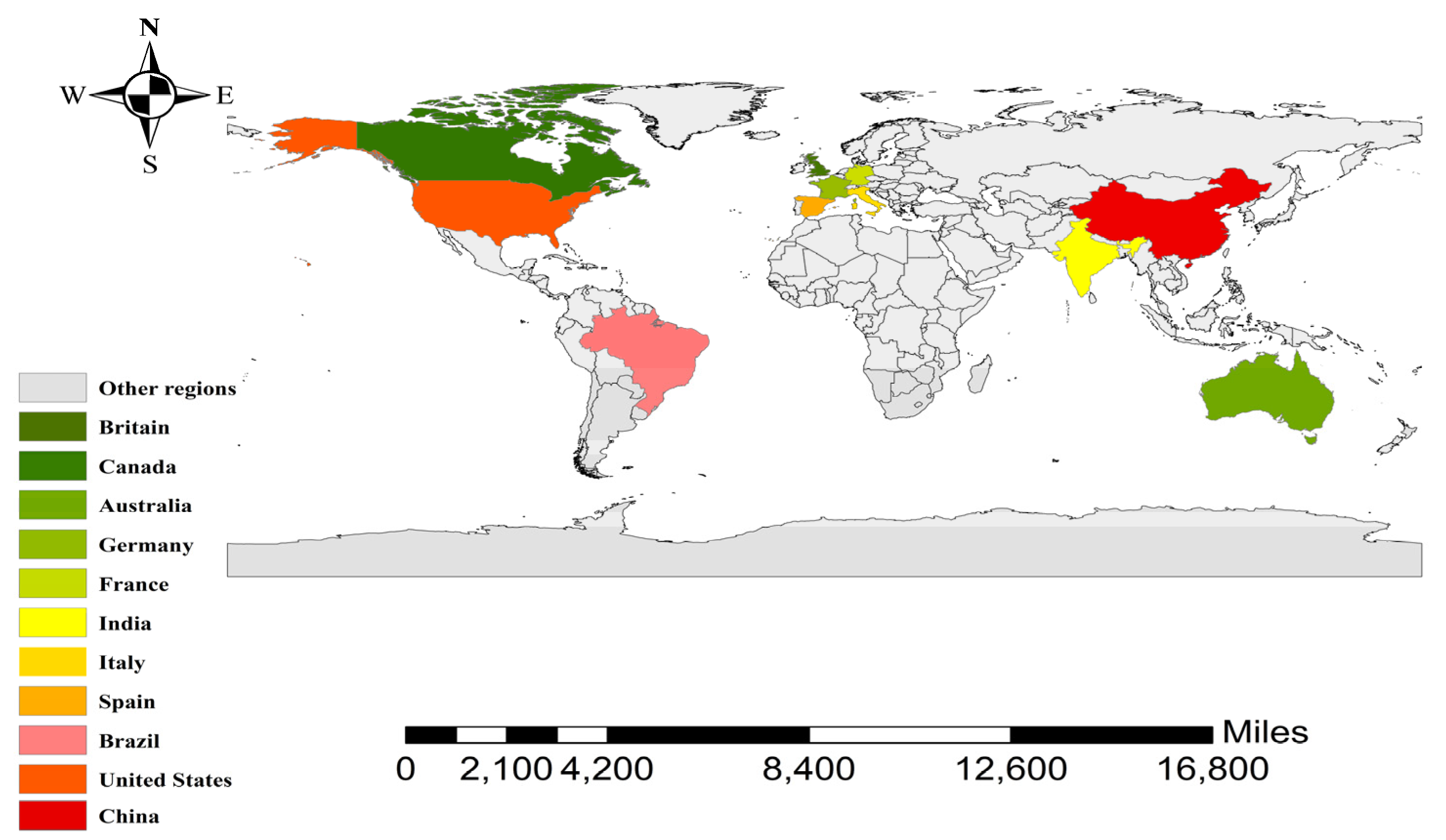
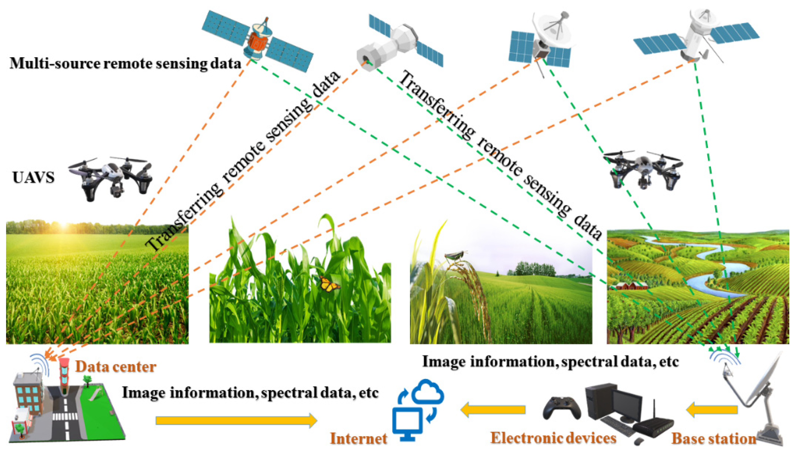
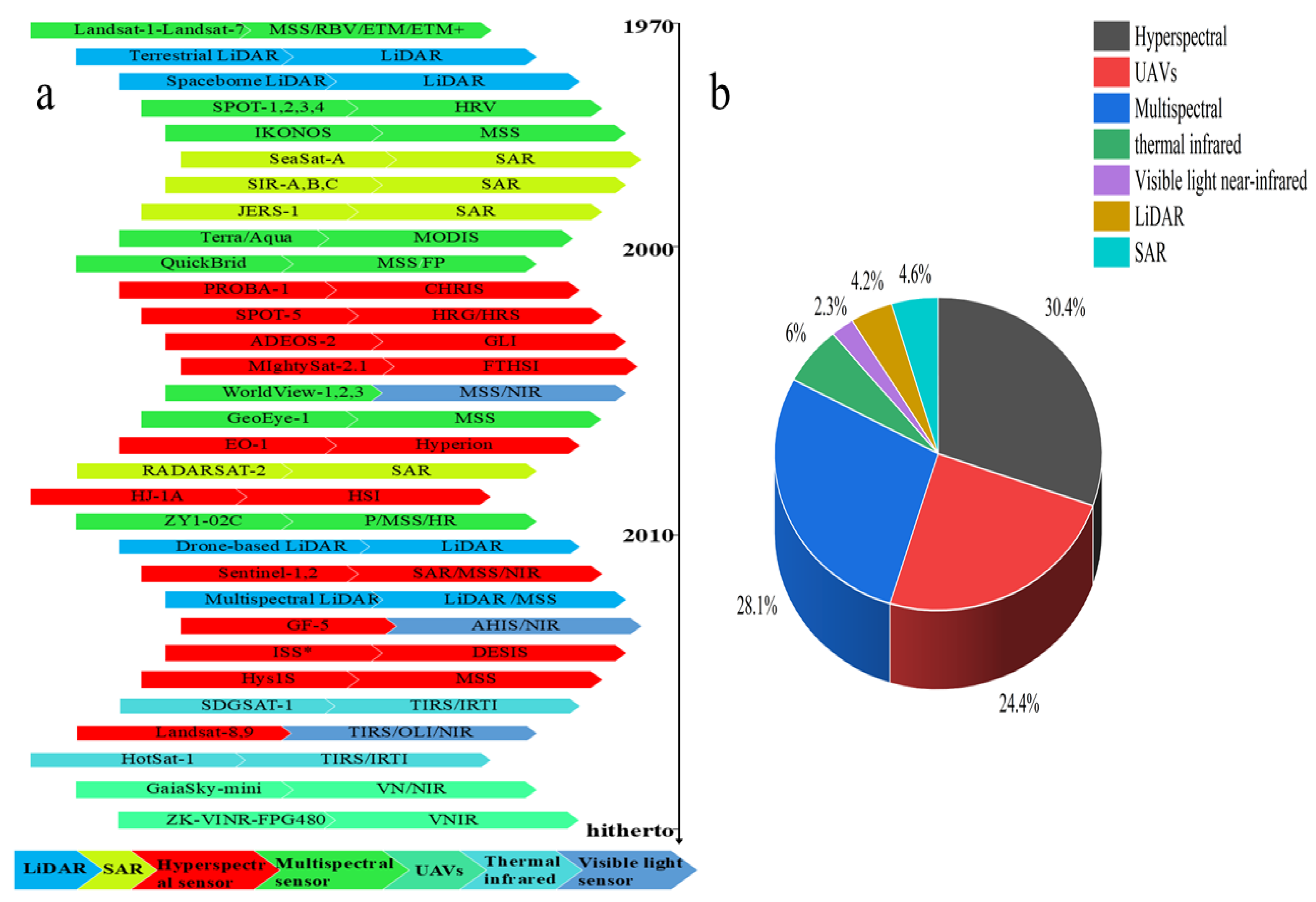
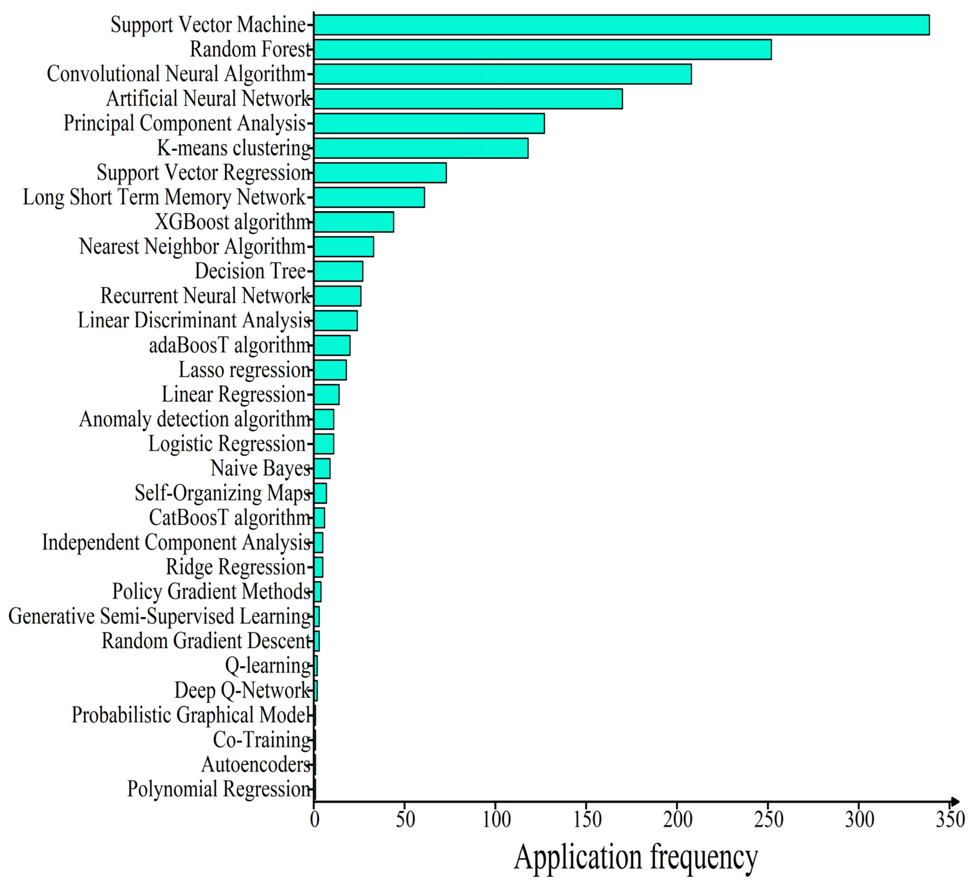
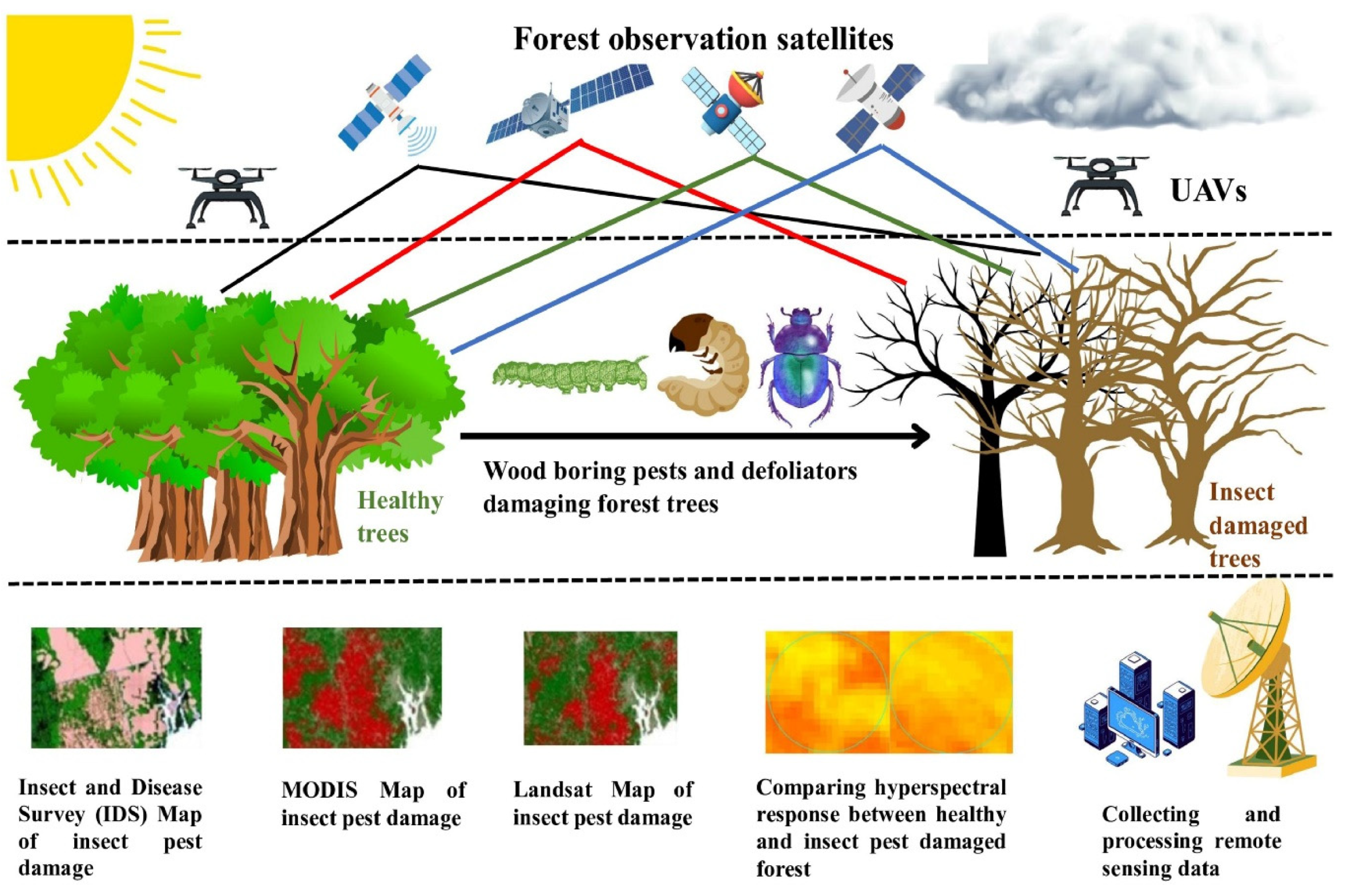

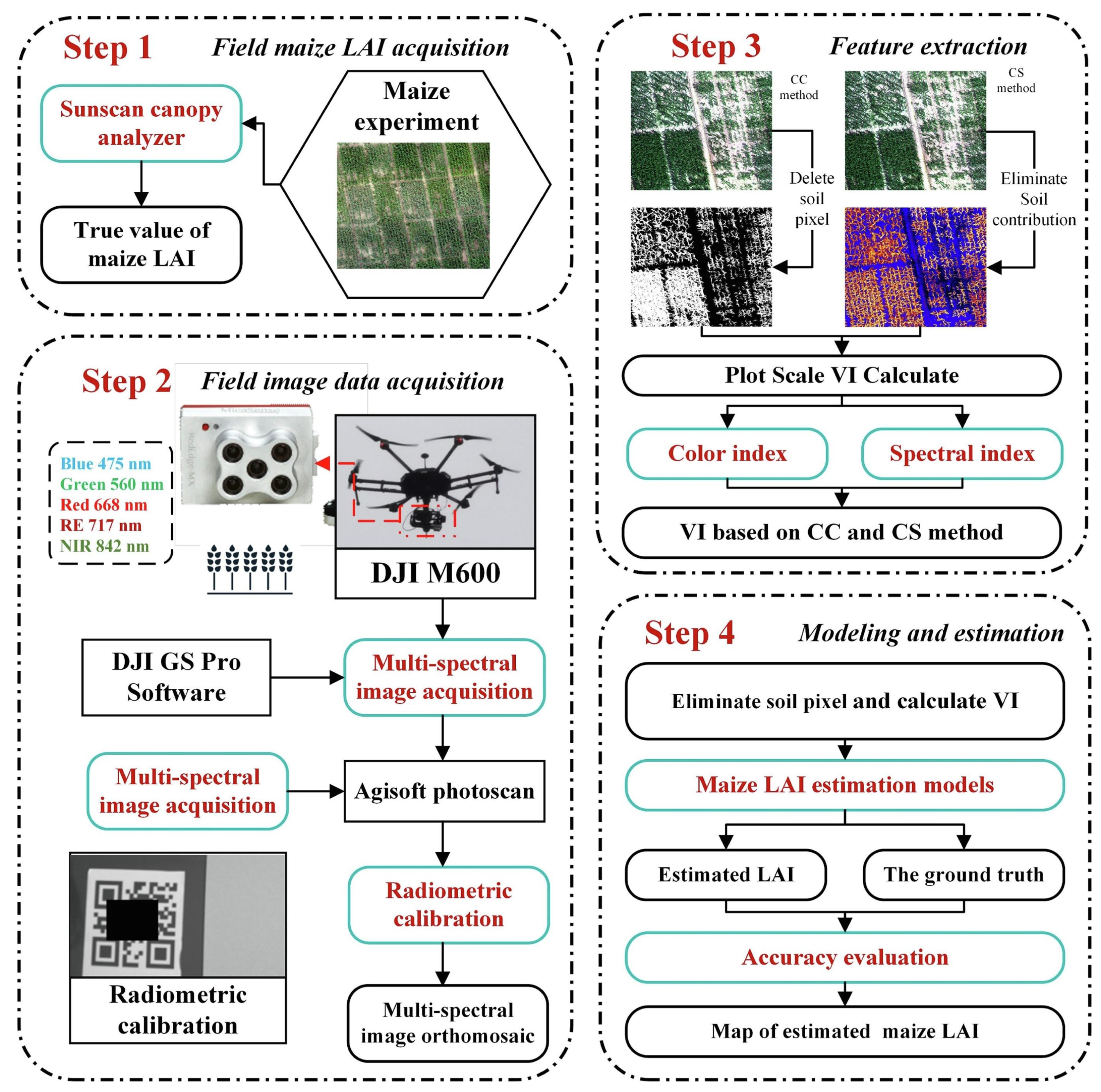

| Model Name | Application of Precision Agriculture | Reference | |
|---|---|---|---|
| Supervised Learning | Naive Bayes | Classification of different crop diseases, soil types, etc.; prediction of the yield of wheat, corn, and other crops. | [76,77] |
| Logistic Regression | Assessment of the risk level of pest occurrence; prediction of the yield of wheat, corn, and other crops. | [78,79] | |
| Linear Regression | Optimization of the amount of fertilizer application to improve the prediction accuracy of wheat, corn, and other crops yield. | [80,81] | |
| Lasso Regression | Detection of the extent to which crops are attacked by diseases and insect pests. | [82,83] | |
| AdaBoosT Algorithm | Classification and identification of different crop species and detection of crop diseases and insect pests. | [84,85] | |
| Linear Discriminant Analysis | Classification of soil types, identification of crop varieties, and determination of the effects of different soil fertilities on crop growth. | [86,87] | |
| Recurrent Neural Network | Analysis of crop growth time series data and prediction of time series changes in crop diseases and insect pests. | [88,89] | |
| Decision Tree | Selection of pest management strategies; identification of crop pest types. | [90,91] | |
| Nearest Neighbor Algorithm | Identification of different crop varieties; evaluation of soil fertility grades. | [92,93] | |
| XGBoost Algorithm | Prediction of yield of wheat, corn, and other crops based on climate, soil conditions, and other variables. | [84,85] | |
| Long Short-Term Memory Network | Forecasting the long-term trend of crop yield based on climate variables, such as precipitation and temperature, and prediction of the outbreak of crop diseases and insect pests by time series. | [94,95] | |
| Support Vector Regression | Crop growth monitoring and modeling, using remote sensing reflectance data to predict crop leaf area index, yield, etc. | [80,96] | |
| Artificial Neural Network | Identification of crop diseases and insect pests; crop growth monitoring and modeling; prediction of crop leaf area index, yield, etc. | [97,98] | |
| Convolutional Neural Algorithm | Identification of crop leaf diseases and detection of disease invasion degree of crop leaves; prediction of crop leaf area index, yield, etc. | [87,99] | |
| Random Forest | Identification of crop diseases and insect pests; crop growth monitoring and modeling; prediction of crop leaf area index, yield, etc. | [100,101] | |
| Support Vector Machine | Identification of crop diseases and insect pests; crop growth monitoring and modeling; prediction of crop leaf area index, yield, etc. | [102,103] | |
| CatBoosT Algorithm | Identification of crop leaf diseases and detection of disease invasion degree of crop leaves. | [96,104] | |
| Ridge Regression | Prediction of soil nutrients and key nutrient content based on soil sample data. | [105,106] | |
| Random Gradient Descent | Optimization of model parameters to improve the accuracy of agricultural prediction and decision-making models; application to complex agricultural system modeling and prediction. | [107,108] | |
| Semi supervised learning | Generative Semi-Supervised Learning | Assessment of soil quality; prediction of soil fertility, acidity, alkalinity, etc.; prediction and control of diseases and insect pests. | [109,110] |
| Autoencoders | Identification and classification of diseases and insect pests; assessment of the risk level of pest occurrence. | [111] | |
| Unsupervised | Co-Training | Identification, classification, and risk assessment of diseases and insect pests; soil type classification. | [112] |
| Learning | Probabilistic Graphical Model | Identification of crop diseases and insect pests; crop growth monitoring and modeling; prediction of crop leaf area index, yield, etc. | [113] |
| Independent Component Analysis | Identification, classification, and risk assessment of diseases and insect pests; soil type classification. | [114] | |
| Anomaly Detection Algorithm | Detection of crop wilt, soil moisture, and pH anomaly. | [115] | |
| Self-Organizing Maps | Classification of crops and rapid identification of soil types. | [116] | |
| K-Means Clustering | Accurate identification of crops. | [117] | |
| Principal Component Analysis | Accurate classification of crops based on their growth characteristics (such as color, texture, size, etc.). | [87] | |
| Reinforcement | Deep Q-Network | Retrieval of key growth information, such as vegetation index, to effectively monitor crop growth and development. | [118] |
| Policy Gradient Methods | Optimization of crop irrigation and fertilization strategies. | [89] | |
| Q-learning | Optimization of agricultural decision making and environmental interaction. | [119] |
Disclaimer/Publisher’s Note: The statements, opinions and data contained in all publications are solely those of the individual author(s) and contributor(s) and not of MDPI and/or the editor(s). MDPI and/or the editor(s) disclaim responsibility for any injury to people or property resulting from any ideas, methods, instructions or products referred to in the content. |
© 2024 by the authors. Licensee MDPI, Basel, Switzerland. This article is an open access article distributed under the terms and conditions of the Creative Commons Attribution (CC BY) license (https://creativecommons.org/licenses/by/4.0/).
Share and Cite
Wang, J.; Wang, Y.; Li, G.; Qi, Z. Integration of Remote Sensing and Machine Learning for Precision Agriculture: A Comprehensive Perspective on Applications. Agronomy 2024, 14, 1975. https://doi.org/10.3390/agronomy14091975
Wang J, Wang Y, Li G, Qi Z. Integration of Remote Sensing and Machine Learning for Precision Agriculture: A Comprehensive Perspective on Applications. Agronomy. 2024; 14(9):1975. https://doi.org/10.3390/agronomy14091975
Chicago/Turabian StyleWang, Jun, Yanlong Wang, Guang Li, and Zhengyuan Qi. 2024. "Integration of Remote Sensing and Machine Learning for Precision Agriculture: A Comprehensive Perspective on Applications" Agronomy 14, no. 9: 1975. https://doi.org/10.3390/agronomy14091975
APA StyleWang, J., Wang, Y., Li, G., & Qi, Z. (2024). Integration of Remote Sensing and Machine Learning for Precision Agriculture: A Comprehensive Perspective on Applications. Agronomy, 14(9), 1975. https://doi.org/10.3390/agronomy14091975