Article

Assessing the Coordination and Spatial Equilibrium of Water, Energy, and Food Systems for Regional Socio-Economic Growth in the Ili River Valley, China

1
College of Water Conservancy & Architectural Engineering, Shihezi University, Shihezi 832000, China
2
Key Laboratory of Modern Water-Saving Irrigation of Xinjiang Production Construction Group, Shihezi University, Shihezi 832000, China
3
Technology Innovation Center for Agricultural Water and Fertilizer Efficiency Equipment of Xinjiang Production & Construction Corps, Shihezi 832000, China
4
Key Laboratory of Northwest Oasis Water-Saving Agriculture, Ministry of Agriculture and Rural Affairs, Shihezi 832000, China
*
Author to whom correspondence should be addressed.
Agronomy 2024, 14(9), 2037; https://doi.org/10.3390/agronomy14092037
Submission received: 9 July 2024 / Revised: 30 August 2024 / Accepted: 3 September 2024 / Published: 6 September 2024
(This article belongs to the Special Issue Land and Water Resources for Food and Agriculture—2nd Edition)

Abstract

:
Water resources, energy, and food are fundamental resources for high-quality regional development. In the process of rapid regional economic growth, integrating the utilization of these fundamental resources has become a critical challenge for achieving high-quality development in the Ili River Valley. To explore the coordinated development status of water, energy, and food (W-E-F) in the Ili River Valley, we constructed a comprehensive evaluation indicator system for the regional W-E-F system, and we calculated and analyzed the comprehensive development level, coupling coordination degree, and spatial equilibrium of the W-E-F system from 2008 to 2020. The results indicate that the comprehensive evaluation indicators of the W-E-F system in the Ili River Valley exhibited an overall upward trend, indicating that the system is moving in a positive direction. Among them, the water subsystem’s comprehensive evaluation indicator showed an upward trend but fluctuated significantly during the study period, with the excessive proportion of agricultural water consumption being a key factor affecting its development. Furthermore, the comprehensive evaluation indicator of the energy subsystem showed a slight downward trend, indicating constraints on the development of energy subsystems. Agricultural surface pollution and industrial waste pollution are the primary factors limiting its development. Meanwhile, due to the significant attention from governments at all levels, the food subsystem has been developed rapidly, with its comprehensive evaluation indicator showing a significant upward trend, which shows that the region is actively promoting food production capacity enhancement initiatives. Additionally, the coupling degree of the W-E-F system remained in a state of coordinated coupling, with an average value between 0.7 and 1.0, indicating a high overall development level, and that the development of each resource affects and constrains that of the other two. The coupling coordination degree transitioned through phases of near coordination, primary coordination, good coordination, and moderate coordination, and all counties and cities showed a tendency to evolve towards high coupling, indicating significant potential for the further development of the regional W-E-F system coupling and coordination. Among the subsystems, the food subsystem exhibited the highest spatial equilibrium (0.78) and the smallest spatial disparities, while the energy subsystem demonstrated the lowest spatial equilibrium (0.40) and the largest spatial disparities. There were still significant issues with the utilization and equilibrium of the regional resource allocation, necessitating integrated planning for the coordinated development of the W-E-F system to achieve sustainable resource management and high-quality ecological and economic development.

1. Introduction

Globally, approximately 70% of water is utilized for agricultural production, while 30% of energy consumption is allocated to food production and supply [1]. Concurrently, around 30% of food is either contaminated or wasted annually. Water, energy, and food are strategic resources essential for human survival and are intricately linked to socio-economic development [2]. Projections suggest that by 2050, the global demand for water, energy, and food could rise by 55%, 80%, and 60%, respectively, which would further aggravate the shortage of resources [3,4]. The 2011 conference on the water-energy-food (W-E-F) nexus in Bonn first termed the linkage between the three as a “nexus”, highlighting that the relationship between them is interdependent, mutually constraining, and interacting, and that, together, they influence the high-quality development of a country or region.
Xinjiang is one of China’s major food production bases, with 7066.67 thousand hectares of arable land, ranking fifth in size nationwide. The state has emphasized that Xinjiang’s food production should transition from a “balance within the region and a slight surplus” to a “surplus within the region and supply to the state”, making Xinjiang a “reserve granary” of China. However, Xinjiang is a typical inland arid zone with low precipitation and high evaporation [5,6], encompassing one-sixth of China’s land area but possessing less than 4% of its water resources. The shortage of water resources severely hampers agricultural development in Xinjiang. The Ili River Valley stands out as the region’s most abundant water source, accounting for 38% of Xinjiang’s total water resources [7]. Therefore, utilizing the abundant water resources of the Ili River Valley for agricultural production has become a top priority for the high-quality development of agriculture in Xinjiang, and the Ili River Valley has become an “important backup base for national food security”. Additionally, the Ili River Valley is one of the most important coal bases in Xinjiang, with a wide variety of energy sources, including coal, copper, lead, zinc, and other mineral resources. As crucial strategic resources for regional economic development, water, energy, and food security are directly related to regional economic security, social stability, and national security.
Previous studies reveal that the predominant research themes within the W-E-F system are mainly focused on the comprehensive evaluation of nexus relationships [8,9], food security and the virtual water trade [10,11], water use efficiency improvement [12,13], and sustainable development [14,15]. The research methods include coupled coordination models [16,17], symbiotic relationships [18,19], and synergistic optimization models, among others [20,21]. For example, Sui et al. [18] studied the coordination of W-E-F coupling in the Yangtze River region and its provinces, concluding that the coordination is more robust in the upper reaches of the Yangtze River than in the middle and lower reaches. Zhang et al. [22] studied the efficiency of W-E-F coupling in 94 cities in the Yellow River Basin, concluding that the energy subsystem is a key constraint on the normal development of the regional W-E-F nexus. Elena et al. [23] evaluated the impact of the W-E-F nexus on the environment in Mexico City, concluding that the normal functioning of the energy and food sectors has a negative impact on regional water quality. Zeina et al. [24] used the W-E-F system to study the resource potential of the Rabia region in Egypt, concluding that the study could significantly contribute to sustainable regional development. Patricia et al. [25] investigated how the W-E-F system can regulate the impacts of climate extremes on regional impacts, concluding that institutional solid action can mitigate these impacts. The analysis shows that most of the research scales focus on the global scale [26,27,28], national scale [7,29,30], basin scale [31,32,33], provincial scale [34,35,36], and other large- to medium-sized scales, while there are limited studies on the local and municipal scales. From the perspective of the regional and municipal scales, such as the Ili River Valley, relevant research can analyze the internal differences of the region more accurately and avoid the uncertainties and ambiguities brought by the large-scale research units. It is crucial to understand the unique distribution of resources and the region’s development potential and to improve the guidance of actual work. Moreover, the Ili River Valley is a significant food production base in Xinjiang, as well as energy-rich and the wettest region in Xinjiang, and research on resource sustainability in the region is crucial. Therefore, in this study, the Ili River Valley is examined as the focal point, with a selection of 24 evaluation criteria for the regional W-E-F system. The study uses the comprehensive evaluation indicator model to assess and analyze the comprehensive development level of the W-E-F system in the Ili River Valley from 2008 to 2020. It utilizes the coupling coordination model to explore and study the W-E-F system’s coupled and coordinated development situation. Additionally, the study introduces the spatial equilibrium model to analyze the spatial equilibriums of the water, energy, and food subsystems and indicators to identify the key factors restricting the coordinated development of resources and food in the Ili River Valley, thereby offering data support and a theoretical foundation for the sustainable advancement of the regional W-E-F system.

2. Materials and Methods

2.1. Overview of the Study Area

The Ili River Valley, situated in the western section of the Tianshan Mountain Range in China, is encompassed by mountainous terrain to the north, east, and south [7]. It exhibits a trumpet-shaped geomorphology opening to the west (Figure 1) and connects to the Tashkurgan Mountain Range through Mount Bogda. It has been a main route for trade, cooperation, and cultural exchanges between China and Central Asia since ancient times, earning it the moniker the “Gateway of Xinjiang”. Characterized by a temperate continental climate, the valley experiences mild and humid weather conditions, with an average annual temperature of 10.4 °C, approximately 2870 h of sunshine annually, and an average yearly precipitation of 417.6 mm. The mountainous areas within the valley receive even higher precipitation levels, ranging from 600 to 1000 mm, making it the wettest area in Xinjiang, known as the “Jiangnan Beyond the Seas”. Furthermore, endowed with favorable natural attributes, the Ili River Valley boasts significant advantages for agricultural development, encompassing 722.67 thousand hectares of arable land, and serving as a crucial reserve for national food security. Additionally, the valley is rich in natural resources, including energy sources, mineral deposits, and coal reserves, establishing it as one of the primary coal production hubs in Xinjiang.

2.2. Methodology

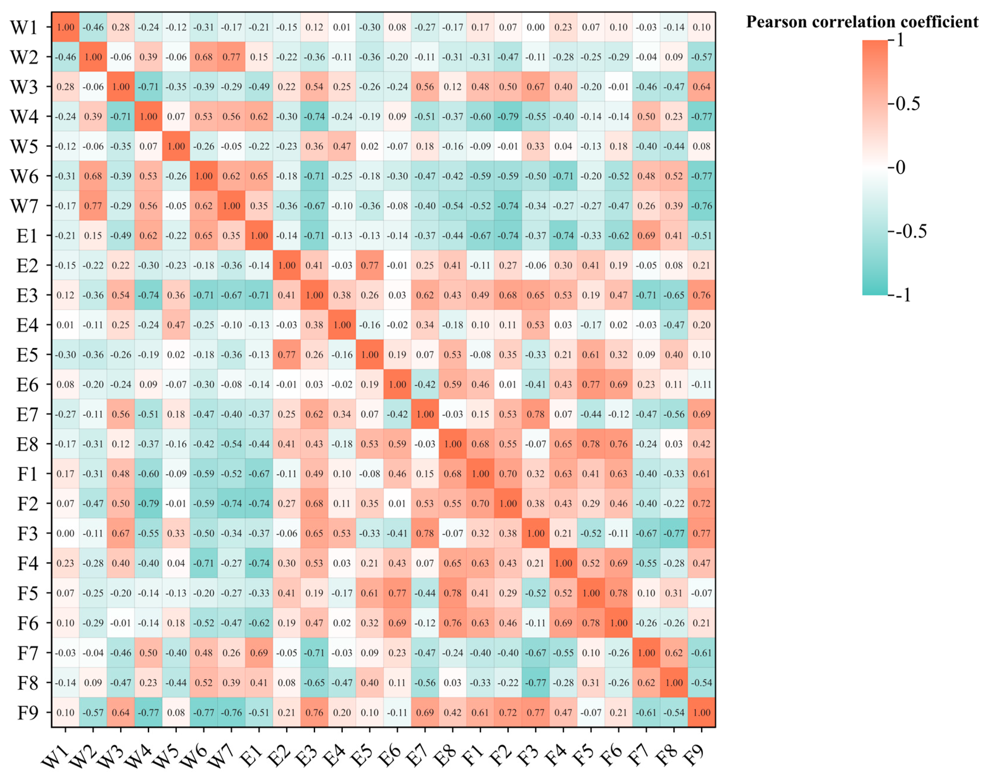
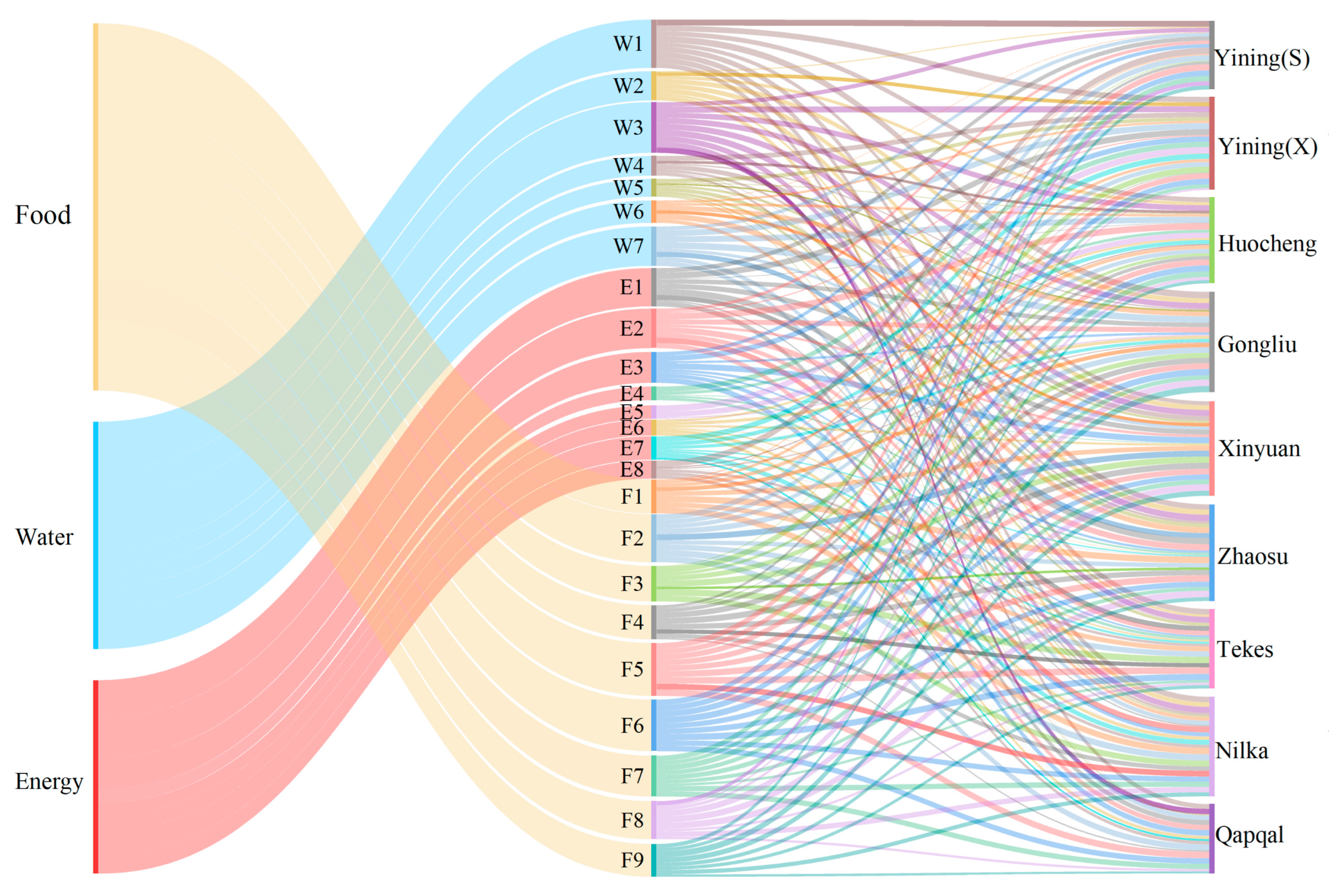
2.2.1. Construction of Comprehensive Evaluation Indicator System of W-E-F System in Ili River Valley

The W-E-F system is characterized by the extensiveness, complexity, and diversity of its connections. The academic community has yet to establish consistent normative guidelines for developing indicators. However, the selection of indicators adheres to the principles of representativeness, scientific authenticity, and operability. It is essential to retain indicators that can better reflect the system’s security while avoiding the blind increase in the number of indicators. Indicators that are highly representative but difficult to access can be transformed using scientific methods or appropriately excluded [37]. This study comprehensively considered factors such as the living and production capacity, demand, and socio-economic development level of the Ili River Valley. It selected and set criteria for the evaluation indicators of the subsystem, drawing on the relevant literature [3,35,37]. to list all indicators that are suitable for evaluating the development level of the subsystems. Additionally, taking into account the resource endowment status of the study area and the availability of data, it selected 30 evaluation indicators that are sufficient to support the establishment of each subsystem and are in line with characterizing the coordinated development of regional resources. Furthermore, it conducted Pearson correlation analysis on the selected indicators, revealing weak correlations between indicators of different subsystems, while some within the same subsystem had high correlations, with coefficients above 0.8, indicating redundancy. Consequently, redundant indicators were removed. Ultimately, 24 evaluation indicators were identified as the most suitable for characterizing the coordinated development of regional resources, forming a comprehensive evaluation indicator system for the W-E-F system in the Ili River Valley (Table 1). The analysis of the correlation between the indicators is shown in Figure 2.

2.2.2. Data Standardization and Weight Determination

  • Data standardization
To mitigate the impact of the disparities in scale among the original data units of the assessment metrics, standardization of the original data was conducted using the methodology outlined in the relevant studies [38,39]. The calculation formulas are as follows:
1.
Positive indicators:
x i j = ( x i j x i j ( min ) ) / ( x i j ( max ) x i j ( min ) )
2.
Negative indicators:
x i j = ( x i j ( max ) x i j ) / ( x i j ( max ) x i j ( min ) )
where x′ij is the standardized data value; xij is the original data value; the variables xij(max) and xij(min) denote the maximum and minimum values of the indicators, respectively.
  • Determination of indicator weights
To reduce the error of a single calculation method, this study employed a comprehensive assignment method that combines the stratification analysis method and the entropy-weighting method to calculate the weights of the indicators, as described in the study by Bai [40].

2.2.3. Calculation of the Comprehensive Evaluation Indicators

W ( x ) = i = 1 n w i x i j
E ( y ) = i = 1 n e i y i j
F ( z ) = i = 1 n f i z i j
where W(x), E(y), F(z) represent the comprehensive evaluation indicators of the water, energy, and food subsystems [41], respectively; wi, ei, fi represent the weights of the individual indicators of each subsystem, respectively; x′ij, y′ij, z′ij represent the normalized values of the individual indicators of each subsystem, respectively.

2.2.4. Coupling Coordination Model

The coupling coordination degree model can characterize the level of coordination development among different systems. According to previous research results [2,3], it was used to analyze and study the degree of coordination of the water, energy, and food subsystems in the Ili River Valley. The calculation steps are as follows:
1.
Coupling degree calculation formula:
C = ( 3 × W ( x ) E ( y ) F ( z ) 3 ) / ( W ( x ) + E ( y ) + F ( z ) )
where C represents the coupling degree, which will be categorized [17], and the specific grading standard is shown in Table 2;
2.
Coordination degree calculation formula:
T = α W ( x ) + β E ( y ) + γ F ( z )
where T represents the degree of coordination, and α, β, and γ represent the weights of the water, energy, and food subsystems, respectively. Referring to the results of previous studies [42,43], combined with the actual situation of the region, this study considers that the statuses of the water resource, energy, and food subsystems in the study area are equally significant, each assigned a weight of 1/3;
3.
Coupling coordination degree calculation formula:
D = C × T
where D is the value of the coupling coordination degree, referring to the previous research results [17,39], and the specific grading standard is shown in Table 3.

2.2.5. Spatial Equilibrium Model

The spatial equilibrium model is now widely used in urban planning, regional economic development, resource allocation, and other fields. At its core, the model quantitatively assesses the balance in the spatial distribution of regional resources, populations, economic activities, and other factors, thereby facilitating a deeper understanding of regional developmental disparities and offering theoretical guidance for policy making, planning design, and optimal resource allocation [45]. Drawing on the findings of previous research [3], the water resource spatial equilibrium model was employed to delineate the spatial equilibrium of the assessment indicators of the W-E-F system within the Ili River Valley. The spatial equilibrium coefficient was calculated as shown in Equation (9), and the spatial equilibrium degree was calculated as shown in Equation (10):
Y = 0 ,   x i < x i ¯ Δ x i 1 ( x i x i ¯ + Δ x i 1 ) / Δ x i 1 ,   x i ¯ Δ x i 1 x i x i ¯ ( x i ¯ x i + Δ x i 2 ) / Δ x i 2 ,   x i ¯ x i x i ¯ + Δ x i 2 0 ,   x i > x i ¯ + Δ x i 2
where Y denotes the spatial equilibrium coefficient; xi signifies the eigenvalue of the region (i); x i ¯ is the eigenvalue when the spatial equilibrium coefficient equals 1, and x i ¯ is set to be the average value of xi; x i ¯ − Δxi1 and x i ¯ + Δxi2 are the critical points where the eigenvalues are less than and greater than x i ¯ when the spatial equilibrium coefficient equals 0, respectively;
U = i = 1 n ( S i × Y i ) / i = 1 n S i
where U denotes the degree of spatial equilibrium, n represents the total number of spatial units, and Si is the area of the ith spatial unit. The specific division criteria of the spatial equilibrium [46] are shown in Table 4.

2.3. Data Sources

Water resource data, such as annual precipitation and water consumption, were sourced from Xinjiang Water Resources Bulletin and Ili Kazakh Autonomous Prefecture Water Resources Bulletin. Energy and environmental data, such as diesel used in agriculture and electricity generation, were sourced from the Ili Kazakh Autonomous Prefecture Environmental Statistical Annual Report and the Ili Kazakh Autonomous Prefecture Statistical Yearbook. Comprehensive data, such as food production, cultivated land area, and effective irrigated area, were obtained from the Ili Statistical Yearbook, the Ili Kazakh Autonomous Prefecture Statistical Yearbook, and the Xinjiang Statistical Yearbook. To ensure completeness and accessibility, the data time series was standardized to 2008–2020. Since Khorgos City was established in 2014 and has significant data gaps, it was excluded from this study. Similarly, Kekedala City, which belongs to the Fourth Division of the Xinjiang Production and Construction Corps, was not considered. For map completeness, Khorgos City and Kekedala City are marked in grey. To avoid confusion due to the same names, Yining City is labeled as Yining(S) and Yining County as Yining(X) in the analysis.

3. Results

3.1. Changes in the Comprehensive Evaluation Indicators of the W-E-F System in the Ili River Valley

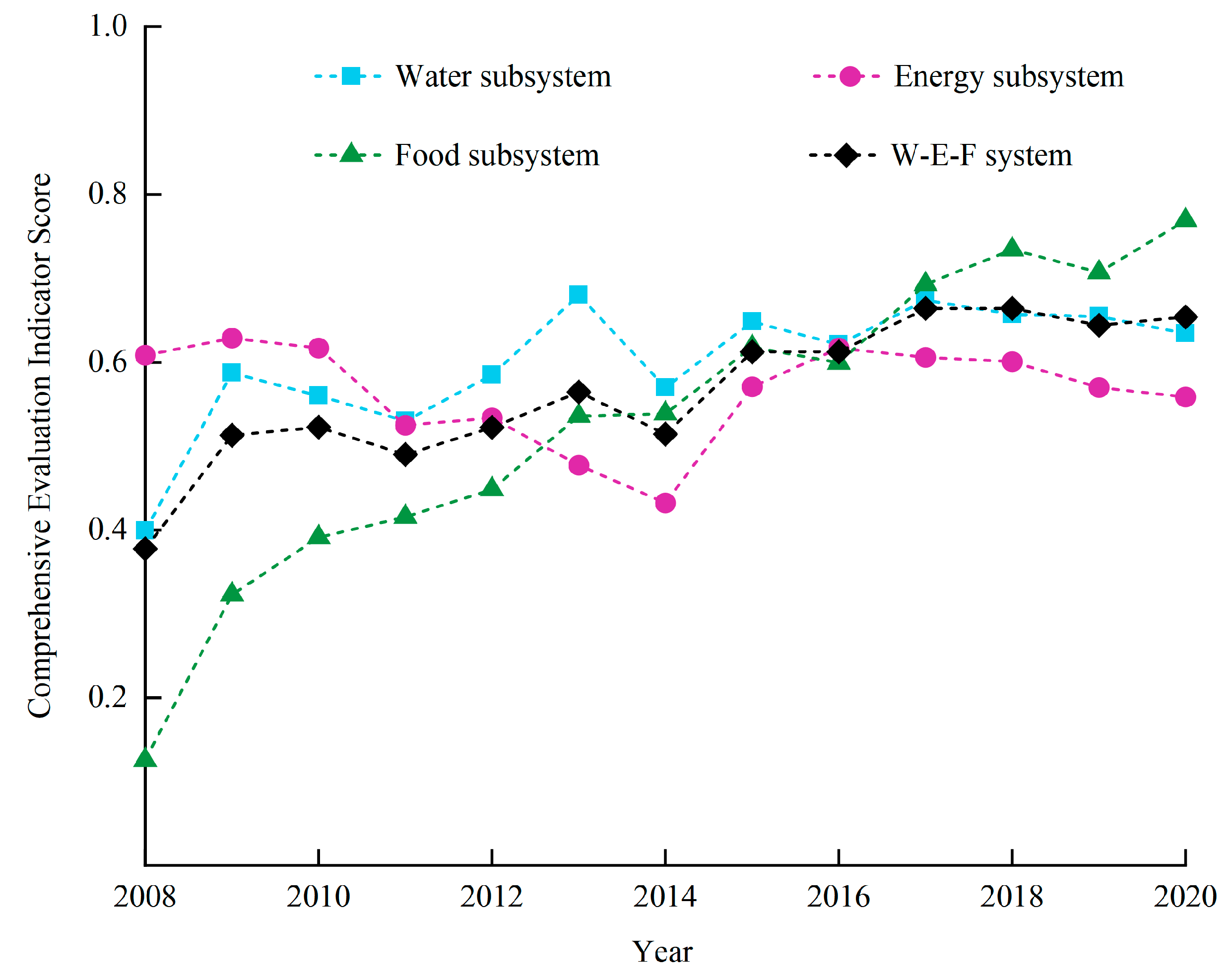
3.1.1. Analysis of Time Series Changes in the Comprehensive Evaluation Indicators

The comprehensive evaluation indicator model was employed to ascertain the comprehensive evaluation indicators of both the W-E-F system and its subsystems in the Ili River Valley (Figure 3). As illustrated in Figure 3, the comprehensive evaluation indicator of the W-E-F system in the Ili River Valley exhibited a general upward trajectory throughout the study period, escalating from 0.378 to 0.674, with a mean yearly growth rate of 5.24%. However, the growth rate was slow and fluctuating. Analysis indicates that the food subsystem’s development was highly prioritized, maintaining a robust upward trend during the period, thereby positively influencing the comprehensive evaluation indicator of the W-E-F system, while the water and energy subsystems exhibited varying degrees of fluctuation over time. Consequently, influenced by the combined effects of the subsystems, the comprehensive evaluation indicator of the W-E-F system in the Ili River Valley manifests a fluctuating upward trend over the time series, with the overall growth rate remaining relatively modest.
The comprehensive evaluation indicator of the water subsystem generally exhibited an upward trend, rising from 0.399 to 0.703, with a mean yearly growth rate of 5.45%, although significant fluctuations were observed throughout the study period. Notably, significant downward trends were observed in 2011 and 2014, followed by an overall recovery post-2014, albeit at a slower growth rate. The primary reason is that, in 2011, the precipitation in the Ili River Valley was severely reduced compared to previous years, and there was a severe drought in April; in 2014, it suffered the most severe drought in 19 years, with only 38.1 mm of regional precipitation from May to June, which was 56% less than the same period of the previous year. A significant factor contributing to the water subsystem’s limited development and slower growth is the disproportionate use of water by the agricultural sector. Analysis indicates that from 2008 to 2020, except for Yining City, where the proportion of agricultural water use remained at approximately 60%, the proportion of agricultural water use in the other counties and cities exceeded 80%, with some areas surpassing 95%.
The comprehensive evaluation indicator for the energy subsystem initially decreased, then increased, and tended to stabilize, but overall exhibited a slight downward trend, with a mean yearly growth rate of –0.30%. The lowest value was recorded in 2014, at 0.434. Analysis suggests that the limited development of the energy subsystem is primarily due to agricultural surface pollution and industrial waste pollution. From 2008 to 2014, the use of chemical fertilizers in the Ili River Valley increased from 9.10 million tons to 11.76 million tons, a 29.23% rise; pesticide use grew from 0.04 million tons to 0.06 million tons, a 50% increase; and mulch film use rose from 0.42 million tons to 0.63 million tons, likewise a 50% increase. This reflects a growing dependence on these inputs in local agriculture. Meanwhile, industrial waste emissions have risen sharply with the development of energy-intensive industries such as coal chemicals, iron and steel, and pharmaceuticals. From 2009 to 2015, wastewater emissions surged from 11.49 million tons to 93.47 million tons, an increase of 713.60%; emissions of exhaust gases soared from 288.48 billion m3 to 1848.86 billion m3, an increase of 540.90%; and emissions of solid wastes increased from 855,700 tons to 4,643,000 tons, an increase of 442.60%. These data reveal the severe challenges faced in developing the energy subsystem.
Changes in the comprehensive evaluation indicator of the food subsystem exhibited an impressive upward trend, with a minimum of 0.126 in 2008 and growth to the highest level in the subsystem in 2020, reaching 0.769, marking the most significant rise with a mean yearly growth rate of 20.85%. The continuous rise in the comprehensive evaluation indicator of the food subsystem is primarily attributable to the government’s strong emphasis on food security in recent years, along with the implementation of various policies to enhance the food production capacity. As a crucial food production base, counties and cities in the Ili River Valley have responded positively to these policies, significantly advancing food production. In 2008, the planted area of crops was 373.33 thousand hectares, and by 2020, it exceeded 666.67 thousand hectares, with food crops expanding from 240.00 thousand hectares to 380.00 thousand hectares. The increase in the planted area of crops and the increase in the unit food output have had a beneficial impact on the advancement of the food system. However, food security must be balanced with the coordinated development of the water and energy subsystems to enhance the overall security and integration of the W-E-F system in the Ili River Valley, ensuring sustainable resource development.

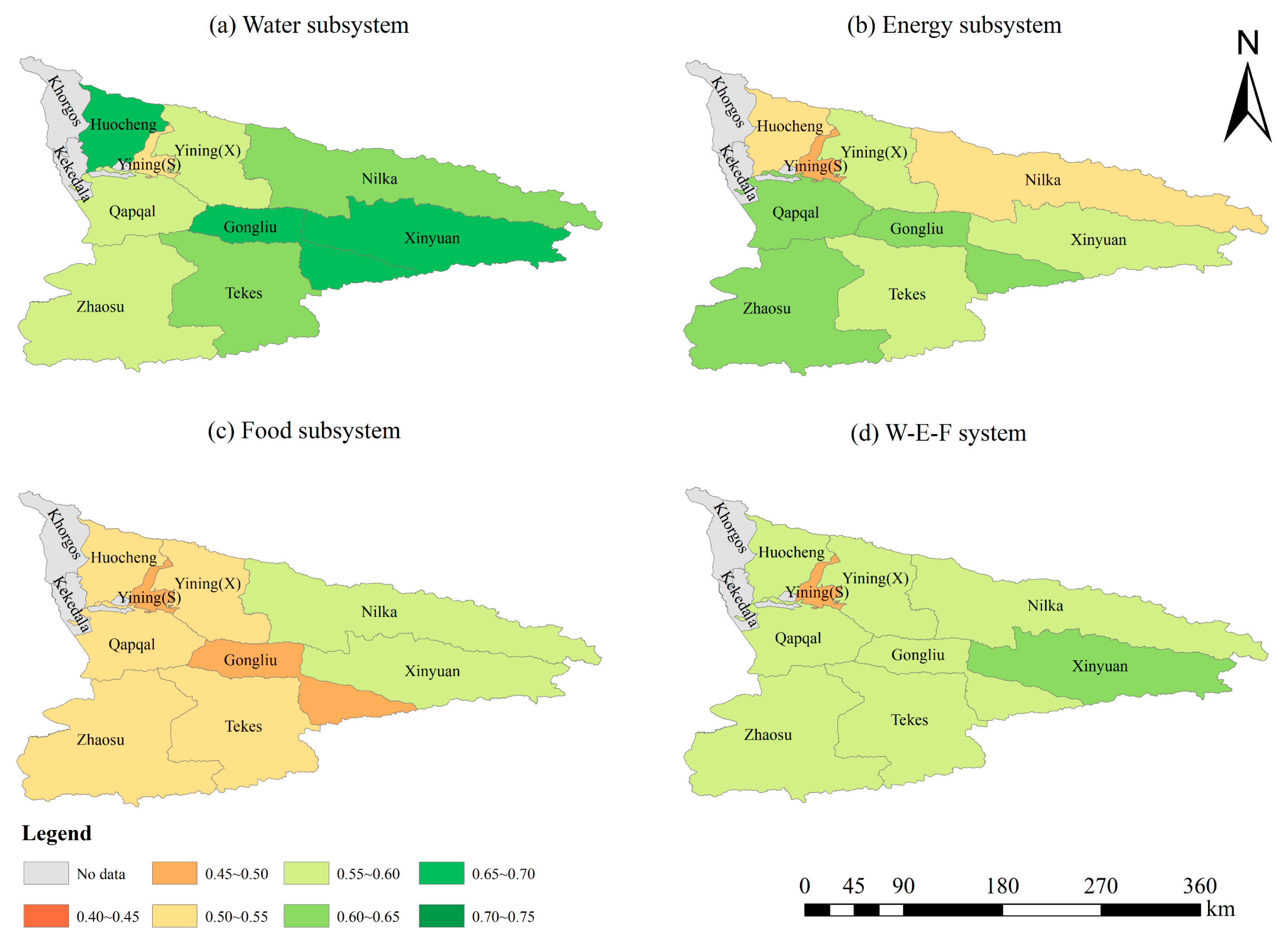
3.1.2. Analysis of Spatial Changes in the Comprehensive Evaluation Indicator

Figure 4 illustrates the changes in the mean value of the comprehensive evaluation indicator for the W-E-F system in the Ili River Valley from 2008 to 2020. Throughout the study period, the mean value of the comprehensive evaluation indicator for the overall W-E-F system in the Ili River Valley was 0.569, which is at a medium–high level. Due to varying socio-economic development conditions, the development level of the comprehensive indicator in each county and city was affected. Notably, the composite indicators of Yining County and Yining City were lower than the mean level, with Yining City being the lowest at 0.503. The mean value of the comprehensive indicator for the remaining counties and cities exceeded that of the overall W-E-F system in the Ili River Valley, ranging between 0.560 and 0.603.
In the water subsystem, the mean value of the comprehensive evaluation indicator in Huocheng County, Xinyuan County, Gongliu County, Tekes County, and Nilka County is higher than the average value of the Ili Valley (0.610), with Huocheng County having the highest value at 0.691 and Yining City having the lowest at 0.503. The mean value roughly reflects the superiority of the spatial trend of the eastern and western counties and cities to that of the central counties and cities. The average value of the energy subsystem is 0.567, with Gongliu County, Qapqal County, Zhaosu County, Xinyuan County, and Tekes County all scoring higher than this average. Gongliu County reached 0.638, the highest among all the counties and cities, while Yining City had the lowest value at 0.499. The average value of the energy subsystem’s comprehensive evaluation indicator roughly reflects the trend that southern counties are superior to northern counties spatially. The average value of the food subsystem is 0.520. Nilka County, Xinyuan County, Qapqal County, Yining County, and Tekes County all have values higher than the average. Nilka County has the highest value at 0.583, while Yining City has the lowest at 0.471, roughly reflecting the trend that eastern counties and cities outperform western counties and cities.

3.2. Analysis of the Coupling Degree of the W-E-F System and the Changes in the Coupling Coordination Degree in the Ili River Valley

3.2.1. Analysis of the Changes in the Coupling Degree of the W-E-F System in the Ili River Valley

Figure 5 illustrates the changes in the coupling degree score of the W-E-F system in the Ili River Valley from 2008 to 2020. As illustrated in Figure 5, the coupling degree of all the counties and cities was at its lowest value in 2008. Among them, the coupling degree values of Yining County, Tekes County, and Nilka County ranged between 0.6 and 0.7, which were in the stage of high coupling, while the coupling degree values of the remaining counties and cities ranged between 0.7 and 1.0, which were in the stage of coordinated coupling. The primary reason is that the comprehensive evaluation indicator of the food subsystem in each county and city was at a low level of 0.13 in 2008, which negatively affected the development of the W-E-F system coupling degree. After 2008, the food subsystem experienced significant growth, improving the coupling degree. However, agricultural production in the Ili River Valley still largely depends on diffuse irrigation, characterized by outdated water management practices, equipment, and low irrigation technology [47]. The lack of water-saving irrigation technology increases the dependence on water resources for food production, thereby increasing the coupling degree between the two subsystems. The increased use of chemical fertilizers and pesticides in food production has strengthened the coupling between the food and energy subsystems. Overall, from 2009 to 2020, the coupling degree of the W-E-F system in the Ili River Valley exhibited a stable development trend, with coupling scores in all counties and cities ranging from 0.8 to 1.0, indicating a high level of development and strong system integration.

3.2.2. Changes in the Coupling Coordination Degree of W-E-F System in the Ili River Valley

The coupling coordination degree model was applied to determine the W-E-F system’s coupling coordination degree in the Ili River Valley from 2008 to 2020, as illustrated in Figure 6. Throughout this period, the coupling coordination degree generally exhibited a fluctuating upward trend, transitioning through phases of near, primary, good, and moderate coordination. Moderate coordination was the most prevalent, accounting for 53.85%. However, due to fluctuations in the growth of the three subsystems and occasional negative growth trends, the overall growth rate remained relatively stable, with a mean yearly growth rate of 3.65%. The development trend of the coupling coordination degree varied among the counties and cities, but no values fell below 0.30, indicating the absence of moderate, severe, and extreme dislocation. By 2017, all counties and cities, except Yining City, had reached moderate or good coordination. This improvement was largely attributable to enhanced farmland water conservancy facilities, increased practically irrigated areas, and higher ecological water consumption after 2014, which collectively boosted the coupling coordination degree [48].
As illustrated in Figure 6, from 2008 to 2020, the W-E-F coupling coordination degree of the Ili River Valley in the spatial dimension exhibits a trend where the eastern and western counties and cities perform better than the central counties and cities. In the temporal dimension, the coupling coordination degree shows varying degrees of rising trends, with the overall development categorized into two types: “stable-rising” and “fluctuation-rising”. The stable-rising type includes Yining County, Tekes County, Xinyuan County, Gongliu County, Nilka County, and Huocheng County, with a growth rate of coupling coordination values exceeding 3.00%. The fluctuating-rising type is mainly observed in Yining City. The coupling coordination degree level fluctuates between primary and moderate coordination, exhibiting an “increase–decrease–increase–decrease” trend. Primary coordination dominates, accounting for 61.50% of the years, with a mean yearly growth rate of 0.10%. Analysis shows that from 2011 to 2015, Xinjiang’s industrial level developed rapidly, and, at the same time, counties and cities actively promoted the action of food production capacity enhancement. As a major industrial city in the Ili River Valley, Yining City was at the forefront of the counties and cities during the study period in terms of industrial energy consumption, industrial water consumption due to industrial development, and agricultural energy consumption due to agricultural production. Consequently, the coupling coordination degree in Yining City was in a constantly fluctuating trend and at a relatively low grade due to the influence of resource coordination.

3.3. Analysis of the Spatial Equilibrium Degree of the W-E-F System in Ili River Valley

We utilized the spatial equilibrium degree model to determine the W-E-F system’s spatial equilibrium degree in the Ili River Valley from 2008 to 2020 (Figure 7 and Figure 8). Regarding the spatial equilibrium of the indicators, the spatial equilibrium degrees of F5 (Proportion of food crop-planted area), F6 (Proportion of planting area of crops with high water consumption), W3 (Proportion of water consumption in agriculture), F2 (Per hectare food production), and W1 (Annual precipitation) all exceed 0.8, indicating a state of basic equilibrium. Among them, F5 (Proportion of food crop-planted area) has the highest spatial equilibrium degree, reaching 0.89, indicating that the spatial differences between regions are minimal and the indicators exhibit similar development trends across different counties and cities. The spatial equilibrium degrees of E1 (Diesel use in agriculture), F8 (Natural population growth rate), F3 (Cultivated land area per capita), F4 (Effective irrigated area), F1 (Per capita food production), W7 (Water consumption per unit of food production), E2 (Gross power of agricultural machinery), and F7 (Fertilizer load) are maintained between 0.6 and 0.8, indicating a more balanced state. This suggests that the spatial differences of these indicators between regions are gradually decreasing and that the distributional relationship between various elements is developing in the direction of gradual stabilization. The spatial equilibrium degrees of E4 (Electricity generation), E5 (Industrial wastewater emissions), E6 (Industrial waste gas emissions), W4 (Proportion of water consumption in industry), W5 (Proportion of water consumption for domestic purposes), and E8 (SO2 emissions) range between 0 and 0.4, indicating an unbalanced state, which is attributable to the centralized production of energy. Among them, E5 (Industrial wastewater emissions) has the lowest spatial equilibrium degree at 0.18, indicating significant differences in the industrial development statuses of counties and municipalities.
Analyzing the spatial equilibrium of the subsystems reveals that the spatial equilibrium is most pronounced in the food subsystem, with the water subsystem following closely behind. In contrast, the energy subsystem demonstrates the lowest level of spatial equilibrium. This suggests that the food subsystem displays the lowest degree of spatial variability, followed by the water subsystem, while the energy subsystem demonstrates the highest spatial variability. This suggests that the food subsystem in each county and city follows a similar development trend. Combined with the previous description, it is evident that all the counties and cities have actively responded to the policy of guaranteeing food security, leading to rapid development in food production. However, the vigorous development of the food production capacity in the Ili River Valley has led to an excessive proportion of agricultural water use in most counties and cities and an uneven distribution of water resources. This directly threatens the normal development of the regional water subsystem, with the spatial equilibrium degree reflecting a certain degree of regional variability. Additionally, the study area currently has outdated irrigation equipment, low irrigation technology [48], and low water utilization efficiency. This results in water-rich areas where water resources cannot be fully utilized and water-scarce areas where water resources are even more limited, exacerbating the spatial imbalance of water resources. Industry, agriculture, and geography greatly influence the energy subsystem, reflecting distinct regional differences. Furthermore, the rapid rise of the food subsystem and industrial development has greatly restricted energy development and utilization due to the excessive use of agricultural energy and the high emissions of agricultural and industrial wastes. Due to varying regional energy endowments, some regions cannot adequately supply the energy needed for production and daily life, resulting in a lower level of equilibrium in the energy subsystem.

4. Discussion

4.1. Analysis of Factors Affecting the Coordinated Development of the Coupled W-E-F System in the Ili River Valley

The structure of water use is one of the primary factors influencing the coordinated development of the W-E-F system in the Ili River Valley. As a natural resource endowment, water resources possess inherent attributes, and they will not experience a significant increase in quantity in the short term. However, they are significantly influenced by water consumption, precipitation, anthropogenic activities, and industrial, agricultural, and natural factors. Irrigated agriculture is the predominant industry in the Ili River Valley. The excessive proportion of water consumption in agriculture has always been one of the primary reasons for the limited development of the regional water resource system, aligning with the conclusions of other scholarly studies. For example, Wang et al. [49] and Feng et al. [50] concluded that the excessive proportion of water consumption in agriculture has led to a severe structural water shortage in Xinjiang as a whole, based on their construction of a W-E-F system evaluation indicator system and evaluation method. Water resources are crucial in constraining the coordinated development of the W-E-F system. As a primary evaluation indicator of water resource subsystems, a larger value indicates the poorer development of both the water resource subsystems and the W-E-F system.
The increase in agricultural inputs such as chemical fertilizers, pesticides, and mulch films, along with the improper discharge of industrial wastes, are major factors influencing the coordinated development of the W-E-F system in the Ili River Valley. The increased use of fertilizers, pesticides, and agricultural films has led to lower utilization rates and significant losses, damaging the agricultural environment. Additionally, large amounts of livestock and poultry manure, as well as sewage, are poorly managed. The discharge of industrial wastewater and waste continues to rise, severely impacting the energy subsystem and exacerbating surface pollution. These factors collectively hinder the Ili River Valley’s coordinated development of the W-E-F system.
The planted area of food crops is a key factor influencing the coordinated development of the W-E-F system in the Ili River Valley. In recent years, spurred on by initiatives to enhance the food production capacity, counties and cities have actively responded to national policies and made vigorous efforts to develop food production. The expansion of the food planting area and increased unit food production have contributed positively to the advancement of the food subsystems. However, high-quality development is the core strategy of the Ili River Valley. The development of food security must be balanced with the coordination of W-E-F system resources and regional development to improve the overall security and coordination of the W-E-F system in the Ili Valley and achieve sustainable resource development.

4.2. Adaptations and Limitations of the Research Methodology

Currently, there are few studies on the coupled and coordinated development of the W-E-F system at the small and medium scales, such as provinces, prefectures, and municipalities. Compared with the studies of other scholars [13,17,23,43], this study combined ArcGIS tools with a quantitative evaluation and analysis of the comprehensive evaluation indicator and coupling coordination degree model to visually demonstrate the development level of the comprehensive evaluation indicator and the changes in the coupling coordination development of counties and cities in the Ili River Valley. It employed the spatial equilibrium degree model to illustrate the spatial equilibrium development of the subsystems at a deeper level. This study provides a robust theoretical basis and data support for the synergistic and optimal development of the W-E-F system in the Ili River Valley.
This study has several limitations, primarily stemming from the construction of the evaluation indicator system. The comprehensive evaluation indicator model effectively measures the development capacity of subsystems and has universal applicability, yet the determination of the evaluation indicators has not been standardized. Influenced by data accessibility and extensiveness, the scientific basis of the evaluation system construction, relevant policies, and other factors, the comprehensive evaluation indicator system constructed does not fully reflect the coupled development level of the system. Future research should aim to improve the representativeness of the evaluation indicators. Water resources are the lifeblood of socio-economic and productive development. The water resources used in the study area are primarily derived from the Ili River, which belongs to a transboundary basin. Future relevant studies should be more appropriate, more comprehensive, and take into account international exchanges and dialogues to propose more targeted suggestions for the high-quality development of the region.

5. Conclusions

This study focused on the W-E-F system as the core, constructing a comprehensive evaluation indicator system for the W-E-F system in the Ili River Valley. The comprehensive evaluation indicator model, coupling coordination model, and spatial equilibrium model were used to analyze and study the changes in the comprehensive evaluation indicators, the development of coupling coordination, as well as the spatial equilibrium of the indicators of the W-E-F system in the Ili River Valley. The main conclusions are as follows:
  • From 2008 to 2020, the comprehensive evaluation indicators of the W-E-F system in the Ili River Valley showed an overall upward trend, rising from 0.378 to 0.674, with a mean yearly growth rate of 5.24%, indicating that the comprehensive development level of the system was moving in a positive direction, which is closely related to the rapid development of the food subsystem. Among the subsystems, the comprehensive evaluation indicator of the water subsystem showed a fluctuating upward trend, with a mean yearly growth rate of 5.45%, though it experienced significant fluctuations during the study period, particularly slowing after 2014. The over-representation of agricultural water use was a key factor affecting the development of the water subsystem. The comprehensive evaluation indicator of the energy subsystem exhibited fewer fluctuations, with a mean yearly growth rate of −0.30%, showing a slight downward trend, indicating constraints on the development of energy subsystems. Agricultural surface pollution and industrial waste pollution are the primary factors limiting its development. The food subsystem, benefiting from significant government attention, developed rapidly, with its comprehensive evaluation indicator showing a significant upward trend and a mean yearly growth rate of 20.85%, which shows that the region is actively promoting food production capacity enhancement initiatives;
  • The coupling degree of the W-E-F system in the Ili River Valley from 2008 to 2020 showed a generally smooth development trend, with a high overall development level. The average value ranged between 0.7 and 1.0, indicating a state of coordinated coupling. This indicates that there is a clear interaction and mutual constraints between the subsystems. It also indicates that the system will be more fragile and that dynamic changes within any one of the subsystems will have a significant impact on the development of the other two subsystems. Therefore, sustainable regional resource management can only be achieved if the synchronized development of the three resources is maintained. The coupling coordination degree transitioned through stages of near coordination, preliminary coordination, good coordination, and medium coordination, with an average annual growth rate of 3.65%. Counties and cities showed a tendency to evolve towards higher levels of coupling coordination, with the development types categorized into the “stable-rising” and “fluctuating-rising” types. There remains substantial potential for further development of the regional W-E-F system’s coupling coordination;
  • From 2008 to 2020, within the W-E-F system of the Ili River Valley, the food subsystem exhibited the largest spatial equilibrium and the smallest spatial disparities, while the energy subsystem demonstrated the smallest spatial equilibrium and the largest spatial disparities. The water subsystem’s spatial equilibrium was intermediate between the two. The spatial equilibrium differences across indicators were significant, with the spatial equilibrium in the Proportion of food crop-planted area reaching 0.89, while the spatial equilibrium of Industrial wastewater emissions was the smallest, at only 0.18. This indicates that the food subsystem across the counties and cities in the Ili River Valley followed a consistently positive development trend, whereas the development of the energy subsystem exhibited strong geographic differentiation, continuously affecting the rational allocation and use of regional resources, and thereby influencing the overall stability and sustainable development of the W-E-F system.

Author Contributions

Conceptualization, Z.W. and J.L.; methodology, G.Q., H.L. and X.G.; software, G.Q. and X.M.; validation, Y.T.; formal analysis, G.Q., H.L. and M.G.; investigation, G.Q.; resources, G.Q.; data curation, M.G. and Z.W.; writing—original draft preparation, G.Q.; writing—review and editing, Z.W., J.L., H.L., X.G., X.M., M.G., T.J. and Y.T.; visualization, Z.W.; supervision, Z.W.; project administration, J.L.; funding acquisition, Z.W. All authors have read and agreed to the published version of the manuscript.

Funding

This research was funded by the Third Xinjiang Scientific Expedition Program, grant number 2022xjkk0500.

Data Availability Statement

Restrictions apply to the datasets: The datasets presented in this article are not readily available because the data are part of an ongoing study. Requests to access the datasets should be directed to the corresponding author.

Conflicts of Interest

The authors declare no conflicts of interest.

References

  1. Raya-Tapia, A.Y.; Cansino-Loeza, B.; Sánchez-Zarco, X.G.; Ramírez-Márquez, C.; Martín, M.; Ponce-Ortega, J.M. A spatial and temporal assessment of resource security in the water, energy, food and waste nexus in Spain. Sustain. Prod. Consum. 2023, 39, 109–122. [Google Scholar] [CrossRef]
  2. Fu, N.; Liu, D.; Liu, H.; Pan, B.; Ming, G.; Huang, Q. Evaluation of the Coupled Coordination of the Water–Energy–Food–Ecology System Based on the Sustainable Development Goals in the Upper Han River of China. Agron. J. 2024, 14, 706. [Google Scholar] [CrossRef]
  3. Wang, Y.; Song, J.; Sun, H. Coupling interactions and spatial equilibrium analysis of water-energy-food in the Yellow River Basin, China. Sustain. Cities Soc. 2023, 88, 104293. [Google Scholar] [CrossRef]
  4. Prokisch, J.; Sári, D.; Muthu, A.; Nagy, A.; El-Ramady, H.; Abdalla, N.; Dobránszki, J. Biotechnology of Nanofiber in Water, Energy, and Food Sectors. Agron. J. 2023, 13, 2734. [Google Scholar] [CrossRef]
  5. Chen, R.; Wang, Z.; Dhital, Y.P.; Zhang, X. A comparative evaluation of soil preferential flow of mulched drip irrigation cotton field in Xinjiang based on dyed image variability versus fractal characteristic parameter. Agric. Water Manag. 2022, 269, 107722. [Google Scholar] [CrossRef]
  6. Ma, Z.; Liu, J.; Zhang, J.; Yin, F.; Guo, L.; Wen, Y.; Song, L.; Zhu, Y.; Liang, Y.; Wang, Z. Ultra-wide film mulching with moderate irrigation water salinity enhances cotton growth under drip irrigation in Xinjiang, China. Field Crops Res. 2024, 315, 109485. [Google Scholar] [CrossRef]
  7. Li, L.; Li, J.; Yu, R. Characteristics of summer regional rainfall events over Ili River Valley in Northwest China. Atmos. Res. 2020, 243, 104996. [Google Scholar] [CrossRef]
  8. Gao, Y.; Lu, C.-C.; Wu, W.-S. Water-energy-food (WEF) nexus efficiency of dynamic slack-based measure in 31 provinces and regions in China. J. Clean. Prod. 2024, 460, 142433. [Google Scholar] [CrossRef]
  9. Mroue, A.M.; Mohtar, R.H.; Pistikopoulos, E.N.; Holtzapple, M.T. Energy Portfolio Assessment Tool (EPAT): Sustainable energy planning using the WEF nexus approach—Texas case. Sci. Total Environ. 2019, 648, 1649–1664. [Google Scholar] [CrossRef]
  10. Zheng, D.; An, Z.; Yan, C.; Wu, R. Spatial-temporal characteristics and influencing factors of food production efficiency based on WEF nexus in China. J. Clean. Prod. 2022, 330, 129921. [Google Scholar] [CrossRef]
  11. Wu, K.; Wen, H.; Wang, T.; Chen, M.; You, L.; Liu, Y.; Zhang, J.; Li, Y.; Huang, G. Water rights trading planning and its application in water resources management: A water-ecology-food nexus perspective. Environ. Res. 2024, 249, 118377. [Google Scholar] [CrossRef]
  12. Huan, S.; Liu, X. Network modeling and stability improvement of the water-energy-fertilizer-food nexus flows based on global agricultural trade. Sustain. Prod. Consum. 2023, 39, 480–494. [Google Scholar] [CrossRef]
  13. Zeng, Y.; Liu, D.; Guo, S.; Xiong, L.; Liu, P.; Chen, J.; Yin, J.; Wu, Z.; Zhou, W. Assessing the effects of water resources allocation on the uncertainty propagation in the water–energy–food–society (WEFS) nexus. Agric. Water Manag. 2023, 282, 108279. [Google Scholar] [CrossRef]
  14. Terrapon-Pfaff, J.; Ortiz, W.; Dienst, C.; Gröne, M.-C. Energising the WEF nexus to enhance sustainable development at local level. J. Environ. Manag. 2018, 223, 409–416. [Google Scholar] [CrossRef]
  15. Mondal, K.; Chatterjee, C.; Singh, R. Examining the coupling and coordination of water-energy-food nexus at a sub-national scale in India—Insights from the perspective of Sustainable Development Goals. Sustain. Prod. Consum. 2023, 43, 140–154. [Google Scholar] [CrossRef]
  16. Javan, K.; Altaee, A.; BaniHashemi, S.; Darestani, M.; Zhou, J.; Pignatta, G. A review of interconnected challenges in the water–energy–food nexus: Urban pollution perspective towards sustainable development. Sci. Total Environ. 2024, 912, 169319. [Google Scholar] [CrossRef]
  17. Lv, Y.; Li, Y.; Zhang, Z.; Luo, S.; Feng, X.; Chen, X. Spatio-temporal evolution pattern and obstacle factors of water-energy-food nexus coupling coordination in the Yangtze River economic belt. J. Clean. Prod. 2024, 444, 141229. [Google Scholar] [CrossRef]
  18. Sui, G.; Wang, H.; Cai, S.; Cui, W. Coupling coordination analysis of resources, economy, and ecology in the Yellow River Basin. Ecol. Indic. 2023, 156, 111133. [Google Scholar] [CrossRef]
  19. Wang, Y.; Xie, Y.; Qi, L.; He, Y.; Bo, H. Synergies evaluation and influencing factors analysis of the water–energy–food nexus from symbiosis perspective: A case study in the Beijing–Tianjin–Hebei region. Sci. Total Environ. 2022, 818, 151731. [Google Scholar] [CrossRef]
  20. An, H.; Li, X.; Huang, J.; Wu, H. Synergistic evolution of water-energy-food system resilience and efficiency in urban agglomerations. J. Environ. Manag. 2024, 355, 120371. [Google Scholar] [CrossRef]
  21. Xu, Y.; Li, J.; Li, H.; Yang, S.; Jiang, Q.; Sui, P.; Gao, W.; Cui, J.; Chen, Y. The water-food-energy nexus evaluation and optimization of cropping system in the North China Plain: A case of county scale. J. Clean. Prod. 2024, 443, 141200. [Google Scholar] [CrossRef]
  22. Zhang, Y.; Wu, Y.; Lu, Z.; Li, L.; Wang, P. Coupling efficiency and spatial dynamic evolution of urban water–energy–food in China–A case of evidence from 94 cities. Heliyon 2024, 10, e33187. [Google Scholar] [CrossRef]
  23. Elena Villalba-Pastrana, M.; Patricia Güereca, L. Environmental impacts of water, food and energy nexus in Mexico City from an Organizational Life Cycle approach. City Environ. Interact. 2024, 22, 100143. [Google Scholar] [CrossRef]
  24. ElZein, Z.; Milad, N.A.; Mohamed, A.S.; Mahmoud, N.; Abdo, N.; Abdel-Ghafar, H.M. Sustainable development on the basis of the WEF nexus in arid coastal areas for climate change mitigation: Case study of Rabia community in Matrouh, Egypt. Energy Nexus 2024, 14, 100299. [Google Scholar] [CrossRef]
  25. Romero-Lankao, P.; Bruns, A.; Wiegleb, V. From risk to WEF security in the city: The influence of interdependent infrastructural systems. Environ. Sci. Policy 2018, 90, 213–222. [Google Scholar] [CrossRef]
  26. John, T.W.; Sušnik, J.; Masia, S.; Jewitt, G. Towards realization of nexus-doing at the grassroots level: Water-energy-food governance assessment in the Songwe River Basin (Tanzania and Malawi). Environ. Sci. Policy 2023, 150, 103596. [Google Scholar] [CrossRef]
  27. Ngarava, S. Implications of land restitution as a Transformative Social Policy for Water-Energy-Food (WEF) insecurity in Magareng Local Municipality, South Africa. Land Use Policy 2023, 133, 106878. [Google Scholar] [CrossRef]
  28. Wicaksono, A.; Kang, D. Nationwide simulation of water, energy, and food nexus: Case study in South Korea and Indonesia. J. Hydro-Environ. Res. 2019, 22, 70–87. [Google Scholar] [CrossRef]
  29. Lee, S.-H.; Assi, A.T.; Mohtar, R.H.; Hamane, M.; Yoon, P.R.; Yoo, S.-H. Development of WEF-P Nexus based on product-supply chain: A case study of phosphorous fertilizer industry in Morocco. Sci. Total Environ. 2023, 857, 159520. [Google Scholar] [CrossRef]
  30. Wang, Q.; Li, S.; He, G.; Li, R.; Wang, X. Evaluating sustainability of water-energy-food (WEF) nexus using an improved matter-element extension model: A case study of China. J. Clean. Prod. 2018, 202, 1097–1106. [Google Scholar] [CrossRef]
  31. Masia, S.; Sušnik, J.; Jewitt, G.; Kiala, Z.; Mabhaudhi, T. Chapter 6—Transboundary WEF nexus analysis: A case study of the Songwe River Basin. In Water-Energy-Food Nexus Narratives and Resource Securities; Mabhaudhi, T., Senzanje, A., Modi, A., Jewitt, G., Massawe, F., Eds.; Elsevier: Amsterdam, The Netherlands, 2022; pp. 91–109. [Google Scholar] [CrossRef]
  32. Suda, A.O.; Sušnik, J.; Masia, S.; Jewitt, G. Policy coherence assessment of water, energy, and food resources policies in the Tana River Basin, Kenya. Environ. Sci. Policy 2024, 159, 103816. [Google Scholar] [CrossRef]
  33. Almulla, Y.; Ramirez, C.; Joyce, B.; Huber-Lee, A.; Fuso-Nerini, F. From participatory process to robust decision-making: An Agriculture-water-energy nexus analysis for the Souss-Massa basin in Morocco. Energy Sustain. Dev. 2022, 70, 314–338. [Google Scholar] [CrossRef]
  34. Wang, S.; Yang, J.; Wang, A.; Liu, T.; Du, S.; Liang, S. Coordinated analysis and evaluation of water–energy–food coupling: A case study of the Yellow River basin in Shandong Province, China. Ecol. Indic. 2023, 148, 110138. [Google Scholar] [CrossRef]
  35. Huang, D.; Wen, F.; Li, G.; Wang, Y. Coupled development of the urban water-energy-food nexus: A systematic analysis of two megacities in China’s Beijing-Tianjin-Hebei area. J. Clean. Prod. 2023, 419, 138051. [Google Scholar] [CrossRef]
  36. Zhang, P.; Zhou, Y.; Xie, Y.; Wang, Y.; Yang, Z.; Cai, Y. Spatial transmission mechanism of the water, energy and food nexus risks for the Guangdong-Hong Kong-Macao region of China. J. Clean. Prod. 2023, 405, 136906. [Google Scholar] [CrossRef]
  37. Pu, A. Xinjiang Water-Energy-Food Nexus Safety Evaluation and Factor Analysis. Master’s Thesis, Northwest Agriculture and Forestry University, Yangling, China, 2020. [Google Scholar] [CrossRef]
  38. Li, G.; Huang, D.; Sun, C.; Li, Y. Developing interpretive structural modeling based on factor analysis for the water-energy-food nexus conundrum. Sci. Total Environ. 2019, 651, 309–322. [Google Scholar] [CrossRef]
  39. Lu, Q.; Yang, Y.; Li, B.; Li, Y.; Wang, D. Coupling Relationship and Influencing Factors of the Water–Energy–Cotton System in Tarim River Basin. Agron. J. 2022, 12, 2333. [Google Scholar] [CrossRef]
  40. Bai, S. Study on Coupling Coordination Evaluation of Water-Energy-Food System in the Yellow River Basin. Master’s Thesis, North China University of Water Resources and Electric Power, Zhengzhou, China, 2022. [Google Scholar] [CrossRef]
  41. Luo, W.; Jiang, Y.; Chen, Y.; Yu, Z. Coupling Coordination and Spatial-Temporal Evolution of Water-Land-Food Nexus: A Case Study of Hebei Province at a County-Level. Land 2023, 12, 595. [Google Scholar] [CrossRef]
  42. Zhao, Y.; Shi, H.; Miao, Q.; Yang, S.; Hu, Z.; Hou, C.; Yu, C.; Yan, Y. Analysis of Spatial and Temporal Variability and Coupling Relationship of Soil Water and Salt in Cultivated and Wasteland at Branch Canal Scale in the Hetao Irrigation District. Agron. J. 2023, 13, 2367. [Google Scholar] [CrossRef]
  43. Zhao, C.; Geng, R.; Chi, T.; Khiewngamdee, C.; Liu, J. Agricultural Technology Innovation and Food Security in China: An Empirical Study on Coupling Coordination and Its Influencing Factors. Agron. J. 2024, 14, 123. [Google Scholar] [CrossRef]
  44. Wang, H.; He, S. Research on Factor Coupling of Industrialization of Oil and Gas Scientific and Technological Achievements. Energies 2023, 16, 4445. [Google Scholar] [CrossRef]
  45. Chen, K.; Tian, G.; Tian, Z.; Ren, Y.; Liang, W. Evaluation of the Coupled and Coordinated Relationship between Agricultural Modernization and Regional Economic Development under the Rural Revitalization Strategy. Agron. J. 2022, 12, 990. [Google Scholar] [CrossRef]
  46. Wang, Y. Spatial-Temporal Evolution and Influencing Factors of Water-Energy-Food in Yellow River Basin for the Perspective of Spatial Equilibrium. Ph.D. Thesis, University of Chinese Academy of Sciences, Beijing, China, 2023. [Google Scholar]
  47. Fan, H.; Liu, Y.; Liu, Y.; Wang, W.; Feng, Y. Study on rational allocation of water resources based on spatial balance. J. Water Resour. Water Eng. 2022, 33, 61–67. [Google Scholar] [CrossRef]
  48. Ma, C. On the Problems of Water-saving Irrigation in Ili River Basin in Xinjiang. Energy Energy Conserv. 2016, 6, 119–120. [Google Scholar] [CrossRef]
  49. Wang, Y.; Pu, A.; Yan, X.; Sun, J. Comprehensive Evaluation of Water-Energy-Food Nexus Safety in Xinjiang. Trans. Chin. Soc. Agric. Mach. 2020, 51, 264–272. [Google Scholar] [CrossRef]
  50. Feng, M.; Chen, Y.; Jiao, L.; Duan, W. Research on the coupling and coordinated development of water-energy food system in Xinjiang during 2000–2019. J. Water Resour. Water Eng. 2022, 33, 77–84. [Google Scholar] [CrossRef]
Figure 1. Overview map of the study area.
Agronomy 14 02037 g001
Figure 2. Pearson correlation analysis of comprehensive evaluation indicators.
Agronomy 14 02037 g002
Figure 3. Changes in the comprehensive evaluation indicator of the W-E-F system in the Ili River Valley.
Agronomy 14 02037 g003
Figure 4. Changes in the mean value of the comprehensive evaluation indicator of the W-E-F system in the Ili River Valley.
Agronomy 14 02037 g004
Figure 5. Changes in the coupling degree of the W-E-F system in the Ili River Valley.
Agronomy 14 02037 g005
Figure 6. Changes in the degree of W-E-F system coupling coordination in the Ili River Valley.
Agronomy 14 02037 g006
Figure 7. Changes in the spatial equilibrium of the W-E-F system in the Ili River Valley. The length of the lines of different colors represents the size of the spatial equilibrium of different indicators, the longer the line, the larger the spatial equilibrium of the indicator.
Agronomy 14 02037 g007
Figure 8. Spatial equilibrium degrees of comprehensive evaluation indicators of the W-E-F system in the Ili River Valley. The green line is a tick mark for the spatial equilibrium degree, and the yellow dots represent the size of the spatial equilibrium degree value of the corresponding indicator.
Agronomy 14 02037 g008
Table 1. Comprehensive evaluation indicator system of the W-E-F system in the Ili River Valley.
Target LayerStandardized LayerIndicator LayerUnitNature of the Indicator
Comprehensive evaluation indicator system for W-E-FWater subsystemStatus of resourcesAnnual precipitation (W1)108 m3+
Water consumption per capita (W2)m3/person
Proportion of water consumption in agriculture (W3)%
Structure of consumptionProportion of water consumption in industry (W4)%
Proportion of water consumption for domestic purposes (W5)%
Benefits of utilizationWater consumption per CNY 10,000 of GDP (W6)m3/CNY · 104
Water consumption per unit of food production (W7)m3/t
Energy subsystemStructure of energyDiesel use in agriculture (E1)t
Gross power of agricultural machinery (E2)kw+
Electricity consumption (E3)104 kw
Electricity generation (E4)104 kw+
Environmental securityIndustrial wastewater emissions (E5)104 t
Industrial waste gas emissions (E6)108 m3ce
Solid waste emissions (E7)104 t
SO2 emissions (E8)t
Food subsystemProduction securityPer capita food production (F1)kg/person+
Per hectare food production (F2)t/ha+
Cultivated land area per capita (F3)m2/person+
Effective irrigated area (F4)103 ha+
Proportion of food crop-planted area (F5)%+
Proportion of planting area of crops with high water consumption (F6)%
Consumer securityFertilizer load (F7)t/ha
Natural population growth rate (F8)%
Gross agricultural output (F9)CNY · 104+
Table 2. Grading standards of coupling degree [17].
Coupling DegreeType of CouplingDescriptions
(0~0.3)Low couplingThe interactions and dependencies between the subsystems are low and the coupling is loose, and the subsystems are relatively independent in function and behavior.
[0.3~0.5)Moderate couplingThere is a degree of interdependence and interaction between the subsystems, with moderate coupling and more pronounced interactions, but still maintaining a degree of independence.
[0.5~0.7)High couplingThe subsystems are interdependent and tightly coupled, and a high degree of synergy exists; changes or perturbations in one subsystem may be rapidly transmitted to other subsystems, leading to significant reactions or adjustments in the entire system.
[0.7~1.0)Coordinated couplingThe coupling between the subsystems reaches the highest level, forming an inseparable whole, the system is more fragile, and a change in any subsystem will directly and immediately affect the operation and state of the whole system, which shows a very high degree of integrality and inseparability.
Table 3. Grading standards of coupling coordination degree [35,41,44].
Coupling Coordination DegreeLevel of CoordinationDegree of Coupling Coordination
0 < D < 0.11Extreme unbalance
0.1 ≤ D < 0.22Serious unbalance
0.2 ≤ D < 0.33Moderate unbalance
0.3 ≤ D < 0.44Mild unbalance
0.4 ≤ D < 0.55Imminent unbalance
0.5 ≤ D < 0.66Near coordination
0.6 ≤ D < 0.77Primary coordination
0.7 ≤ D < 0.88Moderate coordination
0.8 ≤ D < 0.99Good coordination
0.9 ≤ D < 1.010Extreme coordination
Table 4. Grading standards of spatial equilibrium degree [3].
Serial NumberSpatial Equilibrium DegreeSpatial Equilibrium Level
10Total disequilibrium
2(0, 0.2)Basic disequilibrium
3[0.2, 0.4)General disequilibrium
4[0.4, 0.6)Near disequilibrium
5[0.6, 0.8)General equilibrium
6[0.8, 1.0)Basic equilibrium
71.0Total equilibrium
Disclaimer/Publisher’s Note: The statements, opinions and data contained in all publications are solely those of the individual author(s) and contributor(s) and not of MDPI and/or the editor(s). MDPI and/or the editor(s) disclaim responsibility for any injury to people or property resulting from any ideas, methods, instructions or products referred to in the content.

