Article

Effect of Multiple GNSS Integration on the Number and Spatiotemporal Coverage of Radio Occultation Events

1
Chinese Academy of Sciences (NSSC/CAS) and Beijing Key Laboratory of Space Environment Exploration, National Space Science Center, Beijing 100190, China
2
Joint Laboratory on Occultations for Atmosphere and Climate (JLOAC), National Space Science Center, Beijing 100190, China
3
School of Astronomy and Space Science, University of Chinese Academy of Sciences, Beijing 100049, China
4
School of Geoscience and Surveying Engineering, China University of Mining and Technology-Beijing, Beijing 100083, China
*
Author to whom correspondence should be addressed.
Atmosphere 2022, 13(5), 654; https://doi.org/10.3390/atmos13050654
Submission received: 5 April 2022 / Revised: 18 April 2022 / Accepted: 19 April 2022 / Published: 20 April 2022
(This article belongs to the Special Issue GNSS Observations in Meteorology and Climate Applications)

Abstract

:
The development of global navigation satellite systems (GNSSs) and multi-system compatible radio occultation (RO) techniques provides favorable conditions and opportunities for increasing the number of occultation events and improving their spatiotemporal coverage. The performance of the multiple GNSS RO event number, spatiotemporal coverage, and uniformity need assessments by robust and functional approaches. Firstly, a simulation system of RO events, which took the orbit perturbations into account, was established, and the concepts of global coverage fraction and uniformity of RO events were defined. Secondly, numerical experiments were designed to analyze the GNSS RO performances of a single-receiving satellite and satellite constellations under the condition of using current multiple GNSSs as transmitting satellite systems, in which the Earth was divided into 400 × 400 km2 grids. Finally, the number, timeliness, global coverage fraction, and uniformity of GNSS RO events for a single-receiving satellite and receiving satellite constellations were numerically calculated and analyzed. The results showed that ➀ multiple GNSS integration improved the number of GNSS RO events and their global coverage for a single polar-orbit satellite significantly, e.g., the 24 h multiple GNSS RO event number was about 7.8 times that of the single GNSS system, BeiDou navigation satellite system-3, while the corresponding 24 h global coverage fraction increased nearly 3 times. ➁ In the multiple GNSS integration scenario, the constellation composed of 12 polar-orbit low-Earth-orbit satellites achieved 100% RO event global coverage fraction within 24 h, of which the RO detection capability was comparable to the 100 Spire weather satellites and global positioning system (GPS) RO system. ➂ More GNSS RO events of the polar-orbit constellations were distributed in the middle- and high-latitude zones. Therefore, multiple GNSS integration could increase the RO event number and global coverage significantly to benefit the global climate monitoring and global numerical weather prediction, and the polar-orbit constellations were more favorable to atmospheric detection in middle- and high-latitude regions.

1. Introduction

Global navigation satellite system (GNSS) radio occultation (RO) is an atmospheric remote sensing technique that can deliver global coverage, all-weather capability, long-term stability, traceability to the international standard (SI) of time, high vertical resolution, and high-accuracy atmospheric profile retrievals, i.e., bending angle, refractivity, pressure, temperature, and humidity profiles [1,2,3,4,5,6]. Numerous studies have concluded that the GNSS RO data played important roles in both global climate monitoring (GCM) [4,7,8,9,10,11,12,13,14,15,16,17,18,19,20,21] and global numerical weather prediction (GNWP) [16,22,23,24,25,26,27] applications.
Initially, the GNSS RO atmospheric detection technique was demonstrated by the proof-of-concept global positioning system/METeorology (GPS/MET) mission [28]. Subsequently, many GNSS RO missions have been implemented, including the Challenging Minisatellite Payload (CHAMP) [19,29,30,31], Gravity Recovery and Climate Experiment-A (GRACE-A) [29,32], and Meteorological Operational Satellite-A/B (MetOp-A/B) [33], which are single-receiving satellite (RS) constellations, and the Constellation Observing System for Meteorology, Ionosphere, and Climate (COSMIC) [27,34,35], which is the first RS constellation with six low-Earth-orbit (LEO) satellites.
In the last decade, with the development of GNSS systems such as the Chinese BeiDou navigation satellite system (BDS), the European Galileo navigation satellite system (GALILEO), the Russian GLObal NAvigation Satellite System (GLONASS), and the U.S. GPS, the new GNSS RO missions have been commonly equipped with multi-GNSS RO receivers such as the FengYun-3C/-3D/-3E GNSS Occultation Sounder (FY-3C/-3D/-3E GNOS) [36,37,38], the COSMIC II, the Spire weather constellation [23,39], and so on.
In recent years, the emerge of regional navigation systems, e.g., Indian Regional Navigation Satellite System (IRNSS), Quasi-Zenith Satellite System (QZSS), etc., as well as the development of a spaceborne GNSS augmentation system has provided richer radio signals for RO atmospheric detection [40,41,42,43,44], which create more favorable conditions to meet the requirements of the GCM and GNWP applications with respect to the number of GNSS RO events, their global coverage, and timeliness.
Studies have indicated that more GNSS RO events with better spatiotemporal coverage are more beneficial for GCM and GNWP applications [7,45,46]. To meet the basic requirements of GNWP, about 20,000 global uniformly distributed GNSS RO events per day have been suggested, and the increase in daily GNSS RO events has obviously improved the GNWP accuracy [9,16,45,47]. This is the reason why the LEO satellite constellations and multi-GNSS RO techniques emerged and are developing so quickly. However, the orbit design and performance analyses of the GNSS RO missions have become more and more challenging [41,42].
To obtain more GNSS RO events and a better spatiotemporal distribution for particular areas, the impacts of LEO satellite orbital and constellation parameters on the GNSS RO event number and global distribution have been investigated [48,49,50,51,52]. The results showed that LEO satellite orbit inclination is a key parameter affecting the distribution of RO events along the latitude direction, and the number of GNSS RO events decreases with the increase in the LEO satellite orbit height [43,53]. Practical LEO satellite orbital and constellation parameters were designed and optimized for GNSS RO observations in particular regions such as a tropical zone [52], the Asia Pacific region [54], and an area in Egypt [55,56]. Recently, with the development of global and regional navigation satellite systems, the optimal design of LEO satellite constellations for multi-GNSS RO missions has become a research hotspot in the GNSS RO atmospheric detection field [47,48,49,57,58].
On the other hand, with the development of spaceborne communication and GNSS augmentation technologies, the next-generation LEO constellations with large numbers of satellites might tend to integrate the functions of satellite communication, satellite navigation, and satellite remote sensing in one system. Nowadays, LEO satellite constellations, e.g., Iridium, Spire, Starlink, China’s Hongyan, etc., have been designed and implemented [40,44], which can provide more LEO satellites and navigation signal opportunities for GNSS RO atmospheric detection.
Large LEO constellation and multi-GNSS RO mission design and detection capability evaluation should consider the requirements of the GCM and GNWP applications. However, the traditional GNSS RO event descriptions and statistical approaches such as the global distribution of RO event locations and histograms of RO event numbers in specific latitude and longitude bins are too simple to quantitatively describe and analyze the GNSS RO spatiotemporal coverage and uniformity information.
In this paper, according to the requirements of the GCM and GNWP applications, GNSS RO event spatial and temporal distribution analysis approaches were proposed by defining the global coverage fraction (GCF) and uniformity coverage index (UCI), in which an equal-area projection method [59] was involved. Then, based on real navigation satellites’ and designed LEO satellites’ (constellations) orbit data, a simulation study was conducted to investigate the variation characteristics of the multi-GNSS RO event number, global coverage, and uniformity. Under the existing multi-GNSS conditions, the following scientific questions were analyzed: ➀ to what extent can the multi-GNSS integration improve the number of RO events and their global coverage fraction for a single polar-orbit LEO satellite? ➁ An RO constellation with how many polar-orbit LEO satellites can achieve the Spire/GPS RO system detection capability and thus can meet the GNWP’s basic requirements in terms of the RO event number, timeliness, and global coverage fraction?
The structure of this paper is as follows: Section 2 introduces the GNSS RO event simulation and their detection capability assessment approaches, the satellite orbit datasets, as well as the experimental programs used in this study; Section 3 presents the key results of this study including the effects of the multi-GNSS integration on the single polar-orbit LEO satellite RO detection capability and the RO detection capabilities of the LEO constellations; Section 4 discusses the impacts of the orbital types on the GNSS RO event global distribution characteristics; finally, the main conclusions of this study are provided in Section 5.

2. GNSS RO Event Simulation and Assessment Approaches

2.1. GNSS RO Event Simulation

As shown in Figure 1, during a GNSS RO event active period, the transmitting signal ray path from the transmitting satellite (TS, i.e., the GNSS satellite), first passes through the atmosphere and is captured by the receiving satellite (RS, i.e., the LEO satellite); then, with the relative motion of the TS and RS, the atmosphere is vertically scanned and remotely observed [60]. The Earth’s atmosphere bending angle of the GNSS L-band occultation signal is generally less than 1°, which has little effect on the RO tangent point position; thus, the signal path can be considered as a straight line in the RO event simulation and analyses [52]. An RO event occurs when the connecting line between the TS and RS and its tangent point with the atmospheric layers simultaneously satisfy a certain geometric relationship, and the mathematical criteria are as follows: ➀ the tangent point is between the TS and RS, ➁ the height of the tangent point is between the bottom and the top of the atmosphere (typically 0–120 km), and ➂ the azimuth angle of the TS relative to the RS’s running direction is within a particular range (i.e., in the receiving antenna view field (±40°) in this study); specifically, the azimuth angle of the TS relative to the RS running direction ranges were set as 0°–40° and 320°–360° for rising GNSS RO events and 140°–220° for setting GNSS RO events [43].
The unperturbed two-body orbits are always conic sections; therefore, the Earth orbits are commonly described as an ellipse by Keplerian elements, i.e., eccentricity (e), semimajor axis (a), inclination (i), longitude of the ascending node (Ω), argument of periapsis (AP, ω), and true anomaly (ν). However, real Earth orbits have perturbations due to the gravitational pull of bodies other than the Earth, the nonsphericity of the Earth, atmospheric drag, relativistic effects, radiation pressure, electromagnetic forces, and so on. Therefore, in the simulation, RS and TS satellite positions and velocities were calculated from two-line element (TLE) sets through the simplified general perturbations-4/simplified deep space perturbations-4 (SGP4/SDP4) model propagator, which takes the general and deep space orbital perturbations into account [61]. Then, the TS and RS satellite positions and velocities at different epochs were used to calculate the RO geometric parameters, which involved the tangent point positions, in the following steps [60,62]:
Firstly, we calculated the latitude, longitude, and height of the occultation tangent point for each ray path using the TS and RS time and position data by the following formulas:
r T R = r T S r R S
n ^ T R = r T R / r T R
R T = r T S n ^ T R
r T P = r T S n ^ T R R T = ( X T P , Y T P , Z T P )
φ T P = arctan Z T P N + h T P / X T P 2 + Y T P 2 / N 1 e E 2 + h T P λ T P = arctan X T P / Y T P h T P = Z T P / sin φ T P N 1 e E 2 N = a E / 1 e E 2 sin 2 φ T P φ T P 0 = arctan Z T P / X T P 2 + Y T P 2 φ T P i + 1 φ T P i 10 12
where r T R is the vector from RS to TS, r T S and r R S are the position vectors of TS and RS, respectively, n ^ R T is the unit vector along the direction from RS to TS, R T is the projection of the TS position vector on the RS to TS connecting line, r T P is the position vector of the occultation tangent point, ( X T P , Y T P , Z T P ) are the three-dimensional coordinates of the occultation tangent point in the Earth-centered Earth-fixed (ECEF) coordinate system, a E is the equatorial radius of the Earth, e E is the first numerical eccentricity of the ellipsoid, N is the distance from the surface back to the Z-axis intersection along the ellipsoid normal, and ϕ T P , λ T P , and h T P are the latitude, longitude, and height of the occultation tangent point in the geodetic coordinate system, respectively, where ϕ T P needs to be solved by iteration.
Secondly, we calculated the elevation angle E and azimuth angle A of TS relative to the RS running direction. The elevation angle E and the azimuth angle A of the TS relative to the RS running direction were defined in a Cartesian coordinate system with the RS mass center as the origin, which were computed by the following formulas [60,62]:
x = v R S y = v R S × r R S z = x × y
sin E = z r T R / z r T R
r A = r T R r R T sin E z / z
cos A = r A x / r A x
where v R S is the RS velocity vector and r A is the projection of r T R in the xy coordinate plane.
Finally, we determined whether a GNSS RO event occurred according to the three mathematical criteria of an occultation event and the results of the above two steps. If a GNSS RO event occurred, then we stored its attributes including temporal and spatial data such as RO event ID number, starting and ending time, tangent point latitude, and longitude and height in the occultation table; otherwise, we continued to solve and determine whether an RO event occurred at the next epoch until the end of simulation.

2.2. Global Coverage Fraction and Uniformity of GNSS RO Events

Firstly, the Earth’s surface is spatially divided by a grid into uniform meshes. Since the GNSS RO event positions are recorded by longitude and latitude, the Earth’s surface can be divided into uniform grids of M × M (km2) with latitude and longitude (0°, 0°) as the reference origin. In this study, the size of the uniform grids was set as 400 × 400 km2.
Secondly, according to the temporal order, the GNSS RO events are accumulated into corresponding grids sequentially by equal-area projection to obtain the GNSS RO spatiotemporal datasets. Specifically, it includes the following steps:
➀ Time normalization:
t = t r o t 0
where t r o is the RO event time and t 0 is the start time of the analysis period.
➁ The RO events are accumulated to corresponding grids by equal-area projection [59]:
c o l = k a E φ cos λ 0 1 e E 2 sin 2 λ 0
r o w = k a E Q λ 1 e E 2 sin 2 λ 0 cos λ 0
where col and row are column and row index numbers in the divided grid matrix, respectively, k is the scale factor, a E is the equatorial radius of the Earth, e E is the first numerical eccentricity of the ellipsoid, φ and λ are the longitude and latitude of the RO tangent point, respectively, λ 0 is the scale reference latitude, and the expression of Q ( λ ) is
Q λ = 1 e E 2 sin λ 1 e E 2 sin 2 λ 1 2 e E ln 1 e E sin λ 1 + e E sin λ
➂ Calculation of the global coverage fraction (GCF) in time series:
G C F = S o c c / S t o t × 100 %
where GCF is the global coverage fraction of RO events, S o c c is the accumulated area of the grid cells visited by RO events, and S t o t is the total grid area, i.e., the entire Earth’s surface in the given case of a global coverage fraction.
➃ Calculation of the uniform coverage index (UCI) in time series:
In order to quantitatively assess the global coverage uniformity of RO events, the UCI was defined as
U C I n = N n / N t o t × 100 %
where N n denotes the number of grids with GNSS RO event-visited-times greater than or equal to n, and N t o t denotes the total number of grids. Therefore, UCI denotes the global coverage uniformity of occultation events when n is set as the average value of the number of RO events relative to N t o t .

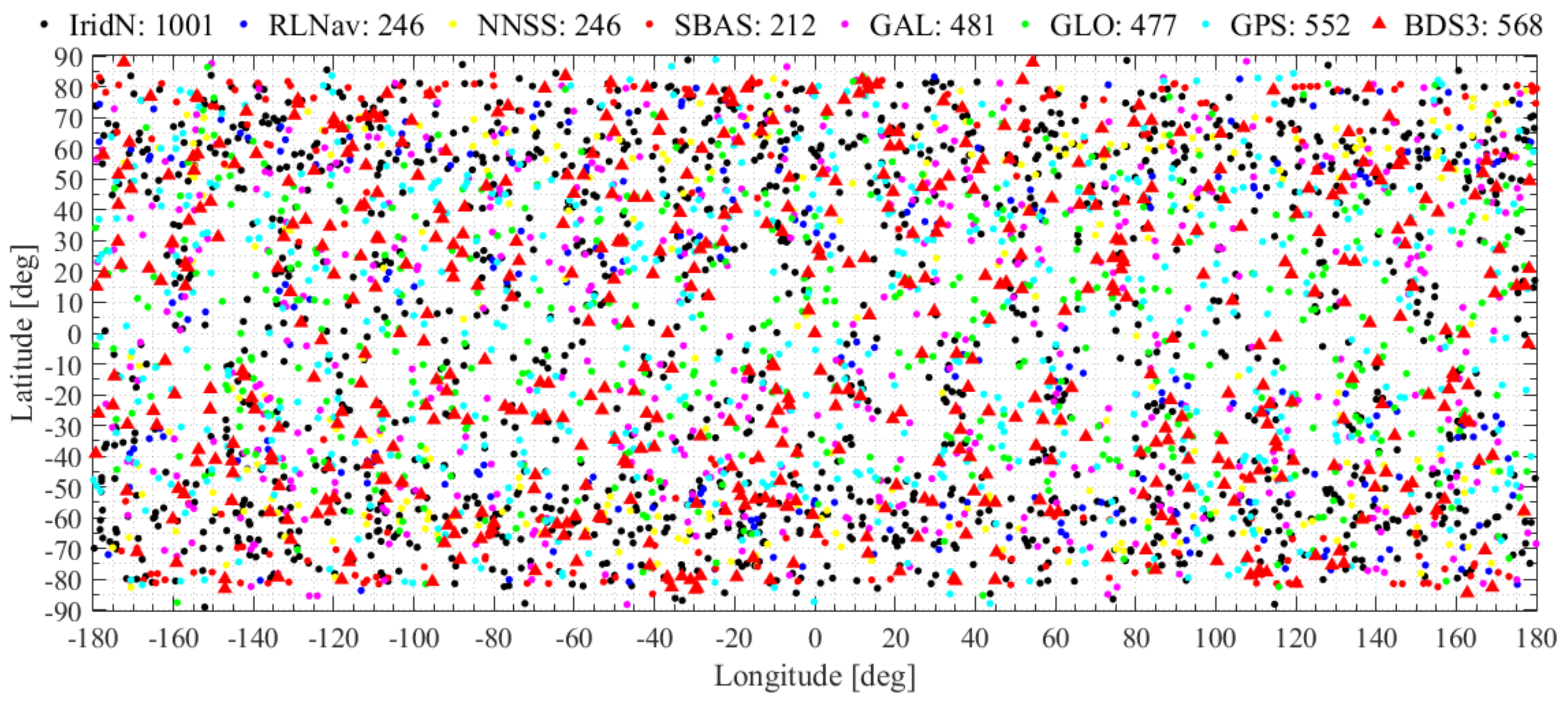
2.3. GNSS and LEO Satellite Orbital Data

In this study, two-line element (TLE) format satellite orbital data were used for the GNSS RO event simulation. The GNSS satellites’ and Spire weather satellites’ orbital data were downloaded from the Current TLE (on 20 June 2021) via the link: https://www.celestrak.com/ (latest accessed date is 16 December 2021). A multi-GNSS TS system involves GPS Operational (30 satellites), GLONASS Operational (GLO, 27 satellites), GALILEO (GAL, 26 satellites), BDS (50 satellites), satellite-based augmentation system (SBAS, 16 satellites), navy navigation satellite system (NNSS, 18 satellites), and Russian LEO navigation (RLNav, 9 satellites), as well as the Iridium NEXT constellation (IridN, 75 satellites) which has satellite navigation, positioning, and timing functions. Therefore, the selected TS system had 251 satellites in total. Due to the large number of multi-GNSS TS satellites, the satellite ID and major orbital roots of representative TS satellites are given in Table 1.
In this study, the LEO RS satellites mainly involved 12 designed polar-orbit satellites, a traditional meteorological satellite (MET), and Spire weather satellites. Currently, there are 114 Spire weather satellites in orbit, and about 100 Spire weather satellites have been carrying GNSS RO sounders for atmospheric sounding since 2016; thus, 100 Spire weather satellites were selected to form a RO constellation as the control experimental group. The satellite ID and major orbital roots of the LEO RS satellites are shown in Table 2, in which three representative Spire weather satellites are presented.

2.4. Experimental Programs

Numerical simulation experiments of RO events were conducted by using the abovementioned TLE orbit data of the GNSS transmitting and LEO receiving satellites to quantitatively analyze the following scientific questions under the existing multi-GNSS conditions.
➀ To what extent can the multi-GNSS integration increase the number of RO events and their global coverage fraction for a single polar-orbit LEO satellite?
➁ An RO constellation with how many polar-orbit LEO satellites can achieve the Spire/GPS occultation detection capability and thus can meet the GNWP’s basic requirements in terms of the RO event number, timeliness, and global coverage fraction?
In the GNSS RO event simulation, the receiving satellites were divided into 6 groups, i.e., the single traditional meteorology LEO satellite (MET), 3-satellite constellation (RS01-03, 3RS), 6-satellite constellation (RS01-06, 6RS), 9-satellite constellation (RS01-09, 9RS), 12-satellite constellation (RS01-12, 12RS), and 100-satellite constellation (100RS), while the transmitting satellites were divided into 3 groups i.e., single GNSS systems of BDS-3 (30 satellites), GPS (30 satellites), and multi-GNSS (251 satellites). Then, GNSS RO systems combined with the abovementioned receiving and transmitting satellite groups were simulated, long time series of GNSS RO events were calculated by using the methods described in Section 2.1, and the ID number, latitude, longitude, and time of each RO event were stored in occultation tables for statistical analysis.
Specifically, the comparison of the MET/multi-GNSS and MET/BDS-3 RO system performance could be used to analyze the detection capability improvement of multi-GNSS for a single polar-orbit LEO satellite. The comparison of the 3RS/multi-GNSS, 6RS/multi-GNSS, 9RS/multi-GNSS, 12RS/multi-GNSS, and 100RS/GPS RO systems were used to analyze the detection capability of the polar-orbit LEO satellite constellations under the existing multi-GNSS status.

3. Results

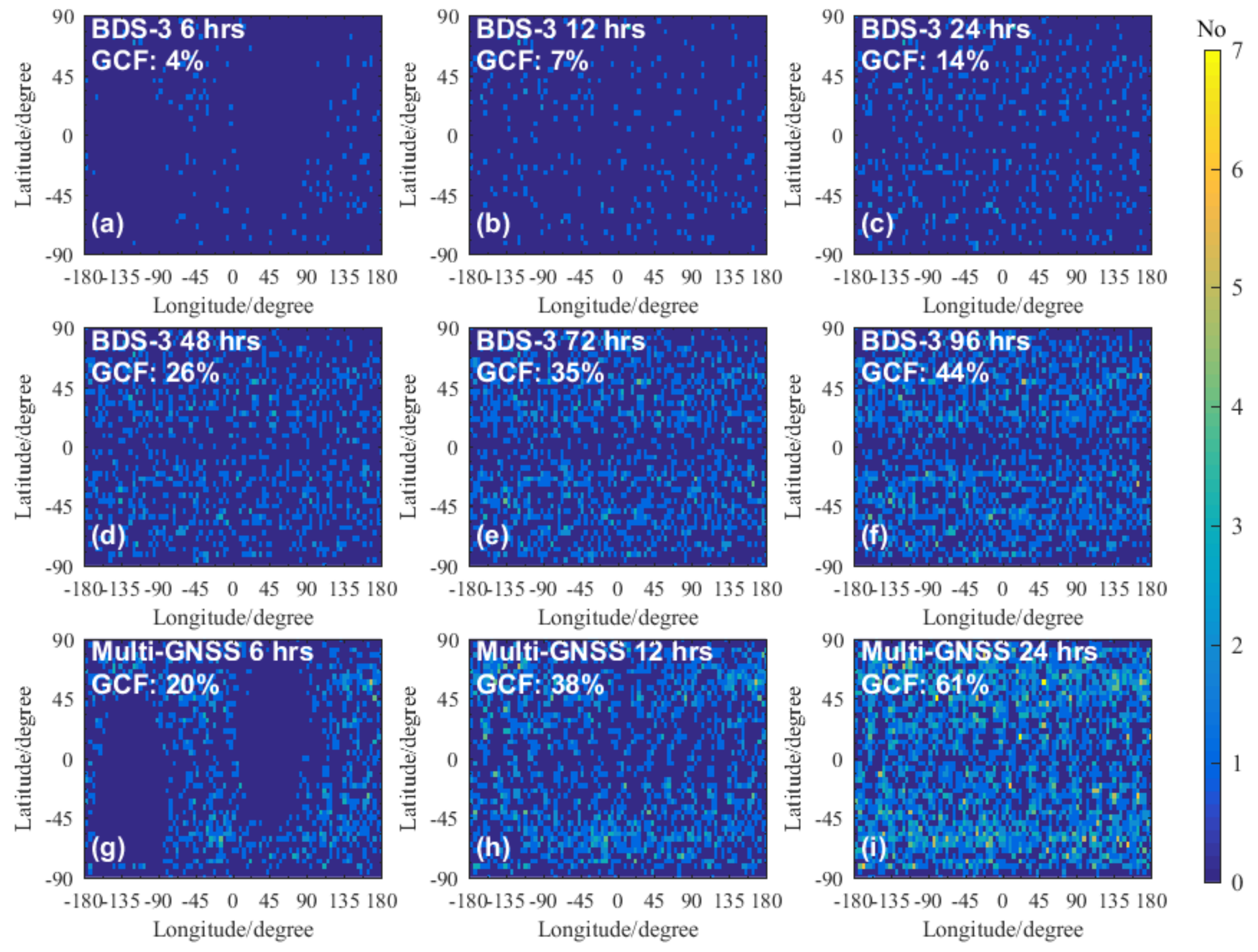
3.1. Detection Capability Improvement of Multi-GNSS for a Single Polar-Orbit Satellite

In order to analyze the RO detection capability enhancement of a single polar-orbit satellite by the multi-GNSS integration, the GNSS RO events in five days from 21 to 25 June 2021 were simulated using MET and multi-GNSS satellites’ orbital data. The global distribution of the MET/multi-GNSS RO events on 21 June 2021 is shown in Figure 2, in which the red triangles indicate MET/BDS-3 RO events, and the colorful dots indicate the RO events of different GNSS systems marked by the legends. From Figure 2, one can see that on 21 June 2021, there were 568 MET/BDS-3 RO events sparsely distributed on the Earth while there were 3783 MET/multi-GNSS RO events that occurred, and those RO events formed a more uniform and dense coverage of the Earth.
To quantitatively analyze the spatial and temporal distribution of each GNSS system RO event, the time series of GCF and UCI of the GNSS RO events were calculated by using the methods introduced in Section 2.2. However, the equal-area projection distorts the world map by angle and length, and the most serious distortion is in the polar regions. The world map distortion makes it difficult to plot the RO events’ global coverage using latitude and longitude coordinates. To show the RO events’ distribution in a common way and avoid the RO events being counted many times, Figure 3 shows the number of RO event revisits using a 4° × 4° latitude and longitude grid coordinate.
To further explore the RO detection capability improvement of the integration of multiple GNSS for a single polar-orbit LEO satellite quantitatively, Figure 3 and Figure 4 show the global coverage and the number trend beside the GCF trend of the occultation events for MET/BDS-3 and MET/multi-GNSS RO systems.
Figure 3a–f describe the global coverage situations of the MET/BDS-3 RO events that occurred in 6 h, 12 h, 24 h, 48 h, 72 h, and 96 h, respectively, while Figure 3g–i describe the global coverage situations of MET/multi-GNSS RO events that occurred in 6 h, 12 h, and 24 h, respectively. As shown in Figure 3, the GCF of RO events gradually increased with time accumulation, and the GCF values of MET/BDS-3 RO events that occurred in 6 h, 12 h, 24 h, 48 h, 72 h, and 96 h were 4%, 7%, 14%, 26%, 35%, and 44%, respectively, while the GCF values of the MET/multi-GNSS RO events that occurred in 6 h, 12 h, and 24 h were 20%, 38%, and 61%, respectively. Comparing the performance of the two RO systems, one can see that the GCF of MET/multi-GNSS RO events in 24 h was about four times that of the MET/BDS-3. Furthermore, the GCF of the MET/multi-GNSS RO events in 24 h was larger than that of MET/BDS-3 RO events in 96 h, and its maximum number of RO event revisits was also higher. However, as shown in Figure 3g, the GCF of 6 h MET/multi-GNSS RO events was only 20%, which could not meet the requirements of GNWP for RO data volume and timeliness.
There were two blank regions in the 6 h GNSS RO Figure 3a,g. These distinct performances of the GNSS RO event distribution and uniformity were caused by the limitations of the short time interval and LEO satellite number. The single meteorology LEO satellite’s orbital period was about 1.69 h, which means it can only run about 3.55 circles around the Earth in 6 h; therefore, its track could not cover the entire Earth’s surface in such a short time. Furthermore, the meteorology LEO satellite’s orbit track and velocity were along the longitude direction, and the GNSS RO events occurred in the fore and back occultation antenna fields of view; therefore, the GNSS RO events distributed along the longitude as shown in Figure 3a,g.
Figure 4 illustrates the occultation number trend beside the GCF trend of the MET/BDS-3 and MET/multi-GNSS RO systems. As shown in Figure 4, the occultation numbers were proportional to time, and their growth rates were about 540 and 4200 events per day, respectively, while the 5 day cumulative occultation numbers were about 2700 and 21,000, respectively. The GCF increased with time accumulation, and the 5 day cumulative occultation GCFs were about 52% and 99%, respectively. Therefore, the multi-GNSS integration could significantly increase the occultation number and GCF of a single polar-orbit LEO satellite. Specifically, the occultation number and the growth rate of the MET/multi-GNSS RO system were about 7.8 times as many as those of the MET/BDS-3 RO system.

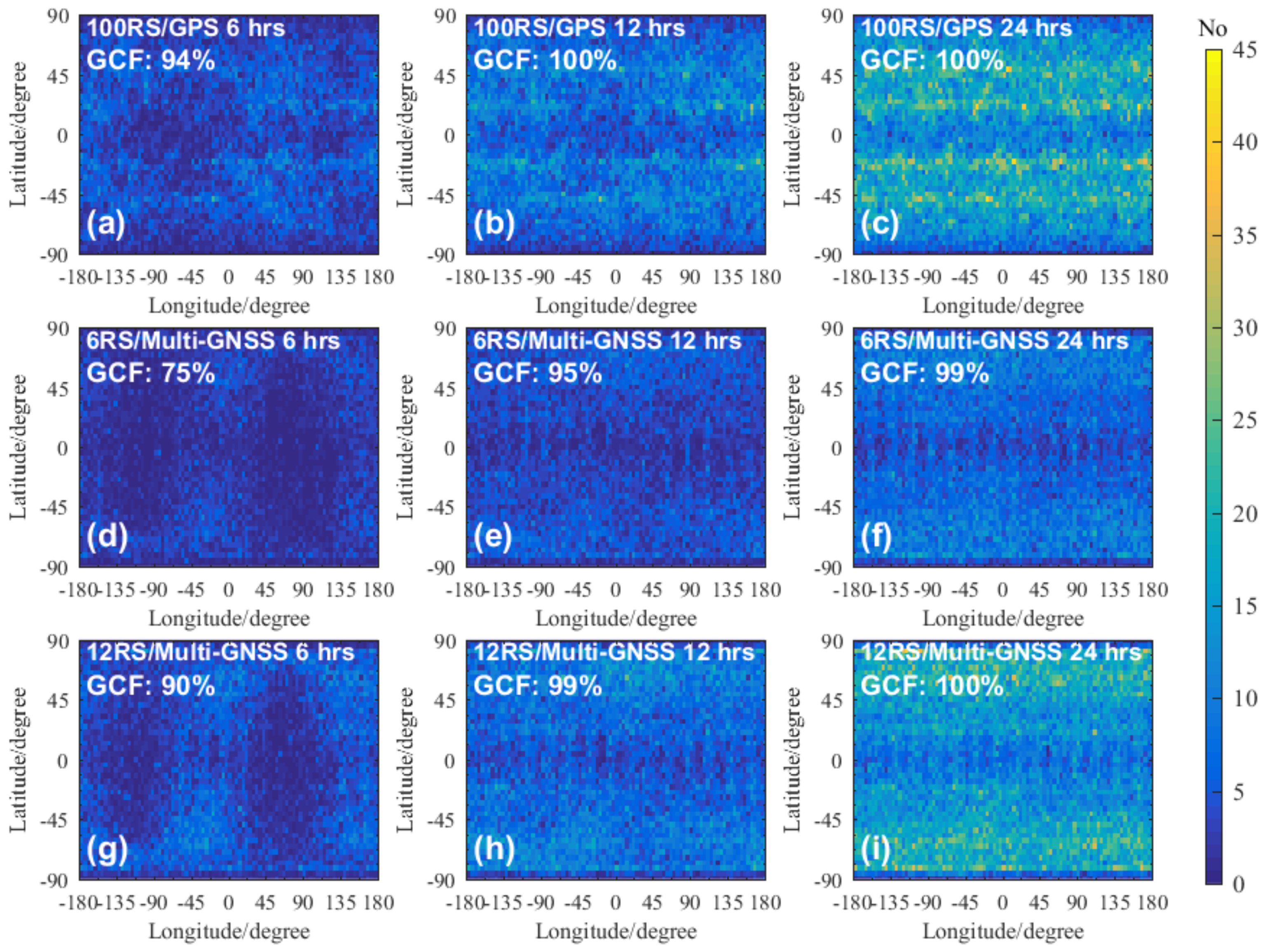
3.2. Comparing Polar-Orbit Constellation Detection Capability with the Spire Constellation
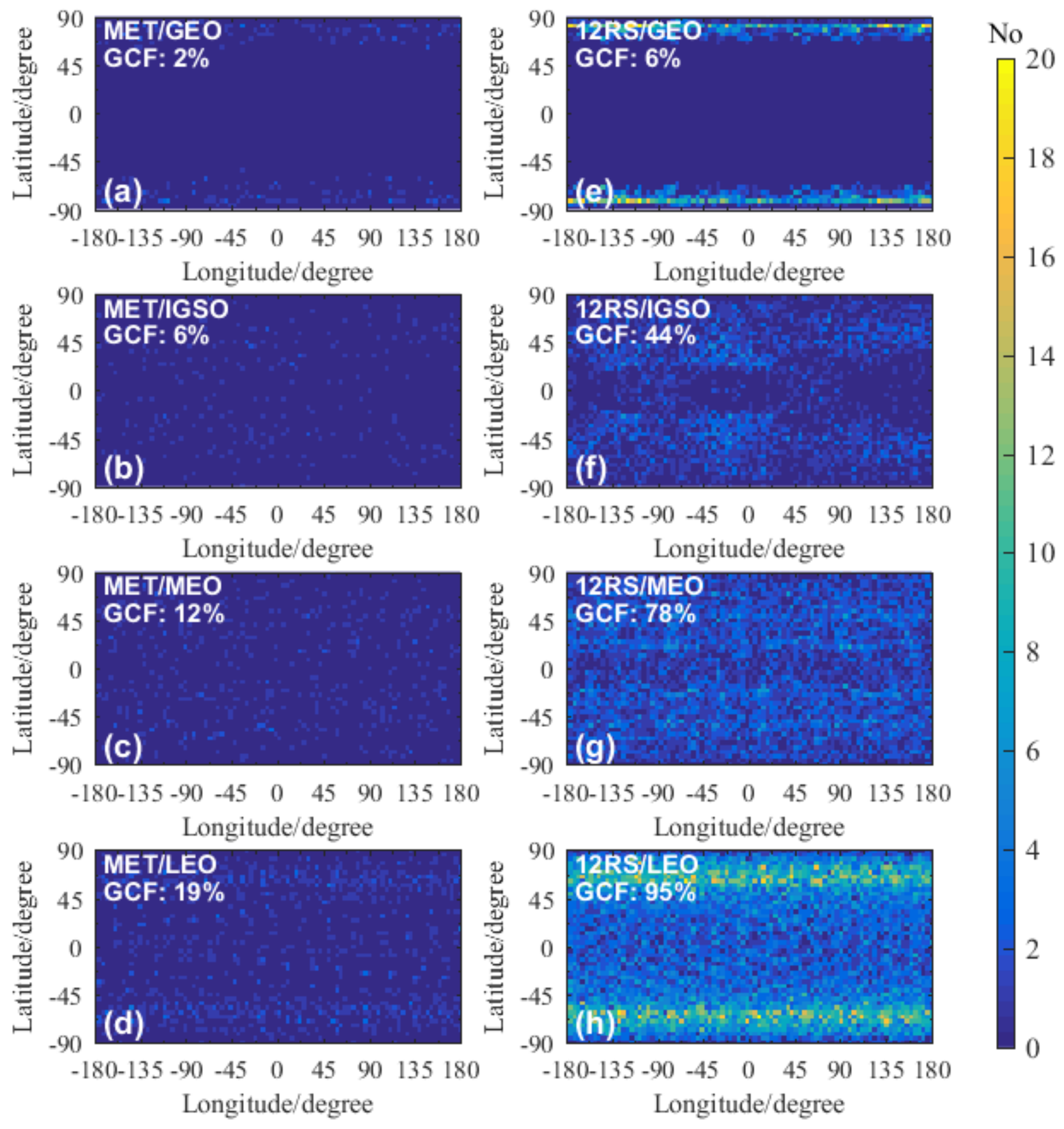
In order to explore the RO detection capabilities of the constellations with polar-orbit satellites and the Spire/GPS RO system including 100 Spire weather LEO satellites quantitatively, Figure 5 and Figure 6 show the global coverage and the number trend beside the GCF trend of the RO events for 100RS/GPS, 6RS/multi-GNSS, and 12RS/multi-GNSS constellations in 6 h, 12 h, and 24 h.
As shown in Figure 5a–c, the GCF value of the 100RS/GPS RO events in 6 h reached 94% and formed a uniform global coverage, which could basically meet the requirements of the RO number and timeliness for the GNWP for which products are released in every 6 h. The 12 h and 24 h 100RS/GPS RO events’ GCF values could reach 100%, and the number of RO event revisits for a single-grid cell in the mid-latitude zones could reach more than 40.
As shown in Figure 5d–f, the GCF values of 6RS/multi-GNSS RO events in 6 h, 12 h, and 24 h were 75%, 95%, and 99%, respectively, which were smaller than those of the 100RS/GPS system, and their global coverage uniformity was also poor compared with the 100RS/GPS system. Figure 5g–i show that the GCF values of the 12RS/multi-GNSS RO events in 6 h, 12 h, and 24 h were 90%, 99%, and 100%, respectively. Therefore, the 24 h GCF value of the 12RS/multi-GNSS RO events was comparable to the 100RS/GPS RO system. Regarding the number of the RO event revisits, the 12RS/multi-GNSS constellation performed higher in polar regions but lower in middle- and low-latitude zones than the 100RS/GPS RO system.
Figure 6 illustrates the occultation number trend beside the GCF trend of the RO events for 100RS/GPS, 3RS/multi-GNSS, 6RS/multi-GNSS, 9RS/multi-GNSS, and 12RS/multi-GNSS RO systems within 24 h. As shown in Figure 6, with the increase in the number of polar-orbit RS satellites, the slope of the occultation number and GCF curves increased significantly; particularly, the curves of 12RS/multi-GNSS and 100RS/GPS RO systems were similar to each other, and in some time intervals, the corresponding occultation number lines and GCF curves overlapped. This indicates that in the multi-GNSS combination scenario, the RO detection capability of RS constellation composed of 12 polar-orbit LEO satellites was basically comparable to that of the 100RS/GPS RO system. Specifically, both the 12RS/multi-GNSS and 100RS/GPS RO systems achieved a global coverage fraction of 100% in about 12 h, and the daily RO event numbers reached more than 60,000, which could meet the basic requirements of global numerical weather prediction for occultation data volume and timeliness.
Table 3 presents the RO events’ global coverage fraction UCI(1) and global coverage uniformity UCI(m) data for the seven RO detection systems in 6, 12, and 24 h. From Table 3, one can see that in the single RS satellite scenario compared with the MET/BDS-3 constellation, the multi-GNSS combination significantly improved the RO event global coverage and uniformity, but the performance was still poor. Even in the multi-GNSS combination scenario, the limitation of the single RS satellite in terms of the RO event spatial and temporal distribution was obvious, which could not meet the requirements of the global numerical weather prediction and climate research.
In the multi-GNSS combination scenario, when the number of the RS satellites increased from one to three, the UCI(1) and UCI(m) indices increased significantly. With the RS satellite number increase, the UCI(1) parameter increased monotonously, but the UCI(m) parameter showed a gradual decreasing trend with fluctuations. The UCI(1) parameter of the 12RS/multi-GNSS system was comparable to that of the 100RS/GPS RO system; however, the UCI(m) parameter of 12RS/multi-GNSS was smaller than that of the 100RS/GPS RO system. This indicates that although the global coverage fraction of 12RS/multi-GNSS RO events basically reached the level of 100RS/GPS RO system, the global uniformity of the 12RS/multi-GNSS system was worse than that of the 100RS/GPS RO system.
In summary, in the multi-GNSS combination scenario, the occultation constellation composed of polar-orbit RS satellites, with the increase in the number of RS satellites, the number and GCF values of RO events increased significantly. When the number of RS satellites increased to 12, the RO detection capability of the RS12/multi-GNSS RO system could reach that of the 100RS/GPS RO system; specifically, the 24 h RO events GCF could reach 100%, and the global coverage uniformity could reach more than 40%, which could meet the basic requirements of global numerical weather prediction in terms of the RO event number, timeliness, and global coverage fraction.

4. Discussion

From the results, one can see that the number and GCF of the 12RS/multi-GNSS RO events basically reached the level of the Spire/GPS RO system. However, the global coverage uniformity of the 12RS/multi-GNSS RO events was worse. As shown in Figure 5, compared with the Spire/GPS constellation, the number of the RO event revisits of the 12RS/multi-GNSS RO events was smaller at low latitudes and larger at high latitudes.
To investigate the RO event distribution characteristics of the polar-orbit RS constellations in the multi-GNSS combination scenario, all high-orbit TS satellites (i.e., Geosynchronous Orbit (GEO) and Inclined Geosynchronous Orbit (IGSO) satellites) from the existing GNSS satellites, the MEO (Medium Earth Orbit) satellites from the BDS-3 constellation, and the Iridium NEXT constellation were selected to represent the high-orbit, medium-orbit, and low-orbit TS satellites, respectively, for a 24 h RO event simulation analysis. The occultation events’ global coverage and GCF values for eight representative RO systems of MET/GEO, MET/IGSO, MET/MEO, MET/LEO, 12RS/GEO, 12RS/IGSO, 12RS/MEO, and 12RS/LEO are given in Figure 7.
As shown in Figure 7, the polar-orbit RS/GEO RO events were mainly distributed in the polar regions, increasing the number of RO event revisits in these regions; however, there were almost no RO events located in the middle- and low-latitudes zones (i.e., the area between ±60°). Therefore, the polar-orbit RS/GEO RO events were beneficial to the climate change monitoring in the polar regions. The polar-orbit RS/IGSO RO events were unevenly distributed in both latitudinal and longitudinal directions, with more events occurring at middle- and high-latitude regions. The global distribution of polar-orbit RS/MEO RO events was more uniform. The polar-orbit RS/LEO RO events could cover the Earth globally, and there were more RO events in high-latitude areas than in middle- and low-latitude areas. Therefore, a constellation with polar-orbit RS satellites could form a global RO event coverage and was more beneficial for middle- and high-latitude region atmospheric monitoring.
In this paper, we analyzed the detection capabilities of all abovementioned GNSS RO systems for the occultation event number and their spatiotemporal distribution level, which represent the maximum detection capability of those RO systems. Practically, not all the GNSS RO events’ atmospheric products can be retrieved from the raw RO observation data successfully with high precision; thus, the low quality and even failure of the RO products retrieval can somehow reduce the RO systems detection capabilities for GCM and GNWP applications. The GNSS RO retrieval and quality control were not the focus of this study, and it may be investigated in our future work.

5. Conclusions

The improvement of the number and global coverage fraction of RO events for a single polar-orbit RS satellite by the multi-GNSS integration, as well as the RO detection capability of the polar-orbit satellite constellations under the conditions of the existing multi-GNSS were quantitatively analyzed. The main conclusions were as follows.
For a polar-orbit RS satellite, compared with the BDS-3, the multi-GNSS integration increased the number of RO events and their growth rate by 6.8 times while increasing the 24 h and 5 day RO events’ GCF values by 3 times and 1 time, respectively.
In the multi-GNSS scenario, the RS constellation of 12 polar-orbit satellites could reach the detection capability of the Spire/GPS RO system, and the global coverage fraction of 24 h RO events could reach 100% while the global coverage uniformity could reach 44%, which could meet the basic requirements of global numerical weather prediction in terms of the RO event number, timeliness, and global coverage fraction.
The RO events of polar-orbit RS satellites and constellations with GEO, IGSO, and LEO navigation satellites as TS systems contributed more to the coverage in the middle- and high-latitude regions; thus, they were beneficial to the atmospheric sounding in middle-latitude and polar regions.
According to the requirements of global numerical weather prediction and climate monitoring, a simulation study on the effect of multiple GNSS integration on the number, global coverage fraction, and uniformity of RO events was conducted. In this study, polar-orbit satellites and constellations were designed, and 100 Spire weather satellites were selected to form the receiving satellite systems, in addition to the GNSS, regional navigation satellite system, and Iridium NEXT constellations that were selected to form the multi-GNSS transmitting satellite systems. The assessment approaches and quantitative results were significant to provide references for the design of GNSS RO constellations, receivers, and satellite platforms in the multiple GNSS scenario.

Author Contributions

Conceptualization, C.L., Y.S. and W.B.; methodology, C.L., Q.D. and W.B.; software, C.L.; validation, C.L.; formal analysis, C.L.; investigation, C.L. and W.B.; resources, Y.S. and C.L.; writing—original draft preparation, C.L.; writing—review and editing, X.W. and P.L.; reviewing X.W. and P.L.; visualization, C.L. and W.L.; supervision, Y.S. and Q.D.; project administration, C.L., W.L., W.B., Q.D. and Y.S. All authors have read and agreed to the published version of the manuscript.

Funding

This research was partially funded by the Youth Innovation Promotion Association of the Chinese Academy of Sciences (grant no. 2019151), the Strategic Priority Research Program of Chinese Academy of Sciences (grant no. XDA15021002), the National Natural Science Foundation of China (grant nos. 42074042, 41775034, 41405039 and 41606206), the Youth Talents Program Foundation of Beijing Organization Department (grant no. 2018000097607G380), the Youth Cross Team Scientific Research Project of the Chinese Academy of Sciences (grant no. JCTD-2021-10) and the FengYun-3 (FY-3) Global Navigation Satellite System Occultation Sounder (GNOS) development and manufacture project led by NSSC, CAS.

Institutional Review Board Statement

Not applicable.

Informed Consent Statement

Not applicable.

Data Availability Statement

Not applicable.

Acknowledgments

The authors thank Gottfried Kirchengast, Veronika Proschek, and Marc Schwaerz (WEGC/University of Graz, Austria) for valuable discussions and support in the occultation event simulation approaches used in this study, as well as the website https://www.celestrak.com/ (accessed on 19 May 2021) for providing TLE track data.

Conflicts of Interest

The authors declare no conflict of interest.

References

  1. Melbourne, W.G.; Davis, E.S.; Duncan, C.B.; Hajj, G.A.; Hardy, K.R.; Kursinski, E.R.; Meehan, T.K.; Yong, L.E.; Yunck, T.P. The Application of Spaceborne GPS to Atmospheric Limb Sounding and Global Change Monitoring; Jet Propulsion Laboratory: Pasadena, CA, USA, 1994. [Google Scholar]
  2. Kursinski, E.R.; Hajj, G.A.; Bertiger, W.I.; Leroy, S.S.; Meehan, T.K.; Romans, L.J.; Schofield, J.T.; McCleese, D.J.; Melbourne, W.G.; Thornton, C.L.; et al. Initial results of radio occultation observations of Earth’s atmosphere using the global positioning system. Science 1996, 271, 1107–1110. [Google Scholar] [CrossRef]
  3. Kursinski, E.R.; Hajj, G.A.; Schofield, J.T.; Linfield, R.P.; Hardy, K.R. Observing Earth’s atmosphere with radio occultation measurements using the Global Positioning System. J. Geophys. Res. 1997, 102, 23429–23465. [Google Scholar] [CrossRef]
  4. Steiner, A.K.; Kirchengast, G.; Foelsche, U.; Kornblueh, L.; Manzini, E.; Bengtsson, L. GNSS occultation sounding for climate monitoring. Phys. Chem. Earth Part A Solid Earth Geod. 2001, 26, 113–124. [Google Scholar] [CrossRef]
  5. Hajj, G.A.; Kursinski, E.R.; Romans, L.J.; Bertiger, W.I.; Leroy, S.S. A technical description of atmospheric sounding by GPS occultation. J. Atmos. Sol. -Terr. Phys. 2002, 64, 451–469. [Google Scholar] [CrossRef]
  6. Liu, C.; Kirchengast, G.; Syndergaard, S.; Schwaerz, M.; Danzer, J.; Sun, Y. New Higher-Order Correction of GNSS RO Bending Angles Accounting for Ionospheric Asymmetry: Evaluation of Performance and Added Value. Remote Sens. 2020, 12, 3637. [Google Scholar] [CrossRef]
  7. Gleisner, H.; Lauritsen, K.B.; Nielsen, J.K.; Syndergaard, S. Evaluation of the 15-year ROM SAF monthly mean GPS radio occultation climate data record. Atmos. Meas. Tech. 2020, 13, 3081–3098. [Google Scholar] [CrossRef]
  8. Stocker, M.; Ladstadter, F.; Wilhelmsen, H.; Steiner, A.K. Quantifying Stratospheric Temperature Signals and Climate Imprints From Post-2000 Volcanic Eruptions. Geophys Res Lett 2019, 46, 12486–12494. [Google Scholar] [CrossRef] [Green Version]
  9. Ladstädter, F.; Steiner, A.K.; Schwärz, M.; Kirchengast, G. Climate intercomparison of GPS radio occultation, RS90/92 radiosondes and GRUAN from 2002 to 2013. Atmos. Meas. Tech. 2015, 8, 1819–1834. [Google Scholar] [CrossRef] [Green Version]
  10. Steiner, A.K.; Hunt, D.; Ho, S.P.; Kirchengast, G.; Mannucci, A.J.; Scherllin-Pirscher, B.; Gleisner, H.; von Engeln, A.; Schmidt, T.; Ao, C.; et al. Quantification of structural uncertainty in climate data records from GPS radio occultation. Atmos. Chem. Phys. 2013, 13, 1469–1484. [Google Scholar] [CrossRef] [Green Version]
  11. Ho, S.-p.; Hunt, D.; Steiner, A.K.; Mannucci, A.J.; Kirchengast, G.; Gleisner, H.; Heise, S.; von Engeln, A.; Marquardt, C.; Sokolovskiy, S.; et al. Reproducibility of GPS radio occultation data for climate monitoring: Profile-to-profile inter-comparison of CHAMP climate records 2002 to 2008 from six data centers. J. Geophys. Res. Atmos. 2012, 117, D18111. [Google Scholar] [CrossRef]
  12. Ao, C.O.; Mannucci, A.J.; Kursinski, E.R. Improving GPS Radio occultation stratospheric refractivity retrievals for climate benchmarking. Geophys. Res. Lett. 2012, 39, 229–240. [Google Scholar] [CrossRef]
  13. Lackner, B.C.; Steiner, A.K.; Hegerl, G.C.; Kirchengast, G. Atmospheric climate change detection by radio occultation data using a fingerprinting method. J. Clim. 2011, 24, 5275–5291. [Google Scholar] [CrossRef] [Green Version]
  14. Kirchengast, G.; Schweitzer, S. Climate benchmark profiling of greenhouse gases and thermodynamic structure and wind from space. Geophys. Res. Lett. 2011, 38, 142–154. [Google Scholar] [CrossRef]
  15. Foelsche, U.; Scherllin-Pirscher, B.; Ladstädter, F.; Steiner, A.K.; Kirchengast, G. Refractivity and temperature climate records from multiple radio occultation satellites consistent within 0.05%. Atmos. Meas. Tech. 2011, 4, 2007–2018. [Google Scholar] [CrossRef] [Green Version]
  16. Anthes, R.A. Exploring Earth’s atmosphere with radio occultation: Contributions to weather, climate and space weather. Atmos. Meas. Tech. 2011, 4, 1077–1103. [Google Scholar] [CrossRef] [Green Version]
  17. Ho, S.-p.; Kirchengast, G.; Leroy, S.; Wickert, J.; Mannucci, A.J.; Steiner, A.; Hunt, D.; Schreiner, W.; Sokolovskiy, S.; Ao, C.; et al. Estimating the uncertainty of using GPS radio occultation data for climate monitoring: Intercomparison of CHAMP refractivity climate records from 2002 to 2006 from different data centers. J. Geophys. Res. 2009, 114, 1470–1478. [Google Scholar] [CrossRef] [Green Version]
  18. Foelsche, U.; Pirscher, B.; Borsche, M.; Kirchengast, G.; Wickert, J. Assessing the climate monitoring utility of radio occultation data: From CHAMP to FORMOSAT-3/COSMIC. Terr. Atmos. Ocean. Sci. 2009, 20, 155–170. [Google Scholar] [CrossRef] [Green Version]
  19. Gobiet, A.; Kirchengast, G.; Manney, G.L.; Borsche, M.; Retscher, C.; Stiller, G. Retrieval of temperature profiles from CHAMP for climate monitoring: Intercomparison with Envisat MIPAS and GOMOS and different atmospheric analyses. Atmos. Chem. Phys. 2007, 7, 3519–3536. [Google Scholar] [CrossRef] [Green Version]
  20. Gobiet, A.; Kirchengast, G. Advancements of Global Navigation Satellite System radio occultation retrieval in the upper stratosphere for optimal climate monitoring utility. J. Geophys. Res. 2004, 109, 1. [Google Scholar] [CrossRef] [Green Version]
  21. Foelsche, U.; Kirchengast, G.; Steiner, A.K. Global Climate Monitoring based on CHAMP/GPS Radio Occultation Data. In First CHAMP Mission Results for Gravity, Magnetic and Atmospheric Studies; Springer: Berlin/Heidelberg, Germany, 2003; pp. 397–407. [Google Scholar]
  22. Kursinski, E.R.; Ward, D.; Otarola, A.C.; McGhee, J.; Stovern, M.; Sammler, K.; Reed, H.; Erickson, D.; McCormick, C.; Griggs, E. Atmospheric profiling via satellite to satellite occultations near water and ozone absorption lines for weather and climate. In Earth Observing Missions and Sensors: Development, Implementation, and Characterization IV; SPIE: Bellingham, WA, USA, 2016; Volume 9881, pp. 140–159. [Google Scholar]
  23. Cook, K.; Chen-Joe, F.; Wenkel, M.J.; Wilczynski, P.; Yen, N.; Chang, G.S. COSMIC-2/FORMOSAT-7: The future of global weather monitoring and prediction. In Proceedings of the 2015 IEEE Aerospace Conference, Big Sky, MT, USA, 7–14 March 2015; IEEE: Piscataway, NJ, USA, 2015. [Google Scholar]
  24. Aparicio, J.M.; Laroche, S. Estimation of the Added Value of the Absolute Calibration of GPS Radio Occultation Data for Numerical Weather Prediction. Mon. Weather Rev. 2015, 143, 1259–1274. [Google Scholar] [CrossRef]
  25. Cucurull, L.; Anthes, R.A.; Tsao, L.L. Radio Occultation Observations as Anchor Observations in Numerical Weather Prediction Models and Associated Reduction of Bias Corrections in Microwave and Infrared Satellite Observations. J. Atmos. Ocean. Technol. 2014, 31, 20–32. [Google Scholar] [CrossRef]
  26. Cucurull, L.; Anthes, R.A. Impact of Infrared, Microwave, and Radio Occultation Satellite Observations on Operational Numerical Weather Prediction. Mon. Weather Rev. 2014, 142, 4164–4186. [Google Scholar] [CrossRef] [Green Version]
  27. Cucurull, L.; Kuo, Y.H.; Barker, D.; Rizvi, S.R.H. Assessing the Impact of Simulated COSMIC GPS Radio Occultation Data on Weather Analysis over the Antarctic: A Case Study. Mon. Weather Rev. 2006, 134, 3283–3296. [Google Scholar] [CrossRef]
  28. Steiner, A.K.; Kirchengast, G.; Ladreiter, H.-P. Inversion, error analysis, and validation of GPS/MET occultaiton data. In Annales Geophysicae; Springer: Berlin/Heidelberg, Germany, 1999; pp. 122–138. [Google Scholar]
  29. Wickert, J.; Schmidt, T.; Michalak, G.; Heise, S.; Arras, C.; Beyerle, G.; Falck, C.; König, R.; Pingel, D.; Rothacher, M. GPS Radio Occultation with CHAMP, GRACE-A, SAC-C, TerraSAR-X, and FORMOSAT-3/COSMIC: Brief Review of Results from GFZ. In New Horizons in Occultation Research; Springer: Berlin/Heidelberg, Germany, 2009; pp. 3–15. [Google Scholar]
  30. Gobiet, A.; Foelsche, U.; Steiner, A.K.; Borsche, M.; Kirchengast, G.; Wickert, J. Climatological validation of stratospheric temperatures in ECMWF operational analyses with CHAMP radio occultation data. Geophys. Res. Lett. 2005, 32, 161–179. [Google Scholar] [CrossRef] [Green Version]
  31. Wickert, J.; Reigber, C.; Beyerle, G.; Konig, R.; Marquardt, C.; Schmidt, T.; Grunwaldt, L.; Galas, R.; Meehan, T.K.; Melbourne, W.G.; et al. Atmosphere sounding by GPS radio occultation: First results from CHAMP. Geophys. Res. Lett. 2001, 28, 3263–3266. [Google Scholar] [CrossRef] [Green Version]
  32. Beyerle, G. GPS radio occultation with GRACE: Atmospheric profiling utilizing the zero difference technique. Geophys. Res. Lett. 2005, 32, L13806. [Google Scholar] [CrossRef] [Green Version]
  33. Luntama, J.P.; Kirchengast, G.; Borsche, M.; Foelsche, U.; Steiner, A.; Healy, S.; von Engeln, A.; O’Clerigh, E.; Marquardt, C. Prospects of the Eps Gras Mission for Operational Atmospheric Applications. Bull. Am. Meteorol. Soc. 2008, 89, 1863. [Google Scholar] [CrossRef] [Green Version]
  34. Anthes, R.A.; Ector, D.; Hunt, D.C.; Kuo, Y.H.; Rocken, C.; Schreiner, W.S.; Sokolovskiy, S.V.; Syndergaard, S.; Wee, T.K.; Zeng, Z.; et al. The COSMIC/FORMOSAT-3 Mission: Early Results. Bull. Am. Meteorol. Soc. 2008, 89, 313–333. [Google Scholar] [CrossRef]
  35. Schreiner, W.; Rocken, C.; Sokolovskiy, S.; Syndergaard, S.; Hunt, D. Estimates of the precision of GPS radio occultations from the COSMIC/FORMOSAT-3 mission. Geophys. Res. Lett. 2007, 34, 545–559. [Google Scholar] [CrossRef] [Green Version]
  36. Sun, Y.Q.; Bai, W.H.; Liu, C.L.; Liu, Y.; Du, Q.F.; Wang, X.Y.; Yang, G.L.; Liao, M.; Yang, Z.D.; Zhang, X.X.; et al. The FengYun-3C radio occultation sounder GNOS: A review of the mission and its early results and science applications. Atmos. Meas. Tech. 2018, 11, 5797–5811. [Google Scholar] [CrossRef] [Green Version]
  37. Bai, W.H.; Liu, C.L.; Meng, X.G.; Sun, Y.Q.; Kirchengast, G.; Du, Q.F.; Wang, X.Y.; Yang, G.L.; Liao, M.; Yang, Z.D.; et al. Evaluation of atmospheric profiles derived from single- and zero-difference excess phase processing of BeiDou radio occultation data from the FY-3C GNOS mission. Atmos. Meas. Tech. 2018, 11, 819–833. [Google Scholar] [CrossRef] [Green Version]
  38. Liao, M.; Zhang, P.; Yang, G.-L.; Bi, Y.-M.; Liu, Y.; Bai, W.-H.; Meng, X.-G.; Du, Q.-F.; Sun, Y.-Q. Preliminary validation of the refractivity from the new radio occultation sounder GNOS/FY-3C. Atmos. Meas. Tech. 2016, 9, 781–792. [Google Scholar] [CrossRef] [Green Version]
  39. Adhikari, L.; Ho, S.-P.; Zhou, X. Inverting COSMIC-2 Phase Data to Bending Angle and Refractivity Profiles Using the Full Spectrum Inversion Method. Remote Sens. 2021, 13, 1793. [Google Scholar] [CrossRef]
  40. Wang, L.; Li, D.R.; Chen, R.Z.; Fu, W.J.; Shen, X.; Jiang, H. Low Earth Orbiter (LEO) Navigation Augmentation: Opportunities and Challenges. Eng. Sci. 2020, 22, 144–152. [Google Scholar]
  41. Wang, S.Z.; Liu, C.L.; Zhu, G.W.; Bai, W.H.; Du, Q.F.; Sun, Y.Q.; Xia, J.M.; Meng, X.G.; Wang, X.Y.; Zhao, D.Y.; et al. Simulation Study on GRO and LRO Events. Chin. J. Space Sci. 2017, 37, 207–213. [Google Scholar]
  42. Wang, S.Z.; Zhu, G.W.; Bai, W.H.; Liu, C.L.; Sun, Y.Q.; Du, Q.F.; Wang, X.Y.; Meng, X.G.; Yang, G.L.; Yang, Z.D.; et al. For the first time fengyun3 C satellite-global navigation satellite system occultation sounder achieved spaceborne Bei Dou system radio occultation. Acta Phys. Sin. 2015, 64, 408–415. [Google Scholar]
  43. Wang, X.Y.; Sun, Y.Q.; Bai, W.H.; Du, Q.F.; Wang, D.W.; Wu, D.; Yu, Q.L.; Han, Y. Simulation of Numver and Distribution of Compass Occultation Events. Chin. J. Geophys. 2013, 56, 2522–2530. [Google Scholar]
  44. Zhang, X.H.; Ma, F.J. Review of the Development of LEO Navigation Augmented GNSS. Acta Geod. Cartogr. Sin. 2019, 48, 1073–1087. [Google Scholar]
  45. Harnisch, F.; Healy, S.B.; Bauer, P.; English, S.J. Scaling of GNSS Radio Occultation Impact with Observation Number Using an Ensemble of Data Assimilations. Mon. Weather Rev. 2013, 141, 4395–4413. [Google Scholar] [CrossRef]
  46. Steiner, A.K.; Ladstädter, F.; Ao, C.O.; Gleisner, H.; Ho, S.-P.; Hunt, D.; Schmidt, T.; Foelsche, U.; Kirchengast, G.; Kuo, Y.-H.; et al. Consistency and structural uncertainty of multi-mission GPS radio occultation records. Atmos. Meas. Tech. 2020, 13, 2547–2575. [Google Scholar] [CrossRef]
  47. Wang, J.Y.; Fu, Y.; Bai, W.H.; Wei, S.L.; Guo, B.B.; Yan, F.; Xie, C.Q. Design of GNSS Remotesening Satellite Constellation. Chin. J. Space Sci. 2021, 41, 475–482. [Google Scholar] [CrossRef]
  48. Liang, B.; Wang, J.Y.; Li, C.; Wei, S.L. Design of Multi-GNSS Occultation Sounding Satellite Constellation. J. Astronaut. 2016, 37, 334–340. [Google Scholar]
  49. Liang, B.; Wang, J.Y. Research on the Multi-Constellation Design for GNSS RO Atmosphere Sounding. Navig. Position. Timing 2016, 3, 58–64. [Google Scholar]
  50. Xu, X.H.; Li, Z.H.; Luo, J. Simulation Research on the Impact of LEO Constellation’s Parameters on the Number and Space-time Distribution of GPS Occultation Events. Acta Geod. Cartogr. Sin. 2015, 4, 27–33. [Google Scholar]
  51. Xu, X.H.; Li, Z.H.; Luo, J. Simulation of the Impacts of Single LEO Satellite Orbit Parameters on the Distribution and Number of Occultation Events. Geomat. Inf. Sci. Wuhan Univ. 2015, 7, 609–612. [Google Scholar]
  52. Mousa, A.; Aoyama, Y.; Tsuda, T. A simulation analysis to optimize orbits for a tropical GPS radio occultation mission. Earth Planets Space 2006, 58, 919–925. [Google Scholar] [CrossRef] [Green Version]
  53. Zhao, S.J.; Sun, X.J.; Zhu, Y.C.; Liao, F.Y. Effect of LEO Satellite’s Orbit Parameter on GPS Occultation Event’s Number and Distribution. J. PLA Univ. Sci. Technol. (Nat. Sci. Ed.) 2002, 2, 85–89. [Google Scholar]
  54. Asgarimehr, M.; Hossainali, M.M. GPS radio occultation constellation design with the optimal performance in Asia Pacific region. J. Geod. 2015, 89, 519–536. [Google Scholar] [CrossRef]
  55. Ghoniem, I.F.; Mousa, A.E.-K.; El-Fiky, G. GNSS-RO LEO satellite orbit optimization for Egypt and the Middle East region. Alex. Eng. J. 2020, 59, 389–397. [Google Scholar] [CrossRef]
  56. Ghoniem, I.; Mousa, A.E.-K.; El-Fiky, G. Distribution of the GNSS-LEO occultation events over Egypt. NRIAG J. Astron. Geophys. 2019, 6, 97–103. [Google Scholar] [CrossRef]
  57. Juang, J.-C.; Tsai, Y.-F.; Chu, C.-H. On constellation design of multi-GNSS radio occultation mission. Acta Astronaut. 2013, 82, 88–94. [Google Scholar] [CrossRef]
  58. Xu, X.; Han, Y.; Luo, J.; Wickert, J.; Asgarimehr, M. Seeking Optimal GNSS Radio Occultation Constellations Using Evolutionary Algorithms. Remote Sens. 2019, 11, 571. [Google Scholar] [CrossRef] [Green Version]
  59. Brodzik, M.J.; Billingsley, B.; Haran, T.; Raup, B.; Savoie, M.H. EASE-Grid 2.0: Incremental but Significant Improvements for Earth-Gridded Data Sets. ISPRS Int. J. Geo-Inf. 2012, 1, 32–45. [Google Scholar] [CrossRef] [Green Version]
  60. Liu, C.; Kirchengast, G.; Sun, Y.; Proschek, V.; Wang, X.; Tian, L.; Du, Q.; Bai, W.; Wu, C.; Hu, P.; et al. Impacts of Orbital and Constellation Parameters on the Number and Spatiotemporal Coverage of LEO-LEO Occultation Events. Remote Sens. 2021, 13, 4849. [Google Scholar] [CrossRef]
  61. Vallado, D.; Crawford, P.; Hujsak, R.; Kelso, T. Revisiting Spacetrack Report #3. In Proceedings of the AIAA/AAS Astrodynamics Specialist Conference and Exhibit, Keystone, CO, USA, 21–24 August 2006; American Institute of Aeronautics and Astronautics: Reston, VA, USA, 2006; Volume 6753, pp. 1–88. [Google Scholar]
  62. Du, X.-Y.; Fu, Y.; Xue, Z.-G.; Guo, Y.-N.; Mao, J.-T. Simulation of the Impacts of Satellite Orbit Parameters on the Number and Distribution of LEO-LEO Occultation Events. Chin. J. Geophys. 2007, 50, 1107–1116. [Google Scholar] [CrossRef]
Figure 1. Occultation geometry between one GNSS transmitting satellite (TS) and one LEO receiving satellite (RS).
Atmosphere 13 00654 g001
Figure 2. Distribution of the MET/multi−GNSS RO events on 21 June 2021.
Atmosphere 13 00654 g002
Figure 3. The global coverage of GNSS RO events for MET/BDS−3 and MET/multi−GNSS RO systems, illustrating the number of RO event revisits using a 4° × 4° latitude and longitude grid coordinate.
Atmosphere 13 00654 g003
Figure 4. GNSS RO number and global coverage fraction trend for MET/BDS−3 and MET/multi−GNSS RO systems.
Atmosphere 13 00654 g004
Figure 5. The global coverage of GNSS RO events for 100RS/GPS, 6RS/multi−GNSS and 12RS/multi−GNSS RO systems, illustrating the number of RO event revisits using a 4° × 4° latitude and longitude grid coordinate.
Atmosphere 13 00654 g005
Figure 6. Occultation number and global coverage fraction trend of 100RS/GPS and polar-orbit RS constellation/multi−GNSS RO events.
Atmosphere 13 00654 g006
Figure 7. The global coverage of GNSS RO events for MET/GEO/IGSO/MEO/LEO and 12RS/GEO/IGSO/MEO/LEO RO systems, illustrating the number of RO event revisits using a 4° × 4° latitude and longitude grid coordinate.
Atmosphere 13 00654 g007
Table 1. Main orbital elements of representative transmitting satellites from their TLE data files.
Satellite IDInclination/(°)RAAN/(°)EccentricityArgument of Perigee/(°)Mean Anomaly/(°)Height/(km)
BDS-3 (C59)1226.60.0003356.3149.435,787
BDS-3 (C38)5656.90.0019191.9341.835,787
BDS-3 (C19)55.4123.80.0012293.466.521,528
GPS (13)55.5169.80.004853.4307.120,182
COSMOS (2425)64.8255.30.0024342.916.319,129
GSAT (E11)56.831.20.000431.7328.323,222
IRIDIUM (109)86.4129.2092.1268.1778
COSMOS (2361)82.9112.90.0032129.843.7989
NNSS (19)89.9242.60.0171349.610.21069
QZSS (184)42.4269.30.0758269.189.635,787
QZSS (189)0.02188.60.0002271.7154.335,787
Table 2. Main orbital elements of the receiving satellites.
Satellite IDInclination/(°)RAAN/(°)EccentricityArgument of Perigee/(°)Mean Anomaly/(°)Height/(km)
RS0193.61510.00019030600
RS0293.92150.000190150600
RS0394.63300.000190270600
RS0495.51830.00019090600
RS0596.62450.000190210600
RS0696.92800.000190330600
RS0796.53300.00019090600
RS0895.92150.000190330600
RS0995.31510.000190210600
RS1053150.000190330600
RS1153600.000190150600
RS12531050.00019030600
MET98.8348.50.00004185.7174.4827
Spire016198.40.00134155.9204.1635
Spire0251.611.30.00001327.432.7388
Spire0397.6136.60.00224296.563.4524
Table 3. GCF and uniformity of radio occultation events.
MET/BDS-3/(%)MET/Multi/(%)3RS/Multi/(%)6RS/Multi/(%)9RS/Multi/(%)12RS/Multi/(%)100RS/GPS/(%)
U C I   6 1 4205475879094
U C I   6 m 4205451474554
U C I 12 1 73879959999100
U C I   12 m 7385048454355
U C I   24 1 14619499100100100
U C I   24 m 14284440464457
Publisher’s Note: MDPI stays neutral with regard to jurisdictional claims in published maps and institutional affiliations.

