
Impacts of the Indian Summer Monsoon on the Southern Boundary Water Vapor Transport and Precipitation over the Tibetan Plateau
Abstract
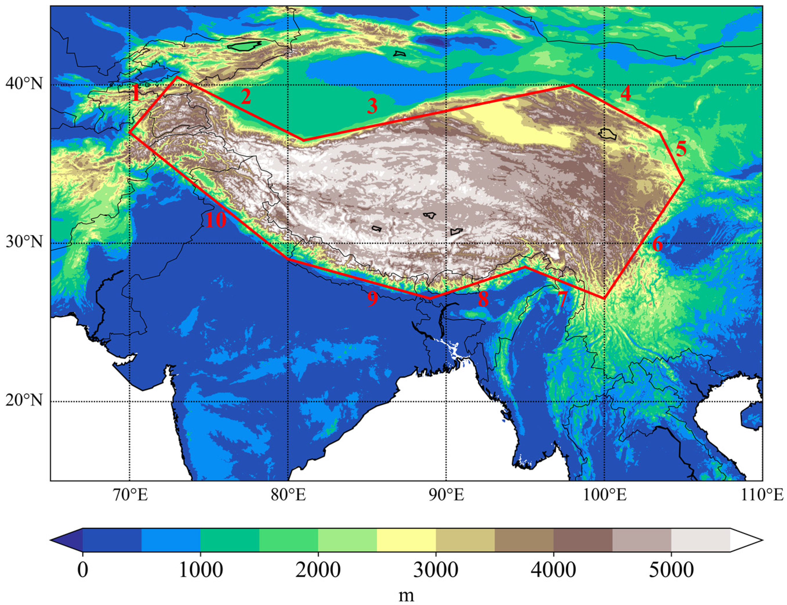
:1. Introduction
2. Materials and Methods
3. Results
3.1. Characteristics of Water Vapor Transport and Precipitation over the TP in Normal ISM Months
3.2. Difference in IVT and Precipitation over the TP between Strong ISM Months and Normal ISM Months
3.3. Difference in IVT and Precipitation between Weak ISM Months and Normal ISM Months
4. Conclusions
Author Contributions
Funding
Institutional Review Board Statement
Informed Consent Statement
Data Availability Statement
Conflicts of Interest
References
- Xu, X.; Lu, C.; Shi, X.; Gao, S. World Water Tower: An Atmospheric Perspective. Geophys. Res. Lett. 2008, 35, L20815. [Google Scholar] [CrossRef]
- Qiu, J. The Third Pole. Nature 2008, 454, 393–396. [Google Scholar] [CrossRef] [PubMed] [Green Version]
- Yao, T.D.; Thompson, L.; Yang, W.; Yu, W.S.; Gao, Y.; Guo, X.J.; Yang, X.X.; Duan, K.Q.; Zhao, H.B.; Xu, B.Q.; et al. Different glacier status with atmospheric circulations in Tibetan Plateau and surroundings. Nat. Clim. Chang. 2012, 2, 663–667. [Google Scholar] [CrossRef]
- Li, Y.; Liao, J.; Guo, H.; Liu, Z.; Shen, G. Patterns and Potential Drivers of Dramatic Changes in Tibetan Lakes, 1972–2010. PLoS ONE 2014, 9, e111890. [Google Scholar] [CrossRef] [PubMed] [Green Version]
- Zhao, L.; Zou, D.; Hu, G.; Du, E.; Pang, Q.; Xiao, Y.; Li, R.; Sheng, Y.; Wu, X.; Sun, Z.; et al. Changing climate and the permafrost environment on the Qinghai–Tibet (Xizang) plateau. Permafr. Periglac. Process. 2020, 31, 396–405. [Google Scholar] [CrossRef]
- Li, S.-L.; Yue, F.-J.; Liu, C.-Q.; Ding, H.; Zhao, Z.-Q.; Li, X. The O and H isotope characteristics of water from major rivers in China. Chin. J. Geochem. 2014, 34, 28–37. [Google Scholar] [CrossRef]
- Bothe, O.; Fraedrich, K.; Zhu, X. Tibetan Plateau summer precipitation: Covariability with circulation indices. Theor. Appl. Climatol. 2011, 108, 293–300. [Google Scholar] [CrossRef]
- Chen, B.; Xu, X.D.; Yang, S.; Zhao, T.L. Climatological Perspectives of Air Transport from Atmospheric Boundary Layer to Tropopause Layer over Asian Monsoon Regions during Boreal Summer Inferred from Lagrangian Approach. Atmos. Chem. Phys. 2012, 12, 5827–5839. [Google Scholar] [CrossRef] [Green Version]
- Gao, Y.; Cuo, L.; Zhang, Y. Changes in Moisture Flux over the Tibetan Plateau during 1979–2011 and Possible Mechanisms. J. Clim. 2014, 27, 1876–1893. [Google Scholar] [CrossRef]
- Hua, L.; Zhong, L.; Ke, Z. Characteristics of the Precipitation Recycling Ratio and Its Relationship with Regional Precipitation in China. Theor. Appl. Climatol. 2017, 127, 513–531. [Google Scholar] [CrossRef]
- Sugimoto, S.; Ueno, K.; Sha, W. Transportation of Water Vapor into the Tibetan Plateau in the Case of a Passing Synoptic-Scale Trough. J. Meteorol. Soc. Jpn. Ser. II 2008, 86, 935–949. [Google Scholar] [CrossRef] [Green Version]
- Sun, C.; Xu, X.; Zhao, T.; Yao, T.; Zhang, D.; Wang, N.; Ma, Y.; Ma, W.; Chen, B.; Zhang, S.; et al. Distinct impacts of vapor transport from the tropical oceans on the regional glacier retreat over the Qinghai-Tibet Plateau. Sci. Total Environ. 2022, 823, 153545. [Google Scholar] [CrossRef] [PubMed]
- Xu, K.; Zhong, L.; Ma, Y.; Zou, M.; Huang, Z. A Study on the Water Vapor Transport Trend and Water Vapor Source of the Tibetan Plateau. Theor. Appl. Climatol. 2020, 140, 1031–1042. [Google Scholar] [CrossRef]
- Yu, J.; Li, Q.; Ding, Y.; Zhang, J.; Wu, Q.; Shen, X. Long-Term Trend of Water Vapor over the Tibetan Plateau in Boreal Summer under Global Warming. Sci. China Earth Sci. 2022, 65, 662–674. [Google Scholar] [CrossRef]
- Zhou, C.; Zhao, P.; Chen, J. The Interdecadal Change of Summer Water Vapor over the Tibetan Plateau and Associated Mechanisms. J. Clim. 2019, 32, 4103–4119. [Google Scholar] [CrossRef]
- Wang, Z.; Duan, A.; Yang, S.; Ullah, K. Atmospheric moisture budget and its regulation on the variability of summer precipitation over the Tibetan Plateau. J. Geophys. Res. Atmos. 2017, 122, 614–630. [Google Scholar] [CrossRef]
- Li, Y.; Su, F.; Chen, D.; Tang, Q. Atmospheric Water Transport to the Endorheic Tibetan Plateau and Its Effect on the Hydrological Status in the Region. J. Geophys. Res. Atmos. 2019, 124, 12864–12881. [Google Scholar] [CrossRef]
- Vaid, B.H.; Kripalani, R.H. Strikingly Contrasting Indian Monsoon Progressions during 2013 and 2014: Role of Western Tibetan Plateau and the South China Sea. Theor. Appl. Climatol. 2021, 144, 1131–1140. [Google Scholar] [CrossRef]
- An, Z.; Colman, S.M.; Zhou, W.; Li, X.; Brown, E.T.; Jull, A.J.T.; Cai, Y.; Huang, Y.; Lu, X.; Chang, H.; et al. Interplay between the Westerlies and Asian monsoon recorded in Lake Qinghai sediments since 32 ka. Sci. Rep. 2012, 2, 619. [Google Scholar] [CrossRef] [Green Version]
- Liu, W.; Wang, L.; Chen, D.; Tu, K.; Ruan, C.; Hu, Z. Large-Scale Circulation Classification and Its Links to Observed Precipitation in the Eastern and Central Tibetan Plateau. Clim. Dyn. 2016, 46, 3481–3497. [Google Scholar] [CrossRef]
- Webster, P.J.; Magaña, V.O.; Palmer, T.; Shukla, J.; Tomas, R.A.; Yanai, M.; Yasunari, T. Monsoons: Processes, predictability, and the prospects for prediction. J. Geophys. Res. Oceans 1998, 103, 14451–14510. [Google Scholar] [CrossRef]
- Yao, T.; Masson-Delmotte, V.; Gao, J.; Yu, W.; Yang, X.; Risi, C.; Sturm, C.; Werner, M.; Zhao, H.; He, Y.; et al. A review of climatic controls on δ18O in precipitation over the Tibetan Plateau: Observations and simulations. Rev. Geophys. 2013, 51, 525–548. [Google Scholar] [CrossRef]
- Feng, L.; Zhou, T. Water vapor transport for summer precipitation over the Tibetan Plateau: Multidata set analysis. J. Geophys. Res. Atmos. 2012, 117, D20114. [Google Scholar] [CrossRef] [Green Version]
- Simmonds, I.; Bi, D.; Hope, P. Atmospheric Water Vapor Flux and Its Association with Rainfall over China in Summer. J. Clim. 1999, 12, 1353–1367. [Google Scholar] [CrossRef]
- Zhu, L.; Lü, X.; Wang, J.; Peng, P.; Kasper, T.; Daut, G.; Haberzettl, T.; Frenzel, P.; Li, Q.; Yang, R.; et al. Climate change on the Tibetan Plateau in response to shifting atmospheric circulation since the LGM. Sci. Rep. 2015, 5, 13318. [Google Scholar] [CrossRef] [PubMed] [Green Version]
- Lin, H.; You, Q.; Zhang, Y.; Jiao, Y.; Fraedrich, K. Impact of Large-Scale Circulation on the Water Vapour Balance of the Tibetan Plateau in Summer. Int. J. Climatol. 2016, 36, 4213–4221. [Google Scholar] [CrossRef] [Green Version]
- Lu, C.; Yu, G.; Xie, G. Tibetan Plateau Serves as a Water Tower. Int. Geosci. Remote Sens. Symp. 2005, 5, 3120–3123. [Google Scholar] [CrossRef]
- Xu, X.; Lu, C.; Shi, X.; Ding, Y. Large-Scale Topography of China: A Factor for the Seasonal Progression of the Meiyu Rainband? J. Geophys. Res. 2010, 115, D02110. [Google Scholar] [CrossRef]
- Wang, Z.; Duan, A.; Wu, G.; Yang, S. Mechanism for Occurrence of Precipitation over the Southern Slope of the Tibetan Plateau without Local Surface Heating. Int. J. Climatol. 2016, 36, 4164–4171. [Google Scholar] [CrossRef] [Green Version]
- Wu, G.; Liu, Y.; Zhang, Q.; Duan, A.; Wang, T.; Wan, R.; Liu, X.; Li, W.; Wang, Z.; Liang, X. The Influence of Mechanical and Thermal Forcing by the Tibetan Plateau on Asian Climate. J. Hydrometeorol. 2007, 8, 770–789. [Google Scholar] [CrossRef]
- Xu, X.; Zhao, T.; Lu, C.; Guo, Y.; Chen, B.; Liu, R.; Li, Y.; Shi, X. An Important Mechanism Sustaining the Atmospheric “Water Tower” over the Tibetan Plateau. Atmos. Chem. Phys. 2014, 14, 11287–11295. [Google Scholar] [CrossRef] [Green Version]
- Xu, X.; Miao, Q.; Wang, J.; Zhang, X. The Water Vapor Transport Model at the Regional Boundary during the Meiyu Period. Adv. Atmos. Sci. 2003, 20, 333–342. [Google Scholar] [CrossRef]
- Dong, W.; Lin, Y.; Wright, J.S.; Ming, Y.; Xie, Y.; Wang, B.; Luo, Y.; Huang, W.; Huang, J.; Wang, L.; et al. Summer rainfall over the southwestern Tibetan Plateau controlled by deep convection over the Indian subcontinent. Nat. Commun. 2016, 7, 10925. [Google Scholar] [CrossRef] [PubMed] [Green Version]
- Zhang, C.; Tang, Q.; Chen, D.; Van Der Ent, R.J.; Liu, X.; Li, W.; Haile, G.G. Moisture Source Changes Contributed to Different Precipitation Changes over the Northern and Southern Tibetan Plateau. J. Hydrometeorol. 2019, 20, 217–229. [Google Scholar] [CrossRef]
- Kukulies, J.; Chen, D.; Wang, M. Temporal and Spatial Variations of Convection, Clouds and Precipitation over the Tibetan Plateau from Recent Satellite Observations. Part II: Precipitation Climatology Derived from Global Precipitation Measurement Mission. Int. J. Climatol. 2020, 40, 4858–4875. [Google Scholar] [CrossRef]
- Hu, L.; Yang, S.; Li, Y.; Gao, S. Diurnal Variability of Precipitation Depth over the Tibetan Plateau and Its Surrounding Regions. Adv. Atmos. Sci. 2010, 27, 115–122. [Google Scholar] [CrossRef]
- Xu, W.; Zipser, E.J. Diurnal Variations of Precipitation, Deep Convection, and Lightning over and East of the Eastern Tibetan Plateau. J. Clim. 2011, 24, 448–465. [Google Scholar] [CrossRef]
- Xinghua, B.; Fuqing, Z.; Sun, J. Diurnal Variations of Warm-Season Precipitation East of the Tibetan Plateau over China Xinghua. Mon. Weather Rev. 2011, 139, 2790–2810. [Google Scholar]
- Chen, J.; Wu, X.; Yin, Y.; Lu, C. Large-Scale Circulation Environment and Microphysical Characteristics of the Cloud Systems Over the Tibetan Plateau in Boreal Summer. Adv. Earth Sp. Sci. 2020, 7, e2020EA001154. [Google Scholar] [CrossRef] [Green Version]
- Chen, J.; Wu, X.; Lu, C.; Yin, Y.; Al, C.E.T. Seasonal and Diurnal Variations of Cloud Systems over the Eastern Tibetan Plateau and East China: A Cloud-Resolving Model Study. Adv. Atmos. Sci. 2022, 39, 1034–1049. [Google Scholar] [CrossRef]
- Hoffmann, L.; Günther, G.; Li, D.; Stein, O.; Wu, X.; Griessbach, S.; Heng, Y.; Konopka, P.; Müller, R.; Vogel, B.; et al. From ERA-Interim to ERA5: The considerable impact of ECMWF’s next-generation reanalysis on Lagrangian transport simulations. Atmos. Chem. Phys. 2019, 19, 3097–3124. [Google Scholar] [CrossRef]
- Laurila, T.K.; Sinclair, V.A.; Gregow, H. Climatology, variability, and trends in near-surface wind speeds over the North Atlantic and Europe during 1979–2018 based on ERA5. Int. J. Climatol. 2021, 41, 2253–2278. [Google Scholar] [CrossRef]
- Jiang, Y.; Yang, K.; Shao, C.; Zhou, X.; Zhao, L.; Chen, Y.; Wu, H. A Downscaling Approach for Constructing High-Resolution Precipitation Dataset over the Tibetan Plateau from ERA5 Reanalysis. Atmos. Res. 2021, 256, 105574. [Google Scholar] [CrossRef]
- Slättberg, N.; Lai, H.; Chen, X.; Ma, Y.; Chen, D. Spatial and Temporal Patterns of Planetary Boundary Layer Height during 1979–2018 over the Tibetan Plateau Using ERA5. Int. J. Climatol. 2022, 42, 3360–3377. [Google Scholar] [CrossRef]
- Zhao, Y.; Zhou, T. Asian Water Tower Evinced in Total Column Water Vapor: A Comparison among Multiple Satellite and Reanalysis Data Sets. Clim. Dyn. 2020, 54, 231–245. [Google Scholar] [CrossRef] [Green Version]
- Hersbach, H.; Bell, B.; Berrisford, P.; Hirahara, S.; Horanyi, A.; Muñoz-Sabater, J.; Nicolas, J.; Peubey, C.; Radu, R.; Schepers, D.; et al. The ERA5 global reanalysis. Q. J. R. Meteorol. Soc. 2020, 146, 1999–2049. [Google Scholar] [CrossRef]
- Shen, Y.; Zhao, P.; Pan, Y.; Yu, J. A high spatiotemporal gauge-satellite merged precipitation analysis over China. J. Geophys. Res. Atmos. 2014, 119, 3063–3075. [Google Scholar] [CrossRef]
- Pan, Y.; Shen, Y.; Yu, J.J.; Zhao, P. Analysis of the Combined Gauge-Satellite Hourly Precipitation over China Based on the OI Technique. Acta Meteor. Sin. 2012, 70, 1381–1389. [Google Scholar]
- Liu, Y.; Chen, H.; Zhang, G.; Sun, J.; Wang, H. The advanced South Asian monsoon onset accelerates lake expansion over the Tibetan Plateau. Sci. Bull. 2019, 64, 1486–1489. [Google Scholar] [CrossRef] [Green Version]
- Wang, B.; Fan, Z. Choice of South Asian Summer Monsoon Indices. Bull. Am. Meteorol. Soc. 1999, 80, 629–638. [Google Scholar] [CrossRef]
- Wang, B.; Wu, R.; Lau, K.M. Interannual Variability of the Asian Summer Monsoon: Contrasts between the Indian and the Western North Pacific-East Asian Monsoons. J. Clim. 2001, 14, 4073–4090. [Google Scholar] [CrossRef]
- Sousa, P.M.; Ramos, A.M.; Raible, C.C.; Messmer, M.; Tomé, R.; Pinto, J.G.; Trigo, R.M. North Atlantic Integrated Water Vapor Transport—From 850 to 2100 CE: Impacts on Western European Rainfall. J. Clim. 2020, 33, 263–279. [Google Scholar] [CrossRef]
- Chen, B.; Xu, X.-D.; Yang, S.; Zhang, W. On the origin and destination of atmospheric moisture and air mass over the Tibetan Plateau. Theor. Appl. Clim. 2012, 110, 423–435. [Google Scholar] [CrossRef]
- Sun, L.; Yang, Y.; Fu, Y.; Zhang, X.; Zhong, L.; Zhao, C.; Ma, M. Summertime Atmospheric Water Vapor Transport between Tibetan Plateau and Its Surrounding Regions during 1990–2019: Boundary Discrepancy and Interannual Variation. Atmos. Res. 2022, 275, 106237. [Google Scholar] [CrossRef]
- Xu, X.; Tian, H.; Qie, K.; He, X.; Zhang, R.; Tu, H. A Study on the Trend of the Upper Tropospheric Water Vapor over the Tibetan Plateau in Summer. Asia-Pac. J. Atmos. Sci. 2021, 57, 277–288. [Google Scholar] [CrossRef]
- Zhang, P.; Liu, Y.; He, B. Impact of East Asian Summer Monsoon Heating on the Interannual Variation of the South Asian High. J. Clim. 2016, 29, 159–173. [Google Scholar] [CrossRef]
- Li, J.; Jin, L.; Li, J.; Zheng, Z.; Yan, Z. Variation in the Positioning of the Asian Summer Monsoon Boundary in the Tibetan Plateau and Potential Drivers. Adv. Meteorol. 2022, 2022, 7206137. [Google Scholar] [CrossRef]
- Lin, C.; Chen, D.; Yang, K.; Ou, T. Impact of Model Resolution on Simulating the Water Vapor Transport through the Central Himalayas: Implication for Models’ Wet Bias over the Tibetan Plateau. Clim. Dyn. 2018, 51, 3195–3207. [Google Scholar] [CrossRef] [Green Version]
- Sun, J.; Yang, K.; Guo, W.; Wang, Y.; He, J.; Lu, H. Why Has the Inner Tibetan Plateau Become Wetter since the Mid-1990s? J. Clim. 2020, 33, 8507–8522. [Google Scholar] [CrossRef]
- Barros, A.P.; Joshi, M.; Putkonen, J.; Burbank, D.W. A study of the 1999 monsoon rainfall in a mountainous region in central Nepal using TRMM products and rain gauge observations. Geophys. Res. Lett. 2000, 27, 3683–3686. [Google Scholar] [CrossRef]
- Ohasawa, T.; Ueda, H.; Hayashi, T.; Watanabe, A. Diurnal Variations of Convec- Tive Activity and Rainfall in Tropical Asia. J. Meteorol. Soc. Jpn. 2001, 79, 333–352. [Google Scholar] [CrossRef] [Green Version]
- Barros, A.P.; Lang, T.J. Monitoring the Monsoon in the Himalayas: Observations in Central Nepal, June 2001. Mon. Weather Rev. 2003, 131, 1408–1427. [Google Scholar] [CrossRef]
- Dirmeyer, P.A.; Brubaker, K.L. Characterization of the Global Hydrologic Cycle from a Back-Trajectory Analysis of Atmospheric Water Vapor. J. Hydrometeorol. 2007, 8, 20–37. [Google Scholar] [CrossRef]
- Zhang, C.; Tang, Q.; Chen, D. Recent Changes in the Moisture Source of Precipitation over the Tibetan Plateau. J. Clim. 2017, 30, 1807–1819. [Google Scholar] [CrossRef]
- Yuan, G.; Yao, X. Impact of Dynamic and Thermal Forcing on the Intensity Evolution of the Vortices over the Tibetan Plateau in Boreal Summer. J. Trop. Meteorol. 2020, 26, 239–252. [Google Scholar] [CrossRef]
- Li, L.; Zhang, R.; Wen, M.; Duan, J.; Qi, Y. Characteristics of the Tibetan Plateau Vortices and the Related Large-Scale Circulations Causing Different Precipitation Intensity. Theor. Appl. Climatol. 2019, 138, 849–860. [Google Scholar] [CrossRef]


| Strong ISM Months | Weak ISM Months |
|---|---|
| 2000.06 | 2002.07 |
| 2001.06 | 2009.06 |
| 2002.06 | 2009.08 |
| 2003.07 | 2012.06 |
| 2004.06 | 2014.06 |
| 2005.07 | 2014.08 |
| 2005.09 | 2015.07 |
| 2006.09 | 2015.08 |
| 2007.06 | 2015.09 |
| 2010.09 | 2018.09 |
| 2013.06 | 2019.07 |
Disclaimer/Publisher’s Note: The statements, opinions and data contained in all publications are solely those of the individual author(s) and contributor(s) and not of MDPI and/or the editor(s). MDPI and/or the editor(s) disclaim responsibility for any injury to people or property resulting from any ideas, methods, instructions or products referred to in the content. |
© 2022 by the authors. Licensee MDPI, Basel, Switzerland. This article is an open access article distributed under the terms and conditions of the Creative Commons Attribution (CC BY) license (https://creativecommons.org/licenses/by/4.0/).
Share and Cite
Liu, T.; Chen, J.; Yang, K.; Deng, L.; Guo, Z. Impacts of the Indian Summer Monsoon on the Southern Boundary Water Vapor Transport and Precipitation over the Tibetan Plateau. Atmosphere 2023, 14, 20. https://doi.org/10.3390/atmos14010020
Liu T, Chen J, Yang K, Deng L, Guo Z. Impacts of the Indian Summer Monsoon on the Southern Boundary Water Vapor Transport and Precipitation over the Tibetan Plateau. Atmosphere. 2023; 14(1):20. https://doi.org/10.3390/atmos14010020
Chicago/Turabian StyleLiu, Tianyu, Jinghua Chen, Kai Yang, Liping Deng, and Zhiyi Guo. 2023. "Impacts of the Indian Summer Monsoon on the Southern Boundary Water Vapor Transport and Precipitation over the Tibetan Plateau" Atmosphere 14, no. 1: 20. https://doi.org/10.3390/atmos14010020