Abstract
This study utilizes the ECMWF ERA5 climate reanalysis database and data from the Southern China Transmission Lines Icing Observation System and applies the T-mode principal component analysis, an objective synoptic pattern classification method, to investigate synoptic characteristics associated with transmission line icing events in southern China between 2014 and 2021. The findings reveal that Southern China’s winter synoptic conditions can be categorized into four patterns, with the predominant pattern featuring a centrally located 850 hPa high-pressure system in Inner Mongolia’s western region. This pattern facilitates the convergence of northwesterly cold air from the north and southwesterly moisture from the south over southern China, resulting in balanced conditions conducive to transmission line icing. Furthermore, during a specific icing event in Zhaoqing City, Guangdong Province, in February 2022, the atmospheric stratification exhibited a distinctive “cold–warm–cold” structure with a pronounced inversion layer, characteristic of freezing and rainy weather conditions that create the requisite environment for transmission line icing. Within the dominant icing synoptic pattern, a northwesterly airflow transports cold air from central Siberia to southern China, accompanied by two primary low-level water vapor transport pathways: one originating as a southwest low-level jet carrying moisture from the Bay of Bengal to the Chinese mainland, and the other stemming from the South China Sea. These findings provide valuable insights into the synoptic conditions contributing to transmission line icing events in the region.
1. Introduction
In the context of global warming, the frequency and intensity of meteorological disasters caused by extreme weather and climate events are increasing [1]. Particularly, China has experienced 16 warm winters since 1985, and has been characterized by cold spells since 2004, with a marked increase in extreme cold winter events, especially since 2008. These cold events include severe freezing rain and snow related disasters in early 2008, as well as low temperature and frequent local extreme cold events in winter in 2009, 2010, 2012, and 2013. Additionally, an extreme cold wave, known as the “overlord” cold wave, occurred in early 2016 [2,3]. In recent years, southern China has experienced frequent severe freezing rain and snow disasters during the winter period. These cold events are characterized by their wide area of influence and long duration. As a result, they have had a significant impact on transportation, communication facilities, and agricultural production. The consequences include inconvenience to people’s daily lives and travel, as well as substantial economic losses for China [1].
Icing events on power transmission lines disrupt the regular operation of the power grid. In severe instances, they can result in accidents such as insulator flashovers, wire breakages caused by power line vibrations, tower tilting, and even collapses. These events lead to substantial damage to the power system [4]. In 2008, widespread freezing rain and snow disasters occurred in southern China, resulting in a direct economic loss of up to 10.45 billion yuan. The post-disaster reconstruction and improvement of the power grid required an investment of 39 billion yuan. In the event of ambient temperatures dropping below 0 °C, tiny droplets of supercooled water or raindrops in the atmosphere come into contact with transmission lines and freeze, creating an ice layer. This ice layer has a detrimental impact on the transmission network’s regular functioning and can lead to accidents such as insulator flashover, transmission line breakage, tower tilting, and collapse. These accidents result in significant losses for the power system [5]. It is evident that severe freezing rain and snow weather pose significant hazards. Consequently, it is crucial to investigate the scientific factors behind the excessive icing of transmission lines in southern China during the winter period. According to the weather phenomena and physical processes involved in the accumulation of ice on transmission lines, this phenomenon can be categorized into two groups [6]. One type of ice accumulation is caused by precipitation, including freezing rain, wet snow, and dry snow. The formation conditions for different types of precipitation vary, especially in the transition zone, where two or several different types may occur simultaneously [7]. The second type of ice accumulation occurs in clouds. This refers to the accumulation of translucent, glass-like ice that appears dense and hairy. It is formed when cloud droplets freeze upon contact with the surface of an object while in a supercooled state. This is called glaze. There is another in-cloud icing type which is referred to as rime [6,8]. Among these, freezing rain is the predominant factor behind icing events on power transmission lines. Freezing rain descends as a liquid, swiftly freezing upon contact with ground-level objects. As weather conditions persist, it solidifies into heavy ice layers, frequently culminating in severe incidents. This study focuses on the power transmission line icing events caused by freezing rain [9].
The current research on freezing rain can be categorized into four main areas. The first area focuses on studying the physical mechanism of freezing rain formation [10,11]. The second area involves studying the atmospheric circulation patterns conditions in which freezing rain occurs [8,12,13,14,15,16,17,18,19]. The third area involves simulation studies of freezing rain [20,21,22]. Lastly, a few scholars have examined the particle spectrum of freezing rain [23].
In China, several studies have analyzed the causes of freezing rain and snow related disasters in January 2008 [4,24]. These studies found that the prolonged presence of a blocking high-pressure system, coupled with the strong development of a high-pressure ridge in the Ural Mountains, led to the transport of cold air southward by a northerly steering airflow in front of the ridge. Additionally, the southwesterly airflow in front of the trough transported water vapor northward. The stable existence of an inversion layer between 925 and 700 hPa further contributed to the occurrence of freezing rain and snow by creating an intersection between the cold air and warm, humid airflow. Gao et al. examined the ground and atmospheric vertical thermal structure configuration and climate anomalies [1]. They found that the mean surface temperature in January 2008 in the south was 4–6 °C lower than in previous years. Additionally, the atmosphere in the lower and middle troposphere was generally warm, and the strong northerly wind at the surface contributed to the rare freezing rain and snow disaster that occurred that year. Liao et al. analyzed the fractal characteristics of circulation in eight persistent wet-freezing events that occurred since 1980 [25]. The study concluded that these events were primarily associated with the large-scale circulation patterns of single- and double-resistance types. Wu et al. concluded that the tropical intra-seasonal inertial oscillation, characterized by enhanced convection in the central equatorial region of the Indian Ocean and suppressed convection in Indonesia, created favorable conditions for persistent precipitation in the southern region in 2008 [26].
Unlike most prior studies, the present study attempted to investigate the atmospheric circulation patterns and upper-level atmospheric layer junction contributing to the icing events on power transmission lines in southern China. Specifically, we examined the typical icing synoptic pattern and explored the meteorological causes of icing events on power transmission lines in southern China.
2. Data and Methods
2.1. Data
The data sources utilized in this study encompass:
Information gathered from the Ultra-High Voltage Power Transmission Line Icing Observation System, spanning the period between November 2014 and February 2022. This dataset comprises records of power transmission line icing thickness and air temperature, with monitoring intervals of 10 min, 20 min, or 30 min per data point. The observation heights are all 20 m above the surface.
ERA5 hourly data are accessible at 0.25° × 0.25° resolution covering the time frame of November 2014 to February 2022. Here, we use geopotential height, temperature, u-component of wind, v-component of wind, vertical velocity, specific humidity, and relative humidity within the layer extending from 1000 hPa to 400 hPa.
2.2. Methods
The objective synoptic pattern classification method used in this paper, T-mode principal component analysis (T-PCA) is a mathematical technique that allows for the objective classification of synoptic patterns within the lower and middle tropospheric circulation fields. It does so without the need for predefined parameters, relying instead on regional lattice data [27,28]. T-PCA is advantageous in handling large datasets and does not rely on subjective user experience [27]. It has been extensively utilized in various countries for regional circulation classification, downscaling analysis, quantitative studies of climate change, and climate prediction. This method objectively classifies the synoptic patterns using weather data such as geopotential height, sea level pressure, wind direction and speed, and air temperature. The objective classification of the synoptic patterns provides a more comprehensive understanding and analysis of the weather mechanisms driving extreme weather events. In comparison to subjective synoptic pattern classification, objective synoptic pattern classification methods have gained significant traction in studies related to air pollution [29,30,31,32,33,34].
This paper employs the Cost733 synoptic pattern classification package, developed by the EU Cost733 project team (http://www.cost733.org, accessed on 26 September 2023). The utilization of this package aims to conduct an oblique rotational decomposition of the 850 hPa geopotential height field, leading to more precise synoptic pattern classification outcomes. Cost733 encompasses multiple modules designed to streamline the classification, assessment, and juxtaposition of weather patterns. The classification principle of the T-PCA software module is outlined as follows: the original high-dimensional data Z are decomposed into 2 low-dimensional matrices, F and A. Z = F A T with N spatial lattice points per row and M observation times per column, where F is the principal component (PC) and A is the PC loading. The principal components are sorted based on the magnitude of their associated eigenvalues. The first K principal components (where K ≤ M) are chosen if their cumulative contribution rate surpasses a specific threshold, typically around 85%. This process effectively reduces dimensionality while maintaining the essential traits of the original circulation field. The adjustments to the fractal object are minimal, ensuring that the resulting spatio-temporal field remains stable [28,34,35].
We opted for the clustered variance (ECV) as a metric to assess the efficiency of objective weather typing and to establish the number of typological categories. ECV is computed by dividing the within-class sum of squares (WSS) by the total sum of squares (TSS):
The ECV ranges from 0 to 1. WS represents the sum of squares within the synoptic patterns, while TS represents the sum of squares.
where k is the weather pattern number, Cj is pattern j, and the squared Euclidean distance between an element and its center of mass is defined as
where is the time step ( = 1, 2, …, m), is the respective data point, is an estimate of the mean value of weather pattern j, and is an estimate of the total mean value.
Equations (1)–(4) can also be calculated by the Cost733class-1.2_RC_revision89 software. Then, the weather pattern number k can be determined from the ECV incremental values, which are defined as
when ΔECV reaches its maximum value, the final number of typing categories, k, can be determined. This leads to a significant improvement and stabilization in the classification performance, allowing for an objective classification of the synoptic patterns [23,36].
3. Classifications of Synoptic Patterns
Previous studies have indicated that prolonged cold and freezing events are mainly determined by the configuration of anomalies in the tropospheric high-, middle-, and low-level circulation [37,38,39]. In this section, we use the objective synoptic pattern classification method to classify the 850 hPa geopotential height field in southern China. The whole winter classification started from November to February from 2014 to 2021. The classification region spans from 15° N to 45° N and 95° E to 125° E. The central focus of this study lies within southern China, demarcated by the black box in Figure 1. Furthermore, we utilize icing thickness data from the Southern China Transmission Lines Icing Observation System from 2014 to 2021 within this region to identify the dominant synoptic patterns responsible for icing events on power transmission lines in southern China. Subsequently, we analyze the synoptic characteristics of icing events on power transmission lines in southern China, considering aspects of atmospheric circulation patterns, atmospheric stratification, and the pathways of cold air and moisture transport.
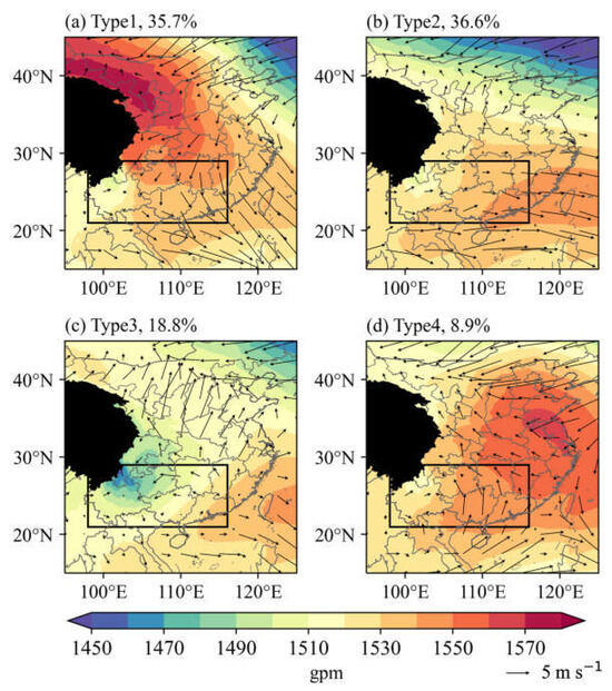
Figure 1.
The 850 hPa geopotential height fields of the four patterns (shading, units: gpm): (a) type 1, (b) type 2, (c) type 3, and (d) type 4. Wind vector fields and frequency of occurrence (left upper number) for four synoptic patterns during winter seasons from 2014 to 2021. Filled colors are geopotential height. Black arrows are wind vectors. The black line frames show the location of southern China. The black area represents the Tibetan Plateau. The patterns with red and blue fonts belong to the main categories of high-pressure patterns and the low-vortex patterns, respectively.
3.1. Synoptic Patterns
In this study, the results show that ΔECV with four types had the highest value, indicating a good performance in the synoptic pattern classification for the study area. Thus, the synoptic patterns over southern China were objectively classified into four types to study their synoptic characteristics related to icing events on transmission lines. Figure 1 shows the results of the four synoptic patterns classified by T-PCA. Table 1 shows the characteristics of the four synoptic patterns classified by T-PCA.

Table 1.
Characteristics of four synoptic patterns.
3.2. Relationships between Synoptic Patterns and Icing Events
To identify the predominant weather patterns responsible for transmission line icing events in southern China, two statistical methods were applied to analyze the occurrences of power line icing events within the study area from 2014 to 2021. Given the confidentiality of specific latitude and longitude information for the towers, this section employed the Ordinary Kriging interpolation method for the icing data. This interpolation method obscured the exact latitude and longitude information while preserving statistical accuracy. The first statistical method calculated the frequency of icing events on power transmission lines in the study area from 2014 to 2021 under four synoptic patterns, as illustrated in Figure 2. Notably, the highest frequency of icing events occurred under the type 1 synoptic pattern. The second statistical method involved calculating the probability of icing events on transmission lines occurring in southern China from 2014 to 2021 when the four different synoptic patterns occurred, as depicted in Figure 3. Among these patterns, the type 1 synoptic pattern exhibited the highest probability of icing events on power transmission lines, reaching as high as 15%. This implies that, when the type 1 synoptic pattern occurs, southern China is most susceptible to ice accumulation on power transmission lines.
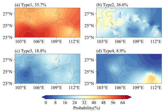
Figure 2.
The frequency of transmission line icing events in southern China from 2014 to 2021 under four patterns: (a) type 1, (b) type 2, (c) type 3, and (d) type 4. Frequency of occurrence for four synoptic patterns during winter seasons from 2014 to 2021 (left upper number).
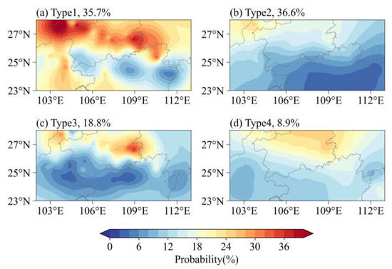
Figure 3.
The probability of transmission line icing events when four patterns occur in southern China from 2014 to 2021: (a) type 1, (b) type 2, (c) type 3, and (d) type 4. Frequency of occurrence for four synoptic patterns during winter seasons from 2014 to 2021 (left upper number).
Both statistical methods consistently underscore the prominence of the type 1 synoptic pattern as the primary factor contributing to transmission line ice accumulation in southern China. This suggests that the type 1 synoptic pattern, as illustrated in Figure 1a, plays a dominant role. Type 1 pattern is characterized by a closed high-pressure system in western Inner Mongolia at the 850 hPa level, with its high-pressure ridge extending southward to encompass a significant portion of southern China. This high-pressure system exerts considerable influence over North China, Central China, and South China.
Consequently, this study designates the type 1 synoptic pattern as the dominant synoptic pattern associated with transmission line icing events in southern China. Subsequent investigations will focus on the type 1 synoptic pattern and analyze the synoptic characteristics behind icing events on power transmission lines in southern China, considering atmospheric stratification, cold air and moisture transport pathways.
3.3. Cold Air and Moisture Transport Paths
To gain a more profound understanding of the cold air and moisture transport pathways responsible for ice accumulation on power transmission lines in southern China, this study conducted a comprehensive synthesis of the vector wind and temperature fields at 700 hPa, 850 hPa, and 925 hPa, all associated with the dominant icing events synoptic pattern. Additionally, the research synthesized the moisture fluxes and temperature fields.
The situation at the 850 hPa altitude is analogous to that at the 700 hPa level. As depicted in Figure 4b, there is a robust northerly airflow transporting cold air from the Central Siberian region through northeastern China. In the northern regions of southern China, prevailing conditions are dominated by cold advection, which covers a broader area compared to the conditions at 700 hPa. Meanwhile, in southern China, there is a warm and humid advection, as indicated in Figure 5b. The convergence of these two air masses in southern China further supports freezing rain and snow related disasters.
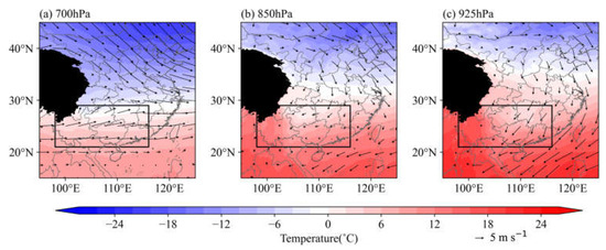
Figure 4.
Cold air paths of type 1 pattern at (a) 700 hPa, (b) 850 hPa, and (c) 925 hPa. Filled colors are temperature fields, vectors are wind fields in m s−1, the black area represents the Tibetan Plateau, and black line frames indicate the study area in this section.
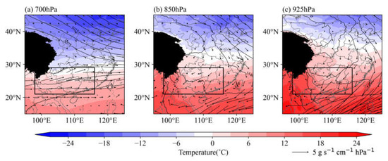
Figure 5.
Water vapor flux transport paths of type1 pattern at (a) 700 hPa, (b) 850 hPa, and (c) 925 hPa. Filled colors are temperature fields, vectors are moisture transport flux in g s−1 cm−1 hPa−1, black area represents the Tibetan Plateau, and black line frames indicate the study area in this section.
At the lower tropospheric level of 925 hPa, northeastern China, central China, and southern China all experience strong northwesterly wind anomalies and cold advection (Figure 4c). Additionally, when considering the atmospheric conditions at 700 hPa, 850 hPa, and 925 hPa, it is evident that the northwesterly wind anomalies guide the southward intrusion of cold air into China, creating the necessary low-temperature conditions conducive to the occurrence of sustained low-temperature rain, snow, and freezing events.
4. Case Study
From 19 to 21 February 2022, a strong cold air mass moved southward and intersected with a warm and moist southwest airflow, resulting in a significant cooling process in southern China. During this period, multiple transmission lines in the western Guangdong province experienced ice accumulation. Observations recorded a maximum ice thickness of 33.92 mm, with the most severe ice-covered area concentrated along the Xindong Line. This ice accumulation had a substantial impact on transmission lines. Therefore, this section will take this icing event as a typical case to systematically study the synoptic characteristics and causes of this icing event on transmission lines.
The atmospheric circulation situation of this icing event will be compared with the type 1 synoptic pattern to validate the conclusions made in the previous section.
4.1. Trend of the Ice Thickness
This section focused its investigation on four transmission towers along the Xindong Line experiencing relatively severe ice accumulation. Due to the confidentiality of grid security information, these towers are referred to as A, B, C, D, E, F, and G for specific identification. Figure 6 shows the time-dependent variations in the average icing thickness and average observed air temperature for the four towers during this icing event. Table 2 provides details on the maximum icing thickness, corresponding time, and observed air temperature for each tower during this icing event. All times used in this study are in Coordinated Universal Time (UTC). Overall, this icing event exhibited two growth phases. Around 12:00 on 19 February, the towers began to accumulate ice, and by 00:00 on 20 February, the temperature had risen, reaching the first peak in ice thickness. Around 12:00 on 20 February, temperatures dropped again, and ice accumulation continued, reaching its second peak around 00:00 on 21 February. Subsequently, manual intervention through increased current in the power grid resulted in the melting of the ice. Among the towers, line C experienced the most severe ice accumulation, with a maximum ice thickness of 33.92 mm and an average growth rate of 0.817 mm/h, with a temperature of −0.4 °C. In contrast, line B had the lightest ice accumulation, with a maximum thickness of 6.5 mm and an average growth rate of 0.1625 mm/h, with a temperature of −0.1 °C.
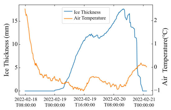
Figure 6.
Trend of observed ice thickness and air temperature from 18 to 21 February 2022. The blue line represents the average ice thickness on four towers. The orange line represents the average observed air temperature on four towers.

Table 2.
The maximum icing thickness of towers during icing event and corresponding time and air temperature.
4.2. Atmospheric Circulation Patterns
Figure 7 depicts the 500 hPa large-scale geopotential height field overlaid with wind vectors at 8 h intervals from 18 to 21 February 2022. At 16:00 on 18 February, there was a small low trough in the western part of Inner Mongolia, while a low-pressure center influenced the northeastern region of China, and the western Pacific subtropical high was displaced to the west. By 08:00 on 19 February, the small trough, which had developed and moved eastward, reached the northeastern region of China, characterized by closely spaced isobars. At 00:00 on 20 February, the southern branch of the trough gradually moved eastward, and the western Pacific subtropical high strengthened, retreating to 110° E. By 08:00 on 20 February, the small trough had intensified into a larger one. As the low-pressure trough influenced it, cold air moved southward rapidly, leading to a significant temperature drop. The strong western Pacific subtropical high transported moisture from the ocean to the southern region. At 16:00 on 20 February, the southern branch of the trough further strengthened and moved eastward. The northwesterly airflow behind the trough in the northeastern region continuously guided cold air southward, but the exceptionally strong Western Pacific Subtropical High weakened the cold air to some extent. By 08:00 on 21 February, the meridional extension of the trough had increased, intensifying its impact on Guangxi Province. The cold vortex gradually moved southward, and the western Pacific subtropical high retreated to 120° N, leading to a gradual reduction in moisture transport to the southern region.
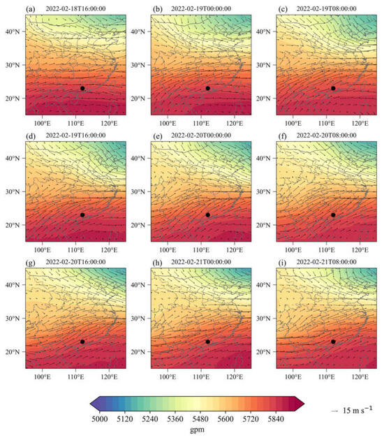
Figure 7.
Large-scale circulation fields at 500 hPa. Filled colors are 500 hPa geopotential height fields in gpm. Vectors are wind fields in m s−1. Scattered markers indicate the locations of the icing event.
Figure 8 presents the 850 hPa geopotential height field overlaid with the temperature field at 8 h intervals from 19 to 21 February 2022. From 19 to 20 February, a closed high-pressure system, known as the Siberian High, developed over western Inner Mongolia. The high-pressure ridge extended southward to the southern regions of China, while a northeastern cold vortex moved eastward towards the sea. The first cold air mass invaded southern China from the north. The western part of Guangdong Province was located near the front, where dry and cold air existed on the northern side of the front and warm and moist airflow on the southern side. These two air masses, with contrasting properties, converged in the upper atmosphere over the western part of Guangdong Province. When the cold air prevailed over the warm air, a rapid cooling occurred, leading to the freezing of supercooled droplets or the deposition of supercooled fog droplets on the power transmission lines, resulting in ice accumulation. Conversely, when the warm air prevailed over the cold air, temperatures increased, causing the ice to melt. From 20 to 21 February, the southern ridge of the Siberian High developed, and the preceding northwesterly airflow guided a new round of cold air to move southward, leading to a continued cooling in southern China. At the same time, the southwestern airflow continuously transported moisture from the Bay of Bengal to southern China. These two forces met in the stratosphere over southern regions of China, causing the formation of icing on power transmission lines.
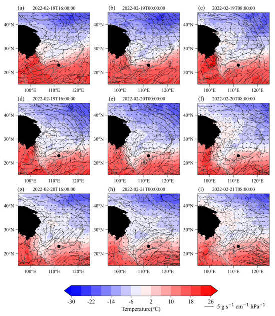
Figure 8.
Large-scale circulation fields at 850 hPa. Filled colors are temperature fields in °C. Contours are 850 hPa geopotential height fields in gpm. Vectors are moisture transport flux in g s−1 cm−1 hPa−1. Scattered markers indicate the locations of the icing event. The black area represents the Tibetan Plateau.
During this icing event, the configuration of the atmospheric circulation at 850 hPa height is very similar to the type 1 synoptic pattern obtained from objective synoptic pattern classification. Both have a closed high-pressure pattern in the western part of Inner Mongolia. The high-pressure ridge extends southward to southern China, with a more extensive range and vigorous intensity, which verifies the conclusion obtained in the previous subsection. Therefore, we identify the type 1 pattern as the dominant synoptic pattern during icing events on transmission lines in southern China.
4.3. Atmospheric Stratification
Figure 9 offers a time series of vertical profiles of temperature and relative humidity during this icing event. The profile positions were selected to correspond to the central location of this icing event of 112.75° E, 24° N [5,25]. During the icing process, a distinct inversion layer is consistently present in the lower troposphere within this region, exhibiting the typical vertical structure of “cold–warm–cold”. This structural pattern is recognized as a key characteristic associated with freezing rain weather [39,40,41]. The inversion layer impedes the vertical movement of air, causing a large amount of water vapor to accumulate below the inversion layer. In conjunction with the cold air layer below 0 °C beneath the inversion layer, freezing rain and snow occur, leading to ice accumulation on power transmission lines. Additionally, the ice-covered area had abundant water vapor in the upper atmosphere, providing favorable conditions for ice accumulation on power transmission lines.
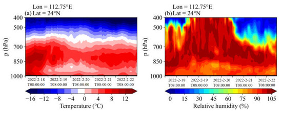
Figure 9.
Time series of vertical profiles of (a) temperature and (b) relative humidity. Filled colors are (a) temperature and (b) relative humidity. Shaded areas represent topographical obstructions.
Figure 10 and Figure 11 present vertical profiles of latitudinal and longitudinal temperatures and relative humidity at the moment of maximum ice thickness during this icing event. The selected profiles are located at the center of the icing event. In the latitudinal profile, in the upper boundary layer of the ice-covered area, there is a strong, warm, and humid airflow coming from the south, lifting northward. Simultaneously, in the near-surface layer, cold air from the north is descending and invading southward. These two airflows are of equal strength and hold each other over the ice-covered region, leading to freezing rain and snow. In the longitudinal profile, within the near-surface layer of the ice-covered area, there is a strong easterly wind that transports moisture from the ocean to this region, providing favorable moisture conditions for ice accumulation on power transmission lines.
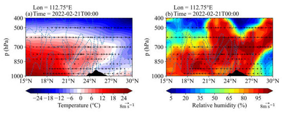
Figure 10.
Vertical profiles of latitudinal (a) temperature and (b) relative humidity at the moment of maximum ice cover thickness. Filled colors are (a) temperature and (b) relative humidity. Blue dotted lines are vertical velocity of air in 10−2 m s −1. Vectors are v-component of wind in m s −1.
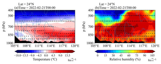
Figure 11.
Vertical profiles of longitudinal (a) temperature and (b) relative humidity at the moment of maximum ice cover thickness. Filled colors are (a) temperature and (b) relative humidity. Blue dotted lines are vertical velocity of air in 10−2 m s−1. Vectors are v−component of wind in m s −1.
5. Discussion
This study delved into the synoptic characteristics of icing events on transmission lines in southern China, examining them from the perspective of atmospheric circulation. Our future work may encompass the following aspects.
In our forthcoming research, we aim to delve deeper into the spatio-temporal distribution characteristics of icing events on transmission lines in southern China from 2014 to 2021. This entails a nuanced analysis of different months and geographical locations to comprehensively comprehend the patterns of icing events. Subsequent investigations will center on exploring the correlation between icing thickness and meteorological factors. A meticulous examination of factors such as temperature, humidity, and wind speed will be conducted to unveil their potential associations with power transmission line icing, providing a more accurate reference for future prediction and prevention efforts. The incorporation of machine learning methods stands out as a pivotal direction in our future research. We envisage leveraging advanced machine learning algorithms, in conjunction with extensive historical data, to establish predictive models that significantly enhance the accuracy of forecasting the transmission line icing thickness. This has the potential to provide a more effective means of warning and managing power system operations. In our subsequent studies, we plan to closely integrate actual meteorological station data for analysis. This collaborative approach will play a pivotal role in validating the accuracy of the models and providing a practical basis for model improvements. By making comparisons with actual observational data, we can more reliably assess the performance of the models.
These prospective endeavors will empower us to gain a more comprehensive understanding of icing events on power transmission lines, offering deeper insights for research in related fields and improving the operation of power systems.
6. Conclusions
This study analyzes the 850 hPa geopotential height fields of the winter from 2014 to 2021 in southern China by using the method of objective synoptic pattern classification. It explores the dominant synoptic pattern of the icing events on the transmission lines in winter in southern China. The 850 hPa circulation fields of this icing event are compared with the results of the objective synoptic pattern classification and the following conclusions are obtained:
- (1)
- Large-scale circulation patterns: the results of the objective synoptic pattern classification reveal that there are four primary winter synoptic patterns in southern China. By comparing these patterns with power transmission line icing thickness data from 2014 to 2021 and the atmospheric circulation pattern during the February 19th to 21st, 2022, icing event, it was determined that the type 1 synoptic pattern is the dominant icing synoptic pattern for southern China. In this pattern, southern China is influenced by a high-pressure system at 850 hPa, centered in western Inner Mongolia, with a substantial southward extension. During this period, a robust northwesterly flow in the 500 hPa level brings cold air to southern China. Furthermore, the westward expansion of the enhanced subtropical high-pressure system in the western Pacific directs warm and humid airflow from the ocean to southwestern China. Under these conditions, the likelihood of power transmission line icing in southern China is heightened.
- (2)
- Temperature and humidity vertical structures: during the initial stages of icing, a strong upward flow of warm and humid air occurs in the upper boundary layer, while cold air descends near the surface, leading to the formation of an inversion layer. The vertical structure over the icing area exhibits a “cold–warm–cold” pattern, characterized by a prominent inversion layer. This vertical arrangement is indicative of freezing rain weather and provides the necessary conditions for the icing events on power transmission lines in southern China.
- (3)
- Cold air and moisture transport pathways: under the dominant icing synoptic pattern, the intensification of the Northeast China Vortex results in a potent northwesterly airflow that carries cold air from Central Siberia through northeastern China. Simultaneously, two primary lower-level moisture transport routes are active. One involves a southwest low-level jet transporting moisture from the Bay of Bengal toward mainland China, while the other originates from the South China Sea. These moisture transport pathways contribute to abundant moisture conditions, which are crucial for the icing events on power transmission lines in southern China.
Author Contributions
Conceptualization, H.S., J.K. and H.C.; methodology, H.S., S.Z. and Z.G.; software, H.S. and B.W. All authors have read and agreed to the published version of the manuscript.
Funding
This study is supported by the Second Tibetan Plateau Scientific Expedition and Research Program (2019QZKK0102) and by the National Key Research and Development Program of the Ministry of Science and Technology of China (2023YFC3706300).
Institutional Review Board Statement
Not applicable.
Informed Consent Statement
Not applicable.
Data Availability Statement
The observed icing thickness data and temperature data in this paper are available on request from the corresponding authors. ERA5 hourly reanalysis data in this paper can be found at https://cds.climate.copernicus.eu/cdsapp#!/dataset/reanalysis-era5-single-levels?tab=form (accessed on 26 January 2023).
Conflicts of Interest
The authors declare no conflict of interest.
References
- Gao, Y.; Wu, T.W.; Chen, B.D. Anomalous thermodynamic conditions for freezing rain in southern China in January 2008 and their cause. Plateau Meteorol. 2011, 30, 1526–1533. (In Chinese). Available online: https://kns.cnki.net/kcms2/article/abstract?v=3uoqIhG8C44YLTlOAiTRKgchrJ08w1e7tvjWANqNvp-l9ua3oAeX_jfDo-igshPlygJQaS1ciCzZTcs-08yaT8wIbhIRd1L3&uniplatform=NZKPT (accessed on 18 March 2023).
- Li, Y.; Wang, J.H.; Wang, S.G. The integrated circulation anomalies of polar vortex, blocking and the Siberian high over the extreme low-temperature events. J. Lanzhou Univ. Nat. Sci. 2019, 55, 51–63. [Google Scholar] [CrossRef]
- Liao, Z.; Zhai, P.; Chen, Y.; Lu, H. Differing mechanisms for the 2008 and 2016 wintertime cold events in southern China. Int. J. Climatol. 2020, 40, 4944–4955. [Google Scholar] [CrossRef]
- Wang, Q.; Zhang, H.R.; Zong, L.; Su, H.H.; Yang, Y.J.; Gao, Z.Q. Synoptic cause of a continuous conductor icing event on ultra-high-voltage transmission lines in northern Guangxi in 2015. J. Trop. Meteorol. 2021, 37, 579–589. (In Chinese) [Google Scholar] [CrossRef]
- Tao, Y.; Wu, X.L.; Duan, X.; He, H.; Wang, M. Meteoroloqical conditions of wire ice coating in northeastern Yunnan in 2008. J. Catastrophol. 2009, 24, 82–86. (In Chinese) [Google Scholar]
- Farzaneh, M.; Volat, C.; André, L. Atmospheric Icing of Power Networks; Springer: Dordrecht, The Netherlands, 2008; pp. 229–268. [Google Scholar] [CrossRef]
- Stewart, R.E. Precipitation types in the transition region of winter storms. Bull. Am. Meteorol. Soc. 1992, 73, 287–296. [Google Scholar] [CrossRef]
- Forbes, G.S.; Thomson, D.W.; Anthes, R.A. Synoptic and mesoscale aspects of an appalachian ice storm associated with cold-air damming. Mon. Weather. Rev. 1987, 115, 564–591. [Google Scholar] [CrossRef]
- Dore, M. Forecasting the conditional probabilities of natural disasters in Canada as a guide for disaster preparedness. Nat. Hazards 2003, 28, 249–269. [Google Scholar] [CrossRef]
- Bennett, W.J. The sleet storm in northern New York, March 25–27. Mon. Weather. Rev. 1913, 41, 372–380. [Google Scholar] [CrossRef]
- Meisinger, C.L. The precipitation of sleet and the formation of glaze in the eastern United States, January 20 to 25, 1920, with remarks on forecasting. Mon. Weather. Rev. 1920, 48, 73–80. [Google Scholar] [CrossRef]
- Cooper, W.; Marwitz, J. Winter storms over the San Juan Mountains. Part III: Seeding Potential. J. Appl. Meteorol. 1980, 19, 942–949. [Google Scholar] [CrossRef]
- Dunn, L. Cold air damming by the front range of the Colorado Rockies and its relationship to locally heavy snows. Weather. Forecast. 1987, 2, 177–189. [Google Scholar] [CrossRef]
- Dunn, L.B. Evidence of ascent in a sloped barrier jet and an associated heavy-snow band. Mon. Weather. Rev. 1992, 120, 914–924. [Google Scholar] [CrossRef]
- Rauber, R.M.; Ramamurthy, M.K.; Tokay, A. Synoptic and mesoscale structure of a severe freezing rain event: The St. Valentine’s Day Ice Storm. Weather. Forecast. 1994, 9, 183–208. [Google Scholar] [CrossRef]
- Szeto, K.K.; Tremblay, A.; Guan, H.; Hudak, D.R.; Stewart, R.E.; Cao, Z. The mesoscale dynamics of freezing rain storms over eastern Canada. J. Atmos. Sci. 1999, 56, 1261–1281. [Google Scholar] [CrossRef]
- Jr, J.V.C.; Bernstein, B.C.; Robbins, C.C.; Strapp, J.W. An analysis of freezing rain, freezing drizzle, and ice pellets across the United States and Canada: 1976–90. Weather. Forecast. 2004, 19, 377–390. [Google Scholar] [CrossRef]
- Cortinas, J. A Climatology of freezing rain in the Great Lakes region of north America. Mon. Weather. Rev. 2000, 128, 3574–3588. [Google Scholar] [CrossRef]
- Rauber, R.M.; Olthoff, L.S.; Ramamurthy, M.K.; Kunkel, K.E. Further investigation of a physically based, nondimensional parameter for discriminating between locations of freezing rain and ice pellets. Weather. Forecast. 2001, 16, 185–191. [Google Scholar] [CrossRef]
- Chai, H.; Zhang, H.R.; Wang, Q.; Su, H.H.; Yang, Y.J.; Gao, Z.Q. Spatial and temporal distribution characteristics, numerical simulation and weather science causes of a large scale icing process on UHV transmission lines in Yunnan-Guizhou plateau. Plateau Meteorol. 2023, 42, 359–373. (In Chinese). Available online: https://kns.cnki.net/kcms2/article/abstract?v=3uoqIhG8C44YLTlOAiTRKu87-SJxoEJu6LL9TJzd50lhMXpdy_t7j0BJXSYBFriqSr_4IROeXRn3DQbTce6Wpa3atIwlfYsx&uniplatform=NZKPT (accessed on 18 February 2023).
- Tremblay, A.; Glazer, A. An improved modeling scheme for freezing precipitation forecasts. Mon. Weather. Rev. 2000, 128, 1289–1308. [Google Scholar] [CrossRef]
- Rasmussen, R.M.; Geresdi, I.; Thompson, G.; Manning, K.; Karplus, E. Freezing drizzle formation in stably stratified layer clouds: The role of radiative cooling of cloud droplets, cloud condensation nuclei, and ice initiation. J. Atmos. Sci. 2002, 59, 837–860. [Google Scholar] [CrossRef]
- Huffman, G.J.; Norman, G.A. The supercooled warm rain process and the specification of freezing precipitation. Mon. Weather. Rev. 1988, 116, 2172–2182. [Google Scholar] [CrossRef]
- Zou, H.B.; Liu, X.M.; Wu, J.J.; Wu, S.S.; Yuan, Z.J.; Wang, S.H. A quantitative study for abnormal snowstorms in southern china in early 2008. J. Trop. Meteorol. 2011, 27, 345–356. (In Chinese). Available online: https://kns.cnki.net/kcms2/article/abstract?v=3uoqIhG8C44YLTlOAiTRKgchrJ08w1e7tvjWANqNvp9WRnLM6q0DXPez8O_c3JN29ufEyY9GVBJXpU5IDLrmS056dfsDrNkL&uniplatform=NZKPT (accessed on 1 February 2023).
- Liao, Z.; Zhai, P.; Chen, Y.; Lu, H. Atmospheric circulation patterns associated with persistent wet-freezing events over southern China. Int. J. Climatol. 2017, 38, 3976–3990. [Google Scholar] [CrossRef]
- Wu, J.J.; Yuan, Z.J.; Duan, L.; Qian, Y.K.; Qi, J.D.; Liang, C.X. Effects of preceding autumn snow cover and sst on large-scale circulations of the freezing rain and snow storm over southern China in january 2008. J. Trop. Meteorol. 2014, 30, 345–352. (In Chinese). Available online: https://kns.cnki.net/kcms2/article/abstract?v=3uoqIhG8C44YLTlOAiTRKgchrJ08w1e7M8Tu7YZds88unPSG0stqnmtGkjPRQbrZZeWlNj-wXWl3CSsf6k4LD2IHktvRz1KX&uniplatform=NZKPT (accessed on 8 February 2023).
- Chang, L.; Xu, J.; Qu, Y.; Mao, Z.; Zhou, G. Study on objective synoptic classification on ozone pollution in Shanghai. Acta Sci. Circumstantiae 2019, 39, 169–179. (In Chinese) [Google Scholar] [CrossRef]
- Huth, R.; Beck, C.; Philipp, A.; Demuzere, M.; Ustrnul, Z.; Cahynová, M.; Kysel, J.; Tveito, O.E. Classifications of atmospheric circulation patterns. Ann. N. Y. Acad. Sci. 2008, 1146, 105–152. [Google Scholar] [CrossRef]
- Miao, Y.; Liu, S.; Huang, S. Synoptic pattern and planetary boundary layer structure associated with aerosol pollution during winter in Beijing, China. Sci. Total Environ. 2019, 682, 464–474. [Google Scholar] [CrossRef]
- Miao, Y.; Guo, J.; Liu, S.; Liu, H.; Li, Z.; Zhang, W.; Zhai, P. Classification of summertime synoptic patterns in Beijing and their associations with boundary layer structure affecting aerosol pollution. Atmos. Chem. Phys. 2017, 17, 3097–3110. [Google Scholar] [CrossRef]
- Ning, G.; Wang, S.; Yim, S.; Li, J.; Hu, Y.; Shang, Z.; Wang, J.; Wang, J. Impact of low-pressure systems on winter heavy air pollution in the northwest Sichuan Basin, China. Atmos. Chem. Phys. 2018, 18, 13601–13615. [Google Scholar] [CrossRef]
- Philipp, A.; Bartholy, J.; Beck, C.; Erpicum, M.; Esteban, P.; Fettweis, X.; Huth, R.; James, P.; Jourdain, S.; Kreienkamp, F. Cost733cat—A database of weather and circulation type classifications. Phys. Chem. Earth 2010, 35, 360–373. [Google Scholar] [CrossRef]
- Stefan, S.; Necula, C.; Georgescu, F. Analysis of long-range transport of particulate matters in connection with air circulation over central and eastern part of Europe. Phys. Chem. Earth 2010, 35, 523–529. [Google Scholar] [CrossRef]
- Xu, J.M.; Chang, L.Y.; Ma, J.H.; Mao, Z.C.; Chen, L.; Cao, Y. Objective synoptic weather classification on PM2.5 pollution during autumn and winter seasons in Shanghai. Acta Sci. Circumstantiae 2016, 36, 4303–4314. [Google Scholar] [CrossRef]
- Huth, R. An intercomparison of computer-assisted circulation classification methods. Int. J. Climatol. 1996, 16, 893–922. [Google Scholar] [CrossRef]
- Ning, G.; Yim, S.H.L.; Wang, S.; Duan, B.; Nie, C.; Yang, X.; Wang, J.; Shang, K. Synergistic effects of synoptic weather patterns and topography on air quality: A Case of the Sichuan Basin of China. Clim. Dyn. 2019, 53, 6729–6744. [Google Scholar] [CrossRef]
- Ding, Y.H.; Wang, Z.Y.; Song, Y.F.; Zhang, J. Causes of the unprecedented freezing disaster in January 2008 and its possible association with the global warming. Acta Meteorol. Sin. 2008, 66, 808–825. (In Chinese). Available online: https://kns.cnki.net/kcms2/article/abstract?v=3uoqIhG8C44YLTlOAiTRKgchrJ08w1e7VSL-HJEdEx3wybS-THlHlT5vJ6JM7zHxA9KHeWfWiqgExqAak01BYrO3_8NAOnMe&uniplatform=NZKPT (accessed on 6 March 2023).
- Wang, D.H.; Liu, C.J.; Liu, Y.; Wei, F.Y.; Zhao, N. A preliminary analysis of features and causes of the snow storm event over the Southern China in January 2008. Acta Meteorol. Sin. 2008, 66, 405–422. [Google Scholar] [CrossRef]
- Tao, Y.; Li, H.Y.; Liu, W.G. Characteristics of atmospheric stratification and cloud physics of different types of freezing rain over southern China. Plateau Meteorol. 2013, 32, 2501–2518. (In Chinese). Available online: https://kns.cnki.net/kcms2/article/abstract?v=3uoqIhG8C44YLTlOAiTRKgchrJ08w1e7xAZywCwkEEICFuc0YC_FwzHgZsxPezPe9Bjspmxa6cHbxA0AvNFaoSmU8Y1PYdVb&uniplatform=NZKPT (accessed on 9 April 2023).
- Stewart, R.E.; King, P. Freezing precipitation in winter storms. Mon. Weather. Rev. 1987, 115, 1270–1280. [Google Scholar] [CrossRef]
- Houston, T.G.; Changnon, S.A. Freezing rain events: A major weather hazard in the conterminous US. Nat. Hazards 2007, 40, 485–494. [Google Scholar] [CrossRef]
Disclaimer/Publisher’s Note: The statements, opinions and data contained in all publications are solely those of the individual author(s) and contributor(s) and not of MDPI and/or the editor(s). MDPI and/or the editor(s) disclaim responsibility for any injury to people or property resulting from any ideas, methods, instructions or products referred to in the content. |
© 2023 by the authors. Licensee MDPI, Basel, Switzerland. This article is an open access article distributed under the terms and conditions of the Creative Commons Attribution (CC BY) license (https://creativecommons.org/licenses/by/4.0/).


