Article

Improvements of Simulating Urban Atmospheric CO2 Concentration by Coupling with Emission Height and Dynamic Boundary Layer Variations in WRF-STILT Model

1
College of Biology and the Environment, Joint Center for Sustainable Forestry in Southern China, Nanjing Forestry University, Nanjing 210037, China
2
Collaborative Innovation Center on Forecast and Evaluation of Meteorological Disasters (CIC-FEMD), Nanjing University of Information Science & Technology, Nanjing 211544, China
*
Author to whom correspondence should be addressed.
Atmosphere 2023, 14(2), 223; https://doi.org/10.3390/atmos14020223
Submission received: 28 December 2022 / Revised: 17 January 2023 / Accepted: 18 January 2023 / Published: 20 January 2023
(This article belongs to the Special Issue Carbon Emission and Transport: Measurement and Simulation)

Abstract

:
Although cities only account for 3% of the global land area, they have disproportionately contributed 70% of total anthropogenic CO2 emissions; the main issue in estimating urban anthropogenic CO2 emissions is their large uncertainty. Tower-based atmospheric CO2 observations and simulations in urban areas have been frequently used as an independent approach to constrain and evaluate greenhouse gas emissions from city to regional scales, where only daytime CO2 observations and simulations are used considering the consensus that the large bias in simulating nighttime planetary boundary layer heights (PBLH) and atmospheric CO2 concentration will cause overestimation/underestimation in CO2 emission inversions. The above strategy of only using daytime observations makes the numbers of available concentration observations largely decrease even with the fact that tower-based atmospheric CO2 observations are sparsely distributed and conducted. Here, to solve the issue of large bias in nighttime CO2 simulations, we conducted four months of atmospheric CO2 observations from January to April in 2019, and raised an approach by coupling emission heights with dynamic PBLH variations in a WRF-STILT model. We found (1) the overestimation of simulated nighttime CO2 concentration decreased by 5–10 ppm, especially between 0:00 and 7:00. (2) The statistics for nighttime simulations were largely improved by using a revised model and posteriori emissions. The regression slopes of daily averages were 0.93 and 0.81 for the default model using a priori emissions and the revised model using the same a priori emissions, and the slope largely improved to 0.97 for the revised model using posteriori emissions. Moreover, the correlation coefficient also increased from 0.29 and 0.37 to 0.53; these results indicate our revised model obviously calibrated the bias in both nighttime and daily CO2 concentration simulations. In general, it is strongly recommended to use the revised WRF-STILT model in future inversion studies, which can effectively reduce the overestimation of nighttime spikes and make full use of nighttime observations.

1. Introduction

Carbon dioxide (CO2) is the most important anthropogenic greenhouse gas (GHG), which contributed to nearly three-quarters of GHG-induced global warming, and China is the largest CO2 emitter in the world. In the year 2020, the Chinese government promised to reach the carbon emission peak by 2030 and carbon neutralization by 2060, which aims to reduce the aggravation of global temperature rise caused by CO2 emissions. Urban areas occupy only 3% of the land area but contributes 70% of global total anthropogenic CO2 emissions [1,2]. Therefore, the reduction of CO2 emissions in urban areas becomes extremely crucial in mitigating future climate change. However, considering the facts that the uncertainties of CO2 emissions inventories in cities are even larger than 50% [3,4,5], one of the largest issues in reducing CO2 emissions is accurately quantifying the emissions in urban areas. The monitoring of tower-based atmospheric CO2 concentrations has been treated as independent approach (“atmospheric inversion method”) to constrain and evaluate CO2 emissions of a priori emissions, and shows advantages of regional representativity of large source footprint [6,7,8,9]. As in the 2020 Global Greenhouse Gas Information System (GHGIS) conference, the World Meteorological Organization (WMO) has also announced the necessity of using the “atmospheric inversion method” to derive CO2 emissions and decrease corresponding uncertainty in traditional “bottom-up” method-based inventories
The “atmospheric inversion method” is mainly based on atmospheric transport models and CO2 concentration observations, where the observed CO2 concentrations are used as standards to constrain these a priori emissions and then derive the posteriori emissions [8,9]. Although these tower-based CO2 observations are continuously conducted and have 24 hourly averages in each single day, many previous studies have found models perform well in the daytime (10:00~18:00, local time) when the atmosphere is well mixed, but also show bad performance in simulating nighttime (20:00~06:00, local time) CO2 concentrations under stable conditions [9,10,11]. It has highlighted the difficulty in using nighttime observation data to constrain CO2 emissions, and the fact that only daytime observations are used has also hindered taking full advantage of all available observations and highlighted the difficulty in accurately deriving diurnal varied CO2 emissions [11,12,13].
The WRF-STILT model is treated as the most widely used atmospheric transport model in simulating urban scale greenhouse gas concentrations and has been frequently used in constraining emissions [6,8,9], but the lack of emission height information in almost all inventories and the treatment of all emission categories as ground sources are the main issues leading to the bad performance of nighttime CO2 simulations. In the urban area, power station-related CO2 emissions are the largest emitter, which can emit large amounts of coal burning-related CO2 emissions from the chimney at the heights of more than 100 m. There are usually two different types of power stations in Chinese cities, with the first type selling electricity to the public and the second type generating electricity or heat only for their own use (i.e., paper and steel mills). It is well known that PBLH in winter night can drop to less than 50 m height, and the CO2 emissions from the chimney in these nights are directly emitted to free atmosphere above PBLH, which will not enhance CO2 concentration within PBLH. In almost all default models, as with WRF-STILT, CO2 is directly emitted at the surface level into PBL, which will inevitably lead to overestimation of simulated CO2 and cause underestimation of posteriori CO2 emissions. In general, the use of nighttime CO2 observations/simulations can seriously affect the constraint of regional emissions and lead to misunderstanding the urban carbon emission information.
Although this deficiency has been mentioned by previous studies [9,13], few studies have been conducted to improve this deficiency and apply the information of emission heights. To our best knowledge, only one recent study used the so-called “volume source influence“ approach to address the above question [13], which recognized the importance of a correct representation of the emission height of point source emissions, but Maier et al. [13] mentioned that the error arises from the tendency of nighttime conditions that overestimated the contribution of point sources near the measurement point (especially for low-altitude measurement sites), probably due to the spatial reduction of atmospheric mixing. In contrast, our previous study found that the error can arise from the overestimation of the contribution below the PBLH, especially when emission height was higher than PBLH [9].
To investigate whether our method can improve the simulation results especially in winter nights, we chose Nanchang city, which ranks among the top megacities in China, as study region [9]. The tower-based atmospheric CO2 concentrations were conducted at 50 m height from 1st January to 30th April 2019. We couple emission source height with dynamic PBLH variations into the WRF-STILT model to evaluate model performance. To our best knowledge, our study is the first one that aims to improve atmospheric CO2 simulations during lower PBLH conditions. The simulation results of the default and revised model are compared with observations to assess the ability of revised model in capturing the temporal variability of CO2 in the lower troposphere, especially in nighttime. We aim to answer the following questions as: (1) whether the revised model that coupled emission height information can reduce nighttime CO2 simulation bias; and (2) to what extent can this method reduce potential bias in constraining CO2 emissions.

2. Materials and Methods

2.1. Observation Sites

Nanchang city, which is located in the central north of Jiangxi Province (28°41′ N, 115°46′ E, red boundary in Figure 1a), had a population of about 6.43 million in 2020. The energy consumption structure of Nanchang is dominated by coal consumption related power industry and traditional high energy-consuming industries [9]. The tower-based atmospheric CO2 observation site is located at the Ecological Meteorological Observatory station (Figure 1b,c), and the observation instrument is the G2401 high-precision gas concentration analyzer developed by Picarro, with the gas inlet placed at the height of 50 m (Figure 1c). As described in Fang et al. [14], the analyzer uses optical cavity decay spectroscopy (CRDS) technology to ensure high accuracy and stability of long-term CO2 concentration observations, which is automatically calibrated every 2 h by using the standard gas traceable to the NOAA/GML (Global Monitoring Laboratory) standard. The measurement accuracy is within 0.1 ppm [9,14,15]. Note that the reasons to only use CO2 observations from January to April in year of 2019 were as follows: (1) the PBLH in warmer seasons as summer can be much higher than in winter, and then the revised model cannot produce obvious difference considering PBLH was higher than emission heights [16]; (2) we only conducted CO2 observations from January to April in 2019–2021 [9], but the CO2 observations in years of 2020–2021 have been influenced by COVID-19 lockdown and have changed CO2 emissions, hence only the year of 2019 is considered as a normal situation.
After carefully analyzing the main emission sources, we found three power station related point sources (hereafter “super emitter”) within Nanchang can be treated as CO2 emissions with higher heights (Figure 1b), which accounted for nearly half of city-wide total CO2 emissions. These three large plants are (1) State Power Investment Jiangxi Electric Power Co., (2) Jiangxi Chenming Paper Co. and (3) Fangda Steel Co. Their chimney heights for CO2 emissions are: 240 m (black dot), 120 m (blue dot) and 110 m (red dot), respectively, as displayed in Figure 1b.

2.2. WRF-STILT Model Configuration

The WRF (Weather Research and Forecasting Model, version 4.2.2) model is commonly applied for meteorological field simulations. In this study, the WRF model uses two-layer nested domains, the inner layer covers the eastern part of China with a resolution of 9 km × 9 km, and the outer domain covers most of the central and eastern part of China with a resolution of 27 km × 27 km (Figure 1a). The model parameters are the same as Hu et al. [9], which has been proven with good performance in meteorological field simulations. STILT (Stochastic Time-Inverted Lagrangian Transport) is a gas transport model based on the Lagrangian principle. Its principle is to simulate the influence-weighted footprint by releasing a large number of air particles at the location of the observation inlet, and track the positions of all particles at different time steps until they leave the simulation domain (D-STILT) or run out of tracking time, which is driven by the meteorological field simulated by the WRF model [17,18]. The residence time of all particles within PBLH is used for each grid cell in simulating spatial-temporal varied footprint. In this study, the number of released particles is set to 500 to balance the accuracy of the simulation and computation resources. The spatial coverage of simulated footprint is also displayed in Figure 1a (22°~44° N, 100°~123° E), and the spatial resolution is the same as emission sources, which are 0.1° × 0.1°. Considering the fact that most of the released particles will leave the domain after 7 days, the tracking time of all released particles is 7 days.

2.3. The a priori CO2 Flux and CO2 Background

The CO2 flux used in this study is divided into anthropogenic and natural sources. The anthropogenic sources are from Emission Database for Global Atmospheric Research (EDGAR v6.0), which contains 19 fossil fuel-based emissions and 9 biomass-based combustion sources. The spatial resolution of EDGAR is 0.1° with monthly averages, and diurnal scaling factors for the main emissions were applied on EDGAR to derive hourly varied emissions [19,20]. In order to improve the temporal representativity, we applied the diurnal scaling factors on EDGAR to generate hourly varied emissions of the main categories, which should be lower in the nighttime and higher in the daytime, as displayed in Hu et al. [9]. Natural sources include vegetation net ecosystem exchange (NEE) from carbon-tracker and biomass burning, both with a spatial resolution of 1° × 1° and a temporal resolution of 3 h. The CO2 background values are based on observations from the Waliguan regional background station following Hu et al. [9]. The simulated atmospheric CO2 concentration is the sum of the enhancement contributions from anthropogenic emissions, biomass burning, and NEE, and the CO2 background value. For NEE, it acts as carbon source when it is a positive flux and as sink when it is a negative flux.
The CO2 concentration contributions from different carbon sources can be calculated by Equation (1),
C O 2 _ s i m = C O 2 _ bg + i = 1 n ( f o o t p r int × flux i )
where CO2_sim and CO2_bg represent the simulated CO2 concentration and its background, respectively; footprint is the WRF-STILT simulated influence-weighted functions (units: ppm·m2·s·mol−1), flux is the CO2 flux from each source or sink in different grid cells of the simulated area (units: mol m−2·s −1), n corresponds to the number of all categories of CO2 flux. The simulation results by using the default and revised models will be compared with observations to evaluate whether our revised framework can improve model performance in simulating nighttime CO2 concentrations.

2.4. The Coupling of Emission Height with Dynamic PBLH Variations

The atmospheric boundary layer is the region of the atmosphere that is most close to the earth’s surface and is important for weather forecasting, air quality and climate studies. The PBLH has obvious diurnal and seasonal variations, which is higher in the daytime and lower at nighttime. It can even decrease to lower than 50 m especially in winter nights, considering most of the chimneys in power stations can be higher than 100 m, the lower nighttime PBLH will lead to a large amount of CO2-containing exhaust gas being emitted through the chimneys to the free atmosphere above the PBLH.
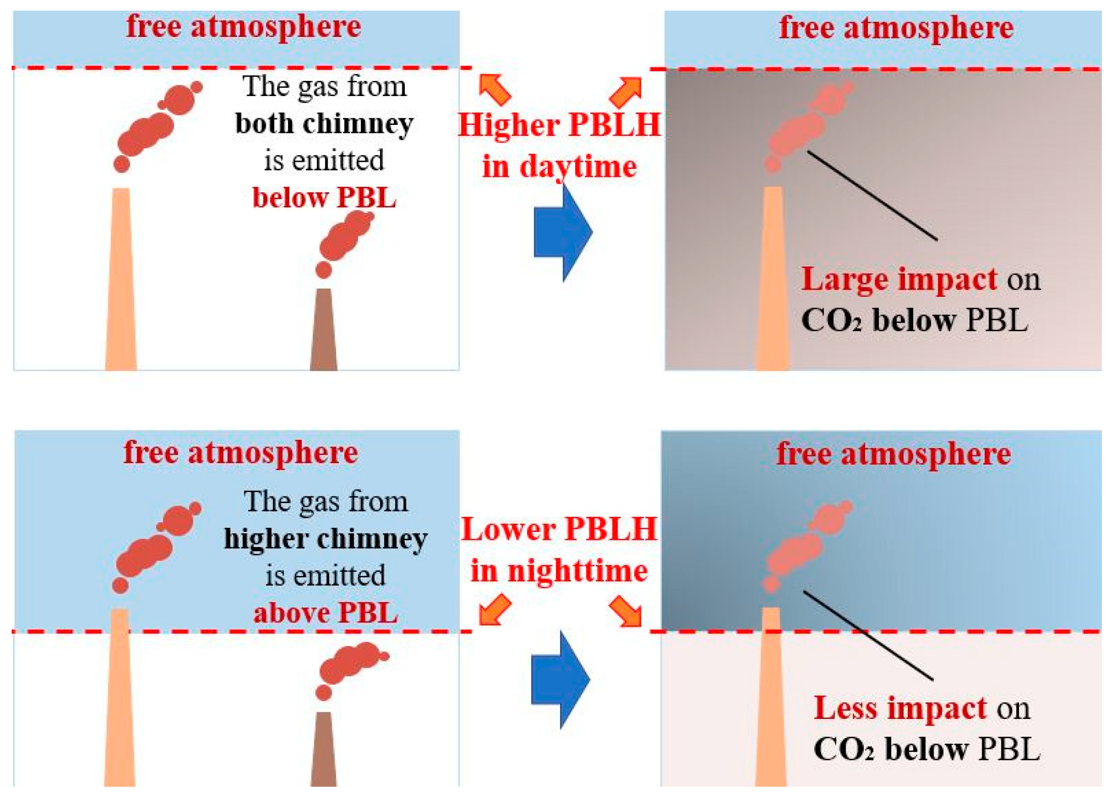
As explained in the Section 1, power stations are among the largest emitters, especially in Chinese megacities, which can emit large amounts of coal burning related CO2 emissions from the chimney at heights of more than 100 m. On the contrary, it is known that PBLH in the winter night can drop to less than 50 m height, and the CO2 emissions from the chimney in these nights are directly emitted to free atmosphere above PBLH, which then will not enhance CO2 concentration within PBLH (Figure 2). However, in the default model framework as STILT, all emission sources are treated at surface level without emission height information, where all CO2 are emitted within PBLH and will inevitably lead to overestimation of simulated CO2, and caused underestimation of posteriori CO2 emissions. In general, the use of midnight CO2 observations/simulations can seriously affect the constraint of regional emissions and lead to mis-understanding of carbon emission information. Here, we revise the emission framework in the STILT model by coupling a dynamic comparison between emission heights and PBLH variations, where we will not assign emissions within PBL when PBLH is lower than chimney height, and vice versa. The simplified expression is displayed in Equation (2).
C O 2 _ e n h a n c e m e n t = { C O 2 _ e n h a n c e m e n t _ s i m ,   P B L H > c h i m n e y   h e i g h t 0 ,         P B L H < = c h i m n e y   h e i g h t
where CO2_enhancement is the simulated CO2 enhancement in revised STILT model framework, CO2_enhancement_sim represents simulated CO2 enhancement when chimney height is lower than PBLH, where that power station locates; and the simulated enhancement will change to 0 when chimney height is higher than PBLH at the same location (Figure 2). The comparisons between PBLH and chimney height are conducted within 168 hours’ (7 days) atmospheric transport process for each hourly CO2 simulation. As mentioned above (Figure 1b), there are three power stations with higher anthropogenic CO2 emission heights in Nanchang.

2.5. Inverse Modeling: Multiplicative Scaling Factor Method

To provide robust results, we applied the multiplicative scaling factor (hereafter MSF) method to constrain total CO2 emissions. This method is widely used because it is simple and effective to use. The posteriori scaling factors (SFs) are obtained by dividing the observed enhancement by the simulated enhancement [21,22],
S F ( C O 2 ) = C O 2 _ o b s C O 2 _ b g Δ C O 2 _ bio Δ C O 2 _ anthro
where SF (CO2) is the posteriori scaling factor, and CO2_obs, CO2_bg, ΔCO2_bio and ΔCO2_anthro are the CO2 concentration observations, background, simulated biological CO2 concentration, and simulated anthropogenic CO2 enhancement, respectively. CO2_obs and CO2_bg were from CO2 observations at our site and WLG background site, ΔCO2_bio and ΔCO2_anthro were from model simulations. The details of how to calculate CO2 obs, CO2 bg, ΔCO2 bio and ΔCO2 anthro are list in details in our previous study [23,24]. We should note the default bias in the a priori EDGAR emissions will also lead to obvious bias in simulated nighttime CO2 concentrations, which can hinder the evaluation of our revised STILT model. Here, to reduce the bias in a priori EDGAR emissions and only focus on improvement in revised STILT model, we will first calibrate CO2 emissions by only using daytime CO2 observations and MSF method.
Therefore, we will obtain three different simulations, as simulations 1 and 2 combined form the a priori EDGAR by using the “default model” and the “revised model”, respectively; we also obtained simulation 3 by combining the posteriori EDGAR with the revised models. (1) The comparison between simulation 1 and 2 can give us a first glance whether the “revised model” can improve the nighttime model simulations even using a priori emissions; (2) a comparison between simulation 2 and 3 provides an overall assessment of the a priori EDGAR bias on model improvements.

3. Results and Discussions

3.1. Comparison of Observed and Simulated CO2 Concentration Using Default and Revised Model Frameworks

The simulated hourly footprint from January to April was averaged and displayed in Figure 3, which shows the general shape of northeast to southwest. The intense source regions (<10−3 ppm·m2·s·mol−1) covers Nanchang city and northeast part of Jiangxi province, indicating the tower-based CO2 concentrations will be dominated by emissions within this area. To quantify source contributions from Nanchang city and surrounding provinces, we also displayed contributions from simulated monthly averaged enhancements as a list in Table 1. It shows contributions from different regions largely varied in each month, where contributions from Nanchang city varied from 43.2% in January to 66.7% in March with averages of 53.2%, and surrounding provinces also contributed obvious enhancements, with Hubei, Anhui and Jiangsu of 9.5%, 7.6%, and 6.1%, respectively. These results indicated emissions within Nanchang city contributed the most to atmospheric CO2 at the observation site.
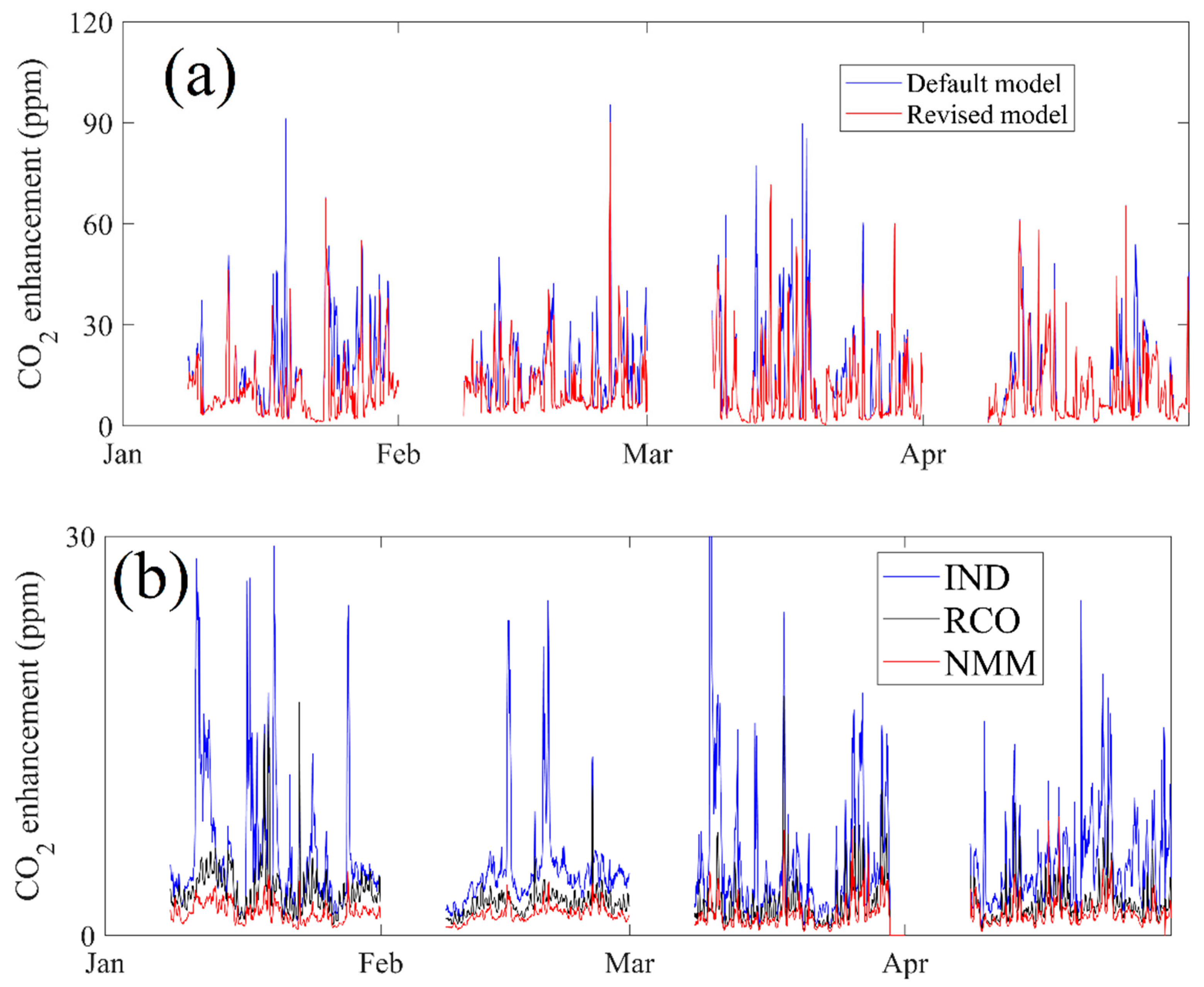
The hourly CO2 concentrations from January to April 2019 were then simulated by WRF-STILT model using the “default” and “revised” framework, and both simulations were compared with observations as displayed in Figure 4a. Note there are four gaps in Figure 4a, which is caused because the simulation of any hourly CO2 in WRF-STILT model requires an accumulated CO2 enhancement of the past 168 h. Hence, the revised model also requires a comparison of 168 (7 days) hourly varied PBLH with emission heights, and only the days since the 8th day in each month were compared with observations. We first compared the default model simulations with observations, which showed that the model performed generally well in simulating the hourly variation pattern of CO2, where the root mean standard error (RMSE), mean bias (MB) and correlation coefficient (R) were 17.8 ppm, 13.0 ppm, and 0.23, respectively. However, the default framework also indicates that there are many spikes (>500 ppm) that seem unreasonably overestimated. Furthermore, we compared the simulated CO2 concentration between using default and revised frameworks, it is obvious that most spikes were calibrated down in the revised framework with the RMSE, MB and R of 16.6 ppm, 12.4 ppm and 0.25, respectively, where dynamic PBLH variations have been coupled with chimney heights. We need to point out that revised model cannot lead to higher spikes than default model, but the Figure 4a may lead to the misunderstanding that the revised model caused more spikes where the default model did not have for some specific days, which is caused because the red line (revised model) must have covered the blue line (default model). We should note that the statistical data using the revised framework does not significantly improve when compared with using the default framework, which can be explained by the following: (1) the revised model mainly improve nighttime simulations when PBLH drop blow chimney height, which only occurred in some nights with stratification stability (i.e., improvement reaches to larger than 50 ppm at some nights in middle of January and March), hence the overall statistical data for all 4 months will not display obvious improvements; (2) the simulated bias in default framework can be caused by both bias in a priori CO2 emissions and without considering emission heights. We will further use calibrated emissions to simulate and evaluate CO2 concentrations as discussed later.
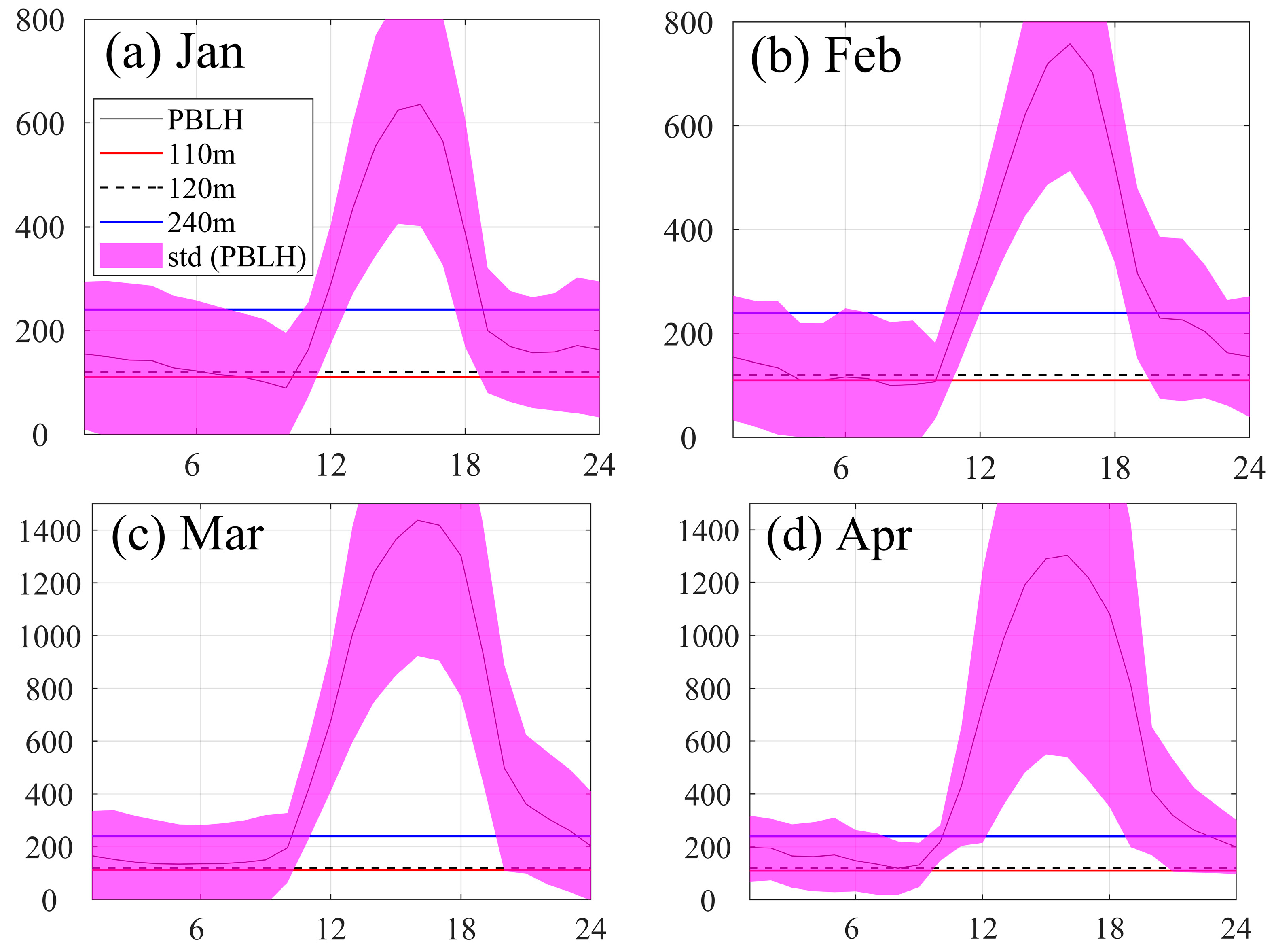
To further analyze how the revised model affected the simulation of atmospheric CO2 concentration, the WRF model simulated hourly PBLH, displayed in Figure 4b, is also compared with the heights of three power stations in Nanchang city. It is obvious that the PBLH occurs periodically below the stack heights, especially during the nighttime when compared with the highest chimney height of 240 m; similar situations almost happened from January to April. As explained above for the real conditions, CO2 plume from the highest power stations will be directly emitted in free atmosphere instead of PBLH when nighttime PBLH decrease to less than 240 m, and CO2 concentrations within PBLH cannot reach high values. In the default framework, a large overestimation will be caused because all CO2 emissions are at ground level, and will directly enhance CO2 concentrations within PBLH. In the revised STILT model, it considered the emission height and excluded CO2 enhancement when PBLH decreased to below chimney height (as of 110 m, 120 m, and 240 m in this study) during the 168 h of simulated air particles movement period.
It is obvious that the revised model considerably corrected the abnormally high CO2 spikes when the PBLH is lower than the chimney height. However, for a small fraction of the anomalously high values, the revised model failed to capture and correct them. This is because the hourly PBLH values used in this study were from WRF model simulations rather than true observations, and the uncertainty brought by the simulated PBLH obviously affected the effectiveness of the revised model for CO2 simulations to a large extent, so we also strongly suggest that the PBLH observations should be used in following studies, which can further improve model simulations in nighttime.
As introduced in the Section 2, the simulated CO2 concentration contains CO2 background value, enhancement contributions from different anthropogenic categories and plants NEE. In the whole study period, the simulated CO2 enhancements from anthropogenic sources were 26.80 ppm for the default model and 22.02 ppm for the revised model, respectively; the enhancement contribution from NEE did not change as of 1.88 ppm, so the main CO2 enhancement contribution came from anthropogenic categories. Considering that the only difference was from ENE (power stations) with chimney height, and also to further analyze the magnitude of the contributions from different anthropogenic categories, we compared the simulated ENE enhancements using the default and revised frameworks in Figure 5a, and the enhancements from other main contributions were also displayed in Figure 5b. It shows that ENE accounts for the majority of all anthropogenic enhancement, followed by IND (manufacture industry), RCO (energy for building), and NMM (cement production). The enhancement contributions from ENE decreased from 15.43 ppm when using the default framework to 10.65 ppm by using the revised framework, with a relative decrease of 31.0%, while the other components remained unchanged between the two frameworks as of 5.50 ppm, 2.67 ppm, and 1.65 ppm for IND, RCO, and NMM, respectively. We also note that when we compared the simulated CO2 concentration in Figure 4a with the ENE enhancement in Figure 5a, it shows there is strong consistency in the timing of the occurrence of anomalously spikes for both of them, indicating that the nighttime overestimations of CO2 were mainly from the inaccuracy of the simulated ENE enhancement.
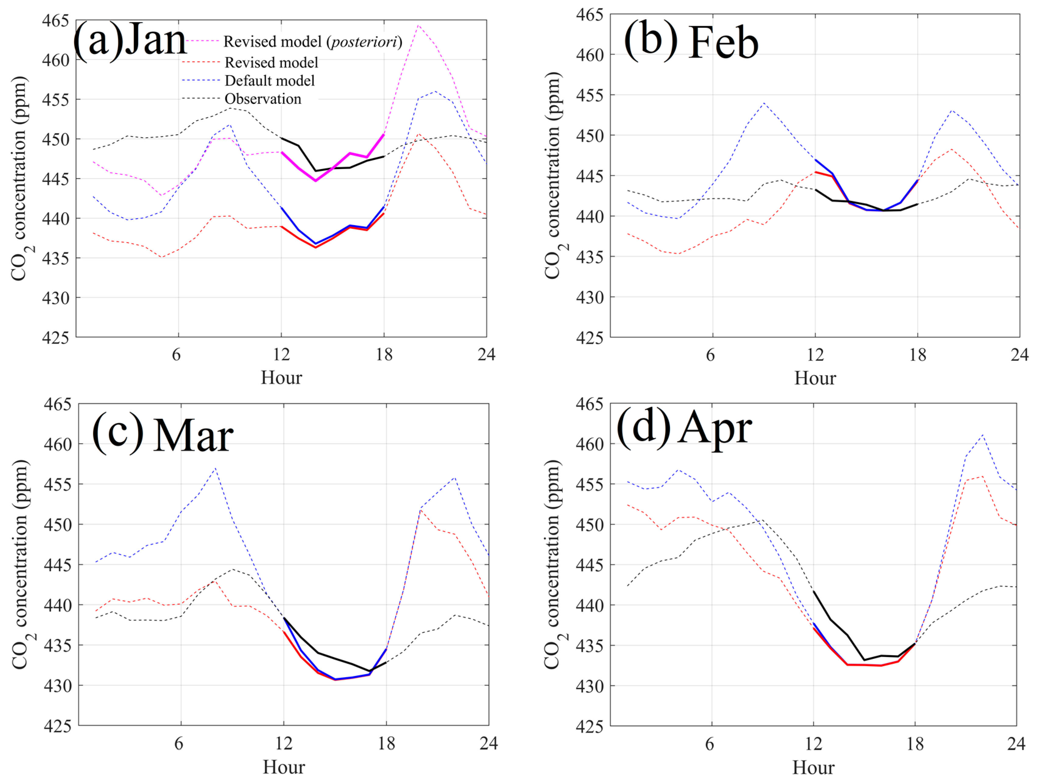
To analyze the model improvement for both nighttime and daytime simulations, the monthly averaged diurnal variations between observations and simulations are displayed in Figure 6. It can be found that the improvement mainly occurs between 20:00 at night and 8:00 in the morning, and without obvious changes from 12:00 to 18:00. This can be explained because the boundary layer height decays and drops down significantly in the nighttime without sun-induced heating from the surface. In some specific days for winter nights, PBLH can even drop below 50 m, which is much lower than chimney height (Figure 7). In general, the proportions of hourly PBLH lower than corresponding heights of three power stations were 35.8–58.5%, 33.9–52.6%, 27.8–43.9%, 22.7–43.1% in January, February, March, April, respectively, indicating the gradual decreasing influence of lower PBLH in these four months. The CO2 concentration in default framework shows unreasonably high spikes between 9:00~10:00 and 20:00~21:00 in all months, with amplitudes of diurnal variations reaching 19.2 ppm in January, 14.3 ppm in February, 26.2 ppm in March and 28.6 ppm in April. In the revised model, the amplitudes of diurnal variations decreased to 15.7 ppm in January, 12.9 ppm in February, 21.1 ppm in March and 23.5 ppm in April, which were much closer with observations as of 7.9 ppm, 3.9 ppm, 12.6 ppm, and 17.3 ppm. We note the overestimation between 18:00 and 24:00 contributed the most to discrepancy with observations, which can be caused by simulated PBLH bias during this period as explained below. The monthly averaged diurnal variations for PBLH were also displayed in Figure 7, that PBLH was higher than 240 m mainly from 10:00 to 20:00 and from 6:00 to 8:00. It supports the conclusions that our revised model will have the largest influence on simulated CO2 from 6:00 to 8:00. In general, the diurnal comparisons indicate that the revised model can effectively correct the problem of high CO2 concentration spikes at night.
However, we should also note that the general model performance largely varies in each month, especially for January, where even the revised model was much lower than observations for all 24 h (Figure 6a). As noted above, the bad performance can be caused by bias in (1) a priori emissions, (2) meteorological fields, and (3) model ability especially for emission heights information. Our previous study has evaluated that the WRF parameterization scheme performed well in simulating meteorological field [23,24]. If we choose the daytime comparisons between simulations and observations to evaluate bias in a priori emissions [21,22], considerable underestimation of CO2 emissions is indicated in January. These daytime comparisons in February, March and April in Figure 5 indicate only a slight bias for a priori EDGAR emissions. Hence, we believe the bias in EDGAR emissions for January should be the main reason of underestimation not only at nighttime but also in daytime. By using the MSF method to constrain CO2 emissions, we found the a priori emission was underestimated by 37.8% when compared with derived posteriori emissions in January. We re-simulated CO2 concentration by using posteriori emission and the revised model, with results displayed in Figure 6a, which show an underestimation in both daytime and nighttime was calibrated and simulations are highly consistent with observations.
We should also note the traditional 2019 Spring Festival was held in February, during which almost all factories will reduce their production and corresponding CO2 emissions, and traffic in cities will also reduce CO2 emissions because most local residents will stay home or have already moved to the rural area. These above reasons also make the atmospheric CO2 variations in February beyond the scope of ability in the WRF-STILT model and a priori emissions. The simulated diurnal variations in March and April considerably reduced the overestimation before 10:00, and were close to observations. However, we also found the overestimations between 18:00 and 24:00 were not calibrated as stated above, which was caused by (1) simulated CO2 concentration was accumulated in 7 days, and even the PBLH decreased to below chimney height after 18:00, the accumulated CO2 enhancement before 18:00 still contributed obvious enhancements to CO2 simulations after 18:00; (2) the diurnal variations of main emission categories used in this study cannot well represent the real conditions, where much lower emissions should be assigned during 18:00–24:00; (3) potential large bias in simulated PBLH between 18:00 and 24:00, and although the monthly averaged PBLH diurnal variations was higher than 240 m (Figure 7c,d), the PBLH can also reached lower than 240 m for some days in these two months. Moreover, as mentioned above that the used PBLH in the revised model was from simulations instead of observations, where potential bias in simulated PBLH variations can lead to large bias in CO2 simulations.

3.2. Influence of a priori Emission Bias on Simulated Atmospheric CO2 Concentration

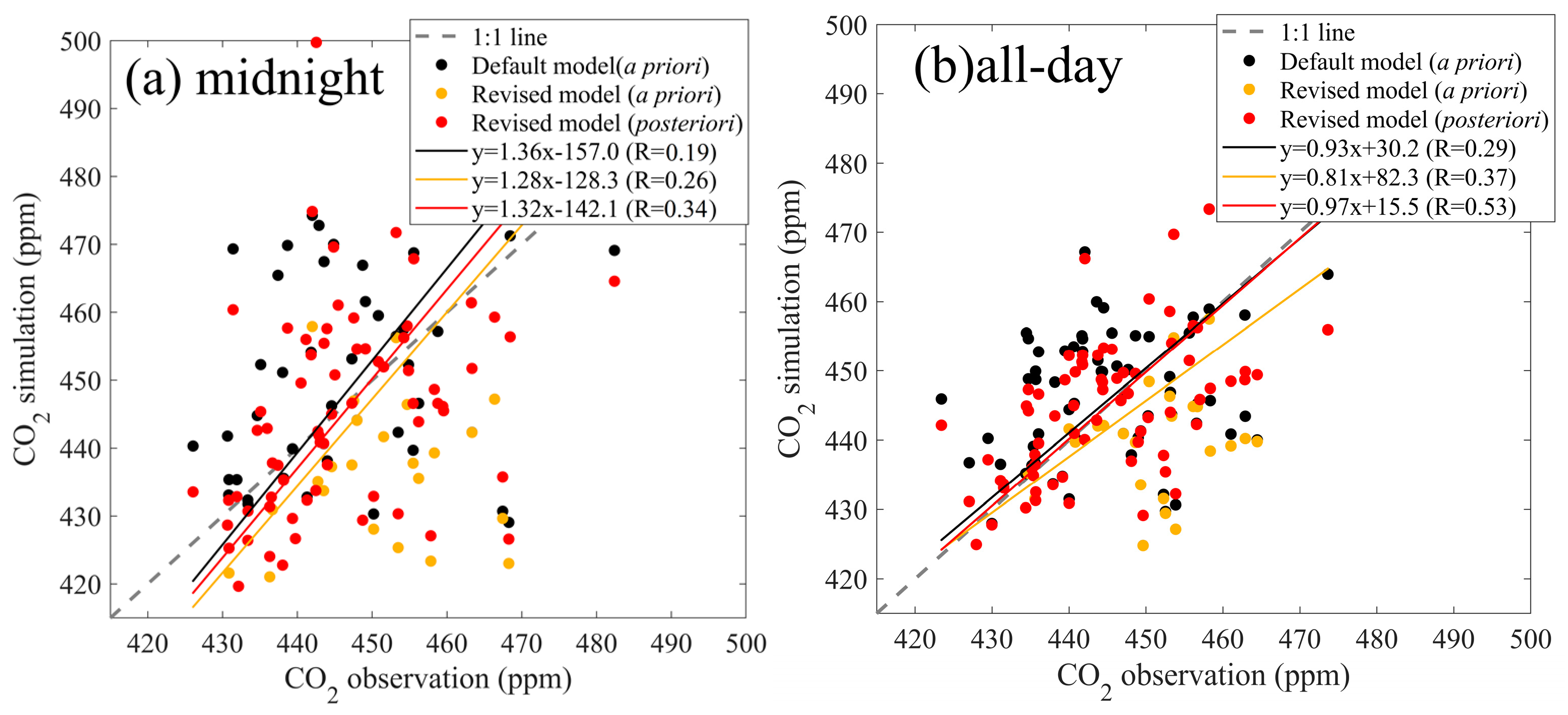
The performance of simulated CO2 concentration not only depends on the model framework, but also potential emission bias. In order to fully display the improvement of the revised model, it is necessary to consider the influence of a priori emission bias and use calibrated posteriori emissions. As partly discussed above, we used the scaling factor of 1.378 to derive posteriori emissions in January, and analyze all simulations throughout the study period except February. Since the CO2 simulation at nighttime is considered to be more challenging, and to demonstrate the performance of the revised model improvements in this study, statistical data (Table 2) including RMSE, MB, and R at nighttime were calculated between hourly observations and three different simulations including default model (a priori), revised model (a priori), and revised model (posteriori). It shows that the RMSE, MB and R in revised model (posteriori EDGAR) were 17.5 ppm, −0.9 ppm, and 0.29, which considerably improved from the default model (a priori EDGAR) as 19.2 ppm, 1.7 ppm and 0.17, and also improved compared with from revised model (a priori EDGAR) to 18.1 ppm, −3.7 ppm and 0.23. The statistics for daily averages were also displayed in Table 3 for midnight and all-day, which also showed the performance of using revised model (posteriori EDGAR) largely improved, especially for the MB and R, where the MB decreased to −1.0 ppm from 1.6 and −4.0 ppm in midnight, and MB decreased to 0.1 ppm from 0.7 and −3.3 ppm. The R value improved to 0.34 from 0.19 and 0.26 for midnight, and improved to 0.53 from 0.29 and 0.34.
The scatter plots of midnight and daily averages between observations and simulations were also displayed in Figure 8, and three different simulations are illustrated. For the midnight average in Figure 8a, it shows the scatter plots of the revised model (posteriori) were much closer to the 1:1 line, and the R value obviously improved from the other two simulations, indicating it can better simulate the temporal variations. For the daily average in Figure 8b, it shows the regression slope was 0.93 for default model using a priori emissions, and decreased to 0.81 for revised model using the same a priori emissions, indicating the bias in a priori leads to much larger bias. However, the R value increased from 0.29 to 0.37, illustrating the revised model can better capture the daily variations than default model. When we used the revised model and posteriori emissions to simulate CO2 concentrations, the slope and R value largely improved to 0.97 and 0.53, respectively, and its intercept also decreased. We should note there were slight underestimations the concentrations for midnight and overestimations for daily averages by a few ppm (Figure 8), which can also be caused by background bias where we only used one background site without considering the daily background variations. Hourly varied CO2 background should be considered with data from global CO2 distributions as our previous study [25]. In general, this considerable improvement further indicates our revised model obviously calibrated the bias in daily variations.

3.3. Implication of Model Improvement on Inversion Studies

The application of the revised WRF-STILT model at night starts with the accurate setting of the emission heights, and we will discuss more of the advantages of the revised model, the range of adaptation area and possible sources of uncertainty. In this study, it was found that the simulated nighttime CO2 enhancement by using the revised model and posteriori EDGAR emissions can decrease the overestimation by an average of 5.2 ppm at night. This study was mainly conducted in winter, during which the PBLH can frequently decrease to less than 50 m and enhance many high CO2 spikes during nighttime. After using the revised model and posteriori emissions, the model only slightly underestimated nighttime CO2 concentration by 0.9 ppm, which greatly reduces the MB of 3.7 ppm when using a priori emissions. It indicates the importance of accurate emissions in well reflecting the model improvement. In addition, the advantage of our revised model than Maier’s “volume source influence” approach is that our strategy coupled the dynamic PBLH and several emission source height, which does not need too much extra computational resources [13]. In addition, compared to Maier’s “volumetric source impact” method, the revised framework used in this study also has the advantage that coupling dynamic PBLH observations, which can improve model simulations much more. Moreover, many other available PBLH products (i.e., from different reanalysis products) can also be used in the revised WRF-STILT model to quantify the potential influence of PBLH in simulating CO2 concentrations.
Another advantage of this revised model is that we can update emission heights and locations offline, especially for super emitters as power stations, which accounted for nearly half of urban total emissions. Here, in this study, power stations need to be mainly considered because of the use of high stacks, and it accounted for 47% of total anthropogenic emissions in Nanchang city, the better simulation of CO2 enhancement from power stations directly influence emission inversions using all hourly observations. At the same time, the application of the revised framework only needs emission height information of several grid points.
Most of previous top-down based atmospheric inversion approaches chose to use daytime and all-day CO2 observations in constraining its emissions [7,8,9,26]. There is a large issue when deciding whether nighttime CO2 observations should be used, and (1) the excluding of nighttime CO2 observations will rule out valuable emission information during nighttime, because only using daytime observations cannot represent diurnal variations of emissions; (2) if nighttime CO2 concentrations are included in emission inversion studies, the lower PBLH and higher emission heights will lead to overestimation of simulated atmospheric CO2 concentration, which will conversely cause underestimation of posteriori emissions. Hence, the emission heights should be coupled in models to better calibrate related nighttime spikes, especially in winters. For the inversion of plants NEE, the model without emission height will also lead to underestimation of plants respiration, and even misunderstand the forest as carbon sinks when considering daytime uptakes [23,27,28].
Our findings for the Lagrangian STILT model are also consistent with Geels et al. [10], who used five different Eulerian atmospheric transport models to simulate CO2 concentrations from different locations in Europe, which used continuous CO2 observations to assess the capability of each model. Their study showed that model predictions are significantly better in the afternoon under well-mixed atmospheric conditions than under stable nighttime conditions, and therefore suggests using only afternoon values to constrain the sources or sinks of CO2. Brunner et al. [11] also found emission heights were less important during well mixed boundary layer conditions when PBLH is much higher than emission heights. However, as suggested above, using only afternoon values or daytime data would ignore the diurnal variations of CO2 sources/sinks, which will likewise have a large impact on the emission inversion results. Moreover, the “aggregation error” and “representation error” should also be considered in nighttime because CO2 observations can more be influenced by nearby emission sources, and finer spatial resolutions (i.e., a few km) of inventories and model setup can largely reduce the influence of these “errors” on concentration simulation and emission inversions [12,29,30]. From the limitations of the above two model frameworks, it is still necessary to further improve the nighttime simulation and add the nighttime data in the inversion framework. To further realize the availability of nighttime observations, it is strongly recommended to use the revised WRF-STILT model and observed PBLH variations in future inversion studies, which can effectively reduce the appearance of nighttime spikes.

4. Conclusions

The WRF-STILT model has been widely applied in greenhouse gas emission inversions by the use of atmospheric observations, while the missing of emission height has been found to overestimate nighttime concentration and underestimate posteriori emissions. The above issue leads to the difficulty that recent atmospheric inversion research only chooses daytime concentration observations to constrain its emissions. To address this issue, we conducted four months of atmospheric CO2 observations from January to April, 2019, which was measured at the tower at the height of 50 m. We then raised a revised model framework which coupled emission heights with dynamic PBLH variations, this method significantly reduced overestimations in nighttime. We found the following:
(1) The overestimation of simulated nighttime CO2 concentration decreased by 5–10 ppm, especially between 0:00 and 7:00 in the revised model; the statistics for nighttime simulations largely improved by using revised framework and posteriori emissions, with good performance when compared with default model, it indicated nighttime CO2 simulation bias was largely calibrated when using revised model.
(2) The regression slopes (and R) for daily averaged concentrations were 0.93 (0.29) and 0.81 (0.37) for default model using a priori emissions, and revised model using the same a priori emissions, and the slope largely improved to 0.97 (0.53). These slopes together with improved correlation coefficient indicate our revised model and posteriori emissions obviously calibrated the bias in daily variations. The scatter plots for nighttime averages and correlation coefficient also indicate large improvement for revised model.
In general, it is strongly recommended to use the revised WRF-STILT model in future inversion studies, which can effectively reduce the overestimation of nighttime spikes and make full use of nighttime observations.

Author Contributions

C.H. designed the study, performed the model simulation, Y.P. wrote the draft under supervision of C.H. Y.P., C.H., X.A., Y.L., L.G., H.L., J.Z. and W.X. contributed to the data/figures preparation and analysis. All authors have read and agreed to the published version of the manuscript.

Funding

Cheng Hu is supported by the National Science founding of China (grant no. 42105117), and the Natural Science Foundation of Jiangsu Province (grant no. BK20200802). Wei Xiao is supported by the National Key R&D Program of China (grants 2020YFA0607501 & 2019YFA0607202), Yiyi Peng is also partly supported by Higher school in jiangsu province college students’ practice innovation training programs from Nanjing Forestry University (202210298148Y).

Institutional Review Board Statement

Not applicable.

Informed Consent Statement

Not applicable.

Data Availability Statement

The atmospheric CO2 observations data can be requested from Cheng Hu. EDGAR CO2 emission inventories can be downloaded from https://edgar.jrc.ec.europa.eu/ (accessed on 1 June 2022), STILT model is downloaded from http://www.stilt-model.org/ (accessed on 27 December 2022).

Conflicts of Interest

The authors declare no conflict of interest.

References

  1. Satterthwaite, D. Cities’ contribution to global warming: Notes on the allocation of greenhouse gas emissions. Environ. Urban. 2008, 20, 539–549. [Google Scholar] [CrossRef] [Green Version]
  2. Xu, J.; Lee, X.; Xiao, W.; Cao, C.; Liu, S.; Wen, X.; Xu, J.; Zhang, Z.; Zhao, J. Interpreting the 13C/12C ratio of carbon dioxide in an urban airshed in the Yangtze River Delta, China. Atmos. Chem. Phys. 2017, 17, 3385–3399. [Google Scholar] [CrossRef] [Green Version]
  3. Ciais, P.; Paris, J.D.; Marland, G.; Peylin, P.; Piao, S.L.; Levin, I.; Pregger, T.; Scholz, Y.; Friedrich, R.; Rivier, L.; et al. The European carbon balance. Part 1: Fossil fuel emissions. Glob. Change Biol. 2009, 16, 1395–1408. [Google Scholar] [CrossRef]
  4. Gately, C.K.; Hutyra, L.R.; Wing, I.S. Cities, traffic, and CO2: A multidecadal assessment of trends, drivers, and scaling relationships. Proc. Natl. Acad. Sci. USA 2015, 112, 4999–5004. [Google Scholar] [CrossRef] [Green Version]
  5. Gately, C.K.; Hutyra, L.R. Large uncertainties in urban-scale carbon emissions. J. Geophys. Res. Atmos. 2017, 122, 11–242. [Google Scholar] [CrossRef]
  6. Boon, A.; Broquet, G.; Clifford, D.J.; Chevallier, F.; Butterfield, D.M.; Pison, I.; Ramonet, M.; Paris, J.D.; Ciais, P. Analysis of the potential of near-ground measurements of CO2 and CH4 in London, UK, for the monitoring of city-scale emissions using an atmospheric transport model. Atmos. Chem. Phys. 2016, 16, 6735–6756. [Google Scholar] [CrossRef] [Green Version]
  7. Staufer, J.; Broquet, G.; Bréon, F.M.; Puygrenier, V.; Chevallier, F.; Xueref-Rémy, I.; Dieudonné, E.; Lopez, M.; Schmidt, M.; Ramonet, M.; et al. The first 1-year-long estimate of the Paris region fossil fuel CO2 emissions based on atmospheric inversion. Atmos. Chem. Phys. 2016, 16, 14703–14726. [Google Scholar] [CrossRef] [Green Version]
  8. Turner, A.J.; Kim, J.; Fitzmaurice, H.; Newman, C.; Worthington, K.; Chan, K.; Wooldridge, P.J.; Köehler, P.; Frankenberg, C.; Cohen, R.C. Observed Impacts of COVID-19 on Urban CO2 Emissions. Geophys. Res. Lett. 2020, 47, e2020GL090037. [Google Scholar] [CrossRef]
  9. Hu, C.; Griffis, T.J.; Xia, L.; Xiao, W.; Liu, C.; Xiao, Q.; Huang, X.; Yang, Y.; Zhang, L.; Hou, B. Anthropogenic CO2 emission reduction during the COVID-19 pandemic in Nanchang City, China. Environ. Pollut. 2022, 309, 119767. [Google Scholar] [CrossRef]
  10. Geels, C.; Gloor, M.; Ciais, P.; Bousquet, P.; Peylin, P.; Vermeulen, A.T.; Dargaville, R.; Aalto, T.; Brandt, J.; Christensen, J.H.; et al. Comparing atmospheric transport models for future regional inversions over Europe—Part 1: Mapping the atmospheric CO2 signals. Atmos. Chem. Phys. 2007, 7, 3461–3479. [Google Scholar] [CrossRef]
  11. Brunner, D.; Kuhlmann, G.; Marshall, J.; Clément, V.; Fuhrer, O.; Broquet, G.; Löscher, A.; Meijer, Y. Accounting for the vertical distribution of emissions in atmospheric CO2 simulations. Atmos. Chem. Phys. 2019, 19, 4541–4559. [Google Scholar] [CrossRef] [Green Version]
  12. Wang, Y.; Wang, X.; Wang, K.; Chevallier, F.; Zhu, D.; Lian, J.; He, Y.; Tian, H.; Li, J.; Zhu, J.; et al. The size of the land carbon sink in China. Nature 2022, 603, E7–E9. [Google Scholar] [CrossRef] [PubMed]
  13. Maier, F.; Gerbig, C.; Levin, I.; Super, I.; Marshall, J.; Hammer, S. Effects of point source emission heights in WRF–STILT: A step towards exploiting nocturnal observations in models. Geosci. Model Dev. 2022, 15, 5391–5406. [Google Scholar] [CrossRef]
  14. Fang, S.X.; Zhou, L.X.; Tans, P.P.; Ciais, P.; Steinbacher, M.; Xu, L.; Luan, T. In situ measurement of atmospheric CO2 at the four WMO/GAW stations in China. Atmos. Chem. Phys. 2014, 14, 2541–2554. [Google Scholar] [CrossRef] [Green Version]
  15. Pang, J.; Wen, X.; Sun, X. Mixing ratio and carbon isotopic composition investigation of atmospheric CO2 in Beijing, China. Sci. Total Environ. 2016, 539, 322–330. [Google Scholar] [CrossRef] [PubMed]
  16. Guo, J.; Zhang, J.; Yang, K.; Liao, H.; Zhang, S.; Huang, K.; Lv, Y.; Shao, J.; Yu, T.; Tong, B.; et al. Investigation of near-global daytime boundary layer height using high-resolution radiosondes: First results and comparison with ERA5, MERRA-2, JRA-55, and NCEP-2 reanalyses. Atmos. Chem. Phys. 2021, 21, 17079–17097. [Google Scholar] [CrossRef]
  17. Lin, J.C. A near-field tool for simulating the upstream influence of atmospheric observations: The Stochastic Time-Inverted Lagrangian Transport (STILT) model. J. Geophys. Res. 2003, 108, 4493. [Google Scholar] [CrossRef] [Green Version]
  18. Stein, A.F.; Draxler, R.R.; Rolph, G.D.; Stunder, B.J.B.; Cohen, M.D.; Ngan, F. NOAA’s HYSPLIT Atmospheric Transport and Dispersion Modeling System. Bull. Am. Meteorol. Soc. 2015, 96, 2059–2077. [Google Scholar] [CrossRef]
  19. Janssens-Maenhout, G.; Crippa, M.; Guizzardi, D.; Muntean, M.; Schaaf, E.; Dentener, F.; Bergamaschi, P.; Pagliari, V.; Olivier, J.; Peters, J.; et al. EDGAR v4.3.2 Global Atlas of the three major Greenhouse Gas Emissions for the period 1970–2012. Earth Syst. Sci. Data 2019, 11, 959–1002. [Google Scholar] [CrossRef] [Green Version]
  20. Crippa, M.; Solazzo, E.; Huang, G.; Guizzardi, D.; Koffi, E.; Muntean, M.; Schieberle, C.; Friedrich, R.; Janssens-Maenhout, G. High resolution temporal profiles in the emissions database for global atmospheric research. Sci. Data 2020, 7, 121. [Google Scholar] [CrossRef]
  21. Sargent, M.; Barrera, Y.; Nehrkorn, T.; Hutyra, L.R.; Gately, C.K.; Mckain, K.; Sweeney, C.; Hegarty, J.; Hardiman, B.; Steven, C.; et al. Anthropogenic and biogenic CO2 fluxes in the Boston urban region. Proc. Natl. Acad. Sci. USA 2018, 115, 7491–7496. [Google Scholar] [CrossRef] [PubMed] [Green Version]
  22. He, J.; Naik, V.; Horowitz, L.W.; Dlugokencky, E.; Thoning, K. Investigation of the global methane budget over 1980–2017 using GFDL-AM4.1. Atmos. Chem. Phys. 2020, 20, 805–827. [Google Scholar] [CrossRef] [Green Version]
  23. Hu, C.; Griffis, T.J.; Liu, S.; Xiao, W.; Hu, N.; Huang, W.; Yang, D.; Lee, X. Anthropogenic Methane Emission and Its Partitioning for the Yangtze River Delta Region of China. J. Geophys. Res. Biogeosci. 2019, 124, 1148–1170. [Google Scholar] [CrossRef]
  24. Hu, C.; Xu, J.; Liu, C.; Chen, Y.; Yang, D.; Huang, W.; Deng, L.; Liu, S.; Griffis, T.J.; Lee, X. Anthropogenic and natural controls on atmospheric δ13C-CO2 variations in the Yangtze River delta: Insights from a carbon isotope modeling framework. Atmos. Chem. Phys. 2021, 21, 10015–10037. [Google Scholar] [CrossRef]
  25. Hu, C.; Grif, T.J.; Millet, D.B. Top-Down Constraints on Anthropogenic CO2 Emissions Within an Agricultural-Urban Landscape. J. Geophys. Res. Atmos. 2018, 123, 4674–4694. [Google Scholar] [CrossRef]
  26. Kountouris, P.; Gerbig, C.; Rödenbeck, C.; Karstens, U.; Koch, T.F.; Heimann, M. Technical Note: Atmospheric CO2 inversions on the mesoscale using data-driven prior uncertainties: Methodology and system evaluation. Atmos. Chem. Phys. 2018, 18, 3027–3045. [Google Scholar] [CrossRef] [Green Version]
  27. Peters, W.; Jacobson, A.R.; Sweeney, C.; Andrews, A.E.; Conway, T.J.; Masarie, K.; John, B.M.; Lori MP, B.; Gabrielle, P.; Adam, I.H.; et al. An atmospheric perspective on North American carbon dioxide exchange: CarbonTracker. Proc. Natl. Acad. Sci. USA 2007, 104, 18925–18930. [Google Scholar] [CrossRef] [Green Version]
  28. Zhang, H.F.; Chen, B.Z.; van der Laan-Luijkx, I.T.; Chen, J.; Xu, G.; Yan, J.W.; Zhou, L.X.; Fukuyama, Y.; Tans, P.P.; Peters, W. Net terrestrial CO2 exchange over China during 2001–2010 estimated with an ensemble data assimilation system for atmospheric CO2. J. Geophys. Res. Atmos. 2014, 119, 3500–3515. [Google Scholar] [CrossRef] [Green Version]
  29. Zhao, C.; Andrews, A.E.; Bianco, L.; Eluszkiewicz, J.; Hirsch, A.; MacDonald, C.; Nehrkorn, T.; Fischer, M.L. Atmospheric inverse estimates of methane emissions from Central California. J. Geophys. Res. 2009, 114, D16302. [Google Scholar] [CrossRef]
  30. Turner, A.J.; Jacob, D.J. Balancing aggregation and smoothing errors in inverse models. Atmos. Chem. Phys. 2015, 15, 7039–7048. [Google Scholar] [CrossRef]
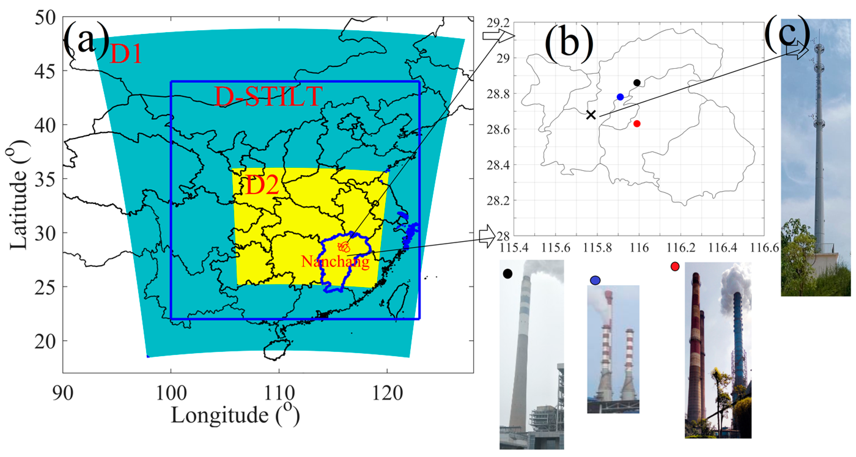
Figure 1. (a) WRF-STILT model setup, (b) the location of tower site and three power industry related “super” emitters by coal combustion, and (c) tall tower, note the boundary of Nanchang city is displayed in red line in panel a, the symbol “×” in panel b represents tower site, and three dots in different colors are “super emitters” with photos also displayed below.
Atmosphere 14 00223 g001
Figure 2. Revised model framework in simulating atmospheric CO2 concentration by coupling dynamic PBLH variations and chimney height.
Atmosphere 14 00223 g002
Figure 3. Averaged footprint from January to April, 2019, Jiangxi and the surrounding provinces are also labeled in yellow color, the observation site is represented using green “×”, the units for footprint: log10 (ppm·m2·s·mol−1). Note the color bar represents different level of intensity of each footprint, with the red color being larger than the following colors.
Atmosphere 14 00223 g003
Figure 4. (a) Comparisons between hourly CO2 concentrations and simulations (using both default and revised frameworks), and (b) the averages of hourly variations of simulated PBLH at three power station sites and the heights at three power stations, note the PBLH larger than 1000 m is not shown.
Atmosphere 14 00223 g004
Figure 5. (a) Time series of CO2 enhancements from ENE (power stations) by using default model framework and revised framework, (b) CO2 enhancement contributions from IND (manufacture industry), RCO (energy for building), and NMM (cement production).
Atmosphere 14 00223 g005
Figure 6. Monthly averaged diurnal variations of CO2 concentrations comparisons in (a) January, (b) February, (c) March, and (d) April, the bold line represents daytime period (12:00–18:00, local time), “posteriori” in panel a indicates simulations using the posteriori emissions constrained by MSF method.
Atmosphere 14 00223 g006
Figure 7. Monthly averaged diurnal variations of PBLH in (a) January, (b) February, (c) March, and (d) April. The shade is standard deviation for PBLH.
Atmosphere 14 00223 g007
Figure 8. Scatter plots of (a) midnight and (b) daily CO2 average between observations and simulations, note simulations from the default model (using a priori emissions), revised model (using a priori emissions), and revised model (using posteriori emissions) are compared.
Atmosphere 14 00223 g008
Table 1. Proportions of enhancement contribution from different provinces and Nanchang city, note Jiangxi province contains Nanchang city.
Source AreaJiangxiNanchangHubeiAnhuiJiangsuZhejiangHebeiHunanGuangdongFujianOthers
January49.1%43.2%14.8%11.1%7.1%1.6%1.4%0.4%0.0%0.1%14.4%
February50.4%44.8%6.6%10.8%10.4%2.8%2.5%0.8%0.7%0.4%14.7%
March72.4%66.7%9.4%4.6%2.7%1.4%0.6%0.8%0.5%0.3%7.3%
April67.9%58.1%7.0%3.9%4.1%2.8%0.2%1.7%2.3%1.0%9.2%
Table 2. Statistics for different simulation cases for hourly CO2 during midnight.
RMSEMBR
Default model (a priori EDGAR)19.21.70.17
Revised model (a priori EDGAR)18.1−3.70.23
Revised model (posteriori EDGAR)17.50.90.29
Table 3. Statistics for different simulation cases for daily CO2 during midnight and all-day.
MidnightAll-Day
RMSEMBRRMSEMBR
Default model (a priori EDGAR)2941.60.19136.40.70.29
Revised model (a priori EDGAR)263.1−4.00.26118.9−3.30.37
Revised model (posteriori EDGAR)231.9−1.00.3492.50.10.53
Disclaimer/Publisher’s Note: The statements, opinions and data contained in all publications are solely those of the individual author(s) and contributor(s) and not of MDPI and/or the editor(s). MDPI and/or the editor(s) disclaim responsibility for any injury to people or property resulting from any ideas, methods, instructions or products referred to in the content.