
Study on Risk Prediction Model of Expressway Agglomerate Fog-Related Accidents

Abstract
:1. Introduction
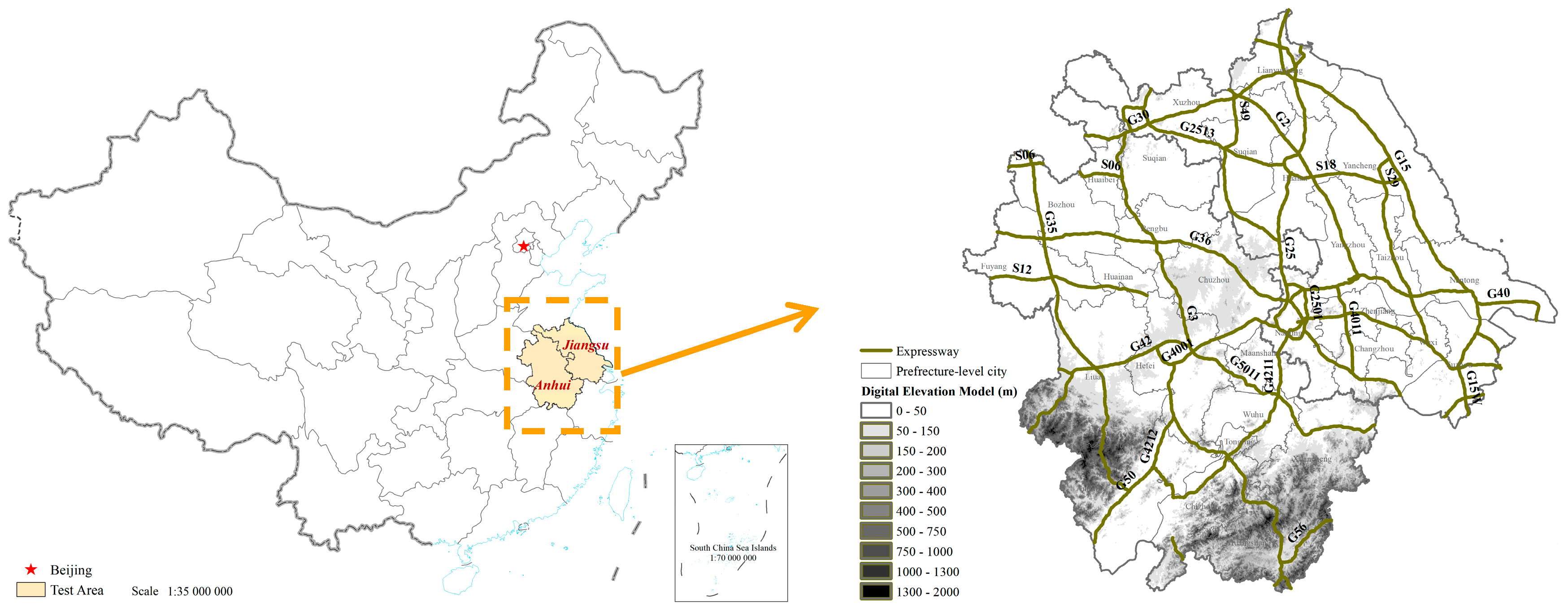
2. Data
3. Modeling Method
3.1. Index Selection
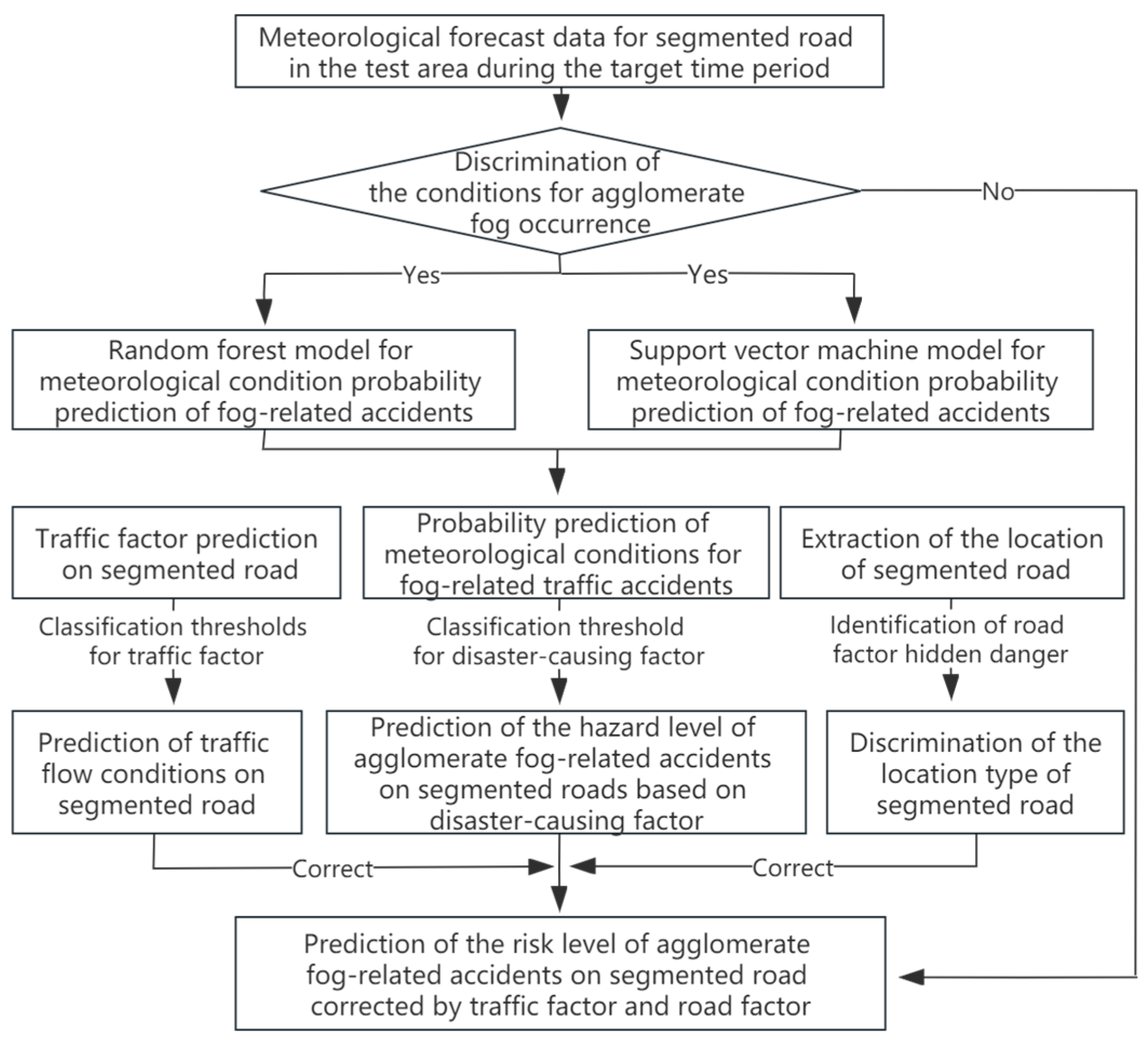
3.2. Assessment Procedure
4. Factor Values and Calculation
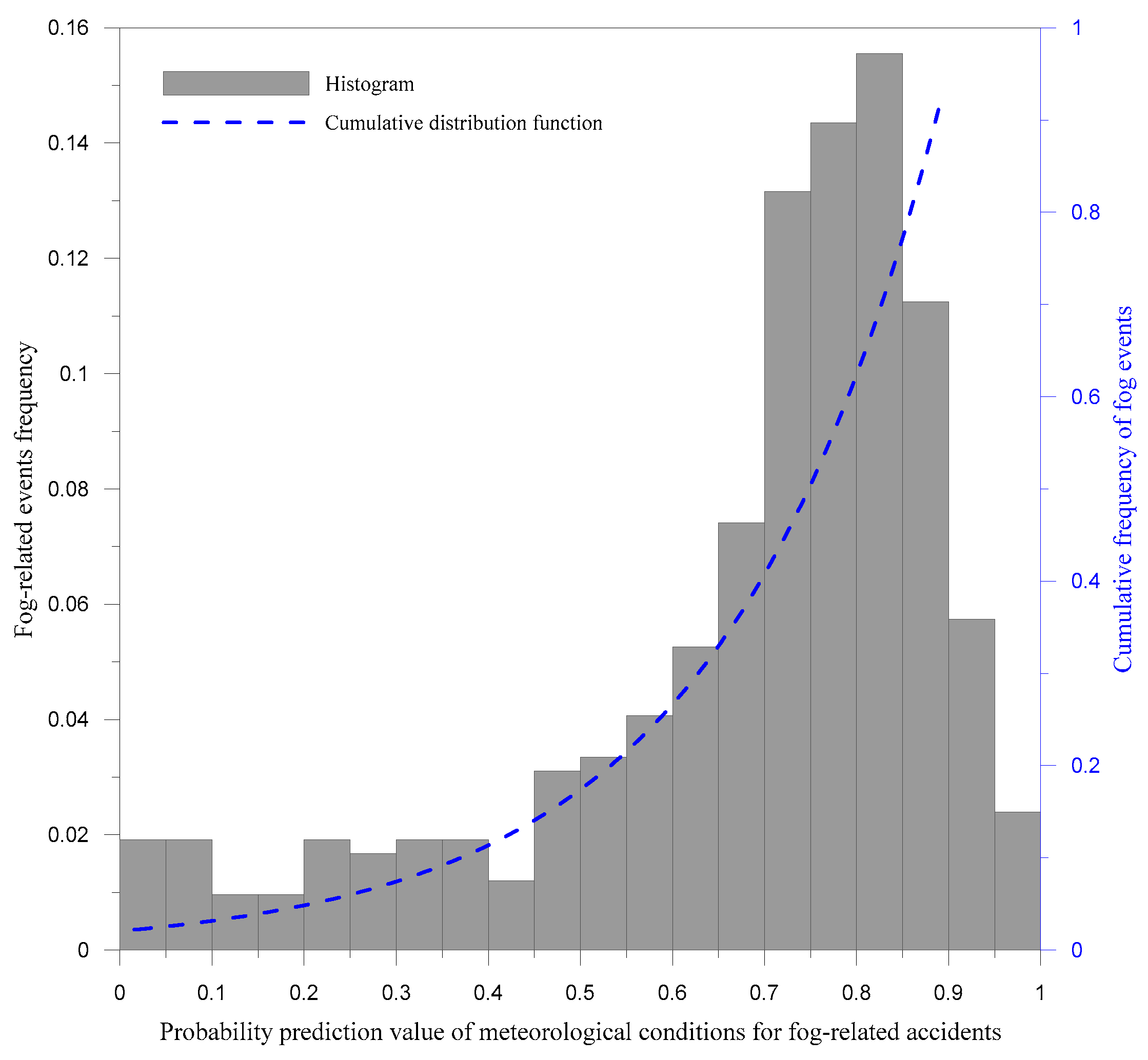
4.1. Classification of Disaster-Causing Factor
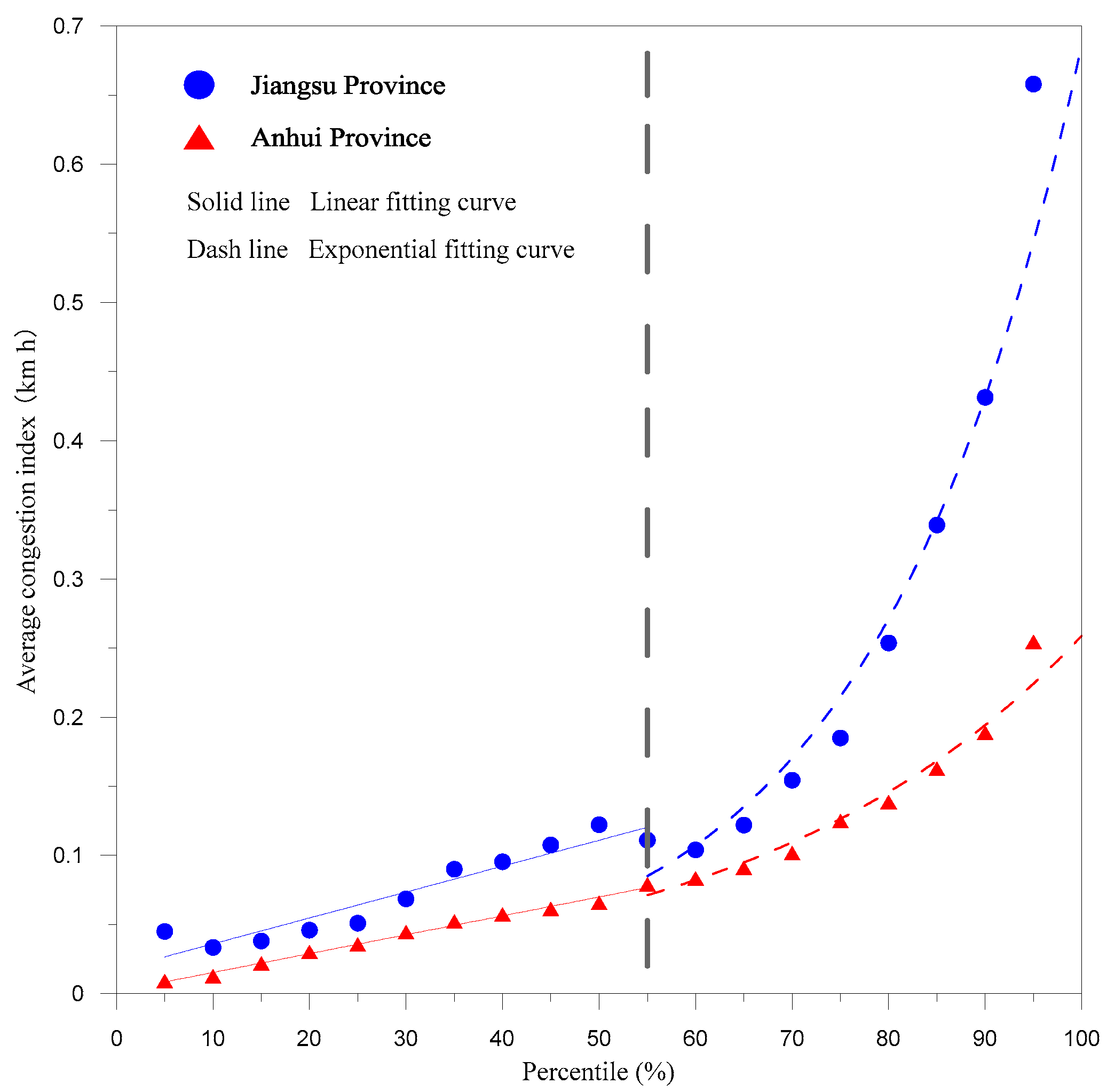
4.2. Classification of Traffic Factor
4.3. Identification of Road Factor Hidden Danger
5. Application and Validation
5.1. Overall Situation
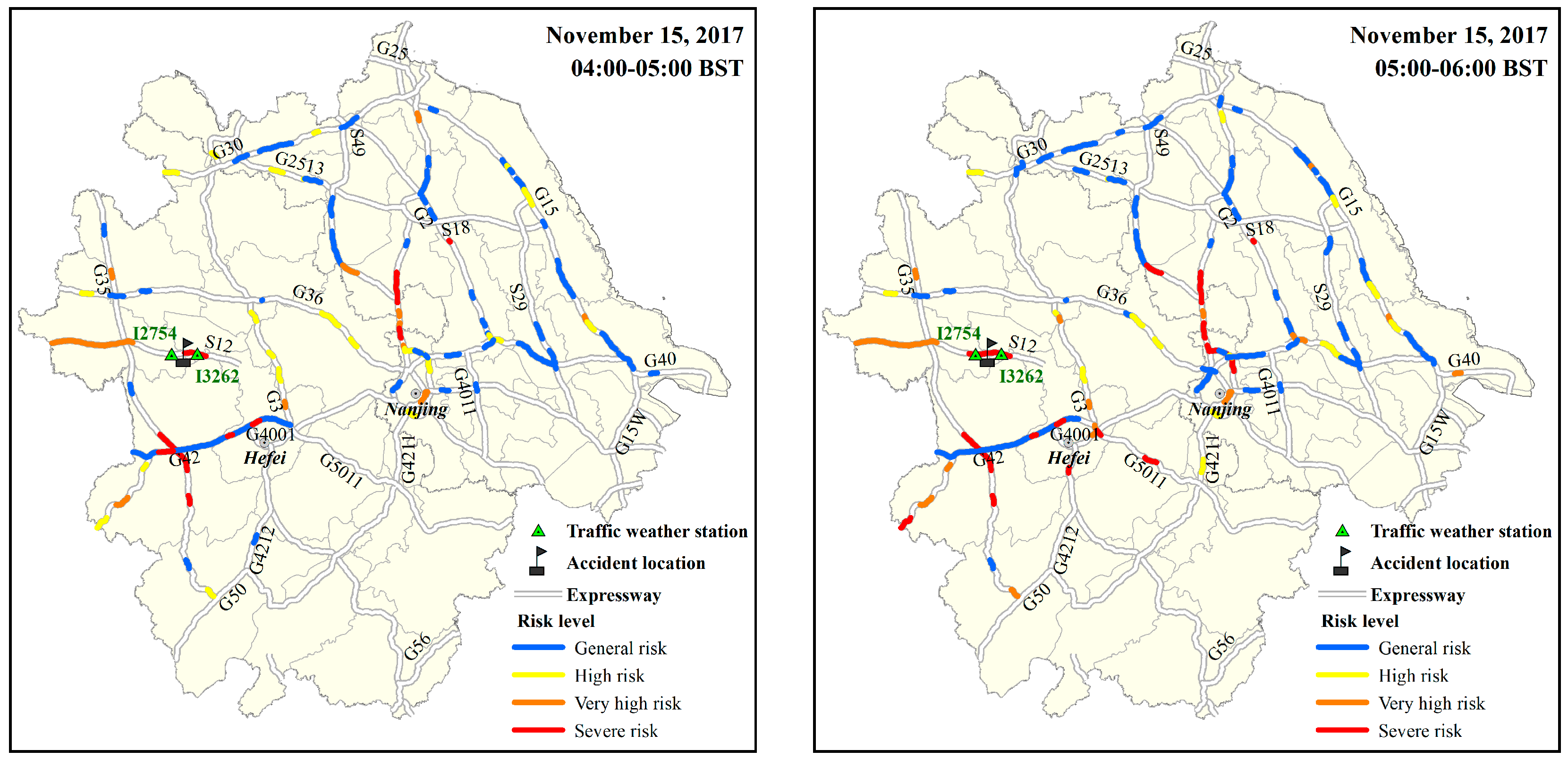
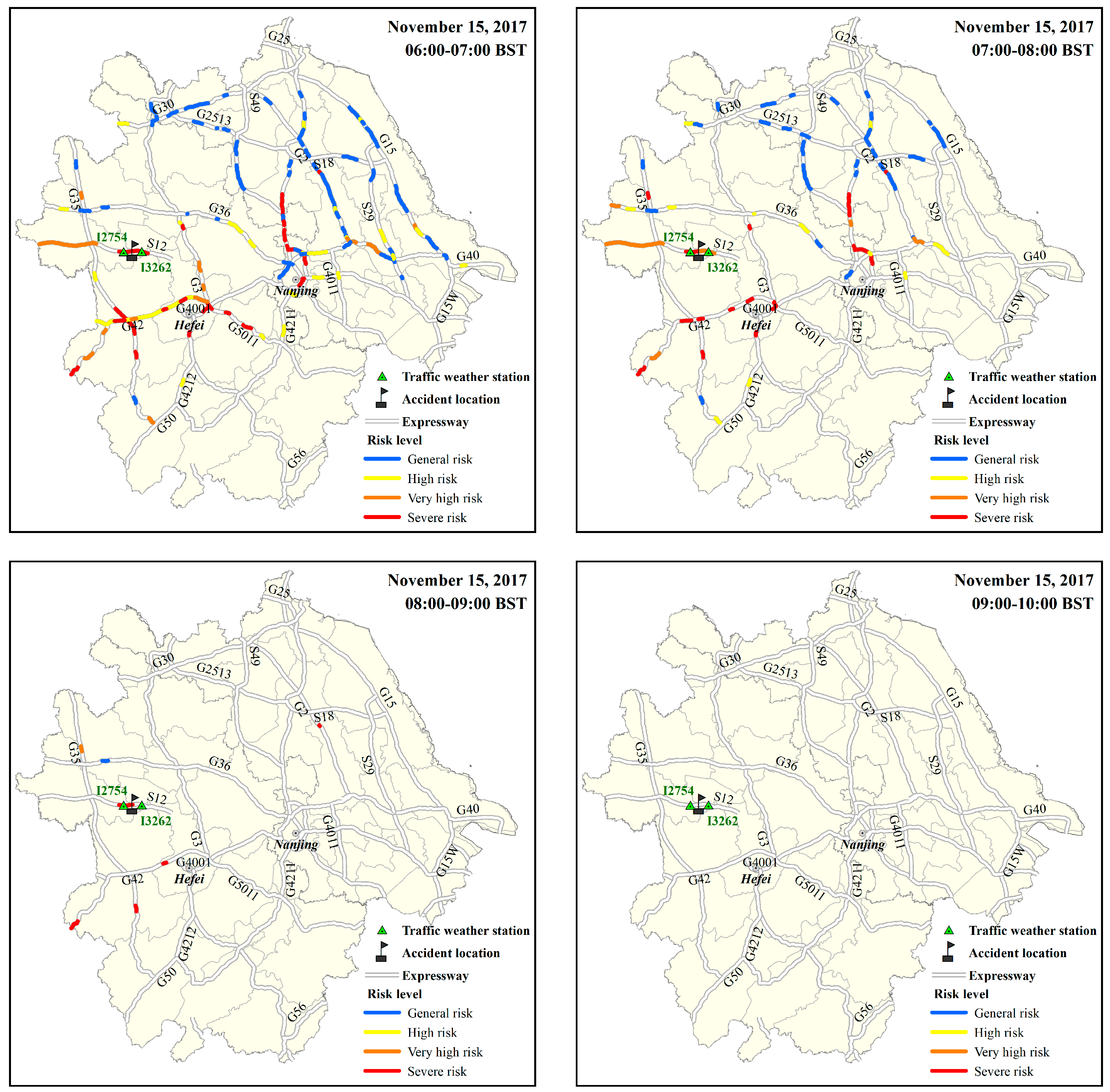
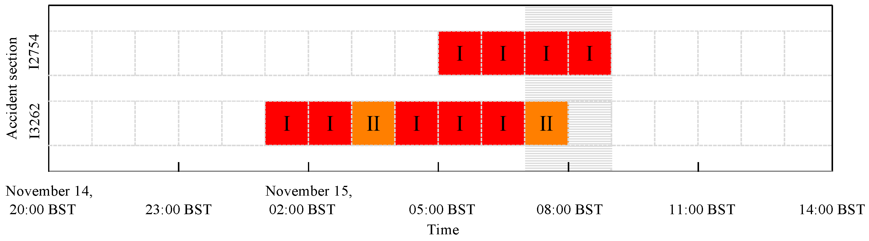
5.2. Typical Cases
6. Conclusions and Discussion
Author Contributions
Funding
Institutional Review Board Statement
Informed Consent Statement
Data Availability Statement
Conflicts of Interest
References
- Li, X.; Tang, B.; Zeng, C. Research and development of expressways in foggy area safety and security technology. J. Sci. Technol. Eng. 2018, 18, 196–206. [Google Scholar]
- Cornejo-Bueno, S.; Casillas-Pérez, D.; Cornejo-Bueno, L.; Chidean, M.I.; Caamaño, A.J.; Cerro-Prada, E.; Casanova-Mateo, C.; Salcedo-Sanz, S. Statistical analysis and machine learning prediction of fog-caused low-visibility events at A-8 motor-road in Spain. Atmosphere 2021, 12, 679. [Google Scholar] [CrossRef]
- Wang, B.; Xu, F.; Tian, X.; Yuan, C. A review of fog weather research methods in China in recent years. Meteorol. Sci. Technol. 2014, 42, 23–30. [Google Scholar]
- Jiang, Y.; Zhang, N.; Li, A.; Wu, H.; Li, R.; Yang, J. Effects of weather on highway traffic capacity in China: Characteristics and causes of roadblocks due to fog events. J. Pure Appl. Geophys. 2020, 177, 5027–5040. [Google Scholar] [CrossRef]
- Lu, C.; Liu, Y.; Niu, S.; Zhao, L.; Yu, H.; Cheng, M. Examination of microphysical relationships and corresponding microphysical processes in warm fogs. Acta Meteorol. Sin. 2013, 27, 832–848. [Google Scholar] [CrossRef]
- Mazoyer, M.; Burnet, F.; Denjean, C.; Roberts, G.; Haeffelin, M.; Dupont, J.; Elias, T. Experimental study of the aerosol impact on fog microphysics. Atmos. Chem. Phys. 2019, 19, 4323–4344. [Google Scholar] [CrossRef]
- Liu, Q.; Wu, B.; Wang, Z.; Hao, T. Fog droplet size distribution and the interaction between fog droplets and fine particles during dense fog in Tianjin, China. Atmosphere 2020, 11, 258. [Google Scholar] [CrossRef]
- Wang, Y.; Niu, S.; Lu, C.; Lv, J.; Zhang, J.; Zhang, H.; Zhang, S.; Shao, N.; Sun, W.; Jin, Y.; et al. Observational study of the physical and chemical characteristics of the winter radiation fog in the tropical rainforest in Xishuangbanna, China. Sci. China Earth Sci. 2021, 64, 1982–1995. [Google Scholar] [CrossRef]
- Weston, M.; Francis, D.; Nelli, N.; Fonseca, R.; Temimi, M.; Addad, Y. The first characterization of fog microphysics in the United Arab Emirates, an arid region on the Arabian Peninsula. Earth Space Sci. 2022, 9, e2021EA002032. [Google Scholar] [CrossRef]
- Wang, Y.; Lu, C.; Niu, S.; Lv, J.; Jia, X.; Xu, X.; Xue, Y.; Zhu, L.; Yan, S. Diverse dispersion effects and parameterization of relative dispersion in urban fog in eastern China. J. Geophys. Res. Atmos. 2023, 128, e2022JD037514. [Google Scholar] [CrossRef]
- Haeffelin, M.; Bergot, T.; Elias, T.; Tardif, R.; Carrer, D.; Chazette, P.; Colomb, M.; Drobinski, P.; Dupont, E.; Dupont, J.; et al. Parisfog: Shedding new light on fog physical processes. Bull. Am. Meteorol. Soc. 2010, 91, 767–783. [Google Scholar] [CrossRef]
- Guo, L.; Guo, X.; Fang, C.; Zhu, S. Observation analysis on characteristics of formation, evolution and transition of a long-lasting severe fog and haze episode in North China. Sci. China Earth Sci. 2015, 58, 329–344. [Google Scholar] [CrossRef]
- Duplessis, P.; Bhatia, S.; Hartery, S.; Wheeler, M.J.; Chang, R.Y.-W. Microphysics of aerosol, fog and droplet residuals on the Canadian Atlantic coast. Atmos. Res. 2021, 264, 105859. [Google Scholar] [CrossRef]
- Gultepe, I.; Tardif, R.; Michaelides, S.C.; Cermak, J.; Bott, A.; Bendix, J.; Müller, M.D.; Pagowski, M.; Hansen, B.; Ellrod, G.; et al. Fog research: A review of past achievements and future perspectives. Pure Appl. Geophys. 2007, 164, 1121–1159. [Google Scholar] [CrossRef]
- Pu, M.; Zhang, G.; Yan, W.; Li, Z. Features of a rare advection-radiation fog event. Sci. China Ser. D Earth Sci. 2008, 51, 1044–1052. [Google Scholar] [CrossRef]
- Penov, N.; Stoycheva, A.; Guerova, G. Fog in Sofia 2010–2019: Objective circulation classification and fog indices. Atmosphere 2023, 14, 773. [Google Scholar] [CrossRef]
- Snæbjörnsson, J.T.; Baker, C.J.; Sigbjörnsson, R. Probabilistic assessment of road vehicle safety in windy environments. J. Wind. Eng. Ind. Aerodyn. 2007, 95, 1445–1462. [Google Scholar] [CrossRef]
- Abdel-Aty, A.M.; Hassan, H.M.; Ahmed, M.; Al-Ghamdi, S.A. Real-time prediction of visibility related crashes. Transp. Res. Part C Emerg. Technol. 2012, 24, 288–298. [Google Scholar] [CrossRef]
- Ahmed, M.; Abdel-Aty, A.M.; Yu, R. Assessment of interaction of crash occurrence, mountainous freeway geometry, real-time weather, and traffic data. Transp. Res. Rec. 2012, 2280, 51–59. [Google Scholar] [CrossRef]
- Yuan, J.; Abdel-Aty, A.M.; Wang, L.; Lee, J.; Wang, X.; Yu, R. Real-time crash risk analysis of urban arterials incorporating bluetooth, weather, and adaptive signal control data. In Proceedings of the Transportation Research Board 97th Annual Meeting, Washington, DC, USA, 7–11 January 2018. [Google Scholar]
- Xu, C.; Wang, C.; Liu, P. Evaluating the combined effects of weather and real-time traffic conditions on freeway crash risks. Weather Clim. Soc. 2018, 10, 837–850. [Google Scholar] [CrossRef]
- Wu, Y.; Abdel-Aty, A.M.; Cai, Q.; Lee, J.; Park, J. Developing an algorithm to assess the rear-end collision risk under fog conditions using real-time data. Transp. Res. Part C Emerg. Technol. 2018, 87, 11–25. [Google Scholar] [CrossRef]
- Zhang, W.; He, Y.; Liu, H. Traffic Safety Enhancement Technique of Expressways in Fog Areas; China Communications Press: Beijing, China, 2008. [Google Scholar]
- Tian, X.; Wu, J.; Yan, M.; Yuan, C.; Jiao, S. Some new developments of the heavy fogs’ observation and forecast on the expressway. J. Meteor. Sci. 2009, 29, 414–420. [Google Scholar]
- Zhao, H.; Wang, W.; Li, Z.; Wang, Y. Effects of fog on traffic and transportation and the counterm easures in China. J. Meteor. Environ. 2010, 26, 58–62. [Google Scholar]
- Wang, L. Study on Speed Limit of Freeway in Foggy Day Based on Traffic Flow Condition and 85%th Speed. Master’s Thesis, Beijing Jiaotong University, Beijing, China, 2015. [Google Scholar]
- Zhang, Y.; Wang, Y.; Zhu, Y.; Yang, L.; Ge, L.; Luo, C. Visibility prediction based on machine learning algorithms. Atmosphere 2022, 13, 1125. [Google Scholar] [CrossRef]
- Song, J.; Wang, Z.; Li, A.; Tian, H.; Gao, J.; Wang, Y. Research on meteorological risk model for traffic safety on highway under foggy weather condition. J. Nat. Disaster. 2022, 31, 60–68. [Google Scholar]
- Song, J.; Tian, H.; Gao, J.; Wang, Z.; Li, A.; Chen, Y. An hourly meteorological model for fog accident discriminant based on machine learning technology. J. Meteor. Sci. Technol. 2023, 51, 149–156. [Google Scholar]
- Zang, C.; Peng, H.; Zhang, S.; Lyu, C. Real-time traffic safety evaluation method for freeway in fog. China Saf. Sci. J. 2017, 27, 110–115. [Google Scholar]
- Qu, X.; Zhang, D.; Guo, R.; Qi, Y.; Zhao, Z.; Wu, D. Forecasting method on integrated risk level of traffic condition based on weather conditions for highway of Hebei Province. J. Arid Meteorol. 2019, 37, 345–350. [Google Scholar]
- Tian, H.; Wu, X.; Cai, G.; Song, J.; Kong, C.; Feng, L. Weather Risk Warning and Countermeasures for Traffic Control; China Meteorological Press: Beijing, China, 2019. [Google Scholar]
- Guo, P. Research on the Early Warning and Safety Assurance Technology of Expressways Air-Mass Fog. Master’s Thesis, Chang’an University, Xi’an, China, 2016. [Google Scholar]
- Lestringant, R.; Bergot, T. Analysis of small-scale spatial variability of fog at Paris-Charles de Gaulle airport. Atmosphere 2021, 12, 1406. [Google Scholar] [CrossRef]
- Tian, H.; Gao, J.; Li, A.; Wu, Y.; Zhu, C.; Zhao, L.; Zhang, H. Meteorological characteristics of local agglomerate fog on Jiangsu highway. Desert Oasis Meteorol. 2019, 13, 39–46. [Google Scholar]
- Gao, J.; Tian, H.; Li, A.; Song, J.; Zhu, X. Analysis of agglomerate fog meteorological characteristics in Anhui Province based on traffic accident data. Pure Appl. Geophys. 2022, 180, 313–333. [Google Scholar] [CrossRef]
- Wan, X.; Bao, Y.; Yan, M.; Yuan, C.; Qian, W. Simulation of the dumpling fog on the Nanjing-Shanghai Expressway based on different land-surface schemes. J. Meteor. Sci. 2010, 30, 487–494. [Google Scholar]
- Shi, D.; Li, C.; Shi, Y.; Zhang, Y. Study on the localization diagnosis of extra heavy fog on the background of the fog weather based on machine learning algorithms. J. Catastrophol. 2018, 33, 193–199. [Google Scholar]
- Pagowski, M.; Gultepe, I.; King, P. Analysis and modeling of an extremely dense fog event in southern Ontario. J. Appl. Meteorol. 2004, 43, 3–16. [Google Scholar] [CrossRef]
- Ding, Q.; Bao, Y.; Yuan, C.; Yan, M. Occurrence pattern and local characteristics of dumpling fog events on Shanghai = Nanjing expressway. J. Meteor. Sci. 2013, 33, 634–642. [Google Scholar]
- Cui, C.; Bao, Y.; Yuan, C.; Jiao, S.; Wang, L.; Xie, X. Study on temporal and spatial occurrence pattern of fog on the coastal expressway of Jiangsu province. J. Sci. Technol. Eng. 2015, 15, 6–20. [Google Scholar]
- Yamamoto, A. Climatology of the traffic accident in Japan on the expressway with dense fog and a case study. In Proceedings of the 11th International Road Weather Conference, Sapporo, Japan, 26–28 January 2002. [Google Scholar]
- Hu, S.; Zhu, Y. Study on the mechanism of impact of agglomerate fog weather on expressway traffic safety. J. J. China Foreign Highw. 2013, 2, 290–292. [Google Scholar]
- Li, X.; Tang, B.; Zeng, C. Transient analysis of the driving behavior in the dumpling fog sections of expressway based on catastrophe theory. China J. Highw. Transp. 2018, 31, 78–88. [Google Scholar]
- Lu, Z.; Yang, C.; Zheng, Z.; Cui, G.; An, Y.; Gu, F. Study on warning level of expressway dense fog. J. Meteor. Environ. Sci. 2022, 45, 103–111. [Google Scholar]
- Bao, G.; Zhou, D.; Zheng, L.; Dai, Q.; Ma, S.; Liu, W. A study of severe snowfall disaster risk zoning along highways in Qinghai Province. Desert Oasis Meteorol. 2019, 13, 109–116. [Google Scholar]


| Meteorological Characteristics of Agglomerate Fog | Jiangsu Province | Anhui Province |
|---|---|---|
| Background conditions | Fog weather background | Fog weather background |
| Relative humidity | >92% | >86% |
| Daily temperature decrease | >7 °C | >8 °C |
| Wind speed | <2 m s−1 | <1 m s−1 |
| Hazard Level of Disaster-Causing Factor | Ordinary Location | Special Location | ||
|---|---|---|---|---|
| Off-Peak | Peak | Off-Peak | Peak | |
| Extremely high (Level 5) | Ⅰ | Ⅰ | Ⅰ | Ⅰ |
| High (Level 4) | Ⅱ | Ⅰ | Ⅰ | Ⅰ |
| Medium (Level 3) | Ⅲ | Ⅱ | Ⅱ | Ⅱ |
| Low (Level 2) | Ⅳ | Ⅲ | Ⅲ | Ⅲ |
| Extremely low (Level 1) | No | Ⅳ | Ⅳ | Ⅳ |
| Hazard | Extremely Low | Low | Medium | High | Extremely High |
|---|---|---|---|---|---|
| [0, 0.19) | [0.19, 0.60) | [0.60, 0.75) | [0.75, 0.84) | [0.84, 1] | |
| Number of accidents | 2 | 11 | 14 | 12 | 8 |
| Number of non-accidents | 105 | 26 | 7 | 3 | 0 |
| Validation Scope | Pearson Correlation Coefficient between Parametric Index of Hourly Traffic Flow and Observed Data | Consistency of Traffic Factor Levels Classified Based on Parametric Index and Observed Data | |
|---|---|---|---|
| Consistent with Traffic Flow Conditions | Inconsistent with Traffic Flow Conditions | ||
| Jiangsu Province | 0.850 | 85.6% | 14.4% |
| Anhui Province | 0.867 | 87.0% | 13.0% |
| Test area | 0.860 | 86.2% | 13.8% |
| Number | Accident Occurrence Period | Location | Situation | Distance of Traffic Station from the Accident Location and Corresponding Average/Minimum Visibility | Agglomerate Fog Index | Hazard Factor | Traffic Factor | Road Factor | Risk Level | |
|---|---|---|---|---|---|---|---|---|---|---|
| 1 | 13 February 2021 | 07:00–08:00 BST | Tongling, Anhui, Shanghai–Chongqi-ng Expressway (G50) | 7 accidents of several vehicles scraping each other and rear-end collision | 1 km (I5814) 2666/1630 m | matches the conditions | Level 2 | Off-peak | Special | Ⅲ |
| 2 | 3 October 2019 | 06:00–07:00 BST | Bengbu, Anhui, Nanjing–Luoyang Expressway (G26) | 10 people dead and 7 injured in 4 accidents | 8 km (I2858) 3768/3432 m | matches the conditions | Level 2 | Peak | Ordinary | Ⅲ |
| 3 | 15 November 2017 | 07:00–08:00 BST | Fuyang, Anhui, Chuzhou–Xincai Expressway (S12) | 18 people dead and 21 injured in multi-point and multi-vehicle collisions | 1 km (I2754) 80/57 m 71/68 m | matches the conditions | Level 5 | Peak | Special | Ⅰ |
| 08:00–09:00 BST | matches the conditions | Level 5 | Peak | Special | ||||||
| 4 | 5 February 2017 | 08:00–09:00 BST | Huaibei, Anhui, Sixian–Xuchang Expressway (S06) | 16 vehicles damaged and 6 people injured | 3 km (I1358) 226/165 m | mismatch with the conditions | Level 5 | Peak | Special | No |
| 5 | 2 April 2016 | 12:00–13:00 BST | Changzhou, Jiangsu, Shanghai–Chengdu Expressway (G42) | 51 vehicles damaged, 3 people dead and 31 injured | 5 km (M9112) 1058/846 m | matches the conditions | Level 2 | Peak | Ordinary | Ⅲ |
| 6 | 7 December 2015 | 00:00–01:00 BST | Yancheng, Jiangsu, Shenyang–Haikou Expressway (G15) | 3 people dead and 3 injured in multi-vehicle collisions | 4 km (M9437) 87/75 m | matches the conditions | Level 5 | Peak | Ordinary | Ⅰ |
| 7 | 23 May 2015 | 06:00–07:00 BST | Lianyungang, Jiangsu, Shenyang–Haikou Expressway (G15) | 4 people dead and 8 injured in dozens of rear-end collisions | 3 km (M9433) 197/115 m | matches the conditions | Level 4 | Peak | Ordinary | Ⅰ |
Disclaimer/Publisher’s Note: The statements, opinions and data contained in all publications are solely those of the individual author(s) and contributor(s) and not of MDPI and/or the editor(s). MDPI and/or the editor(s) disclaim responsibility for any injury to people or property resulting from any ideas, methods, instructions or products referred to in the content. |
© 2023 by the authors. Licensee MDPI, Basel, Switzerland. This article is an open access article distributed under the terms and conditions of the Creative Commons Attribution (CC BY) license (https://creativecommons.org/licenses/by/4.0/).
Share and Cite
Song, J.; Tian, H.; Yuan, X.; Gao, J.; Yin, X.; Wang, Z.; Qian, M.; Zhang, H. Study on Risk Prediction Model of Expressway Agglomerate Fog-Related Accidents. Atmosphere 2023, 14, 960. https://doi.org/10.3390/atmos14060960
Song J, Tian H, Yuan X, Gao J, Yin X, Wang Z, Qian M, Zhang H. Study on Risk Prediction Model of Expressway Agglomerate Fog-Related Accidents. Atmosphere. 2023; 14(6):960. https://doi.org/10.3390/atmos14060960
Chicago/Turabian StyleSong, Jianyang, Hua Tian, Xiaoyu Yuan, Jingjing Gao, Xihui Yin, Zhi Wang, Meichao Qian, and Hengtong Zhang. 2023. "Study on Risk Prediction Model of Expressway Agglomerate Fog-Related Accidents" Atmosphere 14, no. 6: 960. https://doi.org/10.3390/atmos14060960
APA StyleSong, J., Tian, H., Yuan, X., Gao, J., Yin, X., Wang, Z., Qian, M., & Zhang, H. (2023). Study on Risk Prediction Model of Expressway Agglomerate Fog-Related Accidents. Atmosphere, 14(6), 960. https://doi.org/10.3390/atmos14060960