Abstract
This study on the warm-sector heavy rainfall event in Guangzhou on 7 May 2017, examined the effects and mechanisms of incorporating 30 m high-resolution land surface data into its numerical simulation. The updated 1km numerical model, integrating 30 m high-resolution land surface data, successfully captured the initiation, back-building, and organized development of warm-sector convections in Huadu and Zengcheng District. The analysis revealed that the high spatial resolution of the surface data led to a reduced urban area footprint (urban −6.31%), increased vegetation cover (forest 11.63%, croplands 1%), and enhanced surface runoff (water 2.77%) compared with a model’s default land cover (900 m). These changes mitigated the urban heat island (UHI) effect within the metropolitan area and decreased the surface sensible heat flux. This reduction contributed to a pronounced temperature gradient between Huadu Mountain and the urban area. Additionally, a stronger high-pressure recirculation and sea–land breezes facilitated the transport of warm and moist air from the sea inland, creating a humid corridor along the sea–land interface. The consistent influx of warm and moist air near the mountain front, where strong temperature gradients were present, forcibly triggered warm-sector convection, intensifying its organization. This study highlighted the critical role of high-resolution land surface data in the accurate numerical simulation of warm-sector heavy rainfall.
1. Introduction
Land cover (LC) is the physical material at the surface of the Earth, including grass, trees, bare ground, water, croplands, urban and built-up areas, etc., which can be derived by field surveys or analyses of remotely sensed imagery [1]. Just as most research shows that landscape processes are a vital part of the climate system [2], the role of LC in altering cumulus clouds and convective rainfall has also been well documented (e.g., [3,4]). In the regional model, the LC data tend to be treated as static data like terrain; however, without an update in time, it is quite different from the real LC state, which may result in significant deviations in the simulation of land surface and boundary layer processes and then affect the accuracy of the numerical prediction of the distribution, occurrence time, and rainfall amount of convective rainfall. Therefore, it is necessary to study the impact of LC on the surface-atmosphere circulations in the mesoscale simulation to improve regional modeling.
A large number of numerical sensitivity experiments have shown that the physical properties of different surface covers (such as roughness, radiation balance, heat balance, etc.) affect the simulation of cumulus and precipitation by changing the vertical fluxes of water, heat, momentum, turbulence, etc., in the near-surface atmosphere. Specifically, LC mainly affects water vapor through changes in runoff and vegetation (evapotranspiration), surface roughness (advection transport), and heat flux (convergence and divergence). Ref. [5] replaced natural vegetation in the Chaophraya watershed of Thailand with farmland or secondary forests, and the changes in its aerodynamic characteristics, soil moisture content, and vegetation types led to changes in surface water flux, including transpiration, interception loss, evaporation, and runoff; ref. [6] found that when precipitation has convective properties, the influence of forest area on precipitation process is relatively small. Under frontal conditions, forests have a significant impact on local precipitation through water vapor convergence. The impact of LC on heat has received the most attention from researchers, mainly manifested as changes in sensible heat flux and latent heat flux. Ref. [7] found that from vegetation cover to urban cover, the corresponding temperature increases from 0.5 to 5.0 °C. Refs. [8,9] demonstrated that a decrease in forest and farmland areas, as well as an increase in low-density urban areas, leads to an increase in ground sensible heat flux and a decrease in latent heat flux, resulting in a decrease in dew point, an increase in cloud base height, and a decrease in precipitation. LC also has an important impact on momentum flux; firstly, different roughness values lead to changes in ground wind speed, and secondly, uneven heat leads to changes in convergence and divergence. Ref. [10] pointed out that larger “urban and built-up areas” in the surface cover lead to more friction, higher roughness, and lower ground wind speeds. Ref. [11] simulated that land use changes in the Andes–Amazon transition zone in Peru can cause changes in surface convergence and divergence. The impact of LC on turbulence has also been involved. Ref. [12] found that when soil moisture in oases approaches saturation, the secondary circulation (SC)/turbulent organized structure (TOS) is strongest/weakest. As the soil moisture content in the oasis decreases, SC (TOS) will become weaker (stronger). The underlying surface of urbanization is one of the hot research topics in surface cover and is often associated with UHI effects. Ref. [13] pointed out that the decrease in urban surface latent heat flux leads to daytime urban warming, followed by more heat release at night, resulting in nighttime warming, and the increase is higher than in daytime. On the whole, as the key factor in the atmosphere boundary and land surface process, the accurate LC in the regional model is essential.
However, the updating of LC information in the regional model has not kept pace with the rapid LC changes caused by human activities in recent decades. Although most LC can basically display and represent large cities and other land types, the low data resolution leads to deviations between land use type classification and actual status, such as blurred classification of farmland and forests and even misclassification. Large cities often experience urbanization, which leads to higher daytime temperature simulations and strong UHI effects [14]. Ref. [15] pointed out that the classification accuracy of LC can have a significant impact on precipitation forecasting when it is below 80%, especially in areas with complex land surface forcing. Many sensitivity experiments have verified that there are significant differences in the simulation ability of several typical LC datasets (such as USGS, MODIS, GLC, etc.) in regional numerical models. Ref. [16] used three data sets to simulate a rainstorm case in the Pearl River Delta (PRD) region of China, and the results showed that the overlap rate between the simulation results and the actual precipitation of GLC2000 (2000~−30 m), USGS (1993–1 km), and MODIS (2001~2010–900 m) data was 36.3%, 17%, and 24.9%, respectively. Accordingly, in order to improve the accuracy of the modeling of convective, microphysical, and meteorological elements in the boundary layer, the high-resolution LC is acquired.
Considering that studies of the influence of high-resolution LC on torrential rain are still rare, we develop the previous research in this paper to explore how high-resolution LC impacts convective rainfall. Ref. [17] applied new high-resolution satellite LC data to conduct a 1km simulation in the Sydney Basin of Australia, assessing the impact of LC changes on simulated storm events. The results indicate that satellite LC data can induce convective storms in urban centers, whereas model land surfaces cannot. The storms are highly sensitive to the presence of agricultural land in the southwest region of the area. The previous study did not investigate the relationship between LC and the trigger factor of convective rainfall despite proving that different LC can affect rainfall prediction. Therefore, we will make a thorough inquiry into the effects of high-resolution LC on the initiation and maintenance of convective rainfall and attempt to reveal the effect mechanism using the Weather Research and Forecasting (WRF) regional model modeling a warm-sector torrential rainfall event (WSTR) over the PRD region in China. The PRD has complex human and physical geography and large city agglomeration where the local disastrous heavy rains are easily triggered. The WSTR set a new record for the highest daily rainfall in history, leading to widespread flooding. Studies pointed out that the urban heat island effect was one of the WSTR convective trigger mechanisms [18,19]. The important point is that refined urban information in the LC dataset is significant because the urban has a large effect on convective rainfall as a special LC property. We will explore the possible influences of the high-resolution LC on convective rainfall in a 3D perspective in our study and try to provide references to the prediction of such kind of WSTR.
This paper is organized as follows: In Section 2, we present the synoptic conditions and development process of the precipitation event. In Section 3, we present the model description and experimental setup, as well as a description of the GlobeLand30 land use and MODIS LC datasets. In Section 4, we present and discuss the resulting differences between the two simulations for different LC. In Section 5, we analyzed the impact mechanism of LC on convective precipitation, and the conclusions and outlook are given in Section 6.
2. Case Description and Synoptic Background
A torrential rain event occurred at 1600 UTC on 6 May 2017 (0000 LST 7, local standard time LST = UTC + 8 h) and lasted for 16 h over Guangzhou City. This event broke the record for 3 and 12 h of rainfall with accumulated amounts of 382 and 544.5 mm, with characteristics of being local, having a long duration, strong hourly rainfall intensity, and a slow-moving mesoscale cloud. According to the shifting and the pattern of mesoscale clouds, this event developed in two stages. In the first stage, convective precipitation burst and then rapidly enhanced over the Huadu District of Guangzhou City. Due to the cluster convective clouds’ slow movement, the heavy precipitation accumulated was 287.9 mm from 1600 to 2100 UTC on 6 May near Huashan, with a maximum hourly rainfall amount of 120 mm. The cluster convective clouds moved to Zengcheng, and rainfall amounts of 184.7 and 150 mm occurred near Zengchneg and Xintang, respectively, for 5 h from 2100 UTC 6 on May to 0100 UTC on 7 May. In the second stage, beginning at 0100 UTC on 7 May, the banding convective clouds developed rapidly over Panyu and Dongguan District, which evolved from the cluster mesoscale clouds, and decayed at 0800 UTC on 7 May. The continually heavy rainfall caused floods, leading to urban waterlogging and building collapses. There were more than 20,000 flood victims, and the economic losses were up to CNY 177 million.
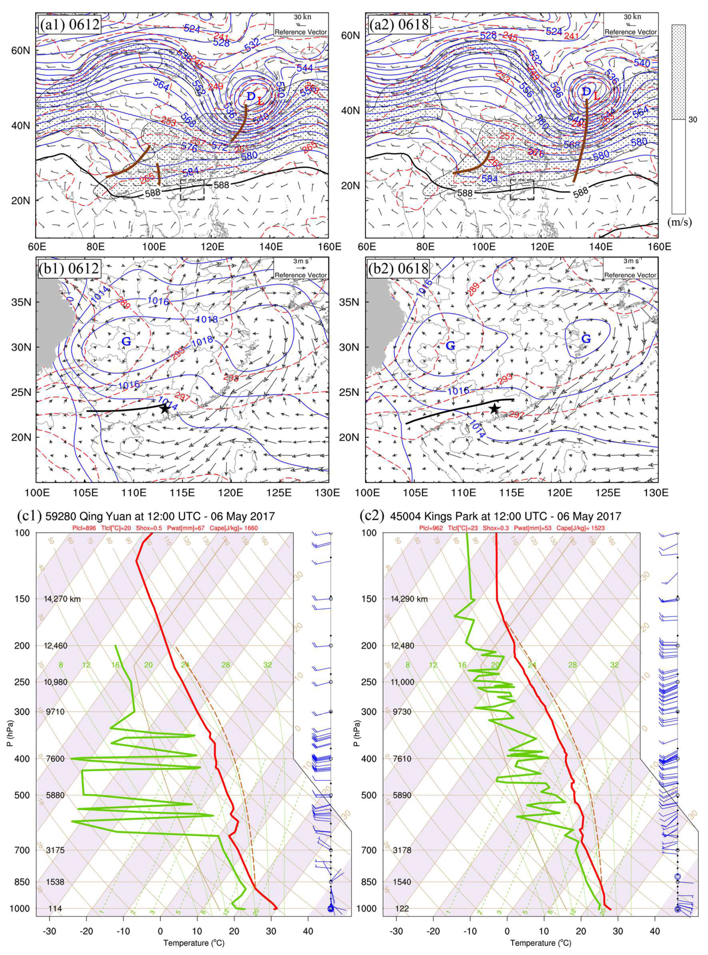
Based on the Global Forecast System reanalysis data from the National Centers for Environmental Prediction (NCEP), this event took place over a weak-gradient environment with little quasigeostrophic force. In the upper troposphere, the atmospheric circulation spread as ‘two trough one ridge’ in the middle and high latitudes of the Northern Hemisphere. The northwestern Pacific Ocean subtropical high is located over the tropical area, and mainland China is dominated by the westerly flow(Figure 1(a1,a2)). In the lower troposphere, a cold high is located over the Changjiang–Huaihe region of China, and a surface warm shear line is located from the west of Guangxi to the middle of Guangdong. As the Changjiang–Huaihe cold high moved to the East China Sea and the surface shear line moved east, an anticyclonic circulation with east-to-southeasterly flows formed in Figure 1(b1,b2). The air convergence, formed near the cold high ridge in the inverted trough and warm sector, transported warm, moist air and energy to the region of the rainfall.
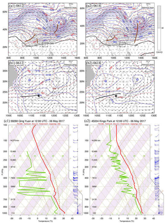
Figure 1.
(a1,a2) Geopotential height (blue solid contours, dagpm), the western Pacific subtropical high (black contours, dagpm), temperature field (red dash contours, K), wind field (wind barbs, m s−1), trough line (brown solid line) at 500 hPa, and high-level jet at 200 hPa (dotted, m s−1); (b1,b2) sea level pressure (blue solid contours, hPa), surface temperature field (red dashed contours, K), 10 m wind (arrows, m s−1), surface shear line (black solid line); (c1)vertical profiles plotted on skew T-lgp diagram of the state curve (red dashed line), stratification curve (red solid line), dew point curve (green line), and wind field (blue wind barbs) at Qing Yuan sounding station (ID59280) in Guangdong Province and (c2) same as (c1) but for King’s Park sounding station (ID45004) in Hong Kong at 1200 UTC, 6 May 2017. (a1,b1) 1200 UTC, 6 May 2017; (a2,b2) 1800 UTC, 6 May 2017. Blue letter “G” (“D”) and red letter “L” denote the centers of high (low)-pressure systems and warm (cold) air, respectively. The dashed black rectangle denotes the position of Guangdong Province. The black pentagram denotes the position of Guangzhou City.
The 1200 UTC, 6 May skew-T at Qing Yuan (Figure 1(c1)) and King’s Park (Figure 1(c2)) sounding stations show the development of unstable stratification in pre-precipitation with the convective available potential energy (CAPE) of 1660 and 1523 J·kg−1, negative lifted indices (LI), and large K-index and the small depression of the dew point. Although the conditional instability in the vicinity of Guangzhou was favorable for convective development, strong conditions were still needed to lift the condensation level for the rainstorm in the warm sector of South China. Therefore, the complex terrain of South China contributed exactly to it. The warm, moist airflow was carried by the anticyclonic circulation, derived from the South China Sea, to Guangzhou City, which is surrounded by trumpet-shaped mountains in the north through PRD and heated by Guangzhou’s UHI effects. The warmer, moist airflow was forced lifted by mountains and then met with the downhill cold, dry airflow, which triggered convections initially.
3. Model Description and Experimental Setup
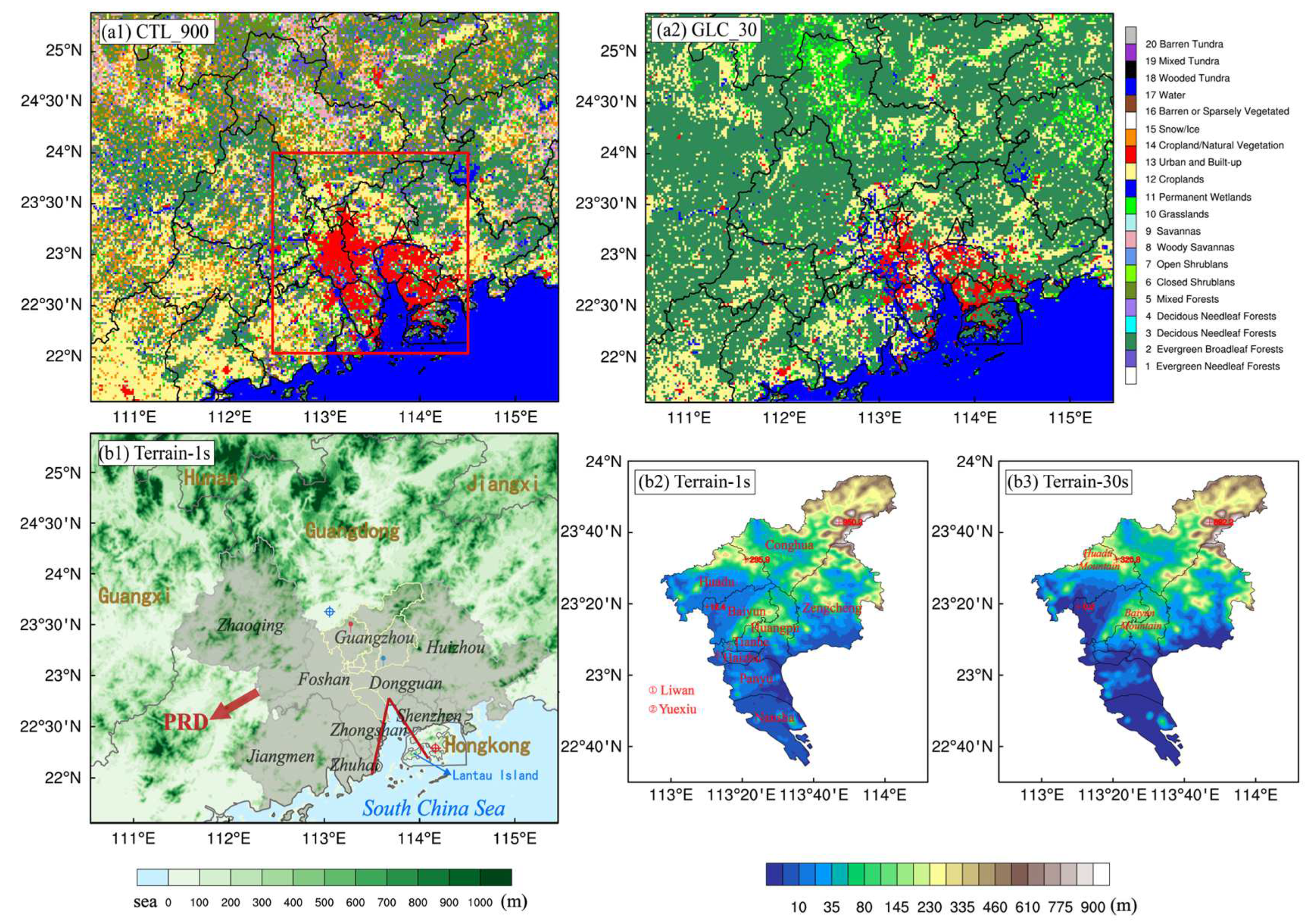
The Weather Research Forecast (WRF) model version 4.1 [11] is used in this study. WRF is a state-of-the-art atmospheric model designed for both research purposes and operational weather forecasting. The geographical position of the simulation domain is presented in Figure 2. It covers a large part of Guangdong Province. We run WRF on a horizontal resolution of 1 km × 1 km, with 81 vertical levels. The size of the integration domain is 533 grid points in both horizontal dimensions. Our model configuration includes the Morrison double-moment microphysics, the Yonsei University (YSU) planetary boundary layer scheme, and the Dudhia short- and long-wave radiation schemes. For these 1 km simulations, we activate the urban canopy model to catch the city’s physical properties over urban grid points. The Global Forecasting System reanalysis data, provided by the National Center for Environmental Prediction (NCEP), with 0.5° × 0.5° and 6 h of time and spatial resolution, are applied to initialize the model.
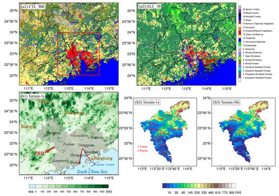
Figure 2.
The illustration of numerical simulation area. (a) Static Land Use Index in 1 km WRF model (a1) for CTL_900 and (a2) for GLC_30. The pentagram denotes Huadu, and the triangle denotes Zengcheng. (b1) Static terrain height in 1 km WRF model for 30 m topography. The blue plus sign within a circle denotes Qing Yuan sounding station, and the red plus sign within a circle denotes King’s Park sounding station. Red location pin denotes Huashan automatic weather station, and blue denotes Xintang station. Gray-shaded area represents the Pearl River Delta (PRD). The shape formed by the two short rays represents bell-mouth topography in the PRD. (b2) The terrain height of Guangzhou based on (b2) 1 s (30 m) terrain data and (b3) 30 s (900 m).
The two simulations incorporate the GlobeLand30 dataset and the WRF default MODIS LC data for the Guangzhou 5·7 case, respectively. The simulations with MODIS 30-arc second LC are henceforth denoted as CTL_900, and the simulations with GlobeLand30 LC are denoted as GLC_30. Considering the rapid urbanization in China, the newest WRF default 30-arc second MODIS data (2001–2010) instead of the USGS 30-arc second LC (1993) is applied to reduce simulation bias [20]. The GlobeLand30 dataset, which has 10 LC categories, was created using 30 m multispectral satellite images, including Landsat series’ TM5, ETM+, OLI and China’s HJ-1, in 2010. It is often recognized as significant LC data with higher resolution and classification accuracy and latest urban information [21]. To make the GlobeLand30 LC compatible with WRF Pre-processing System (WPS), they are reclassified as the MODIS categories (20 land use categories, [22] (Table 1)) and re-projected to the World Geodetic Coordinate System 1984 (WGS84). Figure 2(a1–b2) show the differences between the GLC_30 and the CTL_900 LC, while the patterns of urban areas, croplands, forests, and water are very different because of different spatial resolutions and original classification standards. Obviously, the CTL_900 LC has overestimated urban areas and agricultural lands. It only has one kind of forest category, which is why the GlobeLand30 looks very green. To keep the topography consistent with the LC in WRF model, we also introduced the 30 m high-resolution topography dataset (Figure 2(b1)) in both of the two experiments. We used the 30 m high-resolution topography to increase the sensitivity of WRF model to surface heterogeneity of domain area, especially trumpet-shaped mountain areas in PRD. It is one of key factors to simulate the convective initiation well.

Table 1.
Reclassification schemes for GlobeLand30 LC in MODIS categories.
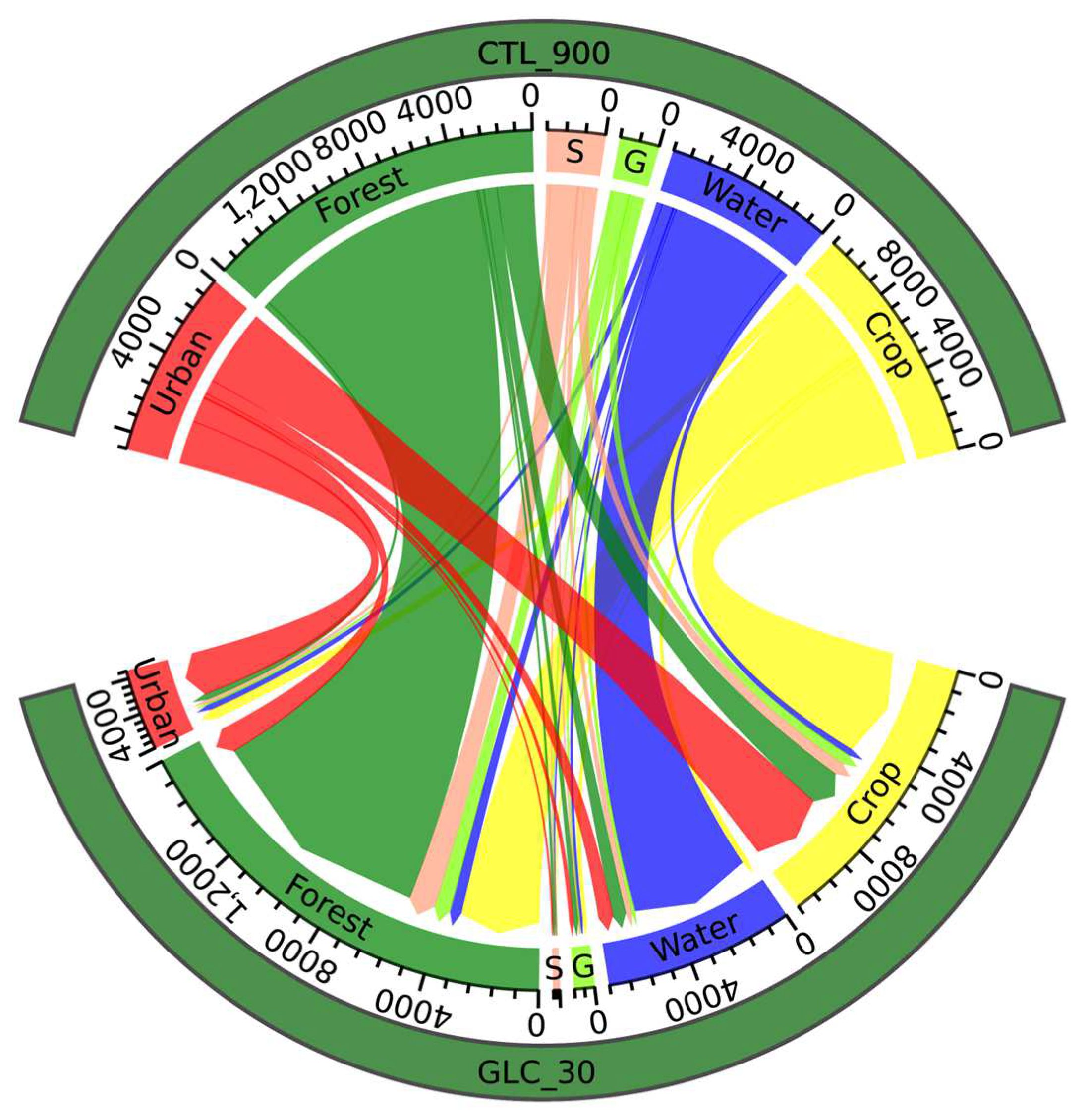
Figure 3 and Table 2 show that the introduction of GLC_30 significantly reduces the urban area in the model and increases green space and surface runoff, leading to significant changes in surface roughness and albedo, thereby affecting the latent heat flux and sensible heat flux in the boundary layer. The increase in green space is mainly caused by the reduction of types such as farmland, grassland, and shrubs, while the transformation from cities to farmland represents the inaccurate recognition and classification of coarse resolution LULC.
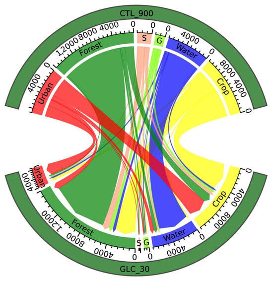
Figure 3.
Six main types of LULC transitions between CTL_900 and GLC_30 (in km2) within the red box area in Figure 2(a1,a2) (112.5 E–114.5 E, 22 N–24 N). S represents shrublands and savannas; G represents grasslands.

Table 2.
Statistics of different LC types from CTL_900 to GLC_30 within the red box area in Figure 2(a1,a2) (112.5 E–114.5 E, 22 N–24 N).
4. Simulation Results
4.1. Simulation Results of Surface Rainfall
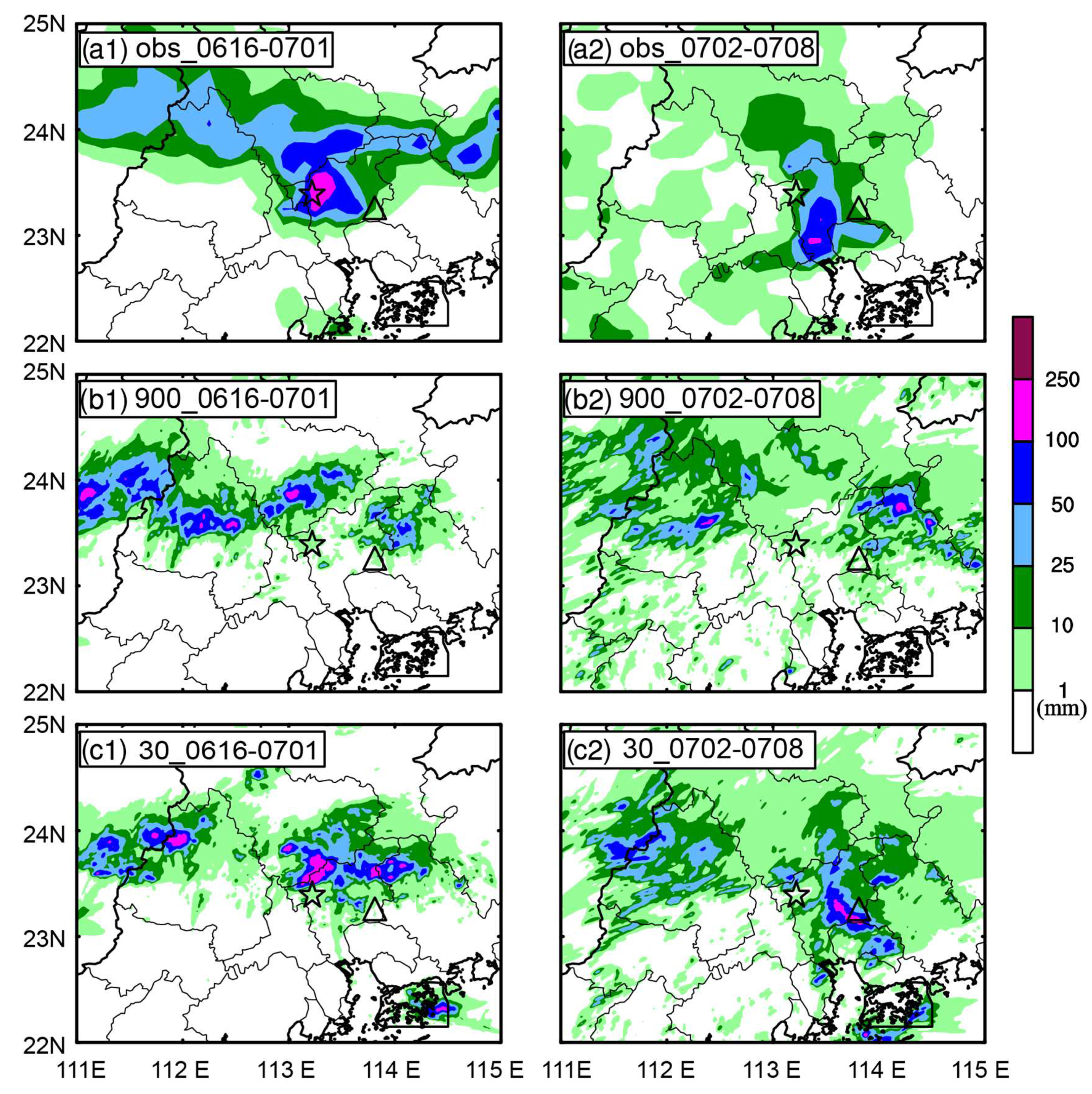
Figure 4 shows the simulated precipitation differences of the GLC_30 and CTL_900 tests compared with the observed precipitation, respectively. The simulated accumulated rainfall at the surface was verified with the observed precipitation, which was a merged product of automatic weather stations in China and CMORPH satellite data, with a temporal resolution of 1h and horizontal resolution of 0.1° × 0.1°. Obviously, the simulation tests simulated the two stages’ precipitation features well in spite of the rainfall, pattern, and distribution being very different. The GLC_30, with the 30 m high-resolution LC data, had forced a stronger cluster precipitation center with more than 100 mm accumulated rainfall in 9 h over the northerly of Huadu at stage 1 and banding precipitation center with more than 100 mm accumulated rainfall in 7 h spreading from north to south over the southeast of Zengcheng at stage 2; meanwhile, the precipitation with less than 100 mm accumulated rainfall in 9 h at stage1 was simulated as being weaker than observed. The CTL_900 has only simulated the light rain with the MODIS 30-arc second LC. It showed a bad performance in the simulation of heavy precipitation centers. Compared to GLC30, CTL_900 can only simulate the approximate location of precipitation, and the rainfall is far from reaching the level of observed precipitation. This indicates that CTL_900 can trigger convection near Huadu Mountain but cannot provide sufficient dynamic and thermal conditions for the development, maintenance, and organization of convection. It is worth mentioning that the observed data showed a little strong precipitation center over the west of Hong Kong Island. It has appeared in the GLC_30 simulation over Hong Kong Island but is stronger. The simulation precipitation results indicate the important impact of the 30 m high-resolution LC introduced into the cloud-resolution-scale WRF numerical model on the WSTR’s simulation.

Figure 4.
Observed and simulated accumulative precipitation (shaded, mm). The pentagram denotes Huadu, and the triangle denotes Zengcheng: (a1,a2) observed; (b1,b2) CTL_900; (c1,c2) GLC_30; (a1–c1) Stage 1: from 1600 UTC on 6 May to 0100 UTC on 7 May 2017; (a2–c2) Stage 2: from 0100 to 0800 UTC on 7 May.
4.2. Simulation Results of Radar Reflectivity
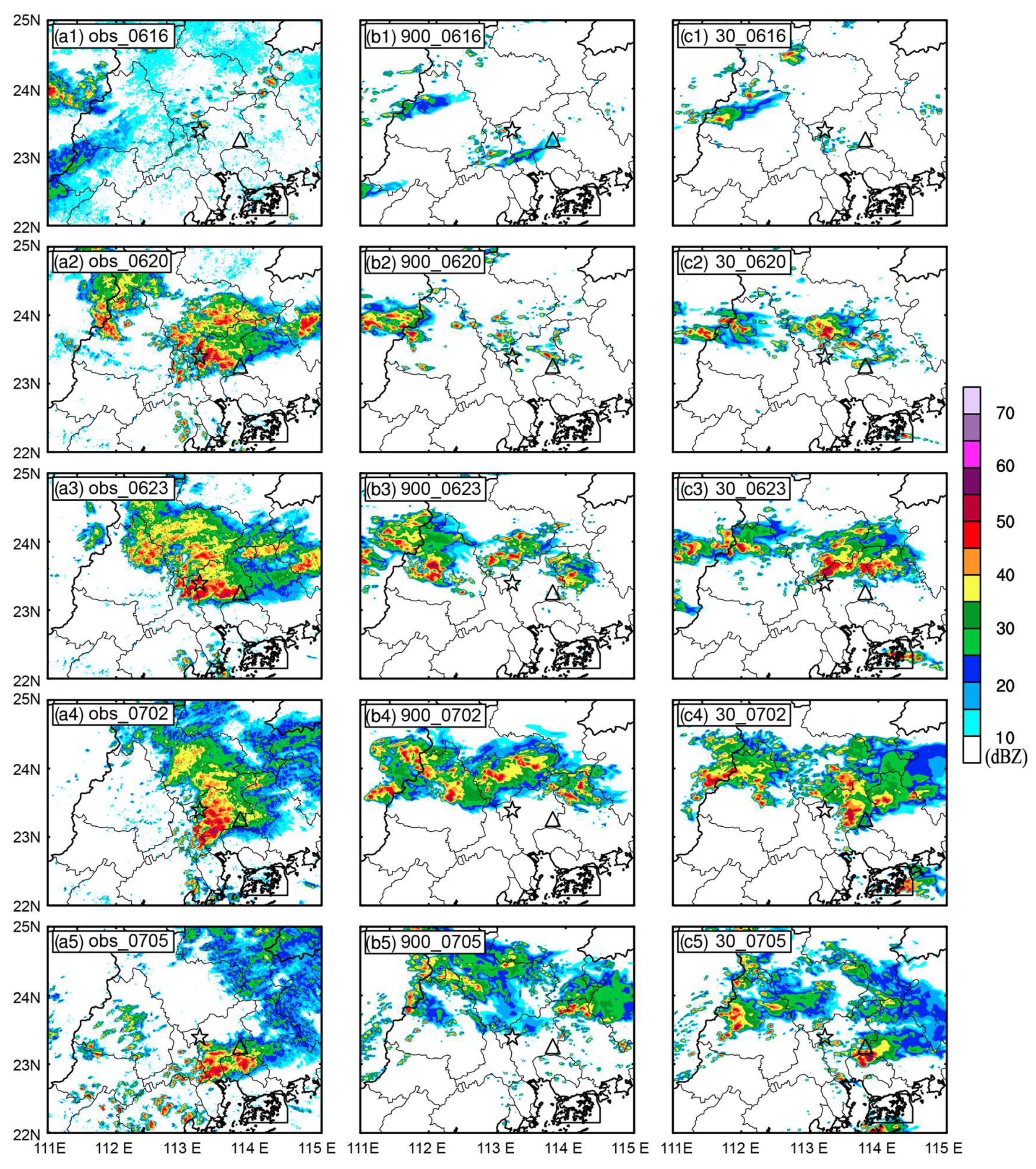
Figure 5 shows the observed and simulated radar reflectivity evolving over time. The observed data were the combined radar reflectivity from the China Meteorological Administration with a temporal resolution of 1 h and horizontal resolution of 1 km × 1 km. At 1600 UTC, the simulated convective triggered at Huadu, which signifies that the more significant temperature gradient formed between Huadu Mountain and UHI of Guangzhou city, which was simulated using the WRF model and introduced refined terrain and LC into facilitated the convection trigger. At 2000 UTC, compared with the CTL_900, the GLC_30 showed the high-resolution LC’s superiority, although weaker than observed. Then, at 2300 UTC, the main convective system matured. In the GLC_30 tests, the westerly convective system maintained stability rather than merging into the main convective system eastward. That is why the convective system of the GLC_30 is weaker than the CTL_30. But during subsequent promotion, including the Hong Kong Island convective, the main convective system’s pattern, direction, and arrangement of the GLC_30 were consistent with the observed.
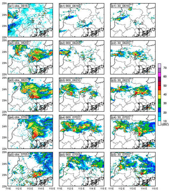
Figure 5.
Observed and simulated composite radar echo (shaded, dBZ); The pentagram denotes Huadu, and the triangle denotes Zengcheng: (a1–a5) Observed; (b1–b5) CTL_900; (c1–c5) GLC_30. (a1–c1) 1600 UTC; (a2–c2) 2000 UTC; (a3–c3) 2300 UTC on 6 May 2017; (a4–c4) 0200 UTC; (a5–c5) 0500 UTC 7 on May 2017.
Overall, the GLC_30 tests reappeared the cluster and banding convective clouds’ developments of the Guangzhou 5·7 torrential rainfall event in the warm sector, with obvious characteristics of backward propagation and train effects. It illustrates that the complex LC pattern of the underlying surface in South China has important influences on the derivation, dissemination, and organization process of the torrential rain in the warm sector. This just confirms the results of simulated precipitation.
5. Impact Mechanism Analysis
5.1. Surface Sensible Heat Flux and Latent Heat Flux
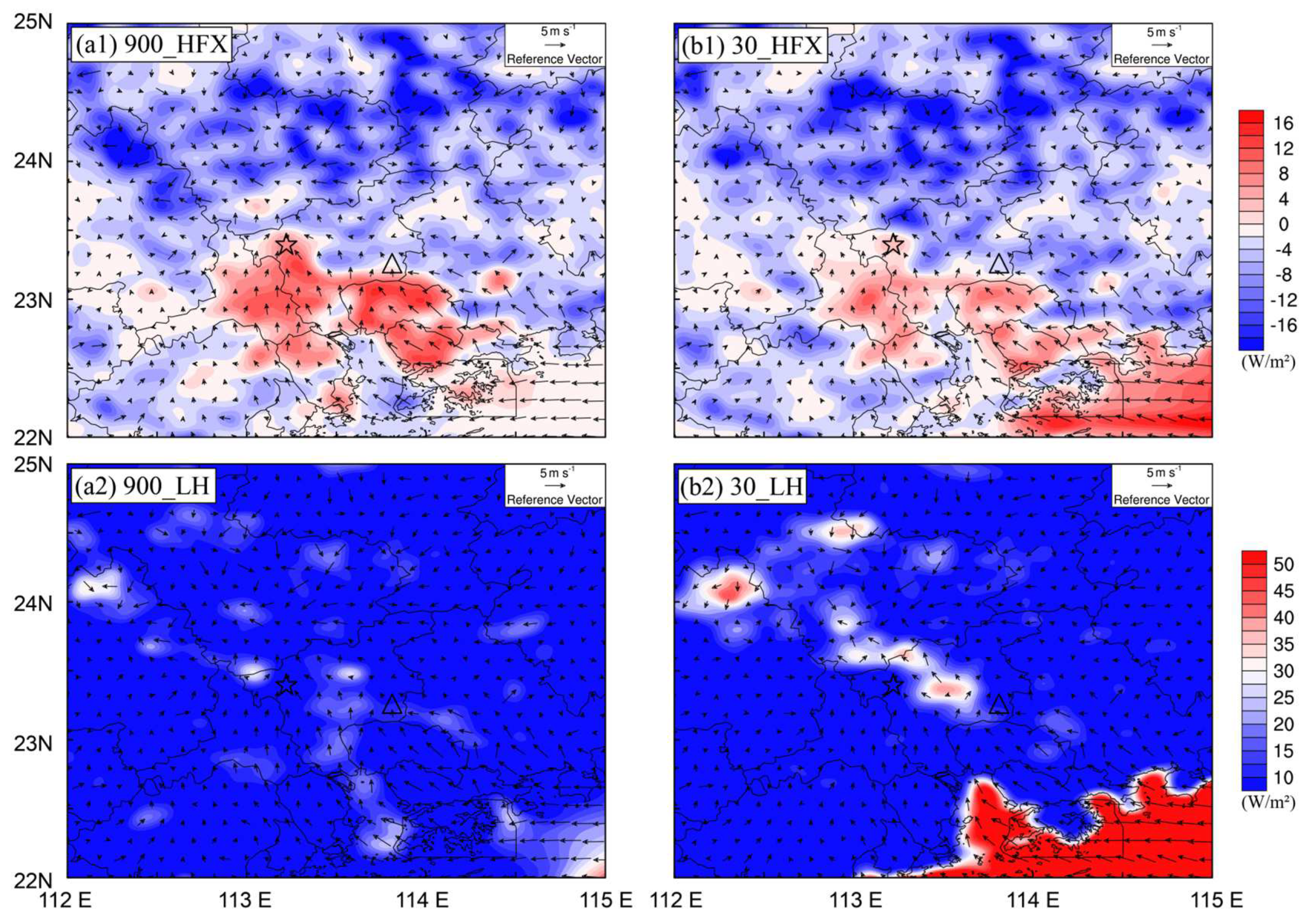
Figure 6 shows the significant differences in the process of convective triggering in numerical simulation, which are noted in sensible and latent heat fluxes and horizontal winds. At midnight, the UHI caused by the PRD urban agglomeration gave rise to the ground’s stronger sensible heat flux, even exceeding the temperature of the ocean. On the one hand, the underlying surface of the city contains a large number of artificial structures, such as asphalt roads, concrete, etc., whose thermal properties will change the heat exchange between the atmosphere and the ground, resulting in unstable atmospheric stratification. On the other hand, the water content of the urban surface decreases, and the surface evaporation and latent heat release are reduced. In addition, a large number of boilers, heaters, air conditioners, and other heating devices in the city, as well as man-made emissions from motor vehicles, make the temperature of the city much higher than the ambient temperature, forming a UHI [23]. Overestimation of urban areas will lead to a stronger UHI effect in the model. Therefore, in the high-resolution underlying surface data test GLC_30, the decrease in urban area close to the actual situation and the increase in green space and surface runoff make the UHI effect slightly slow down, and the sensible heat flux is weaker than the CTL_900 test. It is worth mentioning that after the introduction of high-resolution underlying surface data, the temperature gradient in the convection triggered area in Huadu has increased significantly. The strong temperature gradient zone formed by the descending cold air in the Huadu Mountain area in the north of Huadu and the warm and humid flow through the UHI of Huadu, is the reason for Huadu convection triggering.
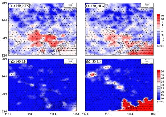
Figure 6.
(a1,b1) Sensible heat flux (HFX) (shaded, W/m2) and 10 m wind field (arrow, m·s−1) of the previous convective wind triggered at 1600 UTC on 6 May 2017. (a2,b2) Latent heat flux (LH) (shaded, W/m2) and 10 m wind field (arrow, m·s−1) of the previous convective wind triggered at 1600 UTC on 6 May 2017. The pentagram denotes Huadu, and the triangle denotes Zengcheng: (a1,a2) CTL_900; (b1,b2) GLC_30.
At the same time, the ground latent heat flux simulated by the CTL_900 test is weaker than that of the GLC_30 test. The strength of the surface latent heat flux represents the strength of the phase-change process of near-surface water vapor. In the GLC_30 test, the area around Huadu has a relatively high ground latent heat release, indicating that the Huadu convection has been triggered at this time, and the warm and humid airflow along the strong temperature gradient zone is forced to uplift by the local low mountain topography to reach the uplifting condensation height, phase-change condensation occurs, and latent heat is released. A certain amount of latent heat release will heat up the ambient air, leading to increased instability of stratification over Guangzhou, which is conducive to the deepening of convection. This is also the reason for the slow development and weaker strength of convection in the CTL_900 test.
The 10 m wind field indicates that the South China Sea anticyclonic circulation (high-pressure reflux) accelerates through the bell-mouth topography of the PRD region and transports the warm and humid air currents from the South China Sea to the inland. Comparing the two experiments, the return wind on the southern ocean surface of southern China was a northerly easterly wind in the CTL_900 test and strengthened the southerly easterly wind in the GLC_30 test. On the one hand, the strengthening of the return wind is due to the weakening of the continental sensible heat flux and the enhancement of the sea and land breeze; on the other hand, the triggering of the convection in the Huadu area increases the updraft and the ground convergence, which causes the wind speed in the water vapor source area to increase. At the same time, the heat input to the north from the warm tongue center of the southern ocean surface increased, which greatly increased the sensible heat flux on the southern ocean surface of South China.
The cloud-resolved numerical model of the introduction of high-resolution LC data to simulate the sensible heat flux, latent heat flux, and 10 m wind field of the “5·7” warm sector in Guangzhou shows that on the one hand, the accurate description of the underlying surface data is an important factor that affects the model simulation results, and on the other hand, the increase in the horizontal and vertical resolution of the model can make the underlying surface data influence the model boundary layer process with more detail and accuracy, which is closer to the actual situations. It’s beneficial for accurately expression of the land-atmosphere heat and water vapor exchange process influenced by the complex terrain and LC within model, thereby improves the simulation accuracy of warm sector heavy rainfall.
5.2. Generalized Potential Temperature and Dynamic Condition
The changes in the ground sensible heat flux and latent heat flux and the 10 m wind field caused by high-resolution LC data are mutually reinforcing and influence each other. The hot and humid air is continuously transported to the Huadu area through the southerly return flow to maintain the dynamic heat supply for the development of convection. The generalized potential temperature (GPT) can describe the temperature and humidity distribution of the real atmosphere [24], so this research uses the GPT to verify the formation of the warm and moist channel and the secondary circulation between the strong convective cloud cluster and the South China Sea.
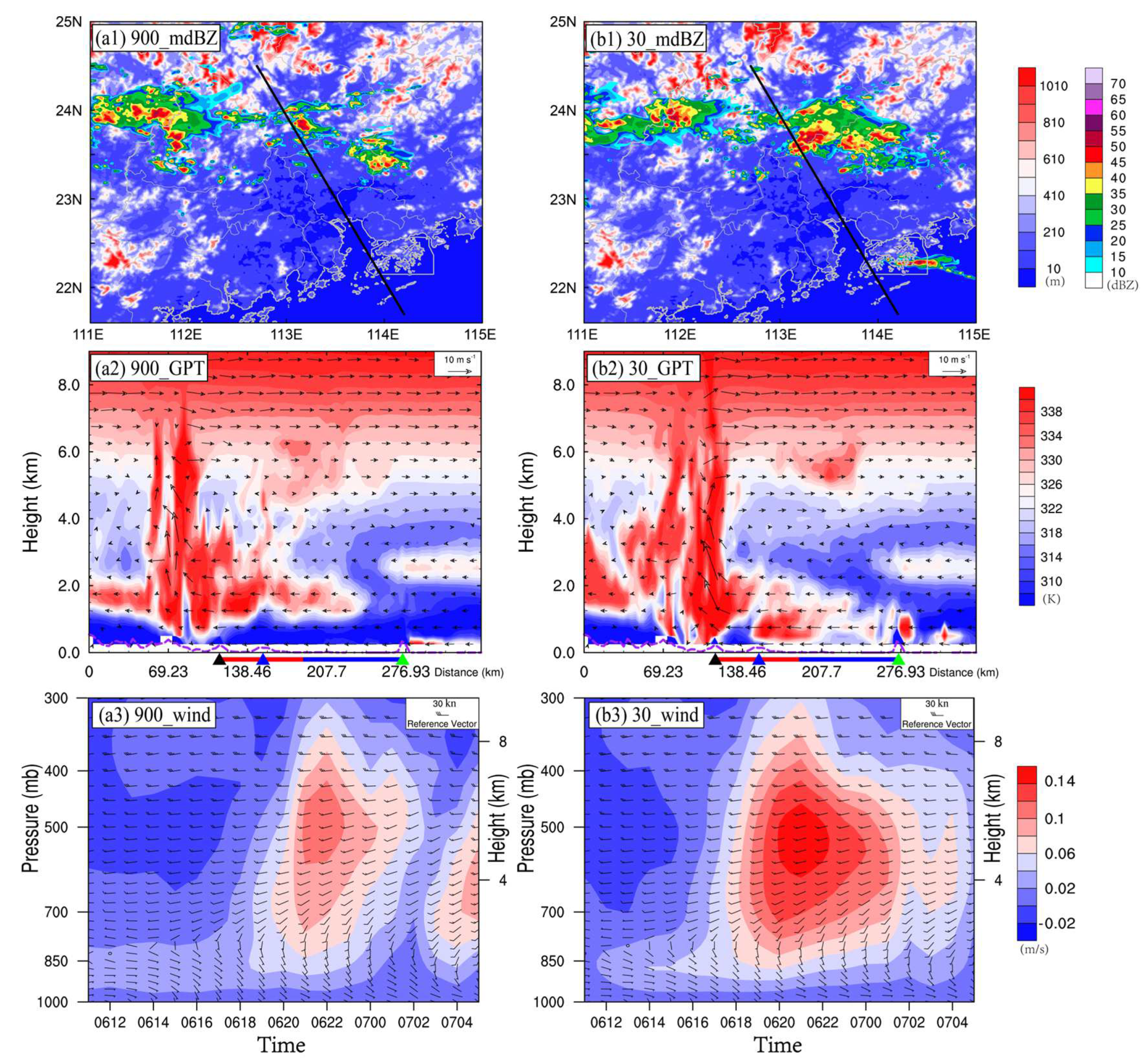
At 19:00 on 06 May, during the GLC_30 experiment, the convection in Huadu developed vigorously, new convective cells were constantly triggered on the right front, and the convective clouds began to develop southward. The big difference from the CTL_900 test is that in the GLC_30 test, a strong convective cloud belt was simulated in Hong Kong. Take a section along the black line in Figure 7(a1,b1) to obtain the GPT and vertical circulation field distribution. The vertical profile of the GPT shows that the lower level of the CTL_900 experiment is drier and colder, and the circulation wind field is weaker. The warm and wet areas of the South China Sea are blocked by the terrain of Hong Kong and cannot be transported to the mainland via the trumpet terrain. The lower level of the GLC_30 test is warmer and wetter, and the lower-level circulation wind field is stronger, which can lift the warm and humid airflow over the South China Sea to a sufficient height, cross the topography of Hong Kong, and form a strong warm and humid channel between the ocean and the inland, which is continuously directed. Huadu convection conveys dynamic thermal conditions. In addition, the outbreak of band convection in Hong Kong has increased the latent heat flux on the ocean surface (Figure 7(b2)), and the development of secondary circulation has become more vigorous, which is conducive to the backward development and organization of Huadu convection

Figure 7.
(a1,b1) radar echo (shaded, dBZ) and terrain (shaded, m) at 1900 UTC on 6 May 2017; (a2,b2) vertical profile of GPT (shaded, K) and horizontal wind (arrow, m·s−1) along the black line in (a1,b1). Black triangles indicate Huadu Mountain, blue triangles indicate Baiyun Mountain, and green triangles indicate Lantau Island. Red lines show the city area, and blue lines show water area; (a3,b3) regional average of vertical velocity (shaded, m/s) and horizontal wind field (vector): (a1–a3) CTL_900; (b1–b3) GLC_30.
In the vertical direction, in the high-resolution underlying surface coverage test, the near-surface lower layer is warmer and wetter, and the low-layer circulation wind is stronger, which is conducive to the establishment of warm and humid channels between the inland and the south ocean and promotes the convection of the strong convection system in Huadu. Rejuvenate and develop an organization to the south.
The coloring in Figure 7(a3,b3) is the evolution of the average vertical velocity field in a plane around 150 km around the convection over time, and the wind vector is the evolution of the average horizontal wind field in a plane around 150 km around the convection over time.
The change of the vertical velocity field shows that in the GLC_30 test, the convection trigger is earlier than the CTL_900 test. The vertical velocity enhancement in the GLC_30 test occurred at 06:16, while the vertical velocity enhancement in the CTL_900 test occurred at 06:18, but the large vertical velocity began to appear earlier, which indicates that the speed of the updraft in the GLC_30 test is higher. There are faster, more sufficient dynamic thermal conditions. Therefore, the development of convection in the GLC_30 test is more vigorous, the maximum value of the convective center velocity is greater than that in the CTL_900 test, and the center height is lower. This is because the lower free convection height in the GLC_30 test results in a lower convective warming core structure. In the CTL_900 test, there was an intermittent period of vertical ascending speed at 03:00 on the 7 of May. The strong convection lasted for a short time, and the intensity was weak.
Horizontal wind shear occurs at a height of 800 hPa. In the CTL_900 test, the transition time from easterly to southerly wind at the lower level was earlier, but the development was slow. At 16:00 on the 6 of May, the low-level easterly wind turned into a southerly wind. Afterward, the southerly wind field below 800hPa in the CTL_900 test was stronger than that in the GLC_30 test, and above 800 hPa was weaker. This indicates that the low-level southeast return wind carried more water vapor in the GLC_30 test. The increase in vertical velocity leads to an increase in high-altitude divergence, which in turn leads to an increase in the high-altitude horizontal wind field. The strong high-altitude horizontal wind field and the relatively weak warm and humid low-level wind field will reverse the phase and promote the development of the convective system.
The evolution of the horizontal wind field and vertical velocity over time shows that the increase in the horizontal and vertical resolution of the model makes the horizontal and vertical description of the model horizontal and vertical data more accurate and detailed, and the simulated horizontal and vertical wind field changes more clearly.
In addition, from a dynamic point of view, the reduction of the urban area in the land surface model caused by the high-resolution LC data leads to the weakening of the surface roughness, which is conducive to the strong, warm, and humid southerly winds on the surface of the South China Sea to flow northward. A decrease in urban surface roughness can significantly influence the flow of warm and humid southerly winds from the South China Sea. In terms of thermal power, the significant increase in turbulence over forests enhances the evaporation of the Earth’s surface, leading to an increase in atmospheric moisture and humidity, a decrease in surface temperature, and an increase in latent heat.
In addition, from a dynamic perspective, the reduction of urban areas in the land surface model, prompted by high-resolution LC data, results in decreased surface roughness. This reduction diminishes the drag and blocking effects exerted by buildings, leading to a weakening of friction velocity, an enhancement of wind speed near the surface, and an increase in turbulent kinetic energy. Consequently, these changes facilitate the strong, warm, and humid southerly winds on the surface of the South China Sea to accelerate convergence and uplift northward. This phenomenon aligns with the findings of [25]. Regarding thermal dynamics, the significant increase in turbulence over forests amplifies the evaporation of the Earth’s surface. This, in turn, causes an augmentation of atmospheric moisture and humidity, a reduction in surface temperature, and an escalation in latent heat.
6. Summary and Discussion
This paper uses the WRF4.1 regional numerical model and GFS data to numerically simulate the “5·7” heavy rain in Guangzhou in 2017. On this basis, the high-resolution underlying surface topography and surface data were introduced, and the ground surface sensitivity test was set up. The model before and after the introduction of high-resolution data was compared and studied on the occurrence and development of the heavy rainfall and convective cloud clusters in the “5·7” warm sector of Guangzhou. In addition to the influence of the surrounding temperature and humidity environment, the impact of high-resolution surface data on the convection triggering and organization mechanism of rainstorms in warm sector is discussed. The main conclusions are as follows:
(1) Numerical experiments with the introduction of high-resolution ground surface coverage data reproduced the “5·7” heavy rainstorm process in Guangzhou. The model provides a good description of the two stages of precipitation in clusters and bands, as well as the triggering of convective systems in Huadu and Zengcheng Districts, the development of backward propagation, and the organization of convective monomer mergers.
(2) In the cloud-resolved numerical model that introduces high-resolution underlying surface coverage data, the decrease in urban area and the increase in green space and surface runoff weakens the UHI effect, increases high-pressure reflux, increases sea and land breeze, and increases the sensible heat of the south ocean surface, making Huadu convection trigger earlier.
(3) In the vertical direction, in the high-resolution underlying surface test, the lower layer near the ground is warmer and wetter, and the low-level circulation wind is stronger. A warm and humid channel is established between the inland and the south ocean, which promotes the strong convection system in Huadu convective cell renewal and organization of southward development.
(4) The evolution of the horizontal wind field and vertical velocity over time once again showed that convection triggered earlier and developed more vigorously in the high-resolution underlying surface test. The low-level southeast wind transports more warm and humid air, the wind speed is weak, and the high-altitude horizontal wind field is stronger, which is conducive to deepening the organization of convection.
The land–atmosphere interaction is fundamental to the exchange of matter, energy, and heat between the land surface and the atmosphere. The kinetic and thermal forcing of underlying surface conditions on atmospheric movement plays a crucial role in strong convective weather, such as heavy rains. These changes are complex and diverse. Surface characteristics such as albedo, soil moisture, temperature, vegetation, and snow cover can alter surface properties, thereby affecting the transmission of moisture, energy, and heat in the boundary layer. This, in turn, influences the occurrence and development of heavy rain and severe convective weather.
This paper only conducts a preliminary study on the influence of heat flux changes caused by land surface cover changes on the “5·7” warm sector rainstorm mechanism without an in-depth investigation into the energy exchange process between the Earth and the atmosphere. The model cannot accurately predict the urban heat island and the thermal effects of complex underlying surfaces, leading to deviations in local circulation. Analyzing the factors causing local circulation changes due to the urban heat island and complex underlying surfaces is crucial for improving the precise forecasting of heavy precipitation in South China, disaster prevention and mitigation, and ensuring the safety of people’s lives and property. Therefore, in future work, we will conduct sensitivity experiments on surface parameters affecting land–atmosphere processes in the urban canopy model to identify key physical factors and mechanisms influencing strong storms in warm-sector rainstorm forecasts.
Although this paper introduces 1 s resolution topography and surface data into the model, it only sets up a sensitivity test of high-resolution surface data. The mechanisms involving high-resolution topography and the interaction of topography and surface on warm rainstorms have not been addressed. Therefore, in the next phase of research, we will continue to complete high-resolution terrain-related studies and further investigate the impact of land surface models on warm-sector rainstorm simulations.
Author Contributions
Conceptualization, Y.L., F.P. and N.W.; methodology, Y.L. and F.P.; software, J.M.; validation, N.W.; formal analysis, J.M.; investigation, Y.L.; resources, F.P.; data curation, N.W.; writing—original draft preparation, N.W.; writing—review and editing, N.W. and Y.L.; visualization, Y.L. and N.W.; supervision, J.M.; project administration, F.P.; funding acquisition, F.P. and J.M. All authors have read and agreed to the published version of the manuscript.
Funding
This work is supported by the National Key R&D Program of China (Grant 2023YFC3007700, 2023YFC3007704), the National Natural Science Foundation of China (NSFC) (Grant 42030610), the Joint Funds of the Zhejiang Provincial Natural Science Foundation of China (LZJMY24D050002), and the Innovation Fund Project of China Meteorological Administration Public Meteorological Service Center (M2023016). This research used computing resources at the National Supercomputer Center in Tianjin.
Institutional Review Board Statement
Not applicable.
Informed Consent Statement
Not applicable.
Data Availability Statement
The data presented in this study are available on request from the corresponding author. The data are not publicly available due to privacy.
Conflicts of Interest
The authors declare no conflict of interest.
References
- Areendran, G.; Rao, P.; Raj, K.; Mazumdar, S.; Puri, K. Land use/land cover change dynamics analysis in mining areas of Singrauli district in Madhya Pradesh, India. Trop. Ecol. 2013, 54, 239–250. [Google Scholar]
- Roger, A.; Sinaj, S.; Libohova, Z.; Frossard, E. Regional Investigation of Soil Phosphorus Saturation Degree, a Study Case in Switzerland. Glob. Basis Glob. Spat. Soil Inf. Syst. 2014, 79–83. [Google Scholar]
- Rabin, R.M.; Martin, D.W. Satellite observations of shallow cumulus coverage over the central United States: An exploration of land use impact on cloud cover. J. Geophys. Res.-Atmos. 1996, 101, 7149–7155. [Google Scholar] [CrossRef]
- Pitman, A.J. The evolution of, and revolution in, land surface schemes designed for climate models. Int. J. Climatol. 2003, 23, 479–510. [Google Scholar] [CrossRef]
- Kim, W.; Kanae, S.; Agata, Y.; Oki, T. Simulation of potential impacts of land use/cover changes on surface water fluxes in the Chaophraya river basin, Thailand. J. Geophys. Res.-Atmos. 2005, 110, 10. [Google Scholar] [CrossRef]
- Ter Maat, H.W.; Moors, E.J.; Hutjes, R.W.A.; Holtslag, A.A.M.; Dolman, A.J. Exploring the Impact of Land Cover and Topography on Rainfall Maxima in the Netherlands. J. Hydrometeorol. 2013, 14, 524–542. [Google Scholar] [CrossRef]
- López-Espinoza, E.D.; Zavala-Hidalgo, J.; Gómez-Ramos, O. Weather forecast sensitivity to changes in urban land covers using the WRF model for central Mexico. Atmosfera 2012, 25, 127–154. [Google Scholar]
- Ray, D.K.; Nair, U.S.; Lawton, R.O.; Welch, R.M.; Pielke, R.A. Impact of land use on Costa Rican tropical montane cloud forests: Sensitivity of orographic cloud formation to deforestation in the plains. J. Geophys. Res.-Atmos. 2006, 111, 16. [Google Scholar] [CrossRef]
- Mallard, M.S.; Spero, T.L. Effects of Mosaic Land Use on Dynamically Downscaled WRF Simulations of the Contiguous United States. J. Geophys. Res.-Atmos. 2019, 124, 9117–9140. [Google Scholar] [CrossRef]
- De Meij, A.; Zittis, G.; Christoudias, T. On the uncertainties introduced by land cover data in high-resolution regional simulations. Meteorol. Atmos. Phys. 2019, 131, 1213–1223. [Google Scholar] [CrossRef]
- Saavedra, M.; Junquas, C.; Espinoza, J.C.; Silva, Y. Impacts of topography and land use changes on the air surface temperature and precipitation over the central Peruvian Andes. Atmos. Res. 2020, 234, 17. [Google Scholar] [CrossRef]
- Cao, B.J.; Zhang, S.W.; Li, D.Q.; Li, Y.L.; Zhou, L.F.; Wang, J.M. Effect of Mesoscale Land Use Change on Characteristics of Convective Boundary Layer: Semi-Idealized Large Eddy Simulations over Northwest China. J. Meteorol. Res. 2018, 32, 421–432. [Google Scholar] [CrossRef]
- Liu, X.J.; Tian, G.J.; Feng, J.M.; Ma, B.R.; Wang, J.; Kong, L.Q. Modeling the Warming Impact of Urban Land Expansion on Hot Weather Using the Weather Research and Forecasting Model: A Case Study of Beijing, China. Adv. Atmos. Sci. 2018, 35, 723–736. [Google Scholar] [CrossRef]
- Cheng, C.K.M.; Chan, J.C.L. Impacts of land use changes and synoptic forcing on the seasonal climate over the Pearl River Delta of China. Atmos. Environ. 2012, 60, 25–36. [Google Scholar]
- Ge, J.J.; Qi, J.G.; Lofgren, B.M.; Moore, N.; Torbick, N.; Olson, J.M. Impacts of land use/cover classification accuracy on regional climate simulations. J. Geophys. Res. Atmos. 2007, 112, 12. [Google Scholar] [CrossRef]
- Chang, M.; Fan, S.F.; Fan, Q.; Chen, W.H.; Zhang, Y.Q.; Wang, Y.; Wang, X.M. Impact of Refined Land Surface Properties on the Simulation of a Heavy Convective Rainfall Process in the Pearl River Delta Region, China. Asia-Pac. J. Atmos. Sci. 2014, 50, 93–103. [Google Scholar] [CrossRef]
- Gero, A.F.; Pitman, A.J. The impact of land cover change on a simulated storm event in the Sydney basin. J. Appl. Meteorol. Climatol. 2006, 45, 283–300. [Google Scholar]
- Huang, Y.J.; Liu, Y.B.; Liu, Y.W.; Knievel, J.C. Budget Analyses of a Record-Breaking Rainfall Event in the Coastal Metropolitan City of Guangzhou, China. J. Geophys. Res.-Atmos. 2019, 124, 9391–9406. [Google Scholar]
- Yin, J.F.; Zhang, D.L.; Luo, Y.L.; Ma, R.Y. On the Extreme Rainfall Event of 7 May 2017 over the Coastal City of Guangzhou. Part I: Impacts of Urbanization and Orography. Mon. Weather Rev. 2020, 148, 955–979. [Google Scholar] [CrossRef]
- Li, H.; Wang, C.Z.; Zhong, C.; Su, A.J.; Xiong, C.R.; Wang, J.G.; Liu, J.Q. Mapping Urban Bare Land Automatically from Landsat Imagery with a Simple Index. Remote Sens. 2017, 9, 249. [Google Scholar] [CrossRef]
- Shi, X.L.; Nie, S.P.; Ju, W.M.; Yu, L. Climate effects of the GlobeLand30 land cover dataset on the Beijing Climate Center climate model simulations. Sci. China-Earth Sci. 2016, 59, 1754–1764. [Google Scholar] [CrossRef]
- Pineda, N.; Jorba, O.; Jorge, J.; Baldasano, J.M. Using NOAA AVHRR and SPOT VGT data to estimate surface parameters: Application to a mesoscale meteorological model. Int. J. Remote Sens. 2004, 25, 129–143. [Google Scholar] [CrossRef]
- Wang, A.; Li, X.-X.; Xin, R.; Chew, L.W. Impact of Anthropogenic Heat on Urban Environment: A Case Study of Singapore with High-Resolution Gridded Data. Atmosphere 2023, 14, 1499. [Google Scholar] [CrossRef]
- Gao, S.T.; Cao, J. Physical basis of generalized potential temperature and its application to cyclone tracks in nonuniformly saturated atmosphere. J. Geophys. Res.-Atmos. 2007, 112, 7. [Google Scholar] [CrossRef]
- Cao, M.C.; Lin, Z.H. Impact of Urban Surface Roughness Length Parameterization Scheme on Urban Atmospheric Environment Simulation. J. Appl. Math. 2014, 14, 267683. [Google Scholar] [CrossRef]
Disclaimer/Publisher’s Note: The statements, opinions and data contained in all publications are solely those of the individual author(s) and contributor(s) and not of MDPI and/or the editor(s). MDPI and/or the editor(s) disclaim responsibility for any injury to people or property resulting from any ideas, methods, instructions or products referred to in the content. |
© 2024 by the authors. Licensee MDPI, Basel, Switzerland. This article is an open access article distributed under the terms and conditions of the Creative Commons Attribution (CC BY) license (https://creativecommons.org/licenses/by/4.0/).

