Article

The Stratospheric Polar Vortex and Surface Effects: The Case of the North American 2018/19 Cold Winter

1
Department of Meteorology, MISU, Stockholm University, 114 18 Stockholm, Sweden
2
Bolin Centre for Climate Research, Stockholm University, 114 18 Stockholm, Sweden
3
Department of Earth and Planetary Sciences, Kyushu University, Fukuoka 819-0395, Japan
4
Atmosphere and Ocean Department, Japan Meteorological Agency, Tokyo 105-8431, Japan
5
Swedish Meteorological and Hydrological Institute, SMHI, 603 82 Norrköping, Sweden
*
Author to whom correspondence should be addressed.
These authors contributed equally to this work.
Atmosphere 2025, 16(4), 445; https://doi.org/10.3390/atmos16040445
Submission received: 31 December 2024 / Revised: 8 March 2025 / Accepted: 26 March 2025 / Published: 11 April 2025
(This article belongs to the Section Meteorology)

Abstract

:
A severe cold air outbreak hit the US and parts of Canada in January 2019, leaving behind many casualties where at least 21 people died as a consequence. According to Insurance Business America, the event cost the US about 1 billion dollars. In the Midwest, surface temperatures dipped to the lowest on record in decades, reaching −32 °C in Chicago, Illinois, and down to −48 °C wind chill temperature in Cotton and Dakota, Minnesota, giving rise to broad media attention. A zonal wavenumber 1–3 planetary wave forcing caused a sudden stratospheric warming, with a displacement followed by a split of the polar vortex at the beginning of 2019. The common downward progression of the stratospheric anomalies stalled at the tropopause and, thus, they did not reach tropospheric levels. Instead, the stratospheric trough, developing in a barotropic fashion around 70° W, turned the usually baroclinic structure of the Aleutian high quasi-barotropic. In response, upward propagating waves over the North Pacific were reflected at its lower stratospheric, eastward tilting edge toward North America. Channeled by a dipole structure of positive and negative eddy geopotential height anomalies, the waves converged at the center of the latter and thereby strengthened the circulation anomalies responsible for the severely cold surface temperatures in most of the Midwest and Northeast US.

1. Introduction

In recent decades, interest in the stratosphere has increased greatly, as stratospheric variability can cause significant changes in tropospheric weather patterns and climate [1], such as a downward impact resulting in extreme weather (e.g., [2]). Thus, research on the coupling between the stratosphere and troposphere has been heavily conducted in pursuit of a comprehensive understanding of the climate system. Leveraging the larger stratospheric forecast skill compared to the troposphere greatly benefits sub-seasonal to seasonal (S2S) forecasting (e.g., [3,4]) and is further supported by the abundance of upper-air measurements and advances in computing power over the past decades.
Forced primarily by a relaxation towards radiative equilibrium (e.g., [5]), the gradual decline in temperature towards the winter pole within the upper troposphere and lower stratosphere results in westerly winds in the polar stratosphere. This process is responsible for the formation of the stratospheric polar vortex in the winter (e.g., [6]). The polar vortex is a large-scale coherent structure of high Ertel’s potential vorticity that surrounds a low-pressure and cold-temperature center. The strong westerly wind band yields isolation from other latitudes and constitutes a barrier to wave propagation. This isolation is closely related to stratospheric ozone chemistry, as ozone-depleting chemicals become trapped within the polar vortex. Consequently, extremely low ozone concentrations in the polar stratosphere can form, as was observed in, for example, the 2010/2011 [7] and the 2019/2020 [8] season. The corresponding structure of the polar vortex can undergo different types of deformation through intermittent changes. Unlike the extratropical troposphere, where dynamics are controlled mainly by baroclinic disturbances, the stratospheric circulation is primarily driven by rather slow wave-mean flow interactions (e.g., [5]).
Planetary waves excited in the troposphere by lower-boundary conditions such as topography and land-sea contrast or other non-linear interactions may, under certain circumstances, propagate upward into the stratospheric westerlies [9]. Increasing in amplitude with height, the upward propagating waves eventually break and thereby interact with the mean flow. This interaction entails a residual mean meridional circulation [10] and easterly momentum transfer that reduces the prevailing westerly flow. The disturbance grows until the polar vortex eventually breaks down. Referred to as sudden stratospheric warming (SSW), these events are recognized as one of the most remarkable and spectacular meteorological phenomena within the stratosphere (e.g., [6]). On average, SSWs happen every other year. One of their main features is a sharp increase in polar stratospheric temperature of sometimes more than 10 K/day ([11] and references therein), yielding a reversal of the meridional temperature gradient. Further, the 10 hPa zonal mean zonal wind at 60° N may turn easterly. The dynamical change of the polar vortex resulting from SSWs is not arbitrary but takes specific structures distinguishable by the zonal wavenumber of the vortex [11]. SSWs may be separated into displacement or split events that generally correspond to wavenumber 1 (WN1) and wavenumber 2 (WN2), respectively [12,13,14,15]. These structures are often associated with the strength or weakness of the upward-propagating WN2 wave. Occasionally, a zonal wavenumber 3 (WN3) pattern emerges in association with vortex split events, but a WN3 forcing has rarely been observed [12]. The climatology of split events, however, yields two vortices, of which one is located over Canada and the US and the other over Siberia [11]. Ref. [16] found high stratospheric pressure over the polar region, North America, Siberia, and the North Atlantic in the case of a split vortex and over the Canadian Great Lakes and the Aleutian region during displacement events.
Stratospheric dynamic variability can affect mid-latitude weather systems in the Northern Hemisphere (NH) for up to two months [2,17], an idea that goes back to the mid-1960s and mid-1970s [18,19]. Generally, through the downward progression of the stratospheric signal, the surface signature of stratospheric anomalous flows shares common features with the so-called Northern Annular Mode (NAM) or Arctic Oscillation (AO) (e.g., [20]). In case of a weakened polar vortex, the negative phase of the AO, which is associated with high sea level pressure over the polar and neighboring regions, may appear [2]. Correspondingly, significant interaction between the North Atlantic eddy-driven jet and stratospheric activity has been identified (e.g., [21]). During major SSW events, for example, a resulting southward shifted tropospheric jet stream may bring severe cold surface conditions (e.g., [2]). Ref. [22], for example, identified a cold Eurasia-cold North America pattern following SSW events, and ref. [16] found that the surface temperature and sea level pressure effect depends on the type of polar vortex deformation and the stage of the ongoing SSW. According to that study, cold temperatures are observed over North America, Greenland, and Alaska during displacement SSWs, and over eastern North America reaching as far south as Florida, western Europe, and North Africa during split SSWs. Further, using a cluster analysis, [23] showed that cold temperatures across North America coincide with a weakened polar vortex over the North Eurasian sector or with a vortex weakening with a center over Arctic Canada.
However, not all SSWs have the above-described canonical impact on the surface, as the downward progression of the signal may halt at stratospheric levels. Furthermore, major SSWs can occasionally trigger the reflection of planetary waves in the stratosphere instead of wave absorption by the mean flow [24,25,26]. Using case studies, ref. [25] found a relation between wave reflection toward eastern Canada and an SSW. At the same time, the suppression of upward-propagating waves favors the development of a ridge-trough pair over the North Pacific and eastern Canada, along with subsequent blocking over the North Pacific, which is driven by the interaction between the ridge and transient eddies. Earlier studies, focusing on WN1 planetary waves, found that wave reflection is often observed in the region above the strong stratospheric polar vortex in negative vertical wind shear [27,28,29]. With a link to rather neutral and/or strong polar vortex conditions, several studies have connected an anomalous Alaskan ridge [30,31,32] and the negative phase of the Western Pacific Oscillation [33] to wave reflection at the Aleutian High toward Canada and subsequent cold surface temperatures over North America.
The influence of the stratosphere on the troposphere is highly complex and requires case-by-case analysis, as demonstrated, for example, by [34], who highlighted the varying tropospheric impacts of three distinct SSW events within a single winter. In the present study, we conduct a case study of the 2019 SSW event and its tropospheric response. In January 2019, a prolonged WN1 planetary wave forcing led to a displaced stratospheric polar vortex towards the North Atlantic sector [35] that evolved into a split SSW through an unusually strong WN3 pulse [36], while a WN2 forcing was largely absent [35,37]. Ref. [36] related the unusual WN3 forcing to blocking over the North Pacific, North Atlantic, and Ural Mountains or non-linear wave mean flow interactions in the stratosphere. For three weeks, stratospheric easterlies were present [38], during which the polar vortex was first displaced and then split with centers over Europe and eastern Canada [36]. While the displacement of the polar vortex itself was outstandingly well predicted [39], the prediction of the vortex split [40], as well as the surface response, was poor [41]. Ref. [40] attributes the poor prediction of the vortex split to the forecast models’ inability to accurately capture the WN3 pulse at longer lead times. During the event, stratosphere-troposphere coupling was weak as the downward progression of the stratospheric signal of the SSW stopped at tropopause levels and did not translate into the canonical surface effects described above [35,39]. However, one center of the polar vortex over North America has been linked to the record-breaking cold surface temperatures below that occurred during the second half of January (e.g., [35]). Ref. [42] identified a stratospheric cold air intrusion into the troposphere due to tropopause folding as one of the factors that have influenced the cold air outbreak. Further analysis of the mechanisms linking the SSW to the cold temperatures has yet to be conducted.
As stated above, several studies have analyzed stratospheric wave reflection [30,31,32]. The 2019 SSW event was, however, not recognized as a reflection event by the studies’ respective algorithms, which computed reflective days or reflective events. In this study, we show that lower stratospheric wave reflection indeed played a role in the cold North American surface temperatures in the 2018/2019 winter. The manuscript is organized as follows. Section 2 presents the data and methodology. The analysis of the event is presented in Section 3, followed by a summary and conclusion in Section 4.

2. Data and Methodology

The data used here consist of the Japanese Reanalyses (JRA-55) from the Japanese Meteorological Agency [43,44]. The fields considered here are zonal wind, geopotential height, air temperature, and 2m temperature (T2m). The JRA-55 data that are used here span the period 1958 to 2021 for the climatology of the air temperature and 1981 to 2010 for the climatology of geopotential height and T2m. For the winter 2018/19 data, we use daily JRA-55 reanalyses, i.e., September 2018–March 2019. Further, the January 2019 T2m from the NCEP/DOE Reanalysis 2 [45], provided by the National Oceanographic and Atmospheric Association (NOAA), is used as a check. NCEP T2m anomalies are computed based on the climatology of the period 1981–2010. Further, we use the daily AO index as well as the North Atlantic Oscillation (NAO) index, both taken from the Climate Prediction Center (CPC) [46], which is part of the National Oceanographic and Atmospheric Administration/National Weather Service.
Planetary waves that propagate upward from the troposphere to the stratosphere may interact with the polar vortex. To examine the role of planetary waves in the 2019 SSW, we use the Eliassen-Palm (EP) flux in log-pressure coordinates (e.g., [47,48]), which provides a measure of the wave forcing in the meridional plane and is given by:
E P F = E P F φ , E P F p T = a ρ 0 cos φ u ¯ z θ v ¯ / θ ¯ z u v ¯ , f ( u ¯ cos φ ) φ a cos φ v θ ¯ θ ¯ z w u ¯ T ,
where the primes denote departures from the zonal mean and the overbar refers to a zonal mean. Moreover, a is the Earth’s radius, φ is the latitude, f is the Coriolis parameter, θ is the potential temperature, and u and v are the zonal and meridional winds, respectively. For our analysis, we use the WN1–3 and total vertical component at 10 hPa and 100 hPa. The two-dimensional EP flux gives a summary of the wave activity in a zonal mean sense, i.e., zonal symmetry, and so does not provide any information on the zonal direction. The strengthening (weakening) of the propagation can be interpreted as a strengthening (weakening) of the heat flux directed to the pole (e.g., [24]), which can also be used as a proxy for wave propagation (e.g., [49]). The convergence of the vector can indicate the deceleration of the mean westerly flow.
Wave activity comes, in general, in packets. To investigate the role of these wave packets, we consider the three-dimensional wave activity flux (WAF) following [50]. The vector W A F = ( W A F x , W A F y , W A F z ) T is given by:
W A F = p cos φ 1 2 a 2 cos 2 φ ψ λ 2 ψ 2 ψ λ 2 1 2 a 2 cos φ ψ λ ψ φ ψ 2 ψ λ φ 2 Ω 2 sin 2 φ N 2 a cos φ ψ λ ψ z ψ 2 ψ λ z ,
where p is the scaled pressure (hPa/1000 hPa) and φ and λ are the latitude and longitude, respectively. The prime denotes departures from the zonal mean. Also, a, Ω , ψ , f, and N represent, respectively, the Earth’s radius, Earth’s rotation rate, three-dimensional stream function, Coriolis parameter, and the buoyancy frequency. Negative values of W A F z indicate downward propagating wave packets.
Atmospheric blocking is evaluated based on [51]. The meridional gradient of 500hPa geopotential heights is used to define a blocking index. At each longitude, this gradient is calculated for the higher latitudes (GHGH) and lower latitudes (GHGL) following:
G H G L = z ( φ 0 ) z ( φ L ) / φ 0 φ L
G H G H = z ( φ H ) z ( φ O ) / φ H φ 0 ,
where z is the geopotential height. In the northern hemisphere, the following latitudes are used:
φ L = 40 ° + Δ ; φ 0 = 60 ° + Δ ; φ H = 80 ° + Δ .
Here, we follow [25] and choose Δ = 5 ° , 0 ° , 5 ° . The index indicates a blocked longitude if at least one value of Δ satisfies the following conditions:
GHGL > 0 GHGH < 5 gpm / degree latitude .
The blocking strength is then given by GHGL.

3. Results

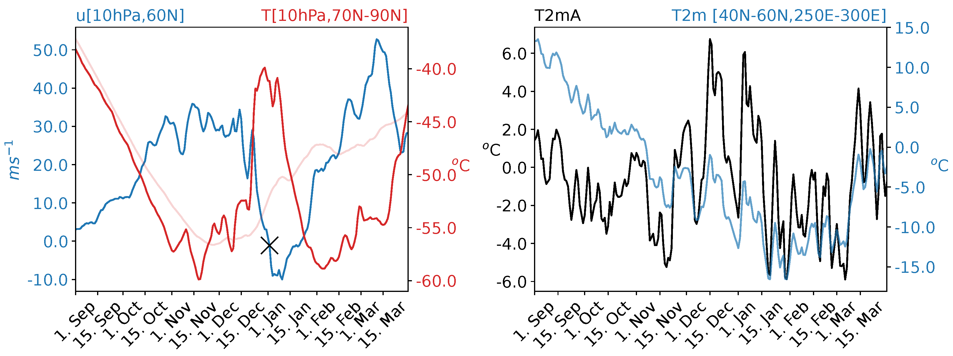
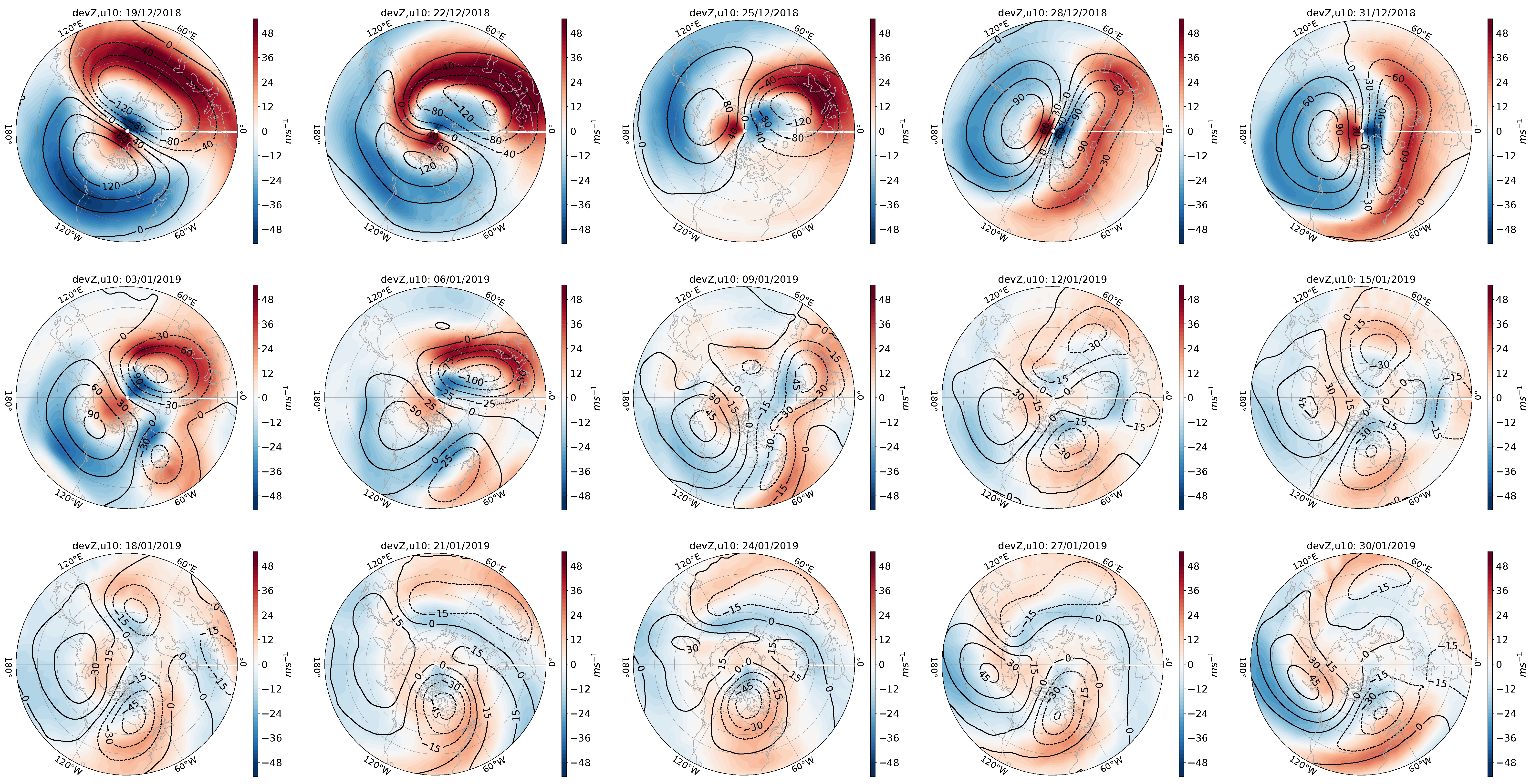
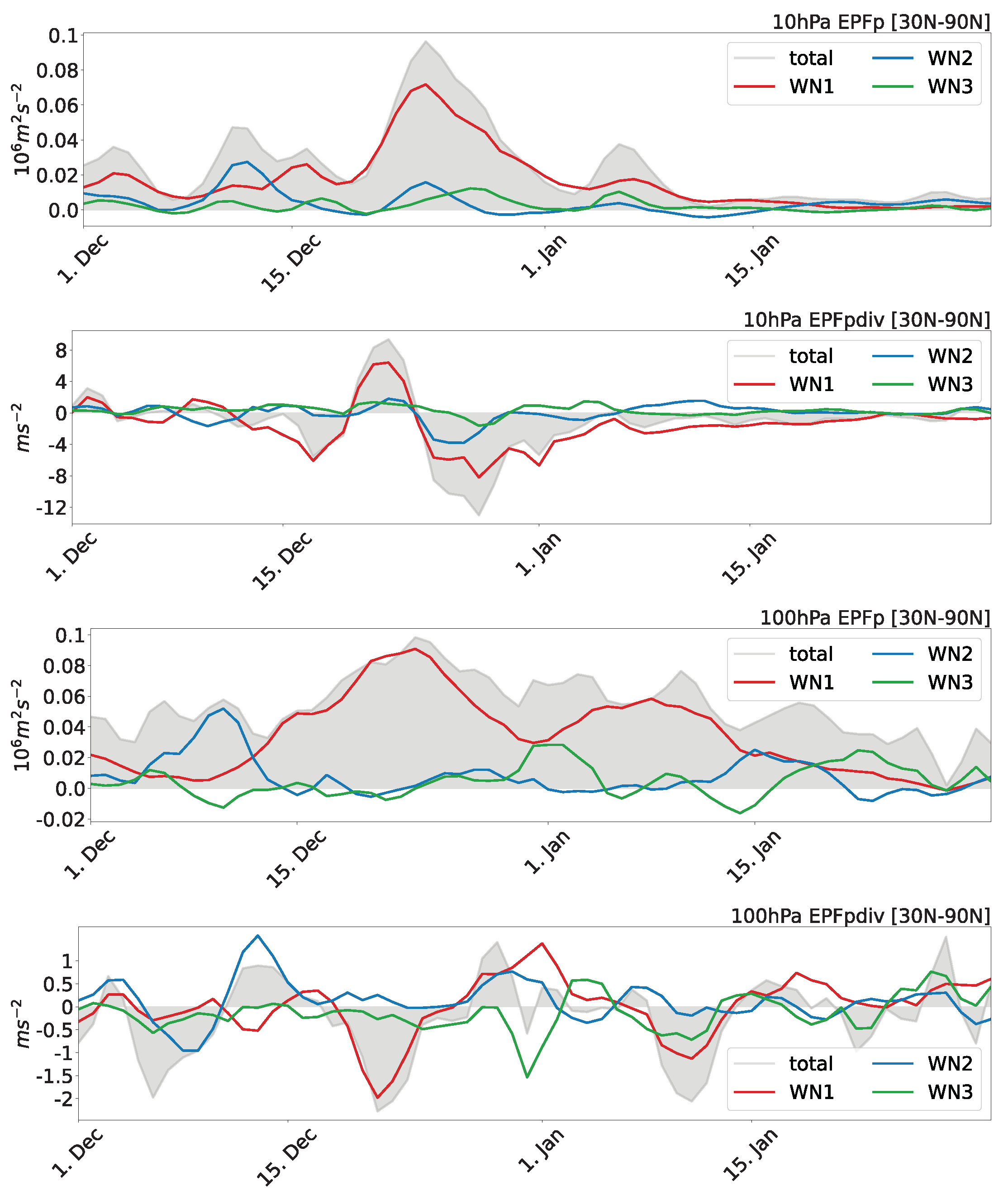
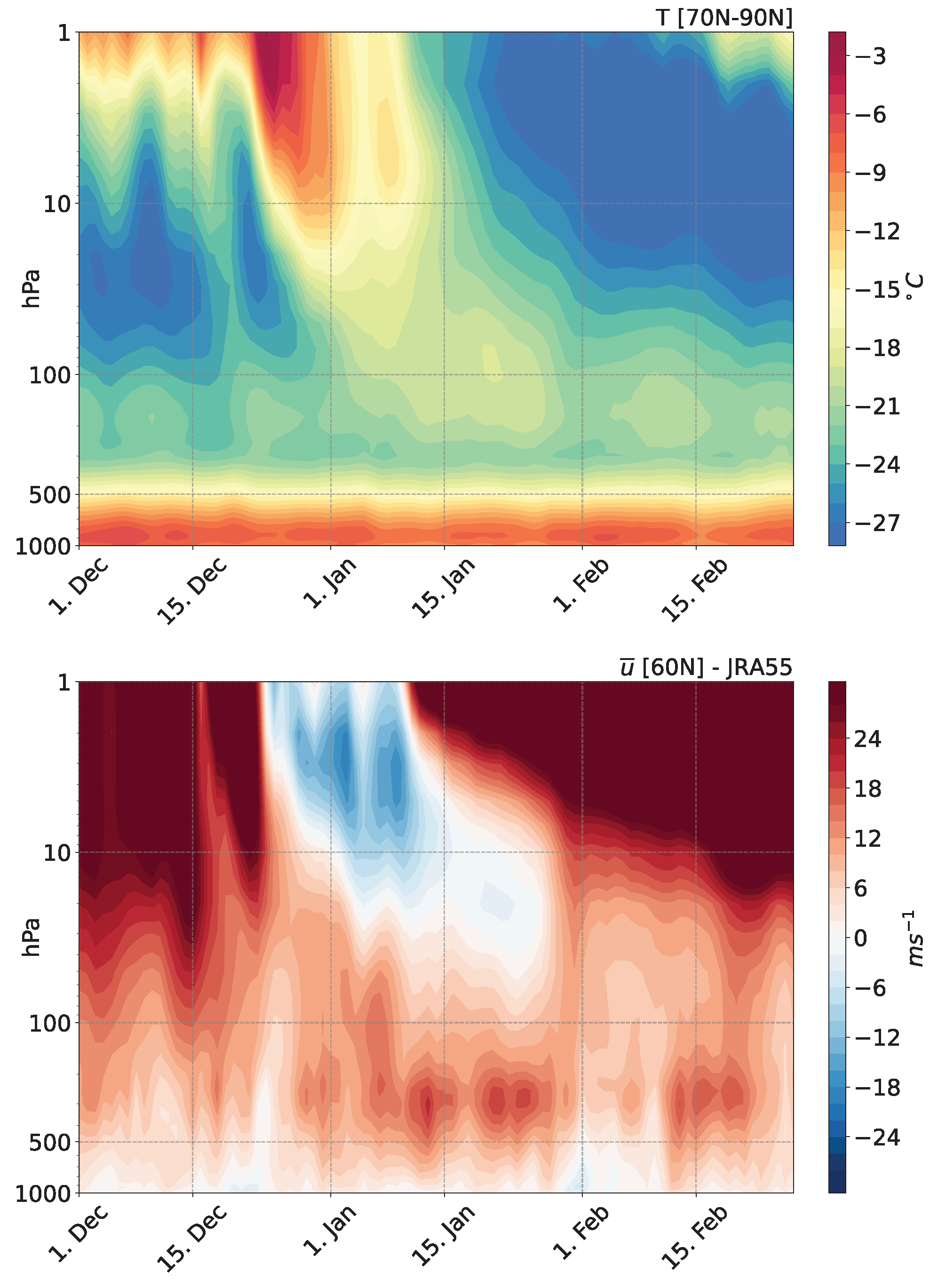
3.1. The 2018/2019 Sudden Stratospheric Warming

As a measure of an ongoing SSW, we start by examining the stratospheric polar temperature and the zonal mean zonal wind at 60° N. Figure 1 (left) shows the JRA-55 climatological seasonal cycle based on the period 1958–2021 (bright red), along with daily values for September 2018–March 2019 of 10 hPa polar temperature north of 70° N (dark red). Small disturbances were observed in early December 2018 and, starting from the last week of December, the temperature started to climb sharply, reaching −40 °C within a few days. After recovering slightly, the temperature started to increase again, reaching a second peak in the second week of January. The daily evolution of 10 hPa zonal mean zonal winds at 60° N (left panel of Figure 1; blue line) shows the reversal from westerly to easterly on 1 January 2019 (black cross), thus making the SSW classifiable as a major one. For slightly over a week, the easterlies stayed at similar negative levels before turning westerly again in the second half of January. Both unusually cold stratospheric temperatures and strong westerlies developed during February and March. The JRA-55 T2m (blue) and corresponding anomalies (black), averaged over North America [40° N–60° N; 250° E–300° E], show high day-to-day variability with alternating fluctuations of positive and negative anomalies, but with an overall decrease towards negative ones starting from the second half of December to late February (Figure 1; right). Coinciding with the evolution of stratospheric anomalies, the question that arises is whether or not there is a link between the major SSW and the cold North American surface temperatures.
To investigate the nature of the warming event in the stratosphere, Figure 2 shows evolution maps of 10 hPa geopotential height anomalies with respect to the zonal mean (contours) and the zonal wind (shading) at the same height every three days starting from 19 December 2018 (top left) to 30 January 2019 (bottom right). The date is indicated in each respective title. In mid- to late December 2018, the figure reveals a displaced vortex towards Eurasia, with a WN1 structure that stretches zonally with time. Easterlies are present over the North Pacific. In early January 2019, the anomalous pattern developed into a clear vortex split, although it does not seem to be a simple WN2 pattern. The zonal wind shows negative values at the southern flank of the enhanced Aleutian High throughout January.
From about 10 days into January (Figure 2; second row; right panels), the structure has WN3 features with negative height anomalies over North America, Siberia, and southern Europe in mid-January 2019. The lobe over eastern North America is quasi-stationary, starting from early January throughout the analyzed period. In general, however, SSW events with vortex splitting are associated with WN2, making this SSW a special one. The vortex split is interpreted to be caused by a WN3 contribution in this present case, as shown below.
To investigate the EP flux (Equation (1)) in the meridional plane, Figure 3 shows its vertical component E P F p and its divergence E P F p d i v at 10 hPa (top and upper middle) and 100 hPa (bottom and lower middle), latitude-weighted and averaged over 30° N–90° N for December and January. Averaging over slightly different latitudinal areas does not change the results substantially. However, it should be noted that the values are likely smaller due to averaging. Contributions are shown for WN1 (red), WN2 (blue), and WN3 (green), in addition to the total vertical EP flux from all zonal wavenumbers (gray). At both pressure levels, a strong WN2 forcing is visible in the first half of December (Figure 3 top and lower middle) that, however, decreases to values close to 0 by mid-December. In the second half of December, a WN2 contribution followed by a WN3 one is observed at 10 hPa, which decreased to values close to zero (WN3) and even below zero (WN2) around early January (Figure 3; top). At the same level in late December, the EP flux converges for WN2 and WN3, a proxy for the deceleration of the westerly flow (Figure 3; upper middle). Further, there is a continuous WN1 forcing from late December 2018 to mid-January 2019 at both levels (Figure 3; top and lower middle), which is possibly related to the displaced vortex with a WN1 structure, visible in Figure 2. This is consistent with WN1 EP flux convergence in 10 hPa in the last week of December (Figure 3; upper middle). At 100 hPa, around January 1st, 2019, there is a high WN3 value, while a WN2 EP flux contribution is unexpectedly not present (Figure 3; lower middle). In 10 hPa, WN3 convergence appears from about one week into January, with small negative values (Figure 3; upper middle). Note that the values of the WN3 are generally much smaller than, e.g., WN1 values. The WN3 pulse is interpreted as the cause for the split of the already displaced and zonally stretched vortex and supports the finding that the split pattern in geopotential height anomalies does not show a simple WN2 structure. Generally, the total EP-flux convergence in 10 hPa coincides with large WN3 contributions at the same height (Figure 3; top and upper middle).
The WN3 forcing at 100 hPa declines after about a week, before increasing again in the second half of January (Figure 3; lower middle). Around mid-January, positive WN2 contributions can be seen, particularly at 100 hPa. Further, while the total vertical component is positive, the WN3 contribution at 100 hPa is negative during parts of the first week of January as well as around January 15th (Figure 3; lower middle). A negative WN2 component appears during the second half of January. Negative values might indicate downward propagation of WN2 and WN3 planetary waves.
In the next step, we investigate the downward progression of the stratospheric signal. From Figure 4 (upper panel), showing the downward evolution of polar cap temperature north of 70° N, we can see that, at 10 hPa, the warming started around 20 December 2018 and continued to about 15 January 2019. The signal progressed downward in time but halted at lower stratospheric levels. The zonal mean zonal wind at 10 hPa and 60° N (Figure 4; lower panel) turned easterly on 1 January 2019, while the reversal took place earlier at higher levels. The progression of the easterlies seems to stop in the lower stratosphere at around 100 hPa. The effect can be seen until late January, while in the upper stratosphere strong westerlies develop again. The strong polar vortex that followed the SSW event may have influenced the cold surface temperatures in early February, something worth investigating in a future study. The AO index, which is based on the 1000 hPa level, shows a shift to negative values during parts of the first and second half of January. However, the NAO index is based on mid-tropospheric levels and was on the low-value positive side after the SSW, i.e., in a rather neutral state. Hence, tropospheric variability or other processes may have resulted in the canonical surface response to an SSW, i.e., the negative AO phase, instead of the downward progression of the stratospheric signal.
Summarizing the results of the analysis so far, we find that this event, dominated by WN1 and WN3 forcings, can be classified as a major SSW with a vortex split. This is reflected by the sharp increase in polar temperature in addition to a reversal of zonal mean zonal winds. The corresponding downward-progressing stratospheric anomalies stop at lower stratospheric levels.

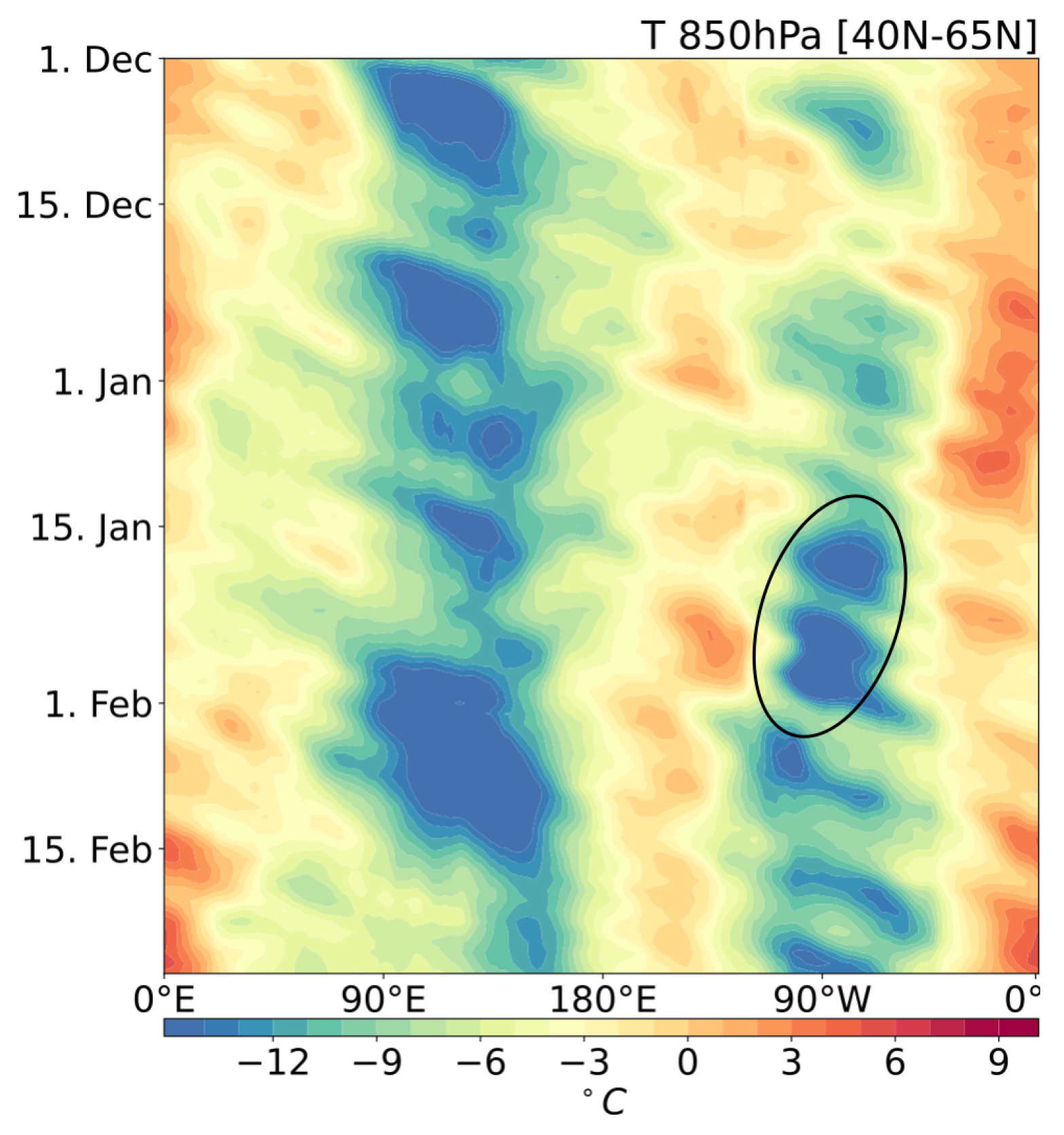
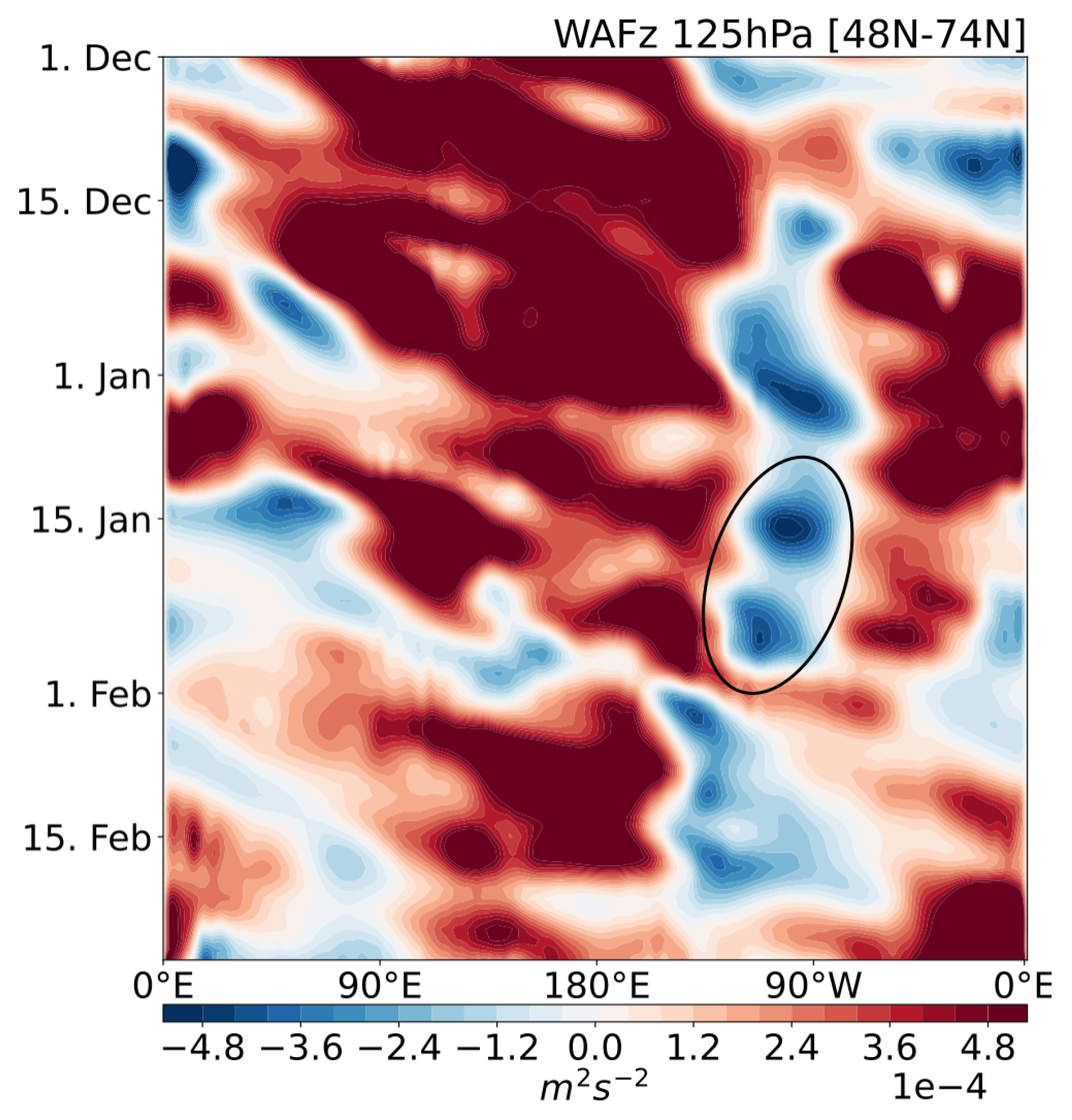
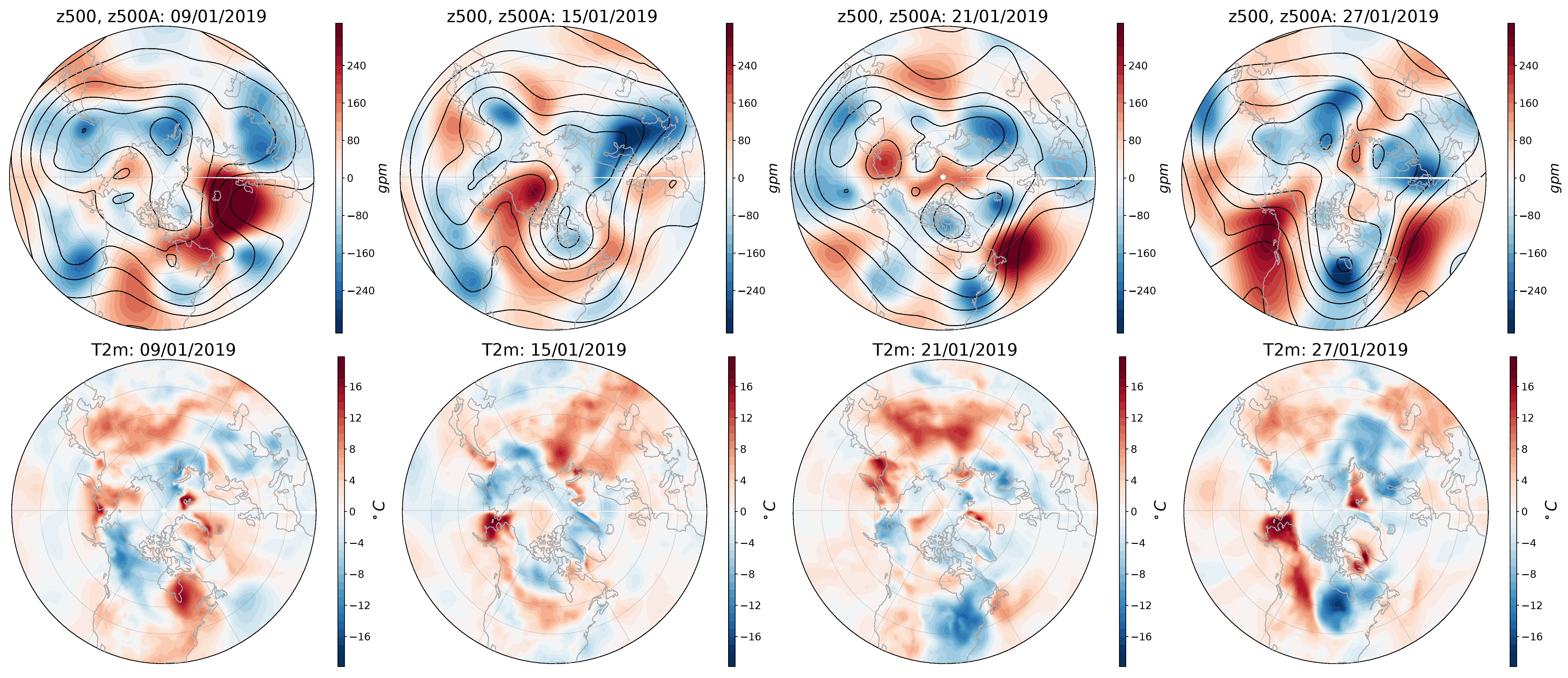
3.2. Surface Signature and the Role of Downward Propagating Wave Packets

Consistent with the evolution of T2m and corresponding anomalies (Figure 1), Figure 5 shows a time-longitude plot of 3-day running mean 850 hPa latitude-weighted temperatures averaged over 40° N–65° N for December 2018 to February 2019. December 1st is on top of the y-axis.
There is a clear cold region over the North American sector around 90° W, marked with the black ellipse. Particularly cold values are reached between mid-January to early February, with a peak around 25 January 2019. Note that the start of the extreme cold temperatures concurs roughly with downward propagating WN3 wave packets at 100 hPa in mid-January (see Figure 3; bottom panel). Further, we find a slight westward propagation of the cold temperature pattern. Interestingly, the location of cold temperatures in the North American sector coincides well with the position of one of the displaced vortices of the split SSW (see Figure 2).
The cold anomalies are also obtained using NCEP/DOE Reanalysis 2 data. Figure 6 shows the average of the T2m anomalies based on the daily climatological seasonal cycle for the first (top) and last (bottom) 15 days of January 2019. In particular, the decrease in North American T2m during the second half of January yields anomalously cold temperatures during the season. What is interesting is the switch from positive anomalies in the first half of January to negative ones later on. Further, cold anomalies are detected over Northern Africa and Western Europe.
As established in the previous section, an SSW occurred in early January 2019, but the downward progression of the stratospheric signal halted at lower stratospheric/tropopause levels. The canonical surface impact was largely absent [35,39], even though the AO index was negative for parts of January. However, record-breaking cold temperatures reached the eastern part of North America in the weeks after the onset of the SSW. In the following, we are investigating how the polar vortex and its breakdown are linked to the cold surface temperatures even though the stratospheric anomalies did not translate into the troposphere.
Following some SSWs, upward propagating planetary waves have been found to be reflected by the stratosphere back down into the troposphere [25,26]. To evaluate whether or not wave reflection may have played a role in the surface impact of the SSW 2019, we examine the vertical orientation of WAF (Equation (2)) during the analysis period. Figure 7 shows the time evolution of the vertical component W A F z of the three-dimensional Plumb WAF, latitude-weighted and averaged over 48° N–74° N in the lower stratosphere at 125 hPa. A 3-day running mean is applied. Between about 90° E and 135° W, WAFz is prominently directed upward during the analysis period, particularly in December. The associated upward traveling planetary wave packets are potentially responsible for the weakening stratospheric winds in upper levels and the SSW in 2019. Further, there is a clear strong downward wave packet centered around 90° W, i.e., eastern North America, from late December 2018 onward until late January. We observe a resemblance between the evolution of downward directed WAFz (marked with the black ellipse) and the cold temperatures at 850 hPa (Figure 5), with the latter exhibiting a subtle eastward shift and positive temporal offset.
Downward-directed WAF toward North America has been related to wave reflection over the North Pacific with an involvement of the Aleutian High (e.g., [25,30,32,33]). In the following, we investigate whether or not this was also the case in 2019. We analyze the fields during the ongoing SSW starting about a week before the cold temperatures in eastern North America arose. Figure 8 shows two-dimensional longitude-height plots of 3-day running mean WAF for levels above 700 hPa (arrows) and eddy geopotential height anomalies with respect to the zonal mean (contours), both latitude-weighted and averaged over 48° N–74° N, as well as zonal wind (shading) at 60° N. Representative for the different stages of the evolution in 2019, four dates have been selected: January 9th (top left), January 15th (top right), January 21st (bottom left), and January 27th (bottom right). For the same dates, Figure 9 displays 500 hPa geopotential height (contours) and corresponding anomalies (shading) with respect to the climatology in the top row as well as the T2m anomaly patterns in the bottom row. Complementing this, the evolution of the blocking index based on [51] is shown in Figure 10.
On January 9th (Figure 8; top left), the ongoing SSW is clearly visible. Easterlies dominate the upper levels across longitudes reaching down to the mid-stratosphere. The barotropically developing trough around 70° W divides the usually baroclinic Aleutian High near 50 hPa, leading to it having a quasi-barotropic feature in the lower stratosphere. The development of the trough is seemingly brought about by the WN3 forcing (see Figure 3). Indicated by the WAF, planetary waves propagate upwards around 150° E as well as over the North Atlantic around 20° W. The latter region is co-located with a strong anticyclonic anomaly that stretches from the lower troposphere to the middle stratosphere. A pair of negative and positive geopotential height anomalies, located over the eastern North Pacific and western/central North America, respectively, develops (Figure 9; first column). This pattern promotes negative T2m anomalies over northwestern North America.
Positive temperature anomalies are visible over North America’s northeastern part. Further, a mid-tropospheric anticyclone over the North Pacific at 170° E blocks the flow (see Figure 10). On January 15th (Figure 8; top left), the stratospheric trough over eastern North America and the resulting quasi-barotropic structure of the Aleutian High are more evident, and upward propagating waves over the eastern North Pacific around 150° W reflect at the lower stratospheric part of the Aleutian High down toward North America around 90° W, where they converge. This subsequently yields a deepening of the co-located troughs in the troposphere. In particular, the wave path can be attributed to the eddy geopotential height pattern, i.e., westward tilt at the western flank and eastward tilt on the eastern flank of the Aleutian High. The downward extension of the stratospheric Aleutian High into tropospheric levels is imprinted in the 500 hPa geopotential height field as the western North American ridge that merges with the blocking anticyclone over the central North Pacific (Figure 9; second column). The blocking index in Figure 10 indicates a blocked flow at around 150° W around mid-January.
Negative T2m anomalies can be observed in Northern Canada. The downward wave propagation continues in the following days and results in a connection between the stratospheric and tropospheric negative eddy geopotential height anomalies over eastern North America. The former are attributed to one of the stratospheric polar vortex centers (see Figure 2). As the 500 hPa trough deepens further over time, it eventually merges with a negative geopotential height anomaly over eastern North America. Concomitantly, a strong anticyclonic anomaly develops over the North Atlantic to the south of Greenland that has a quasi-barotropic phase structure in the upper troposphere and lower stratosphere on January 21st (Figure 8; bottom left, and Figure 9; third column). Negative temperature anomalies have developed over the eastern part of North America. Blocking develops over the North Pacific around 170° E (Figure 10), which is amplified with time. In response, the ridge over the eastern North Pacific strengthens and connects to lower stratospheric levels in the following days. This pattern is referred to as the Alaskan ridge regime by [52], transitioning from a pattern in early January resembling the Pacific trough regime. Further, the waves that propagate upward around 180° are reflected back down and converge at the trough around 90° W during the days leading up to January 27th (Figure 8; bottom right). The ridge-trough pair over the eastern North Pacific and eastern North America is quasi-stationary for the rest of the month starting from January 23rd. Consequently, the already cold temperatures over eastern North America are reinforced through continuous cold polar air advection (Figure 9; fourth column).

4. Summary and Conclusions

Severe cold weather hit parts of North America in the second half of January 2019, particularly the Midwest, Eastern US, and Canada. Low temperature records have been observed, with many casualties and great material losses. Consistent with earlier case studies [35,36,37,38,39,40,41], we find that a major SSW occurred with a zonal mean zonal wind reversal at 10 hPa and 60° N on 1 January 2019, along with an abrupt and strong increase of stratospheric polar cap temperatures. The zonal mean zonal wind stayed easterly for almost three weeks. In this event, a persistent upward WN1 planetary wave flux led to a displaced polar vortex toward Eurasia. A brief, strong WN3 pulse prompted the vortex to split, resulting in a geopotential height structure with WN3 features, i.e., centers over Siberia, southern Europe, and North America. Among them, the daughter vortex over North America made the usually baroclinic structure of the Aleutian High quasi-barotropic. In particular, it remained quasi-stationary during the whole analysis period until late January. Expected WN2 EP fluxes [12,13,14], on the other hand, were close to zero during the ongoing vortex split. Hence, the combination of the WN1 forcing and the WN3 pulse, along with the associated geopotential height pattern in 10 hPa, make this event extraordinary.
Consistent with, for example, ref. [35,39], we find the downward progression of stratospheric anomalies to stall in the lower stratosphere and fail to translate to canonical tropospheric anomalies. However, in agreement with the analysis by [16], we find cold temperatures over North America, western Europe, and North Africa in the aftermath of the SSW split event. The development of some North American cold spells has been attributed to stratospheric wave reflection [30,31,32,33] and downward directed waves traveling towards North America. While a relation between a sudden switch from a North Pacific trough to a ridge and North American wave reflection events (e.g., [32]) is similarly observed in the 2019 case, many of the referenced studies do not find a strong relation between SSWs and wave reflection events that involve North American cold spells. Instead, they find them to occur under rather neutral conditions [30,33] or onset under even strong stratospheric polar vortex conditions [31] before the polar vortex is displaced toward Eurasia by the Aleutian High and stretched [32]. In fact, the 2019 North American cold spell has not been identified as a wave reflection event by the algorithms used in [30,31,32], which could be because, in 2019, the waves were reflected in the lower stratosphere instead of higher up.
Nevertheless, this study shows that, similar to the case study by [25], wave reflection in the second half of January was involved in the North American cold event: Cold 850 hPa temperatures, located slightly east and with a positive temporal offset compared to negative WAFz, move westward with time over North America. Guided by the structure of positive and negative eddy geopotential height anomalies that stretched from the stratosphere to the surface, upward propagating wave packets over the North Pacific were reflected at the lower edge of the stratospheric Aleutian High toward North America and eventually converged at the center of a mid-tropospheric cyclonic anomaly. Subsequently, the trough deepened and eventually connected to one center of the split stratospheric polar vortex. An upstream anticyclonic anomaly over the North Atlantic develops and the Aleutian High stretches from the troposphere to the lower stratosphere. The whole structure becomes quasi-stationary, yielding continuous cold air advection toward North America. The spatial and temporal overlap of the converging wave packets and the deepening trough, resulting in a pattern that is conducive to North American cold temperatures, strongly suggests their interconnection. Further, as discussed in [25], blocking developed over the North Pacific. The unusual WN3 forcing and structure of stratospheric height anomalies as well as the SSWs attribution to wave reflection emphasize the importance of individual, case-to-case analysis of how the stratosphere may interact with the troposphere. Their continued study is strongly needed and highly relevant for improving the extended-range prediction of extremes at the surface and their mitigation.

Author Contributions

A.H. conceptualized the research; A.H. and K.F. wrote the manuscript draft; K.F. performed the data analysis and data visualization; Y.M. and W.I. partially curated and visualized data; A.H., K.F., and T.H. reviewed and edited the manuscript. All authors have read and agreed to the published version of the manuscript.

Funding

The computations and data handling were partly enabled by resources provided by Kyushu University, Department of Planetary Sciences, and partly by the Swedish National Infrastructure for Computing (SNIC) at the National Supercomputer Centre (NSC), partially funded by the Swedish Research Council through grant agreement no. 2018–05973. T. Hirooka was funded by the International Meteorological Institute (IMI) of Stockholm University, Stockholm, Sweden, and he was also supported by KAKENHI, Grant numbers JP20H01973 and JP18H01280. K.F. acknowledges support for a research visit at Kyushu University from the Department of Planetary Sciences, Kyushu University. K.F. was supported by a faculty-funded PhD program.

Data Availability Statement

The JRA-55 Reanalysis data can be obtained from the Japan Meteorological Agency. The AO and NAO index can be retrieved at NOAA’s Climate Prediction Center. The code for calculating 3D WAF is available upon request.

Acknowledgments

We acknowledge the Japan Meteorological Agency (JMA) for providing the JRA-55 reanalysis. We further acknowledge NOAA PSL, Boulder, Colorado, USA, for providing the NCEP/DOE Reanalysis II data. We acknowledge the constructive feedback of four anonymous reviewers, whose insightful comments and suggestions have significantly improved this manuscript.

Conflicts of Interest

The authors declare no conflicts of interest. The funders had no role in the design of the study; in the collection, analyses, or interpretation of data; in the writing of the manuscript; or in the decision to publish the results.

References

  1. Wang, T.; Zhang, Q.; Hannachi, A.; Lin, Y.; Hirooka, T. On the dynamics of the seasonal transitions in the two hemispheric high-latitude stratosphere. Tellus A 2019, 71, 1634949. [Google Scholar] [CrossRef]
  2. Baldwin, M.P.; Dunkerton, T.J. Stratospheric Harbingers of Anomalous Weather Regimes. Science 2001, 294, 581–584. [Google Scholar] [CrossRef]
  3. Vitart, F.A.R.; Anderson, D. Subseasonal to Seasonal Prediction Project: Bridging the gap between weather and climate. WMO Bull. 2012, 61, 23–28. [Google Scholar]
  4. Rao, J.; Garfinkel, C.I.; Butler, A.H. Chapter 14—Stratospheric polar vortex variability. In Atmospheric Oscillations; Guan, B., Ed.; Elsevier: Amsterdam, The Netherlands, 2025; pp. 277–299. [Google Scholar] [CrossRef]
  5. Thompson, D.W.J.; Baldwin, M.P.; Wallace, J.M. Stratospheric Connection to Northern Hemisphere Wintertime Weather: Implications for Prediction. J. Clim. 2002, 15, 1421–1428. [Google Scholar] [CrossRef]
  6. O’Neill, A.; Charlton-Perez, A.; Polvani, L. MIDDLE ATMOSPHERE—Stratospheric Sudden Warmings. In Encyclopedia of Atmospheric Sciences, 2nd ed.; North, G.R., Pyle, J., Zhang, F., Eds.; Academic Press: Oxford, UK, 2015; pp. 30–40. [Google Scholar] [CrossRef]
  7. Varotsos, C.A.; Cracknell, A.P.; Tzanis, C. The exceptional ozone depletion over the Arctic in January–March 2011. Remote. Sens. Lett. 2012, 3, 343–352. [Google Scholar] [CrossRef]
  8. Varotsos, C.; Efstathiou, M.; Christodoulakis, J. The lesson learned from the unprecedented ozone hole in the Arctic in 2020; A novel nowcasting tool for such extreme events. J. Atmos. Sol.-Terr. Phys. 2020, 207, 105330. [Google Scholar] [CrossRef]
  9. Charney, J.G.; Drazin, P.G. Propagation of planetary-scale disturbances from the lower into the upper atmosphere. J. Geophys. Res. 1961, 66, 83–109. [Google Scholar] [CrossRef]
  10. Andrews, D.G.; Holton, J.R.; Leovy, C.B. Middle Atmosphere Dynamics, 1st ed.; Academic Press: Cambridge, MA, USA, 1987. [Google Scholar]
  11. Hannachi, A.; Mitchell, D.; Gray, L.; Charlton-Perez, A. On the use of geometric moments to examine the continuum of sudden stratospheric warmings. J. Atmos. Sci. 2011, 68, 657–674. [Google Scholar] [CrossRef]
  12. Bancalá, S.; Krüger, K.; Giorgetta, M. The preconditioning of major sudden stratospheric warmings. J. Geophys. Res. Atmos. 2012, 117., D04101. [Google Scholar] [CrossRef]
  13. Kidson, J.; Scaife, A.A.; Hardiman, S.C.; Mitchell, D.M.; Butchart, N.; Baldwin, M.P.; Gray, L.J. Stratospheric influence on tropospheric jet streams, storm tracks and surface weather. Nat. Geosci. 2015, 8, 433–440. [Google Scholar] [CrossRef]
  14. Harada, Y.; Hirooka, T. Extraordinary Features of the Planetary Wave Propagation During the Boreal Winter 2013/2014 and the Zonal Wave Number Two Predominance. J. Geophys. Res. Atmos. 2017, 122, 11374–11387. [Google Scholar] [CrossRef]
  15. Liu, S.M.; Chen, Y.H.; Rao, J.; Cao, C.; Li, S.Y.; Ma, M.H.; Wang, Y.B. Parallel Comparison of Major Sudden Stratospheric Warming Events in CESM1-WACCM and CESM2-WACCM. Atmosphere 2019, 10, 679. [Google Scholar] [CrossRef]
  16. Mitchell, D.M.; Gray, L.J.; Anstey, J.; Baldwin, M.P.; Charlton-Perez, A.J. The Influence of Stratospheric Vortex Displacements and Splits on Surface Climate. J. Clim. 2013, 26, 2668–2682. [Google Scholar] [CrossRef]
  17. Baldwin, M.P.; Dunkerton, T.J. Propagation of the Arctic Oscillation from the stratosphere to the troposphere. J. Geophys. Res. Atmos. 1999, 104, 30937–30946. [Google Scholar] [CrossRef]
  18. Julian, P.R.; Labitzke, K.B. A study of atmospheric energetics during the January-February 1963 stratospheric warming. J. Atmos. Sci. 1965, 22, 597–610. [Google Scholar] [CrossRef]
  19. Quiroz, R.S. Tropospheric-stratospheric polar vortex breakdown of January 1977. Geophys. Res. Lett. 1977, 4, 151–154. [Google Scholar] [CrossRef]
  20. Thompson, D.W.; Wallace, J.M. Annular modes in the extratropical circulation. Part I: Month-to-month variability. J. Clim. 2000, 13, 1000–1016. [Google Scholar] [CrossRef]
  21. Iqbal, W.; Hannachi, A.; Hirooka, T.; Chafik, L.; Harada, Y. Troposphere-stratosphere dynamical coupling in regard to the North Atlantic eddy-driven jet variability. J. Meteorol. Soc. Jpn. 2019, 97, 657–671. [Google Scholar] [CrossRef]
  22. Cao, C.; Chen, Y.H.; Rao, J.; Liu, S.M.; Li, S.Y.; Ma, M.H.; Wang, Y.B. Statistical Characteristics of Major Sudden Stratospheric Warming Events in CESM1-WACCM: A Comparison with the JRA55 and NCEP/NCAR Reanalyses. Atmosphere 2019, 10, 519. [Google Scholar] [CrossRef]
  23. Liang, Z.; Rao, J.; Guo, D.; Lu, Q.; Shi, C. Northern winter stratospheric polar vortex regimes and their possible influence on the extratropical troposphere. Clim. Dyn. 2023, 60, 3167–3186. [Google Scholar] [CrossRef]
  24. Kodera, K.; Mukougawa, H.; Itoh, S. Tropospheric impact of reflected planetary waves from the stratosphere. Geophys. Res. Lett. 2008, 35, L16806. [Google Scholar] [CrossRef]
  25. Kodera, K.; Mukougawa, H.; Fujii, A. Influence of the vertical and zonal propagation of stratospheric planetary waves on tropospheric blockings. J. Geophys. Res. Atmos. 2013, 118, 8333–8345. [Google Scholar] [CrossRef]
  26. Kodera, K.; Mukougawa, H.; Maury, P.; Ueda, M.; Claud, C. Absorbing and reflecting sudden stratospheric warming events and their relationship with tropospheric circulation. J. Geophys. Res. Atmos. 2016, 121, 80–94. [Google Scholar] [CrossRef]
  27. Perlwitz, J.; Harnik, N. Observational Evidence of a Stratospheric Influence on the Troposphere by Planetary Wave Reflection. J. Clim. 2003, 16, 3011–3026. [Google Scholar]
  28. Perlwitz, J.; Harnik, N. Downward Coupling between the Stratosphere and Troposphere: The Relative Roles of Wave and Zonal Mean Processes. J. Clim. 2004, 17, 4902–4909. [Google Scholar] [CrossRef]
  29. Shaw, T.A.; Perlwitz, J.; Harnik, N. Downward Wave Coupling between the Stratosphere and Troposphere: The Importance of Meridional Wave Guiding and Comparison with Zonal-Mean Coupling. J. Clim. 2010, 23, 6365–6381. [Google Scholar] [CrossRef]
  30. Matthias, V.; Kretschmer, M. The Influence of Stratospheric Wave Reflection on North American Cold Spells. Mon. Weather. Rev. 2020, 148, 1675–1690. [Google Scholar] [CrossRef]
  31. Millin, O.T.; Furtado, J.C.; Basara, J.B. Characteristics, Evolution, and Formation of Cold Air Outbreaks in the Great Plains of the United States. J. Clim. 2022, 35, 4585–4602. [Google Scholar] [CrossRef]
  32. Messori, G.; Kretschmer, M.; Lee, S.H.; Wendt, V. Stratospheric downward wave reflection events modulate North American weather regimes and cold spells. Weather. Clim. Dyn. 2022, 3, 1215–1236. [Google Scholar] [CrossRef]
  33. Kretschmer, M.; Cohen, J.; Matthias, V.; Runge, J.; Coumou, D. The different stratospheric influence on cold-extremes in Eurasia and North America. npj Clim. Atmos. Sci. 2018, 1, 44. [Google Scholar] [CrossRef]
  34. Lu, Q.; Rao, J.; Ren, R.; Shi, C.; Liu, S. Enhanced stratosphere-troposphere and tropics-Arctic couplings in the 2023/24 winter. Commun. Earth Environ. 2024, 5, 631. [Google Scholar] [CrossRef]
  35. Lee, S.H.; Butler, A.H. The 2018–2019 Arctic stratospheric polar vortex. Weather 2020, 75, 52–57. [Google Scholar] [CrossRef]
  36. Butler, A.H.; Lawrence, Z.D.; Lee, S.H.; Lillo, S.P.; Long, C.S. Differences between the 2018 and 2019 stratospheric polar vortex split events. Q. J. R. Meteorol. Soc. 2020, 146, 3503–3521. [Google Scholar] [CrossRef]
  37. Ma, Z.; Gong, Y.; Zhang, S.; Luo, J.; Zhou, Q.; Huang, C.; Huang, K. Comparison of stratospheric evolution during the major sudden stratospheric warming events in 2018 and 2019. Earth Planet. Phys. 2020, 4, 493–503. [Google Scholar] [CrossRef]
  38. Roy, R.; Kuttippurath, J. The dynamical evolution of Sudden Stratospheric Warmings of the Arctic winters in the past decade 2011–2021. SN Appl. Sci. 2022, 4, 105. [Google Scholar] [CrossRef]
  39. Knight, J.; Scaife, A.; Bett, P.E.; Collier, T.; Dunstone, N.; Gordon, M.; Hardiman, S.; Hermanson, L.; Ineson, S.; Kay, G.; et al. Predictability of European Winters 2017/2018 and 2018/2019: Contrasting influences from the Tropics and stratosphere. Atmos. Sci. Lett. 2021, 22, e1009. [Google Scholar] [CrossRef]
  40. Rao, J.; Garfinkel, C.I.; Chen, H.; White, I.P. The 2019 New Year Stratospheric Sudden Warming and Its Real-Time Predictions in Multiple S2S Models. J. Geophys. Res. Atmos. 2019, 124, 11155–11174. [Google Scholar] [CrossRef]
  41. Rao, J.; Garfinkel, C.I.; White, I.P. Predicting the Downward and Surface Influence of the February 2018 and January 2019 Sudden Stratospheric Warming Events in Subseasonal to Seasonal (S2S) Models. J. Geophys. Res. Atmos. 2020, 125, e2019JD031919. [Google Scholar] [CrossRef]
  42. Toptunova, O.; Motsakov, M.; Koval, A.; Ermakova, T.; Didenko, K. Impact of sudden stratospheric warming on tropospheric circulation and a cold wave formation: The case of the January 2019 event. Atmos. Res. 2025, 318, 107998. [Google Scholar] [CrossRef]
  43. Kobayashi, S.; Ota, Y.; Harada, Y.; Ebita, A.; Moriya, M.; Onoda, H.; Onogi, K.; Kamahori, H.; Kobayashi, C.; Endo, H.; et al. The JRA-55 Reanalysis: General specifications and basic characteristics. J. Meteorol. Soc. Jpn. 2015, 93, 5–48. [Google Scholar] [CrossRef]
  44. Harada, Y.; Kamahori, H.; Kobayashi, C.; Endo, H.; Kobayashi, S.; Ota, Y.; Onoda, H.; Onogi, K.; Miyaoka, K.; Takahashi, K. The JRA-55 Reanalysis: Representation of atmospheric circulation and climate variability. J. Meteorol. Soc. Jpn. 2016, 94, 269–302. [Google Scholar] [CrossRef]
  45. Kanamitsu, M.; Ebisuzaki, W.; Woollen, J.; Yang, S.K.; Hnilo, J.; Fiorino, M.; Potter, G.L. NCEP-DOE AMIP-II Reanalysis (R-2). Bull. Am. Meteorol. Soc. 2002, 83, 1631–1643. [Google Scholar] [CrossRef]
  46. CPC. AO and NAO Index from Climate Prediction Center of the National Oceanographic and Atmospheric Administration/National Weather Service. Available online: https://www.cpc.ncep.noaa.gov/products/precip/CWlink/daily_ao_index/teleconnections.shtml (accessed on 1 February 2023).
  47. Andrews, D.G. On the interpretation of the eliassen-palm flux divergence. Q. J. R. Meteorol. Soc. 1987, 113, 323–338. [Google Scholar] [CrossRef]
  48. Jucker, M. Scaling of Eliassen-Palm flux vectors. Atmos. Sci. Lett. 2021, 22, e1020. [Google Scholar] [CrossRef]
  49. Hannachi, A.; Lechner, M.; Finke, K.; Mukhin, D. Stratospheric polar vortex, wave absorption/reflection and effect on surface climate. Clim. Dyn. 2025, 63, 126. [Google Scholar] [CrossRef]
  50. Plumb, R.A. On the Three-Dimensional Propagation of Stationary Waves. J. Atmos. Sci. 1985, 42, 217–229. [Google Scholar] [CrossRef]
  51. Tibaldi, S.; Molteni, F. On the operational predictability of blocking. Tellus A 1990, 42, 343–365. [Google Scholar] [CrossRef]
  52. Lee, S.H.; Furtado, J.C.; Charlton-Perez, A.J. Wintertime North American Weather Regimes and the Arctic Stratospheric Polar Vortex. Geophys. Res. Lett. 2019, 46, 14892–14900. [Google Scholar] [CrossRef]
Figure 1. Left: JRA-55 daily September 2018–March 2019 zonal mean zonal wind at 60° N (blue; left axis) and polar temperature [70° N–90° N] (dark red; right axis) along with 1958–2021 seasonal cycle climatology of the latter (bright red; right axis), both at the 10 hPa level. The black cross marks the date of zonal mean zonal wind reversal. Right: JRA-55 daily September 2018–March 2019 T2m (blue; right axis) averaged over [40° N–60° N; 250° E–300° E], together with corresponding anomalies with respect to the seasonal cycle (black; left axis).
Atmosphere 16 00445 g001
Figure 2. 10 hPa evolution maps of eddy geopotential height anomalies with respect to the zonal mean (contours) and zonal wind (shading) for every three days from 19 December 2018 (top left) to 30 January 2019 (bottom right).
Atmosphere 16 00445 g002
Figure 3. Vertical component of daily EP flux and its divergence at 10 hPa (top and upper middle) and 100 hPa (lower middle and bottom) latitude-weighted and averaged over 30° N–90° N during the 2018/19 winter. The colors refer to zonal WN1 (red), WN2 (blue), and WN3 (green). The total wave contribution is shown by the gray color.
Atmosphere 16 00445 g003
Figure 4. Height-time plot of the daily polar cap temperature, latitude-weighted and averaged over 70° N–90° N in °C (top) and zonal-mean zonal wind at 60° N in m/s (bottom) for the 2018/19 winter. Absolute values are shown.
Atmosphere 16 00445 g004
Figure 5. Longitude-time plot of absolute values of 850 hPa temperature averaged over 40° N–65° N for the 2018/19 winter. Units, °C.
Atmosphere 16 00445 g005
Figure 6. T2m anomalies averaged over the first (top) and the second (bottom) half of January 2019 based on NCEP/DOE Reanalysis 2.
Atmosphere 16 00445 g006
Figure 7. Longitude-time plot of the vertical component of 3-day running mean WAF, latitude-weighted and averaged between 48° N–74° N at 125 hPa during the 2018/2019 winter. Units, m2 s−2.
Atmosphere 16 00445 g007
Figure 8. Longitude-height plots of 3-day running mean WAF (arrows) above 700 hPa, deviation geopotential height with respect to the zonal mean (contours), both latitude-weighted and averaged over 48° N–74° N as well as zonal wind at 60° N (shading; orange (purple) indicate easterlies (westerlies)). Fields are plotted for January 9th (top left), January 15th (top right), January 21st (bottom left), and January 27th (bottom right).
Atmosphere 16 00445 g008
Figure 9. Top row: 500 hpa geopotential height (contours) and corresponding anomalies with respect to the climatology (shading). Bottom row: T2m anomalies (shading). Fields are plotted for 9th January, 15th January, 21st January, and 27th January, 2019 (from left to right).
Atmosphere 16 00445 g009
Figure 10. Blocking index based on [51]. The strength of blocking is given by GHGL (Equation (3)). Unit: gpm/latitude.
Atmosphere 16 00445 g010
Disclaimer/Publisher’s Note: The statements, opinions and data contained in all publications are solely those of the individual author(s) and contributor(s) and not of MDPI and/or the editor(s). MDPI and/or the editor(s) disclaim responsibility for any injury to people or property resulting from any ideas, methods, instructions or products referred to in the content.

