Flood Hazard Assessment in Data-Scarce Watersheds Using Model Coupling, Event Sampling, and Survey Data

 ,
,  , and
, and
Abstract
1. Introduction
2. Materials and Methods
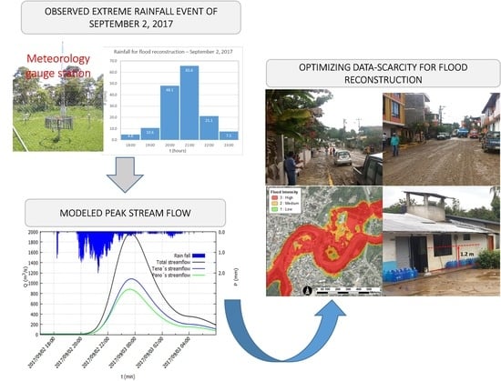
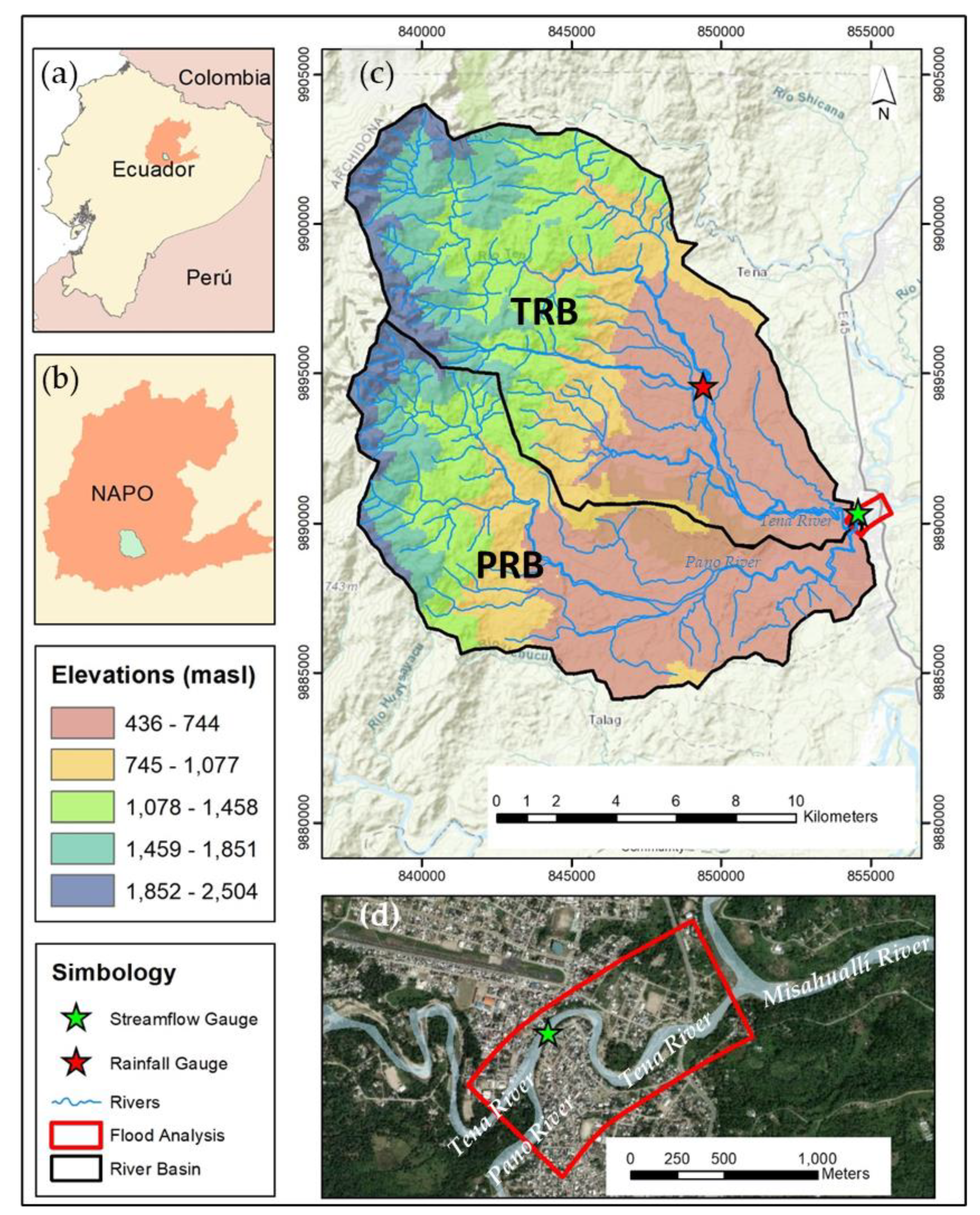
2.1. Study Area
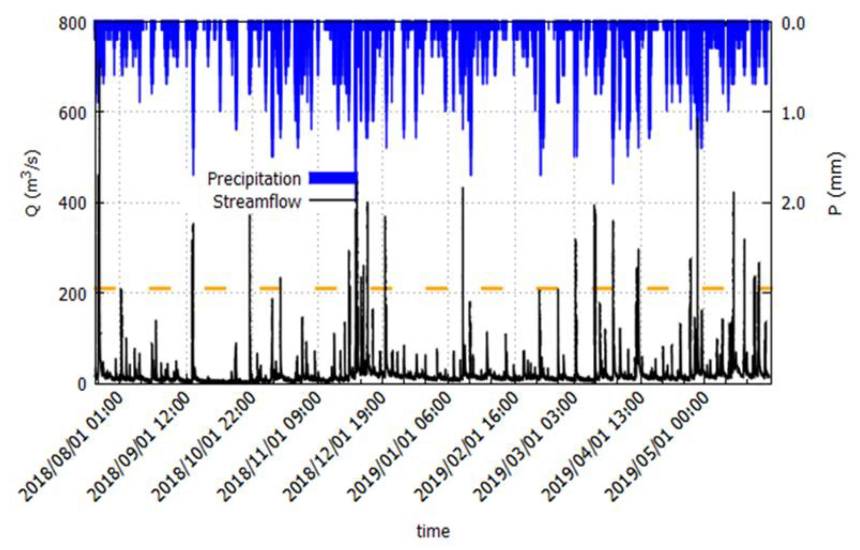
2.2. Data
2.3. Hydrological Modeling
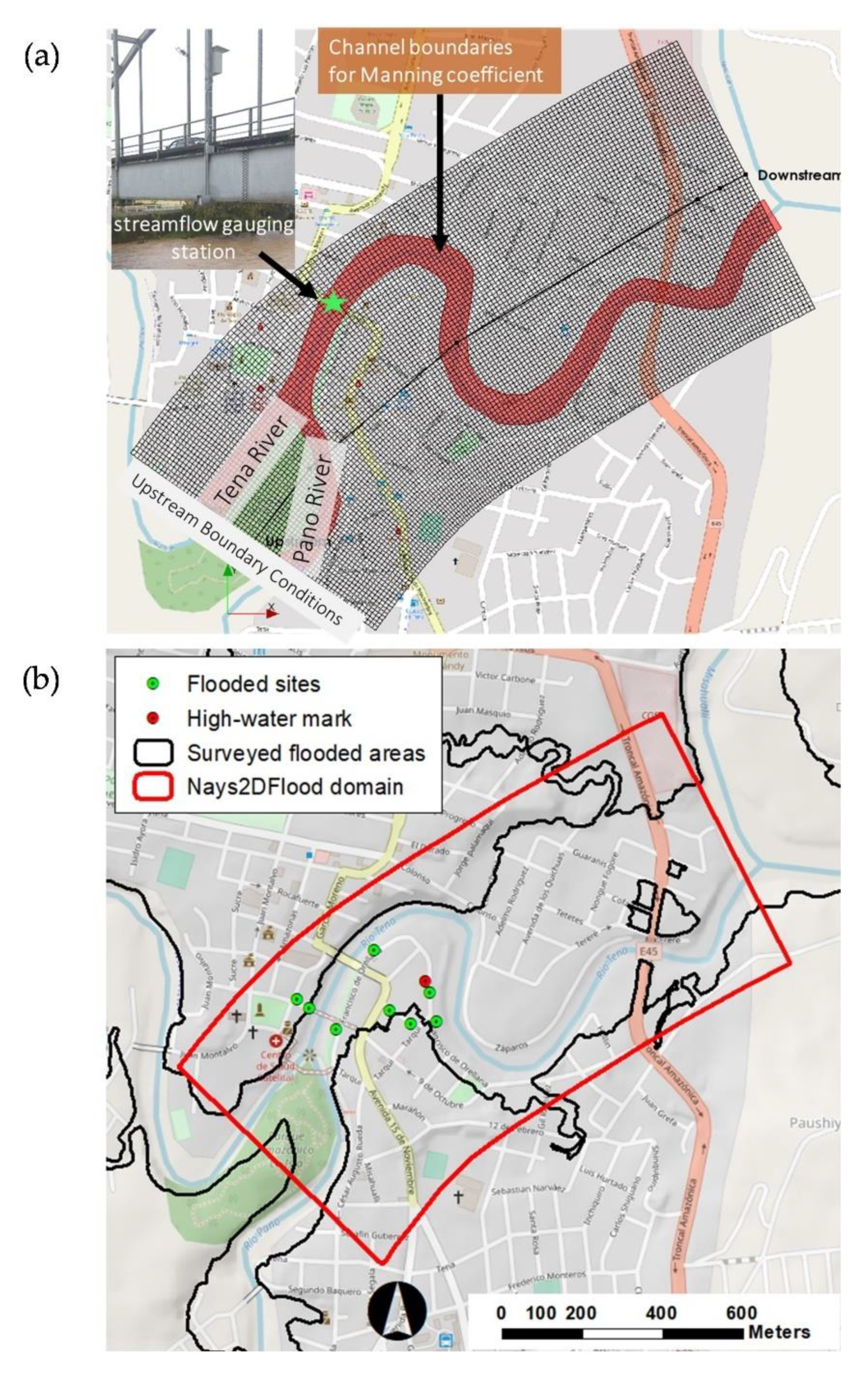
2.4. Hydrodynamic Modeling
2.5. Flood Hazard Mapping
3. Results and Discussion
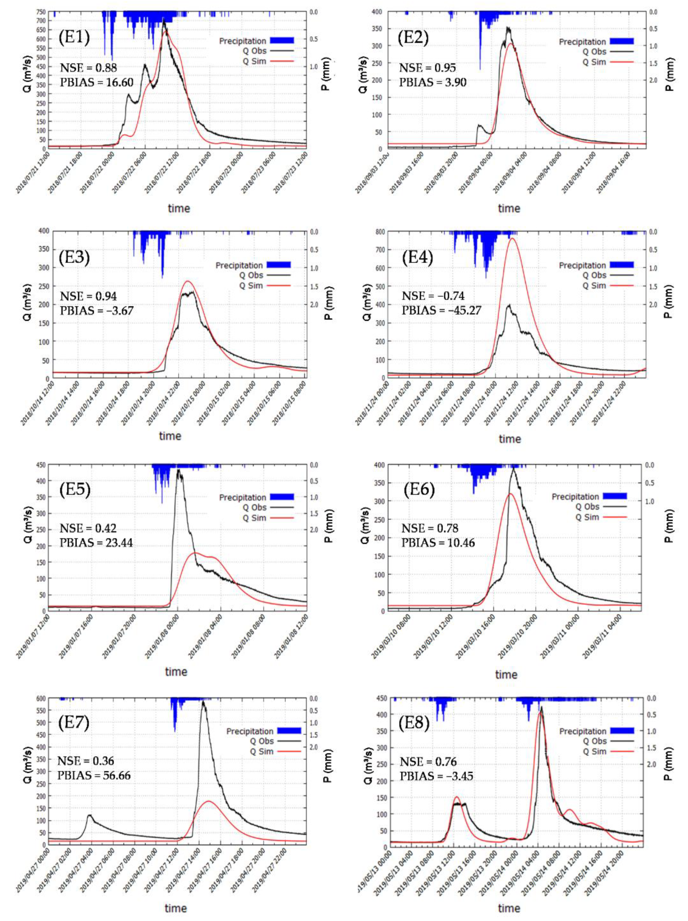
3.1. HEC-HMS Calibration
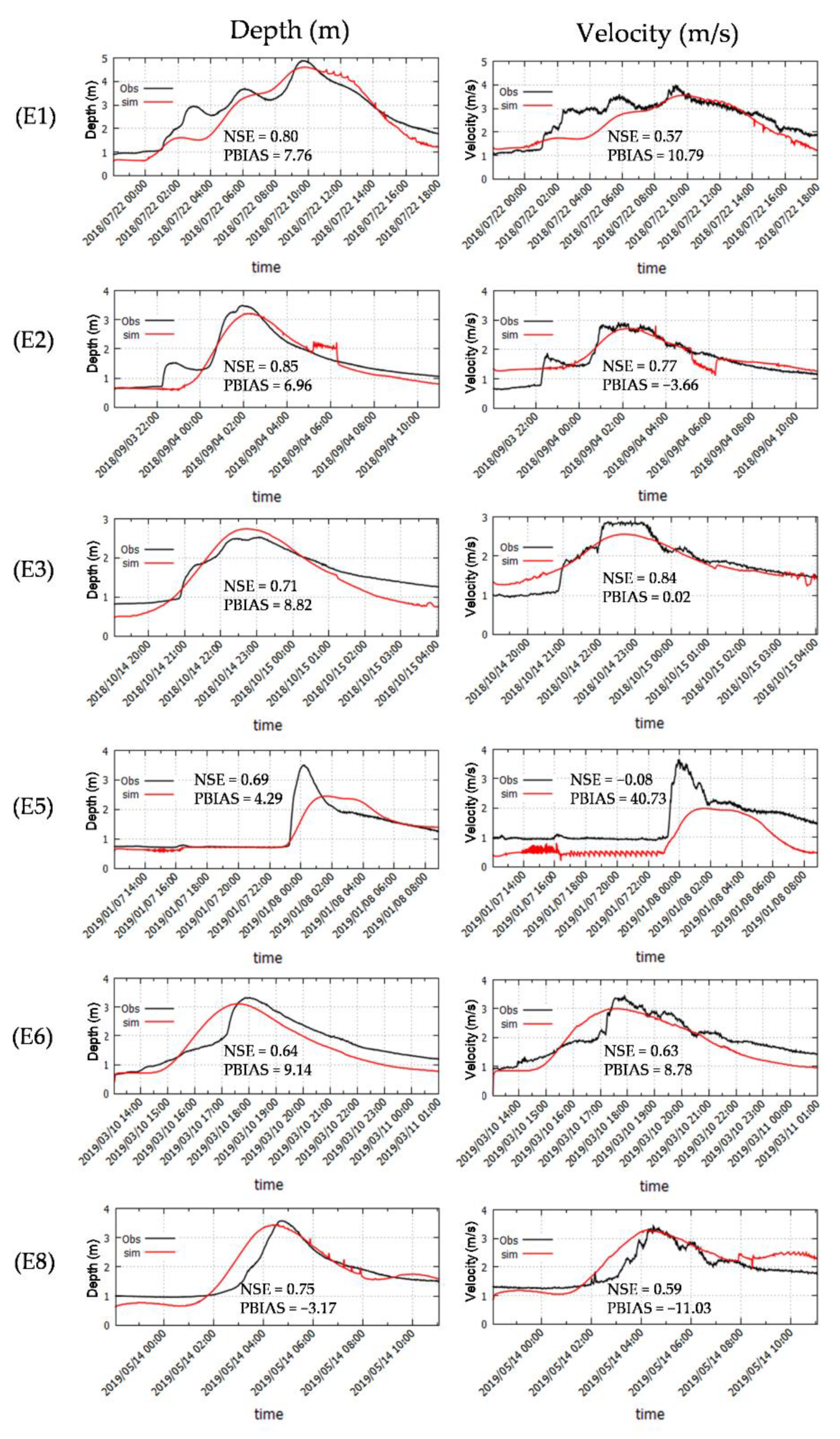
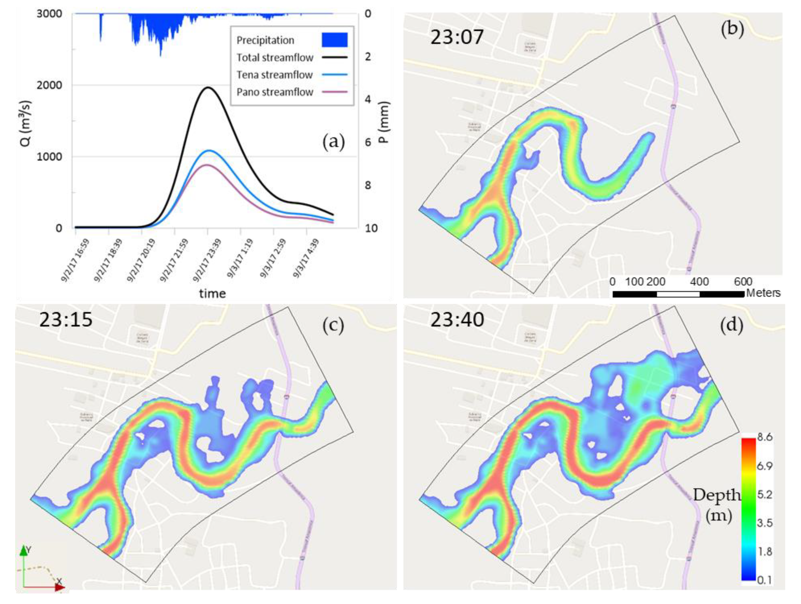
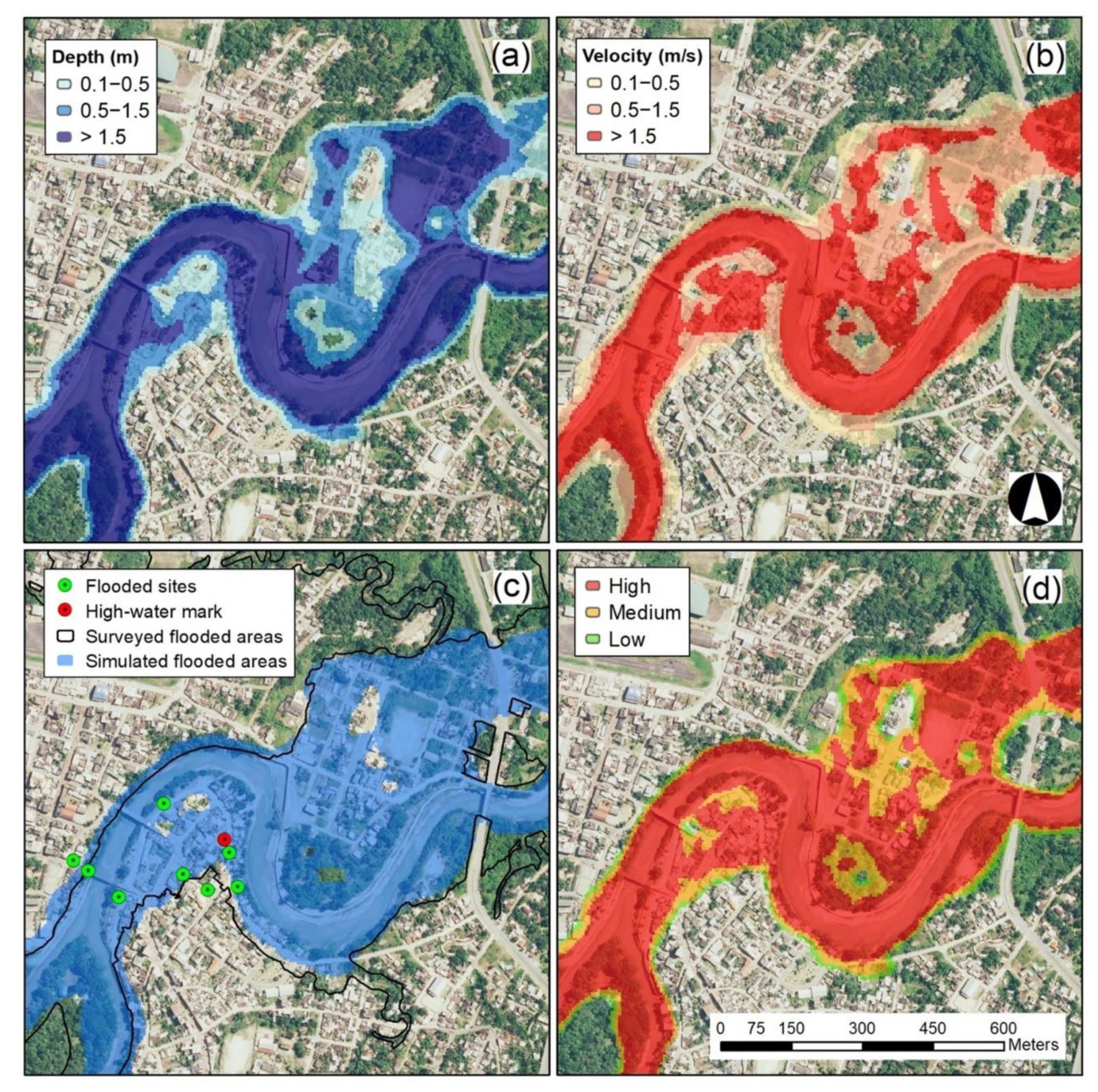
3.2. Nays2DFlood Calibration and Reconstruction of the 500-Year Flood Event
4. Conclusions
Author Contributions
Funding
Acknowledgments
Conflicts of Interest
References
- Jain, S.K.; Mani, P.; Jain, S.K.; Prakash, P.; Singh, V.P.; Tullos, D.; Kumar, S.; Agarwal, S.P.; Dimri, A.P. A Brief Review of Flood Forecasting Techniques and Their Applications. Int. J. River Basin Manag. 2018, 16, 329–344. [Google Scholar] [CrossRef]
- IPCC. AR5 Climate Change 2013: The Physical Science Basis—IPCC; Cambridge University Press: Cambridge, UK; New York, NY, USA, 2013; p. 1535. [Google Scholar]
- Merz, B.; Aerts, J.; Arnbjerg-Nielsen, K.; Baldi, M.; Becker, A.; Bichet, A.; Blöschl, G.; Bouwer, L.M.; Brauer, A.; Cioffi, F.; et al. Floods and Climate: Emerging Perspectives for Flood Risk Assessment and Management. Nat. Hazards Earth Syst. Sci. 2014, 14, 1921–1942. [Google Scholar] [CrossRef]
- Yin, J.; Gentine, P.; Zhou, S.; Sullivan, S.C.; Wang, R.; Zhang, Y.; Guo, S. Large Increase in Global Storm Runoff Extremes Driven by Climate and Anthropogenic Changes. Nat. Commun. 2018, 9, 4389. [Google Scholar] [CrossRef] [PubMed]
- Merkuryeva, G.; Merkuryev, Y.; Sokolov, B.V.; Potryasaev, S.; Zelentsov, V.A.; Lektauers, A. Advanced River Flood Monitoring, Modelling and Forecasting. J. Comput. Sci. 2015, 10, 77–85. [Google Scholar] [CrossRef]
- Díez-Herrero, A.; Huerta, L.L.; Isidro, M.L. A Handbook on Flood Hazard Mapping Methodologies; Geological Survey of Spain: Madrid, Spain, 2009. [Google Scholar]
- Bates, P.D.; De Roo, A.P.J. A Simple Raster-Based Model for Flood Inundation Simulation. J. Hydrol. 2000, 236, 54–77. [Google Scholar] [CrossRef]
- Shimizu, Y.; Inoue, T.; Suzuki, E.; Kawamura, S.; Iwasaki, T.; Hamaki, M.; Omura, K.; Kakegawa, E.; Yoshida, T. Nays2DFlood—Solver Manual; The International River Interface Cooperative (iRIC): Hokkaido, Japan, 2015; pp. 1–51. [Google Scholar]
- Bladé, E.; Cea, L.; Corestein, G.; Escolano, E.; Puertas, J.; Vázquez-Cendón, E.; Dolz, J.; Coll, A. Iber: Herramienta de Simulación Numérica Del Flujo En Ríos. Int. J. Numer. Methods Calc. Des. Eng. (RIMNI) 2014, 30, 1–10. [Google Scholar] [CrossRef]
- Fernández-Pato, J.; Caviedes-Voullième, D.; García-Navarro, P. Rainfall/Runoff Simulation with 2D Full Shallow Water Equations: Sensitivity Analysis and Calibration of Infiltration Parameters. J. Hydrol. 2016, 536, 496–513. [Google Scholar] [CrossRef]
- Smart, G.M. Improving Flood Hazard Prediction Models. Int. J. River Basin Manag. 2018, 16, 449–456. [Google Scholar] [CrossRef]
- Rai, P.K.; Dhanya, C.T.; Chahar, B.R. Coupling of 1D Models (SWAT and SWMM) with 2D Model (IRIC) for Mapping Inundation in Brahmani and Baitarani River Delta. Nat. Hazards 2018, 92, 1821–1840. [Google Scholar] [CrossRef]
- Hanif, A.; Dhanasekar, A.; Keene, A.; Li, H.; Carlson, K. Flood Risk Assessment Methodology for Planning under Climate Change Scenarios and the Corresponding Change in Land Cover. J. Water Clim. Chang. 2019. [Google Scholar] [CrossRef]
- Mishra, B.K.; Rafiei Emam, A.; Masago, Y.; Kumar, P.; Regmi, R.K.; Fukushi, K. Assessment of Future Flood Inundations under Climate and Land Use Change Scenarios in the Ciliwung River Basin, Jakarta. J. Flood Risk Manag. 2018, 11, S1105–S1115. [Google Scholar] [CrossRef]
- Liu, Z.; Zhang, H.; Liang, Q. A Coupled Hydrological and Hydrodynamic Model for Flood Simulation. Hydrol. Res. 2019, 50, 589–606. [Google Scholar] [CrossRef]
- Zhang, Y.; Zhou, J.; Lu, C. Integrated Hydrologic and Hydrodynamic Models to Improve Flood Simulation Capability in the Data-Scarce Three Gorges Reservoir Region. Water 2020, 12, 1462. [Google Scholar] [CrossRef]
- Chang, H.; Franczyk, J. Climate Change, Land-Use Change, and Floods: Toward an Integrated Assessment. Geogr. Compass 2008, 2, 1549–1579. [Google Scholar] [CrossRef]
- Barbedo, J.; Miguez, M.; van der Horst, D.; Marins, M. Enhancing Ecosystem Services for Flood Mitigation: A Conservation Strategy for Peri-Urban Landscapes? Ecol. Soc. 2014, 19, 54. [Google Scholar] [CrossRef]
- Tsakiris, G. Flood Risk Assessment: Concepts, Modelling, Applications. Nat. Hazards Earth Syst. Sci. 2014, 14, 1361–1369. [Google Scholar] [CrossRef]
- De Roo, A.; Schmuck, G.; Perdigao, V.; Thielen, J. The Influence of Historic Land Use Changes and Future Planned Land Use Scenarios on Floods in the Oder Catchment. Phys. Chem. Earth, Parts A/B/C 2003, 28, 1291–1300. [Google Scholar] [CrossRef]
- Moriasi, D.N.; Arnold, J.G.; Van Liew, M.W.; Bingner, R.L.; Harmel, R.D.; Veith, T.L.; Harmel, D.; Veith, T.L. Model Evaluation Guidelines for Systematic Quantification of Accuracy in Watershed Simulations. Trans. ASABE 2007, 50, 885–900. [Google Scholar] [CrossRef]
- Gupta, H.V.; Sorooshian, S.; Yapo, P.O. Status of Automatic Calibration for Hydrologic Models: Comparison with Multilevel Expert Calibration. J. Hydrol. Eng. 1999, 4, 135–143. [Google Scholar] [CrossRef]
- Teng, J.; Jakeman, A.J.J.; Vaze, J.; Croke, B.F.W.F.W.; Dutta, D.; Kim, S. Flood Inundation Modelling: A Review of Methods, Recent Advances and Uncertainty Analysis. Environ. Model. Softw. 2017, 90, 201–216. [Google Scholar] [CrossRef]
- Peña, F.; Nardi, F. Floodplain Terrain Analysis for Coarse Resolution 2D Flood Modeling. Hydrol. 2018, 5, 52. [Google Scholar] [CrossRef]
- Papaioannou, G.; Loukas, A.; Vasiliades, L.; Aronica, G.T. Flood Inundation Mapping Sensitivity to Riverine Spatial Resolution and Modelling Approach. Nat. Hazards 2016, 83, 117–132. [Google Scholar] [CrossRef]
- Caviedes-Voullième, D.; García-Navarro, P.; Murillo, J. Influence of Mesh Structure on 2D Full Shallow Water Equations and SCS Curve Number Simulation of Rainfall/Runoff Events. J. Hydrol. 2012, 448–449, 39–59. [Google Scholar] [CrossRef]
- Boongaling, C.G.K.; Faustino-Eslava, D.V.; Lansigan, F.P. Modeling Land Use Change Impacts on Hydrology and the Use of Landscape Metrics as Tools for Watershed Management: The Case of an Ungauged Catchment in the Philippines. Land Use Policy 2018, 72, 116–128. [Google Scholar] [CrossRef]
- Acero Triana, J.S.; Chu, M.L.; Guzman, J.A.; Moriasi, D.N.; Steiner, J.L. Beyond Model Metrics: The Perils of Calibrating Hydrologic Models. J. Hydrol. 2019, 578, 124032. [Google Scholar] [CrossRef]
- Johnston, R.; Smakhtin, V. Hydrological Modeling of Large River Basins: How Much Is Enough? Water Resour. Manag. 2014, 28, 2695–2730. [Google Scholar] [CrossRef]
- Reynolds, J.E.; Halldin, S.; Seibert, J.; Xu, C.Y.; Grabs, T. Robustness of Flood-Model Calibration Using Single and Multiple Events. Hydrol. Sci. J. 2019, 6667, 842–853. [Google Scholar] [CrossRef]
- McIntyre, N.; Lee, H.; Wheater, H.; Young, A.; Wagener, T. Ensemble Predictions of Runoff in Ungauged Catchments. Water Resour. Res. 2005, 41, 1–14. [Google Scholar] [CrossRef]
- Perrin, C.; Oudin, L.; Andreassian, V.; Rojas-Serna, C.; Michel, C.; Mathevet, T. Impact of Limited Streamflow Data on the Efficiency and the Parameters of Rainfall-Runoff Models. Hydrol. Sci. J. 2007, 52, 131–151. [Google Scholar] [CrossRef]
- Seibert, J.; McDonnell, J.J. Gauging the Ungauged Basin: Relative Value of Soft and Hard Data. J. Hydrol. Eng. 2015, 20, A4014004. [Google Scholar] [CrossRef]
- Correa, A.; Windhorst, D.; Crespo, P.; Célleri, R.; Feyen, J.; Breuer, L. Continuous versus Event-Based Sampling: How Many Samples Are Required for Deriving General Hydrological Understanding on Ecuador’s Páramo Region? Hydrol. Process. 2016, 30, 4059–4073. [Google Scholar] [CrossRef]
- Seibert, J.; Beven, K.J. Gauging the Ungauged Basin: How Many Discharge Measurements Are Needed? Hydrol. Earth Syst. Sci. 2009, 13, 883–892. [Google Scholar] [CrossRef]
- Juston, J.; Seibert, J.; Johansson, P.-O. Temporal Sampling Strategies and Uncertainty in Calibrating a Conceptual Hydrological Model for a Small Boreal Catchment. Hydrol. Process. 2009, 23, 3093–3109. [Google Scholar] [CrossRef]
- Espinoza, J.C.; Chavez, S.; Ronchail, J.; Junquas, C.; Takahashi, K.; Lavado, W. Rainfall Hotspots over the Southern Tropical Andes: Spatial Distribution, Rainfall Intensity, and Relations with Large-Scale Atmospheric Circulation. Water Resour. Res. 2015, 51, 3459–3475. [Google Scholar] [CrossRef]
- GAD-TENA. Actualización Plan de Desarrollo y Ordenamiento Territorial de Tena; Gobierno Municipal de Tena: Tena, Ecuador, 2014. [Google Scholar]
- Cruz-Cueva, G. Elaboración de Un Plan de Contingencia Por Inundación Del Río Tena En Los Barrios: Bellavista Las Hierbitas Tereré y Barrio Central de La Ciudad de Tena. PUCE: Quito, Ecuador, 2016. (In Spanish) [Google Scholar]
- Moreno, J.; Yerovi, F.; Herrera, M.; Yánez, D.; Espinosa, J.; Sánchez, D.; Merlo, J.; Haro, R.; Acosta, M.; Bernal, G. Soils from the Amazonia; Springer: Madison, WI, USA, 2018; pp. 79–111. [Google Scholar] [CrossRef]
- Tobón, C. Los Bosques Andinos y El Agua; ECOBONA: Quito, Ecuador, 2008. [Google Scholar]
- MAGAP-SIGTIERRAS. Generación de Geoinformación para la Gestión del Territorio a Nivel Nacional. Available online: metadatos.sigtierras.gob.ec (accessed on 12 July 2020). (In Spanish).
- Cadilhac, L.; Torres, R.; Calles, J.; Vanacker, V.; Calderón, E. Desafíos Para La Investigación Sobre El Cambio Climático En Ecuador. Neotrop. Biodivers. 2017, 3, 168–181. [Google Scholar] [CrossRef]
- INEC. Censo de Poblacion y Vivienda 2010. Available online: https://www.ecuadorencifras.gob.ec/estadisticas/ (accessed on 12 July 2020). (In Spanish).
- Palomino-Lemus, R.; Córdoba-Machado, S.; Gámiz-Fortis, S.R.; Castro-Díez, Y.; Esteban-Parra, M.J. Climate Change Projections of Boreal Summer Precipitation over Tropical America by Using Statistical Downscaling from CMIP5 Models. Environ. Res. Lett. 2017, 12, 124011. [Google Scholar] [CrossRef]
- Hirabayashi, Y.; Mahendran, R.; Koirala, S.; Konoshima, L.; Yamazaki, D.; Watanabe, S.; Kim, H.; Kanae, S. Global Flood Risk under Climate Change. Nat. Clim. Chang. 2013, 3, 816–821. [Google Scholar] [CrossRef]
- Sorribas, M.V.; Paiva, R.C.D.D.; Melack, J.M.; Bravo, J.M.; Jones, C.; Carvalho, L.; Beighley, E.; Forsberg, B.; Costa, M.H. Projections of Climate Change Effects on Discharge and Inundation in the Amazon Basin. Clim. Chang. 2016, 136, 555–570. [Google Scholar] [CrossRef]
- Armenta, E.; Villa, L.; Jácome, P. Proyecciones Climáticas De Precipitación Y Temperatura Para Ecuador, Bajo Distintos Escenarios De Cambio Climático.; Ministerio de Ambiente: Quito, Ecuador, 2016. (In Spanish) [Google Scholar]
- USGS. EarthExplorer. Available online: https://earthexplorer.usgs.gov/ (accessed on 6 June 2020).
- Sommer Messtechnick. RQ-30, RQ-30a, Discharge Measurement System User Manual.; Sommer GmbH: Koblach, Austria, 2014; Available online: https://www.sommer.at/en/products/water/rq-30-rq-30a (accessed on 12 July 2020).
- INAMHI. Determinación de Ecuaciones Para El Cálculo de Intensidades Máximas de Precipitación; Instituto Nacional de Meteorología e Hidrología (INAMHI): Quito, Ecuador, 2019; Available online: www.serviciometeorologico.gob.ec/Publicaciones/Hidrologia/ESTUDIO_DE_INTENSIDADES_V_FINAL.pdf (accessed on 12 July 2020). (In Spanish)
- Scharffenberg, B.; Bartles, M.; Braurer, T.; Fleming, M.; Karlovits, G. Hydrologic Modeling System HEC-HMS User’s Manual; No. 4.2; Hydrologic Engineering Center: Davis, CA, USA, 2016; Available online: https://www.hec.usace.army.mil/software/hec-hms/documentation/HEC-HMS_Users_Manual_4.2.pdf (accessed on 12 July 2020).
- Hawkins, R.H.; Ward, T.J.; Woodward, D.E.; Van Mullem, J.A. Curve Number Hydrology; American Society of Civil Engineers (ASCE): Reston, VA, USA, 2008. [Google Scholar]
- Cronshey, R. Urban Hydrology for Small Watersheds; U.S. Dept. of Agriculture Soil Conservation Service Engineering Division; United States Department of Agriculture (USDA): Washington, DC, USA, 1986. [Google Scholar]
- Merwade, V. Terrain Processing and HMS-Model Development Using GeoHMS Load the Data to ArcMap; Purdue University: West Lafayette, IN, USA, 2012; Available online: https://web.ics.purdue.edu/~vmerwade/education/geohms.pdf (accessed on 12 July 2020).
- Bondelid, T.R.; McCuen, R.H.; Jackson, T.J. Sensitivity of SCS Models to Curve Number Variation. J. Am. Water Resour. Assoc. 1982, 18, 111–116. [Google Scholar] [CrossRef]
- Fernandez Nualart, M.; Bateman Pinzon, A. Recuperación Paisajística y Estudio de Inundabilidad Del Sistema Hídrico a Su Paso Por Tena; Polytechnic University of Catalonia (UPC): Barcelona, Spain, 2004. (In Spanish) [Google Scholar]
- Vélez Upegui, J.J.; Botero Gutiérrez, A. Estimación Del Tiempo de Concentración y Tiempo de Rezago En La Cuenca Experimental Urbana de La Quebrada San Luis, Manizales. Dyna 2011, 165, 59. (In Spanish) [Google Scholar]
- Scharffenberg, W.A. Model Optimization. In Hydrologic Modeling System HEC-HMS, User Manual; US-Army-Corps-Engineers, Ed.; Hydrologic Engineering Center: Davis, CA, USA, 2016; pp. 383–419. [Google Scholar]
- Nash, J.E.; Sutcliffe, J.V. River Flow Forecasting through Conceptual Models Part I—A Discussion of Principles. J. Hydrol. 1970, 10, 282–290. [Google Scholar] [CrossRef]
- Shokory, J.A.N.; Tsutsumi, J.G.; Sakai, K. Flood Modeling and Simulation Using IRIC: A Case Study of Kabul City. E3S Web Conf. 2016, 7, 04003. [Google Scholar] [CrossRef]
- Kumar, S.; Kaushal, D.R.R.; Gosain, A.K.K. Hydrodynamic Simulation of Urban Stormwater Drain (Delhi City, India) Using IRIC Model. J. Appl. Res. Technol. 2018, 16, 67–78. [Google Scholar] [CrossRef]
- Chow, V. Hidráulica de Canales Abiertos; McGraw Hill: Bogotá, Colombia, 1994. (In Spanish) [Google Scholar]
- van der Sande, C.J.; de Jong, S.M.; de Roo, A.P.J. A Segmentation and Classification Approach of IKONOS-2 Imagery for Land Cover Mapping to Assist Flood Risk and Flood Damage Assessment. Int. J. Appl. Earth Obs. Geoinf. 2003, 4, 217–229. [Google Scholar] [CrossRef]
- Horritt, M.S.S.; Bates, P.D.D. Evaluation of 1D and 2D Numerical Models for Predicting River Flood Inundation. J. Hydrol. 2002, 268, 87–99. [Google Scholar] [CrossRef]
- Timbe, L.; Willems, P. Desempeño de Modelos Hidráulicos 1D y 2D Para La Simulación de Inundaciones. Maskana 2011, 2, 91–98. (In Spanish) [Google Scholar] [CrossRef]
- Domeneghetti, A.; Castellarin, A.; Tarpanelli, A.; Moramarco, T. Investigating the Uncertainty of Satellite Altimetry Products for Hydrodynamic Modelling. Hydrol. Process. 2015, 29, 4908–4918. [Google Scholar] [CrossRef]
- Ciervo, F.; Papa, M.N.; Medina, V.; Bateman, A. Simulation of Flash Floods in Ungauged Basins Using Post-Event Surveys and Numerical Modelling. J. Flood Risk Manag. 2015, 8, 343–355. [Google Scholar] [CrossRef]
- Mtamba, J.; van der Velde, R.; Ndomba, P.; Zoltán, V.; Mtalo, F. Use of Radarsat-2 and Landsat TM Images for Spatial Parameterization of Manning’s Roughness Coefficient in Hydraulic Modeling. Remote Sens. 2015, 7, 836–864. [Google Scholar] [CrossRef]
- Ponce, V.M. Kinematic Wave Controversy. J. Hydraul. Eng. 1991, 117, 511–525. [Google Scholar] [CrossRef]
- Barati, R.; Rahimi, S.; Akbari, G.H. Analysis of Dynamic Wave Model for Flood Routing in Natural Rivers. Water Sci. Eng. 2012, 5, 243–258. [Google Scholar] [CrossRef]
- Liu, Z.; Merwade, V.; Jafarzadegan, K. Investigating the Role of Model Structure and Surface Roughness in Generating Flood Inundation Extents Using One- and Two-Dimensional Hydraulic Models. J. Flood Risk Manag. 2019, 12, e12347. [Google Scholar] [CrossRef]
- Neto, A.; Batista, L.; Coutinho, R. Methodologies for Generation of Hazard Indicator Maps and Flood Prone Areas: Municipality of Ipojuca/PE. Rev. Bras. Recur. Hídricos 2016, 21, 377–390. [Google Scholar] [CrossRef]
- Courtel, F.; López, J.; Bello, M.; Noya, M. Mapas de Amenaza Por Inundaciones y Aludes Torrenciales En El Valle de Caracas. In Proceedings of the 32nd Congreso Latinoamericano De Hidráulica, Ciudad Guayana, Venezuela, 1−5 October 2006. (In Spanish). [Google Scholar]
- Cançado, V.; Brasil, L.; Nascimento, N.; Guerra, A. Flood Risk Assessment in an Urban Area: Measuring Hazard and Vulnerability. In Proceedings of the 11th International Conference on Urban Drainage, Edinburgh, Scotland, UK, 31 August–5 September 2008; IWA Publishing: Edinburgh, Scotland, UK, 2008; pp. 1–10. [Google Scholar]
- Da Silva, M.G.; De-Oliveira, A.; de Jesus Neves, R.J.; Nascimento, A.; Almeida, C.; Faccioli, G.G. Sensitivity Analysis and Calibration of Hydrological Modeling of the Watershed Northeast Brazil. J. Environ. Prot. 2015, 6, 837–850. [Google Scholar] [CrossRef]
- van Liew, M.W.; Arnold, J.G.; Bosch, D.D. Problems and Potential of Autocalibrating a Hydrologic Model. Trans. ASAE 2005, 48, 1025–1040. [Google Scholar] [CrossRef]
- Bin, L.; Xu, K.; Xu, X.; Lian, J.; Ma, C. Development of a Landscape Indicator to Evaluate the Effect of Landscape Pattern on Surface Runoff in the Haihe River Basin. J. Hydrol. 2018, 566, 546–557. [Google Scholar] [CrossRef]
- Asano, Y.; Uchida, T. The Roles of Channels and Hillslopes in Rainfall/Run-off Lag Times during Intense Storms in a Steep Catchment. Hydrol. Process. 2018, 32, 713–728. [Google Scholar] [CrossRef]
- Beven, K.; Binley, A. The Future of Distributed Models: Model Calibration and Uncertainty Prediction. Hydrol. Process. 1992, 6, 279–298. [Google Scholar] [CrossRef]
- Johnson, F.; White, C.J.; van Dijk, A.; Ekstrom, M.; Evans, J.P.; Jakob, D.; Kiem, A.S.; Leonard, M.; Rouillard, A.; Westra, S. Natural Hazards in Australia: Floods. Clim. Chang. 2016, 139, 21–35. [Google Scholar] [CrossRef]
- Iacob, O.; Brown, I.; Rowan, J. Natural Flood Management, Land Use and Climate Change Trade-Offs: The Case of Tarland Catchment, Scotland. Hydrol. Sci. J. 2017, 62, 1931–1948. [Google Scholar] [CrossRef]
- Bathurst, J.C.; Iroumé, A.; Cisneros, F.; Fallas, J.; Iturraspe, R.; Novillo, M.G.; Urciuolo, A.; de Bièvre, B.; Borges, V.G.; Coello, C.; et al. Forest Impact on Floods Due to Extreme Rainfall and Snowmelt in Four Latin American Environments 1: Field Data Analysis. J. Hydrol. 2011, 400, 281–291. [Google Scholar] [CrossRef]
- Dadson, S.J.; Hall, J.W.; Murgatroyd, A.; Acreman, M.; Bates, P.; Beven, K.; Heathwaite, L.; Holden, J.; Holman, I.P.; Lane, S.N.; et al. A Restatement of the Natural Science Evidence Concerning Catchment-Based ‘Natural’ Flood Management in the UK. Proc. R. Soc. A Math. Phys. Eng. Sci. 2017, 473, 20160706. [Google Scholar] [CrossRef]
- Hejl, H.; Kans, L. Roughness Coefficient for Flooded Urban Areas. J. Res. U.S. Geol. Surv. 1977, 5, 541–545. [Google Scholar]
- Mosquera-Machado, S.; Ahmad, S. Flood Hazard Assessment of Atrato River in Colombia. Water Resour. Manag. 2007, 21, 591–609. [Google Scholar] [CrossRef]
- Arcement, G.; Schneider, V. Guide for Selecting Manning’s Roughness Coefficients for Natural Channels and Flood Plains; United States Geological Survey (USGS): Denver, CO, USA, 1989.
- Xia, J.; Falconer, R.A.; Lin, B.; Tan, G. Numerical Assessment of Flood Hazard Risk to People and Vehicles in Flash Floods. Environ. Model. Softw. 2011, 26, 987–998. [Google Scholar] [CrossRef]
- Bocanegra, R.A.; Vallés-Morán, F.J.; Francés, F. Review and Analysis of Vehicle Stability Models during Floods and Proposal for Future Improvements. J. Flood Risk Manag. 2020, 13. [Google Scholar] [CrossRef]
- Huizinga, J.; de Moel, H.; Szewczyk, W. Glob. Flood Depth-Damage Functions: Methodology and the database with guidelines; Publications Office of the European Union: Luxemburg, 2017. [Google Scholar] [CrossRef]
- Servicio Nacional de Gestión de Riesgos y Emergencias (SNGRE). COE Cantonal Toma Resoluciones Ante emergencia en Tena. Boletín de Prensa. Available online: https://www.gestionderiesgos.gob.ec/coe-cantonal-toma-resoluciones-ante-emergencia-en-tena/ (accessed on 25 August 2020). (In Spanish).


| Parameter | Description [Units] | PRB | TRB |
|---|---|---|---|
| A | Drainage area [km2] | 99.96 | 134.86 |
| P | Perimeter [km] | 54.97 | 54.13 |
| El_min | Minimum elevation [m] | 499.00 | 499.00 |
| El_max | Maximum elevation [m] | 2494.00 | 2448.00 |
| El_ave | Mean elevation [m] | 982.00 | 1087.00 |
| Sl_min | Minimum slope [%] | 0.00 | 0.00 |
| Sl_max | Maximum slope [%] | 95.93 | 106.23 |
| Sl_ave | Mean slope [%] | 24.09 | 27.51 |
| Lh | Hydraulic length [km] | 25.43 | 27.99 |
| Le | Equivalent length [km] | 23.17 | 20.48 |
| Lr | Relative length of the largest reach (Lh / A^0.5) [-]; Lr > 1: elongated basin, Lr < 1: basins prone to floods | 2.54 | 2.41 |
| CN | Curve number for saturated conditions [-] | 90.00 | 87.00 |
| Tc | Time of concentration [minutes] | 180.00 | 190.00 |
| Lag | Lag time [minutes] | 108.00 | 114.00 |
| Bf | Baseflow [m3/s] | 6.00 | 9.00 |
| Event | Start (Date, Time) | End (Date, Time) | Duration (Hours) | Peak Flow (m3/s) |
|---|---|---|---|---|
| E1 | 21 July 2018, 12:00 | 23 July 2018, 12:00 | 48 | 714.20 |
| E2 | 03 September 2018, 12:00 | 04 September 2018, 18:00 | 30 | 356.00 |
| E3 | 14 October 2018, 12:00 | 15 October 2018, 08:00 | 20 | 234.80 |
| E4 | 24 November 2018, 00:00 | 24 November 2018, 24:00 | 24 | 403.30 |
| E5 | 07 January 2019, 12:00 | 08 January 2019, 12:00 | 24 | 435.60 |
| E6 | 10 March 2019, 06:00 | 11 March 2019, 06:00 | 24 | 395.60 |
| E7 | 27 April 2019, 00:00 | 27 April 2019, 24:00 | 24 | 589.80 |
| E8 | 13 May 2019, 00:00 | 14 May 2019, 24:00 | 48 | 424.40 |
| Flood Intensity | Depth (D) [m]-Velocity (V) [m/s] |
|---|---|
| High | D > 1.5 or V > 1.5 |
| Medium | 0.5 < D < 1.5 or 0.5 < V < 1.5 |
| Low | 0.1 < D < 0.5 and 0.1 < V < 0.5 |
| Event | Observed | Simulated | ||||
|---|---|---|---|---|---|---|
| Time at Peak (Time) | Peak Flow (m3/s) | Runoff Volume (mm) | Time at Peak (Time) | Peak Flow (m3/s) | Runoff Volume (mm) | |
| E1 | 09:24 | 714.20 | 100.66 | 09:47 | 641.10 | 83.96 |
| E2 | 01:49 | 356.00 | 25.34 | 02:16 | 306.30 | 24.52 |
| E3 | 23:09 | 234.80 | 16.92 | 22:42 | 263.70 | 17.54 |
| E4 | 11:19 | 403.30 | 30.25 | 11:33 | 760.80 | 43.94 |
| E5 | 00:09 | 435.60 | 24.1 | 01:36 | 178.10 | 18.45 |
| E6 | 17:54 | 395.60 | 25.21 | 17:36 | 319.90 | 22.57 |
| E7 | 14:24 | 589.80 | 33.76 | 14:53 | 178.10 | 14.63 |
| E8 | 04:40 | 424.40 | 48.01 | 04:24 | 404.60 | 49.67 |
© 2020 by the authors. Licensee MDPI, Basel, Switzerland. This article is an open access article distributed under the terms and conditions of the Creative Commons Attribution (CC BY) license (http://creativecommons.org/licenses/by/4.0/).
Share and Cite
Hurtado-Pidal, J.; Acero Triana, J.S.; Espitia-Sarmiento, E.; Jarrín-Pérez, F. Flood Hazard Assessment in Data-Scarce Watersheds Using Model Coupling, Event Sampling, and Survey Data. Water 2020, 12, 2768. https://doi.org/10.3390/w12102768
Hurtado-Pidal J, Acero Triana JS, Espitia-Sarmiento E, Jarrín-Pérez F. Flood Hazard Assessment in Data-Scarce Watersheds Using Model Coupling, Event Sampling, and Survey Data. Water. 2020; 12(10):2768. https://doi.org/10.3390/w12102768
Chicago/Turabian StyleHurtado-Pidal, Jorge, Juan S. Acero Triana, Edgar Espitia-Sarmiento, and Fernando Jarrín-Pérez. 2020. "Flood Hazard Assessment in Data-Scarce Watersheds Using Model Coupling, Event Sampling, and Survey Data" Water 12, no. 10: 2768. https://doi.org/10.3390/w12102768
APA StyleHurtado-Pidal, J., Acero Triana, J. S., Espitia-Sarmiento, E., & Jarrín-Pérez, F. (2020). Flood Hazard Assessment in Data-Scarce Watersheds Using Model Coupling, Event Sampling, and Survey Data. Water, 12(10), 2768. https://doi.org/10.3390/w12102768