Abstract
Hydrogeochemical processes and quality assessment for shallow groundwater are pivotal issues to be solved in many regions over the world due to the easy access of shallow groundwater. In this study, eighty-six water samples were collected from shallow aquifers of Chongqing, China, during July–September 2019. Multivariate statistical techniques, major ion ratios, and geochemical modeling were integrated to investigate hydrogeochemical characteristics and controlling factors. Afterwards, groundwater quality in spatial was classified by entropy-weighted water quality index and geographic information system (GIS) spatial analysis. Groundwater samples were alkaline and possessed high total dissolved solids (TDS) values. Two-group samples were distinguished as mix cations-HCO3-SO4 (group 1) and Ca-Mg-SO4 (group 2) facies. Hydrogeochemical compositions of group 1 samples were dominated by silicate dissolution and ion exchange, while sulfate and calcite dissolution were the main factors influencing the hydrogeochemical characteristics of group 2. The overall quality of groundwater samples varied greatly from excellent quality to extremely poor quality. Group 1 samples were found with excellent and good quality and suitable for drinking purposes. Group 2 samples were all unsuitable for direct drinking purposes as the quality varied from medium to extremely poor, but were spatially limited. Groundwaters with relatively poor quality were due to dissolution of sulfate that were locally enriched in the aquifers. The new findings of this study are expected to provide the reference for future management and sustainable exploitation of groundwater in Chongqing.
1. Introduction
Water is one of the most valuable but vulnerable natural resource in the world. With the explosive population increase and rapid industrial development, water resource has been significantly overexploited and polluted [1,2,3]. Of note, limited reserves and irregular distribution of surface water lead to it is not being available in many regions of the world, and thus groundwater would be the solely alternative for human society. Groundwater quality evaluation is the chief and urgent operation prior to utilization. Therefore, hydrogeochemical compositions of groundwater and their influencing factors are considered as the essential information for fully understanding groundwater quality and have been attracting massive attentions from ordinary people, academic fields, as well as government [4,5,6].
Hydrogeochemical compositions of groundwater are usually influenced by a combination of natural processes and anthropogenic activities. Natural processes consist of dissolution and precipitation of different minerals (e.g., calcite, dolomite, silicate, gypsum, halite, etc.) and corresponding ion exchange [7,8,9]. They are determined by flow path and aquifer affinity of the groundwater system. Anthropogenic activities are dominated by agricultural, industrial, domestic seepage, etc., producing abnormally high concentration of nitrogen, arsenic, and fluorine among others pollutants [10,11,12]. To understand hydrogeochemical compositions of groundwater, a series of methods have been adapted in recent decades. Hierarchical cluster analysis (HCA) and principal component analysis (PCA) are the representations of multivariate statistical approaches broadly carried out in the field of hydrogeochemical study [13,14,15]. They are feasible to classify a mass of hydrogeochemical data into different groups and efficiently extract principle components determining hydrogeochemical compositions. Major ion ratios have been widely used to distinguish the dissolution and precipitation of different minerals and identify the type of ion exchange [16,17,18]. Geochemical modeling is a feasible way to further constrain the status of minerals dissolution and precipitation in the groundwater system [19]. Afterwards, groundwater quality can be assessed using mathematical and geographic information system (GIS)-based spatial analysis, based on hydrogeochemical compositions of groundwater [20,21,22]. As shown above, numerous analytical methods have been employed for clarifying the hydrogeochemical process and quality evaluation of groundwater. However, how to achieve robust results by the integration of various methods has become a widespread and significant challenge.
Chongqing is one of the megacities in China and characterized as a developed industry and huge population. Hence, groundwater utilization is the key point for the sustainable development of Chongqing. Geothermal springs and karst landform have been characterized as the specific geological conditions in Chongqing. In recent decades, numerous studies have been carried out for the genesis of geothermal springs which exist as deep groundwater at the local scale [23,24,25,26,27,28]. In contrast, the hydrogeochemical process of shallow groundwater, especially at the regional scale, remains controversial and has yet to be further investigated. A few cases of shallow groundwater merely reserved in the karst aquifer were investigated though [29,30,31,32,33]. The imbalanced research for shallow groundwater seriously hampers the comprehensive exploitation of groundwater resource in Chongqing as well as other similar megacities all over the world.
Therefore, eighty-six groundwater samples were collected from monitoring wells for deep insight into the groundwater quality in the main urban area of Chongqing. This study is aimed to investigate the hydrogeochemical characteristic of shallow groundwater and corresponding controlling factors using the combination of multivariate statistical approaches, major ion ratios, and geochemical modeling, and then classify groundwater quality in spatial by entropy-weighted water quality index and GIS spatial analysis. The new findings of this research are expected to clarify the hydrogeochemical characteristics of shallow groundwater, which is favorable for future management and sustainable exploitation of shallow groundwater in the main urban area of Chongqing, southwestern China. Moreover, this study would provide the reference for the integration of various methods revealing the hydrogeochemical process and quality evaluation of groundwater.
2. Study Area
The study area is characterized as the main urban area situated in the western part of Chongqing in southwestern China (Figure 1a,b). The main urban area includes nine districts of 5473 km2, e.g., Yuzhong, Yubei, Jiangbei, Banan, and Beibei, etc. The geographic type belongs to middle-low mountain with the elevation of 155–1000 m. Chongqing has a typical subtropical humid climate with the annual average temperature of 18.6 °C and annual average precipitation of 1200 mm. Yangtze River traverses through the study area, fed by numerous rivers and streams. The population in the main urban area is about 8.75 million according to the Chinese statistics in 2018.
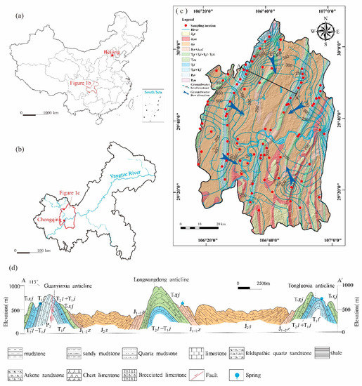
Figure 1.
(a) Location of Chongqing in China, (b) Location of the main urban area in Chongqing, (c) General geology and shaded relief map of the main urban area of Chongqing with groundwater sampling locations, (d) Geologic section of A-A’ showing alternative occurrence of anticlines and synclines within carbonate and clastic rocks.
Tectonically, Chongqing is located in the transitional area between the Tibetan Plateau and the middle-lower plains of the Yangtze River [34]. The structures in Chongqing are dominated by alternative occurrence of steep anticlines and broad synclines forming at Cretaceous, representing the distinguished pattern of the parallel mountain and valley (Figure 1c,d). The main strata exposed in Chongqing are Permian and Triassic carbonate (limestones and dolostones) and Triassic and Jurassic clastic rocks (sandstones and shales) [35,36]. Carbonate strata are generally developed in the core of anticlines and display developed karst caves and fractures, while clastic rocks are observed in the wings of anticlines where gypsum and coal are locally distributed (Figure 1c,d).
There are mainly two types of aquifers, i.e., carbonate aquifers and sandstone aquifers. Groundwater at the shallow depth is dominantly recharged by meteoric water with the elevation of 780–1160 m [29], and that at the deep depth is from the lateral and vertical recharge. The depth of the groundwater level varies from tens to hundreds of meters, resulting to nearly no evaporation for aquifers in the study area. Thus, water leaves the aquifers in many forms, including lateral and vertical discharge, as well as human exploitation. Shallow aquifers also interact with the Yangtze River all year round, and are recharged during the wet season and discharged in the dry season. The flow direction of groundwater is controlled by topography at the regional scale and karstic caves, fractures, fissures at the local scale. Overall, groundwater flows from the parallel mountains to lower parts of the valleys, and regionally from southwest to northeast in the study area. The carbonate aquifers have greater connectivity with the external and better permeability than the sandstone aquifers, thus, are more prone to the external pollutions from various sources, including agricultural practices, domestic lives, and industrial activities.
3. Materials and Methods
3.1. Groundwater Sampling and Analytical Techniques
In this study, eighty-six groundwater samples were collected from monitoring wells in Chongqing from July to September 2019. Sampling locations were recorded by a portable GPS device. Before sampling, every well was pumped for at least half an hour to eliminate the negative influence of static water. Sterilized plastic bottles were used to collect water samples. Bottles were rinsed 2–3 times with the sampling water before bottling. All water samples were instantly stored at 4 °C and sealed by watertight caps until analysis.
pH value and water temperature of groundwater samples were measured using a portable multi-meter device (WTW multi 3400i) at the site. Hydrogeochemical compositions were analyzed at the Laboratory of Chongqing Institute of Geology and Mineral Resources, Chongqing, China. Total dissolved solids (TDS) were determined by the oven drying method. Chemical oxygen demand (COD) and HCO3− were measured by the titrimetric method. The major cations K+, Na+, Ca2+, and Mg2+ were analyzed by inductively coupled plasma-optical emission spectrometry (ICP-OES) (Thermo Fisher ICAP-6300, Waltham, MA, USA) and the major anions (Cl−, SO42−, NO3− and F−) were determined by ion chromatograph (ICS-2500, Dionex, Sunnyvale, CA, USA). The calculated results of the charge balance errors showed that the uncertainty was less than ±10%, indicating an accepted accuracy of the measurements.
3.2. Multivariate Statistical Analysis
Considering large datasets for hydrogeochemical composition of groundwater, multivariate statistical analysis has been extensively employed to trace the real and valuable implications. In this study, hierarchical cluster analysis (HCA) and principal component analysis (PCA) were carried out to clarify hydrochemical types and probe the origin of chemical elements. The HCA and PCA were both operated by SPSS software (version 22).
In this study, HCA was carried out for physico-chemical parameters of groundwater samples. The Ward’s linkage method and the Euclidean distance were applied for sample grouping in HCA. Firstly, most similar groundwater samples were grouped as a cluster. Then, different clusters were combined based on Ward linkage theory, and thus all groundwater samples were grouped. Finally, a dendrogram was produced, resulting from the HCA and several present clusters. Therefore, groundwater samples with similar physico-chemical parameters would be classified into several groups by average linkage distance among clusters.
The PCA is an efficient way to recognize the majority of variance by reducing dimensions of chemical variables. Prior to the PCA, all parameter should be normalized by z-score transformation because they possess different dimensions and units. Chemical variables will be characterized by different loadings in the PCA. Principle components having appropriate eigenvalues (higher than 1) are permissible to be analyzed as Kaiser suggested [37]. The factors produced from the PCA represent the possible sources of hydrochemical compositions of groundwater.
3.3. Geochemical Modeling
Mineral equilibrium is the performance for thermodynamic processes in groundwater systems. Saturation indice (SI) is available to investigate the status of minerals in groundwater. Hence, the SI values are feasible to estimate the mineral phase in the groundwater system, which are fundamental for understanding minerals’ dissolution and precipitation. In this study, the PHREEQC software was used to calculate the SI values based on the equation below [38]:
SI = log (IAP)/K.
In Equation (1), IAP = ion activity products, K= corresponding equilibrium constant, SI = 0, SI > 0, and SI < 0 represent equilibrium, oversaturation, and undersaturation, respectively.
3.4. Entropy-Weighted Water Quality Index (EWQI)
The entropy-weighted water quality index (EWQI) is one of the excellent comprehensive water quality assessment approaches, applying the information entropy in the hydrochemical indicators’ weight determination of water quality index (WQI). The introduction of entropy-weight can avoid the man-made deviations/mistakes for the weight of hydrochemical indicators that may influence the assessment credibility.
Generally, there are four steps for the procedure of the EWQI assessment (Figure 2). Before the start of EWQI assessment, water quality data should be collected and the hydrochemcial parameters used in the assessment also should be determined based on the comprehensive understanding of the hydrochemical environment.
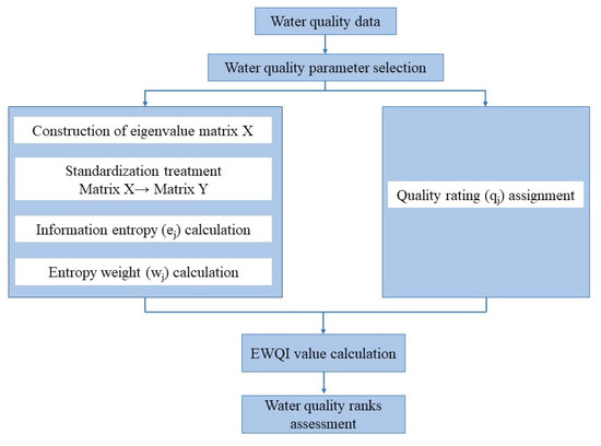
Figure 2.
The overall flow framework of the Entropy-Weighted Water Quality Index (EWQI).
(1) The first main step of the EWQI assessment is to obtain the entropy weight of each hydrochemical parameter for all samples.
Firstly, the eigenvalue matrix X should be constructed as following Equation (2):
where m signifies the number of water samples, and n represents the total number of hydrochemical indices of each water sample.
As differences of hydrochemical parameters may exist regarding the units and quantity grades, the data of all parameters should be standardized. This could be achieved with the aid of the Equation (3). The parameters may be classified into two types, namely benefit type and cost type according to their attribution and contribution [39]:
where (xij)max and (xij)min are the maximum and minimum values of the hydrochemical parameters of the water samples, respectively.
After the pretreatments, the standard matrix can be constructed as following Equation (4):
Then, the entropy “ej” was calculated by the following Equation (5):
where the Pij is parameter value ratio of the parameter j for sample i, and is expressed by the Equation (6) below:
At last, the entropy weight “wj” can be calculated as below:
(2) The second main step of the EWQI assessment is to calculate the quality rating scale “qj” of each parameter. The “qj” could be computed by the following Equation (8):
where Cj is the concentration of hydrochemical indicator j; Sj is the permissible limit of national standards or World Health Organization standards for a specific hydrochemical indicator j.
(3) The third step is to compute the EWQI value using the following Formula (9):
(4) The final step is to category the water quality ranks based on the EWQI.
According to the classification criteria of EWQI values, water quality can be generally categorized into five ranks (Table 1). Groundwater quality is regarded as excellent (Rank 1) if the EWQI values are below 50, or good (Rank 2) when EWQI values range from 50 to 100. If the EWQI values are in the range of 100–150, 150–200, and exceeding 200, respectively, groundwater would be identified as medium (Rank 3), poor (Rank 4), and extremely poor (Rank 5) quality, respectively.

Table 1.
Classification criteria of water quality base on the EWQI.
4. Results and Discussion
4.1. Statistical Results of Hydrochemical Parameters
The experimental data set of groundwater samples collected from the study area was given in Supplementary Materials Table S1. To better visualize the vast data set, statistical analysis was conducted in this study. The statistical results of maximum, minimum, mean, standard deviation, median were presented in Table 2, while the corresponding Box and Whisker plot was shown in Figure 3. The pH values varied from 6.7 to 8.6 with the mean value of 7.6, indicating weakly alkaline affinity. The COD and TDS values had a range of 0.15–24.21 mg/L and 143.90–2761.92 mg/L, respectively. It is noteworthy that the TDS values displayed high dispersion with the standard deviation of 364.83 mg/L, which is likely attributed to multiple factors (e.g., aquifer heterogeneity and anthropogenic activities). Meanwhile, the TDS values largely exceeded the permissible limit (1000 mg/L) for the drinking-water standard proposed from the World Health Organization (WHO) [40]. The average concentrations of cations and anions followed the order as Ca2+ > Na+ > Mg2+ > K+ and HCO3– > SO42− > Cl− > NO3− > F−. Herein, Ca2+ (5.01–564.41 mg/L) and HCO3− (75.07–559.37 mg/L) were the dominated cation and anion in the groundwater system of the study area.

Table 2.
Statistical summary of chemical parameters of groundwater samples.
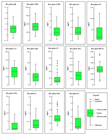
Figure 3.
Box and Whisker plot of chemical parameters of groundwater samples.
4.2. Hydrochemical Type
In this study, Q-mode HCA was applied for the group of groundwater samples. The results showed the eighty-six groundwater samples were gathered into two groups (named group 1 and group 2) prior to the linkage distance of 25 (dendrogram as shown in Supplementary Figure S1), accounting for 93% and 7% of all groundwater samples. Meanwhile, the Stiff diagram was drawn for mean concentrations of group 1 and group 2 in Supplementary Figure S1. Hydrochemical types of group 1 and group 2 were obviously recognizable, indicating the desirable results of Q-mode HCA. According to the Stiff diagram, group 1 samples were characterized by mixed cations of Na+ and Ca2+ and primary anion of HCO3−, while group 2 samples were dominated by Ca2+ and SO42−. In addition, the TDS values of group 2 samples (average = 1459.44 mg/L) were much higher than those of group 1 (average = 499.15 mg/L) (Supplementary Table S1), indicating these two groups of groundwater samples experienced different hydrogeochemical evolution. It is noteworthy that high mineralization was identified in group 2, implying the potential influence of localized geological environment or anthropogenic activities.
Piper trilinear diagram has been extensively used to further constrain hydrochemical types. In this study, all the eighty-six groundwater samples had similar cations but distinguishable anions. For cation contents, most samples displayed the predominant cation of Ca2+. Group 1 and 2 samples identified by Q-mode HCA revealed low and high SO42− concentrations in Figure 4, respectively. The anomaly of SO42− concentration was possiblely attributed to sulfate dissolution and anthropogenic impacts.
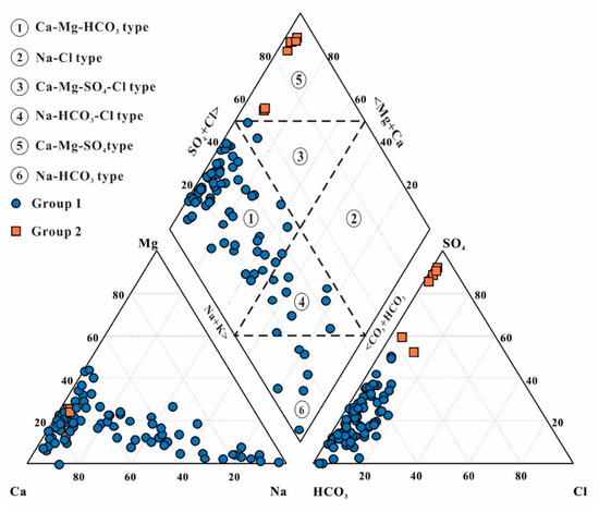
Figure 4.
Piper trilinear diagram for groundwater samples.
4.3. Mechanism Controlling Groundwater Hydrogeochemistry
4.3.1. Principal Component Analysis
Principal component analysis was conducted based on twelve hydrogeochemical variables (pH, COD, TDS, Ca, Mg, Na, K, HCO3, SO4, Cl, NO3, F, and Sr) in this study. The Kaiser–Meyer–Olkin testing index was 0.67 (~0.70), satisfying the analytical request of principal component analysis. Due to the different units of hydrogeochemical variables, log-normalization was employed prior to principal component analysis. Afterwards, four principal components (PCs) with eigenvalue larger than 1 were extracted, and accounted for 66.38% of total variance as shown in Table 3. The PC1 was responsible for 28.76% of total variance and had a strong loading of TDS, K, Ca, Mg, SO4, and F. The PC2 explained 18.39% of total variance and has strong loading of Na, Cl, and SiO2. Both PC1 and PC2 were characterized as the “geogenic” compositions determining by hydrogeochemical process related to mineral dissolutions and precipitation. PC3 can be interpreted as the “alkaline environment” component due to the negative correlation between pH and HCO3. PC4 is defined as the “anthropogenic” component related to human activities (e.g., industrial, agricultural, domestic sewage, etc.), determining the variation of nitrate content, due to its strong positive loading on NO3. Factors responsible for these high loadings will be discussed in latter sections

Table 3.
Principal component loadings and explained variance for the three components.
4.3.2. Gibbs Diagram
Gibbs diagram has been broadly used to distinguish the major factors controlling the hydrogeochemical compositions [7]. Gibbs (1970) proposed that rock weathering, atmospheric precipitation, and evaporation as three natural fundamental processes mainly determining hydrogeochemical compositions. In this study, the Na+/(Na+ + Ca2+) and Cl−/(Cl− + HCO3−) cation weight ratios of group 1 and 2 were consistent, varying from 0.01 to 0.97 and from 0.01 to 026, respectively. Groundwater samples were mostly plotted in the middle part of the Gibbs diagram (Figure 5). Hence, the hydrogeochemical compositions of groundwater samples were mainly derived from rock–water interaction in this study. In addition, Na+/(Na+ + Ca2+) cation weight ratios of group 1 performed an increasing trend in Figure 5a, implying cation exchange also had a relevant effect on hydrogeochemical compositions.
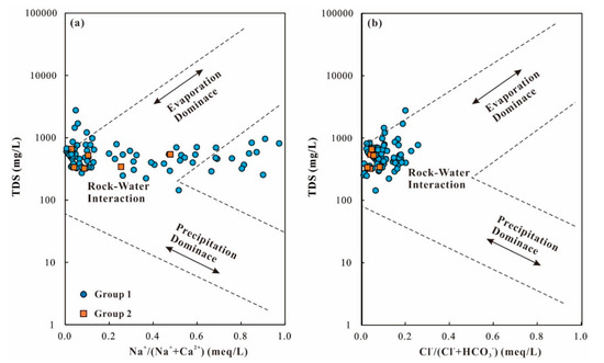
Figure 5.
Gibbs diagrams for groundwater samples, (a) Na+/(Na+ + Ca2+) vs. total dissolved solids (TDS), (b) Cl−/(Cl− + HCO3−) vs. total dissolved solids (TDS).
4.3.3. Hydrogeochemical Process
As revealed above by Gibbs diagrams, rock–water interaction is the dominated factor controlling hydrogeochemical compositions of groundwater in the study area. Correlation of major ions is believable to clarify the types of rock–water interaction in groundwater circulation [41]. The Na+/Cl− molar ratio would be equal to 1 if halite dissolution is the dominant process contributing groundwater hydrochemistry (Equation (10)). However, the Na+/Cl− molar ratios were higher than 1 in this study (Figure 6a). The excess Na+ should be attributed to albite weathering and cation exchange:
NaCl → Na+ + Cl−.
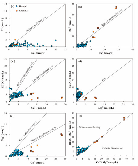
Figure 6.
Relationships between major ion concentrations of groundwater samples, (a) Cl− vs. Na+, (b) SO42− vs Ca2+, (c) HCO3− vs. Ca2+, (d) HCO3− vs. Mg2+, (e) Mg2+ vs. Ca2+, and (f) HCO3− + SO42− vs. Ca2+ + Mg2+.
The Ca2+/SO42− ratio equal to 1 is due to gypsum dissolution (Equation (11)). In this study, the majority of group 1 samples possessed excess Ca2+ which would be originated from dissolution of anorthite or carbonate. Only a few groundwater samples of the group 2 plot along or slightly deviated from the 1:1 equiline (Figure 6b), revealing the dominance of gypsum dissolution. Of note, two samples of group 2 displayed obviously high contents of SO42−, implying the extra influence of anthropogenic activity or sulfide oxidation:
CaSO4·2H2O ⇄ Ca2+ + SO42− + 2H2O.
The Ca2+/HCO3− ratio can be used to further investigate carbonate dissolution (calcite = 1:1, dolomite = 1:2) (Equations (12) and (13)). In Figure 6c, most groundwater samples of group 1 were sandwiched between 1:1 and 1:2 equilines, indicating carbonate dissolution. Group 2 samples were far deviated from 1:1 and 1:2 equilines and had excess Ca2+, suggesting other source for Ca2+:
CaCO3 (calcite) + H2CO3 → Ca2+ + 2HCO3−,
CaMg(CO3)2 (dolomite) + 2H2CO3 → Ca2+ + Mg2+ + 4HCO3−.
In Figure 6d, most groundwater samples were located above the 1:1 equiline, indicating excess HCO3− was balanced out by other ions. The Ca2+/Mg2+ ratio is usually used to distinguish the ions source between carbonate and silicate dissolution. Dolomite dissolution would lead to the Ca2+/Mg2+ ratio equal to one, while calcite dissolution may produce the Ca2+/Mg2+ ratio higher than one (Equations (12) and (13)). Besides, the Ca2+/Mg2+ ratio higher than 2 is the result from silicate dissolution. In this study, groundwater samples of group 1 were higher than 1, and most of them plotted close to the 2:1 equiline (Figure 6e), demonstrating the hydrogeochemical compositions of group 1 were mainly from dissolution of silicate and calcite. Groundwater samples of group 2 were far away from the 2:1 equiline, illustrating the predominated source from silicate and calcite dissolutions.
The bivariate diagram of (Ca2+ + Mg2+) and (HCO3− + SO42−) is believable to clarify the ion exchange and reverse ion exchange. The plots above the 1:1 line suggested ion exchange (Equation (14)) was the dominant process, while the plots below the 1:1 line indicated existence of the reverse ion exchange process (Equation (15)). It is noted that “X” is the mark of clay and minerals (montmorillonite, vermiculite, zeolite, and etc.). When the (Ca2+ + Mg2+)/(HCO3− + SO42−) ratio is 1:1, the hydrogeochemical compositions of groundwater is originated from dissolution of carbonates and sulfate minerals. Figure 6f showed that most samples of group 1 are above and along the 1:1 equiline, depicting silicate dissolution is the major geochemical process responsible for the increased HCO3– and SO42− concentration in groundwater. The plots of group 2 along the 1:1 equiline contended the dissolution of carbonates and sulfate minerals:
Ion exchange: 2NaX + Ca2+ → 2Na+ + CaX2,
Reverse ion exchange: CaX2 + 2Na+ → Ca2+ + 2NaX.
The relationship between (Na+ + K+ − Cl−) and [(Ca2+ + Mg2+) − (HCO3− + SO42−)] is used to assure the occurrence of cation exchange. When groundwater chemical compositions are dominated by cation exchange, the correlation parameter of (Na+ + K+ − Cl−) and [(Ca2+ + Mg2+) − (HCO3− + SO42−)] would be equal to −1. It is noteworthy that group 1 samples were almost along the straight line with a slope of −1, whereas group 2 samples were significantly deviated that line (Figure 7a). In addition, the Schoeller indices (CAI-I and CAI-II) are feasible to recognize cation exchange process in groundwater (Equations (16) and (17)). When CAI-I and CAI-II values are lower than 0, cation exchange process is proposed. In contrast, reverse cation exchange is verified by positive CAI-I and CAI-II values. In this study, CAI values of group 1 samples were lower than 0, whereas those of group 2 samples were higher than 0 (Figure 7b). Therefore, it was demonstrated that cation exchange exists in group 1 rather than group 2:
CAI-I = (Cl− − (Na+ + K+))/Cl−,
CAI-II = (Cl− − (Na+ + K+))/(HCO3− + SO42− + CO32− + NO3−).
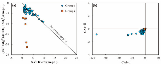
Figure 7.
Plots showing (a) (Na+ + K+ − Cl−) vs. (Ca2+ + Mg2+ − HCO3− − SO42−), (b) CAI-I vs. CAI-II for groundwater samples (CAI-I and CAI-II are calculated in meq/L).
In summary, the hydrogeochemical compositions of group 1 samples were dominated by silicate dissolution and ion exchange, partially involved with calcite and sulfate dissolution. Sulfate and calcite dissolution were the main factors affecting the hydrogeochemical characteristics of group 2. In addition, the dissolutions of fluorite (CaF2) and strontianite (SrCO3) and NO3− released by human activity make minor contribution to hydrogeochenmical compositions in the study area.
4.3.4. Saturation Indices
Saturation indices (SI) achieved by the PHREEQC software were adapted to investigate the patterns of minerals’ dissolution and precipitation. The SI values against TDS values of two group samples are shown in Figure 8. The SI values of aragonite, calcite, and dolomite were mostly higher than 0 (Figure 8a–c), indicating the oversaturation of carbonate minerals. But their SI values did not present the liner trend with TDS values, possibly affected by the partial pressure of CO2. On the other hand, gypsum, anhydrite, halite, fluorite, and strontianite displayed negative SI values (Figure 8d–h), which reached unsaturated status in the groundwater system. SI values of quartz were close to 0, indicating relatively equilibrium status (Figure 8i).
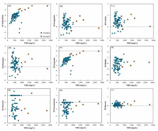
Figure 8.
Scatterplots of saturation indices of (a) anhydrite, (b) aragonite, (c) calcite, (d) dolomite, (e) gypsum, (f) halite, (g) fluorite, (h) strontianite, and (i) quartz vs. total dissolved solids (TDS) for groundwater samples.
Of note, the SI values of gypsum and anhydrite had the negative relationship with corresponding TDS values for groundwater samples in group 2. Moreover, group 2 had the larger range of SI values of gypsum (−0.91 to –4.74) and anhydrite (−1.21 to −5.04) than those of group 1 (gypsum: −0.02 to −0.71; anhydrite: −0.33 to −1.01). Therefore, gypsum and anhydrite dissolutions played a more vital role in the hydrogeochemical process in group 2 rather than group 1.
4.4. Groundwater Quality Classification and Its Spatial Distribution
The entropy-weighted water quality index (EWQI) approach has been introduced in the present study to reveal the overall quality of groundwater. A total of twelve indices including pH, COD, TDS, Ca2+, Mg2+, Na+, K+, HCO3−, SO42−, Cl− and NO3−, F− were taken into account when the EWQI assessment was applied in the present study. According to the assessment results, the EWQI values of the groundwater samples in the study area ranged from 11 to 279, suggesting groundwater quality varied from excellent (rank 1) to extremely poor (rank 5). About 93.0% of groundwater samples were found with the EWQI value below 100, demonstrating most of groundwater samples in the study area belonged to the quality categories of rank 1 (excellent quality) and rank 2 (good quality). Approximately 4.7% of groundwater samples (four samples) had the EWQI value ranging from 100 to 150, implying water quality of rank 3 (medium quality). The other 2.3% of groundwater samples (two samples) were with the EWQI value above 200, suggesting water quality of rank 5 (extremely poor quality).
Generally, water with the EWQI value less than 100 is suitable for drinking purposes, and that exceeding 100 should be avoided to serve as domestic water directly [42]. Thus, most of the groundwater samples in the study area were suitable for drinking purposes, and only six groundwater samples (7% of the total groundwater samples) were unsuitable for domestic use. As shown in Figure 9, all groundwater samples of group 1 that obtained by Q-mode HCA were observed plotting in the rank 1 and rank 2 categories, implying excellent to good water quality. Groundwater samples of group 2 were all found with the EWQI values exceeding 100, suggesting medium (rank 3) to extremely poor (rank 5) water quality. As discussed before, the chemical components of groundwater samples in group 2 were dominantly controlled by the dissolution of sulfate and calcite and resulted in saltier water hydrochemical type of Ca-Mg-SO4. This means that the relatively poor quality of groundwater in the study area was mainly caused by local natural water–rock interaction such as sulfate dissolution due to the heterogeneity of aquifers lithology. Both concentrations of F− and NO3− are lower than the pollution standard of WHO (2011) [40], excluding the possibility of groundwater pollution from anthropogenic activity.
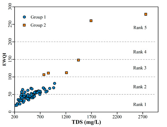
Figure 9.
The relationship between the entropy-weighted water quality index (EWQI) and TDS.
The spatial distribution of water quality based on the EWQI classification was portrayed in Figure 10. It can be clearly seen that the groundwater samples in most of the study area are with the quality classified as rank 1 and rank 2, suggesting they display excellent and good quality and are suitable for drinking purposes. Two concentrated areas of the eastern and southern study area and three sporadic areas in the north and west were found with the groundwater quality categorized into rank 3 to rank 5, implying medium to extremely poor quality for drinking purposes and unsuitable for drinking purposes. Although these groundwater samples were very limited spatially, measures should also be taken in these areas to guarantee the safety of water supply when exploiting local groundwater for domestic usages. But measures should be taken in these areas to guarantee the safety of the water supply when exploiting local groundwater for domestic usages.
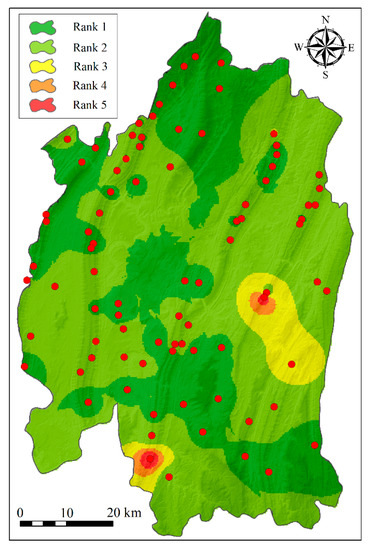
Figure 10.
The spatial distribution of groundwater quality based on the EWQI rank.
5. Conclusions
In this study, multivariate statistical techniques, major ion ratios, and geochemical modeling were coupled to investigate hydrogeochemical characteristics of shallow groundwater and corresponding controlling factors in the main urban area of Chongqing, southwestern China. Several conclusions have been achieved as the following:
(1) Groundwater samples represented alkaline affinity and high TDS values. The cation and anion were dominated by Ca2+ and HCO3−, respectively. Two distinguished hydrochemical types were recognized as mix cations-HCO3-SO4 (group 1) and Ca-Mg-SO4 (group 2) hydrochemical facies based on the Piper diagram and hierarchical cluster analysis.
(2) Principal component analysis and Gibbs diagram collectively indicated hydrogeochemical compositions of groundwater are determined by water–rock interaction. Correlation of major ions and saturation indices further proposed: hydrogeochemical compositions of group 1 samples were dominated by silicate dissolution and ion exchange, while sulfate and calcite dissolution were the main factors affecting the hydrogeochemical characteristics of group 2. The dissolutions of fluorite (CaF2) and strontianite (SrCO3) and NO3− released by human activity make a minor contribution to hydrogeochenmical compositions in the study area.
(3) According to the EWQI assessment, the overall quality of groundwater samples in the study area varied greatly from excellent quality to extremely poor quality. All groundwater samples in group 1 were found with excellent and good quality and widespread over the study area, and suitable for the drinking purposes. Groundwater samples in group 2 were all unsuitable for direct drinking purposes as the quality varying from medium to extremely poor, due to natural dissolution of locally sulfate minerals.
Supplementary Materials
The following are available online at https://www.mdpi.com/2073-4441/12/10/2833/s1, Figure S1: Dendrogram for the groundwater samples, showing the two groups and the mean concentration Stiff diagram of each group, Table S1: Experimental data for groundwater samples in main urban area of Chongqing, Table S2: Saturation indices of groundwater samples in main urban area of Chongqing.
Author Contributions
Conceptualization, Z.T.; Data curation, J.W. (Jian Wang); Formal analysis, J.W. (Jialing Wu); Funding acquisition, S.C.; Investigation, C.Y.; Software, W.K.; Writing—original draft, S.C.; Writing—review & editing, Z.T. and X.H. All authors have read and agreed to the published version of the manuscript.
Funding
This research was funded by the projects “Construction of groundwater monitoring station network in Chongqing (2018–2020) Monitoring well construction” and “Construction of groundwater monitoring system for the ecological Protection and restoration project of mountains, rivers, forests, fields, lakes and grass in the Upper Reaches of the Yangtze River (Chongqing section) (Phase I and Phase II)”.
Acknowledgments
Authors are grateful to the Editor and anonymous reviewers whose insightful comments were very helpful in improving the paper.
Conflicts of Interest
The authors declare no conflict of interest.
References
- Gu, X.; Xiao, Y.; Yin, S.; Hao, Q.; Liu, H.; Hao, Z.; Meng, G.; Pei, Q.; Yan, H. Hydrogeochemical Characterization and Quality Assessment of Groundwater in a Long-Term Reclaimed Water Irrigation Area, North China Plain. Water 2018, 10, 1209. [Google Scholar] [CrossRef]
- Xiao, Y.; Gu, X.; Yin, S.; Pan, X.; Shao, J.; Cui, Y. Investigation of Geochemical Characteristics and Controlling Processes of Groundwater in a Typical Long-Term Reclaimed Water Use Area. Water 2017, 9, 800. [Google Scholar] [CrossRef]
- Xiong, G.-Y.; Chen, G.-Q.; Xu, X.-Y.; Liu, W.-Q.; Fu, T.-F.; Khokiattiwong, S.; Kornkanitnan, N.; Ali Seddique, A.; Shi, X.-F.; Liu, S.-F.; et al. A comparative study on hydrochemical evolution and quality of groundwater in coastal areas of Thailand and Bangladesh. J. Asian Earth Sci. 2020, 195, 104336. [Google Scholar] [CrossRef]
- Stopelli, E.; Duyen, V.T.; Mai, T.T.; Trang, P.T.K.; Viet, P.H.; Lightfoot, A.; Kipfer, R.; Schneider, M.; Eiche, E.; Kontny, A.; et al. Spatial and temporal evolution of groundwater arsenic contamination in the Red River delta, Vietnam: Interplay of mobilisation and retardation processes. Sci. Total Environ. 2020, 717, 137143. [Google Scholar] [CrossRef]
- Liu, F.; Zhao, Z.; Yang, L.; Ma, Y.; Xu, Y.; Gong, L.; Liu, H. Geochemical characterization of shallow groundwater using multivariate statistical analysis and geochemical modeling in an irrigated region along the upper Yellow River, Northwestern China. J. Geochem. Explor. 2020, 215, 106565. [Google Scholar] [CrossRef]
- Liu, F.; Wang, S.; Yeh, T.-C.J.; Zhen, P.; Wang, L.; Shi, L. Using multivariate statistical techniques and geochemical modelling to identify factors controlling the evolution of groundwater chemistry in a typical transitional area between Taihang Mountains and North China Plain. Hydrol. Process. 2020, 34, 1888–1905. [Google Scholar] [CrossRef]
- Zhang, Y.; Xu, M.; Li, X.; Qi, J.; Zhang, Q.; Guo, J.; Yu, L.; Zhao, R. Hydrochemical Characteristics and Multivariate Statistical Analysis of Natural Water System: A Case Study in Kangding County, Southwestern China. Water 2018, 10, 80. [Google Scholar] [CrossRef]
- Bam, E.K.P.; Bansah, S. Groundwater chemistry and isotopes reveal vulnerability of granitic aquifer in the White Volta River watershed, West Africa. Appl. Geochem. 2020, 119, 104662. [Google Scholar] [CrossRef]
- Ruiz-Pico, Á.; Pérez-Cuenca, Á.; Serrano-Agila, R.; Maza-Criollo, D.; Leiva-Piedra, J.; Salazar-Campos, J. Hydrochemical characterization of groundwater in the Loja Basin (Ecuador). Appl. Geochem. 2019, 104, 1–9. [Google Scholar] [CrossRef]
- Swift Bird, K.; Navarre-Sitchler, A.; Singha, K. Hydrogeological controls of arsenic and uranium dissolution into groundwater of the Pine Ridge Reservation, South Dakota. Appl. Geochem. 2020, 114, 104522. [Google Scholar] [CrossRef]
- Zhang, Q.; Xu, P.; Qian, H.; Yang, F. Hydrogeochemistry and fluoride contamination in Jiaokou Irrigation District, Central China: Assessment based on multivariate statistical approach and human health risk. Sci. Total Environ. 2020, 741, 140460. [Google Scholar] [CrossRef]
- Jia, H.; Howard, K.; Qian, H. Use of multiple isotopic and chemical tracers to identify sources of nitrate in shallow groundwaters along the northern slope of the Qinling Mountains, China. Appl. Geochem. 2020, 113, 104512. [Google Scholar] [CrossRef]
- Barzegar, R.; Asghari Moghaddam, A.; Tziritis, E.; Adamowski, J.; Bou Nassar, J.; Noori, M.; Aalami, M.T.; Kazemian, N. Exploring the hydrogeochemical evolution of cold and thermal waters in the Sarein-Nir area, Iran using stable isotopes (δ18O and δD), geothermometry and multivariate statistical approaches. Geothermics 2020, 85, 101815. [Google Scholar] [CrossRef]
- Singh, C.K.; Kumar, A.; Shashtri, S.; Kumar, A.; Kumar, P.; Mallick, J. Multivariate statistical analysis and geochemical modeling for geochemical assessment of groundwater of Delhi, India. J. Geochem. Explor. 2017, 175, 59–71. [Google Scholar] [CrossRef]
- Kazakis, N.; Mattas, C.; Pavlou, A.; Patrikaki, O.; Voudouris, K. Multivariate statistical analysis for the assessment of groundwater quality under different hydrogeological regimes. Environ. Earth Sci. 2017, 76, 349. [Google Scholar] [CrossRef]
- Tziritis, E.P.; Datta, P.S.; Barzegar, R. Characterization and Assessment of Groundwater Resources in a Complex Hydrological Basin of Central Greece (Kopaida basin) with the Joint Use of Hydrogeochemical Analysis, Multivariate Statistics and Stable Isotopes. Aquat. Geochem. 2017, 23, 271–298. [Google Scholar] [CrossRef]
- Liu, P.; Hoth, N.; Drebenstedt, C.; Sun, Y.; Xu, Z. Hydro-geochemical paths of multi-layer groundwater system in coal mining regions—Using multivariate statistics and geochemical modeling approaches. Sci. Total Environ. 2017, 601, 1–14. [Google Scholar] [CrossRef]
- Gil-Márquez, J.M.; Barberá, J.A.; Andreo, B.; Mudarra, M. Hydrological and geochemical processes constraining groundwater salinity in wetland areas related to evaporitic (karst) systems. A case study from Southern Spain. J. Hydrol. 2017, 544, 538–554. [Google Scholar] [CrossRef]
- Sappa, G.; Ergul, S.; Ferranti, F. Geochemical modeling and multivariate statistical evaluation of trace elements in arsenic contaminated groundwater systems of Viterbo Area, (Central Italy). SpringerPlus 2014, 3, 237. [Google Scholar] [CrossRef]
- Zhou, Y.; Li, P.; Xue, L.; Dong, Z.; Li, D. Solute geochemistry and groundwater quality for drinking and irrigation purposes: A case study in Xinle City, North China. Geochemistry 2020, 125609. [Google Scholar] [CrossRef]
- Maity, S.; Biswas, R.; Sarkar, A. Comparative valuation of groundwater quality parameters in Bhojpur, Bihar for arsenic risk assessment. Chemosphere 2020, 259, 127398. [Google Scholar] [CrossRef]
- Lee, K.-J.; Yun, S.-T.; Yu, S.; Kim, K.-H.; Lee, J.-H.; Lee, S.-H. The combined use of self-organizing map technique and fuzzy c-means clustering to evaluate urban groundwater quality in Seoul metropolitan city, South Korea. J. Hydrol. 2019, 569, 685–697. [Google Scholar] [CrossRef]
- Yang, P.; Luo, D.; Hong, A.; Ham, B.; Xie, S.; Ming, X.; Wang, Z.; Pang, Z. Hydrogeochemistry and geothermometry of the carbonate-evaporite aquifers controlled by deep-seated faults using major ions and environmental isotopes. J. Hydrol. 2019, 579, 124116. [Google Scholar] [CrossRef]
- Yang, P.; Dan, L.; Groves, C.; Xie, S. Geochemistry and genesis of geothermal well water from a carbonate-evaporite aquifer in Chongqing, SW China. Environ. Earth Sci. 2019, 78, 1–14. [Google Scholar] [CrossRef]
- Yang, P.; Cheng, Q.; Xie, S.; Wang, J.; Chang, L.; Yu, Q.; Zhan, Z.; Chen, F. Hydrogeochemistry and geothermometry of deep thermal water in the carbonate formation in the main urban area of Chongqing, China. J. Hydrol. 2017, 549, 50–61. [Google Scholar] [CrossRef]
- Ta, M.; Zhou, X.; Guo, J.; Wang, X.; Wang, Y.; Xu, Y. The Evolution and Sources of Major Ions in Hot Springs in the Triassic Carbonates of Chongqing, China. Water 2020, 12, 1194. [Google Scholar] [CrossRef]
- Ta, M.; Zhou, X.; Guo, J.; Wang, Y.; Wang, X.; Xu, Y. Hydrogeochemical characteristics and formation of the hot springs occurring in the plunging ends of an anticline in Chongqing, Eastern Sichuan Basin, China. Environ. Earth Sci. 2019, 78, 468. [Google Scholar] [CrossRef]
- Xiao, Q.; Jiang, Y.; Shen, L.; Yuan, D. Origin of calcium sulfate-type water in the Triassic carbonate thermal water system in Chongqing, China: A chemical and isotopic reconnaissance. Appl. Geochem. 2018, 89, 49–58. [Google Scholar] [CrossRef]
- Xie, G.-W.; Yang, P.-H.; Sheng, T.; Deng, S.-J.; Hong, A.-H. Comparison of the Geochemical Characteristics of Karst Springs of a Vertically Zoned Climate Region under Human Activity: A Case of Shuifang Spring and Bitan Spring in the Jinfo Mountain Area, Chongqing. Huan Jing Ke Xue Huanjing Kexue 2019, 40, 3078–3088. [Google Scholar]
- Zheng, D.; Liu, Y.; Luo, L.; Shahid, M.Z.; Hou, D. Spatial variation and health risk assessment of fluoride in drinking water in the Chongqing urban areas, China. Environ. Geochem. Health 2020. [Google Scholar] [CrossRef]
- Pu, J.; Yuan, D.; Xiao, Q.; Zhao, H. Hydrogeochemical characteristics in karst subterranean streams: A case history from Chongqing, China. Carbonates Evaporites 2015, 30, 307–319. [Google Scholar] [CrossRef]
- Pu, J.; Yuan, D.; Zhang, C.; Zhao, H. Hydrogeochemistry and possible sulfate sources in karst groundwater in Chongqing, China. Environ. Earth Sci. 2013, 68, 159–168. [Google Scholar] [CrossRef]
- Pu, J.; Yuan, D.; Zhang, C.; Zhao, H. Tracing the sources of strontium in karst groundwater in Chongqing, China: A combined hydrogeochemical approach and strontium isotope. Environ. Earth Sci. 2012, 67, 2371–2381. [Google Scholar] [CrossRef]
- Yan, D.-P.; Zhou, M.-F.; Song, H.-L.; Wang, X.-W.; Malpas, J. Origin and tectonic significance of a Mesozoic multi-layer over-thrust system within the Yangtze Block (South China). Tectonophysics 2003, 361, 239–254. [Google Scholar] [CrossRef]
- Szczygieł, J.; Golicz, M.; Hercman, H.; Lynch, E. Geological constraints on cave development in the plateau-gorge karst of South China (Wulong, Chongqing). Geomorphology 2018, 304, 50–63. [Google Scholar] [CrossRef]
- Chen, K.-L.; Wu, H.-N.; Cheng, W.-C.; Zhang, Z.; Chen, J. Geological characteristics of strata in Chongqing, China, and mitigation of the environmental impacts of tunneling-induced geo-hazards. Environ. Earth Sci. 2016, 76, 10. [Google Scholar] [CrossRef]
- Kaiser, H.F. The varimax criterion for analytic rotation in factor analysis. Psychometrika 1958, 23, 187–200. [Google Scholar] [CrossRef]
- Parkhurst, D.L.; Appelo, C. Description of Input and Examples for PHREEQC Version 3: A Computer Program for Speciation, Batch-Reaction, One-Dimensional Transport, and Inverse Geochemical Calculations; 2328-7055; US Geological Survey: Reston, VA, USA, 2013. [Google Scholar]
- Gao, Y.; Qian, H.; Ren, W.; Wang, H.; Liu, F.; Yang, F. Hydrogeochemical characterization and quality assessment of groundwater based on integrated-weight water quality index in a concentrated urban area. J. Clean. Prod. 2020, 260, 121006. [Google Scholar] [CrossRef]
- WHO. Guidelines for Drinking-Water Quality, 4th ed.; World Health Organization: Geneva, Switzerland, 2011. [Google Scholar]
- Xiao, Y.; Yin, S.; Hao, Q.; Gu, X.; Pei, Q.; Zhang, Y. Hydrogeochemical appraisal of groundwater quality and health risk in a near-suburb area of North China. J. Water Supply Res. Technol. AQUA 2020, 69, 55–69. [Google Scholar] [CrossRef]
- Adimalla, N.; Qian, H.; Li, P. Entropy water quality index and probabilistic health risk assessment from geochemistry of groundwaters in hard rock terrain of Nanganur County, South India. Geochemistry 2019, 125544. [Google Scholar] [CrossRef]
© 2020 by the authors. Licensee MDPI, Basel, Switzerland. This article is an open access article distributed under the terms and conditions of the Creative Commons Attribution (CC BY) license (http://creativecommons.org/licenses/by/4.0/).