Abstract
Groundwater modelling is particularly challenging in arid regions where limited water recharge is available. A fault zone will add a significant challenge to the modelling process. The Western Desert in Iraq has been chosen to implement the modelling concept and calculate the model sensitivity to the changes in aquifer hydraulic properties and calibration by researching 102 observations and irrigation wells. MODFLOW-NWT, which is a Newtonian formulation for MODFLOW-2005 approaches, have been used in this study. Further, the simulation run has been implemented using the Upstream-Weighting package (UPW) to treat the dry cells. The results show sensitivity to the change of the Kx value for the major groundwater discharge flow. Only about 7% of the models from the region can be irrigated utilizing greenhouses supported by external recharge.
1. Introduction
Model sensitivity is a function of groundwater response to changes in model inputs, such as groundwater recharge and aquifer hydraulic properties [1]. Groundwater modeling is challenging in arid regions due to the negative groundwater recharge and model sensitivity to the thickness of the unsaturated zone. The following literature, in terms of modeling and sensitivity, has been reviewed. Finch, J.W. [2] presented a sensitivity analysis of such a stepwise testing model to determine the aquifer response under stresses of parameters that have the most significant influence on estimates of recharge. The study also determines the aquifer sensitivity to the hydraulic parameters of the soil moisture model, particularly the rooting depth, and fractional available water content. These factors are considered to be crucial in the unsaturated or semi-saturated horizons. Mehl, S. and Hill, M.C. [3] investigated the sensitivities and performance of regression methods using new approach of grid refinement such as: variably spaced grid and telescopic mesh refinement (TMR) methods. The results for sensitivities are compared between the methods and the effects of the accuracy of sensitivity calculations are evaluated by comparing the inverse modelling results. The TMR approach can cause the inverse model to converge to an incorrect solution. The different methods of local grid refinement can have a substantial effect on parameter sensitivity calculations, which can conversely affect inverse modelling results. The results also show that the sensitivity indicator calculations influence the regression and some of the inaccuracies can be overcome by using more sophisticated search techniques. Shoemaker, W.B. et al. [4] reported theoretical principles that govern laminar and turbulent ground-water flow, and the report showed how these principles were integrated into MODFLOW-2005 to create the Conduit Flow Process (CFP). These principles converted into subroutines and finite-difference approximations for integration into the software. The author documented the input instructions required for CFP simulations, provided guidance on assignment and presented an example problem that demonstrates all of the CFP functionality. Carrera-Hernández, J.J. et al. [5] demonstrated the effectiveness of both discretization and boundary conditions on simulation times. The author estimates the water table fluxes using one-dimensional models for the long-term simulations (1919–2007). The models cover both wet and dry cycles. Further, the results recommend the use of a first order boundary condition (Dirichlet boundary conditions) since it provides adequate simulation times and a more realistic representation of soil moisture dynamics in sub-humid and semi-arid climates. The significant findings of the research are beginning to define a generic method for unsaturated flow modelling to quantify transient flux across the water table. This generalization is required as the adequate selection of discretization and boundary conditions, which affect the simulation time, is of the utmost importance when a number of simulations are required. Song, X. et al. [6] provided a comprehensive review of the global sensitivity analysis using different methods in the field of hydrological modelling. The authors describe the pros and cons for each method. The practical experience suggests that no single analysis method is preferred over the other. The study also shows that regression-based methods are simple to implement and easy to interpret. For complex hydrological models with many parameters and high computational costs, the Morris screening method may be preferred. It is also illustrated that the Regionalized sensitivity analysis (RSA) method, which is a graphical Sensitivity analysis (SA), can provide information about the relationships between the output response and the input parameters. Xanke J. et al. [7] highlighted a numerical approach in a semi-arid region in Jordan—Wadi Wala (similar conditions to the region of interest of the current research). The research aims to manage a recharge into a karst aquifer. The author used a numerical equivalent porous medium (EPM) approach with specific adaptations to account for the heterogeneity of the karst aquifer. The results demonstrated, in a 2-dimensional model, measured and simulated groundwater tables from 2002 to 2012 and predicted a lowering of the average groundwater table until 2022—the results targeted the decision-makers for water management optimization at the reservoir. Hanson, R.T. et al. [8] provided the One-Water Hydrologic Flow Model MF-OWHM using the Farm Process for MODFLOW-2005 (MF-FMP2). The model is combined the Local Grid Refinement (LGR) for embedded models to allow the use of the Farm Process (FMP) and Streamflow Routing (SFR) within embedded grids. It includes modern features such as Surface-water Routing, Seawater Intrusion, Riparian Evapotranspiration and the Hydrologic Flow Barrier Package. The research collectively represents the integrated hydrologic flow model (IHM) and illustrates the flow between any two layers that are adjacent along a depositional boundary or displaced along a fault. Hartmann, A. et al. [9] developed a model calibration and sensitivity analysis with links to further reading and ready-to-use toolboxes. The model has been demonstrated in three case studies at three different scales to apply model calibration and sensitivity analysis to obtain realistic simulations. The case studies indicated the importance of available data and processing to achieve the model structures. The study also provides recommendations for promising future model applications. Bittner, A.K. and Ferraz, M.C. [10] visualized reduction in retinitis pigmentosa (RP) has been implemented, exploring (a) how the mesopic versus photopic conditions were correlated with cone or rod function; (b) the visit test and the retest variability in mesopic measures. The author used the Pelli–Robson chart CS tests, and the Rabin Cone Contrast Test (CCT) approaches to test the scotopic cone or rod sensitivity. The results have shown a more significant CS reduction in mesopic versus photopic and longer self-reported duration. Sarrazin, F. [11] investigated and developed novel methods and a hydrological model to analyze the sensitivity of simulated recharge over carbonate rock areas in different regions (the Middle East was one of them). The author implemented the Global Sensitivity Analysis (GSA) and identified modelled controls. They proposed a large-scale hydrological model, including an explicit representation of vegetation and karst properties, and applied the GSA techniques to assess the relative sensitivity of recharge to climate and land cover change. The outcomes revealed that the degree of subsurface heterogeneity, the precipitation intensity and the land cover type are important factors to control the recharge, and all should be considered when generating a model. Teixeira Parente, M. [12] performed a modern hydrological model’s parameters using a powerful subspace method. The study includes a high-dimensional Bayesian inverse problem and a global sensitivity analysis on each of the individual parameters to use a natural model surrogate. The model consists of 21 parameters to reproduce the hydrological behavior of spring discharge at Waidhofen a.d. Ybbs in Austria. The case study adjusted the Markov chain Monte Carlo algorithm in a low-dimensional subspace to construct samples of the posterior distribution. The results provide hydrological interpretation and verification by plots displaying the uncertainty in predicting discharge values due to the experimental noise in the data.
The objective of this research is to estimate and evaluate a clastic aquifer response and behavior by manual and automatic calibration process to explore the model sensitivity analysis changes in aquifer hydraulic properties considering the aridity and the major fault zone in the region. The hyper arid region-Western Desert of Iraq will be used as a case study to implement the model. The groundwater budget calculation will be conducted to investigate the feasibility of groundwater use.
2. Materials and Methods
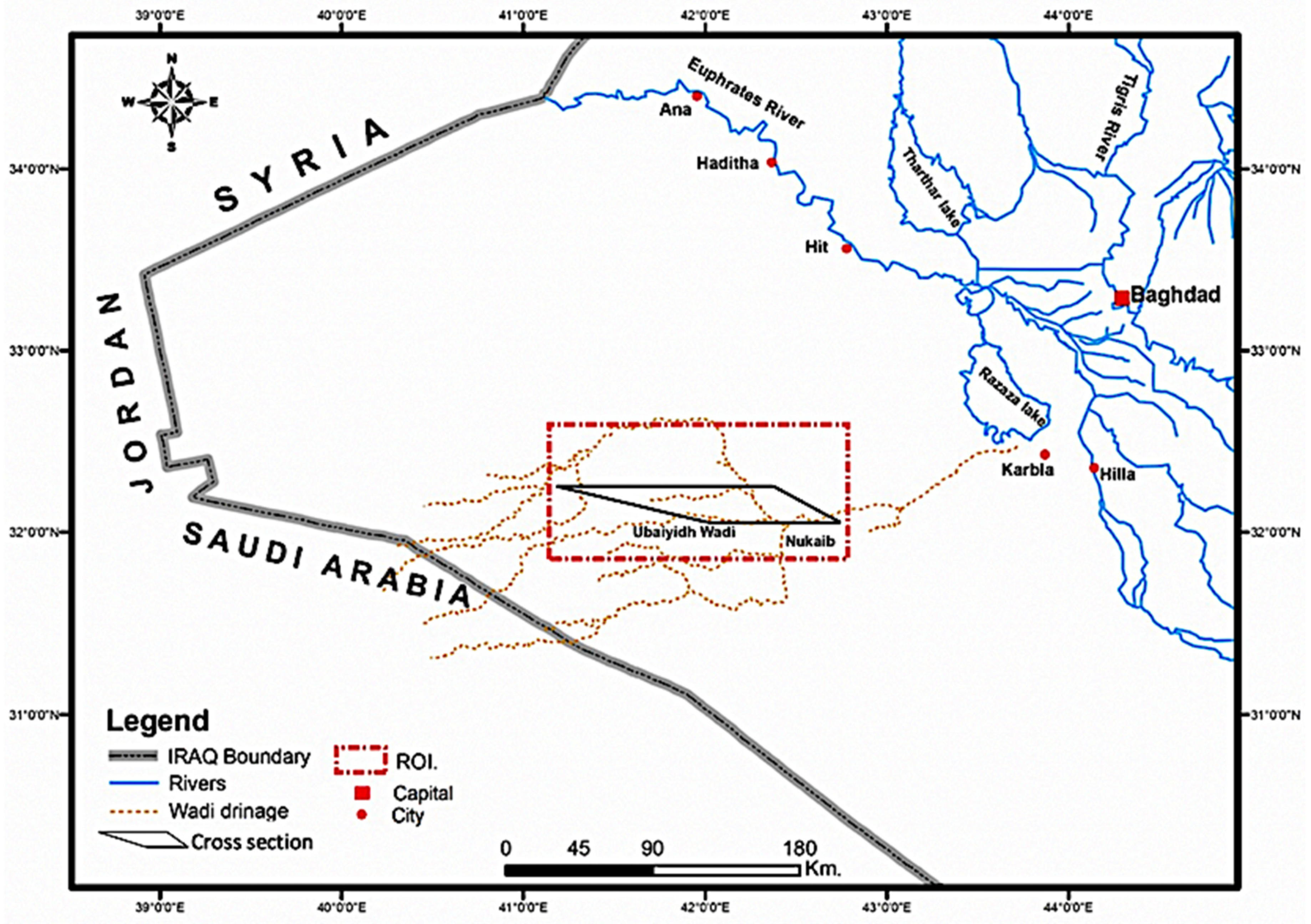
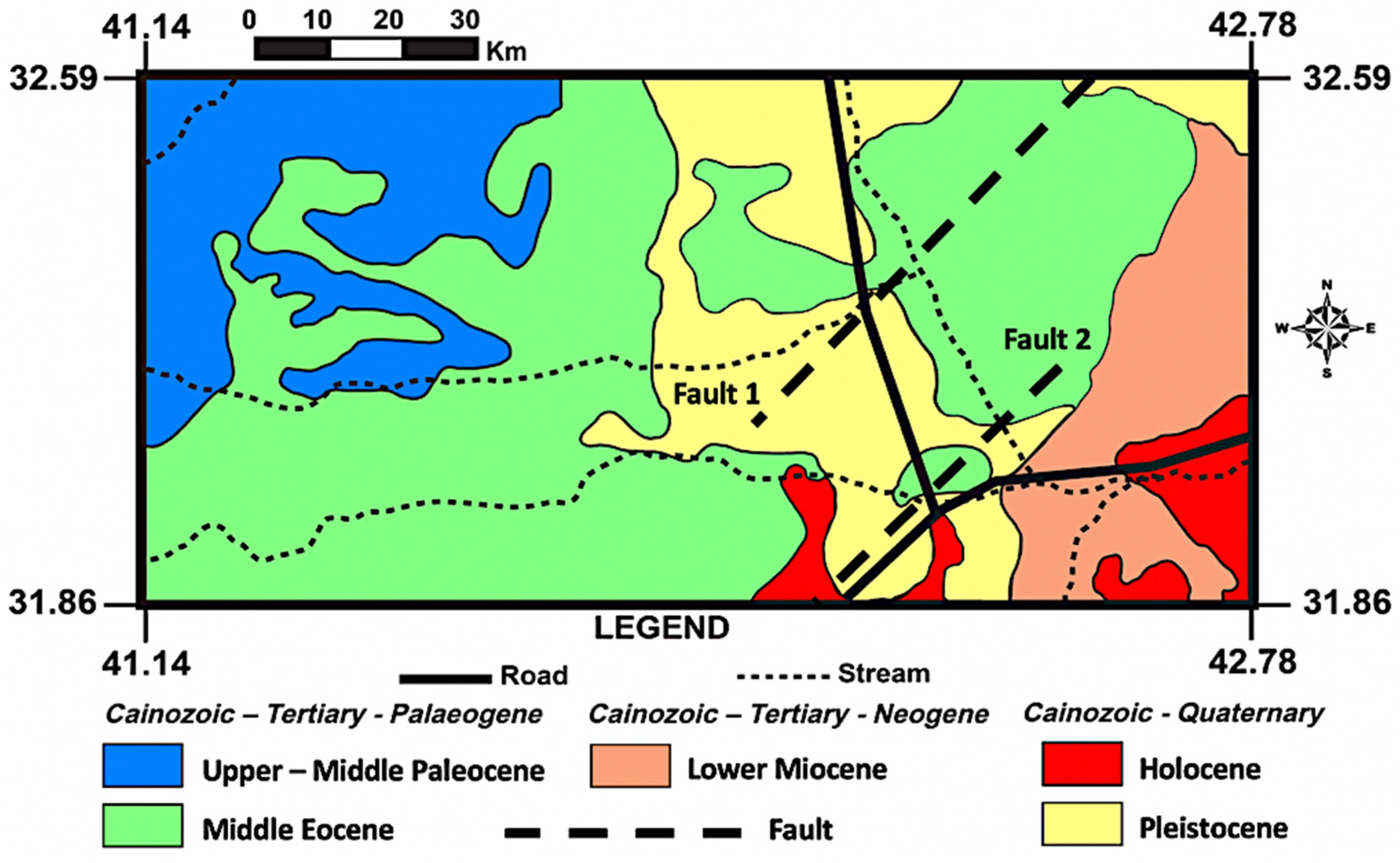
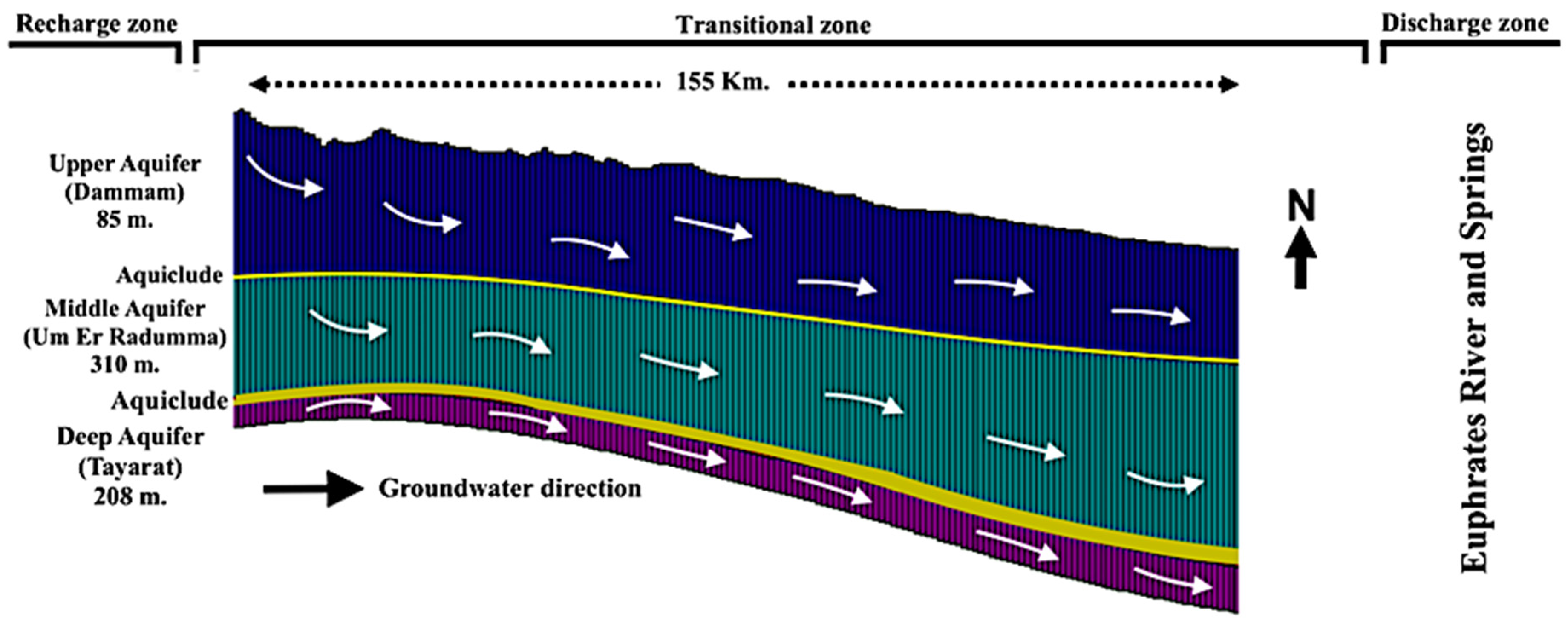
The Western Desert of Iraq (west of the Euphrates River) is an area covering nearly 32% of Iraq (437,072 km2) with ~1.3 million inhabitants [13]. The climate change phenomena have worsened the water shortages. Globally, the region is listed as one of the top five countries in terms of vulnerability to climate change, attributed to decreased water availability [14]. The climate change stress as an external challenge is inevitable and threatens, besides the population growth, urbanization and economic growth [15]. The region is classified as hyper-arid, with an annual mean for the rainfall ~141 mm and more than 85% recorded between November and March. The annual precipitations show that there is almost a one peaking event every 4 years (Figure 1) [16]. It is a flat terrain sloping gently at an average of ~0.002 degrees from the west towards the Euphrates River [17]. Due to low precipitation and high potential evaporation, a permanent vegetation cover does not exist [18]. The recharge zone is located far west where the aquifers are exposed, while the discharge zone is located nearby the Euphrates riverbank, represented by numerous springs. Generally, recharge occurs either directly through precipitation from the outcrops via cracks, or through the upward and downward leakages by the neighboring aquifers. Groundwater direction is following the gradient from the recharge to the discharge zone. Groundwater is found in several horizons at different depths. The groundwater flow net for the region has been described in-depth in a previous published work related to the same project showing the direction of groundwater flux is tending from West to East [19]. The majority of the groundwater is nonrenewable, flowing in a deep confined aquifer system. Recharge may occur locally. However, recharge only occurs through limited flood events which happen immediately after rapid and short rushes. The rough estimation of recharge is ~17.5 mm/year [16]. The region of interest is a part of the Western Desert (41.14° E–32.59° N and 42.78° E–31.86° N) covering an area of about 12,400 km2. It embeds in part from the main Ubaiydh wadi (the main wadi in the region). This local region was chosen because of two reasons. On one hand, it was classified by Consortium-Yugoslavia [20] as a promising groundwater exploitation zone, and on the other, it offers a sufficient number of pumping wells for carrying out a thorough groundwater study (Figure 2). The geological setting for the region has been described by [21,22], and [23], where the region belongs to the stable shelf zone/Rutba-Jazira subzone, the tectonic stress is orientated Southwest–Northeast, and the basement depth ranges from 5 km in the Jazira area up to 11 km south of Rutba. The Jazira area was part of the Rutba uplift domain in the late Permian to early Cretaceous time; the stratigraphy has shown the following formations: Euphrates-Lower Miocene, Dammam-Middle Eocene, Um Er Radumma–Middle/Upper and Tayarat-Upper Cretaceous, respectively. Limestone and dolomitic limestone are the most dominated units for these formations. Two local faults can be distinguished in the middle and eastern part. The main directions for these faults are Northeast–Southeast; these directions are related to the Najd-Hejaz origin movement, which belongs to the Precambrian-Palaeozoic. The two faults simulated in the model have been described as normal faults. The depth of the faults is over 300 m crossing the formations and aquifers which have been simulated in the geological map (Figure 3). The following three aquifers have been considered for the current study (Tayarat, Um Er Radumma and Dammam) and two aquicludes located in between the two formations Um Er Radumma and Tayarat working as an aquiclude. Lenses from marl are imbedded between Dammam and Umm Er-Radhumma formations (thin layers from Marl E recedes to W). Figure 4 is demonstrating the conceptual diagram of recharge processes. Table 1 indicates the aquifers main characteristics [24].

Figure 1.
Precipitation from Nukaib Station 1980–2008 (a) Monthly means; (b) Annual means [16].
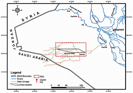
Figure 2.
Region of interest and case study.
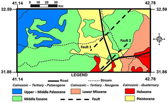
Figure 3.
Geological map.
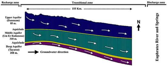
Figure 4.
Conceptual diagram of recharge processes.

Table 1.
Aquifers characteristics [24].
2.1. Methods
One of the challenges in simulating the groundwater flow system is the construction of reasonable conceptualization, which can replicate the aquifers’ geological heterogeneity and complexity, particularly in fault and fracture zones. To build a conceptual model, site-specific stratigraphic and hydraulic data must be assembled and analyzed for a better understanding and modelling of a groundwater system. However, the number of details in a conceptual model are proportional to the purpose of groundwater modelling and resolution. Recently, much software has been developed with an accessible graphical user interface (GUI) offering implicit modelling tools to create detailed conceptual models and convert them easily to a numerical solution, including folds, trenches, bench-outs, and faults. Software basically use one of the three available algorithms to solve groundwater flow problems such as the finite-difference (FD), finite-element (FE), and finite-volume methods (FV). The most frequently used FD method code is MODFLOW, as developed by the United States Geological Survey (USGS). MODFLOW developed codes are integrated to public domain groundwater software such as USGS Model Muse [25]; the Unsaturated Zone Flow Package (UZF) is a modified version of the MODFLOW that simulates the Unsaturated Zone [26]. This code was not used for the current work, due to the lack of proper data for the Unsaturated Zone and the limitation of three dimensioned simulation for the code itself. On the other hand, the Feflow, which is an FE-based code developed by Diersch 2002 [27], has the advantage over the FD method because of the compatibility to conceptual complex geologic boundaries using flexible finite element meshes. Feflow is integrated to commercial software called DHI Feflow developed by WASY GmbH, Germany. For this study, the FD-based software has been chosen. The finite difference method is the most direct partial differential solution, discretizing models regularly. Most of groundwater modelling software is designed for geological explorations and reservoir simulations. However, add-ons and coupling scripts allow hydrogeologists to get the benefits of exporting different horizons in readable formats that can be imported to 3D groundwater modelling software.
In this study, flow and budget models were constructed using MODFLOW-NWT [28], a Newton formulation of MODFLOW-2005 [29]. MODFLOW-NWT has the advantage of resolving the problem with dewatered or dry cells, particularly in areas where aquifers are partially saturated, as expected in this case study. The simulation was run with the Upstream-Weighting package (UPW) that treats nonlinearities of dry cells by using a smoothed continuous function of groundwater heads. The MODFLOW-NWT is widely used to solve problems regarding the considered thickness of the vadose zone along with the limitations associated with the two-phase flow and diffusion compatibility. In the unsaturated zone, air–water flow is the major pattern controlled by soil moisture content and potentiometer pressure.
2.2. Properties and Initial Data
The current model is limited to steady state simulation, providing static conditions of the hydraulic system; modeling of the transient condition would need more data. The standard requirement for groundwater modelling is the formulation of mathematical approaches and the integration of various hydrogeological properties. This includes the distribution of the hydraulic conductivities and static groundwater head, in addition to the coefficient of different aquifers. The discretization of the model in this study was based on a 500 × 500 m grid that was adequate for simulating flow and groundwater budget. The model included five stratigraphic layers with a total area of 12,400 km2 and 248,000 cells. The hydrostratigraphic succession was determined by five main layers, namely, Dammam aquifer, first aquiclude, Um Er Radumma aquifer, second aquiclude, and Tayarat aquifer. Each layer was projected to the Universal Transverse Mercator coordinate and World Geodetic system (UTM WGS 84) projection system. The bottom of each aquifer was constructed using Golden Software Surfer v.8 [30] and stratigraphic data of 102 boreholes [31]. For interpolation of the borehole, the inverse-distance algorithm of data was used. The surface topography was assigned based on a 30 × 30 m Shuttle Radar Topography Mission (SRTM) digital elevation model. Due to the lack of detailed hydrogeological data for the region, uniform Kf values for each stratigraphic formation have been used, and we then selected the reasonable range manually followed with automatic calibration. The conductivity (Kf) values were estimated and assigned for each layer. These were 1.0 × 10⁻⁴ m/s for the three aquifers and 1.0 × 10⁻⁸ m/s for the aquicludes. The Kf value of the fault zone is 3.3 × 10⁻⁵ m/s, and that was obtained from the field work of the previous study that conducted pumping tests close to the fault zone [19]. The effective porosity was assumed to be 15% for all layers while total porosity was assumed to be 30%. The storage coefficient was set to 1 × 10⁻⁵ (m) and specific yield to 20%. The effective porosity was assumed to be equal to specific yield of the unconfined aquifer. Since the aquiclude is mainly determined by clay—marl formations, 0.35 and 0.015 were assigned to the total and effective porosity, respectively. These are reports-based values according to the Waterloo Hydrogeologic Enviro-Base pro database. Generally speaking, data are very limited for the region, since the region is considered as a war zone, and the current work relies on the data available from the Ministry of Water Resources—Iraq.
2.3. Boundary Conditions
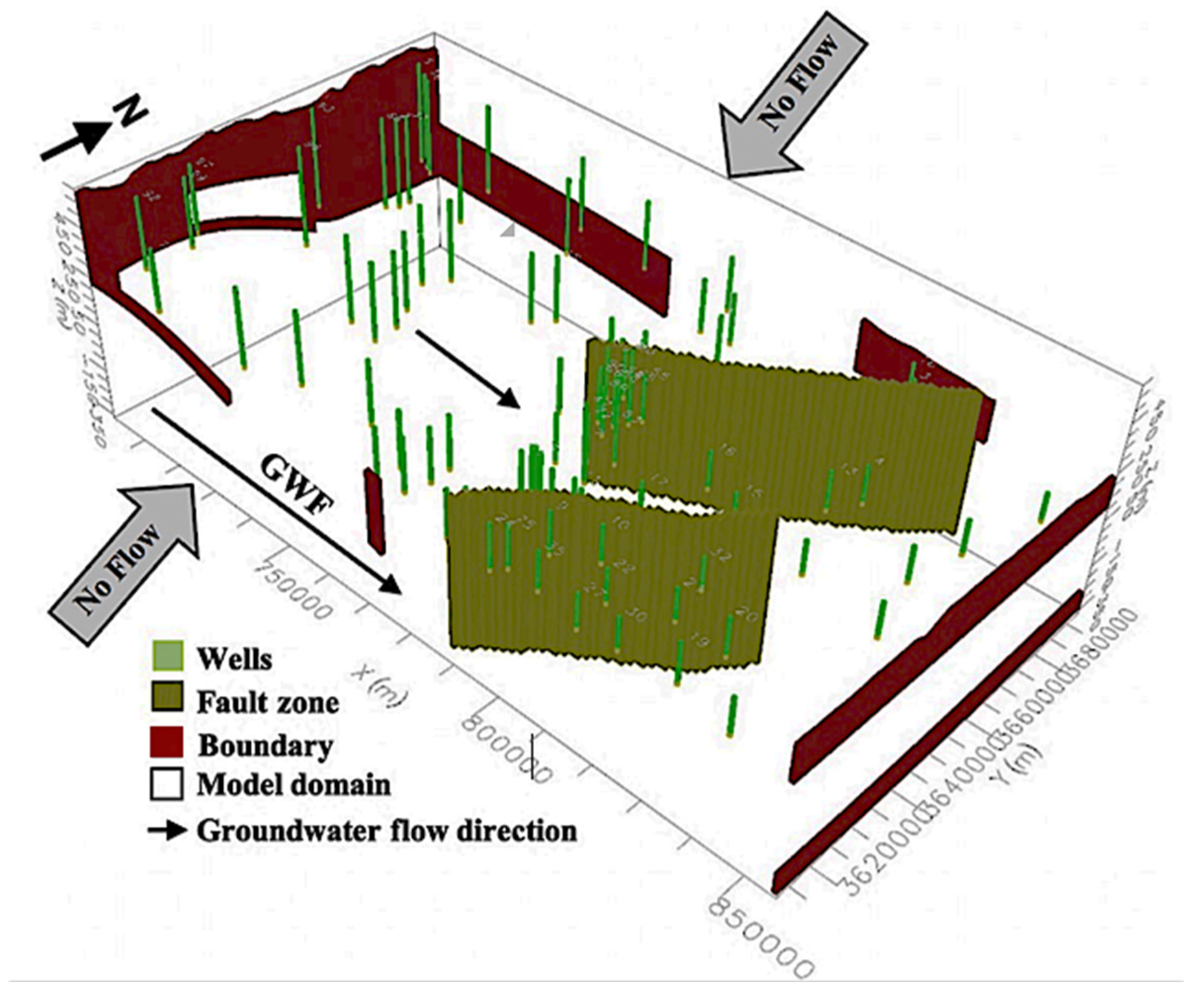
The general groundwater flow net tends from the far West towards the Euphrates River (East) [19]. The model area is, therefore, located between no-flow boundaries assigned to the North and South. Due to the different hydraulic conditions of successive layers from the top to bottom (unconfined, semi-confined, or confined conditions), the static groundwater level was assigned to the western and eastern boundaries of the model as a first-order boundary condition (constant head BC). The upper aquifer (left boundaries) were linearly interpolated from 480 m (upper left corner) to 450 m (lower left corner) of the model. The eastern boundaries were assigned at a constant value of 170 m. Due to the semi/confined conditions that controlled the eastern boundary of the model, it was assigned at 105 m a.s.l (Figure 5).
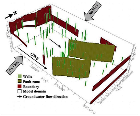
Figure 5.
Conceptual boundary model.
The fault zone of the area was simulated using a Horizontal Flow Barrier (HFB) Package included with MODFLOW crossing the model from the North to the South-East with an assumed thickness of 5 mm and assigned to the model using a Recharge (RCH) boundary package in MODFLOW for the interior region and an average hydraulic conductance of 3.3 × 10⁻⁵ m/s. To imitate the fault zone there are generally two options: either assign the obtained Kf value to the model cells where fault zone is distributed, or use a wall boundary condition—the so called Horizontal Flow Barrier (HFB) package included with MODFLOW. The package was developed to simulate thin, vertical, low-permeability features that could impede the horizontal groundwater flow. The boundary is assigned to the fault and adjacent cells in the finite difference grid (width of the barrier). The hydraulic characteristic of the barrier was then calculated by dividing the hydraulic conductivity of the barrier cells by the width of that barrier. The fault zone acted as a flow barrier in some parts of the model. The net recharge to the upper groundwater table was assumed to be ~17.5 mm/year in the West–Southwest areas of the model and 5 mm/year for the interior region. The water balance model from the period 1980–2008, as given in a previously conducted study, was used for the initial values. The actual evaporation was 1800 mm/year using the Thornthwaite equation with an assumed extinction depth of 0.15 m. [16].
2.4. Model Calibration
The model was calibrated by matching observed groundwater to calculated heads in 102 observation wells. As a forward problem, residuals in the groundwater head were decreased using hydraulic conductivity as major factor affecting groundwater flow in the region, employing the available range for the field site. The automatic gradient-based calibration was first accomplished using a trial-and-error method followed by using a model-independent parameter estimation and uncertainty analysis (PEST package). The observation wells were categorized in three head groups based on their screen location. The head distribution was calibrated by automatic adjustment of the horizontal hydraulic conductivities Kx,y [32]. In four run iterations the objective function was reduce it from 18513.3 to 150.08 which reflects the gradual decrease in head residuals.
3. Results and Discussion
3.1. Groundwater Modeling
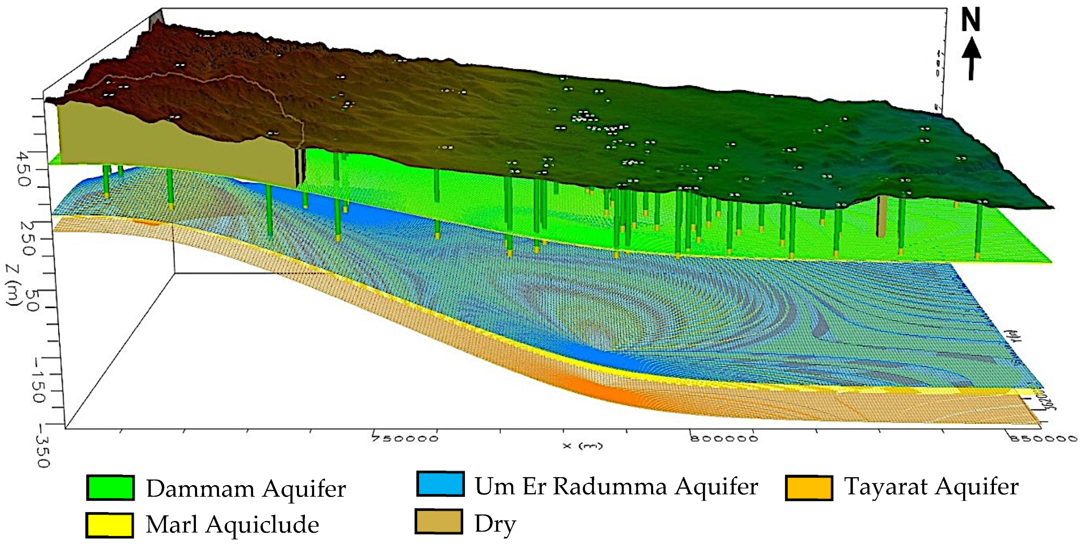
The calibrated model has been visualized in Figure 6. Dry cells occurred in the south-west part of the area of interest, at least for the first aquifer. Dry cells also occurred in MODFLOW models when the calculated water table was below the bottom elevation of the grid cell [33].
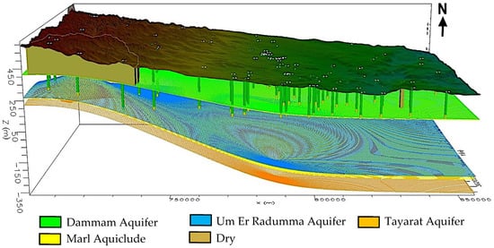
Figure 6.
Aquifers modelling and layers in the region of interest.
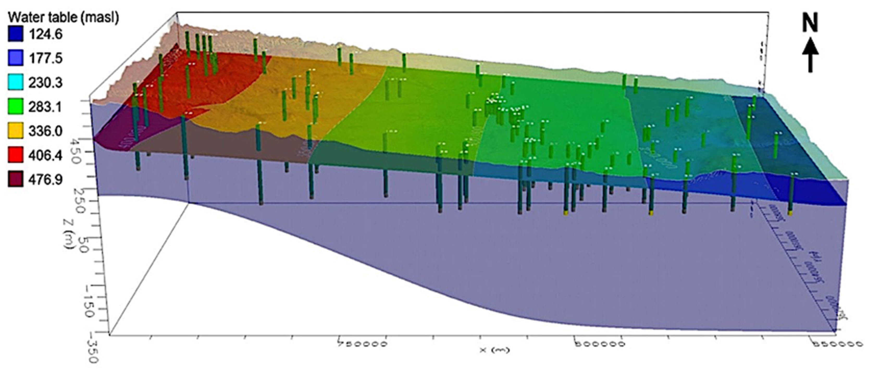
Because MODFLOW only simulates saturated groundwater flow in the standard model, it does not represent a head value in the unsaturated cell. Therefore, the cell becomes dry. The water tables showed the maximum values of 476 m.a.s.l. for the far West and the minimum value of 124 m.a.s.l. for the far East. These values were defined by constant head boundaries, which were implemented at the western and eastern boundaries of the model. No inactive cells or zones were included (Figure 7). The groundwater contour map for the upper Dammam aquifer shows that groundwater flow undergoes a slight change in the direction after reaching the fault zone. The same effect occurs in the two deeper aquifers, Um Er Radumma and Tayarat, which indicates the impact of the fault on groundwater flow.
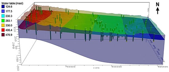
Figure 7.
Observation and irrigation wells and water table modelling.
3.2. Model Sensitivity
The results of sensitivity show that the aquifers 1,3,5 (Dammam, Um Er Radumma and Tyarat) are sensitive to the change of the longitudinal component of the hydraulic conductivity Kx with an average sensitivity value of 1.178–1.296, while a rather low sensitivity to other hydraulic conductivity values. (Table 2). This could be explained by the general groundwater flow direction with average velocities much higher than those in a transfer or vertical direction. That movement also limited the hydraulic impact of the fault zone, where groundwater flow obliquely to barrier. On the other hand, the model is sensitive to the groundwater recharge close the southwesterly part of the model, and a higher value than 17 mm/year caused model inconvergence and an unreasonable groundwater flow pattern.

Table 2.
Model sensitivity results.
3.3. Manual Calibration
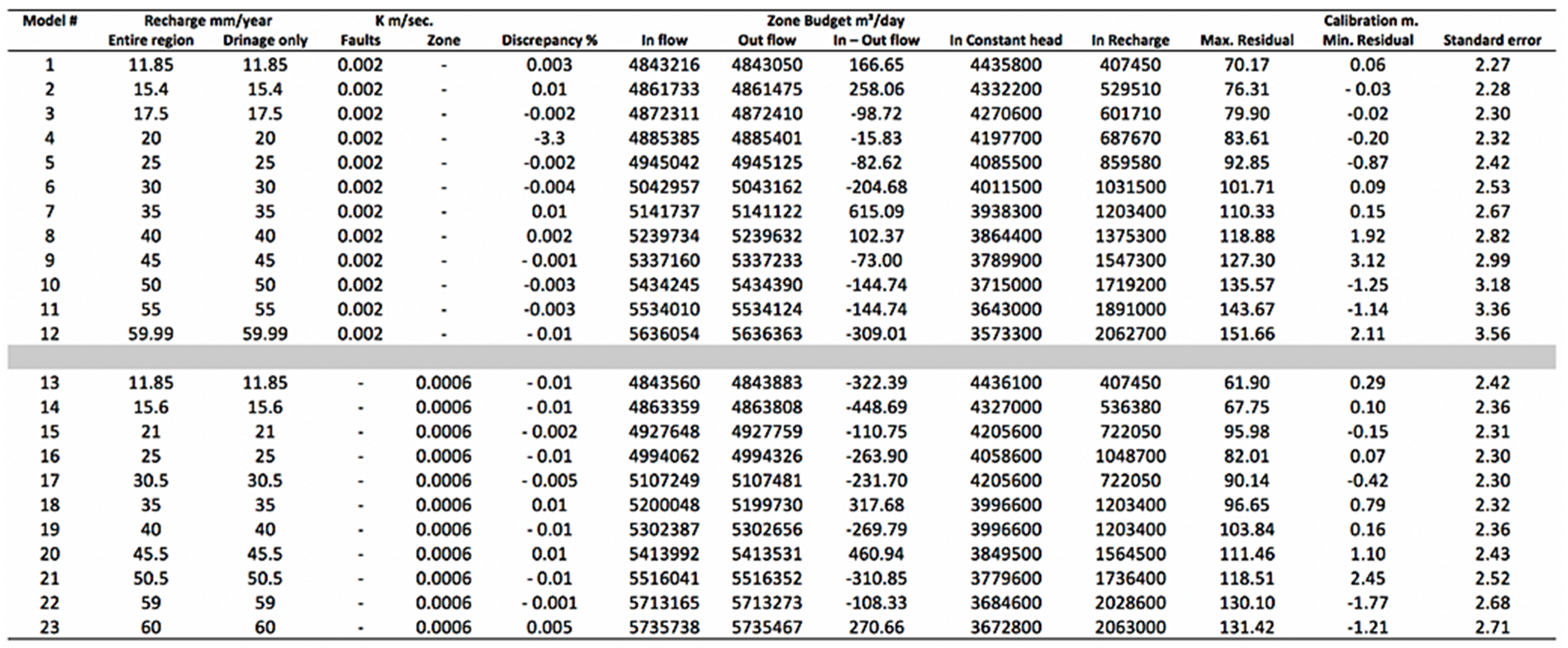
The models with a recharge of less than 11.85 mm/year or more than 60 mm/year did not converge and thus failed to produce a result (Figure 8). Model three was considered to be the most reliable model and considered to be an intial model for the subsequent automatic calibration. The sensitivities analysed in different K values were used for the aquifers and aquicludes (Table 3). The model ran stably with K values from 1 × 10⁻³ to 1 × 10⁻⁴ m/s for aquifers and from 1 × 10⁻⁷ to 1 × 10⁻⁸ m/s for aquicludes. The standard error showed only a small difference between model three and 3–1 (2.3 m to 2.331 m), while the maximum residual difference was between 79.9 m and 57.8 m.
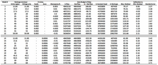
Figure 8.
Results for manual calibration and sensitivity.

Table 3.
Results for implemented model three and Kx values.
Because some of the absolute residuals were considerable, it could be speculated that either the reading of the depth of the groundwater or determination of the elevation of the wells was imprecise. By excluding wells with very high values, both the residual and standard errors were getting much better. Eleven observation wells out of 102 were excluded. Generally, water budget results showed the discrepancy for the final calibrated model was −0.002% with an inflow of 4,872,311 m3/day and outflow of 4,872,410 m3/day. The constant head and recharge rates were 4,270,600 m3/day and 601,710 m3/day.
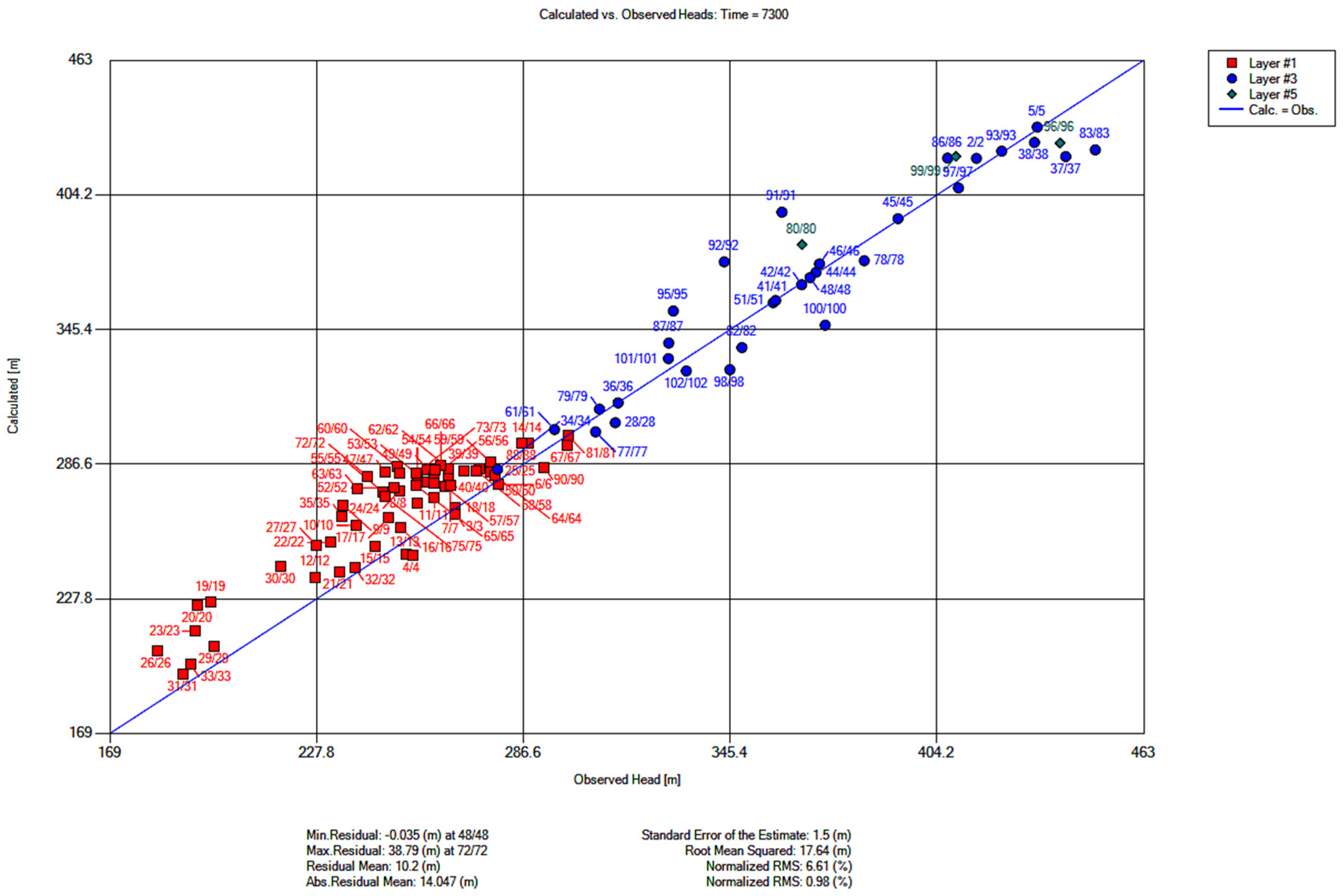
The results of the automatic calibration show significant enhancement and reduction in head residuals with mean residuals 10.2 m. The error of estimation after four iterations was 1.5 m (Figure 9). The automatic parameter optimization shows that, the Dammam and Tayarat Aquifers were not sensitive to the change in the Ky value, so after four iteration a homogenous K distribution was observed suggesting same K value. The optimized Kx,y values by mean of automatic calibration are listed in the Table 4.
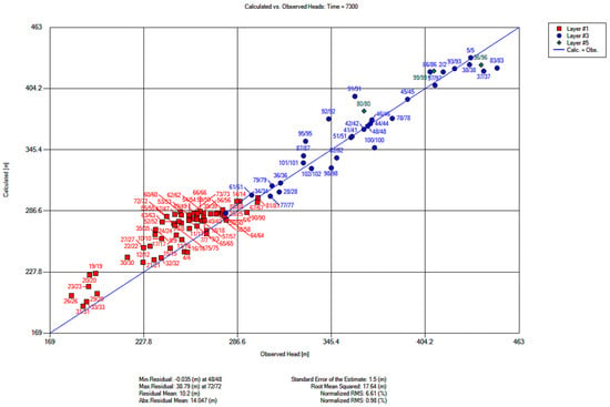
Figure 9.
Plots residuals of the model three after correction.

Table 4.
Optimized hydraulic conductivity.
3.4. Groundwater Harvesting
The average groundwater recharge was estimated to be ~17.5 mm/year (0.0175 m/year) and the total area of the region of interest was 12,400 Km2 (1.24 × 10¹⁰ m2). The water budget for recharge was then calculated as: 0.0175 × 12.4 × 109 m2 = 2.17 × 10⁸ m3/year.
For irrigation purposes, ~5000 L/m2/year of water are needed for open area farming [34], but only ~1000 L/m2/year of water are needed for greenhouse farming because evaporation will be reduced to ~80% [35], assuming that in greenhouse farming the amount of regional recharge is sufficient to utilize the groundwater for only 1.75% of the total area. This amount of water abstraction is minimal, but it might be increased by taking into consideration the groundwater inflow into the region of interest from Saudi Arabia. However, this amount of water will be available in the long term only if both Iraq and Saudi Arabia come to a mutual agreement to avoid the depletion of any aquifers in case groundwater abstraction is conducted with an absence of water resource management from either side. Table 5 illustrates the groundwater inflow calculation made by the model in terms of constant head values. Fifty to sixty percent of the groundwater external recharge was assumed to be utilized from the total amount and the results show that ~7% of the total area could be covered by greenhouse farming if both regional recharge and groundwater inflow are considered.

Table 5.
External recharge calculation.
4. Conclusions
Estimating groundwater recharge is challenging, particularly for arid and semi-arid regions, due to the spatial and temporal variability of climate data and a negative water budget. Therefore, implementing numerical modelling for groundwater and employing a sensitivity analysis approach can provide a better understanding of the hydraulic system and a more reasonable estimation of groundwater recharge. However, results are affected by the amount and quality of available data. The study, therefore, suggests using a sensitivity analysis followed by a calibration approach to check the model variability and limitation under different stress factors. The model in the study included three aquifers based on 102 observing and irrigation wells, in addition to two fault zones. The boundary conditions for the model were located between no-flow boundaries assigned to the North and South. Five layers have been assigned (three aquifers and two aquicludes). Dry cells occurred in the south-west part of the area of interest at least in the first aquifer, because water table being below the bottom elevation of the grid cell. The groundwater flow undergoes a slight change in the direction after reaching the fault zone. The same effect occurs in the two deeper aquifers, Um Er Radumma, and Tayarat, which indicates the impact of the fault on groundwater flow.
Sensitivity analyses showed sensitivity to the change of the Kx value as a result of the major groundwater discharge flow pattern from West to the East (parallel to the longitudinal model extension). The aquifers are sensitive to the change of the longitudinal component of the hydraulic conductivity Kx with an average sensitivity value of 1.178–1.296. On the other hand, the model is sensitive to the groundwater recharge close the southwestern part of the model that estimated ~17.5 mm/year. The manual calibration process showed that model three was considered to be the most reliable model and considered as an initial model for the subsequent automatic calibration. The standard error for the model showed only a small difference between model three and 3–1 (2.3 m to 2.331 m), while the maximum residual difference was between 79.9 m and 57.8 m. The automatic calibration showed significant enhancement in head residuals with mean residuals of 10.2 m. The error of estimation after four iterations was 1.5 m.
With good agricultural practice and external inflow into the region of interest from Saudi Arabia, ~7% of groundwater could be invested in greenhouse farming. The current model is limited to steady state simulations, providing static conditions of the hydraulic system; modeling of transient conditions would need more data which is a subject for a future project.
Author Contributions
Conceptualization, S.W.H.A.-M. and R.A.; methodology, S.W.H.A.-M. and R.A.; software, S.W.H.A.-M. and R.A.; validation, S.W.H.A.-M. and R.A., M.O.K. and F.M.A.; resources, S.W.H.A.-M.; M.O.K. and F.M.A. data curation, S.W.H.A.-M. and R.A.; writing—original draft preparation, S.W.H.A.-M.; writing—review and editing, S.W.H.A.-M.; R.A.; M.O.K. and F.M.A. visualization, S.W.H.A.-M. and R.A.; All authors have read and agreed to the published version of the manuscript.
Funding
This research received no external funding.
Conflicts of Interest
The authors declare no conflict of interest.
References
- Anderson, M.P.; Woessner, W.W.; Hunt, R.J. Applied Groundwater Modeling: Simulation of Flow and Advective Transport; Academic Press: Wyman Street, Waltham, MA, USA, 2015. [Google Scholar]
- Finch, J.W. Estimating Direct Groundwater Recharge Using a Simple Water Balance Model–Sensitivity to Land Surface Parameters. J. Hydrol. 1998, 211, 112–125. [Google Scholar] [CrossRef]
- Mehl, S.; Hill, M.C. Locally Refined Block-Centered Finite-Difference Groundwater Models: Evaluation of Parameter Sensitivity and the Consequences for Inverse Modelling and Predictions. Acta Univ. Carolina. Geol. 2002, 46, 199–203. [Google Scholar]
- Shoemaker, W.B.; Kuniansky, E.L.; Birk, S.; Bauer, S.; Swain, E.D. Documentation of a Conduit Flow Process (CFP) for MODFLOW-2005: U.S. Geological Survey Techniques and Methods, Book 6, Chapter A24. 2008, p. 50. Available online: http://www.academia.edu/download/48243513/tm6-A24.pdf (accessed on 23 July 2020).
- Carrera-Hernández, J.J.; Smerdon, B.D.; Mendoza, C.A. Estimating Groundwater Recharge through Unsaturated Flow Modelling: Sensitivity to Boundary Conditions and Vertical Discretization. J. Hydrol. 2012, 452, 90–101. [Google Scholar] [CrossRef]
- Song, x.; Zhang, J.; Zhan, C.; Xuan, Y.; Ye, M.; ×u, C. Global Sensitivity Analysis in Hydrological Modeling: Review of Concepts, Methods, Theoretical Framework, and Applications. J. Hydrol. 2015, 523, 739–757. [Google Scholar] [CrossRef]
- Xanke, J.; Jourde, H.; Liesch, T.; Goldscheider, N. Numerical Long-Term Assessment of Managed Aquifer Recharge from a Reservoir into a Karst Aquifer in Jordan. J. Hydrol. 2016, 540, 603–614. [Google Scholar] [CrossRef]
- Hanson, R.T.; Boyce, S.E.; Schmid, W.; Hughes, J.D.; Mehl, S.W.; Leake, S.A.; Maddock, T., III; Niswonger, R.G. One-Water Hydrologic Flow Model (MODFLOW-OWHM) (No. 6-A51); US Geological Survey: Preston, WV, USA, 2014.
- Hartmann, A. Experiences in Calibrating and Evaluating Lumped Karst Hydrological Models. Geol. Soc. Lond. Spec. Publ. 2018, 466, 331–340. [Google Scholar] [CrossRef]
- Bittner, A.K.; Ferraz, M.C. Reliability of Mesopic Measures of Visual Acuity and Contrast Sensitivity and their Correlation with Rod and Cone Function in Retinitis Pigmentosa. Ophthalmic Res. 2020, 63, 133–140. [Google Scholar] [CrossRef] [PubMed]
- Sarrazin, F. Understanding the Sensitivity of Karst Groundwater Recharge to Climate and Land Cover Changes at a Large-Scale. Ph.D. Thesis, University of Bristol, Bristol, UK, 2018. [Google Scholar]
- Teixeira Parente, M.; Bittner, D.; Mattis, S.A.; Chiogna, G.; Wohlmuth, B. Bayesian Calibration and Sensitivity Analysis for a Karst Aquifer Model Using Active Subspaces. Water Resour. Res. 2019, 55, 7086–7107. [Google Scholar] [CrossRef]
- NIC. Republic of Iraq National Investment Commission. 2004. Available online: http://www.iraq-jccme.jp/pdf/090416-4.pdf (accessed on 19 June 2020).
- Alrusheidat, J.; Aljaafreh, S. Climate change adaptation and technology transfer: The path to disaster risk reduction in the arid and semi-arid zones. The case of Jordan. New Medit 2016, 15, 2–7. [Google Scholar]
- Bishay, F. Towards Sustainable Agricultural Development in Iraq. The Transition from Relief, Rehabilitation and Reconstruction to Development. 2003. Available online: https://agris.fao.org/agris-search/search.do?recordID=XF2008434245 (accessed on 23 July 2020).
- Al-Muqdadi, S.W. Groundwater Investigation and Modeling-Western Desert of Iraq. Ph.D. Thesis, Technische Universität Bergakademie Freiberg, Freiberg, Germany, 2012. [Google Scholar]
- Al-Muqdadi, S.W.; Merkel, B.J. Automated Watershed Evaluation of Flat Terrain. J. Water Resour. Prot. 2011, 3, 892. [Google Scholar] [CrossRef][Green Version]
- Adham, A.; Sayl, K.N.; Abed, R.; Abdeladhim, M.A.; Wesseling, J.G.; Riksen, M.; Fleskens, L.; Karim, U.; Ritsema, C.J. A Gis-Based Approach for Identifying Potential Sites for Harvesting Rainwater in the Western Desert of Iraq. Int. Soil Water Conserv. Res. 2018, 6, 297–304. [Google Scholar] [CrossRef]
- Al-Muqdadi, S.W.; Merkel, B.J. Interpretation of Groundwater Flow into Fractured Aquifer. Int. J. Geosci. 2012, 3, 357–364. [Google Scholar] [CrossRef]
- Consortium, Y. Hydrogeological Explorations and Hydrotechnical Work—Western Desert of Iraq. Blook7. (Directorate of Western Desert Development Projects. Baghdad, Iraq). Unpublished work. 1977. [Google Scholar]
- Jassim, S.Z.; Goff, J.C. (Eds.) Geology of Iraq; DOLIN, sro; Geological Society of London: London, UK, 2006. [Google Scholar]
- Buday, T.; Hak, J. The Geological Survey of the Western Part of the Western Desert. No. 1000; The State Company of Geological Survey and Mining: Baghdad, Iraq, 1980.
- Buday, T.; Jassim, S.Z. Tectonic Map of Iraq, Scale 1: 1000 000; GEOSURV: Baghdad, Iraq, 1984. [Google Scholar]
- Jawad, S.B.; Naom, F.H.; Zamil, H.I.; Mohammad, A.B. Hydrogeology of Groundwater aquifers in the Western Desert-West and Southwest of the Euphrates River. (Ministry of Irrigation. Baghdad. Iraq). Unpublished work. 2001. [Google Scholar]
- Winston, R.B. ModelMuse: A Graphical User Interface for MODFLOW-2005 and PHAST; US Geological Survey: Reston, VA, USA, 2009.
- SGS. UZF Unsaturated-Zone Flow Package. 2020. Available online: https://water.usgs.gov/nrp/gwsoftware/modflow2000/MFDOC/inde×.html?uzf_unsaturated_zone_flow_pack.htm (accessed on 30 June 2020).
- Diersch, H.J.G. WASY Software-FEFLOW Finite Element Subsurface Flow and Transport Simulation System Reference Manual; WASY: Berlin, Germany, 2002. [Google Scholar]
- Niswonger, R.G.; Panday, S.; Ibaraki, M. MODFLOW-NWT, a Newton Formulation for MODFLOW-2005. US Geol. Surv. Tech. Methods 2011, 6, 44. [Google Scholar]
- Harbaugh, A.W. MODFLOW-2005, the Us Geological Survey Modular Ground-Water Model: The Ground-Water Flow Process; US Department of the Interior: Washington, DC, USA; US Geological Survey: Reston, VA, USA, 2005; p. 6-A16.
- Golden Software, Inc. 809 14th Street, Golden, Colorado 80401-1866 USA. Available online: https://www.goldensoftware.com (accessed on 17 February 2016).
- Ministry of Water Resources, Groundwater Division and Database. Ministry of Water Resource, Iraq 2010, Unpublished. Available online: https://www.mowr.gov.iq (accessed on 8 February 2020).
- Doherty, J. PEST Model-Independent Parameter Estimation User Manual; Watermark Numerical Computing: Brisbane, Australia, 2004; Volume 3338, p. 3349. [Google Scholar]
- Chiang, W.H. 3D-Groundwater Modeling with PMWIN: A Simulation System for Modeling Groundwater Flow and Transport Processes; Springer Science & Business Media: Berlin, Germany, 2005. [Google Scholar]
- Smith, M.; Muñoz, G.; Sanz Alvarez, J. Irrigation Techniques for Small-Scale Farmers: Key Practices for DRR Implementers. 2014. Available online: http://www.fao.org/3/a-i3765e.pdf (accessed on 19 March 2020).
- Fernandes, C.; Corá, J.E.; Araújo, J.A.C.D. Reference Evapotranspiration Estimation inside Greenhouses. Sci. Agric. 2003, 60, 591–594. [Google Scholar] [CrossRef]
© 2020 by the authors. Licensee MDPI, Basel, Switzerland. This article is an open access article distributed under the terms and conditions of the Creative Commons Attribution (CC BY) license (http://creativecommons.org/licenses/by/4.0/).


