Modelling Hydrological Processes and Identifying Soil Erosion Sources in a Tropical Catchment of the Great Barrier Reef Using SWAT
Abstract
:1. Introduction
2. Material and Methods
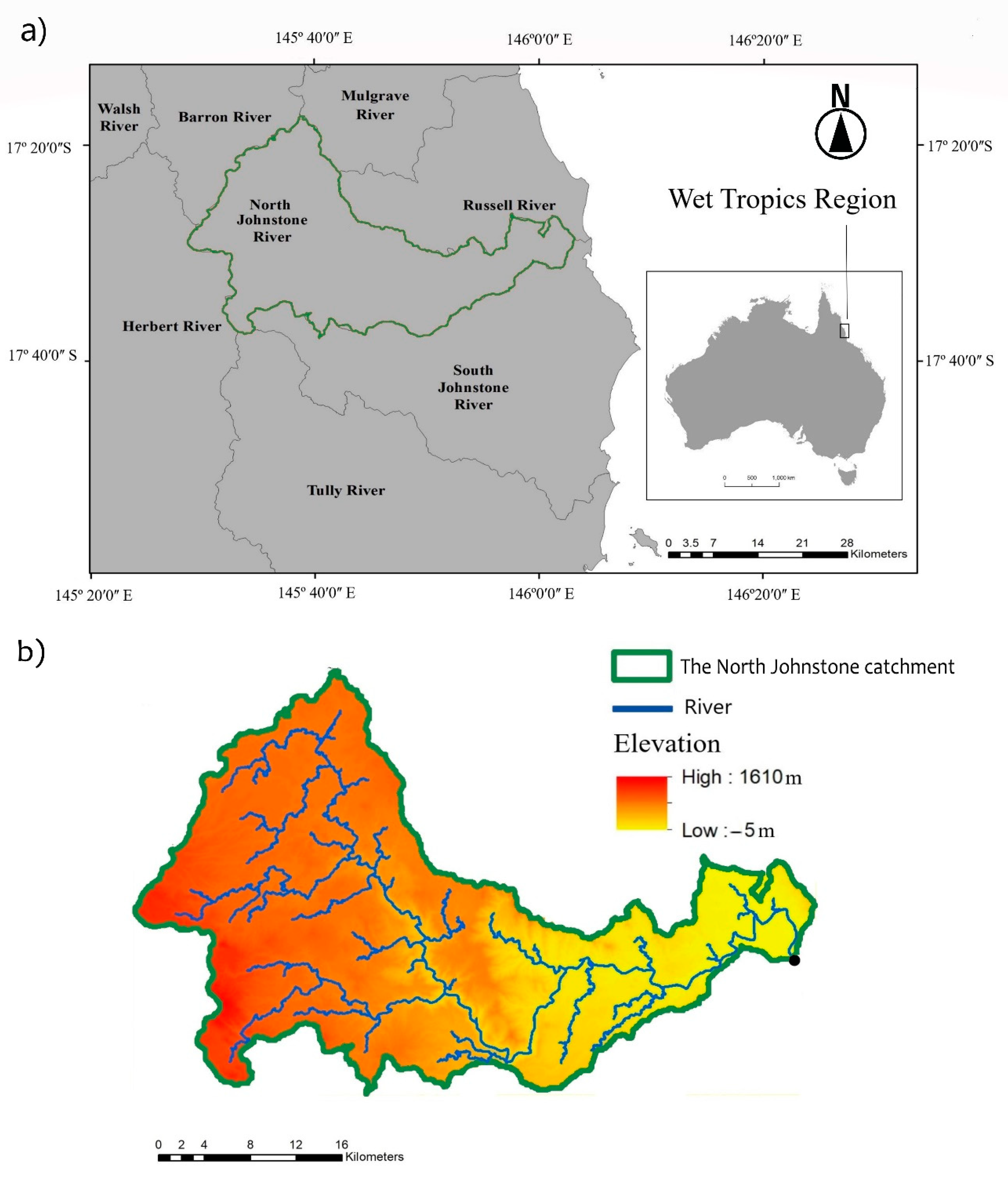
2.1. Study Area
2.2. Soil and Water Assessment Tool (SWAT)
2.3. Model Input Data
2.3.1. Hydrological Observation Data
2.3.2. Sediment Loads Observation Data
2.4. Actual Evapotranspiration Database
2.5. SWAT Model Setup
2.5.1. Model Setup
2.5.2. Parameterisation of the Vegetative Cover
2.6. Model Calibration and Validation
2.6.1. Measuring the Model Performance
2.6.2. Model Calibration
3. Results
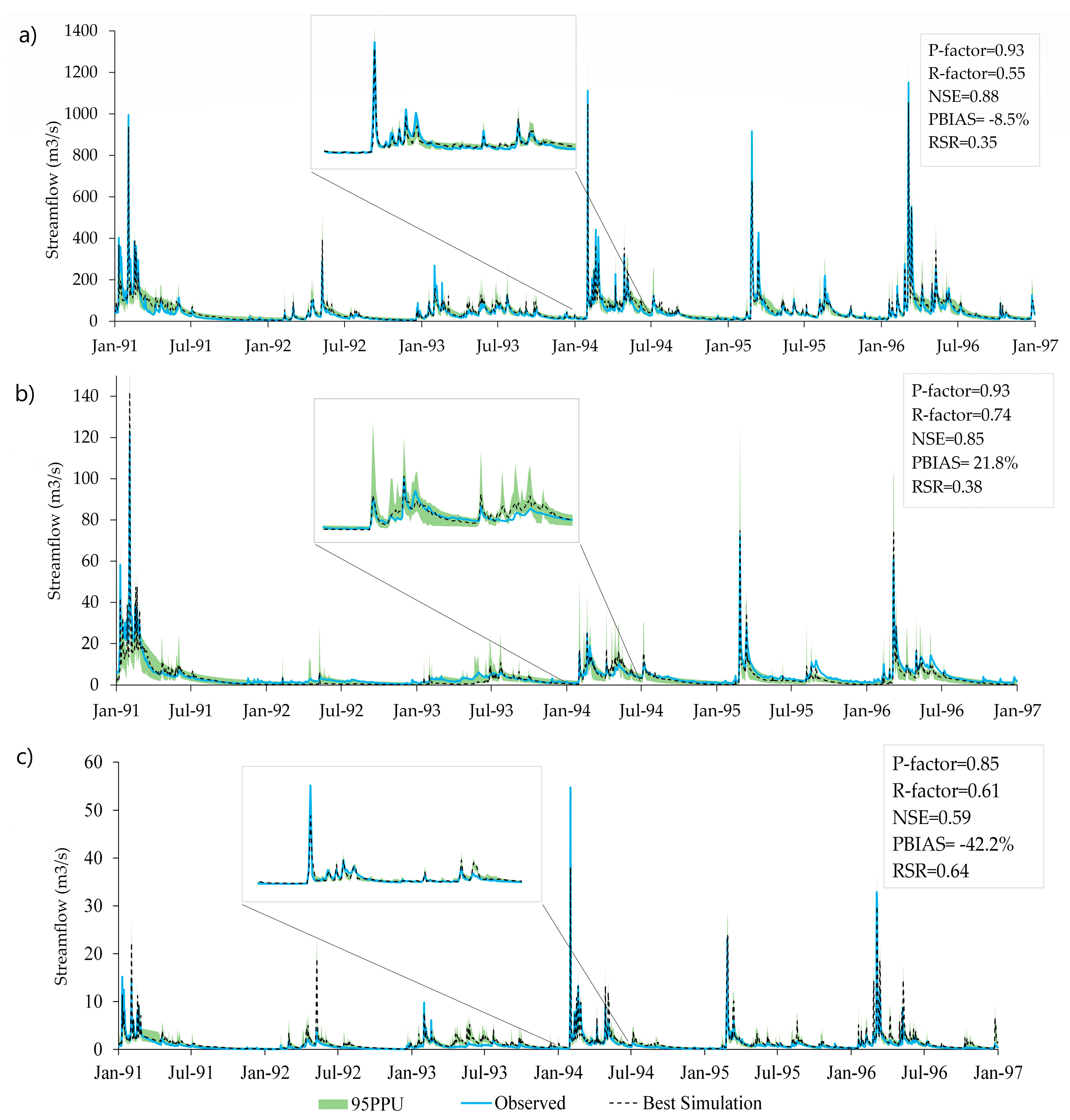
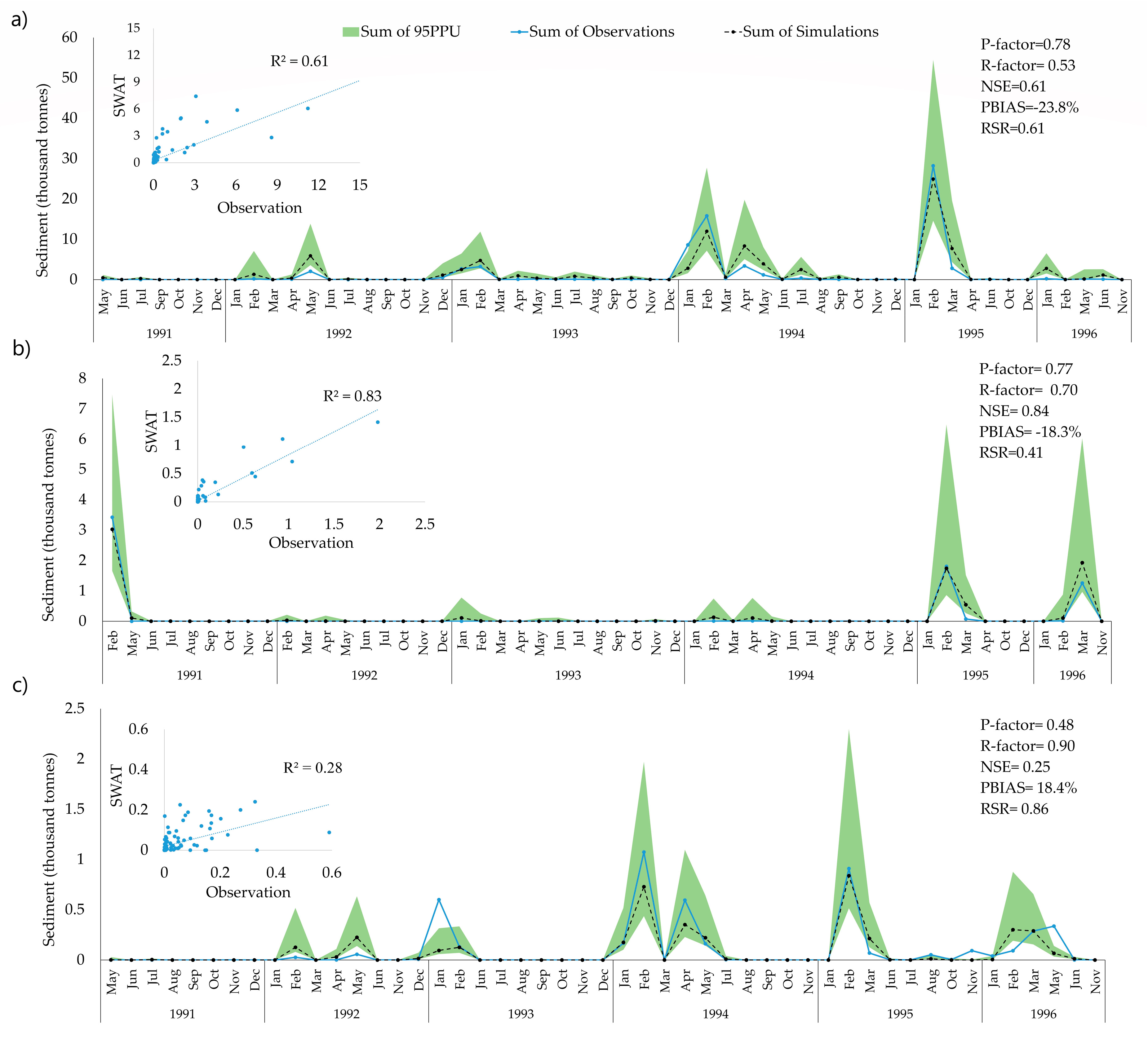
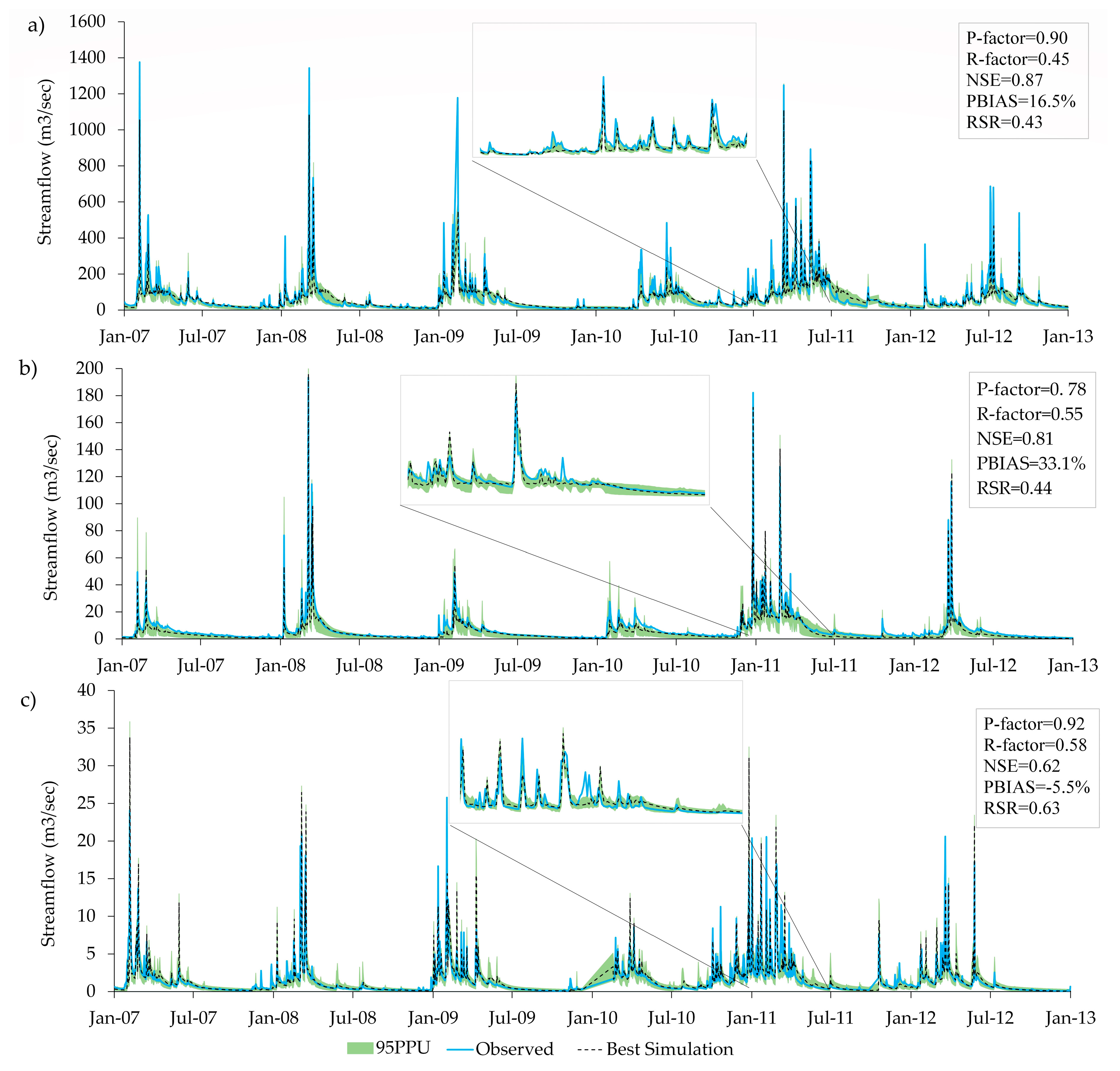
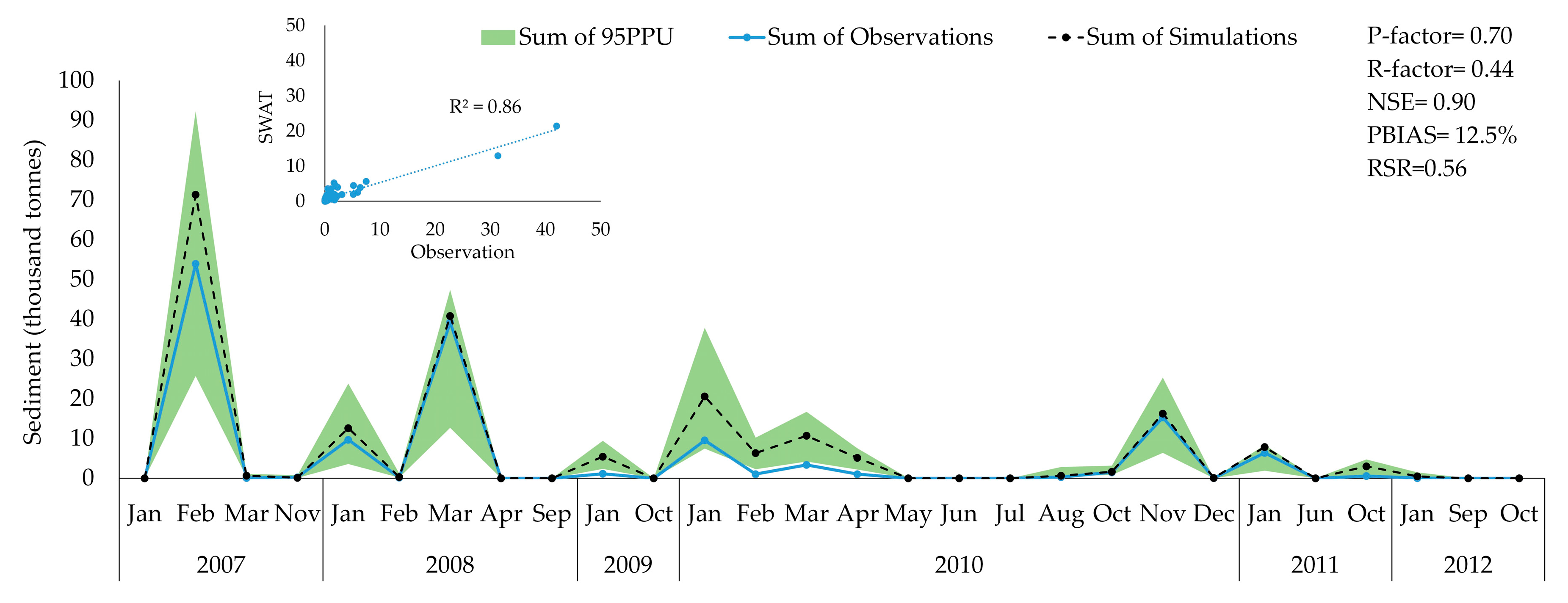
3.1. Model Calibration and Validation Results
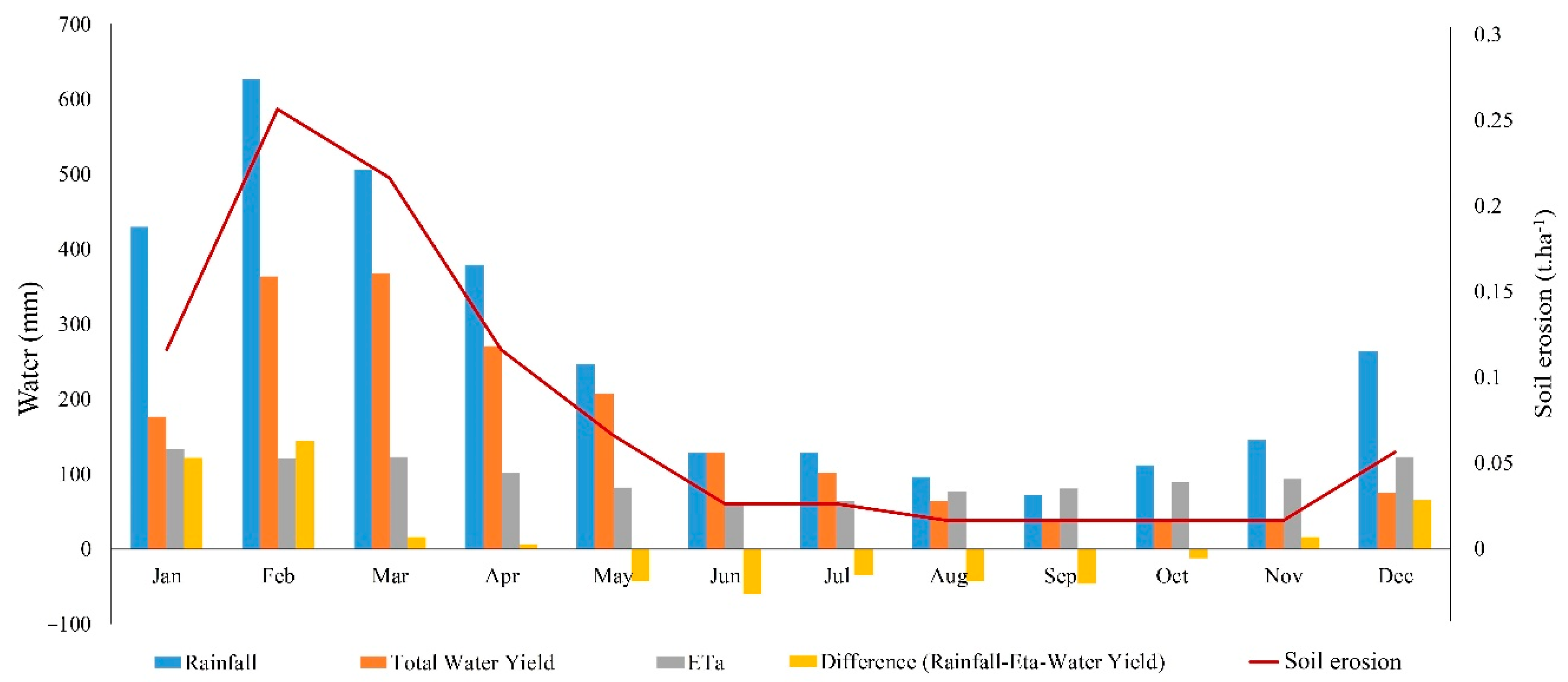
3.2. Water Balance and Sediment Budget
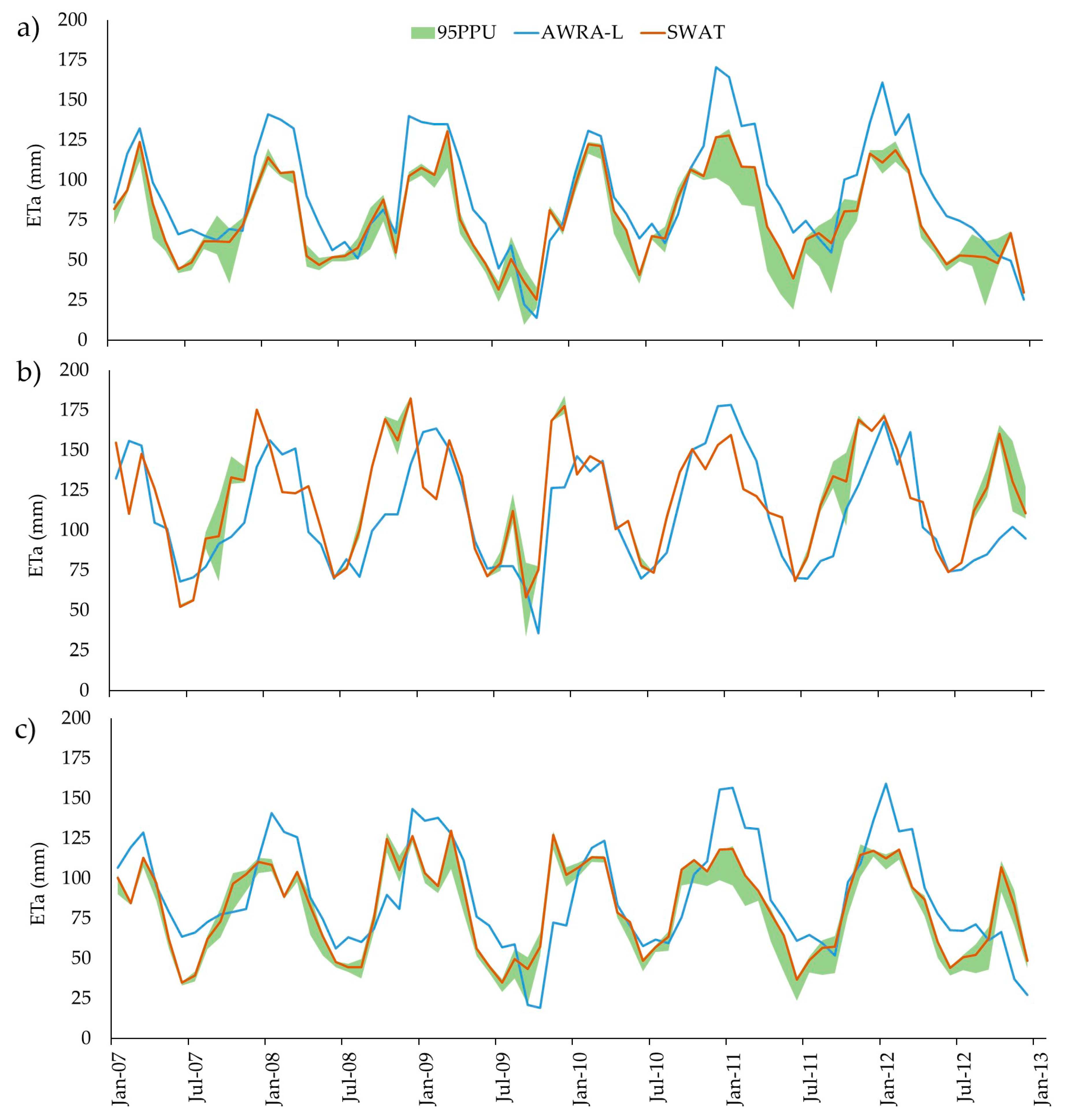
3.3. SWAT Performance in Simulating ETa Compared to AWRA-L
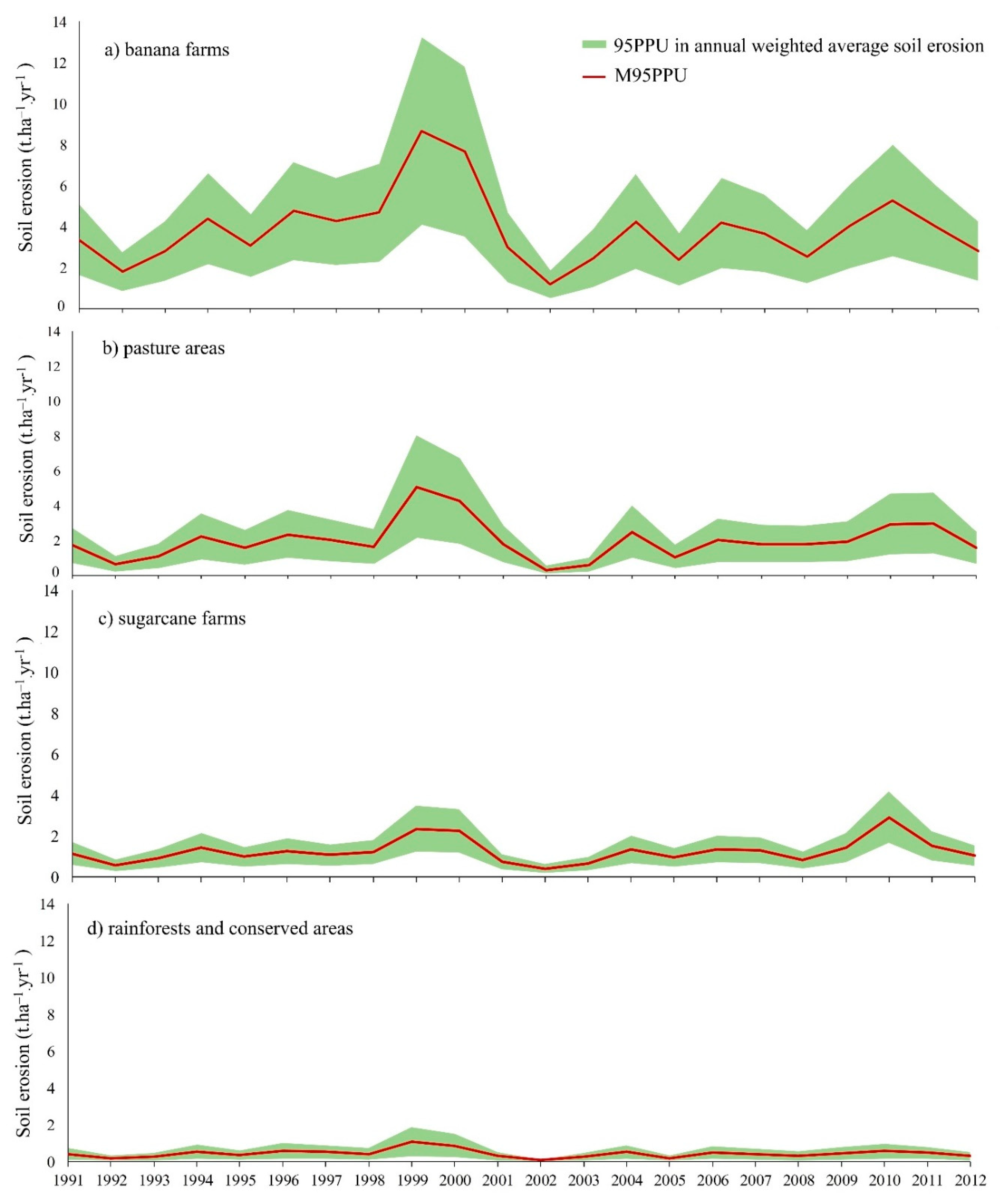
3.4. Soil Erosion
4. Discussion
4.1. Comparison Soil Erosion with Previous Studies
4.2. Hillslope Soil Erosion Modelling for GBR Catchments
4.3. The Effectiveness of Reforestation on Steep Slopes
5. Conclusions
Author Contributions
Funding
Acknowledgments
Conflicts of Interest
References
- Griggs, P.D. Too much water: Drainage schemes and landscape change in the sugar-producing areas of Queensland, 1920–1990. Aust. Geogr. 2018, 49, 81–105. [Google Scholar] [CrossRef]
- Evans, M.C. Deforestation in Australia: Drivers, trends and policy responses. Pac. Conserv. Biol. 2016, 22, 130–150. [Google Scholar] [CrossRef]
- Rasiah, V.; Florentine, S.K.; Williams, B.L.; Westbrooke, M.E. The impact of deforestation and pasture abandonment on soil properties in the wet tropics of Australia. Geoderma 2004, 120, 35–45. [Google Scholar] [CrossRef] [Green Version]
- Bradshaw, C.J. Little left to lose: Deforestation and forest degradation in Australia since European colonization. Plant Ecol. 2012, 5, 109–120. [Google Scholar] [CrossRef]
- Kroon, F.J. Towards ecologically relevant targets for river pollutant loads to the Great Barrier Reef. Mar. Pollut. Bull. 2012, 65, 261–266. [Google Scholar] [CrossRef]
- Waterhouse, J.; Brodie, J.; Tracey, D.; Smith, R.; Vandergragt, M.; Collier, C.; Petus, C.; Baird, M.; Kroon, F.; Mann, R.; et al. The Risk from Anthropogenic Pollutants to Great Barrier Reef Coastal and Marine Ecosystems. In Scientific Consensus Statement 2017: A Synthesis of the Science of Land-Based Water Quality Impacts on the Great Barrier Reef; Queensland Department of Environment and Science: Brisbane, Australia, 2017. Available online: https://www.reefplan.qld.gov.au/__data/assets/pdf_file/0032/45995/2017-scientific-consensus-statement-summary-chap03.pdf (accessed on 1 August 2020).
- Waterhouse, J.; Schaffelke, B.; Bartley, R.; Eberhard, R.; Brodie, J.; Star, M.; Thorburn, P.; Rolfe, J.; Ronan, M.; Taylor, B.; et al. Overview of Key Findings, Management Implications and Knowledge Gaps. In 2017 Scientific Consensus Statement: Land Use Impacts on the Great Barrier Reef Water Quality and Ecosystem Condition; Queensland Department of Environment and Science: Brisbane, Australia, 2017. Available online: https://www.reefplan.qld.gov.au/__data/assets/pdf_file/0034/45997/2017-scientific-consensus-statement-summary-chap05.pdf (accessed on 1 August 2020).
- Bartley, R.; Thompson, C.; Croke, J.; Pietsch, T.; Baker, B.; Hughes, K.; Kinsey-Henderson, A. Insights into the history and timing of post-European land use disturbance on sedimentation rates in catchments draining to the Great Barrier Reef. Mar. Pollut. Bull. 2018, 131, 530–546. [Google Scholar] [CrossRef] [PubMed]
- Hairsine, P.B. Sediment-Related Controls on the Health of the Great Barrier Reef. Vadose Zone J. 2017, 16, 1–15. [Google Scholar] [CrossRef] [Green Version]
- Ebner, B.C.; Fulton, C.J.; Donaldson, J.A.; Schaffer, J. Distinct habitat selection by freshwater morays in tropical rainforest streams. Ecol. Freshw. Fish. 2016, 25, 329–335. [Google Scholar] [CrossRef]
- Wilkinson, S.N.; Dougall, C.; Kinsey-Henderson, A.E.; Searle, R.D.; Ellis, R.J.; Bartley, R. Development of a time-stepping sediment budget model for assessing land use impacts in large river basins. Sci. Total Environ. 2014, 468, 1210–1224. [Google Scholar] [CrossRef] [PubMed] [Green Version]
- Herr, A.; Kuhnert, P.M. Assessment of uncertainty in Great Barrier Reef catchment models. Water Sci. Technol. 2007, 56, 181–188. [Google Scholar] [CrossRef] [PubMed]
- Hunter, H.M.; Walton, R.S. Land-use effects on fluxes of suspended sediment, nitrogen and phosphorus from a river catchment of the Great Barrier Reef, Australia. J. Hydrol. 2008, 356, 131–146. [Google Scholar] [CrossRef]
- Armour, J.D.; Hateley, L.R.; Pitt, G.L. Catchment modelling of sediment, nitrogen and phosphorus nutrient loads with SedNet/ANNEX in the Tully–Murray basin. Mar. Freshw. Res. 2009, 60, 1091–1096. [Google Scholar] [CrossRef] [Green Version]
- Gladish, D.W.; Kuhnert, P.M.; Pagendam, D.E.; Wikle, C.K.; Bartley, R.; Searle, R.D.; Ellis, R.J.; Dougall, C.; Turner, R.D.; Lewis, S.E.; et al. Spatio-temporal assimilation of modelled catchment loads with monitoring data in the Great Barrier Reef. Ann. Appl. Stat. 2016, 10, 1590–1618. [Google Scholar] [CrossRef]
- Hughes, A.O.; Croke, J.C. Validation of a spatially distributed erosion and sediment yield model (SedNet) with empirically derived data from a catchment adjacent to the Great Barrier Reef Lagoon. Mar. Freshw. Res. 2011, 62, 962–973. [Google Scholar] [CrossRef]
- Hateley, L.R.; Ellis, R.; Shaw, M.; Waters, D.; Carroll, C. Modelling Reductions of Pollutant Loads Due to Improved Management Practices in the Great Barrier Reef Catchments—Wet Tropics NRM Region; Technical Report; Queensland Department of Natural Resources and Mines: Cairns, Australia, 2014; Volume 3, ISBN 978-0-7345-0441-8.
- An-Vo, D.A.; Mushtaq, S.; Reardon-Smith, K.; Kouadio, L.; Attard, S.; Cobon, D.; Stone, R. Value of seasonal forecasting for sugarcane farm irrigation planning. Eur. J. Agron. 2019, 104, 37–48. [Google Scholar] [CrossRef]
- An-Vo, D.A.; Reardon-Smith, K.; Mushtaq, S.; Cobon, D.; Kodur, S.; Stone, R. Value of seasonal climate forecasts in reducing economic losses for grazing enterprises: Charters Towers case study. Rangel. J. 2019, 41, 165–175. [Google Scholar] [CrossRef] [Green Version]
- Henderson, B.; Bui, E. Determining Uncertainty in Sediment & Nutrient Transport Models for Ecological Risk Assessment (No. 2); CSIRO: Canberra, Australia, 2005. [Google Scholar]
- Fu, B.; Merritt, W.S.; Croke, B.F.; Weber, T.; Jakeman, A.J. A review of catchment-scale water quality and erosion models and a synthesis of future prospects. Environ. Model. Softw. 2019, 114, 75–97. [Google Scholar] [CrossRef]
- Neitsch, S.L.; Arnold, J.G.; Kiniry, J.R.; Williams, J.R. Soil and Water Assessment Tool Theoretical Documentation Version 2009; Texas Water Resources Institute: College Station, TX, USA, 2011. [Google Scholar]
- Abbaspour, K.C. SWAT-CUP4: SWAT Calibration and Uncertainty Programs—A User Manual; Swiss Federal Institute of Aquatic Science and Technology, Eawag: Überland, Switzerland, 2011. [Google Scholar]
- Bartley, R.; Waters, D.; Turner, R.; Kroon, F.; Wilkinson, S.; Garzon-Garcia, A.; Kuhnert, P.; Lewis, S.; Smith, R.; Bainbridge, Z.; et al. Sources of Sediment, Nutrients, Pesticides and other Pollutants to the Great Barrier Reef. In Scientific Consensus Statement 2017: A Synthesis of the Science of Land-Based Water Quality Impacts on the Great Barrier Reef; Queensland Department of Environment and Science: Brisbane, Australia, 2017. Available online: https://www.reefplan.qld.gov.au/__data/assets/pdf_file/0031/45994/2017-scientific-consensus-statement-summary-chap02.pdf (accessed on 1 August 2020).
- Wilkinson, C.; Brodie, J. Catchment Management and Coral Reef Conservation; James Cock University: Douglas, Australia, 2011. [Google Scholar]
- Marden, M. Effectiveness of reforestation in erosion mitigation and implications for future sediment yields, East Coast catchments, New Zealand: A review. N. Z. Geog. 2012, 68, 24–35. [Google Scholar] [CrossRef]
- Delevaux, J.M.; Whittier, R.; Stamoulis, K.A.; Bremer, L.L.; Jupiter, S.; Friedlander, A.M.; Poti, M.; Guannel, G.; Kurashima, N.; Winter, K.B.; et al. A linked land-sea modeling framework to inform ridge-to-reef management in high oceanic islands. PLoS ONE 2018, 13, e0193230. [Google Scholar] [CrossRef] [Green Version]
- Faruqi, S.; Wu, A.; Brolis, E.; Ortega, A.A.; Batista, A. The Business of Planting Trees: A Growing Investment Opportunity; World Resources Institute: Washington, DC, USA, 2018. [Google Scholar]
- Carlson, R.R.; Foo, S.A.; Asner, G.P. Land use impacts on coral reef health: A ridge-to-reef perspective. Front. Mar. Sci. 2019, 6, 562. [Google Scholar] [CrossRef]
- Preece, N.D.; Van Oosterzee, P.; Lawes, M.J. Planting methods matter for cost-effective rainforest restoration. Ecol. Manag. Restor. 2013, 14, 63–66. [Google Scholar] [CrossRef]
- Cheesman, A.W.; Preece, N.D.; van Oosterzee, P.; Erskine, P.D.; Cernusak, L.A. The role of topography and plant functional traits in determining tropical reforestation success. J. Appl. Ecol. 2018, 55, 1029–1039. [Google Scholar] [CrossRef] [Green Version]
- Ndomba, P.; Mtalo, F.; Killingtveit, A. SWAT model application in a data scarce tropical complex catchment in Tanzania. Phys. Chem. Earth 2008, 33, 626–632. [Google Scholar] [CrossRef]
- Alansi, A.W.; Amin, M.S.M.; Halim, F.A.; Shafri, H.Z.M.; Aimrum, W. Validation of SWAT model for stream flow simulation and forecasting in Upper Bernam humid tropical river basin, Malaysia. Hydrol. Earth. Syst. Sci. Discuss. 2009, 1, 6. [Google Scholar] [CrossRef]
- Fukunaga, D.C.; Cecílio, R.A.; Zanetti, S.S.; Oliveira, L.T.; Caiado, M.A.C. Application of the SWAT hydrologic model to a tropical watershed at Brazil. Catena 2015, 125, 206–213. [Google Scholar] [CrossRef]
- Williams, J.R.; LaSeur, W.V. Water yield model using SCS curve numbers. J. Hydr. Eng. DIV 1976, 102, 12379. [Google Scholar]
- Monteith, J.L. Evaporation and environment. In Symposia of the Society for Experimental Biology; Cambridge University Press: Cambridge, UK, 1965; pp. 205–234. [Google Scholar]
- Hargreaves, G.L.; Hargreaves, G.H.; Riley, J.P. Irrigation water requirements for Senegal River basin. J. Irrig. Drain. E-ASCE 1985, 111, 265–275. [Google Scholar] [CrossRef]
- Priestley, C.H.B.; Taylor, R.J. On the assessment of surface heat flux and evaporation using large-scale parameters. Mon. Weather Rev. 1972, 100, 81–92. [Google Scholar] [CrossRef]
- Willams, J.R. Sediment-yield prediction with universal equation using runoff energy factor. In Present and Prospective Technology for Predicting Sediment Yields and Sources; US Department of Agriculture, Agriculture Research Service: Washington, DC, USA, 1975. [Google Scholar]
- Williams, J.R.; Berndt, H.D. Sediment yield prediction based on watershed hydrology. Trans. ASAE 1977, 20, 1100–1104. [Google Scholar] [CrossRef]
- Bagnold, R.A. Bed load transport by natural rivers. Water Resour. Res. 1977, 13, 303–312. [Google Scholar] [CrossRef]
- Bureau of Agricultural and Resource Economics and Sciences. The Australian Land Use and Management Classification Version 8; Bureau of Agricultural and Resource Economics and Sciences: Canberra, Australia, 2016.
- McKenzie, N.J.; Jacquier, D.W.; Maschmedt, D.J.; Griffin, E.A.; Brough, D.M. The Australian Soil Resource Information System (ASRIS) Technical Specifications, Revised Version 1.6; CSIRO: Canberra, Australia, 2012.
- Walling, D.E.; WEBB, B.W. The Reliability of Suspended Sediment Load Data. In Erosion and Sediment Transport Measurement, Proceedings of the Florence Symposium, Firenze, Italy, 22–26 June 1981; Volume 133, pp. 177–194. Available online: https://iahs.info/uploads/dms/iahs_133_0177.pdf (accessed on 1 August 2020).
- Frost, A.J.; Ramchurn, A.; Smith, A. The Australian Landscape Water Balance Model. (AWRA-L v6). Technical Description of the Australian Water Resources Assessment Landscape Model. Version 6; Bureau of Meteorology Technical Report: Melbourne, Australia, 2018.
- Daggupati, P.; Pai, N.; Ale, S.; Douglas-Mankin, K.R.; Zeckoski, R.W.; Jeong, J.; Parajuli, P.B.; Saraswat, D.; Youssef, M.A. A recommended calibration and validation strategy for hydrologic and water quality models. Trans. ASABE 2015, 58, 1705–1719. [Google Scholar]
- Baez-Gonzalez, A.D.; Kiniry, J.R.; Meki, M.N.; Williams, J.; Alvarez-Cilva, M.; Ramos-Gonzalez, J.L.; Magallanes-Estala, A.; Zapata-Buenfil, G. Crop parameters for modeling sugarcane under rainfed conditions in Mexico. Sustainability 2017, 9, 1337. [Google Scholar] [CrossRef] [Green Version]
- Robertson, M.J.; Bonnett, G.D.; Hughes, R.M.; Muchow, R.C.; Campbell, J.A. Temperature and leaf area expansion of sugarcane: Integration of controlled-environment, field and model studies. Funct. Plant. Biol. 1998, 25, 819–828. [Google Scholar] [CrossRef]
- Keating, B.A.; Robertson, M.J.; Muchow, R.C.; Huth, N.I. Modelling sugarcane production systems I. Development and performance of the sugarcane module. Field Crops. Res. 1999, 61, 253–271. [Google Scholar] [CrossRef]
- Guimarães, M.J.M.; Coelho Filho, M.A.; Peixoto, C.P.; Gomes Junior, F.D.A.G.; Oliveira, V.V.M. Estimation of leaf area index of banana orchards using the method LAI-LUX. Water Resour. Irrig. Manag. 2013, 2, 71–76. [Google Scholar]
- Gilmour, D.A. Catchment Water Balance Studies on the Wet Tropical Coast of North Queensland. Ph.D. Thesis, James Cook University, Townsville, Australia, 1975. [Google Scholar]
- Moriasi, D.N.; Zeckoski, R.W.; Arnold, J.G.; Baffaut, C.; Malone, R.W.; Daggupati, P.; Guzman, J.A.; Saraswat, D.; Yuan, Y.; Wilson, B.N.; et al. Hydrologic and water quality models: Key calibration and validation topics. Trans. ASABE 2015, 58, 1609–1618. [Google Scholar]
- Abbaspour, K.C.; Johnson, C.A.; Van Genuchten, M.T. Estimating uncertain flow and transport parameters using a sequential uncertainty fitting procedure. Vadose Zone J. 2004, 3, 1340–1352. [Google Scholar] [CrossRef]
- McKay, M.D.; Beckman, R.J.; Conover, W.J. Comparison of three methods for selecting values of input variables in the analysis of output from a computer code. Technometrics 1979, 21, 239–245. [Google Scholar]
- Abbaspour, K.C.; Vaghefi, S.A.; Srinivasan, R. A guideline for successful calibration and uncertainty analysis for soil and water assessment: A review of papers from the 2016 International SWAT Conference. Water 2018, 10, 6. [Google Scholar] [CrossRef] [Green Version]
- Arnold, J.G.; Allen, P.M. Automated methods for estimating baseflow and ground water recharge from streamflow records 1. J. Am. Water. Resour. Assoc. 1999, 35, 411–424. [Google Scholar] [CrossRef]
- Brooks, A.; Spencer, J.; Borombovits, D.; Pietsch, T.; Olley, J. Measured hillslope erosion rates in the wet-dry tropics of Cape York, northern Australia: Part 2, RUSLE-based modeling significantly over-predicts hillslope sediment production. Catena 2014, 122, 1–17. [Google Scholar] [CrossRef]
- Teng, H.; Rossel, R.A.V.; Shi, Z.; Behrens, T.; Chappell, A.; Bui, E. Assimilating satellite imagery and visible–near infrared spectroscopy to model and map soil loss by water erosion in Australia. Environ. Model. Softw. 2016, 77, 156–167. [Google Scholar] [CrossRef]
- Armour, J.D.; Davis, A.; Masters, B.; Mortimore, C.; Whitten, M. Paddock Scale Water Quality Monitoring of Sugarcane and Banana Management Practices: Final Technical Report 2010–2013 Wet Seasons; Wet Tropics Region, Queensland Department of Natural Resources and Mines, Centre for Tropical Water & Aquatic Ecosystem Research and Queensland Department of Agriculture, Fisheries and Forestry for Terrain Natural Resource Management: Mareeba, Australia, 2013. [Google Scholar]




| Data | Scale | Detail | Source of Data |
|---|---|---|---|
| Digital Elevation Model | 25 m | Elevation, Slope and Length | The State of Queensland, Department of Natural Resources, Mines and Energy (https://data.qld.gov.au/dataset/digital-elevation-models-25metre-by-catchment-areas-series) |
| Land use map | 1:50,000 (Figure 2b) | Land use of the region, version 8 classification | Queensland Land Use Mapping Program, Australian Bureau of Agricultural and Resource Economics and Sciences [42] (https://www.qld.gov.au/environment/land/vegetation/mapping/qlump-datasets) |
| Soil map | 1:250,000 22 separated soil profiles | Physical properties for soil profiles including soil erodibility factor (USLE_k) dataset | Australian Soil Resource Information System, level 4 specification [43] (http://www.asris.csiro.au/) |
| Watercourses | Watercourse, connector, stream, river, creek, gully, canal, drain, channel, drainage | The state of Queensland, Department of Natural Resources, Mines and Energy, 2018 (https://data.qld.gov.au/dataset/watercourse-identification-map-queensland-series) | |
| Climate | 6 stations (1980–2012) (Figure 2d) | Daily precipitation (mm), maximum/minimum temperature (°C), relative humidity (%) and solar radiation (MJ/m2) | Gridded data of SILO (scientific information for land owners) (https://silo.longpaddock.qld.gov.au/point-data) |
| Parameters | Description |
|---|---|
| Groundwater and baseflow | |
| GW_DELAY | Groundwater delay |
| GWQMN | Threshold depth of water in the shallow aquifer required for return flow to occur |
| ALPHA_BF | Baseflow recession coefficient |
| Evapotranspiration | |
| GW_REVAP | Groundwater revap * coefficient |
| CANMX | Maximum canopy storage |
| REVAPMN | Threshold depth of water in the shallow aquifer for revap to occur |
| EPCO | Plant uptake compensation factor |
| Runoff and Streamflow | |
| SOL_K | Saturated soil conductivity |
| CH_K1 | Effective hydraulic conductivity in tributary channel |
| CH_K2 | Effective hydraulic conductivity in the main channel |
| CH_N1 | Manning′s “n” value for tributary channels |
| CH_N2 | Manning′s “n” value for the main channel |
| CN2 | SCS daily curve number |
| OV_N | Manning’s “n” value for overland flow |
| Soil erosion parameters | |
| USLE_K | USLE soil erodibility factor |
| USLE_C | USLE cover and management factor |
| USLE_P | USLE support practice factor |
| Sediment transportation | |
| SPCON | Coefficient in sediment transport equation |
| SPEXP | Exponent in sediment transport equation |
| CH_COV1 | Channel erodibility factor |
| CH_COV2 | Channel cover factor |
| Parameters | Sensitivity Ranking | Sensitivity | Land Use/Sub-Catchments | Lower Bound | Upper Bound | Fitted Value | |
|---|---|---|---|---|---|---|---|
| p-Stat | t-Stat | ||||||
| USLE_C | 1 | 0.00 | −38.81 | Pasture | 0.01 | 0.03 | 0.01 |
| USLE_K * | 2 | 0.00 | −16.80 | All land uses | −0.2 | 0 | −0.20 |
| CH_N1 | 3 | 0.00 | 16.48 | All sub-catchments | 0.1 | 0.2 | 0.13 |
| USLE_C | 4 | 0.00 | −10.55 | Banana and sugarcane | 0.01 | 0.08 | 0.06 |
| CH_K1 | 5 | 0.00 | 9.00 | All sub-catchments | 0 | 50 | 27.29 |
| CN2 | 6 | 0.00 | −7.33 | Pasture | 50 | 65 | 52.58 |
| OV_N | 7 | 0.00 | 3.39 | Pasture | 0.2 | 0.4 | 0.34 |
| SOL_K * | 8 | 0.04 | 2.06 | Midsection and coastal zone sub-catchments | −0.2 | 0 | −0.16 |
| ALPHA_BF | 9 | 0.04 | 2.02 | Upper section sub-catchments | 0.03 | 0.1 | 0.06 |
| CH_N2 | 10 | 0.05 | 1.93 | All sub-catchments | 0.01 | 0.04 | 0.03 |
| CH_COV2 | 11 | 0.07 | −1.85 | All sub-catchments | 0.01 | 0.04 | 0.02 |
| USLE_C | 12 | 0.10 | −1.63 | Rainforest | 0.001 | 0.006 | 0.00 |
| USLE_P | 13 | 0.11 | −1.60 | Banana | 0.8 | 1 | 0.80 |
| SPCON | 14 | 0.13 | −1.52 | All sub-catchments | 0.001 | 0.005 | 0.00 |
| CN2 | 15 | 0.13 | −1.52 | Rainforest | 45 | 60 | 53.27 |
| GWQMN | 16 | 0.14 | 1.49 | All sub-catchments | 500 | 1000 | 836.17 |
| ALPHA_BF | 17 | 0.18 | 1.33 | Midsection and coastal zone sub-catchments | 0.03 | 0.1 | 0.05 |
| CN2 | 18 | 0.22 | 1.23 | Banana | 70 | 85 | 79.27 |
| SOL_K * | 19 | 0.22 | 1.22 | Upper section sub-catchments | −0.1 | 0.1 | −0.06 |
| OV_N | 20 | 0.30 | 1.04 | Banana | 0.05 | 0.09 | 0.08 |
| GW_DELAY | 21 | 0.32 | 1.00 | All sub-catchments | 50 | 350 | 284.50 |
| CN2 | 22 | 0.32 | −0.99 | Sugarcane | 70 | 85 | 83.63 |
| CH_COV1 | 23 | 0.34 | −0.96 | All sub-catchments | 0.01 | 0.04 | 0.02 |
| CH_K2 | 24 | 0.61 | 0.51 | All sub-catchments | 20 | 70 | 59.17 |
| SPEXP | 25 | 0.73 | 0.35 | All sub-catchments | 0.8 | 1.2 | 0.90 |
| GW_REVAP | 26 | 0.76 | 0.31 | All sub-catchments | 0.01 | 0.2 | 0.41 |
| REVAPMN | 27 | 0.78 | −0.27 | All sub-catchments | 200 | 500 | 556.70 |
| EPCO | 28 | 0.91 | −0.11 | All sub-catchments | 0.7 | 0.9 | 0.79 |
| OV_N | 29 | 0.97 | −0.04 | Rainforest | 0.1 | 0.4 | 0.19 |
| USLE_P | 30 | 0.96 | 0.05 | Sugarcane | 0.8 | 1 | 0.80 |
| OV_N | 31 | 0.96 | 0.05 | Sugarcane | 0.1 | 0.2 | 0.10 |
| Water Balance Components | Minimum (2.5%) | Average | Maximum (97.5%) |
|---|---|---|---|
| Rainfall (mm) | 3113 | 3113 | 3113 |
| Surface runoff (mm) | 977 | 1224 | 1400 |
| Lateral flow (mm) | 248 | 270 | 292 |
| Shallow groundwater return flow (mm) | 469 | 657 | 855 |
| Deep groundwater return flow (mm) | 35 | 42 | 48 |
| REVAP (capillary flow) (mm) | 8.4 | 146 | 285 |
| Deep aquifer recharge (mm) | 35 | 42 | 47 |
| Total aquifer recharge (mm) | 717 | 902 | 959 |
| Total water yield (mm) | 1860 | 2027 | 2208 |
| Percolation (mm) | 561 | 669 | 829 |
| ETa (mm) | 1045 | 1104 | 1165 |
| Transmission losses (mm) | 12 | 168 | 313 |
| Annual soil erosion (t/ha) | 0.7 | 1.29 | 2.13 |
| Slope | Area (ha) | Lower (2.5%) | Upper (97.5%) | Median | Mean |
|---|---|---|---|---|---|
| Forests | |||||
| 0–10% | 10,105 | 0.001 | 0.52 | 0.02 | 0.08 |
| 10–20% | 8182 | 0.001 | 1.44 | 0.04 | 0.21 |
| 20–30% | 2391 | 0.002 | 2.56 | 0.10 | 0.39 |
| 30–40% | 6074 | 0.001 | 3.42 | 0.07 | 0.46 |
| 40–50% | 8444 | 0.002 | 5.51 | 0.11 | 0.83 |
| 50–60% | 1518 | 0.004 | 6.65 | 0.15 | 0.83 |
| 60–70% | 72 | 0.009 | 14.17 | 1.52 | 3.44 |
| Pasture | |||||
| 0–10% | 33,763 | 0.027 | 2.73 | 0.58 | 0.78 |
| 10–20% | 12,382 | 0.108 | 8.63 | 1.64 | 2.36 |
| 20–30% | 5270 | 0.141 | 14.66 | 2.73 | 3.96 |
| 30–40% | 4043 | 0.125 | 20.72 | 3.71 | 5.43 |
| 40–50% | 29 | 0.381 | 48.94 | 9.85 | 14.50 |
| Banana | |||||
| 0–10% | 2291 | 0.134 | 6.27 | 1.19 | 1.96 |
| 10–20% | 256 | 1.052 | 16.15 | 5.53 | 6.89 |
| 20–30% | 59 | 1.888 | 27.13 | 9.67 | 12.24 |
| 30–40% | 11 | 3.873 | 28.90 | 12.63 | 14.07 |
| Sugarcane | |||||
| 0–10% | 3444 | 0.185 | 5.63 | 1.03 | 1.70 |
| 10–20% | 76 | 2.050 | 14.36 | 5.96 | 6.80 |
| 20–30% | 13 | 3.093 | 20.00 | 8.53 | 9.67 |
© 2020 by the authors. Licensee MDPI, Basel, Switzerland. This article is an open access article distributed under the terms and conditions of the Creative Commons Attribution (CC BY) license (http://creativecommons.org/licenses/by/4.0/).
Share and Cite
Rafiei, V.; Ghahramani, A.; An-Vo, D.-A.; Mushtaq, S. Modelling Hydrological Processes and Identifying Soil Erosion Sources in a Tropical Catchment of the Great Barrier Reef Using SWAT. Water 2020, 12, 2179. https://doi.org/10.3390/w12082179
Rafiei V, Ghahramani A, An-Vo D-A, Mushtaq S. Modelling Hydrological Processes and Identifying Soil Erosion Sources in a Tropical Catchment of the Great Barrier Reef Using SWAT. Water. 2020; 12(8):2179. https://doi.org/10.3390/w12082179
Chicago/Turabian StyleRafiei, Vahid, Afshin Ghahramani, Duc-Anh An-Vo, and Shahbaz Mushtaq. 2020. "Modelling Hydrological Processes and Identifying Soil Erosion Sources in a Tropical Catchment of the Great Barrier Reef Using SWAT" Water 12, no. 8: 2179. https://doi.org/10.3390/w12082179
APA StyleRafiei, V., Ghahramani, A., An-Vo, D.-A., & Mushtaq, S. (2020). Modelling Hydrological Processes and Identifying Soil Erosion Sources in a Tropical Catchment of the Great Barrier Reef Using SWAT. Water, 12(8), 2179. https://doi.org/10.3390/w12082179


