1. Introduction
Characterized by rapidly growing (small) populations, highly susceptible to natural disasters, and limited natural resources, Small Island Developing States (SIDS) are one of the most vulnerable categories of places to climate change. Arguably, the single biggest challenge arising from the global climate change as well as local changes (for example, population growth) is the water scarcity [
1]. For many small coral atoll islands, the only viable sources for water supply are rainwater and groundwater. Furthermore, the groundwater of small islands is highly susceptible to salinization due to the increase in sea-level rise, higher extraction rates, and inadequate recharge [
2]. Over-extraction of groundwater is a commonly reported issue in SIDS [
3]. At the same time, the groundwater is increasingly contaminated by activities of the increasing population combined with the lack of sewerage infrastructure, both of which are typical characteristics of many SIDS [
4].
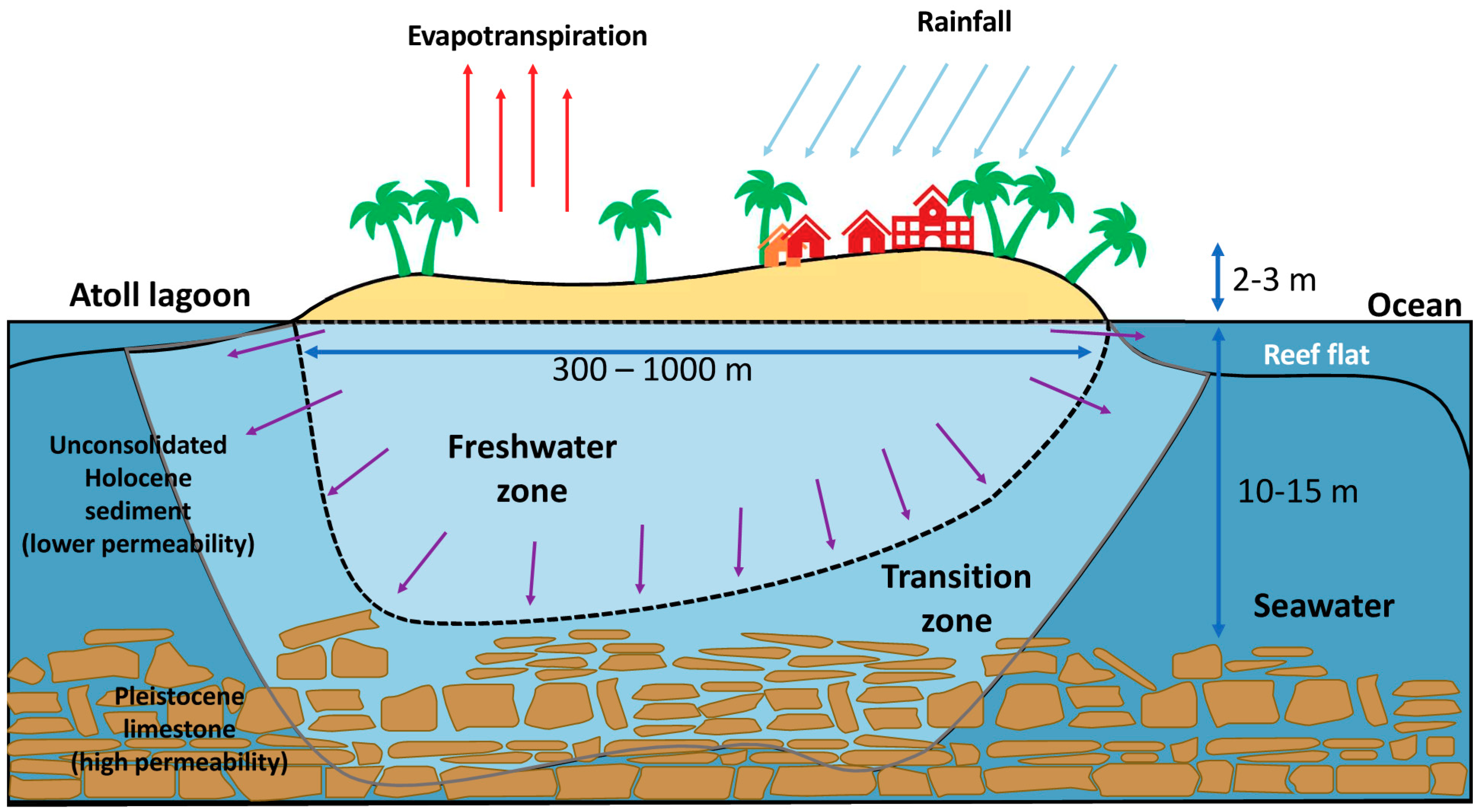
An important reason for the vulnerability of groundwater in coral islands like those of the Maldives is the fact that their bedrock is made of carbonate rock (Pleistocene limestone,
Figure 1), which is susceptible to dissolution in rainwater creating karst landforms. These are highly permeable due to the presence of organized networks of open fractures, karst conduits, and caves in the subsurface [
5] and facilitate contaminant transport [
6,
7,
8], particularly saltwater intrusion, increasing the fragility of the aquifer. The soil of these islands typically contains Holocene sediments, which comprises a mix of sands, coral fragments, and organic matter. Unaltered Holocene sediments (Coral sands) are moderately permeable [
9] but lose permeability due to cementation. Groundwater occurs as a thin “freshwater lens” over seawater in coral island aquifers (
Figure 1). This shallow freshwater lens is fed by rainwater recharge through the coral sands and is in a dynamic equilibrium depending on the level of recharge [
4].
Inhabited coral atoll islands are among landforms in which groundwater assessment is a crucial requirement for sustainable management of their water resources. However, a comprehensive assessment of groundwater quality and quantity, while being useful, is an expensive task [
10]. Due to the dispersed nature and relatively small size of islands in SIDS, expensive logistical processes and a large amount of equipment are needed to conduct such surveys. Therefore, it is useful to have inexpensive screening methods to conduct a rough assessment of groundwater to decide where the expensive, comprehensive assessments should focus on. In this paper, we propose such a methodology based on crowd-sourced information through social surveys. This is enabled in the case of inhabited islands of Maldives because of a large fraction of the population extract groundwater from wells for (non-potable) domestic use.
The Maldives has 1192 coral islands distributed over 26 atolls, but only a total of about 300 square kilometers of dry land. There are about 188 inhabited islands, where, except for the capital Malé (population 334,023) and several other large population centers (e.g., Addu, Kulhudhuhfushi and Fuvahmulah), the typical population of an island range from several hundred to several thousand [
11]. The total population of the country was 407,660 during the 2014 census and is estimated to be 974,359 as of 2054 [
12]. In many cases, these populations are concentrated in small landmasses resulting in high population densities. There are no rivers and streams in the Maldives except for a few mangroves and wetlands [
13]. Groundwater occurs in thin basal aquifers [
13] and lies 1–1.5 m below the surface [
4]. Traditionally Maldivians used groundwater from household wells for both potable and non-potable purposes [
13]. Rainwater harvesting for drinking began in 1978 largely as a response to a cholera outbreak. The first municipal water supply project began in the capital Malé in 1985 which was commissioned and begun its services in 1995. Including Malé and other population centers, 49% of the total population had access to piped water with metered house connections by the end of 2017. Many outer island populations depend on harvested rainwater for domestic use. Due to the increasing climate variability, among other reasons, the harvested rainwater stores run out during the dry season with increasing frequency [
14], resulting in an increased reliance on expensive, emergency water supply from population centers. SIDS like the Maldives are projected to have increasing aridity and resulting stress on freshwater resources under many climate scenarios [
15]. Such changes could significantly influence the demography of the country [
16]. The government of the Maldives has pledged to provide a piped water supply for all the inhabited islands [
17]. However, the infrastructure work needed to achieve this is expensive and time-consuming. At least until the water supply is provided, the groundwater remains an important and essential resource for island populations. Even after the realization of the total water supply coverage in the future, this resource would continue to provide important alternative and supplementary resources and deliver many ecosystem services. In some islands agriculture, and hence the food security would also depend on the sustainable management of groundwater resources.
Many of the outer islands of the Maldives do not have sewerage networks and proper waste management facilities, are highly populated, and consist of infrastructure services (e.g., powerhouses), industries (e.g., boatyards, ice plants, community-scale fish factories) and, in some cases, agricultural activities that potentially pollute the natural water system. It is suspected that the groundwater quality in many islands has deteriorated due to these factors. The outer islands of the Maldives experience drinking water shortages during the dry season. Annually, around 67 islands across the Maldives are provided with desalinated water by boats since the 2004 tsunami. The key problems of freshwater security relate to the increasingly variable rainfall patterns induced by climate change and sea-level rise induced salinity of groundwater. In response to this climate challenge, the Green Climate Fund (GCF) funded, five-year project, titled “Supporting vulnerable communities in the Maldives to manage climate change-induced water shortages” was started with a total budget of USD 28 million (referred to as GCF-Project). The objective is to deliver safe and secure freshwater to 105,000 people in the islands of the Maldives in the face of climate change risks. The project identifies groundwater as an important resource in ensuring water security and therefore has the improvement of groundwater quality to secure freshwater reserves for long term resilience as one of the objectives. The project is executed by the Ministry of Environment (MoE) together with the United Nations Development Programme (UNDP). Notwithstanding some anecdotal evidence of some random studies being available, no large-scale, systematic studies have been done to examine the groundwater situation in the outer islands of the Maldives. As the first step in addressing this knowledge gap, a social survey on the groundwater quality perception and use was conducted covering 45 inhabited islands. This paper presents the results of that study. The survey was part of a larger assessment carried out by the Ministry of Environment to design improved rainwater harvesting systems for the outer islands impacted by dry season water scarcity, under the GCF-Project. The objective of the current study was twofold: Firstly to test and validate the applicability of survey-based, crowdsourced data for screening groundwater quality in data-scarce environments like the outer islands of the Maldives. Secondly, to use the results of the screening to guide a more detailed, hydrogeological/geochemical analysis of the groundwater, which is the next stage of this investigation.
Recent literature has seen an increased use of a broad methodology commonly referred to as “citizen science”. Eitzel et al. [
18] identify two “strands” of citizen science: The first emphasizes the responsibility of science to society, which can be called “democratic” citizen science and the second, “participatory” citizen science, is the practice in which people mostly contribute observations or efforts to the scientific enterprise. The methodology adopted in this paper falls under the latter category. However, in the current research design, community participation is employed as “human sensors” and the consolidation and interpretation of the findings were done by scientists. Therefore, we use the term “crowd-sourcing” as a term to describe an open call to a wide group to aid in some kind of labor (First appeared in an article of WIRED magazine in 2006) [
18]. Azhoni and Goyal [
19] used an interview-based approach to ascertain the level of climate change awareness and the concerns and perspectives of a broad range of stakeholders of climate adaption of agriculture in Sikkim, India. The results demonstrated that there is limited awareness of climate change impacts among farmers but higher awareness among government officials in the key government departments indicating the need to narrow the gap of the understanding amount of different stakeholders. Re [
20] coined the term “socio-hydrogeological investigation” to describe the combined use of traditional groundwater assessment with participatory activities. For example, in a groundwater quality assessment in the Grombalia region in Tunisia, they employed both hydrogeochemical assessment and structured questionnaires and the latter found to provide useful information supporting the hydrogeochemical analysis [
21].
The following section presents the methodological details of the study. Then the important findings are described. These include the various uses of groundwater by inhabitants, the perceived groundwater quality, and the treatment approaches used at the household level. After that, we present the relationships among different water-use, quality, and treatment variables as well as the relationship of perceived water quality to external variables like geographic location, area of the landmass, and demography. Then we discuss the implications of those findings and finally, conclusions are presented.
2. Methodology
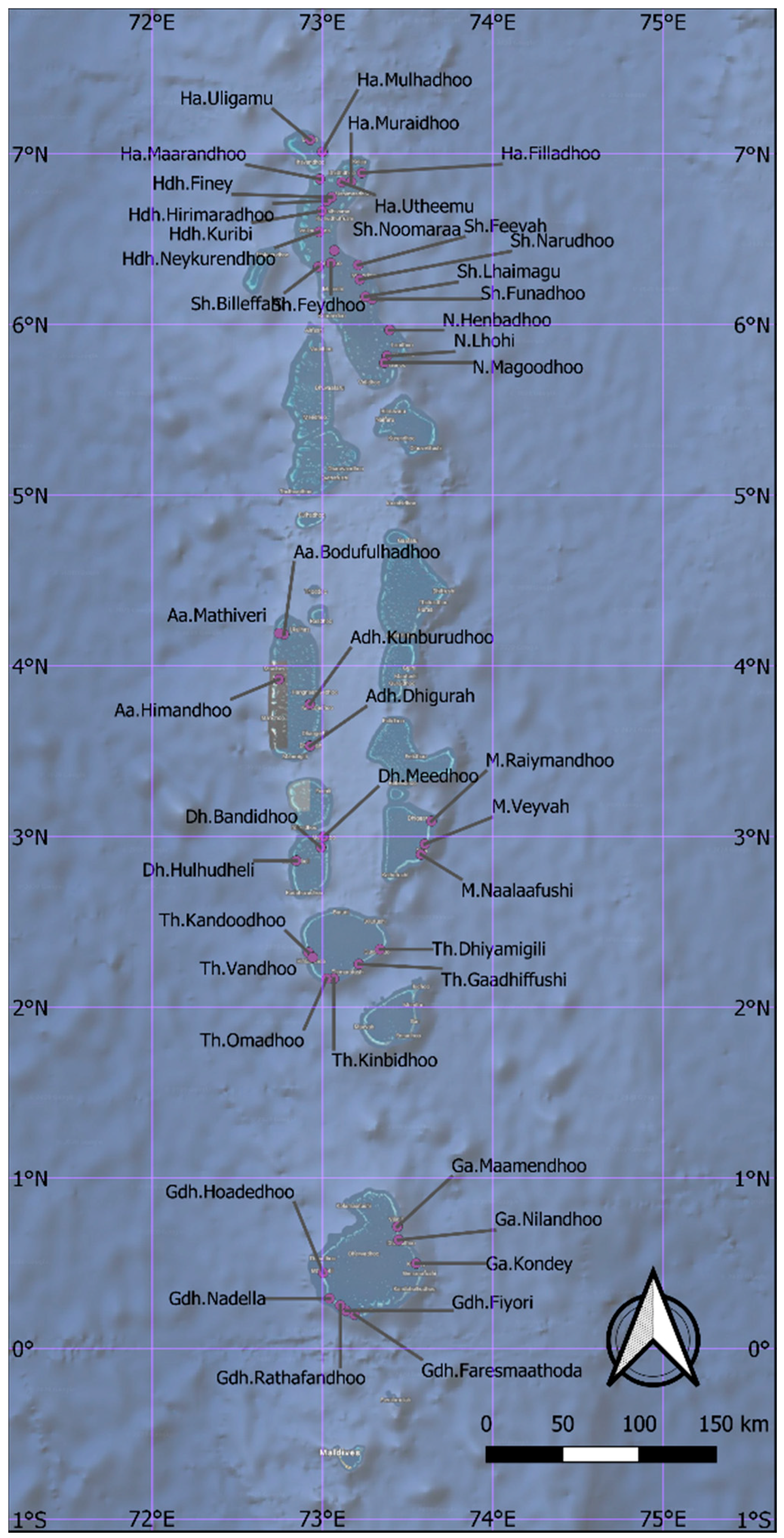
The selection of islands for the GCF-Project was primarily based on the vulnerability of the water supply during the dry period, as indicated by dry-season water emergency water supply requests. Within that list, the islands that have ongoing water supply projects as of 2014 were omitted, resulting in a final list of 45 islands. All of these were included in the current study (
Figure 2).
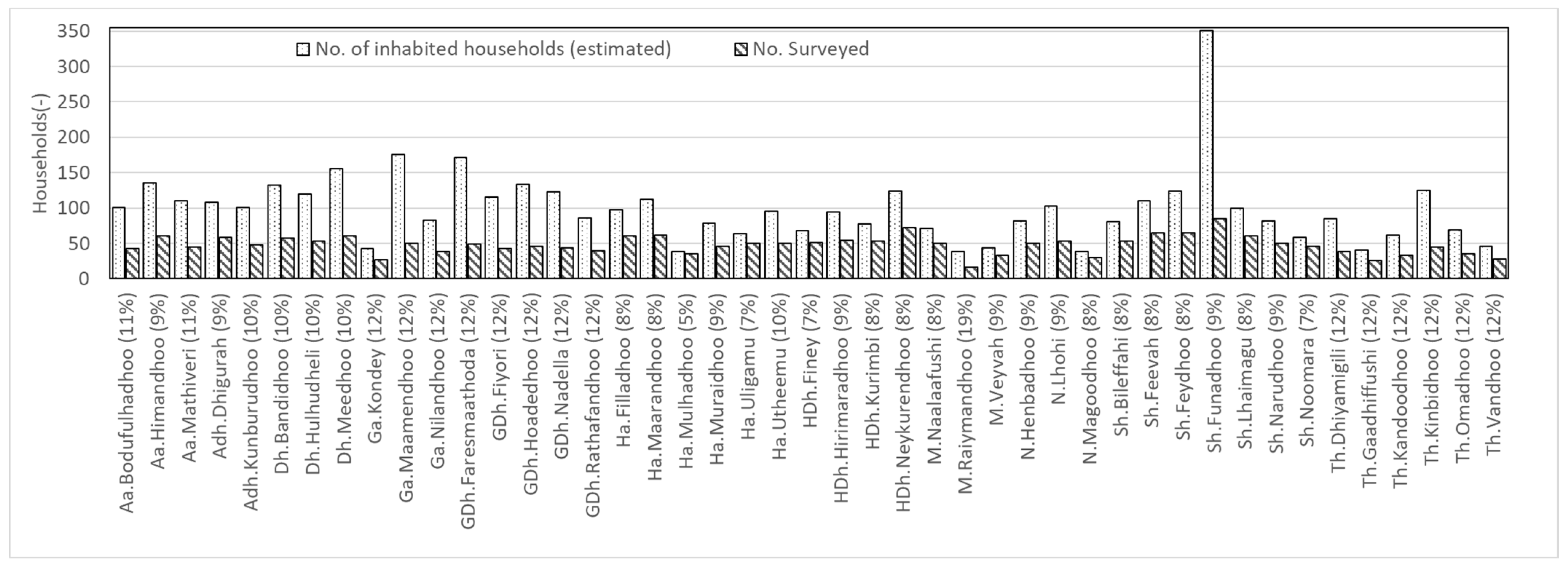
All the islands have areas less than 125 Ha, except two (Ha. Filladhoo and HDh.Neykurendhoo, 261 Ha and 169 Ha respectively) and a median population density of 11 inhabitants/Ha. Due to the small size, moderately high population density, and lack of fertile soil, agriculture is not practiced at a significant level. The social survey focused on household wells and did not include any agricultural wells.
During the year 2017 (September), a quantitative, structured questionnaire was administered face to face on all of the 45 islands. All of the questions were designed to be undertaken at the nominal (Yes/No) level of measurement. The main topics of the questionnaire were groundwater use, perceived groundwater quality, and current practices on groundwater treatment at the household level. The survey was carried out simultaneously by three separate teams due to the large spatial area covering 11 atolls. Each team consisted of one to two surveyors from the study team. Volunteers from each island were selected to assist with the works and were trained in administering the questionnaire. The data was collected by face to face interviews done at the location of the households in the local language (Dhivehi) and the responses were recorded directly on paper by the surveyors.
As a common practice, some families from inhabited islands migrate to the capital, Malé, for education, employment, and other such essential needs, many of the island councils did not have an exact figure of inhabited households at the time of the survey. Hence, it was assumed that all households are occupied by families of six members, which is a typical value for this demography. The total numbers of registered households were taken from the Island Council register. The sample size of each island was dictated by practical considerations like the availability of respondents in each household during the time of the survey. The maximum margin of error estimated at
p = 0.5, with a confidence interval of 95% ranged between 5 to 19% for individual islands (
Figure 3) and <2% for the total sample (all 45 islands) (This is also known as the specific margin of error. It is the largest possible value of Margin of Error (because it is calculated for
p = 0.5). In this paper, we have used the terms like
p-value, the margin of error, statistical significance, etc. These terms are defined with relevant links with examples in the online
Supplementary Materials, Table S1).
The whole survey took about 3 weeks, with each team covering a group of islands in the designated area. After the survey concluded, all the data on questionnaires were entered into the computer and further data processing was carried out with the statistical software JASP [
23] which uses the statistical analysis system R [
24] as its backend.
3. Results
This section describes the results of the social survey and is presented in three sections, which are: groundwater use, perceived groundwater quality, and practices of groundwater treatment. After that, we present the correlations among different variables in the survey as well as with some external parameters. Additional results that are not directly discussed here are provided as
Supplementary Materials. Figures S1 and S2, Tables S2–S22.
3.1. Groundwater Use
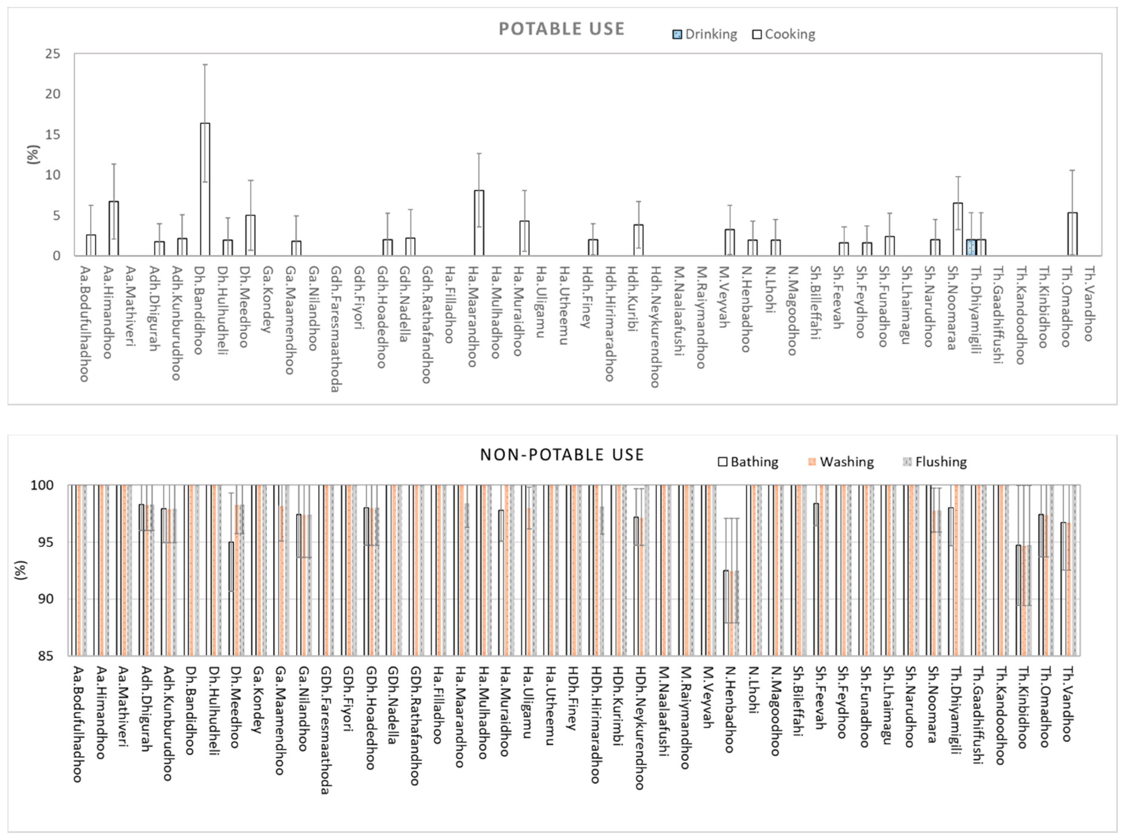
The groundwater use for potable purposes, which includes the uses of drinking and cooking, as well as non-potable use of groundwater—bathing, washing, and toilet flushing, were included in the survey.
Figure 4 shows the distribution of percentages of respondents that used groundwater for different purposes throughout the 45 islands.
All respondents noted that they do not use groundwater for drinking except one respondent from Th.Dhiyamigili. As for cooking, a few respondents in 24 islands informed us that they use groundwater for cooking purposes. Furthermore, it is noted that the usage of groundwater for cooking is considerably high in the island of Dh.Bandidhoo (49% of households). Almost all the respondents used groundwater for bathing, washing, and flushing of toilets.
3.2. Perceived Groundwater Quality
Figure 5 shows the distribution of the water quality perception in the 45 islands surveyed. Due to the different sample and population sizes, the margins of error differ for each island. These are shown as error bars.
The presence of odor in groundwater is generally high with a median value of 28.6% of respondents experiencing odor in groundwater per island. The islands Aa.Mathiveri, Dh.Meedhoo, Sh.Feevah, Th.Gaadhiffushi, Th.Kinbidhoo and Th.Dhiyamigili, have recorded 70% or more respondents experiencing odor in groundwater, out of which the most severe case is recorded for Th. Gaadhifushi with a value of 91%. Except for Ha.Maarandhoo, all the islands recorded the presence of varying degrees of odor. However, 17 of these islands recorded a percentage of 10 or lower.
Thirty-eight islands (84%) recorded varying degrees of salinity perception. Aa.Himandhoo, ADh.Kunburudhoo and GDh. Fiyoary recorded the highest percentages of 65%, 81% and 67% respectively. Ga. Kondey, Ha.Filladhoo, Ha.Uligam, Sh.Feydhoo, Sh.Noomara, Sh.Bilehfahi and Th.Vandhoo recorded no cases of salinization. Overall 11.3% (median) of households reported salinization in groundwater.
Groundwater in its pure form is clear and colorless, however, respondents of 41 islands have observed color in groundwater. The islands of Sh. Feevah, Th.Gaadhiffushi and Th. Kinbidhoo, have recorded the highest percentages of coloration, 80%, 72%, and 67% respectively. Overall 13.0% (median) of households reported coloration of groundwater from the selected 45 islands.
Respondents from 31 islands have noted the presence of particles (debris) in groundwater. Overall 5.0% (median) of respondents from each island have reported the presence of debris. The highest count was recorded for the islands of Sh.Feevah and Th.Kinbidhoo, 59%, and 47% respectively (Note: Sh.Feevah is a densely vegetated island with rich soil).
3.3. Groundwater Treatment Practices
In terms of treatments adopted for groundwater, two methods were identified from the survey, boiling and chlorine disinfection (methods identified by the respondents). However, it is important to note that generally, the practice of treating groundwater at the household level was not the norm in the outer islands.
The island with the highest responses for boiling groundwater was Aa. Himandhoo, where 28% of respondents informed us that they boil groundwater before use. Respondents from another 13 islands also informed that they practice this method for treating groundwater. However, the number of households employing this practice was very few from each island as it ranged from 1 to 8 respondents per island. Respondents from the rest of the 31 islands informed us that they do no practice boiling as a treatment of groundwater. It was noted from the interviews that the practice of boiling groundwater was used mostly for the bathing of infants and young children.
It was found that households from 20 islands practiced chorine disinfection as a treatment of groundwater by adding chlorine bleach to the wells. The highest percentage of respondents using chlorine disinfection was noted from Aa.Bodufulhudhoo, ADh.Dhigurah and Ga.Kondey, which was 15.4%, 10.3%, and 12.9% respectively.
3.4. Correlations
The acquired data from the social survey was assessed for significant correlations with other survey variables as well as influencing parameters such as those describing geographic features of the islands, demography, hydrometeorology, and dry period water supply.
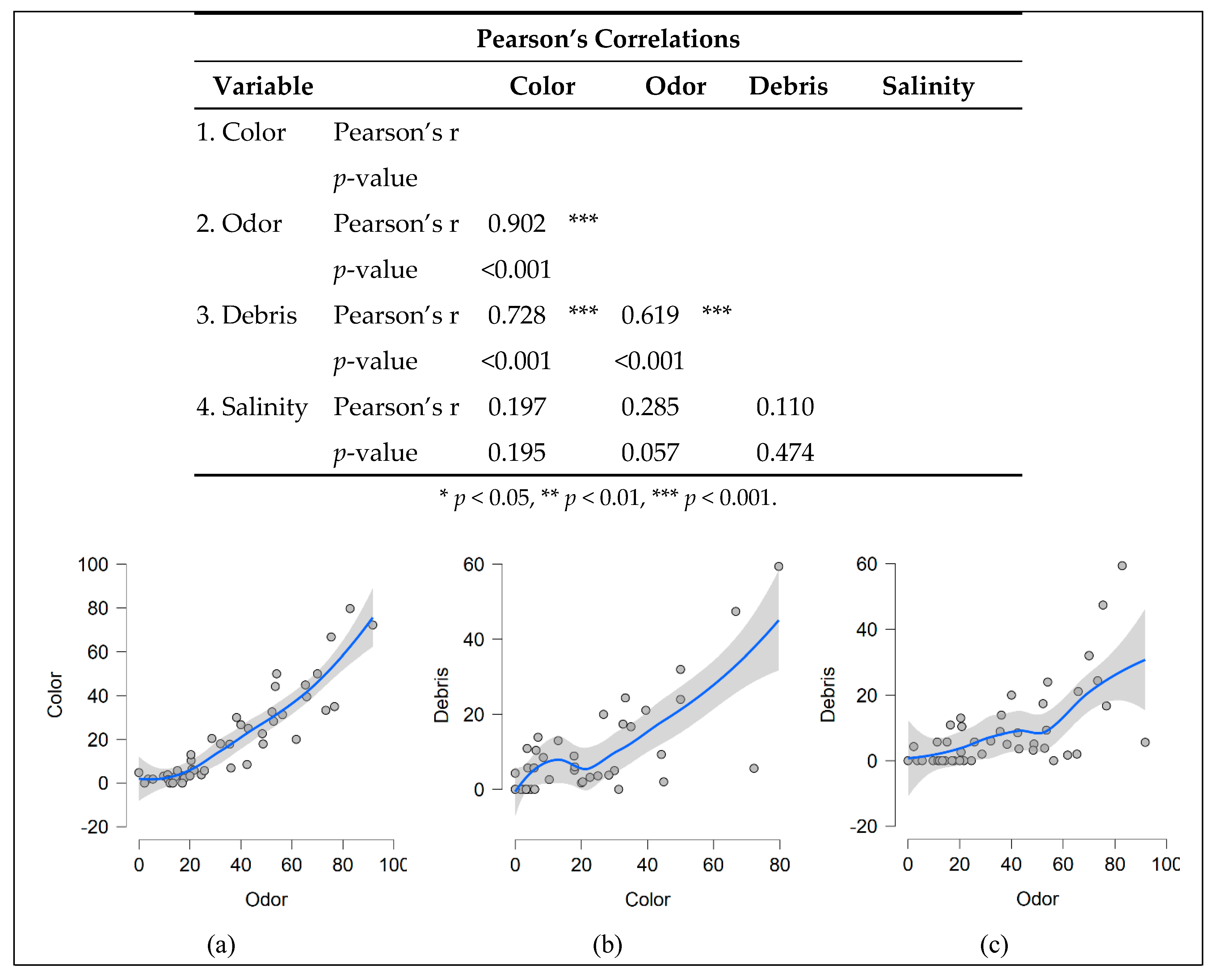
Firstly, the correlations among the groundwater quality parameters were examined. Percentages reporting the presence of odor, color and debris in each island were significantly (
p < 0.001%) correlated to each other (
Figure 6). There is no significant correlation between Salinity and the other variables.
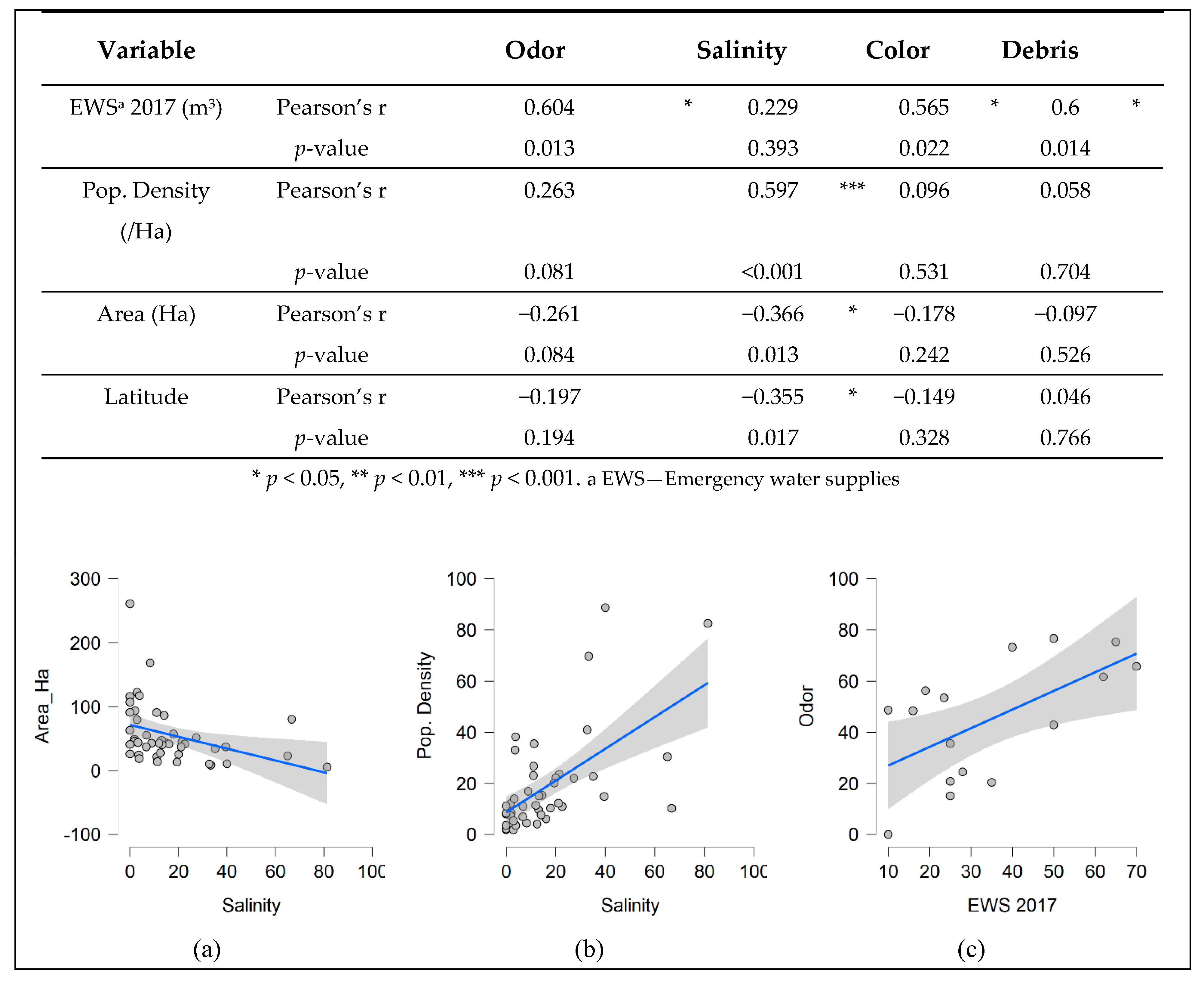
As the survey was undertaken in 2017, correlations between perceived groundwater quality and the quantity of dry period water supplied in the same year were assessed. As shown from
Figure 7 there are statistically significant (
p < 0.05), positive correlations between the quantity of dry period emergency water supplied in 2017 (EWS 2017) and the presence of odor, color, and debris in groundwater. No correlations were noted for salinity and dry period water supply.
The perceived groundwater quality parameters were assessed for correlations with geographic features of the survey islands such as latitude and the land area of the island (
Figure 6). It was found that there is a significant (
p < 0.05), negative correlation between the perceived salinity and the island’s latitude and area. Furthermore, it is noted that no other perceived groundwater quality parameters showed a significant correlation with the assessed geographic features of the islands.
A significant positive correlation is seen between the perceived groundwater salinity and population density (
Figure 6) based on the 2014 census. No significant correlations exist for odor, color change, and presence of debris in groundwater with the population density [
25,
26] of the islands.
The correlations between the perceived groundwater quality and communicable diseases were assessed (
Table 1); the results showed a significant, positive correlation between perceived salinity and diarrhea. The other diseases which were assessed were viral fever and acute respiratory infections, which showed no significant correlations with the recorded parameters of perceived groundwater quality.
4. Discussion
The traditional potable water source of the Maldives is harvested rainwater. While urban communities like those of Malé and other urban populated places like Fuvahmulah City, Addu City, Kulhudhuffushi City, Ha. Dhidhdhoo and GDh.Thinadhoo are using desalinated seawater as the main water source, many outer islands still rely on the harvested rainwater and prefer it over groundwater. This is very much confirmed by the results of the survey. Almost no island (with an exception of one household in Th.Dhiyamigili) use groundwater for drinking. Use for cooking is much more widespread, but, still a distinct minority. Only islands with that fraction above 5% outside the margin of error are Dh.Bandidhoo (16 ± 6%), Ha.Maarandhoo (8 ± 3%) and Sh.Noomaraa (7 ± 1%) out of the total 45 islands. It may be because the perceived groundwater quality is generally high in these islands in comparison to others. For example, odor in these islands is significantly less than those of the others (Student’s-t = 2.3, p = 0.01). Since all the 45 islands did not have piped water systems, the only alternative for potable use remains to be harvested rainwater. Once the harvested rainwater runs out, the islands must depend on emergency water supplies.
Even with relatively high annual rainfall amounts (about 2500 mm in the north to 3800 mm in the south), due to the limited storage capacity at households [
27], the challenge of rainwater storage limits its utility to the most important (potable) uses. All outer islands use groundwater for non-potable uses of bathing, washing, and flushing of toilets. The lack of the practice of boiling groundwater before use can be explained largely by using it only for non-potable uses. Again, this is confirmed by the current study with all 45 islands showing nearly 100% of respondents using groundwater for non-potable use. Henbadhoo of the northern atoll of Noonu shows the minimum fraction among all islands, which still is 93(±3)%.
A large fraction of islands (38) recorded their groundwater as having elevated salinity. The relatively small size of the islands (median 43 ha) leading to a very shallow groundwater lens and high population densities (average 1900, median 1100 inhabitants/km2) resulting in severely reduced groundwater recharge levels and a high level of extraction can explain this. The presence of odor and color in the groundwater may be largely related to the fact that many of these islands currently do not have networked sewer systems, but poorly maintained household septic tanks, resulting in groundwater pollution by wastewater, are a widespread occurrence. Moreover, in most households, the groundwater wells and the septic tanks are nearby of each other, further exacerbating the problems of groundwater pollution. The presence of color, odor, and debris is significantly (p < 0.001), positively correlated. This is to be expected as pollution of water sources can lead to the occurrence of color, odor, and particles in the water. Salinity is not expected to be related to these parameters as it is indicative of seawater intrusion and depletion of the freshwater lenses that are related to factors like the size of the island and its population density. The quantity and quality of the groundwater lens depend on three broad factors, namely, the rainfall regime that impacts the recharge rate, anthropogenic influences (that impacts recharge rates, abstraction rates, and the pollution) and the interaction with the ocean that influences the salinity. As expected, salinity shows a strong positive correlation with the population density (p < 0.001) and a significant negative correlation (p < 0.05) with the area of the island.
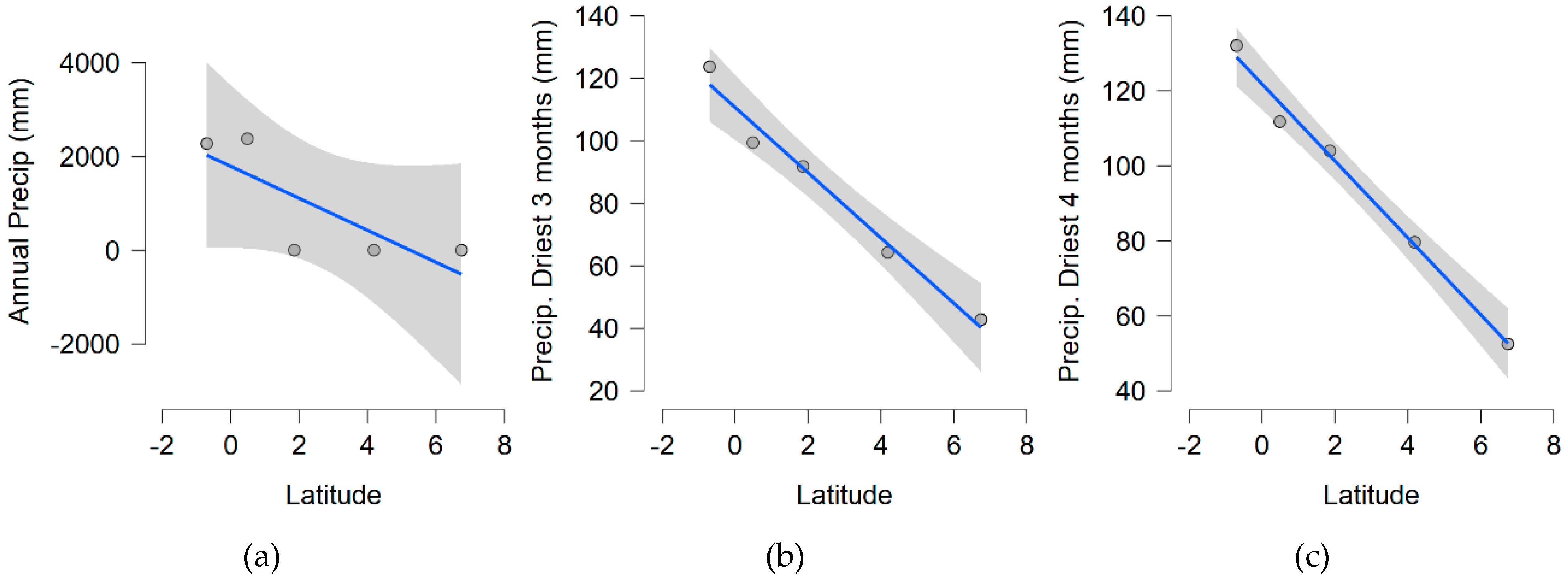
Relating the groundwater to rainfall proved to be difficult as many of the islands do not have rain gauges. However, it is a well-known fact that in the Maldives, the rainfall varies significantly from North to South with South recording higher annual rainfalls (around 3800 mm) as opposed to the North (about 2500 mm). Due to the nature of the surface hydrological processes, the rainfall distribution is also expected to have a high influence on the groundwater recharge. Rainfall that is spread over time is more conducive to infiltration (therefore groundwater recharge) than concentrated rainfall. The five locations Hdh. Hanimaadhoo, Male, L. Kadhdhoo, Gdh.Kaadedhoo and S.Gan, have airports that have collected rainfall records over a long period (about 30 years).
Figure 8 shows the negative linear relationship observed between the latitude and annual precipitation. Stronger correlations exist between the latitude and precipitation during driest 3 or 4 month periods.
This relationship shows that the amount of rainfall (particularly during dry months) decreases significantly in a northerly direction. According to the standard hydrological understanding, this should indicate a positive relationship between salinity and the latitude (salinity increase with increasing latitude). However, the current data shows an opposite, significant (p = 0.05%) correlation. Currently, we do not have a satisfactory explanation for this counterintuitive trend. It must be further studied. However, we speculate that physical processes, such as land-cover, ground slope, soil-type, and subsurface hydro-geological features might have a much stronger influence on the salinity than just the rainfall. Also, we do not attempt to explain the relationship between the occurrence of diarrhea and the salinity of the water. However, the results of this strong correlation are presented with the hope that in future studies on communicable disease, this direction would be further examined.
Assessment of the groundwater resources is traditionally done by sampling from existing groundwater wells. However, assessing groundwater quality by taking samples from existing wells, in most cases, does not show the representative quality of the groundwater lens on that island. Hence, groundwater surveys have been recently done using drilled boreholes. While this provides the “gold-standard” for groundwater investigations, it is often expensive and complicated to be deployed broadly. This is particularly the case with outer islands of the Maldives where small communities occupying small landmasses are distributed in hundreds of islands. GCF-Project has conducted a detailed groundwater assessment of ten islands selected from the 45 included in the current study. The findings are being finalized and will be the subject of a future article. Such an investigation has a cost of around 4000 USD per single island, making it difficult to be deployed for all the inhabited islands, especially at multiple points in time. Therefore, we believe that there is a need to integrate technical (e.g., hydrochemical monitoring with boreholes) and social (screening surveys) approaches to achieve a reliable understanding of the hydrological/hydrogeological scenario to use to make decisions on the management of groundwater resources at a large scale (e.g., multiple islands). The results of this study have contributed to the selection of ten islands for further detailed study of the groundwater situation. As such, the criteria for the island selection were guided by the significant correlations found in the current study such as island size, population density, and spatial coverage with the inclusion of additional parameters (such as land reclamation, presence of mangrove and critical infrastructure that have large catchment areas).
The success of using crowd-sourced information for groundwater screening encourages the broader application of citizen-science in the environmental data collection in the Maldives. All the inhabited islands in the country have mobile data reception and therefore mobile data access. This provides an excellent context to engage inhabitants in continuous monitoring of natural resources like groundwater, harvested rainwater quality, flood monitoring, coral reef health monitoring, etc. Ideally, it is perhaps optimal to mix the two strands of citizen science in such applications covering not only the participatory aspects of citizen science but also democratizing the sciences [
18]. In such contexts it is not difficult to deploy the same method for, for example, monitoring groundwater quantity (water table); providing simple gauges for the community and training them how to read them and report as an example can be done. On the other hand, the proposed screening approach has some clear shortcomings as well. For example, it is not possible to identify harmful contaminants like Arsenic (and many other heavy metals) or traces of pesticides, merely from the perception of the communities. The detection is limited by what can be readily perceived. However, providing cheap, simple equipment liking testing strips to communities can enable such tests [
28].
Currently, the Maldivian government has an ambitious plan to provide piped water supply to all the inhabited islands [
17] within the next three or four years. The main water source is planned to be desalinated seawater mixed with harvested and treated rainwater. However, the groundwater resources of these islands that are of critical importance today and would remain relevant even after achieving these targets. Groundwater could be used as an alternative source, easing the burden on the piped water supply. The Maldivian government is also promoting agriculture in the outer islands [
17] and groundwater would be an important resource for that ambition as well. Furthermore, it can also act as an important insurance policy for emergencies like non-functioning of the piped water system due to breakdowns and natural disasters, etc. Therefore, sustaining the groundwater resource is an important policy priority for the Maldives. This includes a baseline assessment of the quantity and quality of groundwater in the inhabited islands and implementing monitoring schemes to observe the changes in those parameters. Currently, there are many initiatives to establish groundwater monitoring facilities in some islands. For example, GCF project has done groundwater assessment in 13 islands (including 10 islands from the current study) and has plans to establish groundwater monitoring facilities. However, the sheer number of inhabited islands in the country makes it necessary to have alternative means of screening groundwater quantity and quality as well. The proposed crowd-sourced method can function as (a) a screening tool to identify the critically important monitoring locations for further study and (b) to augment the borehole-based observations in time and space for example for widespread monitoring.
The global warming-induced sea-level rise (SLR) is threatening the Maldives in many ways. SLR would negatively impact the freshwater lens and would increase the salinity of the groundwater. The best possible observational data on such dynamic phenomena can be obtained with frequent and geographically spread sampling approaches. The current study was a one-time survey, providing a snapshot of groundwater quality indicators in-time. However, this method can be used to detect temporal changes in groundwater quality and quantity as well as other environmental parameters. Used alongside well-selected (but a usually limited number of) continuous monitoring stations, such data can be valuable in understanding the full picture of the climate impacts on small islands.
5. Conclusions
Crowd-sourcing scientific information has been widely used as a means of achieving higher sampling densities for environmental monitoring. We deployed a household-level social survey in 45 selected islands of the Maldives to assess the groundwater use and screen the quality of the groundwater, based on human perception. The results indicate that it is practical to use crowd-sourced methodologies like the one described to assess the groundwater quality. Beyond the described use (single deployment) such methods can also be recommended for continuous deployment, for example, using mobile phone-based information collection.
The current study reveals some interesting patterns related to the groundwater system in the Maldives. In many inhabited islands, groundwater is adversely impacted by anthropogenic influences, namely, lessening the recharge capacity, unsustainable use, and pollution due to wastewater. The majority of islands report color, odor, and particles in groundwater indicating the widespread nature of this pollution. The presence of salinity in the groundwater indicates a quantity problem—the issue of low recharge and high use of groundwater, which is exacerbated by climate change-driven sea-level rise as well as variability and change in the rainfall. Thirty-eight out of 45 islands reporting salinity in the water indicates the adverse impact of these on the size of the freshwater lens. A clear positive relationship of salinity with annual and dry-season rainfall is observed, but it is difficult to explain this with the intuitive understanding of the hydrological processes and therefore should be studied further.
Moreover, there is scope to improve on the current crowd-sourced methodology by collecting relevant data on household practices such as the maintenance of groundwater wells and septic tanks, island-specific agricultural practices, infrastructure allocation within house plots (distance between the septic tank and the groundwater well) and existing practices of stormwater or excess rainwater management to compare with the perceived groundwater quality. There is a possibility that these types of social assessments to reveal proven household-level practices in groundwater improvement which could be mainstreamed by the relevant awareness programs to the rest of the nation. Alongside detailed hydrogeochemical investigations at selected locations, we believe crowd-sourced data gathering remains relevant in completing the big-picture of the state and dynamics of the groundwater in the context of a rapidly changing environment.


