
Landscape Pattern Change of Impervious Surfaces and Its Driving Forces in Shanghai during 1965–2010


Abstract
:1. Introduction
2. Study Area and Methods
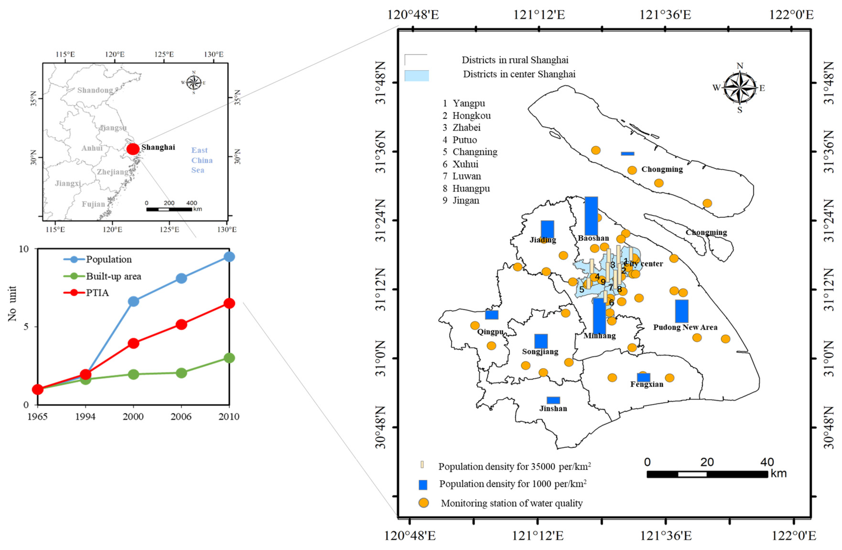
2.1. Study Area and Data
2.2. Methods
2.2.1. Definition of Impervious Surfaces Based on Land Uses
2.2.2. Methodology
3. Results
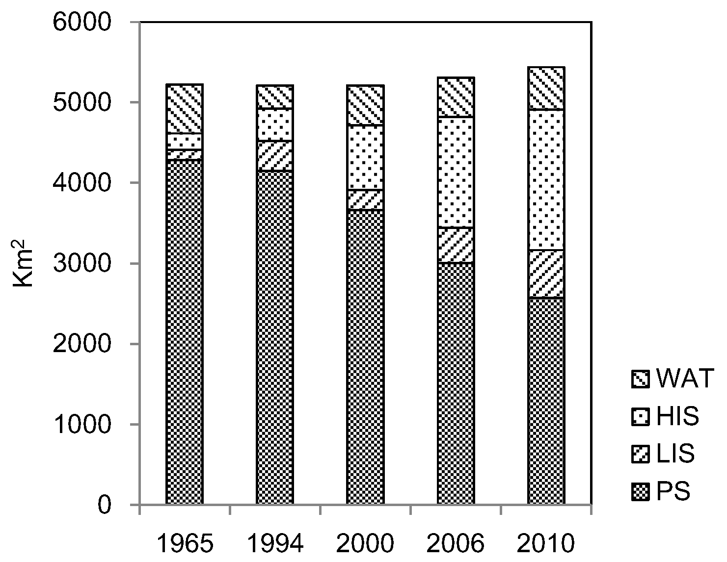
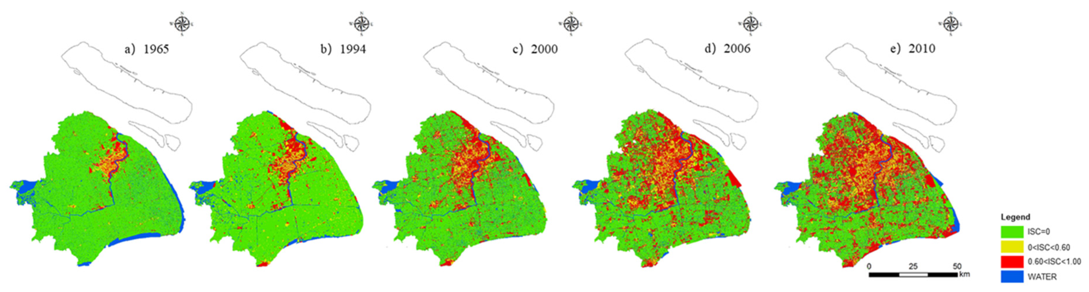
3.1. Composition of Different Impervious Surfaces Changed
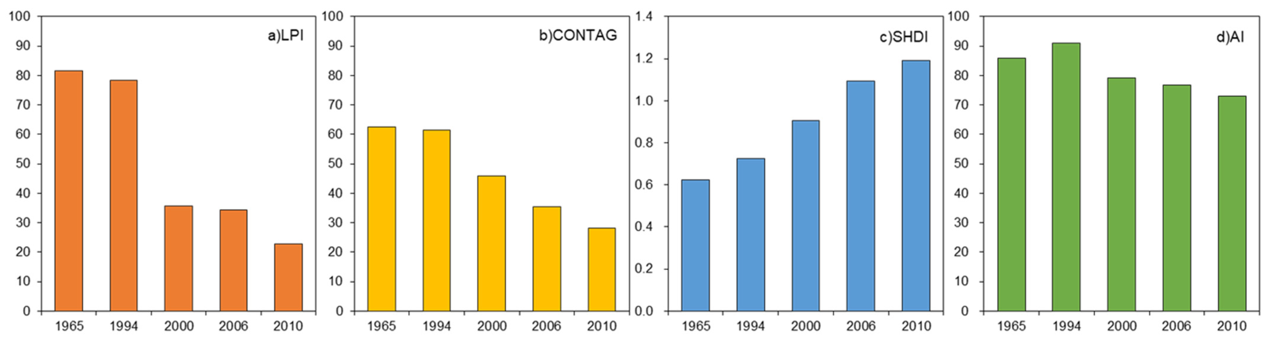
3.2. Fragmentation and Diversity of Impervious Surface Patches Increased
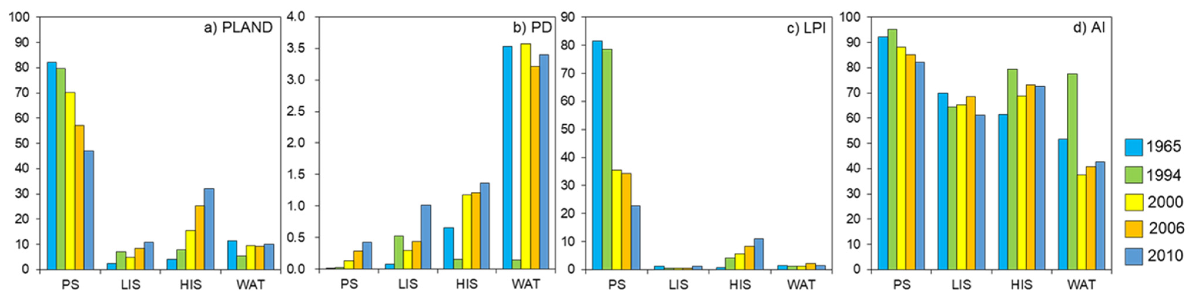
3.3. Landscape Pattern Change of Different Impervious Surfaces
3.3.1. Pervious Surfaces Continuously Reduced and Its Fragmentation Increased
3.3.2. Low Impervious Surfaces Expanded, but Have a Tendency to Disperse
3.3.3. High Impervious Surfaces Grew Dramatically, and the LPI Increased
3.3.4. Change of Water Area Is Not Significant
3.4. The Driving Forces of Landscape Pattern Change
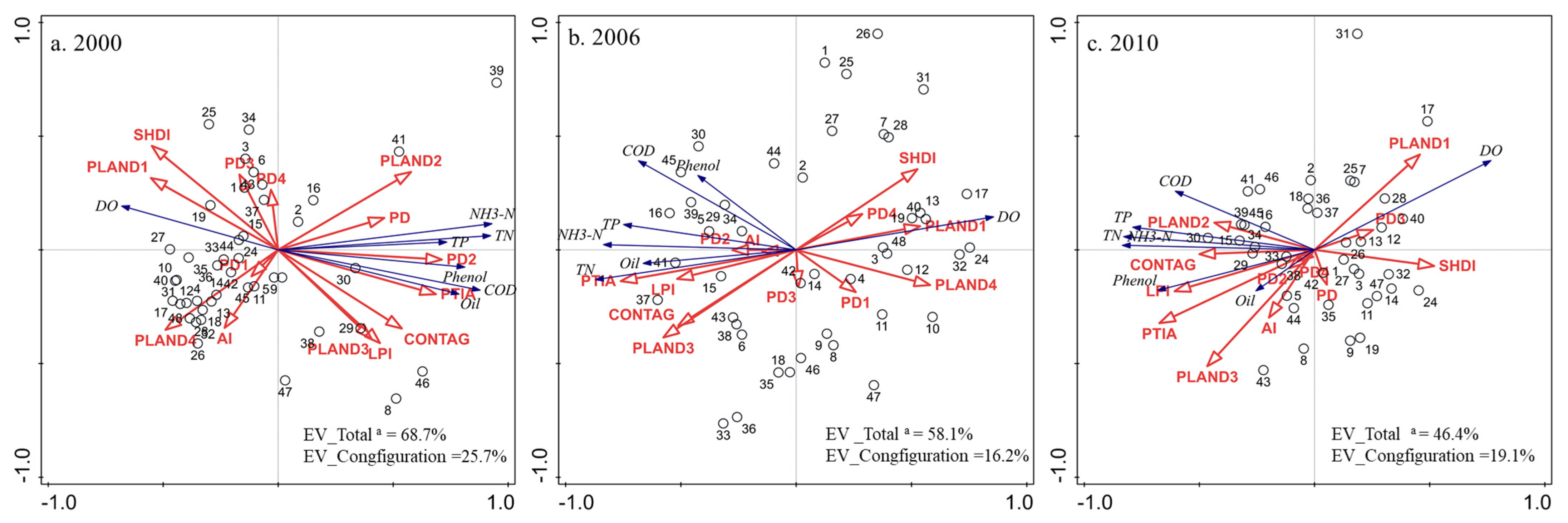
3.5. Influence of Landscape Metrics on Water Quality
4. Discussion
4.1. Comparison with Previous Research
4.2. The Primary Driving Forces Are Population Density and Unit Area GDP
4.3. Influence of Urbanization on Landscape Metrics
4.4. Policy Implications
4.5. Limitations
4.5.1. Selection of Landscape Metrics
4.5.2. Application of the Impervious Surface Coefficients
4.5.3. Different Sources of Remote Sensing Images
5. Conclusions
Author Contributions
Funding
Institutional Review Board Statement
Informed Consent Statement
Data Availability Statement
Acknowledgments
Conflicts of Interest
Abbreviations
| ISC | Impervious surface coefficient |
| PTIA | Percentage of Total Impervious Area |
| PLAND | Percentage of Landscape |
| PLAND1 | Percentage of Landscape of Pervious Surface |
| PLAND2 | Percentage of Landscape of Low impervious surfaces |
| PLAND3 | Percentage of Landscape of High Im2pervious Surfaces |
| PLAND4 | Percentage of Landscape of Water |
| LPI | Largest Patch Index |
| PD | Patch Density |
| PD1 | Patch Density of Pervious Surfaces |
| PD2 | Patch Density of Low impervious surfaces |
| PD3 | Patch Density of High impervious surfaces |
| PD4 | Patch Density of Water |
| SHDI | Shannon Diversity Index |
| AI | Aggregation Index |
| CONTAG | Contagion Index |
| POP_D | Population Density |
| GDP | Gross Domestic Product |
| UAGDP | Unit Area GDP |
| PPI | Percentage of Primary Industry |
| PSI | Percentage of Secondary Industry |
| PTI | Percentage of Tertiary Industry |
| DO | Dissolved Oxygen |
| COD | The Chemical Oxygen Demand |
| TN | Total Nitrogen |
| TP | The Total Phosphorus |
| NH3–N | Un-ionized Ammonia |
References
- Akter, T.; Quevauviller, P.; Eisenreich, S.J.; Vaes, G. Impacts of climate and land use changes on flood risk management for the Schijn River, Belgium. Environ. Sci. Policy 2018, 89, 163–175. [Google Scholar] [CrossRef]
- Aulenbach, B.T.; Landers, M.; Musser, J.W.; Painter, J.A. Effects of Impervious Area and BMP Implementation and Design on Storm Runoff and Water Quality in Eight Small Watersheds. JAWRA J. Am. Water Resour. Assoc. 2017, 53, 382–399. [Google Scholar] [CrossRef]
- Bailey, D.; Herzog, F.; Augenstein, I.; Aviron, S.; Billeter, R.; Szerencsits, E.; Baudry, J. Thematic resolution matters: Indicators of landscape pattern for European agro-ecosystems. Ecol. Indic. 2007, 7, 692–709. [Google Scholar] [CrossRef]
- Bierwagen, B.G.; Theobald, D.M.; Pyke, C.R.; Choate, A.; Groth, P.; Thomas, J.V.; Morefield, P. National housing and impervious surface scenarios for integrated climate impact assessments. Proc. Natl. Acad. Sci. USA 2010, 107, 20887–20892. [Google Scholar] [CrossRef] [Green Version]
- Nagy, R.C.; Lockaby, B.G.; Kalin, L.; Anderson, C.J. Effects of urbanization on stream hydrology and water quality: The Florida Gulf Coast. Hydrol. Process. 2012, 26, 2019–2030. [Google Scholar] [CrossRef]
- Chen, S.; Shen, S.; Chen, L.; Lu, G. Test of engineering properties of impervious soil with salt. Adv. Technol. Water Resour. 2015, 35, 66–70. [Google Scholar]
- Chithra, S.; Nair, M.H.; Amarnath, A.; Anjana, N. Impacts of impervious surfaces on the environment. Int. J. Eng. Sci. Invent. 2015, 4, 2319–6726. [Google Scholar]
- Cui, X.; Wang, X. Urban land use change and its effect on social metabolism: An empirical study in Shanghai. Habitat Int. 2015, 49, 251–259. [Google Scholar] [CrossRef]
- Deng, C.; Wu, C. BCI: A biophysical composition index for remote sensing of urban environments. Remote Sens. Environ. 2012, 127, 247–259. [Google Scholar] [CrossRef]
- Edwards, A.W.F.; Cavalli-Sforza, L.L. A Method for Cluster Analysis. Biometrics 1965, 21, 362. [Google Scholar] [CrossRef]
- Feng, S.S.; Fan, F.L. Spatiotemporal changes of landscape pattern using impervious surface in Guangdong-Hong Kong-Macao Greater Bay Area, China. Chin. J. Appl. Ecol. 2018, 29, 2907–2914. [Google Scholar]
- Fu, B.-J.; Zhao, W.-W.; Chen, L.-D.; Liu, Z.-F.; Lu, Y.-H. Eco-hydrological effects of landscape pattern change. Landsc. Ecol. Eng. 2005, 1, 25–32. [Google Scholar] [CrossRef]
- Fu, B.; Peng, Y.; Zhao, J.; Wu, C.; Liu, Q.; Xiao, K.; Qian, G. Driving forces of impervious surface in a world metropolitan area, Shanghai: Threshold and scale effect. Environ. Monit. Assess. 2019, 191, 771. [Google Scholar] [CrossRef]
- Han, L.; Xu, Y.; Yang, L.; Deng, X.; Hu, C.; Xu, G. Temporal and spatial change of stream structure in Yangtze River Delta and its driving forces during 1960s–2010s. Acta Geogr. Sin. 2015, 70, 819–827. [Google Scholar]
- Jacobson, C.R. Identification and quantification of the hydrological impacts of imperviousness in urban catchments: A review. J. Environ. Manag. 2011, 92, 1438–1448. [Google Scholar] [CrossRef] [PubMed]
- Jat, M.K.; Garg, P.K.; Khare, D. Monitoring and modelling of urban sprawl using remote sensing and GIS techniques. Int. J. Appl. Earth Obs. Geoinf. 2008, 10, 26–43. [Google Scholar] [CrossRef]
- Jin-hua, R.; Shao-hua, W.; Sheng-lu, Z.; Chen, L. Advances in Remote Sensing Research on Urban Impervious Surface. Remote Sens. Land Resour. 2012, 24, 8–15. [Google Scholar]
- Karamizadeh, S.; Abdullah, S.M.; Manaf, A.A.; Zamani, M.; Hooman, A. An Overview of Principal Component Analysis. J. Signal Inf. Process. 2013, 4, 173–175. [Google Scholar] [CrossRef] [Green Version]
- Kim, H.; Jeong, H.; Jeon, J.; Bae, S. The Impact of Impervious Surface on Water Quality and Its Threshold in Korea. Water 2016, 8, 111. [Google Scholar] [CrossRef] [Green Version]
- Lee, C.; Kim, K.; Lee, H. GIS based optimal impervious surface map generation using various spatial data for urban nonpoint source management. J. Environ. Manag. 2018, 206, 587–601. [Google Scholar] [CrossRef] [PubMed]
- Lee, S.-W.; Hwang, S.-J.; Lee, S.-B.; Hwang, H.-S.; Sung, H.-C. Landscape ecological approach to the relationships of land use patterns in watersheds to water quality characteristics. Landsc. Urban Plan. 2009, 92, 80–89. [Google Scholar] [CrossRef]
- Li, J.; Li, C.; Zhu, F.; Song, C.; Wu, J. Spatiotemporal pattern of urbanization in Shanghai, China between 1989 and 2005. Landsc. Ecol. 2013, 28, 1545–1565. [Google Scholar] [CrossRef]
- Li, M.; Zang, S.; Wu, C.; Na, X. Spatial and temporal variation of the urban impervious surface and its driving forces in the central city of Harbin. J. Geogr. Sci. 2018, 28, 323–336. [Google Scholar] [CrossRef] [Green Version]
- Liu, C.; Shao, Z.; Chen, M.; Luo, H. MNDISI: A multi-source composition index for impervious surface area estimation at the individual city scale. Remote Sens. Lett. 2013, 4, 803–812. [Google Scholar] [CrossRef]
- Liu, Z.; Li, Y.; Peng, J. Progress and perspective of the research on hydrological effects of urban impervious surface on water environment. Prog. Geogr. 2011, 30, 275–281. [Google Scholar]
- Luo, Y.; Zhao, Y.; Yang, K.; Chen, K.; Pan, M.; Zhou, X. Dianchi Lake watershed impervious surface area dynamics and their impact on lake water quality from 1988 to 2017. Environ. Sci. Pollut. Res. 2018, 25, 29643–29653. [Google Scholar] [CrossRef]
- McGarigal, K.; Marks, B.J. FRAGSTATS: Spatial pattern analysis program for quantifying landscape structure. PNW-GTR-351. Portland, OR: U.S. Department of Agriculture, Forest Service, Pacific Northwest Research Station. Gen. Tech. Rep. 1995, 122, 351. [Google Scholar]
- Qi, W.; Qu, Y.-b.; Liu, H.-y.; Li, L. Selection of representative landscape pattern indexes and land use division. China Land Sci. 2009, 23, 33–37. [Google Scholar]
- Ridd, M.K. Exploring a V-I-S (vegetation-impervious surface-soil) model for urban ecosystem analysis through remote sensing: Comparative anatomy for cities. Int. J. Remote Sens. 1995, 16, 2165–2185. [Google Scholar] [CrossRef]
- Romero-Calcerrada, R.; Perry, G.L. The role of land abandonment in landscape dynamics in the SPA ‘Encinares del río Alberche y Cofio, Central Spain, 1984–1999. Landsc. Urban Plan. 2004, 66, 217–232. [Google Scholar] [CrossRef]
- Salerno, F.; Gaetano, V.; Gianni, T. Urbanization and climate change impacts on surface water quality: Enhancing the resilience by reducing impervious surfaces. Water Res. 2018, 144, 491–502. [Google Scholar] [CrossRef]
- Sherard, J.L. A Current Review of Experience with Asphaltic Concrete Impervious Membranes on the Upstream Slope of Earth and Rockfill Dams. In Embankment Dams: James L. Sherard Contributions; ASCE: Reston, VA, USA, 1992; pp. 10–29. [Google Scholar]
- Song, M.; Du, J.; Zheng, W.; Li, C.; Biao, G. Quantifying the spatial-temporal changes of impervious surface landscape pattern from 1988 to 2015 in Qinhuai River Basin. J. Geo-Inf. Sci. 2017, 19, 238–247. [Google Scholar]
- Tang, J.; Di, L.; Rahman, S.; Yu, Z. Spatial–temporal landscape pattern change under rapid urbanization. J. Appl. Remote Sens. 2019, 13, 024503. [Google Scholar] [CrossRef]
- Uygun, B.Ş.; Albek, M. Determination effects of impervious areas on urban watershed. Environ. Sci. Pollut. Res. 2014, 22, 2272–2286. [Google Scholar] [CrossRef]
- Verbeiren, B.; Van De Voorde, T.; Canters, F.; Binard, M.; Cornet, Y.; Batelaan, O.; Verbeiren, B.; Van De Voorde, T.; Canters, F.; Binard, M.; et al. Assessing urbanisation effects on rainfall-runoff using a remote sensing supported modelling strategy. Int. J. Appl. Earth Obs. Geoinf. 2013, 21, 92–102. [Google Scholar] [CrossRef]
- Wang, W.; Yao, X.; Ji, M.; Zhang, J. Spectral data treatments for impervious endmember derivation and fraction mapping from Landsat ETM+ imagery: A comparative analysis. Front. Earth Sci. 2015, 9, 179–191. [Google Scholar] [CrossRef]
- Wang, Z.; Zhang, S.; Peng, Y.; Wu, C.; Lv, Y.; Xiao, K.; Zhao, J.; Qian, G. Impact of rapid urbanization on the threshold effect in the relationship between impervious surfaces and water quality in shanghai, China. Environ. Pollut. 2020, 267, 115569. [Google Scholar] [CrossRef]
- Wu, C.; Murray, A.T. Estimating impervious surface distribution by spectral mixture analysis. Remote Sens. Environ. 2003, 84, 493–505. [Google Scholar] [CrossRef]
- Xian, G.; Homer, C. Updating the 2001 National Land Cover Database Impervious Surface Products to 2006 using Landsat Imagery Change Detection Methods. Remote Sens. Environ. 2010, 114, 1676–1686. [Google Scholar] [CrossRef]
- Xiao, J.; Liu, X.; Ji, N.; Yu, L. Study on the Change of Landscape Pattern of Shijiazhuang City in the Process of Rapid Urbanization. J. Southwest China Norm. Univ. Nat. Sci. 2014, 39, 149–155. [Google Scholar]
- Yang, K.; Yuan, W.; Zhao, J.; Xu, S. Stream structure characteristics and its urbanization responses to tidal river system. Acta Geogr. Sin. 2004, 59, 557–564. [Google Scholar]
- Zhou, Z.-L.; Sha, J.-M.; Fan, Y.-X.; Shuai, C.; Gao, S. Temporal and spatial variations of impervious surface landscape pattern and the driving factors in Xiamen City, China. Chin. J. Appl. Ecol. 2020, 31, 230–238. [Google Scholar]


| Land Use Type | ISC | Sample Size | Standard Deviation | Reclassification of Impervious Surfaces | Combination of Land Use Types | Interval Range of ISC |
|---|---|---|---|---|---|---|
| Park green space | 0.33 | 20 | 14.12 | Low impervious surfaces | New residential, villas, parks | 0–60% |
| villa | 0.49 | 30 | 10.82 | 0–60% | ||
| New residential | 0.55 | 30 | 9.64 | 0–60% | ||
| Public buildings | 0.64 | 20 | 11.03 | High impervious surfaces | Old residential, public building, industrial land, road and square | 60–100% |
| Old residential | 0.73 | 30 | 10.36 | 60–100% | ||
| Industrial land | 0.75 | 20 | 11.95 | 60–100% | ||
| Road and square, roofs | 1.00 | / | / | 60–100% | ||
| / | / | / | / | Pervious surface | Agricultural land, natural village | 0 |
| / | / | / | / | Water | Rivers, lakes | / |
| Types | Landscape Metrics | Abbreviation | Ecological Meaning | Calculation Formula |
|---|---|---|---|---|
| Area | Percentage of Landscape | PLAND | The ratio of the area of a particular type of patch to the total area of the regional landscape | |
| Largest Patch Index | LPI | The ratio of the largest patch in the same type of patch to the total area of this type of patch | ||
| density | Patch Density | PD | Reflect the degree of fragmentation of the landscape and the degree of spatial heterogeneity of the landscape | |
| Shannon Diversity Index | SHDI | Reflects the change in the number of landscape elements and the proportion of each landscape element. When the landscape is composed of a single element, its value is 0 | SHDI = | |
| Gathering | Aggregation Index | AI | The ratio of the number of adjacent public sides of a landscape type grid to the maximum possible number of public sides between the grids of this type of landscape, which represents the degree of aggregation of the type of landscape | AI = |
| Contagion Index | CONTAG | Describe the degree of agglomeration of different types of patches in the landscape. The larger the value, the larger the landscape is composed of a few large clusters, and the smaller it is composed of many scattered small patches. | CONTAG = |
| Order | District | PS (%) | LIS (%) | HIS (%) | WAT (%) | PD | CONTAG | SHDI |
|---|---|---|---|---|---|---|---|---|
| 1 | Average | 36.0358 | 22.0342 | 35.0286 | 6.9014 | 12.7312 | 41.4283 | 0.9974 |
| 2 | Baoshan | 52.9339 | 16.1899 | 23.8687 | 7.0076 | 10.0282 | 27.7171 | 1.1597 |
| 3 | Fengxian | 76.4006 | 5.6739 | 11.3865 | 6.5389 | 6.7728 | 48.1139 | 0.7942 |
| 4 | Huangpu | 0.2216 | 19.9943 | 69.2707 | 10.5134 | 16.3485 | 60.0208 | 0.8265 |
| 5 | Jiading | 60.6294 | 10.4614 | 20.9815 | 7.9277 | 9.3539 | 29.7429 | 1.0681 |
| 6 | Jinshan | 79.1254 | 4.6228 | 10.2912 | 5.9607 | 5.0435 | 52.1657 | 0.7295 |
| 7 | Jingan | 0.3228 | 32.5468 | 66.6594 | 0.4711 | 27.2628 | 63.8487 | 0.6794 |
| 8 | Luwan | 0.4088 | 28.4314 | 65.2797 | 5.88 | 22.9346 | 59.6815 | 0.8251 |
| 9 | Minhang | 48.5804 | 17.8723 | 25.9988 | 7.5485 | 4.7871 | 24.5934 | 1.2037 |
| 10 | Pudong | 54.9473 | 11.3881 | 23.2103 | 10.4543 | 2.3304 | 24.9218 | 1.1515 |
| 11 | Putuo | 22.1126 | 38.458 | 36.6143 | 2.8151 | 19.6043 | 34.0858 | 1.1696 |
| 12 | Qingpu | 64.2581 | 5.6646 | 11.486 | 18.5913 | 3.2748 | 34.743 | 1.0082 |
| 13 | Songjiang | 69.1375 | 10.9177 | 12.3459 | 7.5989 | 4.5653 | 40.522 | 0.9511 |
| 14 | Xuhui | 9.918 | 36.4003 | 47.1942 | 6.4875 | 19.6795 | 37.29 | 1.1289 |
| 15 | Yangpu | 15.3587 | 30.9553 | 45.1743 | 8.5117 | 13.1258 | 36.1203 | 1.2194 |
| 16 | Zhabei | 17.9483 | 39.1993 | 40.8339 | 2.0185 | 20.986 | 40.9064 | 1.1199 |
| 17 | Changning | 4.2689 | 43.7712 | 49.8624 | 2.0974 | 17.6012 | 48.3799 | 0.9243 |
| POP_D | GDP | UAGDP | PPI | PSI | PTI | |
|---|---|---|---|---|---|---|
| PS (%) | −0.938 ** | −0.146 | −0.684 ** | −0.666 ** | −0.859 ** | −0.886 ** |
| LIS (%) | −0.789 ** | −0.185 | −0.371 | −0.609 ** | −0.749 ** | −0.775 ** |
| HIS (%) | −0.951 ** | −0.162 | −0.776 ** | −0.580 * | −0.868 ** | −0.886 ** |
| WAT (%) | −0.388 | −0.341 | −0.016 | −0.041 | −0.429 | −0.407 |
| PD | −0.913 ** | −0.385 | −0.542 * | −0.541 * | −0.858 ** | −0.873 ** |
| CONTAG | −0.332 | −0.523 * | −0.371 | −0.503 * | −0.377 | −0.313 |
| SHDI | −0.049 | −0.411 | −0.089 | −0.698 ** | −0.071 | −0.001 |
Publisher’s Note: MDPI stays neutral with regard to jurisdictional claims in published maps and institutional affiliations. |
© 2021 by the authors. Licensee MDPI, Basel, Switzerland. This article is an open access article distributed under the terms and conditions of the Creative Commons Attribution (CC BY) license (https://creativecommons.org/licenses/by/4.0/).
Share and Cite
Yao, Y.; Zhang, S.; Shi, Y.; Xu, M.; Zhang, J.; Zhang, Y.; Zhao, J. Landscape Pattern Change of Impervious Surfaces and Its Driving Forces in Shanghai during 1965–2010. Water 2021, 13, 1956. https://doi.org/10.3390/w13141956
Yao Y, Zhang S, Shi Y, Xu M, Zhang J, Zhang Y, Zhao J. Landscape Pattern Change of Impervious Surfaces and Its Driving Forces in Shanghai during 1965–2010. Water. 2021; 13(14):1956. https://doi.org/10.3390/w13141956
Chicago/Turabian StyleYao, Yang, Sen Zhang, Yuqing Shi, Mengqi Xu, Jiaquan Zhang, Yongming Zhang, and Jun Zhao. 2021. "Landscape Pattern Change of Impervious Surfaces and Its Driving Forces in Shanghai during 1965–2010" Water 13, no. 14: 1956. https://doi.org/10.3390/w13141956
APA StyleYao, Y., Zhang, S., Shi, Y., Xu, M., Zhang, J., Zhang, Y., & Zhao, J. (2021). Landscape Pattern Change of Impervious Surfaces and Its Driving Forces in Shanghai during 1965–2010. Water, 13(14), 1956. https://doi.org/10.3390/w13141956