Hydrochemical Characterisation of High-Fluoride Groundwater and Development of a Conceptual Groundwater Flow Model Using a Combined Hydrogeological and Hydrochemical Approach on an Active Volcano: Mount Meru, Northern Tanzania
Abstract
:1. Introduction
2. Materials and Methods
2.1. Study Area
2.1.1. Location, Topography, and Climate
2.1.2. Geological and Hydrogeological Setting
2.2. Inventory of Water Points
2.3. Sampling
2.4. Field Measurements
2.5. Laboratory Analysis
2.6. Data Processing and Analysis
3. Results and Discussion
3.1. Physicochemical Characteristics and Conceptual Groundwater Flow Model
3.2. Major and Minor Ions Origin
3.2.1. Eastern and Northeastern Flanks
3.2.2. Far East of the Eastern Flank (Northern Flank of Ngurdoto Crater)
3.2.3. Northwestern and Western Flanks
3.2.4. Southwestern Flank
4. Temporal Variability of Fluoride Concentrations and Precipitation/Recharge Values
5. Conclusions and Recommendations
Author Contributions
Funding
Institutional Review Board Statement
Informed Consent Statement
Data Availability Statement
Acknowledgments
Conflicts of Interest
References
- Pavelic, P.; Giordano, M.; Bernard, N. Groundwater Availability and Use in Sub-Saharan Africa: A Review of 15 Countries; International Water Management Institute: Colombo, Sri Lanka, 2012. [Google Scholar] [CrossRef] [Green Version]
- Mato, R.R.A.M. Groundwater Pollution in urban Dar es Salaam, Tanzania: Assessing Vulnerability and Protection Priorities. Ph.D. Thesis, Eindhoven University of Technology, Eindhoven, The Netherlands, 19 June 2002. [Google Scholar] [CrossRef]
- McKenzie, M.; Mark, B.G.; Thompson, L.G.; Schotterer, U.; Lin, P.N. A hydrogeochemical survey of Kilimanjaro (Tanzania): Implications for water sources and ages. Hydrogeol. J. 2010, 18, 985–995. [Google Scholar] [CrossRef]
- Ghiglieri, G.; Balia, R.; Oggiano, G.; Pittalis, D. Prospecting for safe (low fluoride) groundwater in the Eastern African Rift: The Arumeru District (Northern Tanzania). Hydrol. Earth Syst. Sci. 2010, 14, 1081–1091. [Google Scholar] [CrossRef] [Green Version]
- Ghiglieri, G.; Pittalis, D.; Cerri, G.; Oggiano, G. Hydrogeology and hydrogeochemistry of an alkaline volcanic area: The NE Mt. Meru slope (East African Rift—Northern Tanzania). Hydrol. Earth Syst. Sci. 2012, 16, 529–541. [Google Scholar] [CrossRef] [Green Version]
- Chacha, N.; Njau, K.N.; Lugomela, G.V.; Muzuka, A.N.N. Hydrogeochemical characteristics and spatial distribution of groundwater quality in Arusha well fields, Northern Tanzania. Appl. Water Sci. 2018, 8, 118. [Google Scholar] [CrossRef] [Green Version]
- Makoba, E.; Muzuka, A.N.N. Water quality and hydrogeochemical characteristics of groundwater around Mt. Meru, Northern Tanzania. Appl. Water Sci. 2019, 9, 120. [Google Scholar] [CrossRef] [Green Version]
- Mtoni, Y.; Mjemah, I.C.; Bakundukize, C.; Van Camp, M.; Martens, K.; Walraevens, K. Saltwater intrusion and nitrate pollution in the coastal aquifer of Dar es Salaam, Tanzania. Environ. Earth Sci. 2013, 70, 1091–1111. [Google Scholar] [CrossRef]
- Malago, J.; Makoba, E.; Muzuka, A.N.N. Fluoride levels in surface and groundwater in Africa: A review. Am. J. Water Sci. Eng. 2017, 3, 1–17. [Google Scholar] [CrossRef] [Green Version]
- World Health Organization (WHO). Guidelines for Drinking-Water Quality: Fourth Edition Incorporating the First Addendum; World Health Organization: Geneva, Switzerland, 2017; Available online: https://apps.who.int/iris/bitstream/handle/10665/254637/9789241549950-eng.pdf?sequence=1 (accessed on 12 February 2020).
- Nanyaro, J.T.; Aswathanarayana, U.; Mungure, J.S.; Lahermo, P.W. A geochemical model for the abnormal fluoride concentrations in waters in parts of northern Tanzania. J. Afr. Earth Sci. 1984, 2, 129–140. [Google Scholar] [CrossRef]
- Rango, T.; Bianchini, G.; Beccaluva, L.; Tassinari, R. Geochemistry and water quality assessment of central Main Ethiopian Rift natural waters with emphasis on source and occurrence of fluoride and arsenic. J. Afr. Earth Sci. 2010, 57, 479–491. [Google Scholar] [CrossRef]
- Haji, M.; Wang, D.; Li, L.; Qin, D.; Guo, Y. Geochemical evolution of fluoride and implication for F− enrichment in groundwater: Example from the Bilate River Basin of Southern Main Ethiopian Rift. Water 2018, 10, 1799. [Google Scholar] [CrossRef] [Green Version]
- Gaciri, S.; Davies, T. The occurrence and geochemistry of fluoride in some natural waters of Kenya. J. Hydrol. 1993, 143, 395–412. [Google Scholar] [CrossRef]
- Coetsiers, M.; Kilonzo, F.; Walraevens, K. Hydrochemistry and source of high fluoride in groundwater of the Nairobi area, Kenya / Hydrochimie et origine des fortes concentrations en fluorure dans l’eau souterraine de la région de Nairobi, au Kenya. Hydrol. Sci. J. 2008, 53, 1230–1240. [Google Scholar] [CrossRef]
- Gevera, P.; Mouri, H. Natural occurrence of potentially harmful fluoride contamination in groundwater: An example from Nakuru County, the Kenyan Rift Valley. Environ. Earth Sci. 2018, 77, 365. [Google Scholar] [CrossRef]
- Dibal, H.U.; Schoeneich, K.; Garba, I.; Lar, U.A.; Bala, E.A. Occurrence of fluoride in the drinking waters of Langtang area, north central Nigeria. Health 2012, 4, 1116–1126. [Google Scholar] [CrossRef] [Green Version]
- Kilham, P.; Hecky, R.E. Fluoride: Geochemical and ecological significance in East African waters and sediments. Limnol. Oceanogr. 1973, 18, 932–956. [Google Scholar] [CrossRef]
- Kitalika, A.J.; Machunda, R.L.; Komakech, H.C.; Njau, K.N. Fluoride variations in rivers on the slopes of Mount Meru in Tanzania. J. Chem. 2018, 2018, 7140902. [Google Scholar] [CrossRef] [Green Version]
- Delcamp, A.; Kervyn, M.; Benbakkar, M.; Kwelwa, S.; Peter, D. Large volcanic landslide and debris avalanche deposit at Meru, Tanzania. Landslides 2017, 14, 833–847. [Google Scholar] [CrossRef]
- NASA/METI/AIST/Japan Spacesystems, and U.S./Japan ASTER Science Team, 2011. ASTER Global Digital Elevation Model Version 2. NASA EOSDIS Land Processes DAAC. Available online: https://doi.org/10.5067/ASTER/ASTGTM.002 (accessed on 10 December 2017).
- Tanzania National Bureau of Statistics. 2012 Population and Housing Census: Population Distribution by Administrative Areas; Tanzania National Bureau of Statistics: Dar es Salaam, Tanzania, 2013; Available online: https://www.nbs.go.tz/nbs/takwimu/census2012/Census_General_Report.zip (accessed on 26 November 2020).
- Wilkinson, P.; Downie, C.; Cattermole, P.J.; Mitchell, J.G. Arusha, Geological Survey of Tanzania, Quarter Degree Sheet 55. 1983. Available online: https://library.wur.nl/WebQuery/file/isric/fulltext/isricu_i33425_001.pdf (accessed on 15 June 2017).
- Scoon, R.N. Arusha national park (Mount Meru). In Geology of National Parks of Central/Southern Kenya and Northern Tanzania; Springer: Cham, Switzerland, 2018; pp. 141–154. [Google Scholar] [CrossRef]
- Central Intelligence Agency (CIA). The World Factbook Book. Africa: Tanzania. Available online: https://www.cia.gov/the-world-factbook/countries/tanzania/locator-map (accessed on 15 June 2018).
- Wikipedia. Arusha Region. Available online: https://en.wikipedia.org/wiki/Arusha_Region (accessed on 15 June 2018).
- Kisaka, M.; Fontijn, K.; Shemsanga, C.; Tomašek, I.; Gaduputi, S.; Debaille, V.; Delcamp, A.; Kervyn, M. The late Quaternary eruptive history of Meru Volcano, Northern Tanzania. J. Volcanol. Geotherm. Res. 2021, 417, 107314. [Google Scholar] [CrossRef]
- American Public Health Association; American Water Works Association; Water Environment Federation. Standard Methods for the Examination of Water and Wastewater, 23rd ed.; American Public Health Association: Washington, DC, USA, 2017. [Google Scholar]
- Walraevens, K.; Bakundukize, C.; Mtoni, Y.E.; Van Camp, M. Understanding the hydrogeochemical evolution of groundwater in Precambrian basement aquifers: A case study of Bugesera region in Burundi. J. Geochem. Explor. 2018, 188, 24–42. [Google Scholar] [CrossRef]
- Piper, A.M. A graphical interpretation of water analysis. Trans. Am. Geophys. Union. 1944, 25, 914–928. [Google Scholar] [CrossRef]
- Tóth, J. A theoretical analysis of groundwater flow in small drainage basins. J. Geophys. Res. 1963, 68, 4795–4812. [Google Scholar] [CrossRef]
- Tóth, J. Groundwater as a geologic agent: An overview of the causes, processes, and manifestations. Hydrogeol. J. 1999, 7, 1–14. [Google Scholar] [CrossRef]
- Sawyer, G.M.; Carn, S.A.; Tsanev, V.I.; Oppenheimer, C.; Burton, M. Investigation into magma degassing at Nyiragongo volcano, Democratic Republic of the Congo. Geochem. Geophys. Geosyst. 2008, 9, Q02017. [Google Scholar] [CrossRef] [Green Version]
- Jasim, A.; Hemmings, B.; Mayer, K.; Scheu, B. Groundwater flow and volcanic unrest. In Volcanic Unrest. Advances in Volcanology; Gottsmann, J., Neuberg, J., Scheu, B., Eds.; Springer: Cham, Switzerland, 2018; pp. 83–99. [Google Scholar] [CrossRef] [Green Version]
- Fischer, T.P.; Arellano, S.; Carn, S.; Aiuppa, A.; Galle, B.; Allard, P.; Lopez, T.; Shinohara, H.; Kelly, P.; Werner, C.; et al. The emissions of CO2 and other volatiles from the world’s subaerial volcanoes. Sci. Rep. 2019, 9, 18716. [Google Scholar] [CrossRef] [PubMed] [Green Version]
- Bakundukize, C.; Mtoni, Y.E.; Van Camp, M.; Walraevens, K. Occurrences of evaporitic salts in Bugesera region (Burundi) and relation to hydrogeochemical evolution of groundwater. Environ. Earth Sci. 2018, 77, 223. [Google Scholar] [CrossRef]
- Tanzania Bureau of Standards (TBS). TZS 789:2008: Drinking (Potable) Water—Specification; Tanzania Bureau of Standards: Dar es Salaam, Tanzania, 2008. [Google Scholar]





| Type of Water Points | Number of Inventoried Points | Number of Sampled Points | % of Sampled Points | Number of Samples | Number of Samples per Water Point | Characteristic of Sampled Wells/Boreholes |
|---|---|---|---|---|---|---|
| Hand-dug wells | 104 | 66 | 63 | 86 | 3 points were sampled three times | Shallow wells |
| 14 points were sampled twice | ||||||
| 49 points were sampled once | ||||||
| Springs | 68 | 52 | 68 | 85 | 2 points were sampled five times | |
| 10 points were sampled three times | ||||||
| 5 points were sampled twice | ||||||
| 35 points were sampled once | ||||||
| Boreholes | 33 | 4 | 12 | 1 | Samples once | Shallow well |
| 3 | Each point sampled once | Deep wells |
| Water Type | pH | EC | Na+ | K+ | Ca2+ | Mg2+ | Fe2+/Fe3+ | Mn2+ | NH4+ | F− | Cl− | SO42− | NO3− | NO2− | (HCO3− + CO32−) * | PO43− | SiO2 | TDS | |
|---|---|---|---|---|---|---|---|---|---|---|---|---|---|---|---|---|---|---|---|
| Eastern flank | |||||||||||||||||||
| Springs (n = 16) | Min | 7.1 | 105 | 15.1 | 3.5 | 1.0 | 0.2 | 0.03 | 0.0 | 0.0 | 0.1 | 1.7 | 0.0 | 0.0 | 0.0 | 44.5 | 0.00 | 27.2 | 117 |
| Max | 8.6 | 1183 | 425 | 58 | 11.9 | 0.9 | 0.14 | 7.0 | 10 | 274 | 19 | 68 | 5.4 | 11 | 330 | 0.79 | 61.1 | 1184 | |
| Mean | 7.7 | 339 | 80 | 19.6 | 5.8 | 0.4 | 0.06 | 2.0 | 2.0 | 36.1 | 6.6 | 9.2 | 2.3 | 1.0 | 137 | 0.32 | 38.8 | 336 | |
| Median | 7.7 | 231 | 28.4 | 13.4 | 5.8 | 0.4 | 0.05 | 0.0 | 0.0 | 1.4 | 5.0 | 0.4 | 2.2 | 0.0 | 114 | 0.15 | 37.5 | 221 | |
| SD. | 0.4 | 327 | 131 | 16.6 | 3.6 | 0.2 | 0.03 | 3.0 | 3.0 | 89 | 4.8 | 23 | 1.3 | 3.0 | 82 | 0.33 | 7.6 | 333 | |
| CV (%) | 5 | 96 | 163 | 84 | 62 | 53 | 52 | 145 | 155 | 247 | 73 | 248 | 58 | 202 | 60 | 102 | 20 | 99 | |
| Hydrothermal springs (n = 2) | 8.2 | 3650 | 899 | 179 | 8.4 | 1.6 | 0.07 | 0.0 | 0.0 | 301 | 100 | 260 | 2.5 | 4.0 | 1287 | 0.00 | 31.4 | 3070 | |
| 8.5 | 4590 | 1123 | 216 | 3.8 | 2.3 | 0.04 | 6.0 | 16 | 95.2 | 148 | 418 | 0.9 | 0.0 | 2170 | 0.96 | 36.3 | 4214 | ||
| Stream (n = 1) | 9.1 | 4390 | 1140 | 220 | 9.1 | 2.2 | 0.06 | 0.0 | 0.0 | 553 | 295 | 377 | 1.1 | 0.0 | 914 | 0.79 | 27.6 | 3540 | |
| Lakes (n = 3) | Min | 9.5 | 8630 | 1928 | 283 | 5.7 | 1.5 | 0.12 | 1.0 | 0.0 | 217 | 192 | 10.4 | 5.1 | 3.0 | 4285 | 2.0 | 0.3 | 7438 |
| Max | 10.1 | 19820 | 5190 | 801 | 7.6 | 3.8 | 0.18 | 5.0 | 0.0 | 1004 | 512 | 517 | 7.1 | 51 | 9863 | 6.5 | 2.2 | 17495 | |
| Mean | 9.8 | 15340 | 3786 | 599 | 6.8 | 2.7 | 0.15 | 2.0 | 0.0 | 736 | 379 | 209 | 6.0 | 32 | 7811 | 3.5 | 1.1 | 13541 | |
| Median | 9.9 | 17570 | 4240 | 714 | 7.3 | 2.7 | 0.16 | 1.0 | 0.0 | 988 | 434 | 102 | 6.0 | 41 | 9285 | 2.0 | 0.9 | 15691 | |
| SD. | 0.3 | 5919 | 1678 | 277 | 1.0 | 1.1 | 0.03 | 2.0 | 0.0 | 450 | 167 | 270 | 1.0 | 25 | 3067 | 2.6 | 1.0 | 5362 | |
| CV (%) | 3 | 39 | 44 | 46 | 15 | 42 | 22 | 99 | 61 | 44 | 129 | 16 | 79 | 39 | 75 | 88 | 40 | ||
| Far east of the eastern flank (Northern flank of Ngurdoto crater) | |||||||||||||||||||
| Springs (n = 2) | 7.2 | 632 | 106 | 26.2 | 14.0 | 2.4 | 0.02 | 8.0 | 75 | 2.6 | 13.4 | 19.8 | 10.0 | 2.0 | 334 | 0.05 | 44.5 | 573 | |
| 7.6 | 919 | 171 | 42.8 | 2.4 | 0.4 | 0.02 | 12 | 38 | 10.7 | 3.3 | 25.7 | 23.5 | 78 | 478 | 0.60 | 30.8 | 789 | ||
| Shallow wells (n = 13) | Min | 7.1 | 487 | 58 | 17.7 | 3.0 | 0.4 | 0.00 | 0.0 | 0.0 | 1.0 | 3.6 | 3.4 | 0.0 | 0.0 | 186.0 | 0.00 | 38.4 | 506 |
| Max | 8.4 | 1932 | 443 | 60.1 | 28.9 | 7.1 | 36.4 | 300 | 67 | 133.7 | 26.3 | 68.7 | 101.1 | 1292 | 756 | 1.17 | 195 | 1644 | |
| Mean | 7.8 | 788 | 134 | 34.3 | 11.5 | 2.4 | 7.26 | 82 | 16 | 18.8 | 10.4 | 27.3 | 22.5 | 188 | 355.9 | 0.48 | 112 | 737 | |
| Median | 8.1 | 740 | 117 | 30.4 | 9.4 | 1.8 | 0.06 | 60 | 0.0 | 4.5 | 9.1 | 21.9 | 5.3 | 0.0 | 342.5 | 0.49 | 147 | 640 | |
| SD. | 0.5 | 381 | 100.0 | 14.0 | 7.8 | 1.8 | 11.9 | 96 | 23 | 36.7 | 5.7 | 18.1 | 31.6 | 457 | 143 | 0.39 | 64.7 | 294 | |
| CV (%) | 6 | 48 | 74 | 41 | 68 | 72 | 164 | 118 | 150 | 195 | 55 | 66 | 141 | 244 | 40 | 81 | 58 | 40 | |
| Water pond (n = 1) | 9.2 | 4310 | 789 | 268.5 | 25.7 | 5.7 | 0.20 | 19 | 45 | 85.9 | 62.1 | 254 | 5.9 | 126 | 1730 | 8.19 | 1.9 | 3237 | |
| North-eastern flank | |||||||||||||||||||
| Springs (n = 27) | Min | 6.9 | 292 | 58.7 | 8.1 | 1.3 | 0.4 | 0.00 | 0.0 | 0.0 | 3.0 | 2.3 | 4.9 | 2.1 | 0.0 | 151 | 0.00 | 15.6 | 276 |
| Max | 8.6 | 3510 | 1012 | 124 | 36.0 | 11.2 | 0.50 | 400 | 345 | 113 | 136 | 499 | 59.1 | 3731 | 1643 | 1.68 | 210 | 3560 | |
| Mean | 7.8 | 1809 | 393 | 58.8 | 13.8 | 4.1 | 0.08 | 37 | 67 | 30.0 | 44.7 | 169 | 15.9 | 280 | 820 | 0.44 | 65.6 | 1616 | |
| Median | 7.8 | 1205 | 224 | 49.4 | 12.2 | 3.5 | 0.06 | 3.0 | 11 | 12.5 | 18.4 | 58.3 | 11.3 | 2.0 | 716 | 0.21 | 48.2 | 1105 | |
| SD. | 0.5 | 1162 | 286 | 33.7 | 7.0 | 2.4 | 0.12 | 92 | 95 | 33.2 | 46.9 | 181 | 14.9 | 765 | 453 | 0.51 | 56.2 | 1002 | |
| CV (%) | 7 | 64 | 73 | 57 | 51 | 58 | 142 | 246 | 142 | 111 | 105 | 107 | 94 | 274 | 55 | 117 | 86 | 62 | |
| Shallow wells (n = 12) | Min | 7.6 | 424 | 80.4 | 12.4 | 2.7 | 0.3 | 0.02 | 0.0 | 0.0 | 3.6 | 3.8 | 1.9 | 0.0 | 0.0 | 220 | 0.00 | 24.2 | 412 |
| Max | 8.5 | 2680 | 579 | 80.9 | 11.7 | 6.4 | 30.8 | 2480 | 80 | 121 | 78.3 | 204 | 36.5 | 633 | 1080 | 1.36 | 160 | 2322 | |
| Mean | 8.0 | 1034 | 230 | 29.3 | 6.3 | 1.7 | 5.27 | 543 | 28 | 24.6 | 27.7 | 42.8 | 8.2 | 60 | 507 | 0.28 | 85.9 | 970 | |
| Median | 8.1 | 890 | 205 | 26.3 | 5.7 | 1.1 | 1.61 | 59 | 28 | 14.7 | 21.8 | 27.1 | 4.3 | 4.0 | 485 | 0.18 | 65.5 | 869 | |
| SD. | 0.4 | 551 | 121 | 17.5 | 2.7 | 1.6 | 9.68 | 877 | 26 | 31.1 | 19.3 | 52.9 | 10.2 | 181 | 202 | 0.39 | 54.1 | 465 | |
| CV (%) | 4 | 53 | 53 | 60 | 44 | 99 | 184 | 162 | 93 | 126 | 70 | 124 | 124 | 301 | 40 | 138 | 63 | 48 | |
| River (n = 1) | 8.8 | 1736 | 464 | 87.2 | 9.3 | 1.2 | 0.08 | 0.0 | 0.0 | 144 | 45.1 | 126 | 1.1 | 2.0 | 645 | 0.55 | 20.8 | 1544 | |
| North-western flank | |||||||||||||||||||
| Springs (n = 25) | Min | 6.7 | 152 | 17.0 | 7.2 | 1.2 | 0.2 | 0.00 | 0.0 | 0.0 | 0.4 | 0.8 | 0.2 | 0.0 | 0.0 | 59.0 | 0.00 | 34.3 | 185 |
| Max | 8.3 | 547 | 135 | 29 | 6.2 | 1.7 | 8.03 | 50 | 921 | 62 | 7 | 16 | 19 | 2438 | 292 | 0.53 | 154 | 617 | |
| Mean | 7.5 | 420 | 84 | 19.4 | 3.0 | 0.6 | 0.65 | 4.0 | 53 | 20.7 | 4.2 | 7.4 | 6.4 | 202 | 185 | 0.19 | 60.2 | 392 | |
| Median | 7.5 | 441 | 86 | 20.7 | 2.2 | 0.4 | 0.06 | 1.0 | 1.0 | 17.8 | 4.2 | 9.0 | 2.5 | 2.0 | 196 | 0.12 | 43.0 | 400 | |
| SD. | 0.5 | 101 | 30 | 6.1 | 1.7 | 0.5 | 1.7 | 10 | 182 | 15 | 1.7 | 4.9 | 6.4 | 589 | 55 | 0.19 | 36 | 96 | |
| CV (%) | 6 | 24 | 36 | 31 | 57 | 79 | 263 | 261 | 342 | 73 | 39 | 66 | 99 | 292 | 29 | 97 | 61 | 24 | |
| Western flank | |||||||||||||||||||
| Spring (n = 1) | 8.4 | 719 | 111 | 23.4 | 16.4 | 3.1 | 0.03 | 0.0 | 15 | 3.4 | 7.7 | 14.0 | 6.0 | 4.0 | 365 | 0.17 | 40.1 | 590 | |
| Shallow wells (n = 6) | Min | 7.4 | 1022 | 161 | 29.7 | 25.9 | 4.7 | 0.00 | 0.0 | 0.0 | 3.4 | 21.4 | 60.0 | 31.2 | 0.0 | 522 | 0.00 | 43.6 | 952 |
| Max | 8.5 | 1204 | 187 | 53.5 | 55.4 | 11.5 | 2.96 | 90 | 103 | 4.0 | 27.9 | 91.7 | 44.3 | 16460 | 567 | 0.14 | 171 | 1106 | |
| Mean | 7.8 | 1152 | 180 | 39.9 | 39.7 | 6.1 | 0.53 | 16 | 60 | 3.7 | 25.7 | 75.1 | 36.7 | 2743 | 539 | 0.07 | 67.3 | 1017 | |
| Median | 7.7 | 1173 | 185 | 38.1 | 39.8 | 5.2 | 0.06 | 1.0 | 80 | 3.6 | 26.9 | 74.4 | 34.9 | 0.0 | 529 | 0.06 | 47.1 | 1011 | |
| SD. | 0.4 | 65.6 | 10.0 | 8.8 | 13.6 | 2.6 | 1.19 | 36 | 48 | 0.3 | 2.6 | 11.7 | 5.1 | 6718 | 20.2 | 0.05 | 50.6 | 51.0 | |
| CV (%) | 5 | 6 | 6 | 22 | 34 | 43 | 222 | 227 | 80 | 7 | 10 | 16 | 14 | 245 | 4 | 74 | 75 | 5 | |
| South-western flank | |||||||||||||||||||
| Springs (n = 12) | Min | 7.1 | 464 | 75.8 | 20.4 | 4.2 | 0.7 | 0.00 | 0.0 | 0.0 | 4.7 | 5.5 | 3.9 | 0.0 | 0.0 | 209 | 0.00 | 33.0 | 383 |
| Max | 8.3 | 1464 | 310 | 121 | 38.6 | 8.6 | 0.69 | 1310 | 157 | 18.9 | 25.3 | 53.4 | 64.2 | 1624 | 873 | 0.25 | 200 | 1381 | |
| Mean | 7.8 | 922 | 164 | 53.8 | 18.8 | 4.2 | 0.13 | 132 | 50 | 8.7 | 14.9 | 20.7 | 31.3 | 139 | 485 | 0.11 | 105 | 907 | |
| Median | 7.9 | 821 | 146 | 51.1 | 19.0 | 4.0 | 0.04 | 4.0 | 40 | 7.5 | 13.4 | 20.1 | 33.6 | 1.0 | 409 | 0.10 | 51.7 | 919 | |
| SD. | 0.5 | 345 | 70.4 | 25.0 | 9.7 | 2.4 | 0.23 | 374 | 53 | 4.3 | 5.7 | 13.5 | 22.9 | 467 | 213 | 0.08 | 75.8 | 325 | |
| CV (%) | 6 | 37 | 43 | 47 | 52 | 58 | 171 | 284 | 107 | 49 | 38 | 65 | 73 | 335 | 44 | 76 | 72 | 36 | |
| Shallow wells (n = 56) | Min | 7.1 | 715 | 88 | 26.5 | 5.3 | 1.1 | 0.00 | 0.0 | 0.0 | 2.0 | 6.3 | 8.7 | 3.1 | 0.0 | 347 | 0.00 | 2.4 | 610 |
| Max | 8.5 | 2320 | 425 | 99.0 | 68.0 | 24.6 | 6.88 | 220 | 1309 | 122 | 67.0 | 88.7 | 258 | 6124 | 1114 | 1.66 | 209 | 1817 | |
| Mean | 7.8 | 1276 | 239 | 53.8 | 19.6 | 4.4 | 0.22 | 26 | 79 | 14.8 | 18.6 | 33.9 | 40.5 | 611 | 649 | 0.26 | 78.9 | 1153 | |
| Median | 7.8 | 1286 | 221 | 51.5 | 14.3 | 3.8 | 0.03 | 5.0 | 11 | 9.4 | 16.1 | 30.0 | 26.8 | 4.0 | 630 | 0.13 | 46.8 | 1141 | |
| SD. | 0.4 | 370 | 90 | 17.2 | 12.7 | 3.6 | 0.93 | 54 | 235 | 18.6 | 10.6 | 18.0 | 44.3 | 1360 | 203 | 0.36 | 61.7 | 319 | |
| CV (%) | 6 | 29 | 38 | 32 | 65 | 82 | 420 | 208 | 297 | 126 | 57 | 53 | 109 | 223 | 31 | 140 | 78 | 28 | |
| Deep wells (n = 3) | Min | 7.5 | 606 | 105 | 21.9 | 7.9 | 1.6 | 0.03 | 0.0 | 0.0 | 3.8 | 5.7 | 7.3 | 0.0 | 1.0 | 310 | 0.53 | 40.4 | 508 |
| Max | 8.0 | 769 | 133 | 33.4 | 25.5 | 6.9 | 0.05 | 6.0 | 71 | 7.8 | 8.8 | 21.8 | 9.1 | 54 | 457 | 0.65 | 51.9 | 742 | |
| Mean | 7.7 | 700 | 120 | 27.7 | 19.3 | 4.8 | 0.04 | 4.0 | 24 | 5.4 | 7.5 | 16.2 | 5.4 | 20 | 400 | 0.58 | 46.8 | 653 | |
| Median | 7.6 | 726 | 121 | 27.7 | 24.5 | 6.0 | 0.05 | 5.0 | 2.0 | 4.6 | 7.9 | 19.5 | 7.2 | 4.0 | 433 | 0.54 | 48.1 | 710 | |
| SD. | 0.3 | 84.5 | 14.0 | 5.8 | 9.9 | 2.8 | 0.01 | 3.0 | 40 | 2.1 | 1.6 | 7.8 | 4.8 | 30 | 78.9 | 0.06 | 5.9 | 127 | |
| CV (%) | 4 | 12 | 12 | 21 | 51 | 58 | 35 | 88 | 168 | 39 | 21 | 48 | 88 | 153 | 20 | 11 | 13 | 19 | |
| Region | Water Source | Number of Samples | Average Elevation (m) | Average Well Depth (m) | Average pH | Average EC (µS/cm at 25°C) | Average TDS (mg/L) |
|---|---|---|---|---|---|---|---|
| North-eastern flank | Springs | 2 | 1705 | 6.9 | 307 | 286 | |
| 13 | 1430 | 7.6 | 998 | 916 | |||
| 4 | 1402 | 8.1 | 1915 | 1819 | |||
| 8 | 1332 | 8.2 | 3449 | 2984 | |||
| Shallow wells | 1 | 1551 | 48 | 7.7 | 424 | 412 | |
| 10 | 1452 | 8 | 8.0 | 930 | 891 | ||
| 1 | 1399 | 27 | 8.5 | 2680 | 2322 | ||
| River | 1 | 1443 | 8.8 | 1736 | 1544 | ||
| North-western flank | Springs | 4 | 2567 | 7.9 | 214 | 242 | |
| 15 | 2084 | 7.6 | 444 | 410 | |||
| 6 | 1838 | 7.1 | 496 | 446 | |||
| Western flank | Spring | 1 | 2240 | 8.4 | 719 | 590 | |
| Shallow wells | 6 | 1649 | 44 | 7.8 | 1152 | 1017 | |
| South-western flank | Springs | 2 | 1921 | 7.9 | 465 | 386 | |
| 10 | 1566 | 7.8 | 1014 | 1012 | |||
| Shallow wells | 3 | 1631 | 16 | 7.3 | 833 | 744 | |
| 51 | 1548 | 19 | 7.9 | 1310 | 1188 | ||
| 2 | 1379 | 6 | 8.2 | 1068 | 893 | ||
| Deep wells | 3 | 1467 | 151 | 7.7 | 700 | 653 |
| Na+ | K+ | Ca2+ | Mg2+ | HCO3− + CO32− | SO42− | Cl− | F− | NO3− | SiO2 | TDS | |
|---|---|---|---|---|---|---|---|---|---|---|---|
| Na+ | 1 | ||||||||||
| K+ | 0.803 ** | 1 | |||||||||
| Ca2+ | 0.355 ** | 0.464** | 1 | ||||||||
| Mg2+ | 0.445 ** | 0.593** | 0.855 ** | 1 | |||||||
| HCO3− + CO32− | 0.946 ** | 0.831 ** | 0.502 ** | 0.574 ** | 1 | ||||||
| SO42− | 0.782 ** | 0.707 ** | 0.469 ** | 0.594 ** | 0.752 ** | 1 | |||||
| Cl− | 0.827 ** | 0.737 ** | 0.478 ** | 0.551 ** | 0.805 ** | 0.823 ** | 1 | ||||
| F− | 0.611 ** | 0.421 ** | −0.267 ** | −0.179 * | 0.467 ** | 0.335 ** | 0.336 ** | 1 | |||
| NO3− | 0.393 ** | 0.479 ** | 0.545 ** | 0.550 ** | 0.442 ** | 0.463 ** | 0.428 ** | 0.011 | 1 | ||
| SiO2 | −0.087 | 0.016 | 0.229 ** | 0.274 ** | −0.048 | −0.044 | −0.016 | −0.180 * | 0.269 ** | 1 | |
| TDS | 0.969 ** | 0.870 ** | 0.472 ** | 0.563 ** | 0.964 ** | 0.795 ** | 0.853 ** | 0.518 ** | 0.473 ** | 0.024 | 1 |
| Region | Water Source | Number of Samples | Average Elevation (m) | Average Concentrations (mg/L) | |||||||||
|---|---|---|---|---|---|---|---|---|---|---|---|---|---|
| Na+ | K+ | Ca2+ | Mg2+ | (HCO3− + CO32−) * | SO42− | Cl− | F− | NO3− | NO2− | ||||
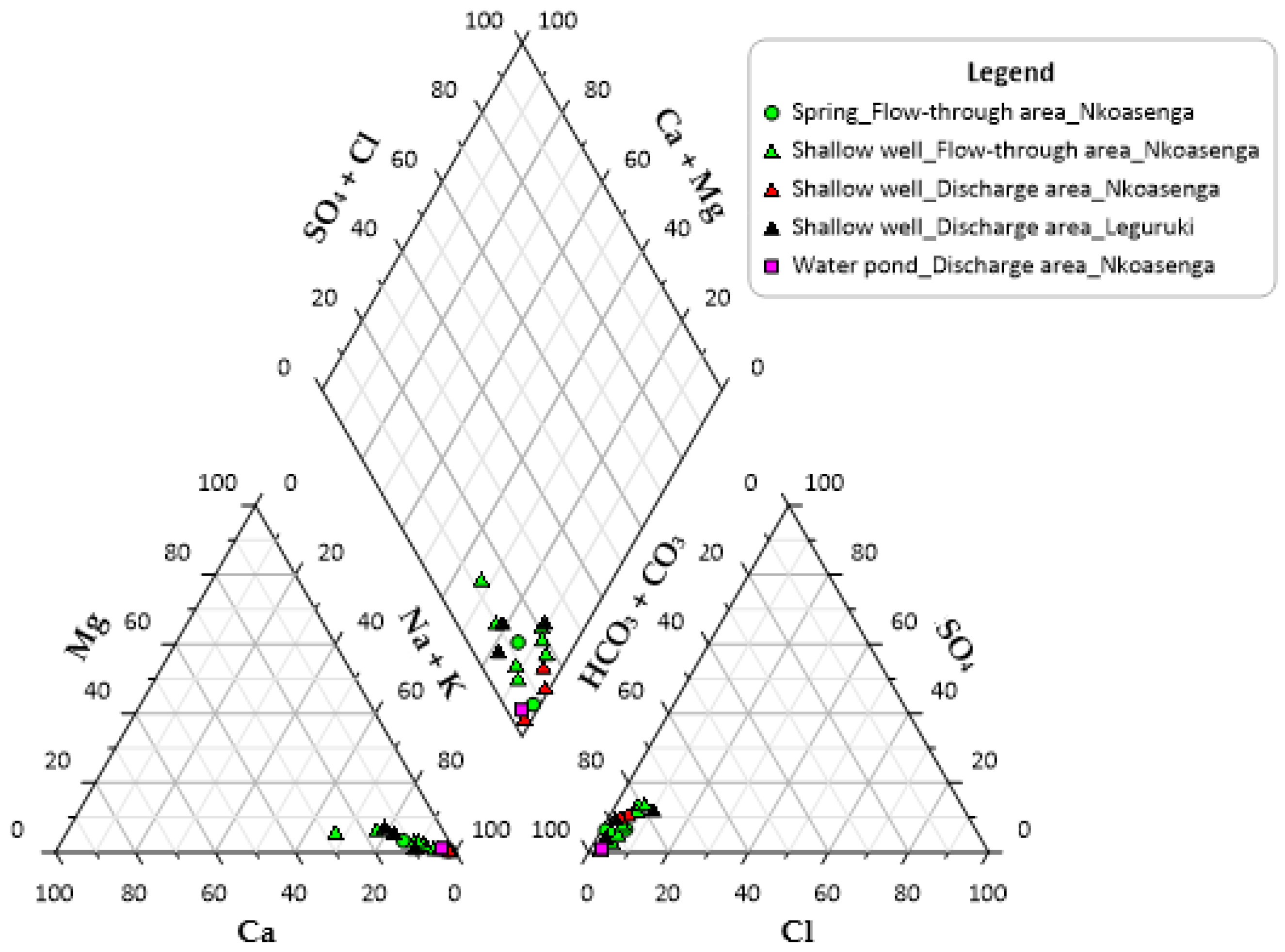
| Nkoasenga | Springs | 1 | 1560 | 106 | 26.2 | 14.0 | 2.4 | 334 | 19.8 | 13.4 | 2.6 | 10.0 | 0.002 |
| 1 | 1483 | 171 | 42.8 | 2.4 | 0.4 | 478 | 25.7 | 3.3 | 10.7 | 23.5 | 0.078 | ||
| Shallow wells | 7 | 1586 | 94 | 27.5 | 12.4 | 2.4 | 295 | 22.6 | 9.5 | 3.5 | 11.6 | 0.347 | |
| 3 | 1491 | 251 | 50.8 | 4.5 | 1.2 | 508 | 35.6 | 10.9 | 68.6 | 44.3 | 0.000 | ||
| Leguruki | Shallow wells | 3 | 1354 | 111 | 33.5 | 16.2 | 3.7 | 346 | 29.9 | 11.8 | 4.6 | 26.0 | 0.002 |
| Region | Water Source | Number of Samples | Average Elevation (m) | Average Concentrations (mg/L) | |||||||||
|---|---|---|---|---|---|---|---|---|---|---|---|---|---|
| Na+ | K+ | Ca2+ | Mg2+ | (HCO3− + CO32−) * | SO42− | Cl− | F− | NO3− | NO2− | ||||
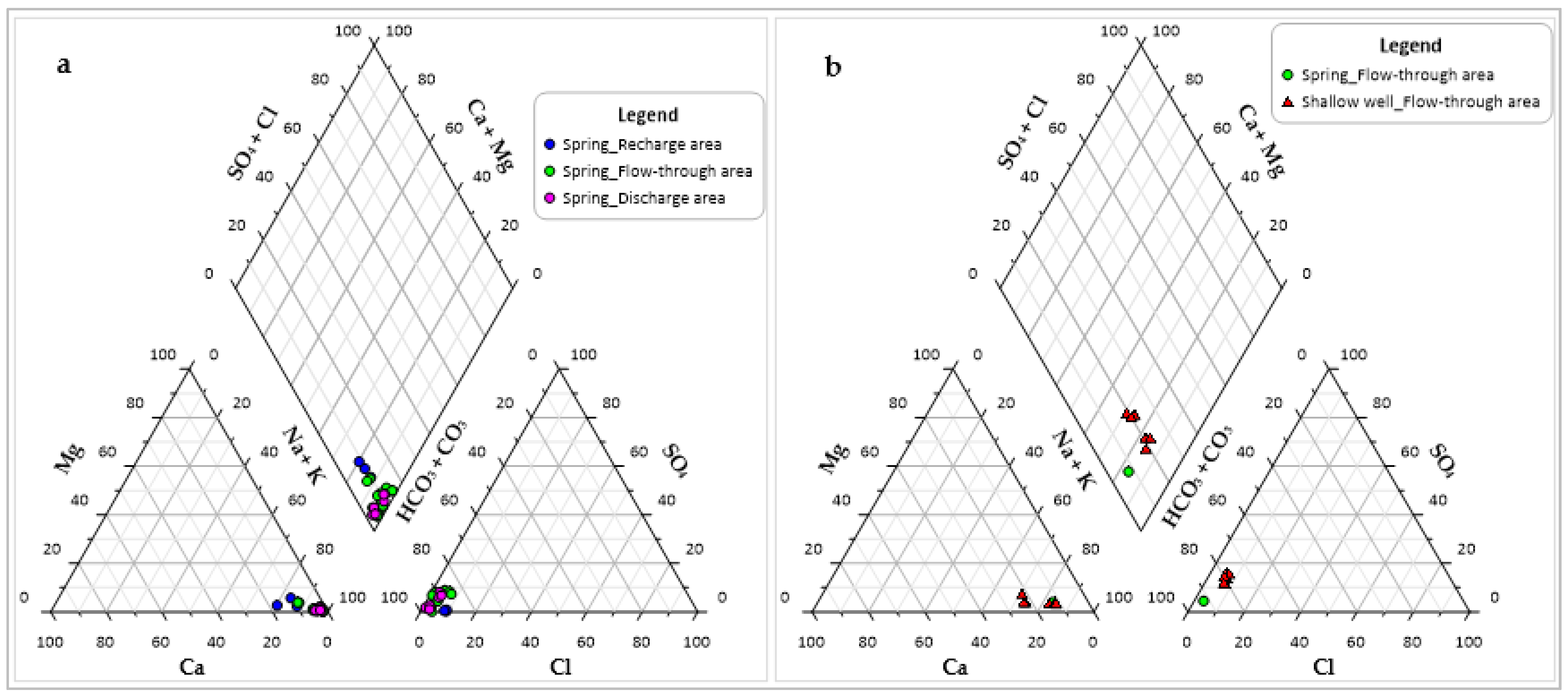
| North-western flank | Springs | 4 | 2567 | 32.2 | 11.0 | 3.3 | 0.6 | 111 | 0.3 | 4.7 | 0.8 | 0.9 | 0.001 |
| 15 | 2084 | 91.5 | 19.6 | 2.9 | 0.6 | 185 | 8.8 | 4.1 | 24.4 | 8.4 | 0.328 | ||
| 6 | 1838 | 99.1 | 24.6 | 3.2 | 0.5 | 235 | 8.7 | 4.1 | 24.8 | 5.2 | 0.022 | ||
| Western flank | Spring | 1 | 2240 | 111 | 23.4 | 16.4 | 3.1 | 365 | 14.0 | 7.7 | 3.4 | 6.0 | 0.004 |
| Shallow wells | 6 | 1649 | 180 | 39.9 | 39.7 | 6.1 | 539 | 75.1 | 25.7 | 3.7 | 36.7 | 2.743 | |
| Water Source | Number of Samples | Average Elevation (m) | Average Well Depth (m) | Average Concentrations (mg/L) | |||||||||
|---|---|---|---|---|---|---|---|---|---|---|---|---|---|
| Na+ | K+ | Ca2+ | Mg2+ | (HCO3− + CO32−) * | SO42− | Cl− | F− | NO3− | NO2− | ||||
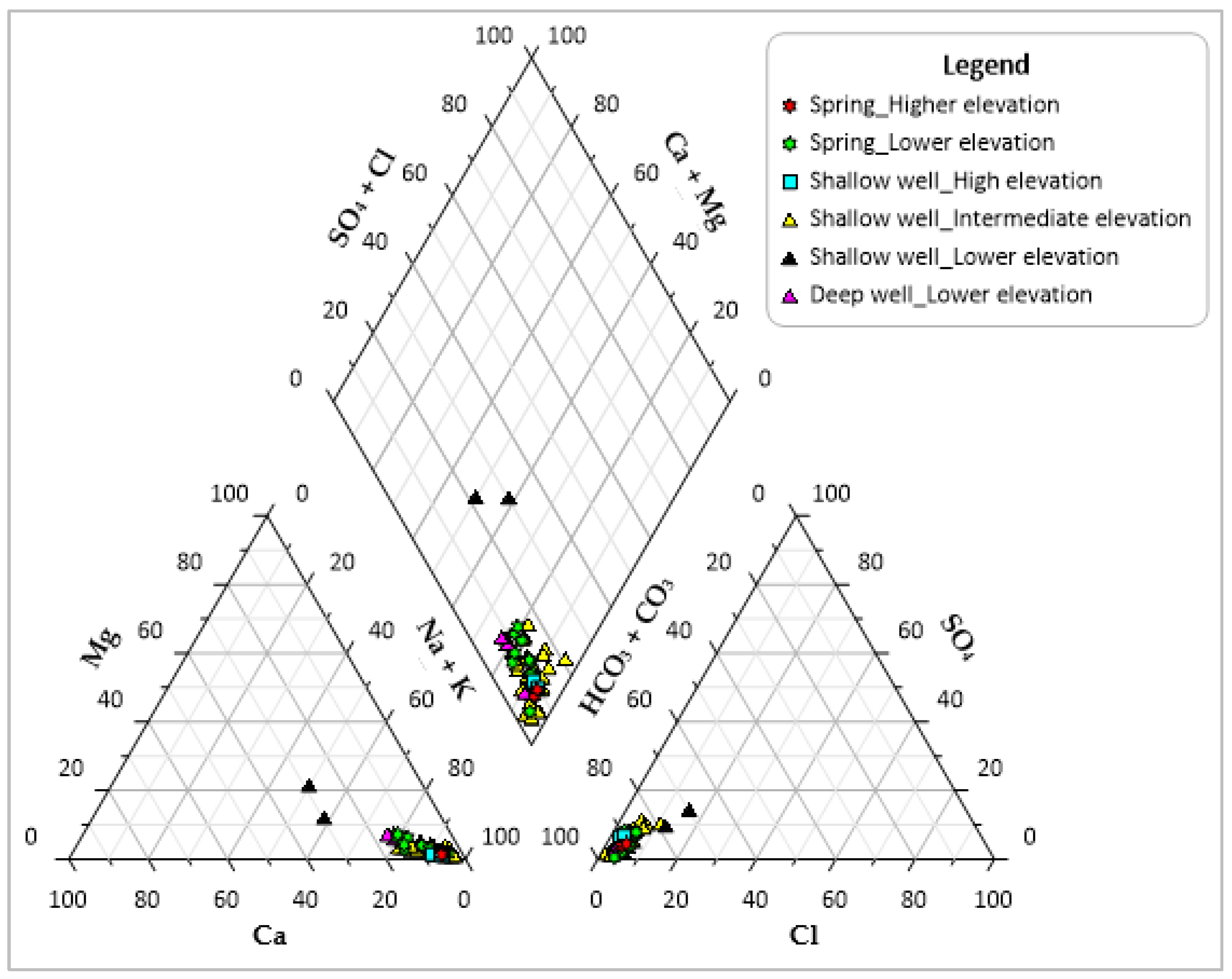
| Springs | 2 | 1921 | 76.4 | 22.8 | 4.4 | 0.7 | 212 | 7.5 | 6.1 | 12.0 | 3.0 | 0.02 | |
| 10 | 1566 | 182 | 60.0 | 21.7 | 4.9 | 539 | 23.4 | 16.6 | 8.1 | 37.0 | 0.16 | ||
| Shallow wells | 3 | 1631 | 16 | 160 | 30.8 | 10.2 | 1.4 | 439 | 24.5 | 9.0 | 6.3 | 20.8 | 0.15 |
| 51 | 1548 | 19 | 248 | 55.9 | 18.5 | 4.0 | 672 | 34.0 | 18.3 | 15.8 | 37.3 | 0.64 | |
| 2 | 1379 | 6 | 109 | 36.9 | 61.1 | 20.8 | 367 | 47.3 | 40.9 | 2.3 | 151 | 0.67 | |
| Deep wells | 3 | 1467 | 151 | 120 | 27.7 | 19.3 | 4.8 | 400 | 16.2 | 7.5 | 5.4 | 5.4 | 0.02 |
| Town | Water Point ID | Water Source | Elevation (m) | Well Depth (m) | SO42− (mg/L) | Cl− (mg/L) | NO3− (mg/L) |
|---|---|---|---|---|---|---|---|
| Ngaramtoni | W36 | Shallow well | 1561 | 19 | 59.2 | 28.7 | 129 |
| W69 | Shallow well | 1513 | 19 | 88.7 | 67.0 | 258 | |
| Arusha | W100 | Shallow well | 1385 | 9 | 37.0 | 34.6 | 134 |
| W101 | Shallow well | 1373 | 2 | 57.6 | 47.2 | 167 |
| Region | Water Source | Number of Water Points | Range of F− Values (mg/L) | Within WHO or Tanzanian Standard | Drinking Purpose |
|---|---|---|---|---|---|
| Eastern flank, inside the Arusha National Park | Springs | 10 | 0.1–1.5 | WHO standard | Yes |
| 3 | 1.7–3.9 | Tanzanian standard | Yes | ||
| 2 | 15–19 | Above the standards | Yes | ||
| Far east of the eastern flank (Northern flank of Ngurdoto crater) | Springs | 1 | 2.6 | Tanzanian standard | No, used for other domestic use and livestock |
| 1 | 11 | Above the standards | Yes | ||
| Wells | 2 | 1.0–1.3 | WHO standard | Yes | |
| 4 | 1.6–3.5 | Tanzanian standard | Yes | ||
| 4 | 4.5–8.2 | Above the standards | Yes | ||
| 3 | 31–134 | Above the standards | Yes | ||
| North-eastern flank | Springs | 2 | 4.2–4.3 | Above the standards | Yes |
| 1 | 4.3 | Above the standards | No, used for irrigation and livestock | ||
| 4 | 6–13 | Above the standards | Yes | ||
| 5 | 48–75 | Above the standards | No, used for irrigation and livestock | ||
| Wells | 1 | 3.6 | Tanzanian standard | No, used for irrigation | |
| 1 | 12 | Above the standards | No, used for other domestic use and livestock | ||
| 2 | 14–19 | Above the standards | Yes | ||
| 2 | 20–22 | Above the standards | No, used for other domestic use and livestock | ||
| 1 | 121 | Above the standards | Yes | ||
| North-western flank | Springs | 3 | 0.4–0.8 | WHO standard | Yes |
| 1 | 1.7 | Tanzanian standard | Yes | ||
| 5 | 18–27 | Above the standards | Yes | ||
| 1 | 28 | Above the standards | No, used for irrigation | ||
| 1 | 48 | Above the standards | Yes | ||
| Western flank | Spring | 1 | 3.4 | Tanzanian standard | Yes |
| Wells | 3 | 3.5–4.0 | Tanzanian standard | Yes | |
| South-western flank | Springs | 8 | 5.1–13.0 | Above the standards | Yes |
| Wells | 5 | 2.0–3.8 | Tanzanian standard | Yes | |
| 5 | 4.6–6.1 | Above the standards | Yes | ||
| 1 | 6.3 | Above the standards | No, used for irrigation | ||
| 8 | 6.3–8.5 | Above the standards | Yes | ||
| 1 | 9.3 | Above the standards | No, used for other domestic use and irrigation | ||
| 15 | 9.6–17.0 | Above the standards | Yes | ||
| 6 | 22.4–60.4 | Above the standards | Yes | ||
| 1 | 77.9 | Above the standards | No, used for other domestic use and irrigation |
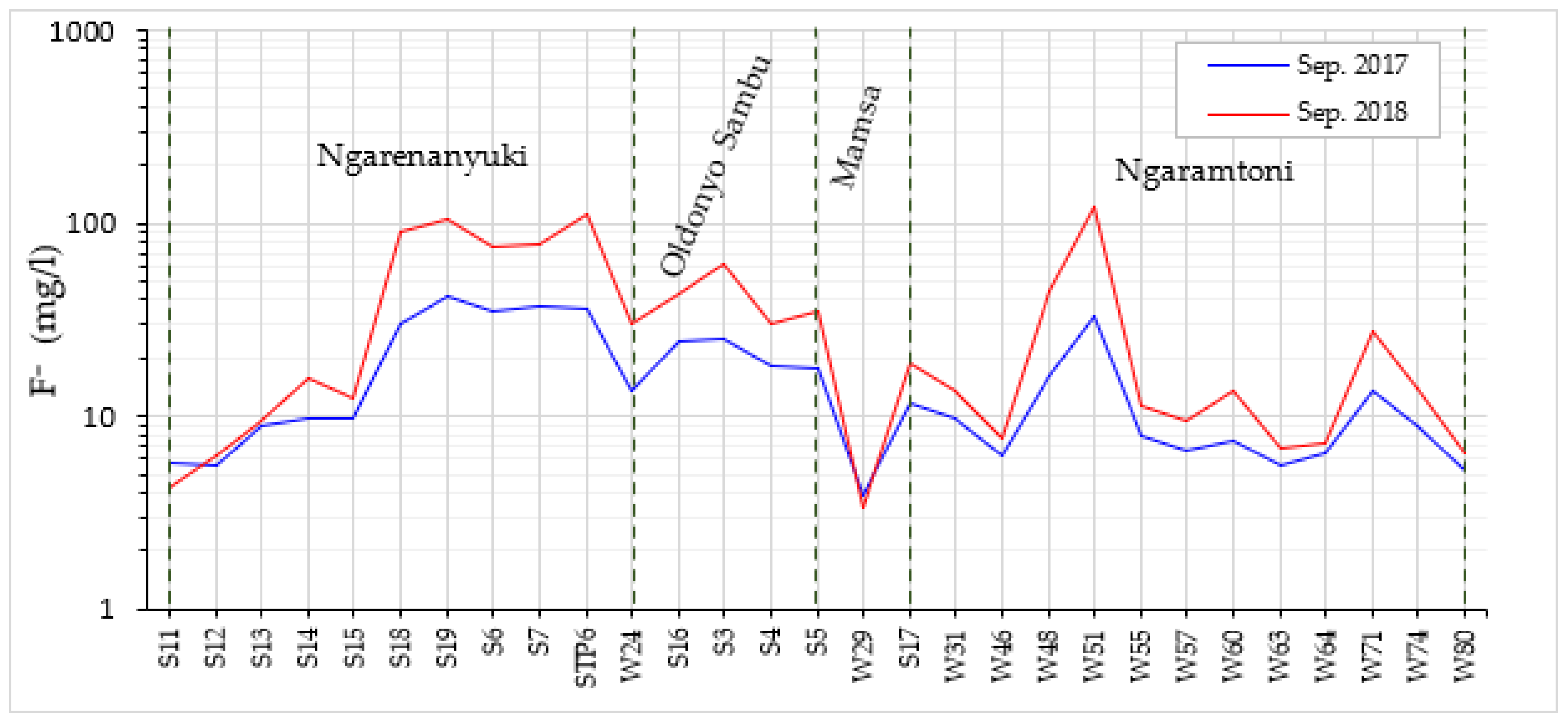
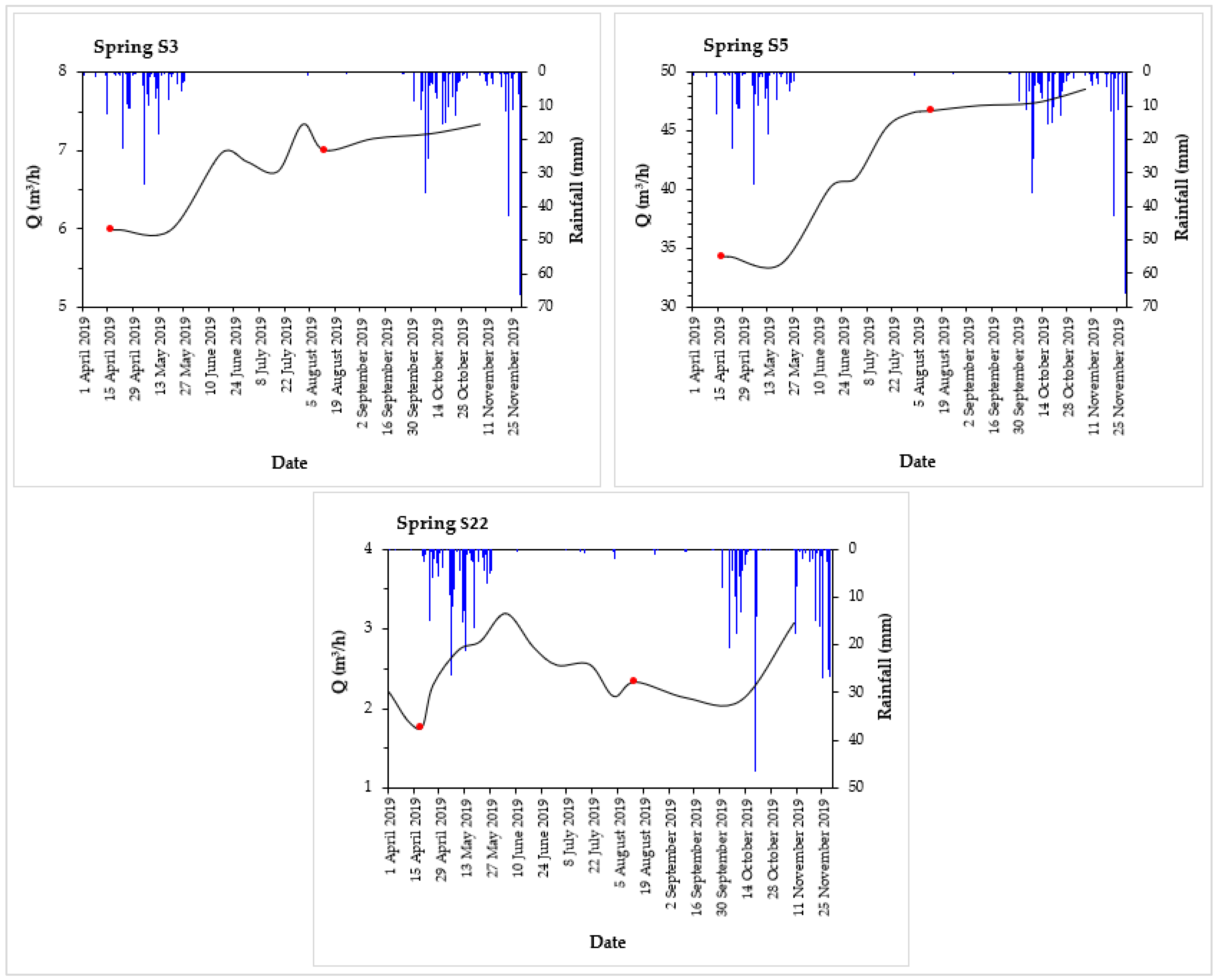
| Spring ID | Date | Q (m3/hr) | F− (mg/L) | EC (μS/cm at 25 °C) |
|---|---|---|---|---|
| S3 | April 2019 | 5.98 | 20.3 | 443 |
| Aug. 2019 | 7.17 | 18.6 | 415 | |
| S5 | April 2019 | 34.23 | 15.0 | 436 |
| Aug. 2019 | 46.62 | 13.7 | 407 | |
| S22 | April 2019 | 1.97 | 5.5 | 822 |
| Aug. 2019 | 2.24 | 4.7 | 781 |
Publisher’s Note: MDPI stays neutral with regard to jurisdictional claims in published maps and institutional affiliations. |
© 2021 by the authors. Licensee MDPI, Basel, Switzerland. This article is an open access article distributed under the terms and conditions of the Creative Commons Attribution (CC BY) license (https://creativecommons.org/licenses/by/4.0/).
Share and Cite
Bennett, G.; Van Reybrouck, J.; Shemsanga, C.; Kisaka, M.; Tomašek, I.; Fontijn, K.; Kervyn, M.; Walraevens, K. Hydrochemical Characterisation of High-Fluoride Groundwater and Development of a Conceptual Groundwater Flow Model Using a Combined Hydrogeological and Hydrochemical Approach on an Active Volcano: Mount Meru, Northern Tanzania. Water 2021, 13, 2159. https://doi.org/10.3390/w13162159
Bennett G, Van Reybrouck J, Shemsanga C, Kisaka M, Tomašek I, Fontijn K, Kervyn M, Walraevens K. Hydrochemical Characterisation of High-Fluoride Groundwater and Development of a Conceptual Groundwater Flow Model Using a Combined Hydrogeological and Hydrochemical Approach on an Active Volcano: Mount Meru, Northern Tanzania. Water. 2021; 13(16):2159. https://doi.org/10.3390/w13162159
Chicago/Turabian StyleBennett, George, Jill Van Reybrouck, Ceven Shemsanga, Mary Kisaka, Ines Tomašek, Karen Fontijn, Matthieu Kervyn, and Kristine Walraevens. 2021. "Hydrochemical Characterisation of High-Fluoride Groundwater and Development of a Conceptual Groundwater Flow Model Using a Combined Hydrogeological and Hydrochemical Approach on an Active Volcano: Mount Meru, Northern Tanzania" Water 13, no. 16: 2159. https://doi.org/10.3390/w13162159
APA StyleBennett, G., Van Reybrouck, J., Shemsanga, C., Kisaka, M., Tomašek, I., Fontijn, K., Kervyn, M., & Walraevens, K. (2021). Hydrochemical Characterisation of High-Fluoride Groundwater and Development of a Conceptual Groundwater Flow Model Using a Combined Hydrogeological and Hydrochemical Approach on an Active Volcano: Mount Meru, Northern Tanzania. Water, 13(16), 2159. https://doi.org/10.3390/w13162159


