An Integrated Modeling System for the Evaluation of Water Resources in Coastal Agricultural Watersheds: Application in Almyros Basin, Thessaly, Greece

 ,
, 
 ,
,  and
and
Abstract
1. Introduction
2. Models and Methods
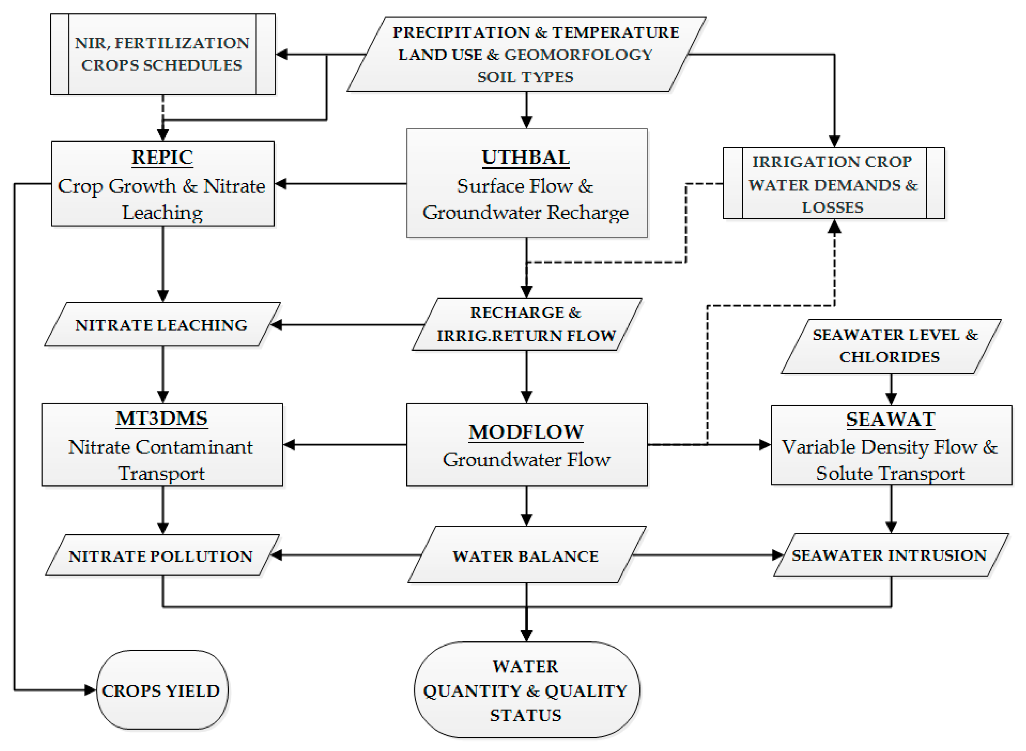
2.1. Modeling System
2.1.1. Surface Hydrology Simulation Model Description
- Multiplication of the precipitation time-series of each station with the respective Thiessen polygon ratio of a sub-basin. The Thiessen areal precipitation, Pth, is considered at the mean elevation of the sub-basin.
- The correction of the estimation of the mean areal precipitation is performed with the monthly precipitation gradient of the whole basin. The reduction to the mean elevation of the sub-basin, Yb, from the elevation of each station, Yst, is equal to their difference, dh:
- The corrected areal precipitation, Pb, attributed to the mean elevation of each sub-basin is given by the equation:
2.1.2. Groundwater Flow Model Description
2.1.3. Nitrate Leaching Simulation Model Description
2.1.4. Nitrate Transport and Dispersion Model Description
2.1.5. Chloride Solute Transport and Dispersion Model Description
2.2. Statistical and Graphical Evaluation of the Models
3. Study Area and Database
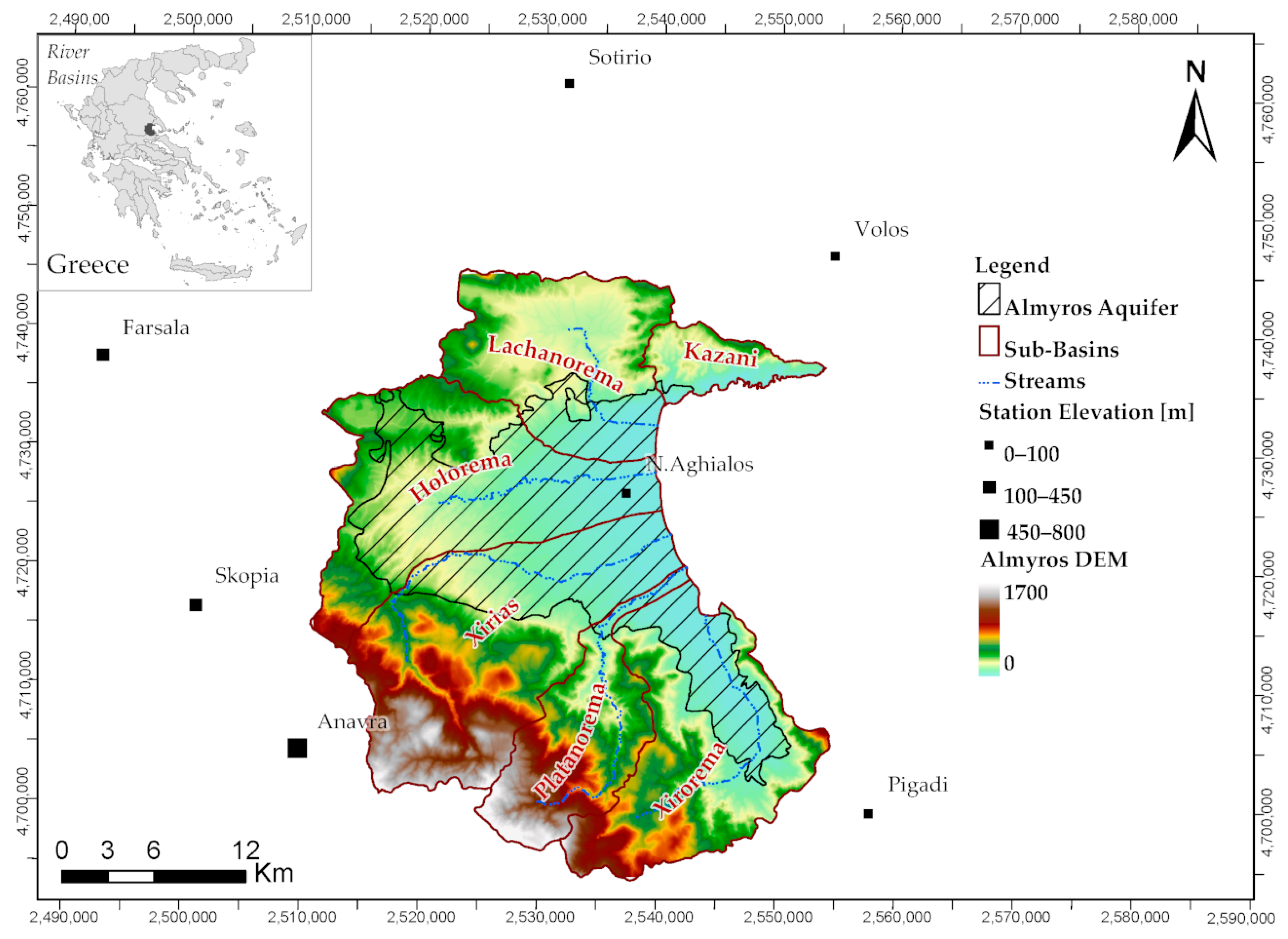
3.1. Study Area
3.2. Database
3.2.1. Meteorological Data
3.2.2. Land Use
3.2.3. Soil Characteristics of Unsaturated Zone
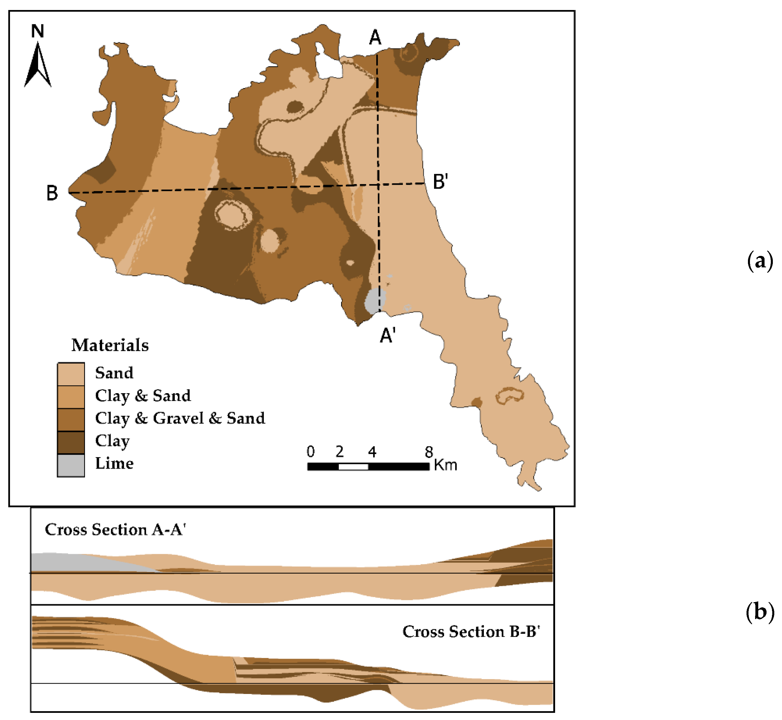
3.2.4. Geology and Hydrogeological Setting and Data
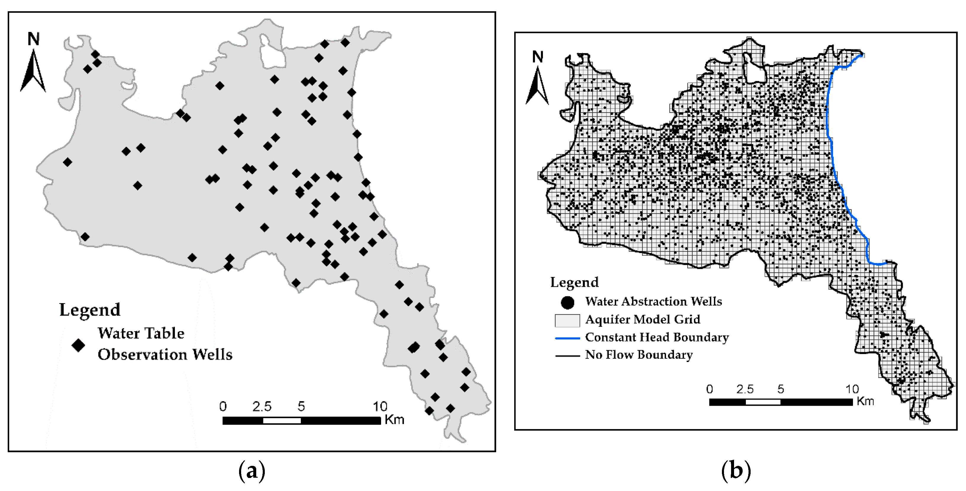
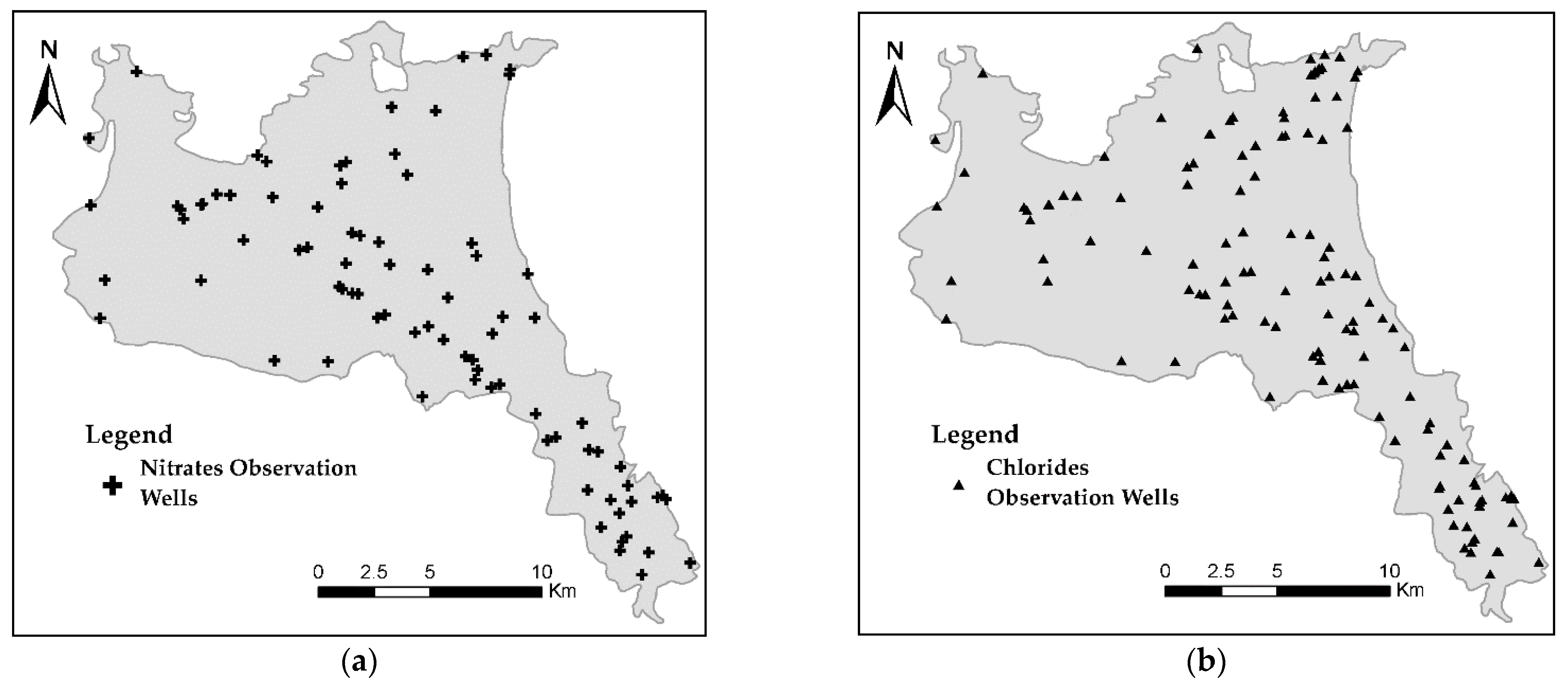
3.2.5. Observation Data of Water Table, Nitrate Concentrations, and Chloride Concentrations
4. Results
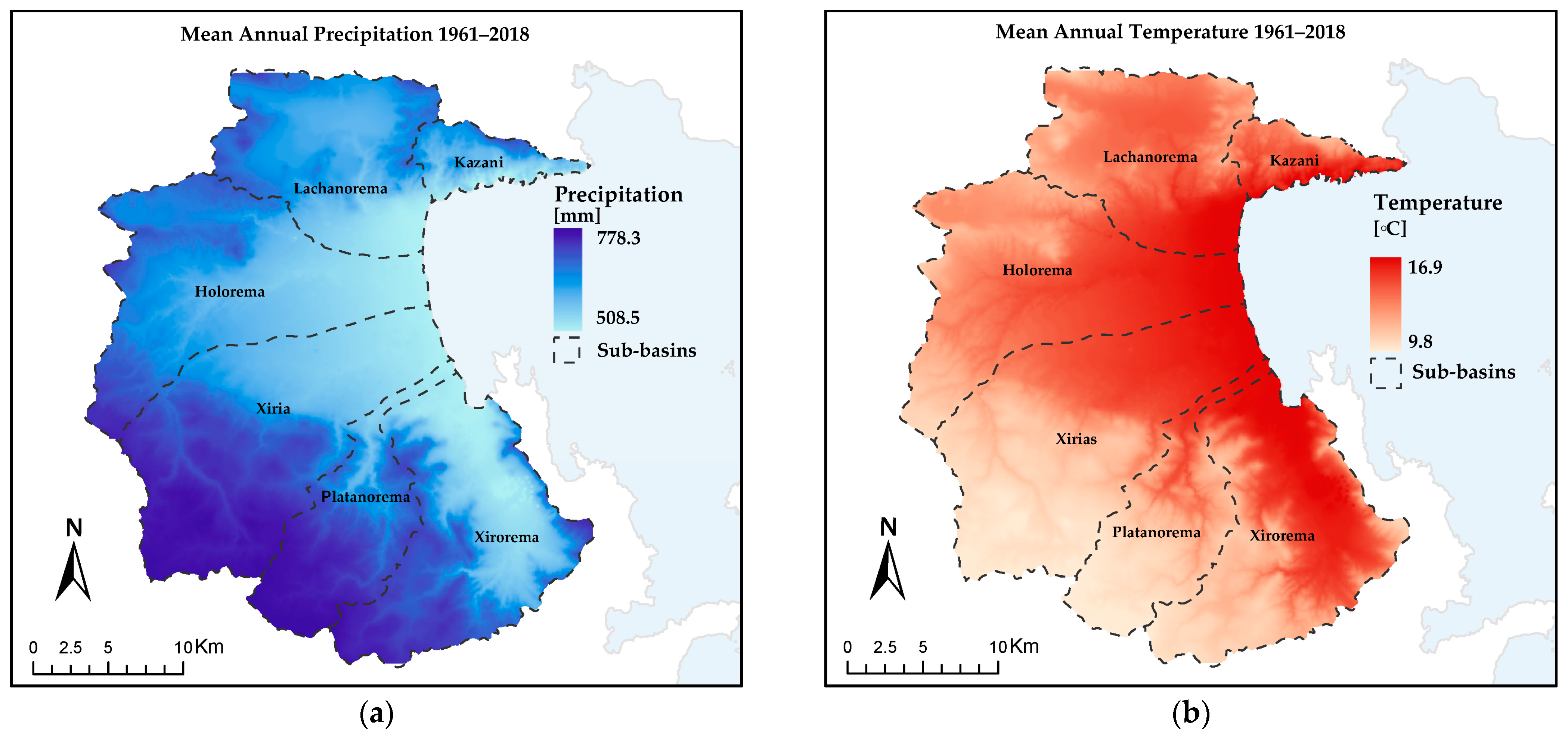
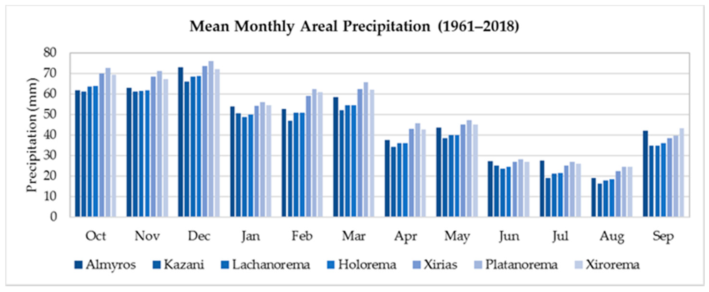
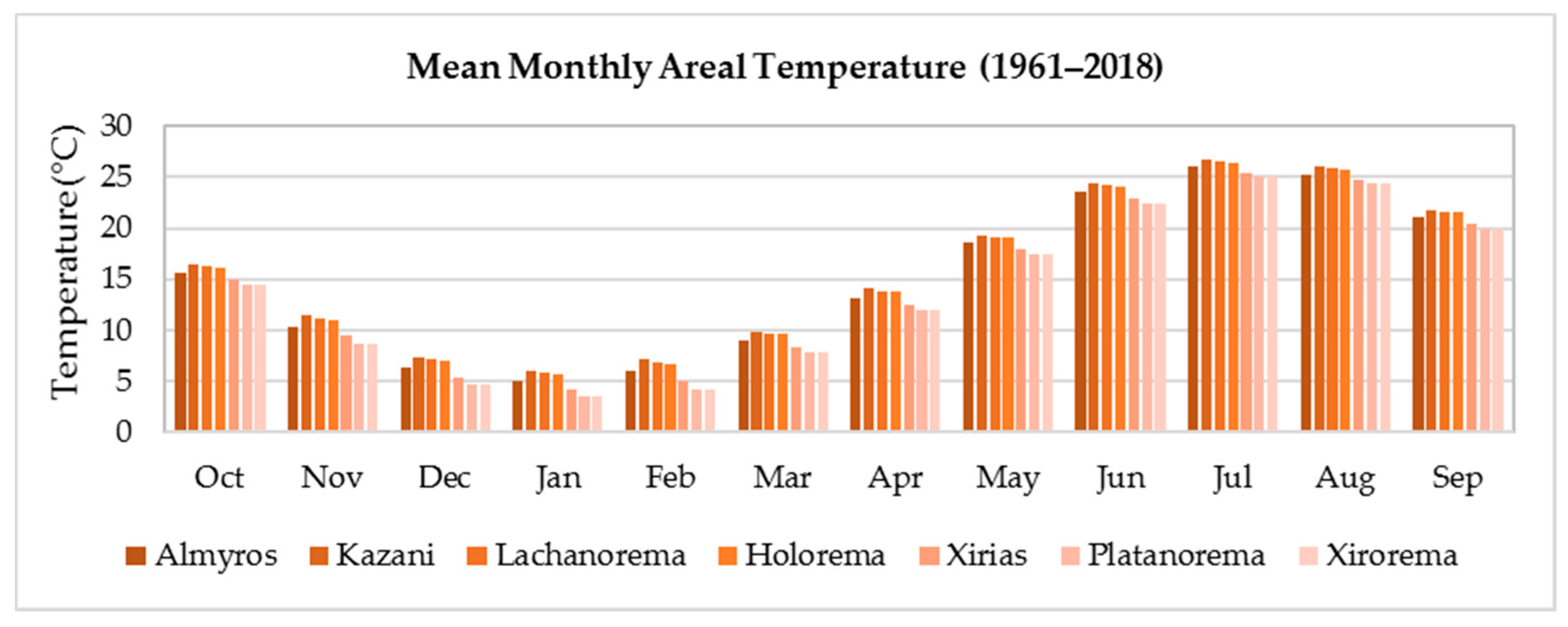
4.1. Mean Areal Precipitation and Temperature
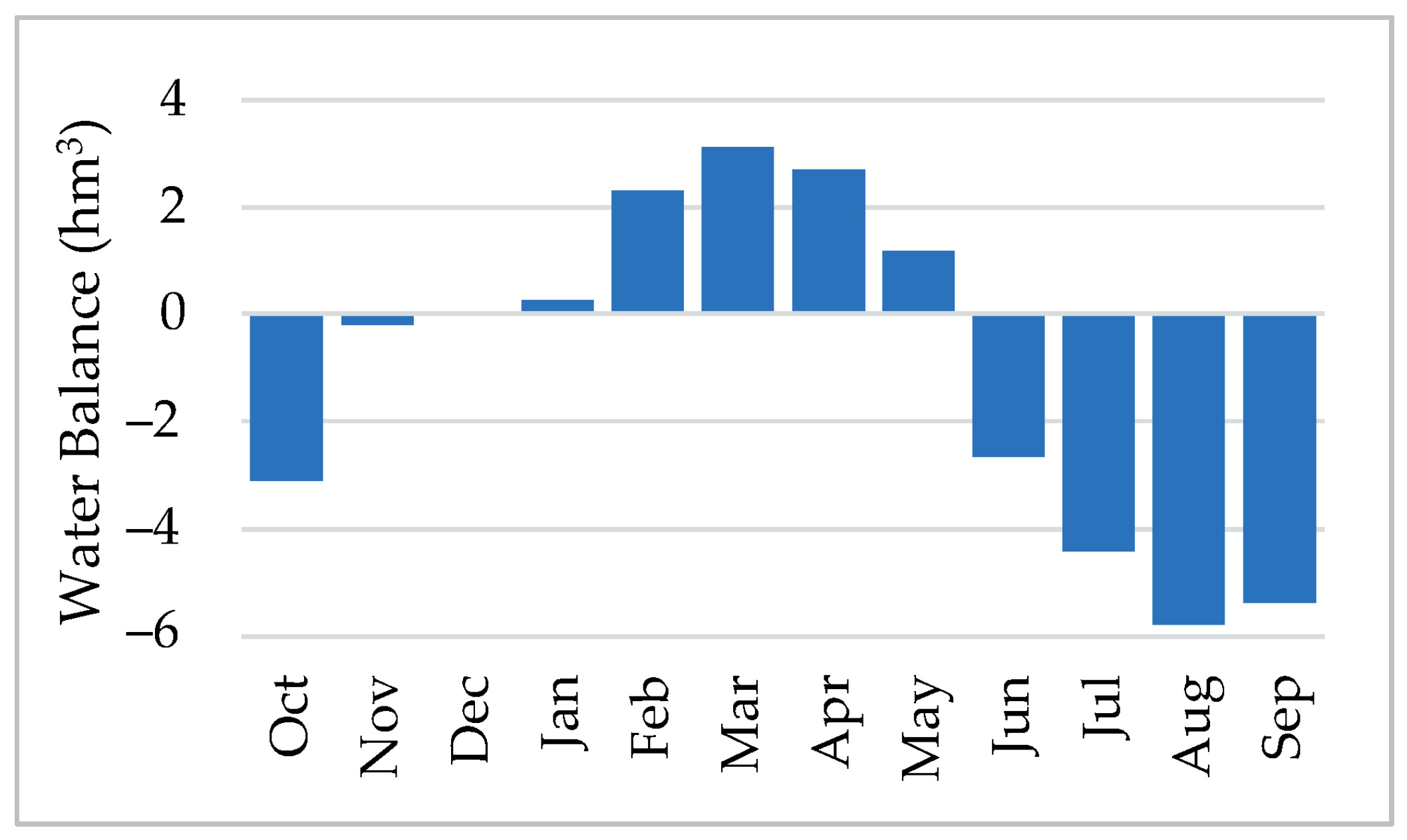
4.2. Surface Hydrology-Groundwater Recharge
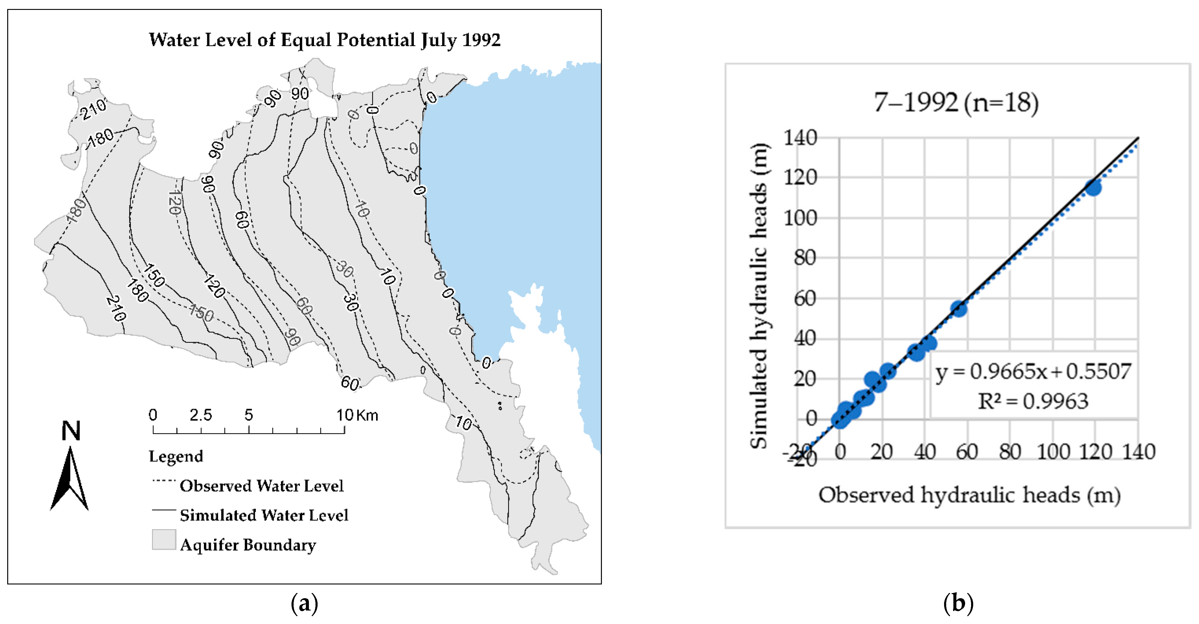
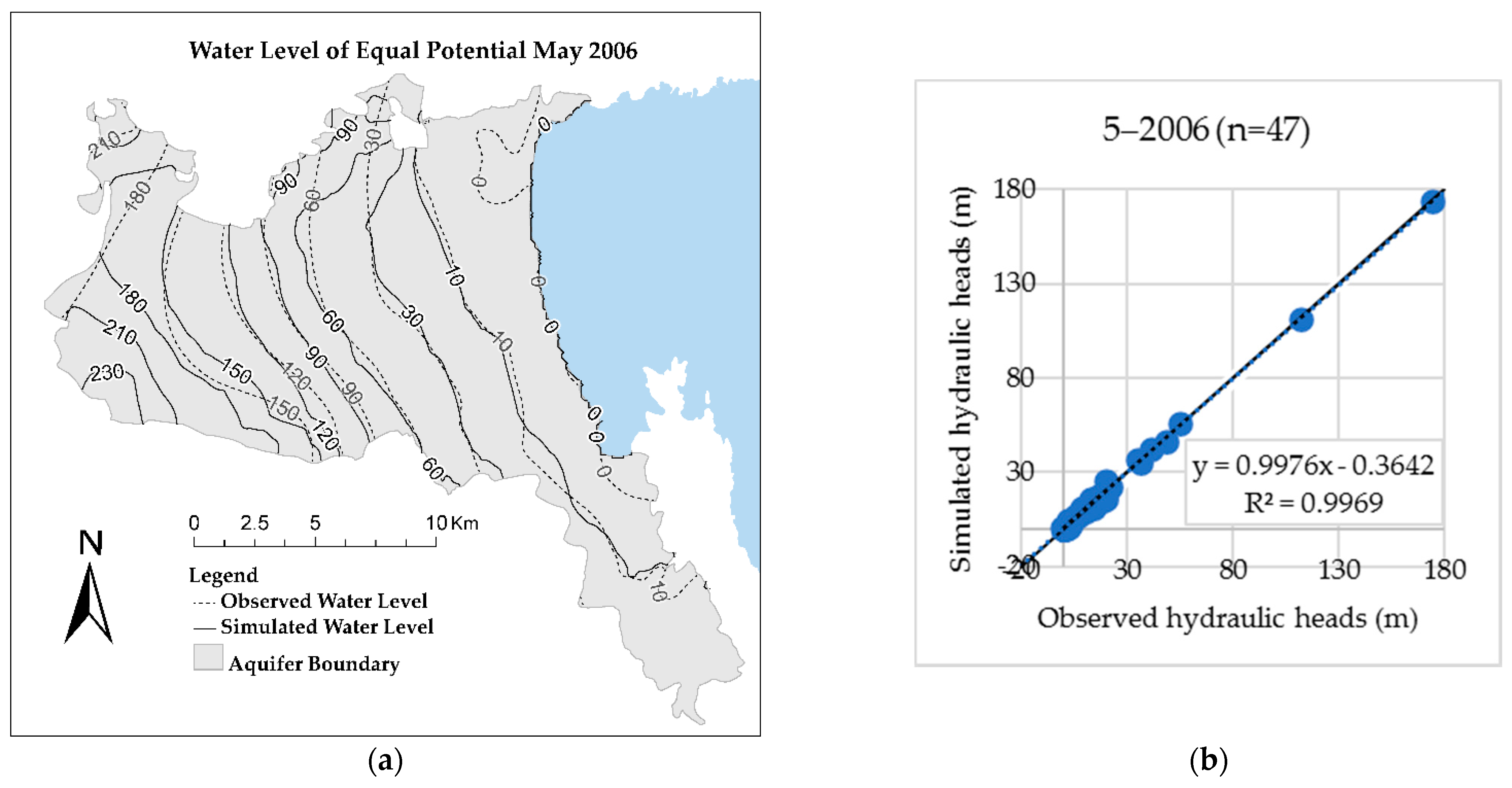
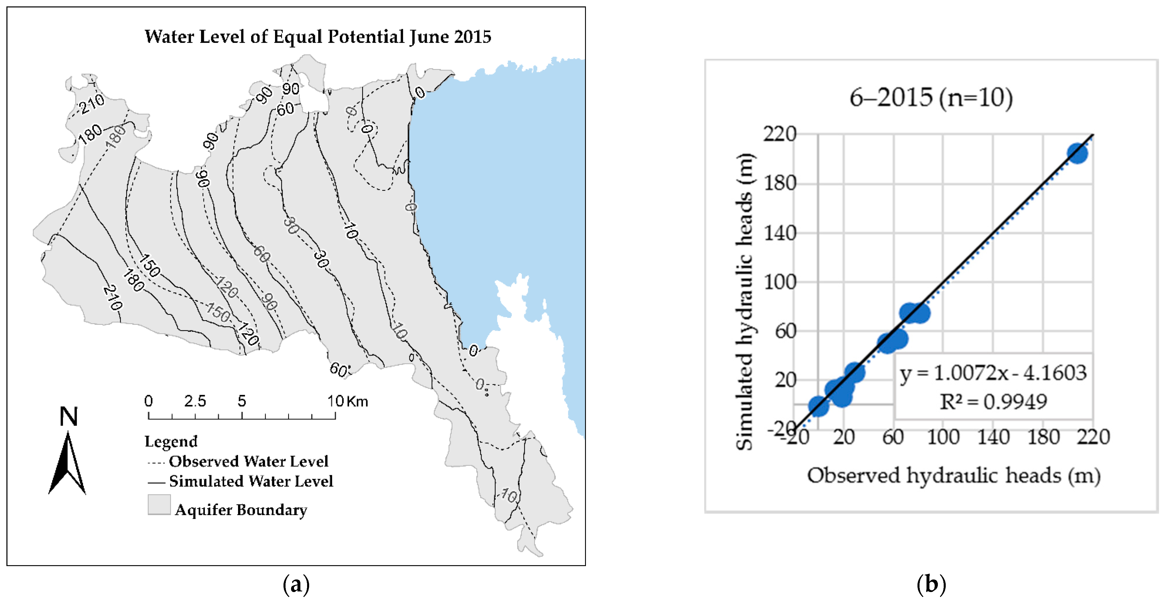
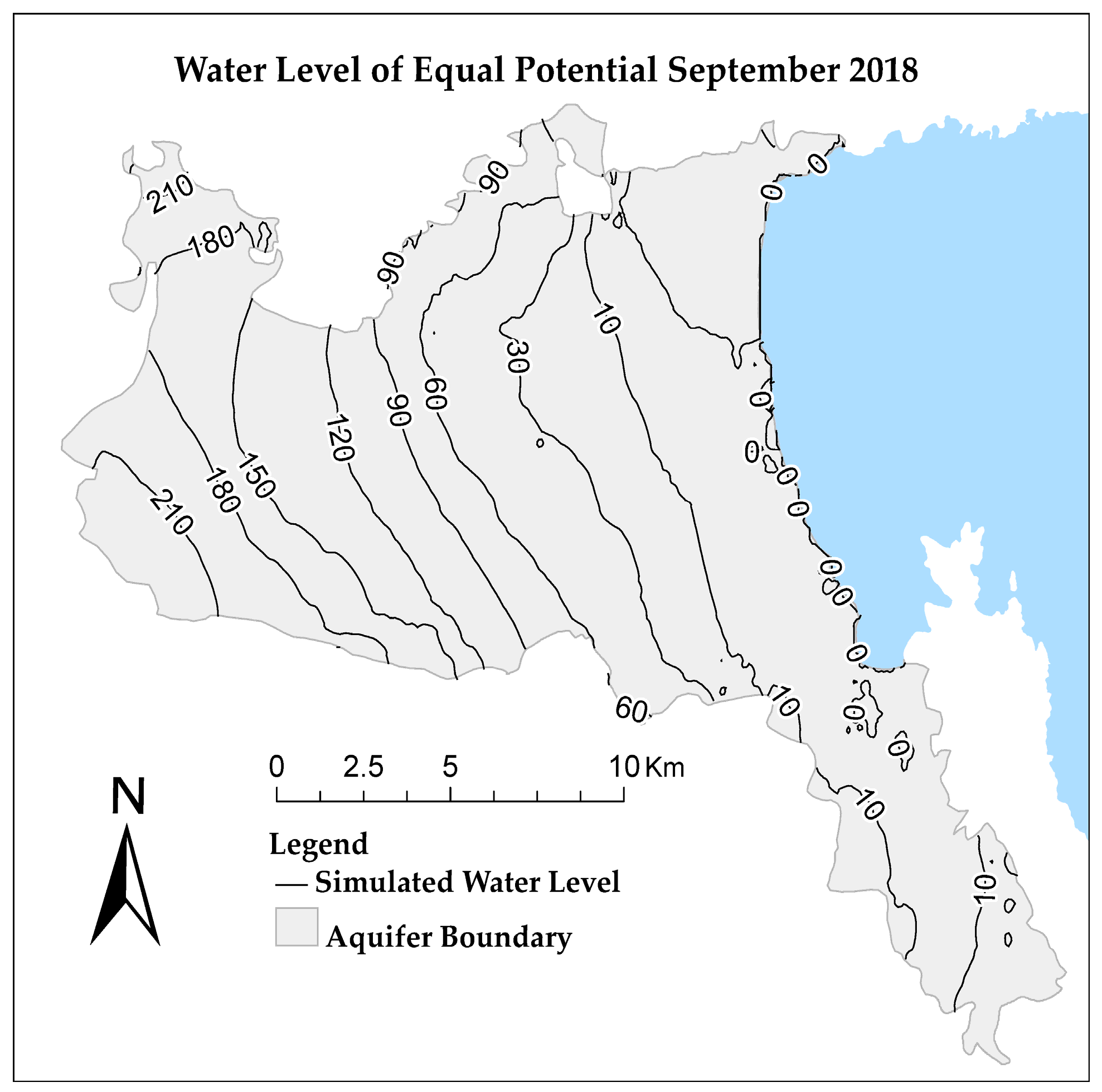
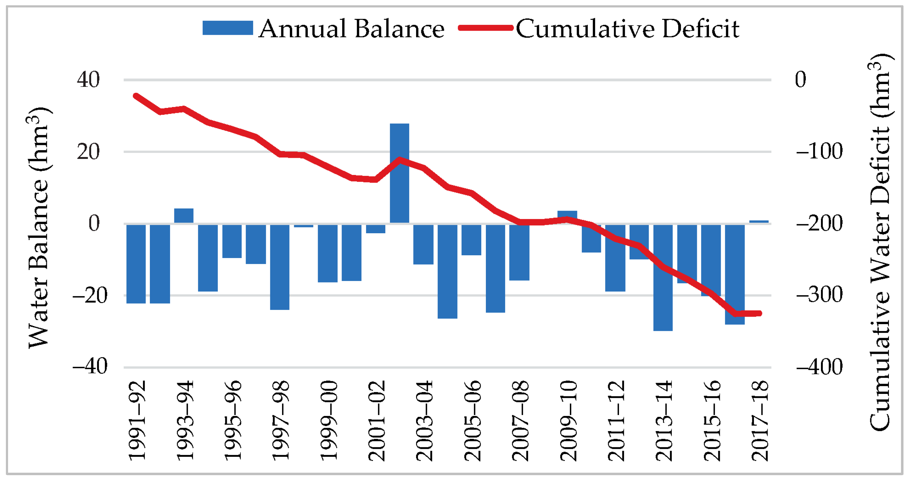
4.3. Ground Water Flow
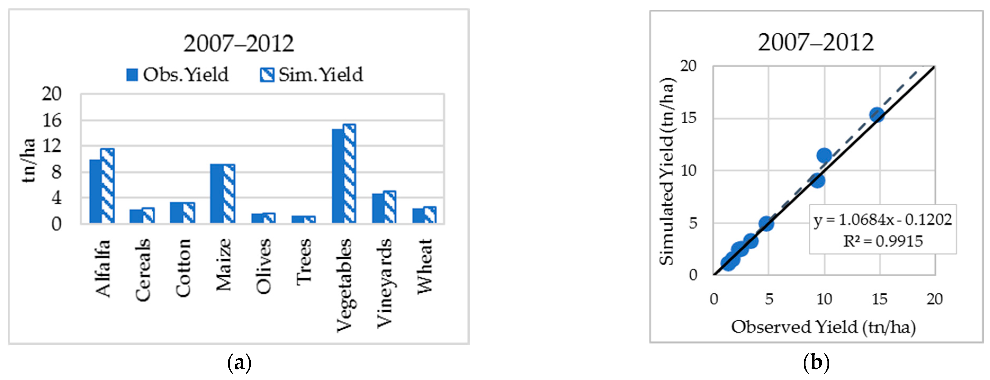
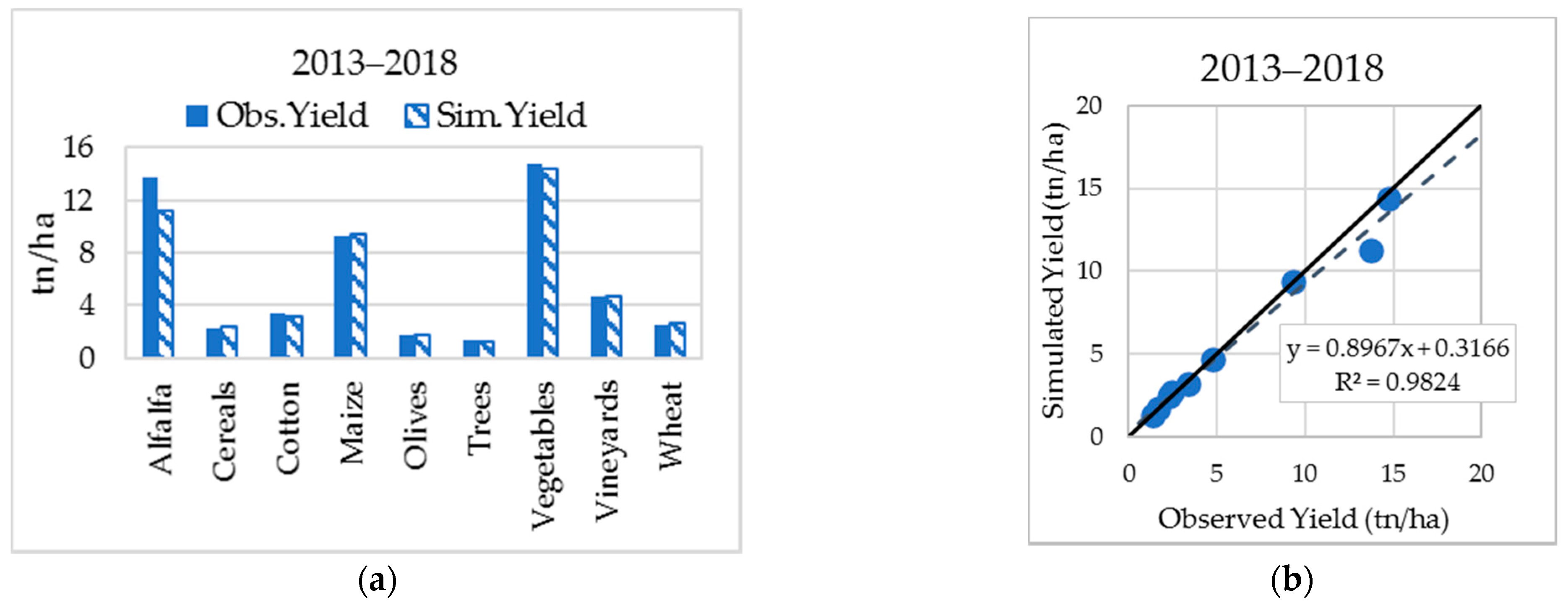
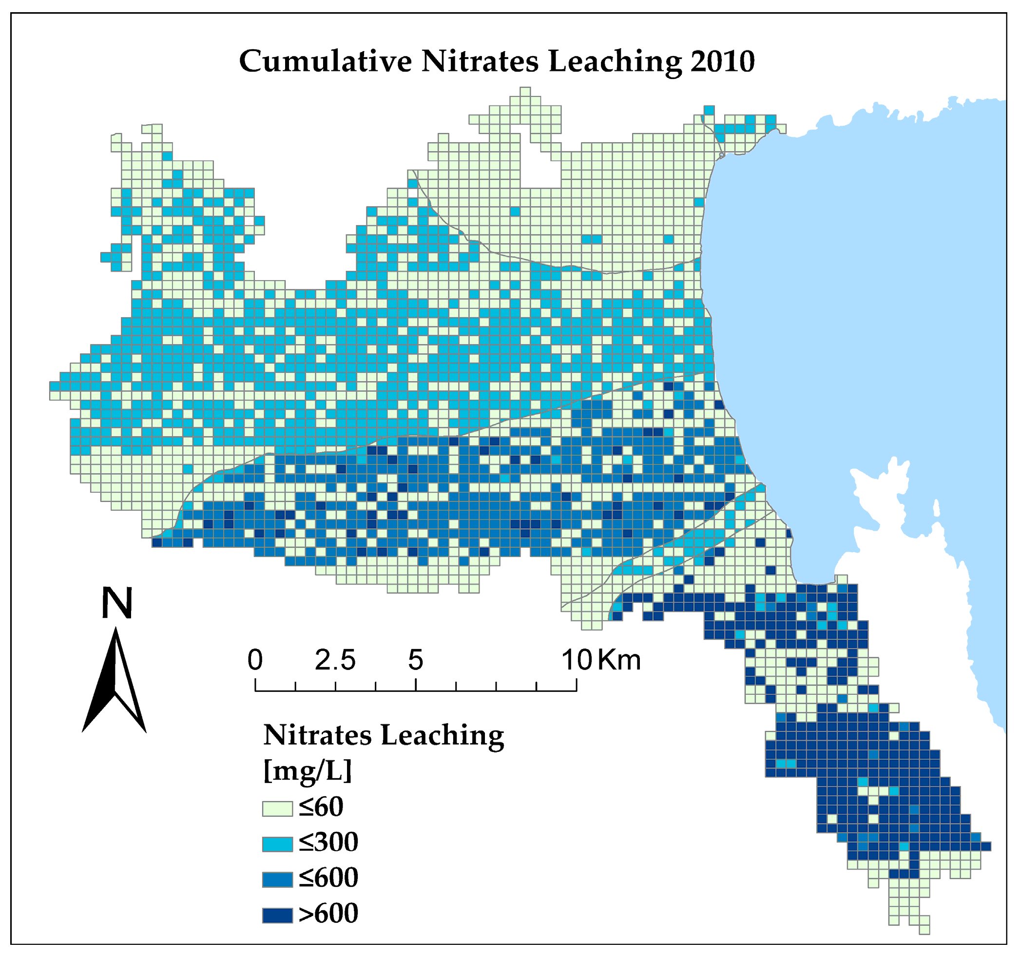
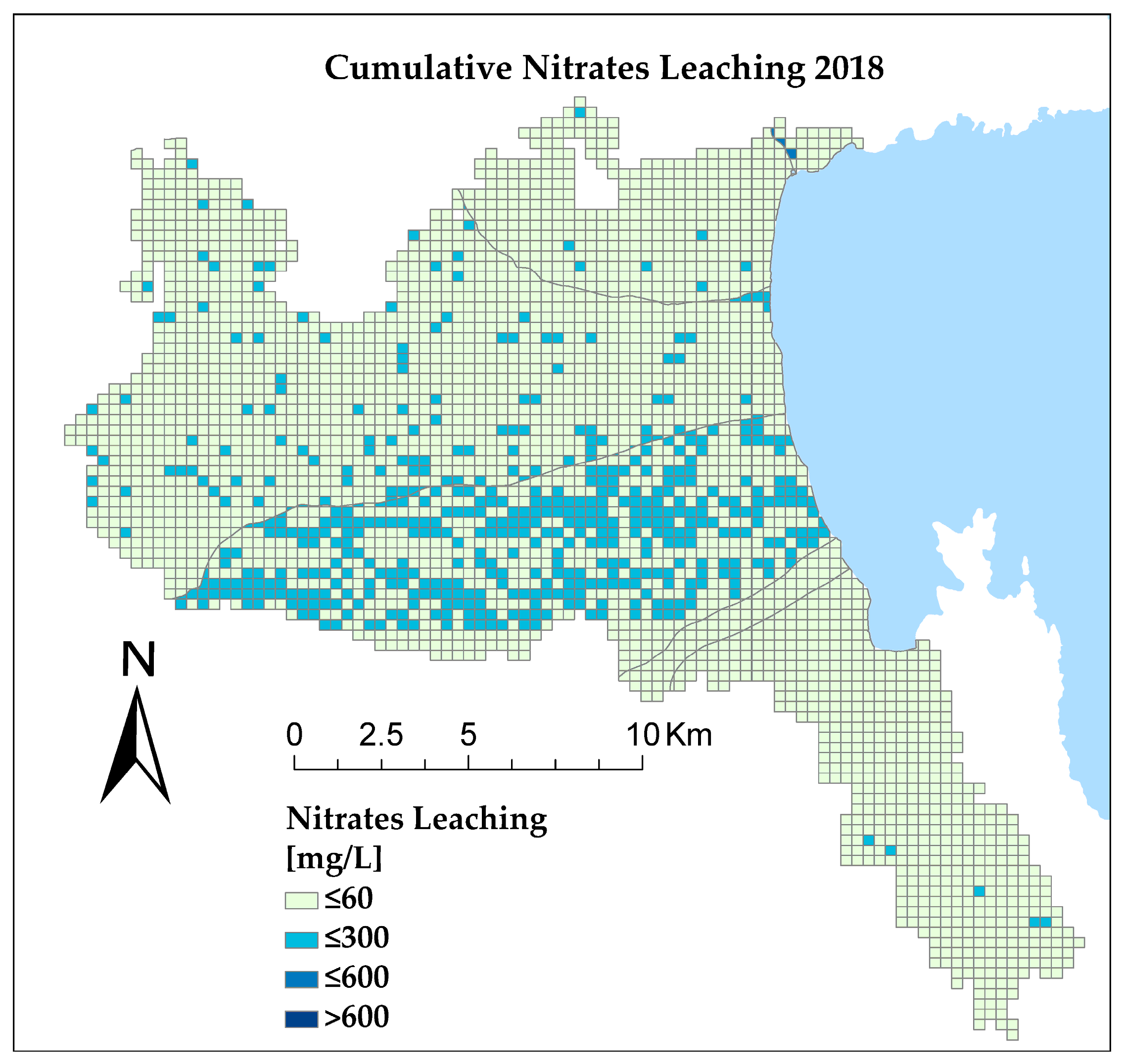
4.4. Nitrate Leaching Simulation
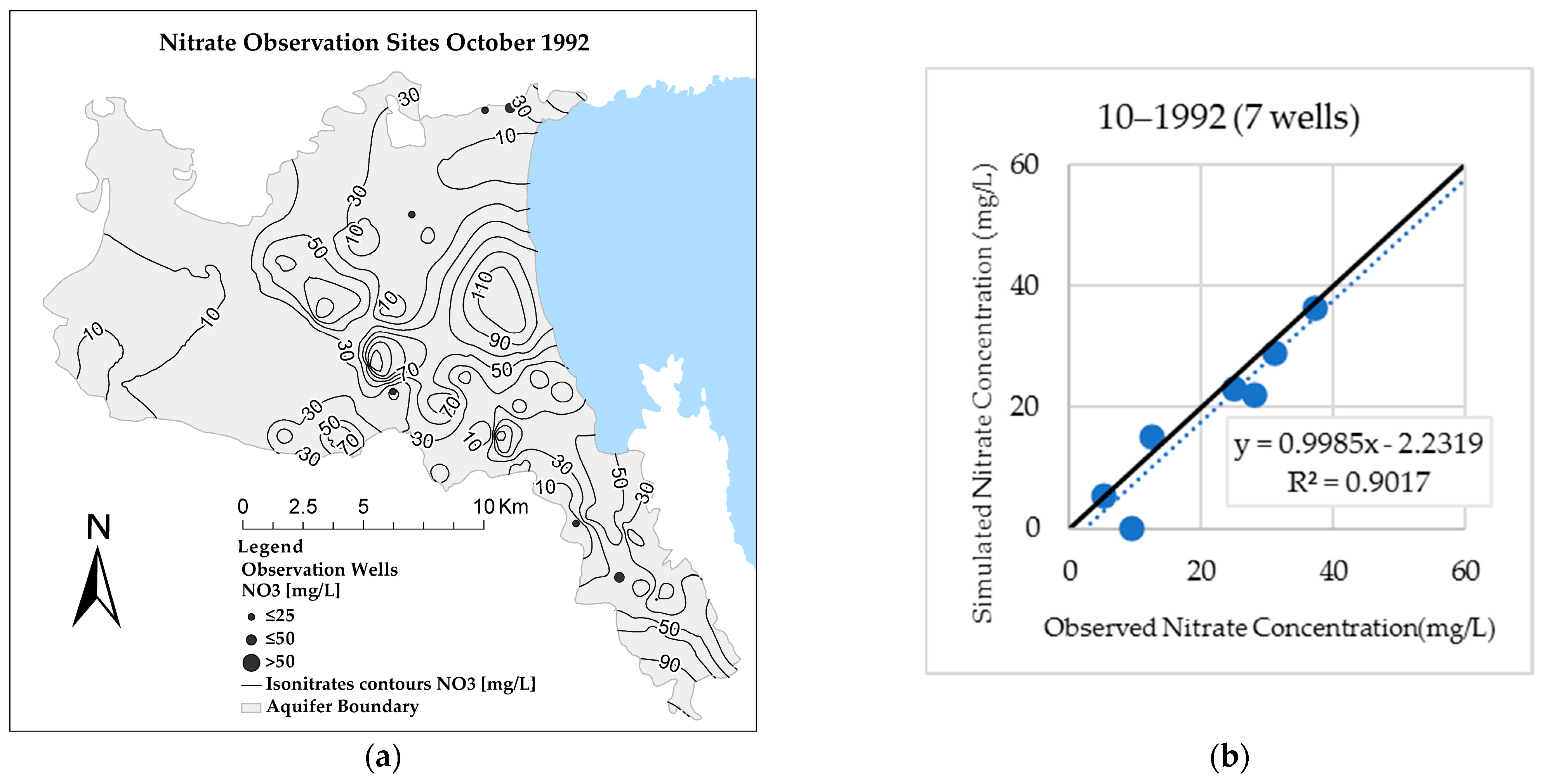
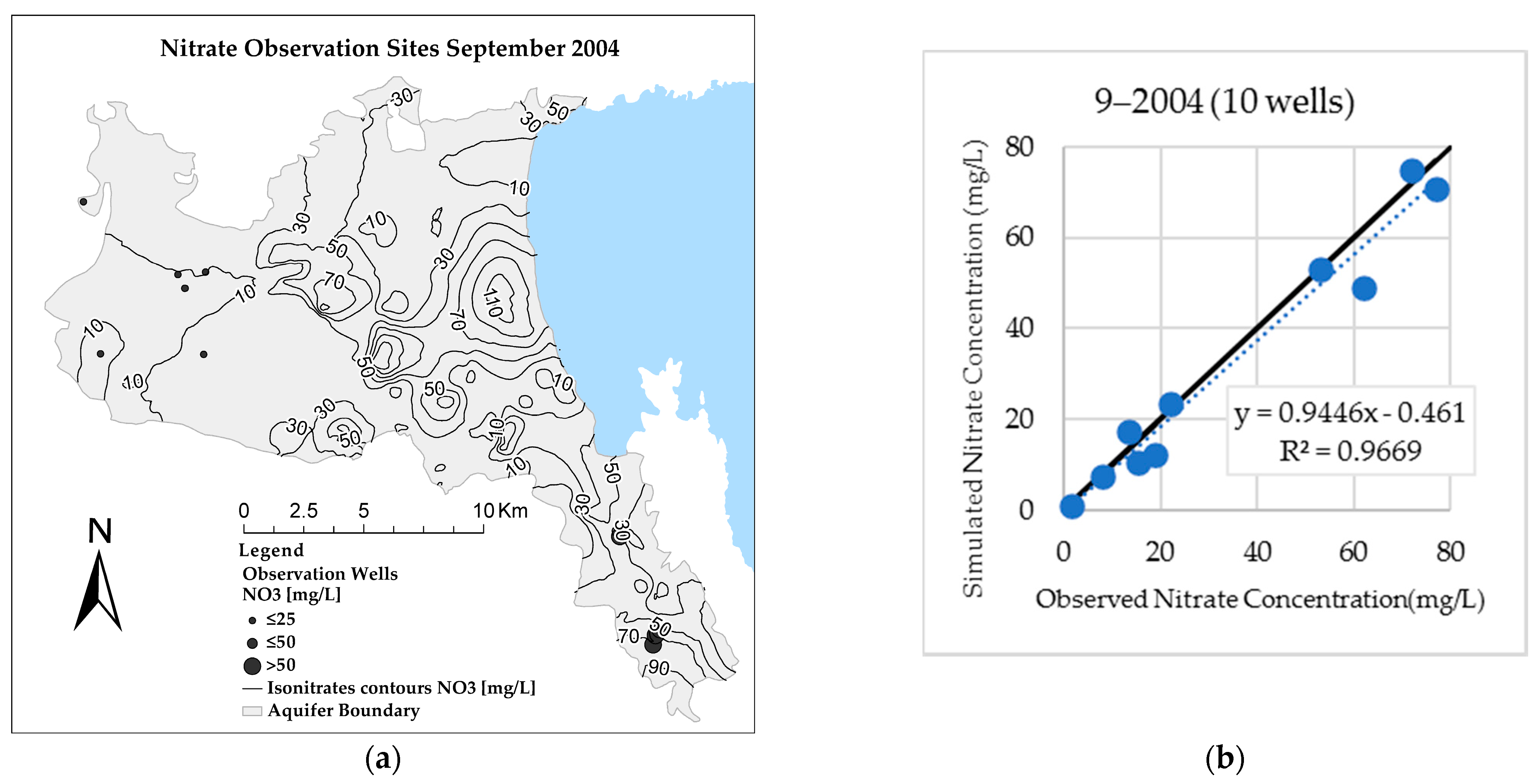
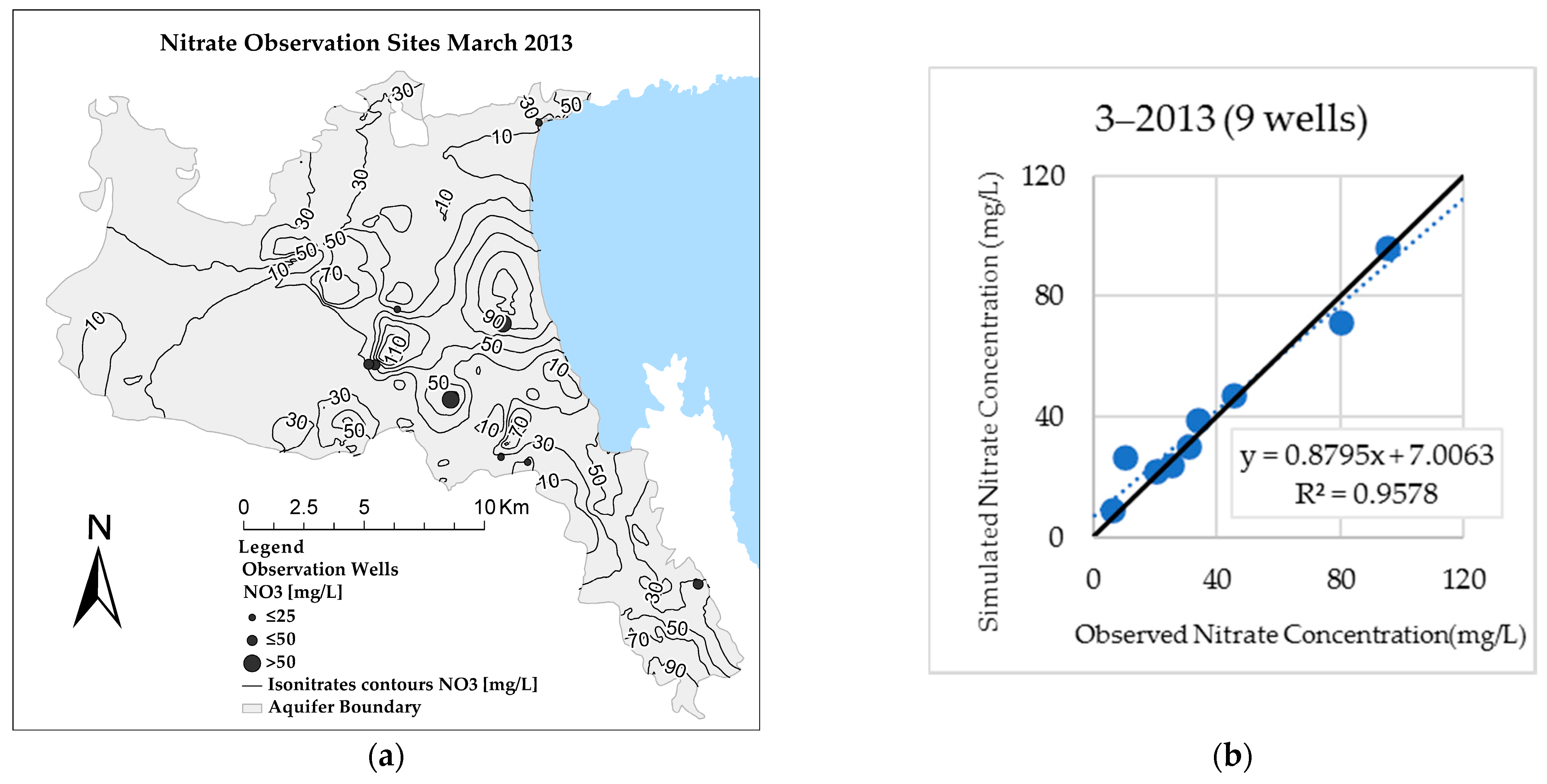
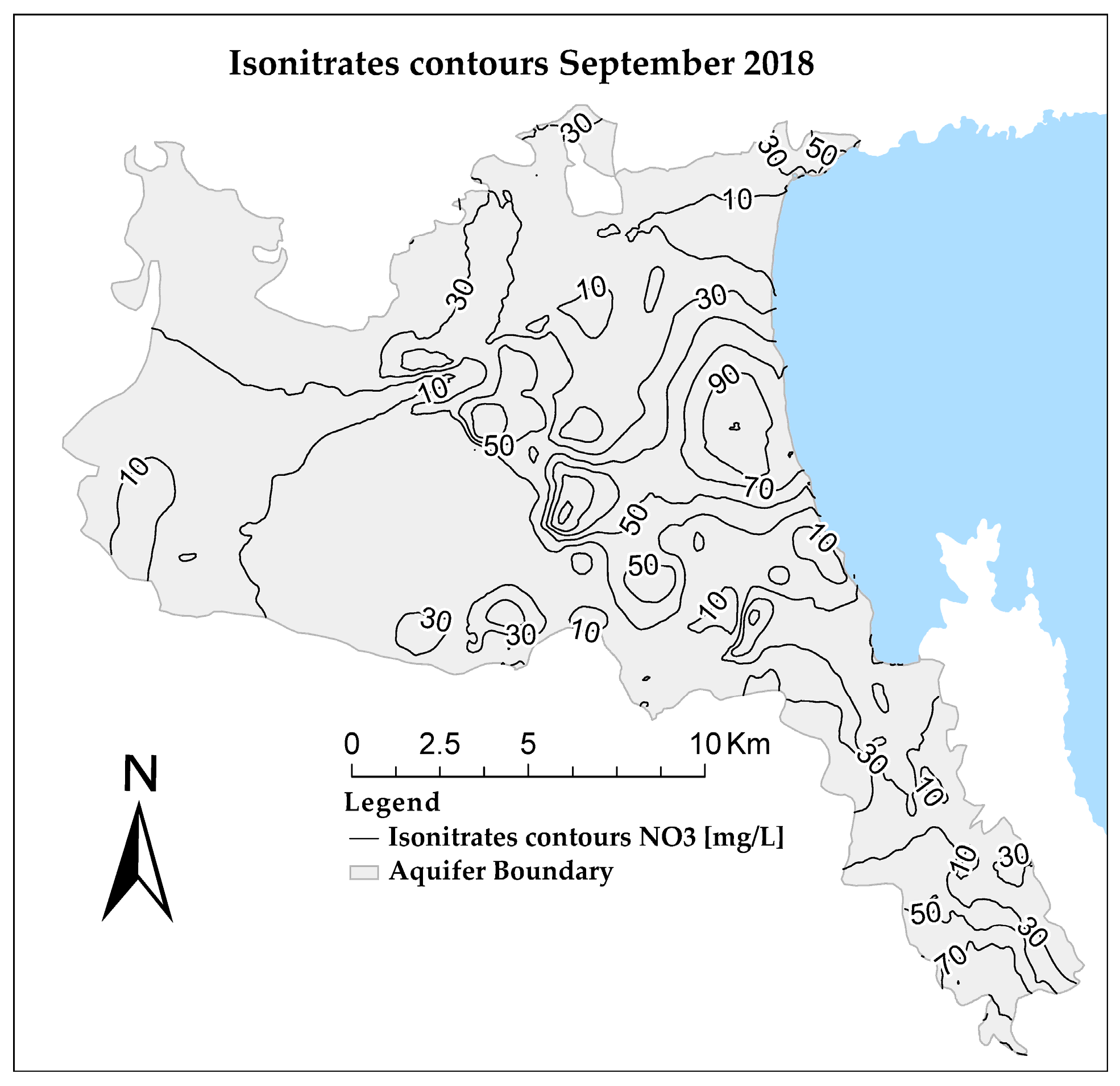
4.5. Nitrate Transport and Dispersion
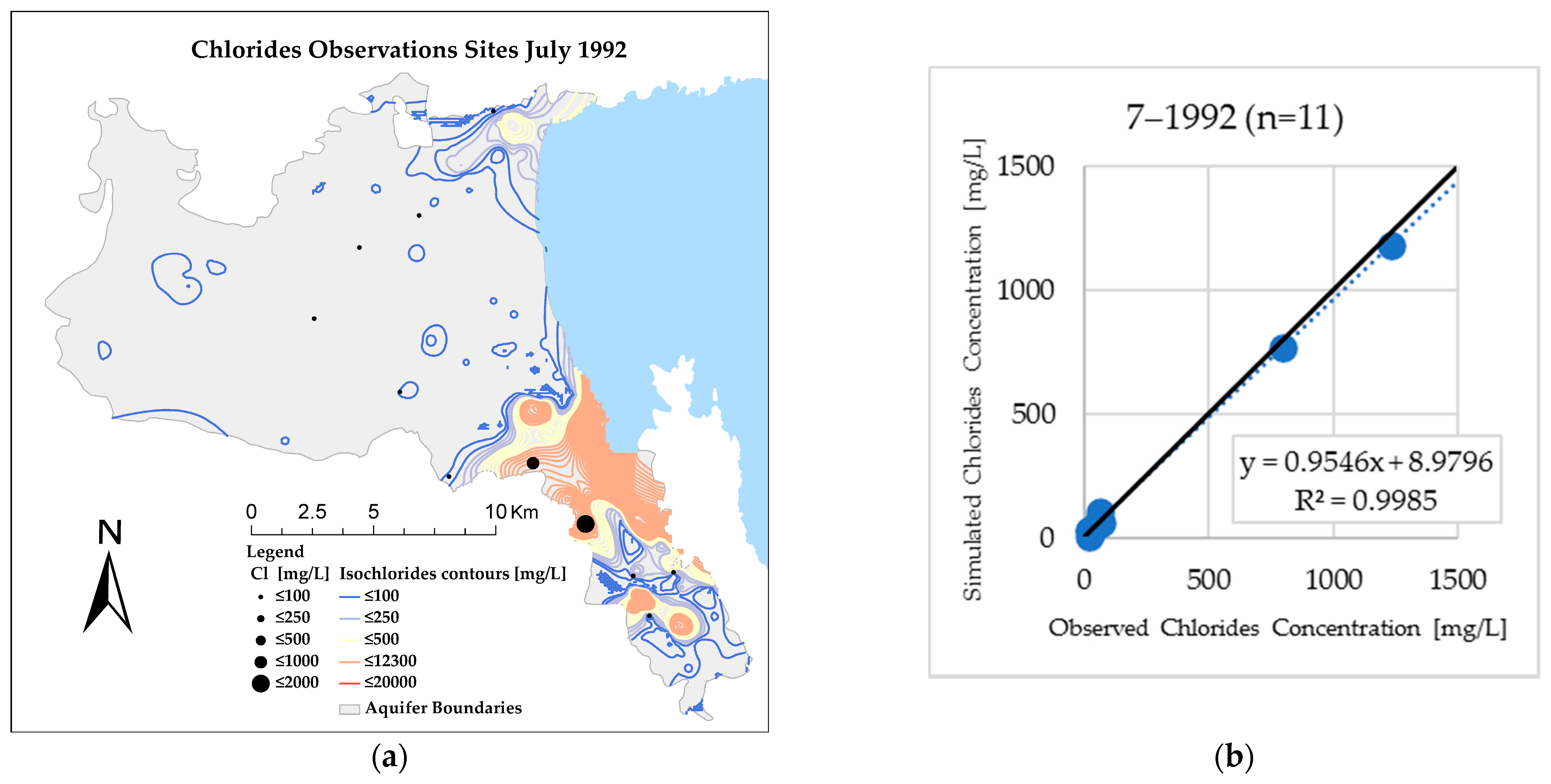
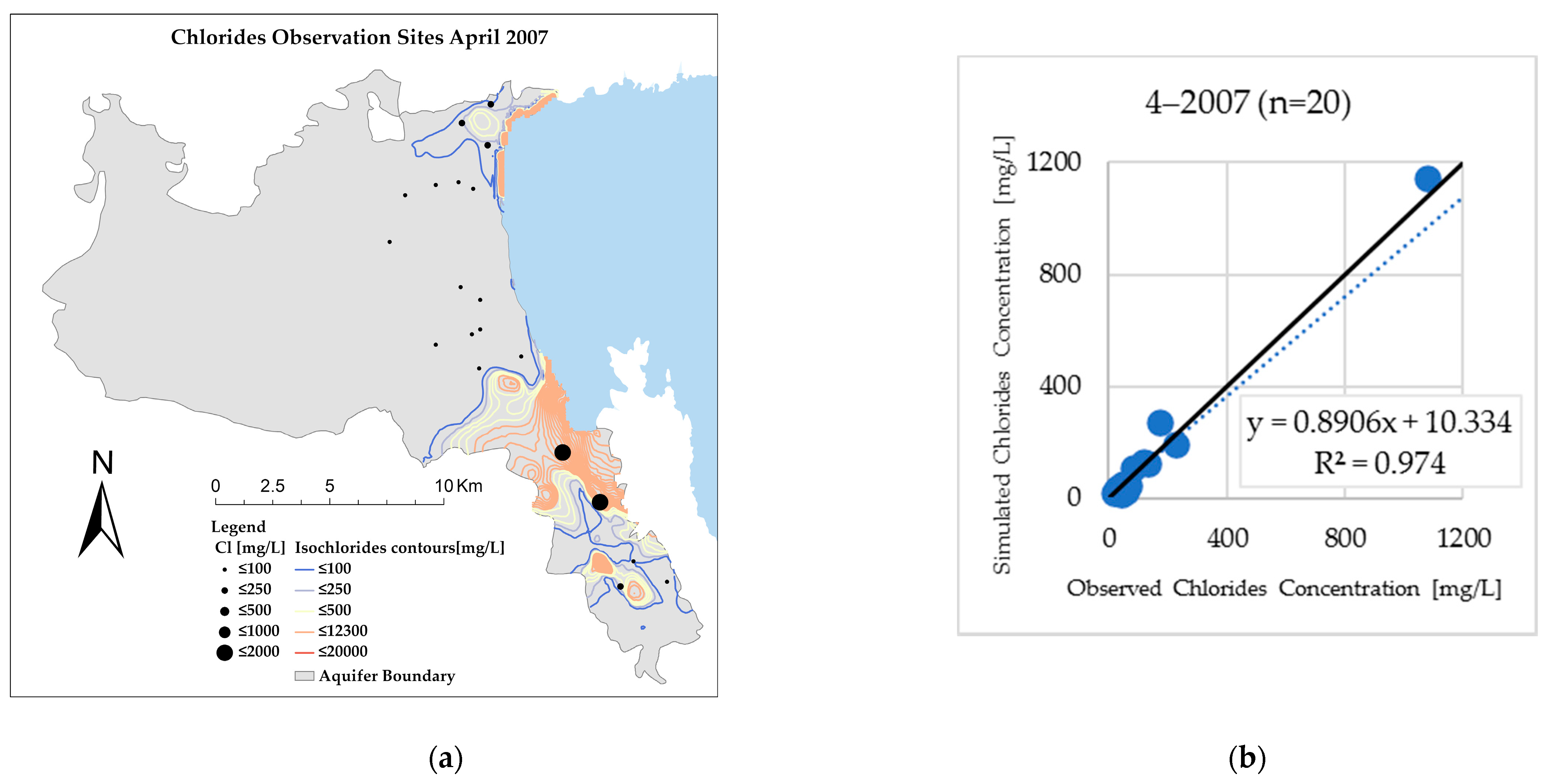
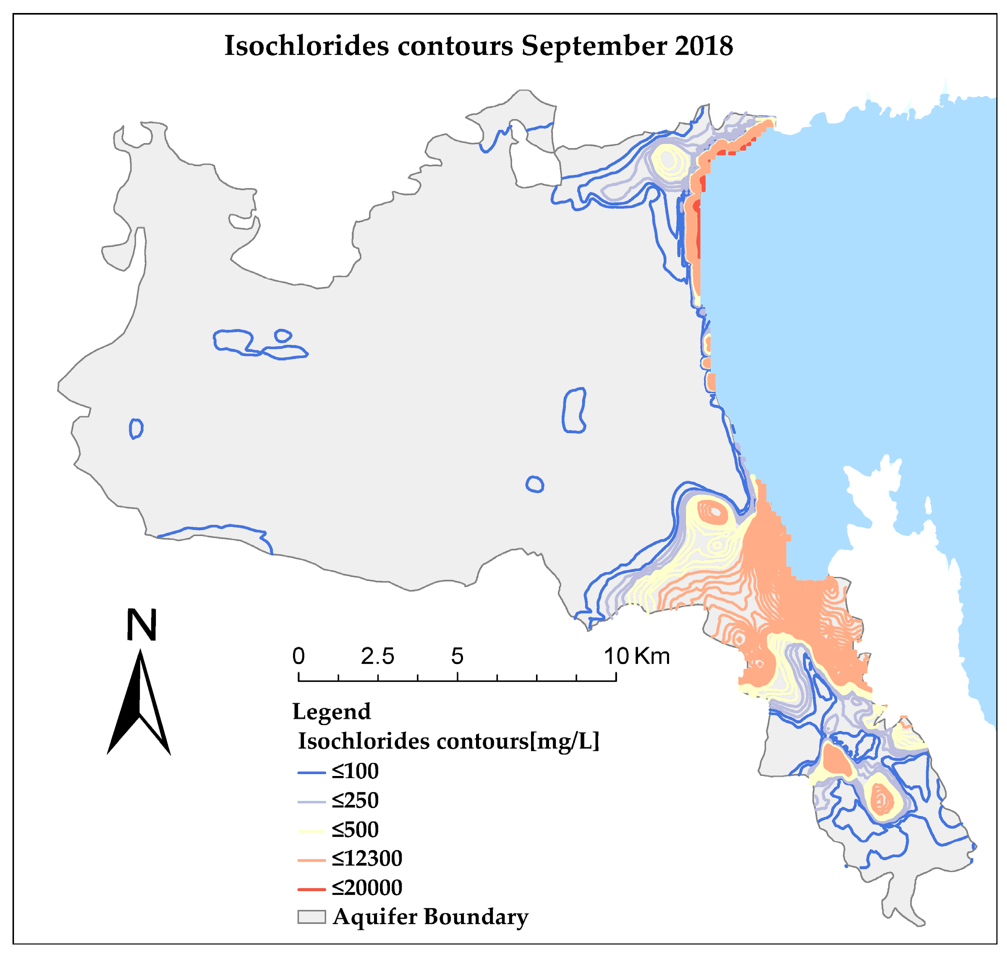
4.6. Chloride Solute Transport and Dispersion
5. Discussion
6. Conclusions
Author Contributions
Funding
Institutional Review Board Statement
Informed Consent Statement
Data Availability Statement
Acknowledgments
Conflicts of Interest
References
- Loukas, A.; Mylopoulos, N.; Vasiliades, L. A Modeling System for the Evaluation of Water Resources Management Strategies in Thessaly, Greece. Water Resour. Manag. 2007, 21, 1673–1702. [Google Scholar] [CrossRef]
- Daskalaki, P.; Voudouris, K. Groundwater quality of porous aquifers in Greece: A synoptic review. Environ. Geol. 2008, 54, 505–513. [Google Scholar] [CrossRef]
- Ghiglieri, G.; Barbieri, G.; Vernier, A.; Carletti, A.; Demurtas, N.; Pinna, R.; Pittalis, D. Potential risks of nitrate pollution in aquifers from agricultural practices in the Nurra region, northwestern Sardinia, Italy. J. Hydrol. 2009, 379, 339–350. [Google Scholar] [CrossRef]
- Colombani, N.; Mastrocicco, M.; Prommer, H.; Sbarbati, C.; Petitta, M. Fate of arsenic, phosphate and ammonium plumes in a coastal aquifer affected by saltwater intrusion. J. Contam. Hydrol. 2015, 179, 116–131. [Google Scholar] [CrossRef] [PubMed]
- Potot, C.; Féraud, G.; Schärer, U.; Barats, A.; Durrieu, G.; Le Poupon, C.; Travi, Y.; Simler, R. Groundwater and river baseline quality using major, trace elements, organic carbon and Sr–Pb–O isotopes in a Mediterranean catchment: The case of the Lower Var Valley (south-eastern France). J. Hydrol. 2012, 472–473, 126–147. [Google Scholar] [CrossRef]
- Pulido-Velazquez, M.; Peña-Haro, S.; García-Prats, A.; Mocholi-Almudever, A.F.; Henriquez-Dole, L.; Macian-Sorribes, H.; Lopez-Nicolas, A. Integrated assessment of the impact of climate and land use changes on groundwater quantity and quality in the Mancha Oriental system (Spain). Hydrol. Earth Syst. Sci. 2015, 19, 1677–1693. [Google Scholar] [CrossRef]
- Giménez-Forcada, E. Use of the Hydrochemical Facies Diagram (HFE-D) for the evaluation of salinization by seawater intrusion in the coastal Oropesa Plain: Comparative analysis with the coastal Vinaroz Plain, Spain. HydroResearch 2019, 76–84. [Google Scholar] [CrossRef]
- Rosário Cameira, M.D.; Rolim, J.; Valente, F.; Mesquita, M.; Dragosits, U.; Cordovil, C.M. Translating the agricultural N surplus hazard into groundwater pollution risk: Implications for effectiveness of mitigation measures in nitrate vulnerable zones. Agric. Ecosyst. Environ. 2021. [Google Scholar] [CrossRef]
- Telahigue, F.; Mejri, H.; Mansouri, B.; Souid, F.; Agoubi, B.; Chahlaoui, A.; Kharroubi, A. Assessing seawater intrusion in arid and semi-arid Mediterranean coastal aquifers using geochemical approaches. Phys. Chem. Earthparts A/B/C 2020, 115, 102811. [Google Scholar] [CrossRef]
- Mohammad, A.H.; Jung, H.C.; Odeh, T.; Bhuiyan, C.; Hussein, H. Understanding the impact of droughts in the Yarmouk Basin, Jordan: Monitoring droughts through meteorological and hydrological drought indices. Arab. J. Geosci. 2018, 11, 103. [Google Scholar] [CrossRef]
- Rachid, G.; Alameddine, I.; El-Fadel, M. SWOT risk analysis towards sustainable aquifer management along the Eastern Mediterranean. J. Environ. Manag. 2021, 279, 111760. [Google Scholar] [CrossRef] [PubMed]
- Cobaner, M.; Yurtal, R.; Dogan, A.; Motz, L.H. Three dimensional simulation of seawater intrusion in coastal aquifers: A case study in the Goksu Deltaic Plain. J. Hydrol. 2012, 464–465, 262–280. [Google Scholar] [CrossRef]
- EASAC. Groundwater in the Southern Member States of the European Union: An Assessment of Current Knowledge and Future Prospects; Country Report for Greece; European Academies Science Advisory Council: Harley, Germany, 2010; pp. 18–19. Available online: https://easac.eu/ (accessed on 21 January 2021).
- European Commission. Verification of Vulnerable Zones Identified Under the Nitrate Directive, Greece; European Commission: Luxembourg, 2003; Available online: https://ec.europa.eu/ (accessed on 21 January 2021).
- NCESD. Greece, State of the Environment Report, Summary; National Center of Environment and Sustainable Development: Athens, Greece, 2018; pp. 70–71. ISBN 978-960-99033-3-2. [Google Scholar]
- Sidiropoulos, P.; Tziatzios, G.; Vasiliades, L.; Papaioannou, G.; Mylopoulos, N.; Loukas, A. Modelling flow and nitrate transport in an over-exploited aquifer of rural basin using an integrated system: The case of Lake Karla watershed. Proceedings 2018, 2, 667. [Google Scholar] [CrossRef]
- EU. Report from the Commission: In Accordance with Article 3.7 of the Groundwater Directive 2006/118/EC on the Establishment of Groundwater Threshold Values; European Commission: Brussels, Belgium, 2010. [Google Scholar]
- Madani, K.; Mariño, M.A. System dynamics analysis for managing Iran’s Zayandeh-Rud river basin. Water Resour. Manag. 2009, 23, 2163–2187. [Google Scholar] [CrossRef]
- Mirchi, A. System Dynamics Modeling as a Quantitative-Qualitative Framework for Sustainable Water Resources Management: Insights for Water Quality Policy in the Great Lakes Region. Master’s Thesis, Michigan Technological University, Horton, MI, USA, 2013. [Google Scholar] [CrossRef]
- Zomorodian, M.; Lai, S.H.; Homayounfar, M.; Ibrahim, S.; Fatemi, S.E.; El-Shafie, A.J.J.o.e.m. The state-of-the-art system dynamics application in integrated water resources modeling. J. Environ. Manag. 2018, 227, 294–304. [Google Scholar] [CrossRef]
- Medici, G.; Baják, P.; West, L.J.; Chapman, P.J.; Banwart, S.A. DOC and nitrate fluxes from farmland; impact on a dolostone aquifer KCZ. J. Hydrol. 2020, 125658. [Google Scholar] [CrossRef]
- Barthel, R.; Banzhaf, S. Groundwater and Surface Water Interaction at the Regional-scale—A Review with Focus on Regional Integrated Models. Water Resour. Manag. 2016, 30, 1–32. [Google Scholar] [CrossRef]
- Milano, M.; Ruelland, D.; Fernandez, S.; Dezetter, A.; Fabre, J.; Servat, E.; Fritsch, J.-M.; Ardoin-Bardin, S.; Thivet, G. Current state of Mediterranean water resources and future trends under climatic and anthropogenic changes. Hydrol. Sci. J. 2013, 58, 498–518. [Google Scholar] [CrossRef]
- Feng, D.; Zheng, Y.; Mao, Y.; Zhang, A.; Wu, B.; Li, J.; Tian, Y.; Wu, X. An integrated hydrological modeling approach for detection and attribution of climatic and human impacts on coastal water resources. J. Hydrol. 2018, 557, 305–320. [Google Scholar] [CrossRef]
- Riad, P.; Graefe, S.; Hussein, H.; Buerkert, A. Landscape transformation processes in two large and two small cities in Egypt and Jordan over the last five decades using remote sensing data. Landsc. Urban Plan. 2020, 197, 103766. [Google Scholar] [CrossRef]
- Bobba, A.G. Ground Water-Surface Water Interface (GWSWI) Modeling: Recent Advances and Future Challenges. Water Resour. Manag. 2012, 26, 4105–4131. [Google Scholar] [CrossRef]
- Mylopoulos, N.; Kolokytha, E.; Loukas, A.; Mylopoulos, Y. Agricultural and water resources development in Thessaly, Greece in the framework of new European Union policies. Int. J. River Basin Manag. 2009, 7, 73–89. [Google Scholar] [CrossRef]
- Sidiropoulos, P.; Loukas, A.; Georgiadou, I. Response of a degraded coastal aquifer to water resources management. Eur. Water 2016, 55, 67–77. [Google Scholar]
- Daliakopoulos, I.N.; Tsanis, I.K.; Koutroulis, A.; Kourgialas, N.N.; Varouchakis, A.E.; Karatzas, G.P.; Ritsema, C.J. The threat of soil salinity: A European scale review. Sci. Total Environ. 2016, 573, 727–739. [Google Scholar] [CrossRef] [PubMed]
- Ketabchi, H.; Mahmoodzadeh, D.; Ataie-Ashtiani, B.; Simmons, C.T. Sea-level rise impacts on seawater intrusion in coastal aquifers: Review and integration. J. Hydrol. 2016, 535, 235–255. [Google Scholar] [CrossRef]
- Barthel, R.; Reichenau, T.G.; Krimly, T.; Dabbert, S.; Schneider, K.; Mauser, W. Integrated Modeling of Global Change Impacts on Agriculture and Groundwater Resources. Water Resour. Manag. 2012, 26, 1929–1951. [Google Scholar] [CrossRef]
- Le Page, M.; Fakir, Y.; Aouissi, J. Chapter 7—Modeling for integrated water resources management in the Mediterranean region. In Water Resources in the Mediterranean Region; Zribi, M., Brocca, L., Tramblay, Y., Molle, F., Eds.; Elsevier: Amsterdam, The Netherlands, 2020; pp. 157–190. [Google Scholar] [CrossRef]
- Burek, P.; Satoh, Y.; Kahil, T.; Tang, T.; Greve, P.; Smilovic, M.; Guillaumot, L.; Zhao, F.; Wada, Y. Development of the Community Water Model (CWatM v1.04)—A high-resolution hydrological model for global and regional assessment of integrated water resources management. Geosci. Model Dev. 2020, 13, 3267–3298. [Google Scholar] [CrossRef]
- Odeh, T.; Mohammad, A.H.; Hussein, H.; Ismail, M.; Almomani, T. Over-pumping of groundwater in Irbid governorate, northern Jordan: A conceptual model to analyze the effects of urbanization and agricultural activities on groundwater levels and salinity. Environ. Earth Sci. 2019, 78, 40. [Google Scholar] [CrossRef]
- Medici, G.; West, L.J.; Chapman, P.J.; Banwart, S.A. Prediction of contaminant transport in fractured carbonate aquifer types: A case study of the Permian Magnesian Limestone Group (NE England, UK). Environ. Sci. Pollut. Res. 2019, 26, 24863–24884. [Google Scholar] [CrossRef]
- Wang, K.; Davies, E.G.R.; Liu, J. Integrated water resources management and modeling: A case study of Bow river basin, Canada. J. Clean. Prod. 2019, 240, 118242. [Google Scholar] [CrossRef]
- Rossetto, R.; De Filippis, G.; Borsi, I.; Foglia, L.; Cannata, M.; Criollo, R.; Vázquez-Suñé, E. Integrating free and open source tools and distributed modelling codes in GIS environment for data-based groundwater management. Environ. Model. Softw. 2018, 107, 210–230. [Google Scholar] [CrossRef]
- Wang, L.; Stuart, M.E.; Lewis, M.A.; Ward, R.S.; Skirvin, D.; Naden, P.S.; Collins, A.L.; Ascott, M.J. The changing trend in nitrate concentrations in major aquifers due to historical nitrate loading from agricultural land across England and Wales from 1925 to 2150. Sci. Total Environ. 2016, 542, 694–705. [Google Scholar] [CrossRef] [PubMed]
- Ragab, R.; Bromley, J.; D’Agostino, D.R.; Lamaddalena, N.; Luizzi, G.T.; Dörflinger, G.; Katsikides, S.; Montenegro, S.; Montenegro, A. Water Resources Management Under Possible Future Climate and Land Use Changes: The Application of the Integrated Hydrological Modelling System, IHMS. In Integrated Water Resources Management in the Mediterranean Region: Dialogue towards New Strategy; Choukr-Allah, R., Ragab, R., Rodriguez-Clemente, R., Eds.; Springer: Dordrecht, The Netherlands, 2012; pp. 69–90. [Google Scholar] [CrossRef]
- Harbaugh, A.W.; McDonald, M.G. User’s Documentation for MODFLOW-2000, an Update to the U.S. Geological Survey Modular Finite-Difference Ground-Water Flow Model; United States Government Printing Office: Washington, DC, USA, 2000. [Google Scholar]
- Williams, J.R. The EPIC Model. In Computer Models of Watershed Hydrology; Singh, V.P., Ed.; Water Resources Publisher: Highlands Ranch, CO, USA, 1995; pp. 909–1000. [Google Scholar]
- Zheng, C.; Wang, P.P. MT3DMS: A Modular Three-Dimensional Multi-Species Transport Model for Simulation of Advection, Dispersion and Chemical Reactions of Contaminants in Groundwater Systems, Documentation and User’s Guide; Contract Report SERDP-99-1; U.S. Army Engineer Research and Development Center: Vicksburg, MS, USA, 1999. [Google Scholar]
- Guo, W.; Langevin, C.D. User’s Guide to SEAWAT: A Computer Program for Simulation of Three-Dimensional Variable-Density Ground-Water Flow; Techniques of Water-Resources Investigation; U.S. Geological Survey: Reston, VA, USA, 2002.
- Liu, J.; Williams, J.R.; Zehnder, A.J.B.; Yang, H. GEPIC—Modelling wheat yield and crop water productivity with high resolution on a global scale. Agric. Syst. 2007, 94, 478–493. [Google Scholar] [CrossRef]
- Gardener, M. Beginning R: The Statistical Programming Language; John Wiley & Sons: Hoboken, NJ, USA, 2012. [Google Scholar]
- Pobuda, M. Using the R-ArcGIS Bridge: The Arcgisbinding Package. Available online: https://r.esri.com/assets/arcgisbinding-vignette.html (accessed on 21 January 2021).
- TexasA & Magriliferesearch. EPIC & APEX Models. Available online: https://epicapex.tamu.edu/ (accessed on 21 January 2021).
- U.S. Soil Conservation Service. National Engineering Handbook, Section 4—Hydrology; United States Department of Agriculture: Washington, DC, USA, 1972.
- Thiessen, A.H. Precipitation averages for large areas. Mon. Weather Rev. 1911, 39, 1082–1089. [Google Scholar] [CrossRef]
- Fiedler, F.R. Simple, Practical Method for Determining Station Weights Using Thiessen Polygons and Isohyetal Maps. J. Hydrol. Eng. 2003, 8, 219–221. [Google Scholar] [CrossRef]
- Şen, Z. Average areal precipitation by percentage weighted polygon method. J. Hydrol. Eng. 1998, 3, 69–72. [Google Scholar] [CrossRef]
- Thornthwaite, C.W. An Approach toward a Rational Classification of Climate. Geogr. Rev. 1948, 38, 55–94. [Google Scholar] [CrossRef]
- Sidiropoulos, P.; Tziatzios, G.; Vasiliades, L.; Mylopoulos, N.; Loukas, A. Groundwater Nitrate Contamination Integrated Modeling for Climate and Water Resources Scenarios: The Case of Lake Karla Over-Exploited Aquifer. Water 2019, 11, 1201. [Google Scholar] [CrossRef]
- McDonald, M.G.; Harbaugh, A.W.; original authors of MODFLOW. The History of MODFLOW. Groundwater 2003, 41, 280–283. [Google Scholar] [CrossRef]
- Tziatzios, G.; Sidiropoulos, P.; Vasiliades, L.; Mylopoulos, N.; Loukas, A. Simulation of Nitrate Contamination in Lake Karla Aquifer. In Proceedings of the 14th International Conference on Environmental Science and Technology (CEST2015), Rhodes, Greece, 3–5 September 2015; Available online: https://cest2015.gnest.org/papers/cest2015_00121_oral_paper.pdf (accessed on 21 January 2021).
- Psilovikos, A.A. Optimization models in groundwater management, based on linear and mixed integer programming. An application to a Greek hydrogeological basin. Phys. Chem. Earth 1999, 24, 139–144. [Google Scholar] [CrossRef]
- Siarkos, I.; Latinopoulos, P. Modeling seawater intrusion in overexploited aquifers in the absence of sufficient data: Application to the aquifer of Nea Moudania, northern Greece. Hydrogeol. J. 2016, 24, 2123–2141. [Google Scholar] [CrossRef]
- Kopsiaftis, G.; Mantoglou, A.; Giannoulopoulos, P. Variable density coastal aquifer models with application to an aquifer on Thira Island. Desalination 2009, 237, 65–80. [Google Scholar] [CrossRef]
- Kourakos, G.; Mantoglou, A. Pumping optimization of coastal aquifers based on evolutionary algorithms and surrogate modular neural network models. Adv. Water Resour. 2009, 32, 507–521. [Google Scholar] [CrossRef]
- Kaleris, V.K.; Ziogas, A.I. Using electrical resistivity logs and short duration pumping tests to estimate hydraulic conductivity profiles. J. Hydrol. 2020, 590, 125–277. [Google Scholar] [CrossRef]
- Kopsiaftis, G.; Tigkas, D.; Christelis, V.; Vangelis, H. Assessment of drought impacts on semi-arid coastal aquifers of the Mediterranean. J. Arid Environ. 2017, 137, 7–15. [Google Scholar] [CrossRef]
- Kritsotakis, M.; Tsanis, I.K. An integrated approach for sustainable water resources management of Messara basin, Crete, Greece. Eur. Water 2009, 27, 15–30. [Google Scholar]
- Williams, J.; Jones, C.; Dyke, P. The EPIC Model and its Application. In Proceedings of the ICRISAT-IBSNAT-SYSS S International Symposium on Minimum Data Sets for Agrotechnology Transfer, Patancheru, India, 21–26 March 1983; pp. 111–121. [Google Scholar]
- Wang, X.; Williams, J.; Gassman, P.; Baffaut, C.; Izaurralde, R.; Jeong, J.; Kiniry, J.R. EPIC and APEX: Model use, calibration, and validation. Trans. ASABE 2012, 55, 1447–1462. [Google Scholar] [CrossRef]
- Sharpley, A.N.; Williams, J.R. EPIC-Erosion/Productivity Impact Calculator. I: Model Documentation. II: User Manual; Agricultural Research Service: Washington, DC, USA, 1990.
- Liu, W.; Yang, H.; Liu, J.; Azevedo, L.B.; Wang, X.; Xu, Z.; Abbaspour, K.C.; Schulin, R. Global assessment of nitrogen losses and trade-offs with yields from major crop cultivations. Sci. Total Environ. 2016, 572, 526–537. [Google Scholar] [CrossRef]
- Yin, Y.; Zhang, X.; Yu, H.; Lin, D.; Wu, Y.; Wang, J.a. Mapping Drought Risk (Maize) of the World. In World Atlas of Natural Disaster Risk; Shi, P., Kasperson, R., Eds.; Springer: Berlin/Heidelberg, Germany, 2015; pp. 211–226. [Google Scholar] [CrossRef]
- Zhang, X.; Lin, D.; Guo, H.; Wu, Y.; Wang, J.a. Mapping Drought Risk (Rice) of the World. In World Atlas of Natural Disaster Risk; Shi, P., Kasperson, R., Eds.; Springer: Berlin/Heidelberg, Germany, 2015; pp. 243–258. [Google Scholar] [CrossRef]
- Liu, J.; Fritz, S.; van Wesenbeeck, C.F.A.; Fuchs, M.; You, L.; Obersteiner, M.; Yang, H. A spatially explicit assessment of current and future hotspots of hunger in Sub-Saharan Africa in the context of global change. Glob. Planet. Chang. 2008, 64, 222–235. [Google Scholar] [CrossRef]
- Liu, J.; Wiberg, D.; Zehnder, A.J.; Yang, H.J.I.S. Modeling the role of irrigation in winter wheat yield, crop water productivity, and production in China. Irrig. Sci. 2007, 26, 21–33. [Google Scholar] [CrossRef]
- Koch, J.; Wimmer, F.; Schaldach, R.; Onigkeit, J. An integrated land-use system model for the Jordan River region. In Environmental Land Use Planning; Seth Appiah-Opoku InTechOpen: Tuscaloosa, AL, USA, 2012; Available online: https://www.intechopen.com/books/environmental-land-use-planning/an-integrated-land-use-system-model-for-the-jordan-river-region (accessed on 21 January 2021).
- Zheng, C.; Bennett, G. Applied Contaminant Transport Modeling, 2nd ed.; Wiley-Interscience: New York, NY, USA, 2002; Volume 34. [Google Scholar]
- Anderson, M.P.; Cherry, J.A. Using models to simulate the movement of contaminants through groundwater flow systems. Crit. Rev. Environ. Control 1979, 9, 97–156. [Google Scholar] [CrossRef]
- Neuman, S.P. Universal scaling of hydraulic conductivities and dispersivities in geologic media. Water Resour. Res. 1990, 26, 1749–1758. [Google Scholar] [CrossRef]
- Psaropoulou, E.T.; Karatzas, G.P. Pollution of nitrates—contaminant transport in heterogeneous porous media: A case study of the coastal aquifer of Corinth, Greece. Glob. Nest J. 2014, 16, 9–23. [Google Scholar] [CrossRef][Green Version]
- Guo, W.; Bennett, G.D. Simulation of Saline/Fresh Water Flows Using MODFLOW. In Proceedings of the MODFLOW 98 Conference, Golden, CO, USA, 4–8 October 1998; pp. 267–274. [Google Scholar]
- Siarkos, I.; Latinopoulos, D.; Mallios, Z.; Latinopoulos, P. A methodological framework to assess the environmental and economic effects of injection barriers against seawater intrusion. J. Environ. Manag. 2017, 193, 532–540. [Google Scholar] [CrossRef]
- Nash, J.E.; Sutcliffe, J.V. River flow forecasting through conceptual models part I—A discussion of principles. J. Hydrol. 1970, 10, 282–290. [Google Scholar] [CrossRef]
- Colin Cameron, A.; Windmeijer, F.A.G. An R-squared measure of goodness of fit for some common nonlinear regression models. J. Econom. 1997, 77, 329–342. [Google Scholar] [CrossRef]
- Matthews, J.; Bendig, A.W. The index of agreement: A possible criterion for measuring the outcome of group discussion. Speech Monogr. 1955, 22, 39–42. [Google Scholar] [CrossRef]
- Smalheiser, N.R. Chapter 9—Null Hypothesis Statistical Testing and the t-test. In Data Literacy; Smalheiser, N.R., Ed.; Academic Press: New York, NY, USA, 2017; pp. 127–136. [Google Scholar] [CrossRef]
- Lyra, A.; Pliakas, F.; Skias, S.; Gkiougkis, I. Implementation of DPSIR framework in the management of the Almyros basin, Magnesia Prefecture. Bull. Geol. Soc. Greece 2016, 50, 825–834. [Google Scholar] [CrossRef][Green Version]
- Stevenson, D.S. Irrigation Efficiency in Orchards. Can. Water Resour. J. 1980, 5, 102–110. [Google Scholar] [CrossRef]
- Dewandel, B.; Gandolfi, J.-M.; de Condappa, D.; Ahmed, S. An efficient methodology for estimating irrigation return flow coefficients of irrigated crops at watershed and seasonal scale. Hydrol. Process. 2008, 22, 1700–1712. [Google Scholar] [CrossRef]
- Willis, T.M.; Black, A.S.; Meyer, W.S. Estimates of deep percolation beneath cotton in the Macquarie Valley. Irrig. Sci. 1997, 17, 141–150. [Google Scholar] [CrossRef]
- Panagos, P.; Van Liedekerke, M.; Jones, A.; Montanarella, L. European Soil Data Centre: Response to European policy support and public data requirements. Land Use Policy 2012, 29, 329–338. [Google Scholar] [CrossRef]
- ESDAC. European Soil Data Centre, Joint Research Centre, European Commission. Available online: esdac.jrc.ec.europa.eu (accessed on 21 January 2021).
- Soil Science Division Staff. Soil Survey Manual; Ditzler, C., Scheffe, K., Monger, H.C., Eds.; USDA Handbook, 18; Government Printing Office: Washington, DC, USA, 2017. Available online: https://www.nrcs.usda.gov/wps/portal/nrcs/detail/soils/scientists/?cid=nrcs142p2_054262 (accessed on 21 January 2021).
- MEE. Ministry of Environment and Energy, Secretariat of National Environment and Water. Available online: http://lmt.ypeka.gr/public_view.html (accessed on 21 January 2021).
- Merwade, V. Creating SCS Curve Number Grid Using HEC-GeoHMS. 2012. Available online: http://web.ics.purdue.edu/~vmerwade/tutorial.html (accessed on 21 January 2021).
- Dastane, N. Effective Rainfall, FAO Irrigation and Drainage Paper No. 25; Food and Agriculture Organization: Rome, Italy, 1974. [Google Scholar]
- Wichmann, W. World Fertilizer Use Manual; International Fertilizer Industry Association (IFA): Paris, France, 1992. [Google Scholar]
- Tang, A.; Sandall, O.C. Diffusion coefficient of chlorine in water at 25–60 °C. J. Chem. Eng. Data 1985, 30, 189–191. [Google Scholar] [CrossRef]
- Petihakis, G.; Triantafyllou, G.; Pollani, A.; Koliou, A.; Theodorou, A. Field data analysis and application of a complex water column biogeochemical model in different areas of a semi-enclosed basin: Towards the development of an ecosystem management tool. Mar. Environ. Res. 2005, 59, 493–518. [Google Scholar] [CrossRef] [PubMed]


| Main Land Use/Crop | 2010 (% Area) | 2018 (% Area) | Irrigation Return Flow Coefficient |
|---|---|---|---|
| Alfalfa | 7.74 | 16.83 | 0.15 |
| Cereals | 10.33 | 25.16 | 0.15 |
| Cotton | 8.55 | 8.40 | 0.20 |
| Maize | 2.55 | 1.62 | 0.35 |
| Olives | 10.86 | 12.91 | 0.13 |
| Trees | 1.34 | 2.36 | 0.13 |
| Vegetables | 1.62 | 6.56 | 0.24 |
| Vineyards | 2.02 | 2.46 | 0.13 |
| Wheat | 32.75 | 9.92 | 0.19 |
| Soil Texture Class | % Area |
|---|---|
| Sandy Loam | 1.1 |
| Loam | 10.4 |
| Silt Loam | 21.4 |
| Sandy Clay Loam | 2.6 |
| Clay Loam | 35.2 |
| Silty Clay Loam | 6.5 |
| Sandy Clay | 0.2 |
| Silty Clay | 1.3 |
| Clay | 21.3 |
| Sandy Loam | 1.1 |
| Precipitation Station | Slope | Intercept | R2 | R |
|---|---|---|---|---|
| N. Aghialos | 1.00 | 1.00 | 1.00 | 1.00 |
| Anavra | 0.93 | 15.49 | 0.74 | 0.86 |
| Skopia | 0.96 | 6.71 | 0.69 | 0.83 |
| Volos | 0.99 | 0.00 | 0.90 | 0.95 |
| Pigadi | 0.90 | 10.43 | 0.65 | 0.80 |
| Temperature Station | Slope | Intercept | R2 | R |
|---|---|---|---|---|
| N. Aghialos | 1.00 | 1.00 | 1.00 | 1.00 |
| Pigadi | 0.84 | 2.94 | 0.16 | 0.40 |
| Volos | 0.93 | 2.12 | 0.29 | 0.54 |
| Skopia | 0.97 | −1.10 | 0.37 | 0.61 |
| Sotirio | 0.11 | 1.00 | 0.40 | 0.63 |
| Farsala | 0.83 | −0.86 | 0.42 | 0.64 |
| Basin | CN |
|---|---|
| Almyros | 61.43 |
| Kazani | 67.93 |
| Lahanorema | 68.11 |
| Holorema | 68.47 |
| Xirias | 60.69 |
| Platanorema | 51.07 |
| Xirorema | 53.84 |
| Sub-Basin | Pb [mm] | Qc [mm] | Rg [mm] | Qc/Pb | Rg/Qc | Rg/Pb |
|---|---|---|---|---|---|---|
| Kazani | 507.9 | 97.5 | 56.3 | 19.2% | 57.7% | 11.09% |
| Lachanorema | 522.8 | 103.6 | 62.5 | 19.8% | 60.4% | 11.96% |
| Holorema | 527.9 | 105.5 | 65.1 | 20.0% | 61.7% | 12.33% |
| Xirias | 590.4 | 125.4 | 63.5 | 21.2% | 50.7% | 10.76% |
| Platanorema | 617.8 | 127.46 | 34.2 | 20.6% | 26.8% | 5.54% |
| Xirorema | 596.6 | 112.4 | 31.9 | 18.8% | 28.4% | 5.35% |
| MODFLOW | Calibration Average 1991–2009 | Validation Average 2013–2015 |
|---|---|---|
| Eff | 0.975 | 0.997 |
| R2 | 0.981 | 0.997 |
| IA | 0.993 | 0.999 |
| Crop | NIR [mm] | NFer [Kg/ha] |
|---|---|---|
| Alfalfa | 893 | 30 |
| Cereals | 336 | 100 |
| Cotton | 409 | 140 |
| Maize | 389 | 325 |
| Olives | 515 | 125 |
| Trees | 515 | 175 |
| Vegetables | 271 | 150 |
| Vineyards | 297 | 125 |
| Wheat | 336 | 160 |
| Crop | Calibration Average 2007–2012 | Validation Average 2013–2018 |
|---|---|---|
| Eff | 0.98 | 0.92 |
| R2 | 0.99 | 0.96 |
| IA | 0.99 | 0.99 |
| MT3DMS | Calibration Average 1992–2004 | Validation Average 2013–1015 |
|---|---|---|
| Eff | 0.80 | 0.82 |
| R2 | 0.87 | 0.96 |
| IA | 0.95 | 0.95 |
| SEAWAT | Calibration Average 1991–2004 | Validation Average 2005–2007 |
|---|---|---|
| Eff | 0.92 | 0.89 |
| R2 | 0.94 | 0.95 |
| IA | 0.98 | 0.98 |
Publisher’s Note: MDPI stays neutral with regard to jurisdictional claims in published maps and institutional affiliations. |
© 2021 by the authors. Licensee MDPI, Basel, Switzerland. This article is an open access article distributed under the terms and conditions of the Creative Commons Attribution (CC BY) license (http://creativecommons.org/licenses/by/4.0/).
Share and Cite
Lyra, A.; Loukas, A.; Sidiropoulos, P.; Tziatzios, G.; Mylopoulos, N. An Integrated Modeling System for the Evaluation of Water Resources in Coastal Agricultural Watersheds: Application in Almyros Basin, Thessaly, Greece. Water 2021, 13, 268. https://doi.org/10.3390/w13030268
Lyra A, Loukas A, Sidiropoulos P, Tziatzios G, Mylopoulos N. An Integrated Modeling System for the Evaluation of Water Resources in Coastal Agricultural Watersheds: Application in Almyros Basin, Thessaly, Greece. Water. 2021; 13(3):268. https://doi.org/10.3390/w13030268
Chicago/Turabian StyleLyra, Aikaterini, Athanasios Loukas, Pantelis Sidiropoulos, Georgios Tziatzios, and Nikitas Mylopoulos. 2021. "An Integrated Modeling System for the Evaluation of Water Resources in Coastal Agricultural Watersheds: Application in Almyros Basin, Thessaly, Greece" Water 13, no. 3: 268. https://doi.org/10.3390/w13030268
APA StyleLyra, A., Loukas, A., Sidiropoulos, P., Tziatzios, G., & Mylopoulos, N. (2021). An Integrated Modeling System for the Evaluation of Water Resources in Coastal Agricultural Watersheds: Application in Almyros Basin, Thessaly, Greece. Water, 13(3), 268. https://doi.org/10.3390/w13030268